Sasanka Madawalagama Geoinformatics Center Asian Institute of Technology Thailand
|
|
|
- Silvia Greene
- 6 years ago
- Views:
Transcription


1 Sasanka Madawalagama Geoinformatics Center Asian Institute of Technology Thailand This learning material was not prepared by ADB. The views expressed in this document are the views of the author/s and do not necessarily reflect the views or policies of the Asian Development Bank or its Board of Governors, or the governments they represent. ADB does not guarantee the accuracy of the data included in this presentation and accepts no responsibility for any consequence of their use. The countries listed in this presentation do not imply any view on ADB s part as to sovereignty or independent status or necessarily conform to ADB s terminology.
2
3 Photogrammetry Photo - light gramma - something drawn metrein - measure Photogrammetry = measuring with photographs Objective is Inverse the process of photography (i.e. reconstruction of the object space from image space). Results can be, Topographical/Planimetric/Thematic maps 3D Models Coordinates of the required object points Rectified Photos


4 2D 3D Why? Can you used aerial photograph as a map directly? Single Point Perspective The photo scale is different at the tops of the buildings than at the street level. The tops of the building are displaced radially outward relative to their location at the center.

5 How to prepare maps from Aerial Photographs? 3D Real World Central Projection Aerial Photo -2D Orthogonal Projection Map -2D Ground Model -3D

6 2D 3D Multiple observations from different directions allows for estimating the 3D location of points via triangulation

7 Orthoimages
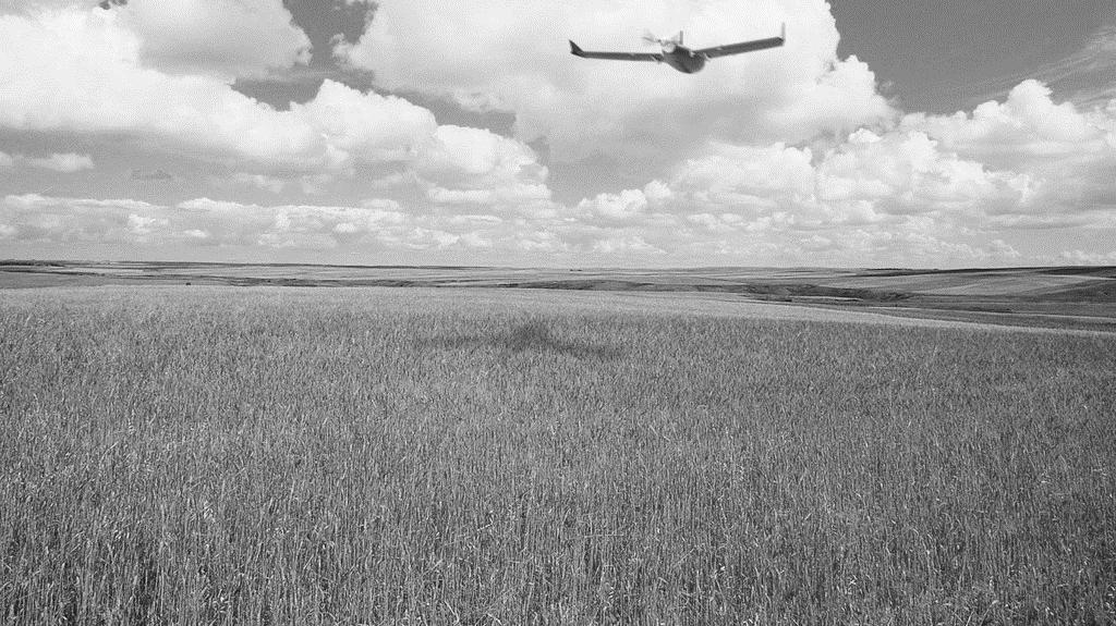
8 Drones for Mapping How it Works Drone Platform to carry imaging sensor through accurate flight path. Camera Captures overlapping images while in motion Algorithm Computer Vision + Photogrammetry Extracts geometry through matches of thousands of keypoints for generating accurate maps and 3D models.

9 Cameras to Measure Directions


")


10 Cameras for Drones Consumer grade cameras Point and shoot cameras Mirrorless cameras DSLR (heavy payload; not much conventional) Multi Spectral Cameras Parrot Sequoia Sony WX Default camera for ebee Sony A6000 Canon EOS 5D


11 Drones for Mapping How it Works Drone Platform to carry imaging sensor through accurate flight path. Camera Captures overlapping images while in motion Algorithm Computer Vision + Photogrammetry Extracts geometry through matches of thousands of keypoints for generating accurate maps and 3D models.


12 General Workflow of UAV Mapping Flight Planning Fight Map Specifications Image Acquisition + GCPs Photogrammetric Processing Camera Calibration Sparse Cloud Generation Dense Cloud Generation Mesh Texture Orthoimage, DSM and 3D Model Generation


13 General Workflow of UAV Mapping Flight Planning Fight Map Specifications Flight Planning - Flight Map - where the photographs are to be taken - Specifications - which outline how to take them Image Acquisition + GCPs Photogrammetric Processing Orthoimage, DSM and 3D Model Generation

14 Flight Alignment
15 Flight Alignment Highly dependent on your application Ex: 3D modelling

16 Photographic End & Side lap 80% Fw Overlap and 70% Side Overlap of Phantom 3 AGL
17 UAV Flight Planning As drones combines with GNSS and IMU devices; UAV Flight can be automated Todays flight planning software attempts to do as much of the computation heavy lifting as possible so you can worry about the on-site issues and not worry about the tech. Combine Features As Automatic Flight Path Generation and Execution via waypoints Terrain Awareness: Ensure Safe Flight and Constant Overlap Base maps Auto Take-off / Auto Land


18 UAV Flight Planning - Features

 or aerial images can be used for")
19 UAV Flight Planning Factors To Be Considered UAVs are fling Low; Beware of Obstacles Very Limited Flight Time Understand the project goals clearly; Plan the mission accordingly Flying Height Image Overlap Camera Selection Flight Grid Placement Clear idea of the area to be surveyed Existing satellite images (Google earth) or aerial images can be used for reconnaissance


20 Flight Planning Software for DJI Drones Map Pilot for DJI: Pix4D Capture: DJI Ground Station Pro:


21 General Workflow of UAV Mapping Flight Planning Image Acquisition Image Acquisition + GCPs GCPs Photogrammetric Processing Orthoimage, DSM and 3D Model Generation


22 GCP Design GCP is any point whose positions are known in an object-space reference coordinate system and whose images can be positively identified in the photographs. GCPs must be sharp, well defined, and positively identified on all photos must lie in favourable locations in the photographs Artificial GCPs Natural GCPs

23 GCP Innovations Smart GCPs :


24 Methodology Flight Planning Image Acquisition + GCPs Photogrammetric Processing Camera Calibration Sparse Cloud Generation Dense Cloud Generation Mesh Texture Photogrammetric Processing Done by Pix4D Initial Processing Camera Intrinsics + Extrinsics AAT + BBA Undistorted Images Point Cloud and Mesh Densified Point Cloud 3D Textured Mesh General Workflow of UAV Mapping DSM and Orthophoto Raster DSM Contours Orthophoto Google maps Tiles Mapbox Tiles Orthoimage, DSM and 3D Model Generation

25 Thank You
26

27 Results 3D Model
Unmanned Aerial Systems: A Look Into UAS at ODOT
 Ohio Department of Transportation John R. Kasich, Governor Jerry Wray, Director Unmanned Aerial Systems: Tim Burkholder, PS Mapping Manager Division of Engineering Office of CADD and Mapping Services Kyle
UAV s in Surveying: Integration/processes/deliverables A-Z. 3Dsurvey.si
 UAV s in Surveying: Integration/processes/deliverables A-Z Info@eGPS.net TODAY S PROGRAM Introduction to photogrammetry and 3Dsurvey Theoretical facts about the technology and basics of 3dsurvey Introduction
Reality Modeling Drone Capture Guide
 Reality Modeling Drone Capture Guide Discover the best practices for photo acquisition-leveraging drones to create 3D reality models with ContextCapture, Bentley s reality modeling software. Learn the
Photogrammetry: A Modern Tool for Crash Scene Mapping
 Photogrammetry: A Modern Tool for Crash Scene Mapping Background A police accident investigator (AI) has many tasks when arriving at a crash scene. The officer s highest priority is public safety; the
Generating highly accurate 3D data using a sensefly exom drone
 Generating highly accurate 3D data using a sensefly exom drone C. Álvarez 1, A. Roze 2, A. Halter 3, L. Garcia 4 1 Geomatic Engineer, Lehmann Géomètre SA 2 Application Engineer, sensefly SA 3 Geomatic
Multiview Photogrammetry 3D Virtual Geology for everyone
 Multiview Photogrammetry 3D Virtual Geology for everyone A short course Marko Vrabec University of Ljubljana, Department of Geology FIRST: some background info Precarious structural measurements of fractures
a Geo-Odyssey of UAS LiDAR Mapping Henno Morkel UAS Segment Specialist DroneCon 17 May 2018
 a Geo-Odyssey of UAS LiDAR Mapping Henno Morkel UAS Segment Specialist DroneCon 17 May 2018 Abbreviations UAS Unmanned Aerial Systems LiDAR Light Detection and Ranging UAV Unmanned Aerial Vehicle RTK Real-time
Quality Accuracy Professionalism
 GeoWing - who are we? Mapping Data Service Provider Lidar Multispectral Topographic and Planimetric Maps Elevation Models Point Clouds / 3D Models Orthophotography FAA-Authorized UAS Operators WOSB / DBE
USING UNMANNED AERIAL VEHICLE (DRONE/FLYCAM) TECHNOLOGY IN SURVEY WORK OF PORTCOAST
 TECHNOLOGY IN SURVEY WORK OF PORTCOAST") USING UNMANNED AERIAL VEHICLE (DRONE/FLYCAM) TECHNOLOGY IN SURVEY WORK OF PORTCOAST 1. Capturing aerial images by using Drone Taking images by drones is currently applied in many fields especially in topographic
USING UNMANNED AERIAL VEHICLE (DRONE/FLYCAM) TECHNOLOGY IN SURVEY WORK OF PORTCOAST 1. Capturing aerial images by using Drone Taking images by drones is currently applied in many fields especially in topographic
Photogrammetric Performance of an Ultra Light Weight Swinglet UAV
 Photogrammetric Performance of an Ultra Light Weight Swinglet UAV J. Vallet, F. Panissod, C. Strecha, M. Tracol UAV-g 2011 - Unmanned Aerial Vehicle in Geomatics September 14-16, 2011ETH Zurich Summary
The Use of UAS in modern field work
 The Use of UAS in modern field work SplitRS 2015, Thessaloniki, GREECE 22/05/2015 1 ebee by sensefly Swiss-made UAV Fully autonomous flight Suitable for: Mapping, GIS, Surveying Precision Agriculture Environmental
Welcome to IMAGIN. June 18, 2018
 Welcome to IMAGIN June 18, 2018 Battle Royale: Pix4D vs Drone2Map A Comparison of Drone Processing Softwares as applied to GIS and a Fly-Through of UAV/GIS workflows 2 Presentation Flight Plan 1. Introductions
Trimble VISION Positions from Pictures
 Trimble VISION Positions from Pictures This session will cover What Is Trimble VISION? Trimble VISION Portfolio What Do you Need? How Does It Work & How Accurate Is It? Applications Resources Trimble VISION
Over the years, they have been used several tools to perform aerial surveys of analyzed to archaeological sites and monuments. From the plane to the
 Over the years, they have been used several tools to perform aerial surveys of analyzed to archaeological sites and monuments. From the plane to the balloon, the balloon to the telescopic rods, all of
DEVELOPING METHODOLOGY TO MAP TREE CANOPY IN URBAN AREAS FROM LOW COST COMMERCIAL UAVS
 DEVELOPING METHODOLOGY TO MAP TREE CANOPY IN URBAN AREAS FROM LOW COST COMMERCIAL UAVS Niluka Munasinghe 1, U.I. Manatunga 1, H.M.R. Premasiri 1, N. Lakmal Deshapriya 2, S.L. Madawalagama 2 and Lal Samarakoon
Photogrammetry: DTM Extraction & Editing
 Photogrammetry: DTM Extraction & Editing Review of terms Vertical aerial photograph Perspective center Exposure station Fiducial marks Principle point Air base (Exposure Station) Digital Photogrammetry:
Photogrammetry: DTM Extraction & Editing
 Photogrammetry: DTM Extraction & Editing How can one determine the x, y, and z of a location? Approaches to DTM Extraction Ground surveying Digitized topographic maps Traditional photogrammetry Hardcopy
2/9/2016. Session Agenda: Implementing new Geospatial Technologies for more efficient data capture
 Implementing new Geospatial Technologies for more efficient data capture Jay Haskamp Applied Geospatial Engineer Steve Richter VP Sales Session Agenda: Today s changing technologies and what lies ahead
TRIMBLE BUSINESS CENTER PHOTOGRAMMETRY MODULE
 TRIMBLE BUSINESS CENTER PHOTOGRAMMETRY MODULE WHITE PAPER TRIMBLE GEOSPATIAL DIVISION WESTMINSTER, COLORADO, USA July 2013 ABSTRACT The newly released Trimble Business Center Photogrammetry Module is compatible
Structure from Motion: High resolution DEMs at any scale using everyday equipment
 Structure from Motion: High resolution DEMs at any scale using everyday equipment Anders Damsgaard Last revision: May 20, 2014 Outline Photogrammetry Method Examples Summary Photogrammetry using SfM Production
Journal Online Jaringan COT POLIPD (JOJAPS) Accuracy Assessment of Height Coordinate Using Unmanned Aerial Vehicle Images Based On Leveling Height
 Accuracy Assessment of Height Coordinate Using Unmanned Aerial Vehicle Images Based On Leveling Height") JOJAPS eissn 2504-8457 Abstract Journal Online Jaringan COT POLIPD (JOJAPS) Accuracy Assessment of Height Coordinate Using Unmanned Aerial Vehicle Images Based On Leveling Height Syamsul Anuar Bin Abu
JOJAPS eissn 2504-8457 Abstract Journal Online Jaringan COT POLIPD (JOJAPS) Accuracy Assessment of Height Coordinate Using Unmanned Aerial Vehicle Images Based On Leveling Height Syamsul Anuar Bin Abu
Assessing 3D Point Cloud Fidelity of UAS SfM Software Solutions Over Varying Terrain
 Assessing 3D Point Cloud Fidelity of UAS SfM Software Solutions Over Varying Terrain Michael Schwind, Michael J. Starek (Presenter) 18th Annual JALBTCX Airborne Coastal Mapping and Charting Technical Workshop,
THREE DIMENSIONAL CURVE HALL RECONSTRUCTION USING SEMI-AUTOMATIC UAV
 THREE DIMENSIONAL CURVE HALL RECONSTRUCTION USING SEMI-AUTOMATIC UAV Muhammad Norazam Zulgafli 1 and Khairul Nizam Tahar 1,2 1 Centre of Studies for Surveying Science and Geomatics, Faculty of Architecture
USE OF DRONE TECHNOLOGY AND PHOTOGRAMMETRY FOR BEACH MORPHODYNAMICS AND BREAKWATER MONITORING.
 Proceedings of the 6 th International Conference on the Application of Physical Modelling in Coastal and Port Engineering and Science (Coastlab16) Ottawa, Canada, May 10-13, 2016 Copyright : Creative Commons
Introduction Photogrammetry Photos light Gramma drawing Metron measure Basic Definition The art and science of obtaining reliable measurements by mean
 Photogrammetry Review Neil King King and Associates Testing is an art Introduction Read the question Re-Read Read The question What is being asked Answer what is being asked Be in the know Exercise the
Photo based Terrain Data Acquisition & 3D Modeling
 Photo based Terrain Data Acquisition & 3D Modeling June 7, 2013 Howard Hahn Kansas State University Partial funding by: KSU Office of Research and Sponsored Programs Introduction: Need Application 1 Monitoring
STARTING WITH DRONES. Data Collection and Remote Sensing with UAVs, etc. Dr. Bill Hazelton LS
 STARTING WITH DRONES Data Collection and Remote Sensing with UAVs, etc. Dr. Bill Hazelton LS What this Talk is About UAV-based data acquisition: What you need to get involved Processes in getting spatial
Drone2Map: an Introduction. October 2017
 Drone2Map: an Introduction October 2017 Drone2Map: An Introduction Topics: - Introduction to Drone Mapping - Coordinate Systems - Overview of Drone2Map - Basic Drone2Map Workflow - 2D Data Processing -
The raycloud A Vision Beyond the Point Cloud
 The raycloud A Vision Beyond the Point Cloud Christoph STRECHA, Switzerland Key words: Photogrammetry, Aerial triangulation, Multi-view stereo, 3D vectorisation, Bundle Block Adjustment SUMMARY Measuring
CREATING 3D MODEL OF AN OPEN PIT QUARRY BY UAV IMAGING AND ANALYSIS IN GIS
 CREATING 3D MODEL OF AN OPEN PIT QUARRY BY UAV IMAGING AND ANALYSIS IN GIS Silviya Filipova 1, Dobromir Filipov 2, Paulina Raeva 3 1 PhD, Eng. Silviya Katsarska-Filipova, Department of Photogrammetry and
REMOTE SENSING LiDAR & PHOTOGRAMMETRY 19 May 2017
 REMOTE SENSING LiDAR & PHOTOGRAMMETRY 19 May 2017 SERVICES Visual Inspections Digital Terrain Models Aerial Imagery Volume Computations Thermal Inspections Photo maps Aerial Video Training & Consultancy
Coastal Survey of archaeological sites using drones
 Coastal Survey of archaeological sites using drones In Poseidon s Realm XXI Underwater archaeology - interdisciplinary approaches and technical innovations Dimitrios Skarlatos, Savvidou Eleni Photogrammetric
Drone2Map for ArcGIS: Bring Drone Imagery into ArcGIS. Will
 Drone2Map for ArcGIS: Bring Drone Imagery into ArcGIS Will Meyers @MeyersMaps A New Window on the World Personal Mapping for Micro-Geographies Accurate High Quality Simple Low-Cost Drone2Map for ArcGIS
A COMPARISON OF STANDARD FIXED-WING VS MULTIROTOR DRONE PHOTOGRAMMETRY SURVEYS
 A COMPARISON OF STANDARD FIXED-WING VS MULTIROTOR DRONE PHOTOGRAMMETRY SURVEYS Dr Steve Harwin, UAV Operations, Tas KEY QUESTIONS What detail, scale and accuracy are needed? For change analysis the data
POSITIONING A PIXEL IN A COORDINATE SYSTEM
 GEOREFERENCING AND GEOCODING EARTH OBSERVATION IMAGES GABRIEL PARODI STUDY MATERIAL: PRINCIPLES OF REMOTE SENSING AN INTRODUCTORY TEXTBOOK CHAPTER 6 POSITIONING A PIXEL IN A COORDINATE SYSTEM The essential
ifp Universität Stuttgart Performance of IGI AEROcontrol-IId GPS/Inertial System Final Report
 Universität Stuttgart Performance of IGI AEROcontrol-IId GPS/Inertial System Final Report Institute for Photogrammetry (ifp) University of Stuttgart ifp Geschwister-Scholl-Str. 24 D M. Cramer: Final report
EVOLUTION OF POINT CLOUD
 Figure 1: Left and right images of a stereo pair and the disparity map (right) showing the differences of each pixel in the right and left image. (source: https://stackoverflow.com/questions/17607312/difference-between-disparity-map-and-disparity-image-in-stereo-matching)
POLE PHOTOGRAMMETRY WITH AN ACTION CAMERA FOR FAST AND ACCURATE SURFACE MAPPING
 POLE PHOTOGRAMMETRY WITH AN ACTION CAMERA FOR FAST AND ACCURATE SURFACE MAPPING J. A. Gonçalves a,b, *, O. F. Moutinho a, A. C. Rodrigues a a University of Porto, Science Faculty, Rua Campo Alegre, 4169-007,
Simply powerful. Pix4Dmapper features the raycloud. Read more on Next generation aerial image processing software
 Next generation aerial image processing software Simply powerful Pix4D is your solution to convert thousands of aerial images taken by lightweight UAV or aircraft into georeferenced 2D mosaics and 3D surface
Accuracy Assessment of POS AVX 210 integrated with the Phase One ixu150
 White Paper 3/17/2016 Accuracy Assessment of POS AVX 210 integrated with the Phase One ixu150 Omer Mian, Joe Hutton, Greg Lipa, James Lutes, Damir Gumerov, Srdjan Sobol Applanix, William Chan - GeoPixel
Introduction. Acute3D S.A.S. WTC Valbonne Sophia Antipolis. 120 route des Macarons.
 Introduction This benchmark compares the performances of the three main photo-based 3Dmodeling software. Five projects related to different kind of applications were led on the same machine and this document
Dense DSM Generation Using the GPU
 Photogrammetric Week '13 Dieter Fritsch (Ed.) Wichmann/VDE Verlag, Belin & Offenbach, 2013 Rotenberg et al. 285 Dense DSM Generation Using the GPU KIRILL ROTENBERG, LOUIS SIMARD, PHILIPPE SIMARD, Montreal
ENY-C2005 Geoinformation in Environmental Modeling Lecture 4b: Laser scanning
 1 ENY-C2005 Geoinformation in Environmental Modeling Lecture 4b: Laser scanning Petri Rönnholm Aalto University 2 Learning objectives To recognize applications of laser scanning To understand principles
3D recording of archaeological excavation
 5 th International Conference Remote Sensing in Archaeology The Age of Sensing 13-15 October 2014 - Duke University 3D recording of archaeological excavation Stefano Campana UNIVERSITY of CAMBRIDGE Faculty
Chapters 1 9: Overview
 Chapters 1 9: Overview Chapter 1: Introduction Chapters 2 4: Data acquisition Chapters 5 9: Data manipulation Chapter 5: Vertical imagery Chapter 6: Image coordinate measurements and refinements Chapters
Efficient Processing of UAV Projects
 Efficient Processing of UAV Projects Dr. Philippe Simard President SimActive Inc. IMAGE About SimActive Leading developer of photogrammetry software since 2003 Thousands of users in 50+ countries: military
FOUR-BAND THERMAL MOSAICKING: A NEW METHOD TO PROCESS THERMAL IMAGERY FROM UAV FLIGHT YICHEN YANG YALE SCHOOL OF FORESTRY AND ENVIRONMENTAL STUDIES
 FOUR-BAND THERMAL MOSAICKING: A NEW METHOD TO PROCESS THERMAL IMAGERY FROM UAV FLIGHT YICHEN YANG YALE SCHOOL OF FORESTRY AND ENVIRONMENTAL STUDIES OUTLINE Background Objectives Methodology Results Calibration
High resolution survey and orthophoto project of the Dosso-Gaya region in the Republic of Niger. by Tim Leary, Woolpert Inc.
 High resolution survey and orthophoto project of the Dosso-Gaya region in the Republic of Niger by Tim Leary, Woolpert Inc. Geospatial Solutions Photogrammetry & Remote Sensing LiDAR Professional Surveying
Drones for research - Observing the world in 3D from a LiDAR-UAV
 Drones for research - Observing the world in 3D from a LiDAR-UAV Program lunch seminar: Lammert Kooistra: The Unmanned Aerial Remote Sensing Facility goes 3D: Unmanned Aerial Laser Scanning Sander Mücher:
Geometry of Aerial photogrammetry. Panu Srestasathiern, PhD. Researcher Geo-Informatics and Space Technology Development Agency (Public Organization)
") Geometry of Aerial photogrammetry Panu Srestasathiern, PhD. Researcher Geo-Informatics and Space Technology Development Agency (Public Organization) Image formation - Recap The geometry of imaging system
Geometry of Aerial photogrammetry Panu Srestasathiern, PhD. Researcher Geo-Informatics and Space Technology Development Agency (Public Organization) Image formation - Recap The geometry of imaging system
Tutorial (Beginner level): Orthomosaic and DEM Generation with Agisoft PhotoScan Pro 1.3 (without Ground Control Points)
: Orthomosaic and DEM Generation with Agisoft PhotoScan Pro 1.3 (without Ground Control Points)") Tutorial (Beginner level): Orthomosaic and DEM Generation with Agisoft PhotoScan Pro 1.3 (without Ground Control Points) Overview Agisoft PhotoScan Professional allows to generate georeferenced dense point
Tutorial (Beginner level): Orthomosaic and DEM Generation with Agisoft PhotoScan Pro 1.3 (without Ground Control Points) Overview Agisoft PhotoScan Professional allows to generate georeferenced dense point
Surveying like never before
 CAD functionalities GCP Mapping and Aerial Image Processing Software for Land Surveying Specialists Surveying like never before www.3dsurvey.si Modri Planet d.o.o., Distributors: info@3dsurvey.si +386
Getting Started with Pix4D for Agriculture 3.3
 Getting Started with Pix4D for Agriculture 3.3 Sign-up 3 Redeem 4 Hardware - Computer 4 Software Download and Installation 5 Download 5 Installation 5 Update 8 Hardware - Cameras 8 Inputs 9 Outputs 9 Image
2. POINT CLOUD DATA PROCESSING
 Point Cloud Generation from suas-mounted iphone Imagery: Performance Analysis A. D. Ladai, J. Miller Towill, Inc., 2300 Clayton Road, Suite 1200, Concord, CA 94520-2176, USA - (andras.ladai, jeffrey.miller)@towill.com
Equipment. Remote Systems & Sensors. Altitude Imaging uses professional drones and sensors operated by highly skilled remote pilots
 Remote Systems & Sensors Altitude Imaging uses professional drones and sensors operated by highly skilled remote pilots Equipment www.altitude-imaging.com About Us Altitude Imaging has been providing a
Quality Report Generated with Pix4Dmapper Pro version
 Quality Report Generated with Pix4Dmapper Pro version 3.1.23 Important: Click on the different icons for: Help to analyze the results in the Quality Report Additional information about the sections Click
Automatic Aerial Triangulation Software Of Z/I Imaging
 'Photogrammetric Week 01' D. Fritsch & R. Spiller, Eds. Wichmann Verlag, Heidelberg 2001. Dörstel et al. 177 Automatic Aerial Triangulation Software Of Z/I Imaging CHRISTOPH DÖRSTEL, Oberkochen LIANG TANG,
Technical Considerations and Best Practices in Imagery and LiDAR Project Procurement
 Technical Considerations and Best Practices in Imagery and LiDAR Project Procurement Presented to the 2014 WV GIS Conference By Brad Arshat, CP, EIT Date: June 4, 2014 Project Accuracy A critical decision
HEIGHT GRADIENT APPROACH FOR OCCLUSION DETECTION IN UAV IMAGERY
 HEIGHT GRADIENT APPROACH FOR OCCLUSION DETECTION IN UAV IMAGERY H. C. Oliveira a, A. F. Habib b, A. P. Dal Poz c, M. Galo c a São Paulo State University, Graduate Program in Cartographic Sciences, Presidente
Our Experiences with UAVs in Coastal Monitoring at Gator Lake. Capt. Joe Morrow MRD Associates, Inc. Destin, Florida
 Our Experiences with UAVs in Coastal Monitoring at Gator Lake Capt. Joe Morrow MRD Associates, Inc. Destin, Florida FSBPA 2018 National Conference on Beach Preservation Technology February 9, 2018 OVERVIEW
2-4 April 2019 Taets Art and Event Park, Amsterdam CLICK TO KNOW MORE
 Co-Host Host 2-4 April 2019 Taets Art and Event Park, Amsterdam CLICK TO KNOW MORE Presentation Outline review modern survey methodologies available to support railway requirements measuring everything
TO Ka Yi, Lizzy 6 May
 TO Ka Yi, Lizzy 6 May 2017 1 Contents Basic concepts Practical Issues Examples 2 Data Acquisition Source of Energy Data Products Interpretation & Analysis Digital Propagation through the atmosphere Data
Tutorial (Beginner level): Orthomosaic and DEM Generation with Agisoft PhotoScan Pro 1.3 (with Ground Control Points)
: Orthomosaic and DEM Generation with Agisoft PhotoScan Pro 1.3 (with Ground Control Points)") Tutorial (Beginner level): Orthomosaic and DEM Generation with Agisoft PhotoScan Pro 1.3 (with Ground Control Points) Overview Agisoft PhotoScan Professional allows to generate georeferenced dense point
Tutorial (Beginner level): Orthomosaic and DEM Generation with Agisoft PhotoScan Pro 1.3 (with Ground Control Points) Overview Agisoft PhotoScan Professional allows to generate georeferenced dense point
THE ISPRS/EUROSDR BENCHMARK ON MULTI-PLATFORM PHOTOGRAMMETRY: RESULTS AND LESSON LEARNT FRANCESCO NEX AND MARKUS GERKE
 THE ISPRS/EUROSDR BENCHMARK ON MULTI-PLATFORM PHOTOGRAMMETRY: RESULTS AND LESSON LEARNT FRANCESCO NEX AND MARKUS GERKE Overview Summary of the results Statistics Data release What s next? ISPRS / EuroSDR
Trimble Geospatial Division Integrated Solutions for Geomatics professions. Volker Zirn Regional Sales Representative
 Trimble Geospatial Division Integrated Solutions for Geomatics professions Volker Zirn Regional Sales Representative 1 Agenda Trimble GeoSpatial Division Airborne System Solutions Trimble Inpho Software
UAV Flight Operations for Mapping. Precision. Accuracy. Reliability
 UAV Flight Operations for Mapping Precision. Accuracy. Reliability Part One: Why is Mapping different? Part Two: What about accuracy and precision? Part Three: What is the Workflow? Part Four: AGENDA What
Licensed Features - Trimble Business Center v3.10
 Licensed Features - Trimble Business Center v3.10 The following table lists the features available in Trimble Business Center based on the installed. Feature No License Base Complete Advanced Photogrammetry
Support for external aerotriangulation results from professional systems (Inpho, Bingo).
.") PhotoMesh v7.2 PhotoMesh v7.2 fully automates the generation of high-resolution, textured, 3D mesh models from standard 2D photographs, offering a significant reduction in cost and time compared to traditional
PhotoMesh v7.2 PhotoMesh v7.2 fully automates the generation of high-resolution, textured, 3D mesh models from standard 2D photographs, offering a significant reduction in cost and time compared to traditional
Lecture 5. Relief displacement. Parallax. Monoscopic and stereoscopic height measurement. Photo Project. Soft-copy Photogrammetry.
 NRMT 2270, Photogrammetry/Remote Sensing Lecture 5 Relief displacement. Parallax. Monoscopic and stereoscopic height measurement. Photo Project. Soft-copy Photogrammetry. Tomislav Sapic GIS Technologist
Chapters 1-4: Summary
 Chapters 1-4: Summary So far, we have been investigating the image acquisition process. Chapter 1: General introduction Chapter 2: Radiation source and properties Chapter 3: Radiation interaction with
UAS Campus Survey Project
 ARTICLE STUDENTS CAPTURING SPATIAL INFORMATION NEEDS UAS Campus Survey Project Texas A&M University- Corpus Christi, home to the largest geomatics undergraduate programme in Texas, USA, is currently undergoing
Camera Drones Lecture 3 3D data generation
 Camera Drones Lecture 3 3D data generation Ass.Prof. Friedrich Fraundorfer WS 2017 Outline SfM introduction SfM concept Feature matching Camera pose estimation Bundle adjustment Dense matching Data products
Chapters 1 7: Overview
 Chapters 1 7: Overview Chapter 1: Introduction Chapters 2 4: Data acquisition Chapters 5 7: Data manipulation Chapter 5: Vertical imagery Chapter 6: Image coordinate measurements and refinements Chapter
TAKING FLIGHT JULY/AUGUST 2015 COMMERCIAL UAS ADVANCEMENT BALLOONS THE POOR MAN S UAV? SINGLE PHOTON SENSOR REVIEW VOLUME 5 ISSUE 5
 VOLUME 5 ISSUE 5 JULY/AUGUST 2015 TAKING FLIGHT 14 COMMERCIAL UAS ADVANCEMENT 24 BALLOONS THE POOR MAN S UAV? 30 SINGLE PHOTON SENSOR REVIEW Closing in on 500 authorizations the FAA has expedited the exemption
Innovative Applications of Drone Technology in the Engineering of Large Dams
 Innovative Applications of Drone Technology in the Engineering of Large Dams Giorgio Pietrangeli Giuseppe Pittalis Vincenzo Millesi Riccardo Cifra Studio Ing. G. Pietrangeli Srl Via Cicerone 28 00193 Rome
CE 59700: LASER SCANNING
 Digital Photogrammetry Research Group Lyles School of Civil Engineering Purdue University, USA Webpage: http://purdue.edu/ce/ Email: ahabib@purdue.edu CE 59700: LASER SCANNING 1 Contact Information Instructor:
Overview of the Trimble TX5 Laser Scanner
 Overview of the Trimble TX5 Laser Scanner Trimble TX5 Revolutionary and versatile scanning solution Compact / Lightweight Efficient Economical Ease of Use Small and Compact Smallest and most compact 3D
Intelligent photogrammetry. Agisoft
 Intelligent photogrammetry Agisoft Agisoft Metashape is a cutting edge software solution, with its engine core driving photogrammetry to its ultimate limits, while the whole system is designed to deliver
LiDAR & Orthophoto Data Report
 LiDAR & Orthophoto Data Report Tofino Flood Plain Mapping Data collected and prepared for: District of Tofino, BC 121 3 rd Street Tofino, BC V0R 2Z0 Eagle Mapping Ltd. #201 2071 Kingsway Ave Port Coquitlam,
TERRESTRIAL AND NUMERICAL PHOTOGRAMMETRY 1. MID -TERM EXAM Question 4
 TERRESTRIAL AND NUMERICAL PHOTOGRAMMETRY 1. MID -TERM EXAM Question 4 23 November 2001 Two-camera stations are located at the ends of a base, which are 191.46m long, measured horizontally. Photographs
Determining the Optimum Number of Ground Control Points for Obtaining High Precision Results Based on UAS Images
 Proceedings Determining the Optimum Number of Ground Control Points for Obtaining High Precision Results Based on UAS Images Valeria-Ersilia Oniga 1, *, Ana-Ioana Breaban 2 and Florian Statescu 2 1 Department
28 out of 28 images calibrated (100%), all images enabled. 0.02% relative difference between initial and optimized internal camera parameters
, all images enabled. 0.02% relative difference between initial and optimized internal camera parameters") Dronedata Render Server Generated Quality Report Phase 1 Time 00h:01m:56s Phase 2 Time 00h:04m:35s Phase 3 Time 00h:13m:45s Total Time All Phases 00h:20m:16s Generated with Pix4Dmapper Pro - TRIAL version
Dronedata Render Server Generated Quality Report Phase 1 Time 00h:01m:56s Phase 2 Time 00h:04m:35s Phase 3 Time 00h:13m:45s Total Time All Phases 00h:20m:16s Generated with Pix4Dmapper Pro - TRIAL version
Aerial Mapping using UAS. Jeff Campbell
 Aerial Mapping using UAS Jeff Campbell 1 Agenda 1. Introduction 2. UAS Mapping Explained 3. Use Cases / Outputs 4. Technologies 5. Training Methods 6. Implementation Strategies 7. Emerging Technologies
THREE-DIMENSIONAL MAPPING OF AN ANCIENT CAVE PAINTINGS USING CLOSE-RANGE PHOTOGRAMMETRY AND TERRESTRIAL LASER SCANNING TECHNOLOGIES
 THREE-DIMENSIONAL MAPPING OF AN ANCIENT CAVE PAINTINGS USING CLOSE-RANGE PHOTOGRAMMETRY AND TERRESTRIAL LASER SCANNING TECHNOLOGIES Z. Majid a, M. F. M. Ariff a, K. M. Idris a, A. R. Yusoff a, K.M. Idris
trimble unmanned aircraft systems
 trimble unmanned aircraft systems FOR SURVEYING and MAPPING TRIMBLE UAS AERIAL IMAGING solution: INDUSTRY-LEADING UAS MAPPING SOLUTIONS FOR ALL YOUR APPLICATION NEEDS Trimble prides itself on being a leader
ALL-IN-ONE DRONE SOLUTION FOR 3D MODELING
 ALL-IN-ONE DRONE SOLUTION FOR 3D MODELING Powered by PHOTO & VIDEO FULL HD 1080P - 14MPX 3-AXIS STABILIZATION AUGMENTED POWER 30MIN FLIGHT TIME 32GB INTERNAL MEMORY INCLUDES 3D MODELING SOFTWARE SAFE VIEW
PhotoScan. Fully automated professional photogrammetric kit
 PhotoScan Fully automated professional photogrammetric kit Agisoft PhotoScan is a stand-alone photogrammetric software solution for automatic generation of dense point clouds, textured polygonal models,
Chapter 1: Overview. Photogrammetry: Introduction & Applications Photogrammetric tools:
 Chapter 1: Overview Photogrammetry: Introduction & Applications Photogrammetric tools: Rotation matrices Photogrammetric point positioning Photogrammetric bundle adjustment This chapter will cover the
MODELING OF THE PLAN DA MATTUN ARCHAEOLOGICAL SITE USING A COMBINATION OF DIFFERENT SENSORS
 MODELING OF THE PLAN DA MATTUN ARCHAEOLOGICAL SITE USING A COMBINATION OF DIFFERENT SENSORS D. Novák, P. Tokarczyk*, P.W. Theiler Institute of Geodesy and Photogrammetry, ETH Zürich, 8093 Zürich, Switzerland
Low-Cost Orthophoto Production Using OrthoMapper Software
 Low-Cost Orthophoto Production Using OrthoMapper Software Rick Day Penn State Cooperative Extension, Geospatial Technology Program, RGIS-Chesapeake Air Photos Historical air photos are available from a
Phantom 4 Pro/Pro+ Release Notes
 Date : 2017.12.25 Aircraft Firmware : V 01.05.0300 Phantom 4 Pro Remote Controller Firmware : V 1.4.1.0 Phantom 4 Pro+ Remote Controller Firmware : V 1.2.2.0 DJI GO 4 App ios : V 4.1.20 DJI GO 4 App Android
Todd King, PLS, LEED AP Business Developer
 Todd King, PLS, LEED AP Business Developer TKing@McKimCreed.com 38 YEARS 378 EMPLOYEES ENR Top 500 Design Firm ENR Top 200 Environmental ENR Southeast Engineer Firms POB Geospatial Top 100 Top 50 Trenchless
DERIVING PEDESTRIAN POSITIONS FROM UNCALIBRATED VIDEOS
 DERIVING PEDESTRIAN POSITIONS FROM UNCALIBRATED VIDEOS Zoltan Koppanyi, Post-Doctoral Researcher Charles K. Toth, Research Professor The Ohio State University 2046 Neil Ave Mall, Bolz Hall Columbus, OH,
Virtual and remote inspection methods
 Virtual and remote inspection methods Rasmus Lindeneg Johansen, RLJ@cowi.dk 1 How do we inspect "today"? 2 Inspection "today" Manual inspections From the ground From lift/platform By rope Data was collected
DRONE MAPPING FOR CONSTRUCTION
 DRONE MAPPING FOR CONSTRUCTION POWERFUL SOLUTIONS FOR AS-BUILT SURVEYS AND SITE DOCUMENTATION - AUTOMATED FLEXIBLE PROCESSING - REPEATABLE RELIABLE ACCURACY - APPLICABLE RESULTS WE CAPTURE IMAGES FROM
Digital Photogrammetry Software Comparison for Rock Mass Characterization
 ARMA 18 1211 Digital Photogrammetry Software Comparison for Rock Mass Characterization Becker, R.E., Galayda, L.J., MacLaughlin, M.M. Montana Tech, Butte, Montana, USA Copyright 2018 ARMA, American Rock
Laptop Generated Quality Report Phase 1 Time 00h:26m:45s Phase 2 Time 02h:30m:06s Phase 3 Time 01h:20m:19s Total Time All phases 04h:17m:10s
 Laptop Generated Quality Report Phase 1 Time 00h:26m:45s Phase 2 Time 02h:30m:06s Phase 3 Time 01h:20m:19s Total Time All phases 04h:17m:10s Generated with Pix4Dmapper Pro - TRIAL version 2.0.104 Important:
Cultural Heritage. Geometric Recording of Cultural Monuments. Basic Principles of Geometric Recording. Specific requirements
 LOW COST DIGITAL PHOTOGRAMMETRIC TECHNIQUES FOR THE DOCUMENTATION OF CULTURAL HERITAGE Ch. Ioannidis, S. Soile, C. Potsiou Lab. of Photogrammetry School of Rural & Surveying Eng. National Technical University
Exterior Orientation Parameters
 Exterior Orientation Parameters PERS 12/2001 pp 1321-1332 Karsten Jacobsen, Institute for Photogrammetry and GeoInformation, University of Hannover, Germany The georeference of any photogrammetric product
Best Practices for Managing Aerial and UAS Frame Imagery. Cody Benkelman, Jie Zhang
 Best Practices for Managing Aerial and UAS Frame Imagery Cody Benkelman, Jie Zhang Objectives Manage and share collections of imagery from aerial frame cameras - Professional digital cameras - Metric lens,