Hyperspectral Remote Sensing of Coastal Environments
|
|
|
- Joy McBride
- 6 years ago
- Views:
Transcription


1 Hyperspectral Remote Sensing of Coastal Environments Miguel Vélez-Reyes, Ph.D. Laboratory for Applied Remote Sensing and Image Processing Center for Subsurface Sensing and Imaging Systems University of Puerto Rico at Mayaguez 2008 PRSIG
2 The Team Faculty and Staff Miguel Velez-Reyes, ECE Shawn D. Hunt, ECE James A. Goodman, LARSIP Fernando Gilbes, Geology Roy A. Armstrong, Marine Sciences Samuel Rosario, LARSIP

3 Benthic Habitat Monitoring Benthic habitats are places on or near the sea floor where aquatic organisms live. These beds of seagrass, areas of mud and sand, and coral reefs provide food and shelter to a rich array of animals. The preservation of this ecosystem, especially its coral reefs, is a National priority. Need to establish an ongoing and consistent national database of coastal benthic data that document changes and trends over time. This ecosystem is an attractive environment for many recreational, commercial and scientific activities, and is critical to the tourist economy


4 Imager-Spectrometer Configuration Subsurface Spectral Sensing Spectrometer-Imager Configuration λ 1 λ 2.. λ n Clutter Medium Clutter Medium object object Y ( r, λ ) = Τ ( r, α ( β ( λ )), S, γ ) + w ( r, λ ) i i i i i
5 Spectral Sensing B G R NIR SWIR MWIR LWIR 400 nm nm LOW Panchromatic: one very wide band MED Multispectral: several to tens of bands HIGH Hyperspectral: hundreds of narrow bands

6 Imaging Spectrometry Aviris.jpl.nasa.gov


7 Hyperspectral Imaging Information Content Temporal, Spatial and Spectral Domains High Spectral Resolution Separation of Atmospheric, Bottom and Water Column Contributions
8 HSI is a Key Technology Environmental monitoring NASA Flora CHRIS (Compact High Resolution Imaging Spectrometer) Proba (ESA), HERO (Canadian), SPECTRA (ESA), and EnMAP (German) missions. DoD Situational Awareness AFRL/Raytheon TacSat 3 ARTEMIS Space Exploration NASA MRO Compact Reconnaissance Imaging Spectrometer for Mars (CRISM) NASA Moon Mineral Mapper (M3) mission

9 Challenge: Low spatial resolution of hyperspectral sensors IKONOS PAN Sharpened Image Multispectral Sensor 1m PAN, 4m/4 bands MSI Hyperion Image Hyperspectral Sensor 30 m, 220 bands, 10nm Enrique Reef in Parguera, Lajas, PR
10 Linear Mixing Model: Standard for Land Surface F.D. van der Meer and S.M. de Jong, eds., Imaging Spectroscopy,2003
11 Unmixing Unmixing Algorithm Endmember Signatures Hyperspectral Image Abundance Maps
")

12 Endmembers Estimated with Pixel Purity Index (PPI) Carbonate Sand Sea Water Sea Grass Reef Crest Mangrove 12


13 Abundance Estimation: Surface Approach Reef Crest Hyperion Image Sea Grass Carbonate Sand 13

14 This is a Subsurface Sensing Problem
15 Challenge: Subsurface Unmixing From C.O.Davis, HSI of the Litoral Battle Space, NRL Code 7203 Temporal and Spatial Variability of Optical Properties and Variable Bathymetry
16 Endmember R rs varies with depth and optical properties (from Dekker et al. 05)


17 Effect of Endmember Variability: Water


18 Effect of Endmember Variability: Sand
19 Unmixing for Benthic Habitat Mapping Removal of the Water Column Want to do it unsupervised Nonlinear optimization problem Nonlinear interaction of the optical properties, bathymetry and bottom albedo. Need of good inversion model Hydrolight is a good forward radiative transfer model too detailed for inversion Lee s Semianalytical Model is an inversion model Other possibilities are described in the literature
20 Model for R rs and r rs (Maritorena, et al. 1994) Remote sensing reflectance, R rs R rs = L E w d 0.5rrs 1 1.5r rs Subsurface remote sensing reflectance, r rs dp ρ r rs = rrs 1 exp k + κc H + exp k + κ B H π ( { ( ) }) { ( ) } Water Column Component Bottom Component
21 Lee s Bio-optical Semi-analytical Model (cont.) Model is parametrized by 5 parameters Rˆ rs = f ( P, B,G, BP,H,ρ,α) sand ρ sand is a 550-nm normalized sand spectra and α is a vector of nuisance parameters.
22 Lee s Method to Determine IOP and Bathymetry Nonlinear least squares optimization γˆ Lee = arg min γ R rs Rˆ rs R ( γ, ρ ) rs 2 2 sand 2 2 where γ = [ PBGBPH,,,, ] T and ρ sand is a 550-nm normalized sand spectra. Model originally intended for the estimation of optical properties not for bottom mapping.
23 Goodman s Linear Unmixing Variable Endmember Approach (LIGU) Step 1: Retrieval of water optical properties and bathymetry using Lee s approach Spatial spatial distribution of OP s Step 2: Compute the endmembers at each location (x,y) for a sand, coral, and algae forwarded to the surface ( y) = R ( γˆ ( x, y), ρ ) for i 1,2,3 Ri x, rs Lee i = Step 3: Linear Unmixing at each location R rs 3 ( x, y) = fir i( x, y) i= 1
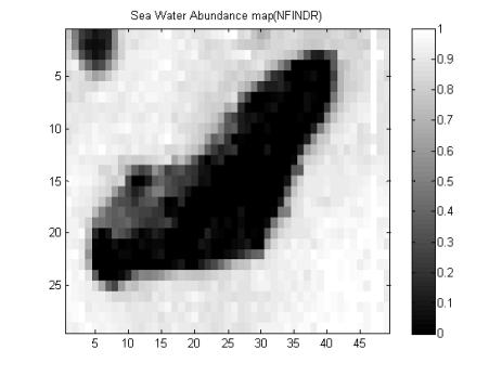
24 Combined Inversion and Unmixing at the Bottom (CIUB) Approach Use of subsurface remote sensing reflectance, r rs r rs C B dp 1 D u 1 Du 1 r = rs 1 exp κh + exp + κh Bρ + cos(θ w ) cos(θo cos(θ w ) cos(θo π Water Column Contribution Bottom Contribution Linear mixing model for the bottom albedo ρ = Sf S = [ ] ρ ρ ρ sand algae reef where x is the vector of abundances and all endmembers are normalized to 1 at 550nm
25 CIUB Approach (cont.) Work with the subsurface remote sensing reflectance ( ˆ) γˆ, f = = arg min γ,f arg min γ,f r rs b rˆ rs r ( γ, Sf ) rs ( γ) A( γ) r rs f Partially Linear Nonlinear Least Squares Problem
26 Two-Stage Simple Iterative Inversion Approach Initialization using Lee s approach Step 1: Abundance estimation fˆ = arg min γ,f ( γˆ ) A( γˆ ) Step2: Update optical properties, bathymetry and bottom albedo at 550nm 2 solving b( γ) A( γ) fˆ 2 γˆ = arg min γ 2 r b r rs rs f 2 2
27 HyCIAT: A Hyperspectral Coastal Image Analysis Tool

28 HyCIAT Toolbox

29 Visualization File Name Scrolling Through Bands
30 RGB Composite ( )


31 Results Optimization: Water Optical Properties, Bathymetry and Albedo at 550nm Backscattering Select Parameter Absorption Phytoplancton

32 Abundance Estimates Result Window: Sand Abundance Coral Abundance Select Endmember Algae Abundance RGB Composite


33 Fractional Plots: RGB Composite of Three Abundance Maps


34 Kaneohe Bay Kaneohe Bay: is in the north eastern side of the island of Oahu in Hawaii, is12.8 Km long and 4.3 Km broad, with a maximum depth in the bay of 12 m. Hyperspectral imagery was acquired in April of 2000 by AVIRIS. Hyperspectral image acquired using AVIRIS with 224 spectral bands was subset to 42 bands in the 0.4 to 0.8 µm range, it consists of an image already corrected for atmospheric and sunglint effects.

35 Measured Bottom Reflectance


36 Bathymetry CIUB: Depth SHOALS Depth
37 Bathymetry Comparison Depth CIUB Depth SHOALS


38 Water Parameters Backscattering 0 Phytoplancton Absorption


39 Abundance Maps Sand 0 Algae Coral 0


40 Fractional Map

41 Mission Coverage: Galileo - AISA Mission Overview


42 Preview of New Data Set


43 Conclusions Hyperspectral Remote Sensing has great potential to address problems in coastal remote sensing A software tool for coastal analysis has been developed MATLAB GUI tool provides simple environment for fast analysis Simple GUI makes algorithms accessible to a wider community
44 Acknowledgements This work was primarily supported by the Engineering Research Center Program of the National Science Foundation under Award Number EEC Partial support was also received from NASA throught few grants
REMOTE SENSING OF BENTHIC HABITATS IN SOUTHWESTERN PUERTO RICO
 REMOTE SENSING OF BENTHIC HABITATS IN SOUTHWESTERN PUERTO RICO Fernando Gilbes Santaella Dep. of Geology Roy Armstrong Dep. of Marine Sciences University of Puerto Rico at Mayagüez fernando.gilbes@upr.edu
Bottom Albedo Images to Improve Classification of Benthic Habitat Maps
 Bottom Albedo Images to Improve Classification of Benthic Habitat Maps William J Hernandez, Ph.D Post-Doctoral Researcher NOAA CREST University of Puerto Rico, Mayaguez, Puerto Rico, Global Science and
HYPERSPECTRAL REMOTE SENSING
 HYPERSPECTRAL REMOTE SENSING By Samuel Rosario Overview The Electromagnetic Spectrum Radiation Types MSI vs HIS Sensors Applications Image Analysis Software Feature Extraction Information Extraction 1
The MATLAB Hyperspectral Image Analysis Toolbox
 The MATLAB Hyperspectral Image Analysis Toolbox Samuel Rosario-Torres, Miguel Vélez-Reyes Phd. and Luis O. Jiménez Ph.D. Laboratory of Applied Remote Sensing and Imaging System University of Puerto Rico
Shallow-water Remote Sensing: Lecture 1: Overview
 Shallow-water Remote Sensing: Lecture 1: Overview Curtis Mobley Vice President for Science and Senior Scientist Sequoia Scientific, Inc. Bellevue, WA 98005 curtis.mobley@sequoiasci.com IOCCG Course Villefranche-sur-Mer,
Algorithm Acceleration for Geospatial Analysis
 Algorithm Acceleration for Geospatial Analysis GTC 2012 / May 14-18 / San Jose, CA James Goodman, PhD, PE President / CEO HySpeed Computing LLC jgoodman@hyspeedcomputing.com Matthew Sellitto & David Kaeli
Hyperspectral Remote Sensing
 Hyperspectral Remote Sensing Multi-spectral: Several comparatively wide spectral bands Hyperspectral: Many (could be hundreds) very narrow spectral bands GEOG 4110/5100 30 AVIRIS: Airborne Visible/Infrared
Challenges in detecting trend and seasonal changes in bathymetry derived from HICO imagery: a case study of Shark Bay, Western Australia
 Challenges in detecting trend and seasonal changes in bathymetry derived from HICO imagery: a case study of Shark Bay, Western Australia Rodrigo Garcia 1, Peter Fearns 1, Lachlan McKinna 1,2 1 Remote Sensing
SAMBUCA Semi-Analytical Model for Bathymetry, Un-mixing, and Concentration Assessment. Magnus Wettle and Vittorio Ernesto Brando
 SAMBUCA Semi-Analytical Model for Bathymetry, Un-mixing, and Concentration Assessment Magnus Wettle and Vittorio Ernesto Brando CSIRO Land and Water Science Report 22/06 July 2006 Copyright and Disclaimer
A Look-up-Table Approach to Inverting Remotely Sensed Ocean Color Data
 A Look-up-Table Approach to Inverting Remotely Sensed Ocean Color Data Curtis D. Mobley Sequoia Scientific, Inc. Westpark Technical Center 15317 NE 90th Street Redmond, WA 98052 phone: 425-867-2464 x 109
Copyright 2005 Society of Photo-Optical Instrumentation Engineers.
 Copyright 2005 Society of Photo-Optical Instrumentation Engineers. This paper was published in the Proceedings, SPIE Symposium on Defense & Security, 28 March 1 April, 2005, Orlando, FL, Conference 5806
ENVI Classic Tutorial: Multispectral Analysis of MASTER HDF Data 2
 ENVI Classic Tutorial: Multispectral Analysis of MASTER HDF Data Multispectral Analysis of MASTER HDF Data 2 Files Used in This Tutorial 2 Background 2 Shortwave Infrared (SWIR) Analysis 3 Opening the
Continued Development of the Look-up-table (LUT) Methodology For Interpretation of Remotely Sensed Ocean Color Data
 Methodology For Interpretation of Remotely Sensed Ocean Color Data") Continued Development of the Look-up-table (LUT) Methodology For Interpretation of Remotely Sensed Ocean Color Data Curtis D. Mobley Sequoia Scientific, Inc. 2700 Richards Road, Suite 107 Bellevue, WA
Continued Development of the Look-up-table (LUT) Methodology For Interpretation of Remotely Sensed Ocean Color Data Curtis D. Mobley Sequoia Scientific, Inc. 2700 Richards Road, Suite 107 Bellevue, WA
Continued Development of the Look-up-table (LUT) Methodology For Interpretation of Remotely Sensed Ocean Color Data
 Methodology For Interpretation of Remotely Sensed Ocean Color Data") Continued Development of the Look-up-table (LUT) Methodology For Interpretation of Remotely Sensed Ocean Color Data W. Paul Bissett Florida Environmental Research Institute 10500 University Center Dr.,
Continued Development of the Look-up-table (LUT) Methodology For Interpretation of Remotely Sensed Ocean Color Data W. Paul Bissett Florida Environmental Research Institute 10500 University Center Dr.,
AAIA PUBLICATIONS YEARS
 AAIA PUBLICATIONS YEARS 2000 2004 YEAR 00-01 V. Manian, R. Vasquez, and P. Katiyar, Texture Classification Using Logical Operators, IEEE Transactions on Image Processing, Vol. 9, No. 10, pp. 1693-1703,
CHALLENGES GLOBAL APPROACH TO:
 CHALLENGES GLOBAL APPROACH TO: SPECTRAL LIBRARIES(MACROPHYTES, MACRO_ALGAE, SEAGRASSES, MUD, SAND, RUBBLE, DETRITUS, BENTHIC MICRO_ALGAE PHYTOPLANKTON) INLAND BIO-OPTICAL DATABASES-OPEN SOURCE INLAND WATER
Water Column Correction for Coral Reef Studies by Remote Sensing
 Sensors 2014, 14, 16881-16931; doi:10.3390/s140916881 Review OPEN ACCESS sensors ISSN 1424-8220 www.mdpi.com/journal/sensors Water Column Correction for Coral Reef Studies by Remote Sensing Maria Laura
ENVI Tutorial: Geologic Hyperspectral Analysis
 ENVI Tutorial: Geologic Hyperspectral Analysis Table of Contents OVERVIEW OF THIS TUTORIAL...2 Objectives...2 s Used in This Tutorial...2 PROCESSING FLOW...3 GEOLOGIC HYPERSPECTRAL ANALYSIS...4 Overview
ENVI Tutorial: Vegetation Hyperspectral Analysis
 ENVI Tutorial: Vegetation Hyperspectral Analysis Table of Contents OVERVIEW OF THIS TUTORIAL...1 HyMap Processing Flow...4 VEGETATION HYPERSPECTRAL ANALYSIS...4 Examine the Jasper Ridge HyMap Radiance
Algorithm Comparison for Shallow-Water Remote Sensing
 DISTRIBUTION STATEMENT A: Approved for public release; distribution is unlimited. Algorithm Comparison for Shallow-Water Remote Sensing Curtis D. Mobley Sequoia Scientific, Inc. 2700 Richards Road, Suite
Multiple Optical Shallow Water Inversion Methods for Bathymetry, In-Water Optics, and Benthos Mapping : How Do They Compare?
 Multiple Optical Shallow Water Inversion Methods for Bathymetry, In-Water Optics, and Benthos Mapping : How Do They Compare? Dekker A.G. (1,2), *Phinn S.R. (2), Anstee J. (1), Bissett P. (3), Brando V.E.
Analysis of Hyperspectral Data for Coastal Bathymetry and Water Quality
 Analysis of Hyperspectral Data for Coastal Bathymetry and Water Quality William Philpot Cornell University 453 Hollister Hall, Ithaca, NY 14853 phone: (607) 255-0801 fax: (607) 255-9004 e-mail: wdp2@cornell.edu
Optimizing Machine Learning Algorithms for Hyperspectral Very Shallow Water (VSW) Products
 Products") Optimizing Machine Learning Algorithms for Hyperspectral Very Shallow Water (VSW) Products W. Paul Bissett Florida Environmental Research Institute 10500 University Center Dr. Suite 140 Tampa, FL 33612
Optimizing Machine Learning Algorithms for Hyperspectral Very Shallow Water (VSW) Products W. Paul Bissett Florida Environmental Research Institute 10500 University Center Dr. Suite 140 Tampa, FL 33612
REMOTE SENSING OF BENTHIC HABITATS IN SOUTHWESTERN PUERTO RICO JEANNETTE ARCE ARCE
 REMOTE SENSING OF BENTHIC HABITATS IN SOUTHWESTERN PUERTO RICO By JEANNETTE ARCE ARCE Thesis submitted in partial fulfillment for the requirements for the degree of Approved by: MASTER IN SCIENCE In Geology
Remote Sensing Introduction to the course
 Remote Sensing Introduction to the course Remote Sensing (Prof. L. Biagi) Exploitation of remotely assessed data for information retrieval Data: Digital images of the Earth, obtained by sensors recording
Lecture 7. Spectral Unmixing. Summary. Mixtures in Remote Sensing
 Lecture 7 Spectral Unmixing Summary This lecture will introduce you to the concepts of linear spectral mixing. This methods is sometimes also called: Spectral Mixture Analysis (SMA: Wessman et al 1997)
Overview of the EnMAP Imaging Spectroscopy Mission
 Overview of the EnMAP Imaging Spectroscopy Mission L. Guanter, H. Kaufmann, K. Segl, S. Foerster, T. Storch, A. Mueller, U. Heiden, M. Bachmann, G. Rossner, C. Chlebek, S. Fischer, B. Sang, the EnMAP Science
CRISM (Compact Reconnaissance Imaging Spectrometer for Mars) on MRO. Calibration Upgrade, version 2 to 3
 on MRO. Calibration Upgrade, version 2 to 3") CRISM (Compact Reconnaissance Imaging Spectrometer for Mars) on MRO Calibration Upgrade, version 2 to 3 Dave Humm Applied Physics Laboratory, Laurel, MD 20723 18 March 2012 1 Calibration Overview 2 Simplified
CRISM (Compact Reconnaissance Imaging Spectrometer for Mars) on MRO Calibration Upgrade, version 2 to 3 Dave Humm Applied Physics Laboratory, Laurel, MD 20723 18 March 2012 1 Calibration Overview 2 Simplified
Retrieval of Surface Reflectance and LAI Mapping with Data from ALI, Hyperion and AVIRIS
 Retrieval of Surface Reflectance and LAI Mapping with Data from ALI, Hyperion and AVIRIS P. Gong 1, G. Biging 1, R. Pu 1, and M. R. Larrieu 2 1 Center for Assessment and Monitoring of Forest and Environmental
Ocean color algorithms in optically shallow waters: Limitations and improvements
 Ocean color algorithms in optically shallow waters: Limitations and improvements Kendall L. Carder *a, Jennifer P. Cannizzaro a, Zhongping Lee b a University of South Florida, 140 7 th Ave. S, St. Petersburg,
TOA RADIANCE SIMULATOR FOR THE NEW HYPERSPECTRAL MISSIONS: STORE (SIMULATOR OF TOA RADIANCE)
") TOA RADIANCE SIMULATOR FOR THE NEW HYPERSPECTRAL MISSIONS: STORE (SIMULATOR OF TOA RADIANCE) Malvina Silvestri Istituto Nazionale di Geofisica e Vulcanologia In the frame of the Italian Space Agency (ASI)
TOA RADIANCE SIMULATOR FOR THE NEW HYPERSPECTRAL MISSIONS: STORE (SIMULATOR OF TOA RADIANCE) Malvina Silvestri Istituto Nazionale di Geofisica e Vulcanologia In the frame of the Italian Space Agency (ASI)
Uncertainties in the Products of Ocean-Colour Remote Sensing
 Chapter 3 Uncertainties in the Products of Ocean-Colour Remote Sensing Emmanuel Boss and Stephane Maritorena Data products retrieved from the inversion of in situ or remotely sensed oceancolour data are
Three dimensional light environment: Coral reefs and seagrasses
 Three dimensional light environment: Coral reefs and seagrasses 1) Three-dimensional radiative transfer modelling 2) Photobiology in submerged canopies 3) Sun glint correction of high spatial resolution
ENVI Classic Tutorial: Basic Hyperspectral Analysis
 ENVI Classic Tutorial: Basic Hyperspectral Analysis Basic Hyperspectral Analysis 2 Files Used in this Tutorial 2 Define ROIs 3 Load AVIRIS Data 3 Create and Restore ROIs 3 Extract Mean Spectra from ROIs
Crop Types Classification By Hyperion Data And Unmixing Algorithm
 Crop Types Classification By Hyperion Data And Unmixing Algorithm H. FAHIMNEJAD 1, S.R. SOOFBAF 2, A. ALIMOHAMMADI 3, M. J. VALADAN ZOEJ 4 Geodesy and Geomatic Faculty, K.N.Toosi University of Technology,
SENSITIVITY ANALYSIS OF SEMI-ANALYTICAL MODELS OF DIFFUSE ATTENTUATION OF DOWNWELLING IRRADIANCE IN LAKE BALATON
 SENSITIVITY ANALYSIS OF SEMI-ANALYTICAL MODELS OF DIFFUSE ATTENTUATION OF DOWNWELLING IRRADIANCE IN LAKE BALATON Van der Zande D. (1), Blaas M. (2), Nechad B. (1) (1) Royal Belgian Institute of Natural
Analisi di immagini iperspettrali satellitari multitemporali: metodi ed applicazioni
 Analisi di immagini iperspettrali satellitari multitemporali: metodi ed applicazioni E-mail: bovolo@fbk.eu Web page: http://rsde.fbk.eu Outline 1 Multitemporal image analysis 2 Multitemporal images pre-processing
Remote Sensing of Environment
 RSE-07469; No of Pages 6 Remote Sensing of Environment xxx (2009) xxx xxx Contents lists available at ScienceDirect Remote Sensing of Environment journal homepage: www.elsevier.com/locate/rse Efficient
Better detection and discrimination of seagrasses using fused bathymetric lidar and hyperspectral data
 Better detection and discrimination of seagrasses using fused bathymetric lidar and hyperspectral data Bruce Sabol and Molly Reif US Army Engineer Research and Development Center, Environmental Laboratory
SEA BOTTOM MAPPING FROM ALOS AVNIR-2 AND QUICKBIRD SATELLITE DATA
 SEA BOTTOM MAPPING FROM ALOS AVNIR-2 AND QUICKBIRD SATELLITE DATA Mohd Ibrahim Seeni Mohd, Nurul Nadiah Yahya, Samsudin Ahmad Faculty of Geoinformation and Real Estate, Universiti Teknologi Malaysia, 81310
ENVI Tutorial: Basic Hyperspectral Analysis
 ENVI Tutorial: Basic Hyperspectral Analysis Table of Contents OVERVIEW OF THIS TUTORIAL...2 DEFINE ROIS...3 Load AVIRIS Data...3 Create and Restore ROIs...3 Extract Mean Spectra from ROIs...4 DISCRIMINATE
Testing Hyperspectral Remote Sensing Monitoring Techniques for Geological CO 2 Storage at Natural Seeps
 Testing Hyperspectral Remote Sensing Monitoring Techniques for Geological CO 2 Storage at Natural Seeps Luke Bateson Clare Fleming Jonathan Pearce British Geological Survey In what ways can EO help with
2017 Summer Course on Optical Oceanography and Ocean Color Remote Sensing. Introduction to Remote Sensing
 2017 Summer Course on Optical Oceanography and Ocean Color Remote Sensing Introduction to Remote Sensing Curtis Mobley Delivered at the Darling Marine Center, University of Maine July 2017 Copyright 2017
Diffraction gratings. e.g., CDs and DVDs
 Diffraction gratings e.g., CDs and DVDs Diffraction gratings Constructive interference where: sinθ = m*λ / d (If d > λ) Single-slit diffraction 1.22 * λ / d Grating, plus order-sorting filters on detector
Hyperspectral Unmixing on GPUs and Multi-Core Processors: A Comparison
 Hyperspectral Unmixing on GPUs and Multi-Core Processors: A Comparison Dept. of Mechanical and Environmental Informatics Kimura-Nakao lab. Uehara Daiki Today s outline 1. Self-introduction 2. Basics of
GEOBIA for ArcGIS (presentation) Jacek Urbanski
 Jacek Urbanski") GEOBIA for ArcGIS (presentation) Jacek Urbanski INTEGRATION OF GEOBIA WITH GIS FOR SEMI-AUTOMATIC LAND COVER MAPPING FROM LANDSAT 8 IMAGERY Presented at 5th GEOBIA conference 21 24 May in Thessaloniki.
GEOBIA for ArcGIS (presentation) Jacek Urbanski INTEGRATION OF GEOBIA WITH GIS FOR SEMI-AUTOMATIC LAND COVER MAPPING FROM LANDSAT 8 IMAGERY Presented at 5th GEOBIA conference 21 24 May in Thessaloniki.
DERIVATIVE BASED HYPERSPECRAL ALGORITHM FOR BATHYMETRIC MAPPING
 DERIVATIVE BASED HYPERSPECRAL ALGORITHM FOR BATHYMETRIC MAPPING David D. R. Kohler, William D. Philpot, Civil and Environmental Engineering, Cornell University Ithaca, NY14853 Curtis D. Mobley Sequoia
Unsupervised and Self-taught Learning for Remote Sensing Image Analysis
 Unsupervised and Self-taught Learning for Remote Sensing Image Analysis Ribana Roscher Institute of Geodesy and Geoinformation, Remote Sensing Group, University of Bonn 1 The Changing Earth https://earthengine.google.com/timelapse/
Bread Water Content Measurement Based on Hyperspectral Imaging
 93 Bread Water Content Measurement Based on Hyperspectral Imaging Zhi Liu 1, Flemming Møller 1.2 1 Department of Informatics and Mathematical Modelling, Technical University of Denmark, Kgs. Lyngby, Denmark
Hyperspectral Chemical Imaging: principles and Chemometrics.
 Hyperspectral Chemical Imaging: principles and Chemometrics aoife.gowen@ucd.ie University College Dublin University College Dublin 1,596 PhD students 6,17 international students 8,54 graduate students
Develop proxy VIIRS Ocean Color remotesensing reflectance from MODIS
 Develop proxy VIIRS Ocean Color remotesensing reflectance from ODIS 1) Define a VIIRS Proxy Data Stream 2) Define the required in situ data stream for Cal/Val 3) Tuning of algorithms and LUTS (Vicarious
Visualization of High-dimensional Remote- Sensing Data Products
 Visualization of High-dimensional Remote- Sensing Data Products An Innovative Graduate Student Research Proposal Principle Innovator Hongqin Zhang, Graduate Student Chester F. Carlson Center for Image
Spectral Classification
 Spectral Classification Spectral Classification Supervised versus Unsupervised Classification n Unsupervised Classes are determined by the computer. Also referred to as clustering n Supervised Classes
Improved Global Ocean Color using POLYMER Algorithm
 Improved Global Ocean Color using POLYMER Algorithm François Steinmetz 1 Didier Ramon 1 Pierre-Yves Deschamps 1 Jacques Stum 2 1 Hygeos 2 CLS June 29, 2010 ESA Living Planet Symposium, Bergen, Norway c
AN IMPROVED ENDMEMBER EXTRACTION ALGORITHM BY INVERSING LINEAR MIXING MODEL
 AN IMPROVED ENDMEMBER EXTRACTION ALGORITHM BY INVERSING LINEAR MIXING MODEL LI Shanshan, TIAN Qingjiu International Institute for Earth System Science, Nanjing University, Nanjing, 210093, China lisslee@163.com
Spectral imagers for nanosatellites
 VTT TECHNICAL RESEARCH CENTRE OF FINLAND LTD Spectral imagers for nanosatellites Finnish Satellite Workshop 2018 Antti Näsilä VTT Microspectrometers Fabry-Perot (FPI) technology for miniaturizing optical
ENVI Classic Tutorial: Introduction to Hyperspectral Data 2
 ENVI Classic Tutorial: Introduction to Hyperspectral Data Introduction to Hyperspectral Data 2 Files Used in this Tutorial 2 Background: Imaging Spectrometry 4 Introduction to Spectral Processing in ENVI
Atmospheric correction of hyperspectral ocean color sensors: application to HICO
 Atmospheric correction of hyperspectral ocean color sensors: application to HICO Amir Ibrahim NASA GSFC / USRA Bryan Franz, Zia Ahmad, Kirk knobelspiesse (NASA GSFC), and Bo-Cai Gao (NRL) Remote sensing
Cloud masking in remotely sensed hyperspectral images using linear and nonlinear spectral mixture analysis
 Cloud masking in remotely sensed hyperspectral images using linear and nonlinear spectral mixture analysis J. Amorós-López, L. Gómez-Chova, A. Plaza, J. Plaza, J. Calpe, L. Alonso, J. Moreno () GPDS, Dept.
Accepted Manuscript. Spatio-Spectral Fusion of Satellite Images based on Dictionary-pair Learning. Huihui Song, Bo Huang, Kaihua Zhang, Hankui Zhang
 Accepted Manuscript Spatio-Spectral Fusion of Satellite Images based on Dictionary-pair Learning Huihui Song, Bo Huang, Kaihua Zhang, Hankui Zhang PII: S1566-535(13)00085-7 DOI: http://dx.doi.org/10.1016/j.inffus.013.08.005
End-to-End Simulation of Sentinel-2 Data with Emphasis on Atmospheric Correction Methods
 End-to-End Simulation of Sentinel-2 Data with Emphasis on Atmospheric Correction Methods Luis Guanter 1, Karl Segl 2, Hermann Kaufmann 2 (1) Institute for Space Sciences, Freie Universität Berlin, Germany
ATMOSPHERIC CORRECTION ITERATIVE METHOD FOR HIGH RESOLUTION AEROSPACE IMAGING SPECTROMETERS
 ATMOSPHERIC CORRECTION ITERATIVE METHOD FOR HIGH RESOLUTION AEROSPACE IMAGING SPECTROMETERS Alessandro Barducci, Donatella Guzzi, Paolo Marcoionni, Ivan Pippi * CNR IFAC Via Madonna del Piano 10, 50019
EVALUATION OF CONVENTIONAL DIGITAL CAMERA SCENES FOR THEMATIC INFORMATION EXTRACTION ABSTRACT
 EVALUATION OF CONVENTIONAL DIGITAL CAMERA SCENES FOR THEMATIC INFORMATION EXTRACTION H. S. Lim, M. Z. MatJafri and K. Abdullah School of Physics Universiti Sains Malaysia, 11800 Penang ABSTRACT A study
Modeling reflectance and transmittance of leaves in the µm domain: PROSPECT-VISIR
 Modeling reflectance and transmittance of leaves in the 0.4-5.7 µm domain: PROSPECT-VISIR F. Gerber 1,2, R. Marion 1, S. Jacquemoud 2, A. Olioso 3 et S. Fabre 4 1 CEA/DASE/Télédétection, Surveillance,
Optimizing LUT-based RTM inversion for retrieval of biophysical parameters
 Optimizing LUT-based RTM inversion for retrieval of biophysical parameters Jochem Verrelst 1, Juan Pablo Rivera 1, Anna Leoneko 2, Luis Alonso 1, Jose Moreno 1 1 : University of Valencia, Spain 2 : Swansea
Ocean Products and Atmospheric Removal in APS
 Oregon State Ocean Products and Atmospheric Removal in APS David Lewis Oceanography Division Naval Research Laboratory Stennis Space Center, Mississipp david.lewis@nrlssc.navy.mil Contributors: David Lewis
Generation of remotely sensed reference data using low altitude, high spatial resolution hyperspectral imagery
 Generation of remotely sensed reference data using low altitude, high spatial resolution hyperspectral imagery McKay D. Williams, Jan van Aardt, and John P. Kerekes Chester F. Carlson Center for Imaging
New Algorithm for MODIS chlorophyll Fluorescence Height Retrieval: performance and comparison with the current product
 New Algorithm for MODIS chlorophyll Fluorescence Height Retrieval: performance and comparison with the current product I. Ioannou, J. Zhou, A. Gilerson, B. Gross, F. Moshary and S. Ahmed Optical Remote
Ocean Optics Inversion Algorithm
 Ocean Optics Inversion Algorithm N. J. McCormick 1 and Eric Rehm 2 1 University of Washington Department of Mechanical Engineering Seattle, WA 98195-26 mccor@u.washington.edu 2 University of Washington
GEOMETRY AND RADIATION QUALITY EVALUATION OF GF-1 AND GF-2 SATELLITE IMAGERY. Yong Xie
 Prepared by CNSA Agenda Item: WG.3 GEOMETRY AND RADIATION QUALITY EVALUATION OF GF-1 AND GF-2 SATELLITE IMAGERY Yong Xie Institute of Remote Sensing and Digital Earth, Chinese Academy of Science GF-1 and
NAVAL POSTGRADUATE SCHOOL THESIS
 NAVAL POSTGRADUATE SCHOOL MONTEREY, CALIFORNIA THESIS EVALUATION OF SUN GLINT CORRECTION ALGORITHMS FOR HIGH-SPATIAL RESOLUTION HYPERSPECTRAL IMAGERY by Chad I. Miller September 2012 Thesis Advisor: Second
Development of datasets and algorithms for hyperspectral IOP products from the PACE ocean color measurements
 Development of datasets and algorithms for hyperspectral IOP products from the PACE ocean color measurements Principal Investigator: Co-Investigators: Collaborator: ZhongPing Lee Michael Ondrusek NOAA/NESDIS/STAR
Spectral Super-Resolution of Hyperspectral Imagery Using Reweighted l 1 Spatial Filtering
 Spectral Super-Resolution of Hyperspectral Imagery Using Reweighted l 1 Spatial Filtering Adam S. Charles, Student Member, IEEE, and Christopher J. Rozell, Senior Member, IEEE 1 Abstract Sparsity-based
Prof. Vidya Manian Dept. of Electrical l and Comptuer Engineering. INEL6007(Spring 2010) ECE, UPRM
 ECE, UPRM") Inel 6007 Introduction to Remote Sensing Chapter 5 Spectral Transforms Prof. Vidya Manian Dept. of Electrical l and Comptuer Engineering Chapter 5-1 MSI Representation Image Space: Spatial information
Inel 6007 Introduction to Remote Sensing Chapter 5 Spectral Transforms Prof. Vidya Manian Dept. of Electrical l and Comptuer Engineering Chapter 5-1 MSI Representation Image Space: Spatial information
REMOTE SENSING OF VERTICAL IOP STRUCTURE
 REMOTE SENSING OF VERTICAL IOP STRUCTURE W. Scott Pegau College of Oceanic and Atmospheric Sciences Ocean. Admin. Bldg. 104 Oregon State University Corvallis, OR 97331-5503 Phone: (541) 737-5229 fax: (541)
Prototyping GOES-R Albedo Algorithm Based on MODIS Data Tao He a, Shunlin Liang a, Dongdong Wang a
 Prototyping GOES-R Albedo Algorithm Based on MODIS Data Tao He a, Shunlin Liang a, Dongdong Wang a a. Department of Geography, University of Maryland, College Park, USA Hongyi Wu b b. University of Electronic
TOTAL SUSPENDED MATTER MAPS FROM CHRIS IMAGERY OF A SMALL INLAND WATER BODY IN OOSTENDE (BELGIUM)
") TOTAL SUSPENDED MATTER MAPS FROM IMAGERY OF A SMALL INLAND WATER BODY IN OOSTENDE (BELGIUM) Barbara Van Mol (1) and Kevin Ruddick (1) (1) Management Unit of the North Sea Mathematical Models (MUMM), Royal
TOTAL SUSPENDED MATTER MAPS FROM IMAGERY OF A SMALL INLAND WATER BODY IN OOSTENDE (BELGIUM) Barbara Van Mol (1) and Kevin Ruddick (1) (1) Management Unit of the North Sea Mathematical Models (MUMM), Royal
Defining Remote Sensing
 Defining Remote Sensing Remote Sensing is a technology for sampling electromagnetic radiation to acquire and interpret non-immediate geospatial data from which to extract information about features, objects,
Infrared Scene Simulation for Chemical Standoff Detection System Evaluation
 Infrared Scene Simulation for Chemical Standoff Detection System Evaluation Peter Mantica, Chris Lietzke, Jer Zimmermann ITT Industries, Advanced Engineering and Sciences Division Fort Wayne, Indiana Fran
Seawater reflectance in the near-ir
 Seawater reflectance in the near-ir Maéva DORON David DOXARAN Simon BELANGER Marcel BABIN Laboratoire d'océanographie de Villefranche Seawater Reflectance in the Near-IR Doron, Doxaran, Bélanger & Babin
Comparison of Full-resolution S-NPP CrIS Radiance with Radiative Transfer Model
 Comparison of Full-resolution S-NPP CrIS Radiance with Radiative Transfer Model Xu Liu NASA Langley Research Center W. Wu, S. Kizer, H. Li, D. K. Zhou, and A. M. Larar Acknowledgements Yong Han NOAA STAR
Rochester Institute of Technology, 54 Lomb Memorial Drive, Rochester, NY USA 14623; ABSTRACT 1. INTRODUCTION
 A Comparison of Real and Simulated Airborne Multisensor Imagery Kevin Bloechl a, Chris De Angelis a, Michael Gartley a, John Kerekes a, C. Eric Nance b a Digital Imaging and Remote Sensing Laboratory,
Performance Optimizations for an Automatic Target Generation Process in Hyperspectral Analysis
 Performance Optimizations for an Automatic Target Generation Process in Hyperspectral Analysis Fernando Sierra-Pajuelo 1, Abel Paz-Gallardo 2, Centro Extremeño de Tecnologías Avanzadas C. Sola, 1. Trujillo,
Analysis of the In-Water and Sky Radiance Distribution Data Acquired During the Radyo Project
 DISTRIBUTION STATEMENT A. Approved for public release; distribution is unlimited. Analysis of the In-Water and Sky Radiance Distribution Data Acquired During the Radyo Project Kenneth J. Voss Physics Department,
Editor: Steven C. Reising
 Editor: Steven C. Reising See page 3 for a description of images. Cumulative Issue #121 December 2001 ISSN 0161-7869 UNIVERSITY PROFILE The Laboratory for Applied Remote Sensing and Image Processing at
Retrieval of optical and microphysical properties of ocean constituents using polarimetric remote sensing
 Retrieval of optical and microphysical properties of ocean constituents using polarimetric remote sensing Presented by: Amir Ibrahim Optical Remote Sensing Laboratory, The City College of the City University
9/14/2011. Contents. Lecture 3: Spatial Data Acquisition in GIS. Dr. Bo Wu Learning Outcomes. Data Input Stream in GIS
 Contents Lecture 3: Spatial Data Acquisition in GIS Dr. Bo Wu lsbowu@polyu.edu.hk 1. Learning outcomes. Data acquisition: Manual digitization 3. Data acquisition: Field survey 4. Data acquisition: Remote
An Innovative Satellite SO 2 and HCHO Retrieval Algorithm based on Principal Component Analysis: Contribution to the Sentinel-5P Mission
 An Innovative Satellite SO 2 and HCHO Retrieval Algorithm based on Principal Component Analysis: Contribution to the Sentinel-5P Mission Nickolay Krotkov 1, Can Li 1, 2, Joanna Joiner 1, Vitali Fioletov
CHRIS PROBA instrument
 CHRIS PROBA instrument Wout Verhoef ITC, The Netherlands verhoef @itc.nl 29 June 2009, D1L5 Contents Satellite and instrument Images Multi-angular analysis Toolbox CHRIS-PROBA PROBA-CHRIS Project for On-Board
Hyperspectral Image Enhancement Based on Sensor Simulation and Vector Decomposition
 Hyperspectral Image Enhancement Based on Sensor Simulation and Vector Decomposition Ankush Khandelwal Lab for Spatial Informatics International Institute of Information Technology Hyderabad, India ankush.khandelwal@research.iiit.ac.in
ENMAP RADIOMETRIC INFLIGHT CALIBRATION
 ENMAP RADIOMETRIC INFLIGHT CALIBRATION Harald Krawczyk 1, Birgit Gerasch 1, Thomas Walzel 1, Tobias Storch 1, Rupert Müller 1, Bernhard Sang 2, Christian Chlebek 3 1 Earth Observation Center (EOC), German
5: COMPENSATING FOR VARIABLE WATER DEPTH TO IMPROVE MAPPING OF UNDERWATER HABITATS: WHY IT IS NECESSARY. Aim of Lesson. Objectives
 Lesson 5: Compensating for variable water depth 5: COMPENSATING FOR VARIABLE WATER DEPTH TO IMPROVE MAPPING OF UNDERWATER HABITATS: WHY IT IS NECESSARY Aim of Lesson To learn how to carry out "depth-invariant"
GIS ETM * IKONOS .IKONOS :
 GIS 389 Vol.2, No.2, Summer 200 03-4 Iranian Remote Sensing & GIS IKONOS ETM+ 5 4 3 2 *..2.3.4.5 390/4/28 : 389/2/2 : ETM *.... ( ) ( ). (IKONOS ) ( ). IKONOS 0/02 0/0 ).. ( ETM+ 0/02 IKONOS 0/03.IKONOS
Update on Pre-Cursor Calibration Analysis of Sentinel 2. Dennis Helder Nischal Mishra Larry Leigh Dave Aaron
 Update on Pre-Cursor Calibration Analysis of Sentinel 2 Dennis Helder Nischal Mishra Larry Leigh Dave Aaron Background The value of Sentinel-2 data, to the Landsat world, will be entirely dependent on
Classify Multi-Spectral Data Classify Geologic Terrains on Venus Apply Multi-Variate Statistics
 Classify Multi-Spectral Data Classify Geologic Terrains on Venus Apply Multi-Variate Statistics Operations What Do I Need? Classify Merge Combine Cross Scan Score Warp Respace Cover Subscene Rotate Translators
Current Status of Hyperspectral Imager Suite (HISUI)
") IGARSS 2014 July 13-18, 2014, Québec, Canada Current Status of Hyperspectral Imager Suite (HISUI) Jadeite Kingfisher Tsuneo Matsunaga 1, Akira Iwasaki 2, Satoshi Tsuchida 3, Jun Tanii 4, Osamu Kashimura
IGARSS 2014 July 13-18, 2014, Québec, Canada Current Status of Hyperspectral Imager Suite (HISUI) Jadeite Kingfisher Tsuneo Matsunaga 1, Akira Iwasaki 2, Satoshi Tsuchida 3, Jun Tanii 4, Osamu Kashimura
AISASYSTEMS PRODUCE MORE WITH LESS
 AISASYSTEMS PRODUCE MORE WITH LESS AISASYSTEMS SPECIM s AISA systems are state-of-the-art airborne hyperspectral imaging solutions covering the VNIR, NIR, SWIR and LWIR spectral ranges. The sensors unbeatable
2017 Summer Course Optical Oceanography and Ocean Color Remote Sensing. Overview of HydroLight and EcoLight
 2017 Summer Course Optical Oceanography and Ocean Color Remote Sensing Curtis Mobley Overview of HydroLight and EcoLight Darling Marine Center, University of Maine July 2017 Copyright 2017 by Curtis D.
Estimation Of Chlorophyll-A Concentrations Using Field Spectral Measurement And Multi-source Satellite Data In Lake Qiaodao, China (Project ID :10668)
") Estimation Of Chlorophyll-A Concentrations Using Field Spectral Measurement And Multi-source Satellite Data In Lake Qiaodao, China (Project ID :10668) Prof. Gong Jianhua, P.I. (China) Dr. Apostolos Sarris,
Estimation Of Chlorophyll-A Concentrations Using Field Spectral Measurement And Multi-source Satellite Data In Lake Qiaodao, China (Project ID :10668) Prof. Gong Jianhua, P.I. (China) Dr. Apostolos Sarris,
!"#$%&'()'*+,-.%/'01)2)' 333)45%6)6+&"4.%-7)#89:;7+,-.%'
'*+,-.%/'01)2)' 333)45%6)6+&4.%-7)#89:;7+,-.%'") !"#$%&'()'*+,-.%/'01)2)' 333)45%6)6+&"4.%-7)#89:;7+,-.%' !"#$%&#$'(&)*#$*+,-$!! '5#4+&85?'!! 1""@A::333)B+9"9,#)4+6:3%"41CDE2FG!H691(4=I$#%"97#E7#.%"#8'' ."+*$(/$'),*(/0#1*2+,3$!! 2-5@#75-+&'-5'"1#'#J#4"'31#7#',.9#'.-K1"'-5'7#$7%4"#8'6+7#'"1%&'7#8'.-K1"'
!"#$%&'()'*+,-.%/'01)2)' 333)45%6)6+&"4.%-7)#89:;7+,-.%' !"#$%&#$'(&)*#$*+,-$!! '5#4+&85?'!! 1""@A::333)B+9"9,#)4+6:3%"41CDE2FG!H691(4=I$#%"97#E7#.%"#8'' ."+*$(/$'),*(/0#1*2+,3$!! 2-5@#75-+&'-5'"1#'#J#4"'31#7#',.9#'.-K1"'-5'7#$7%4"#8'6+7#'"1%&'7#8'.-K1"'