Terrestrial radar and laser scanning for deformation monitoring: first steps towards assisted radar scanning
|
|
|
- Annice Stone
- 5 years ago
- Views:
Transcription


1 Terrestrial radar and laser scanning for deformation monitoring: first steps towards assisted radar scanning Daniel Wujanz 1, Frank Neitzel 1, H.P. Hebel 2, J. Linke 2, W. Busch 2 1 Chair of Geodesy and Adjustment Theory, Technische Universität Berlin, Germany 2 Chair of Mine Surveying and Geoinformation, Technische Universität Clausthal Vertical Geology Conference 2014 Université de Lausanne


 Terrestrial or ground based")
2 Sensor fusion for laminar deformation monitoring 3D-Acquisition of an area of interest at spatial and temporal continuity Aim of the Engineering Geodesy section (German Geodetic Commission -DGK) Terrestrial Laser Scanning (TLS) Terrestrial or ground based RADAR systems (GB-RADAR) Slide 2
3 TLS vs. GB-RADAR TLS Advantage Absolute approach Spatially laminar quasicontinuity High range Problems Sequential data acquisition Poor / unknown stochastic models Too simplified post processing software GB- RADAR Simultaneous and high frequent data acquisition High range and precision for geometrical changes (depth) Laminar continuity Ambiguous for larger deformations Complex post processing Linked to one standpoint Low spatial resolution Slide 3


4 Aim of this investigation Laminar monitoring Terrestrial Laser scanning GB-RADAR Complete picture of an areal: Spatial and temporal continuity Slide 4

5 In this talk Comparative investigations Introduction of the test case Introduction of the applied instrumentation Transformation into a common coordinate system of results for comparative reasons Data fusion Presentation of agb-radar Combined usage of TLS and GB-RADAR data Slide 5


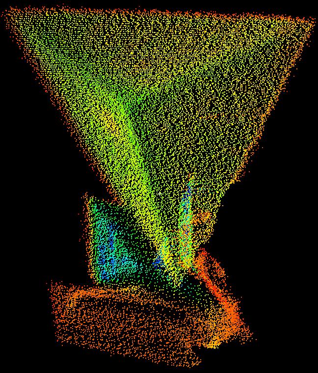
6 Description of the test case Quarry in secondary mountains Harz Slide 6


7 Description of the test case Quarry in secondary mountains Harz Acquisition of a reference epoch Five successive epochs including controlled changes Deformation monitoring with TLS and GB-RADAR Is the GB-RADAR system capable to identify the occuring deformations? Slide 7
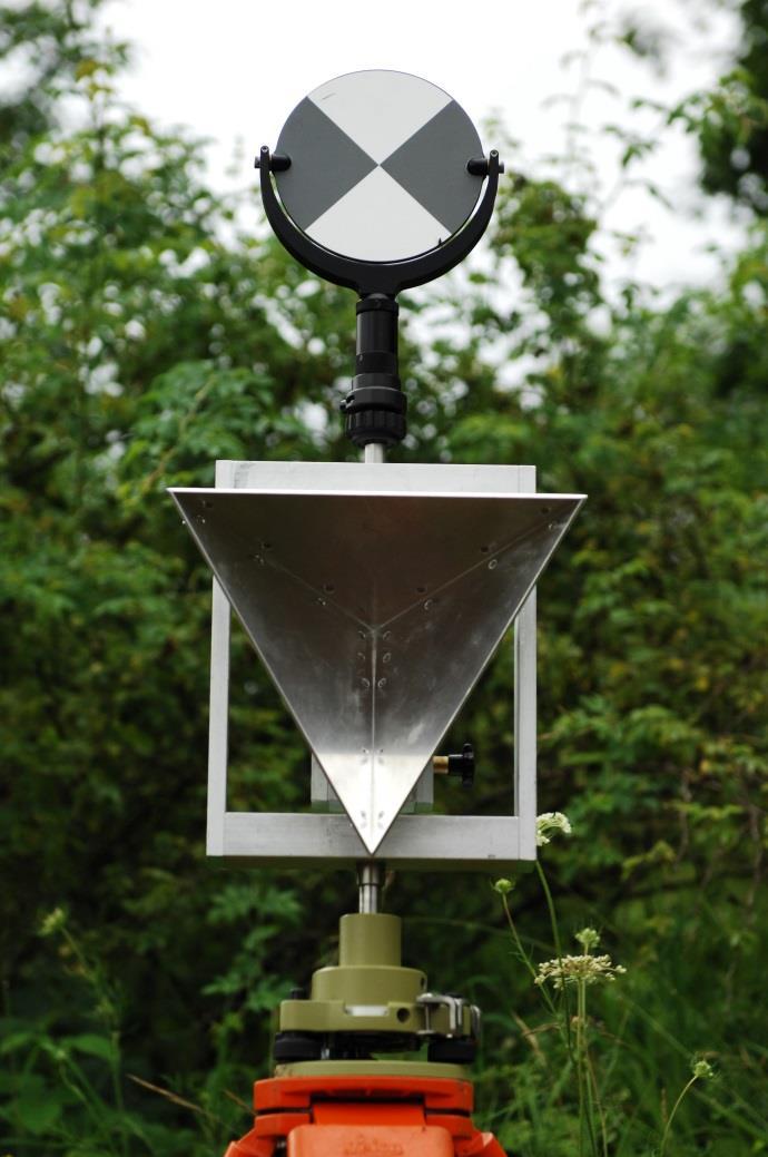
8 Description of the instruments Radar scanner GPRI-2 (TU Clausthal) Leica Scanstation C10 (TU Berlin) Reach up to 6 km Scan rate: 10 / s Reach up to 300 m Scan rate: up to pts / s Field of view: 360 horizontal 60 vertical Resolution: 0.75 m in line of sight 8 mrad in rotational direction Field of view: 360 horizontal 270 vertical Accuracy: 6 mm (within 50 m) Accuracy: under 1 mm Slide 8
9 Data acquisition Slide 9
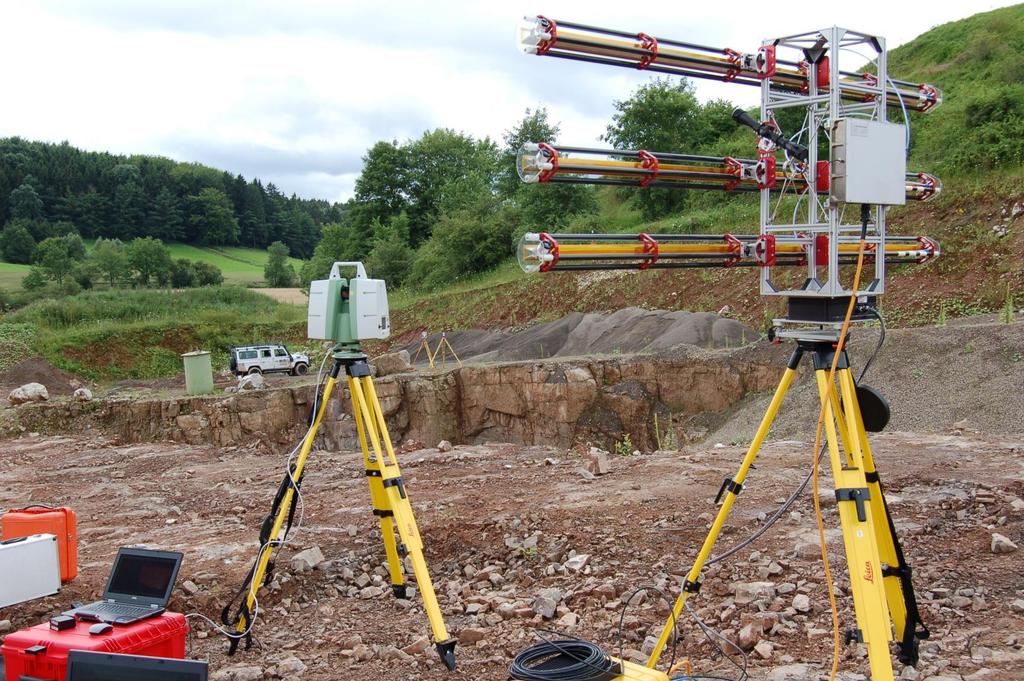
10 Data acquisition Slide 10

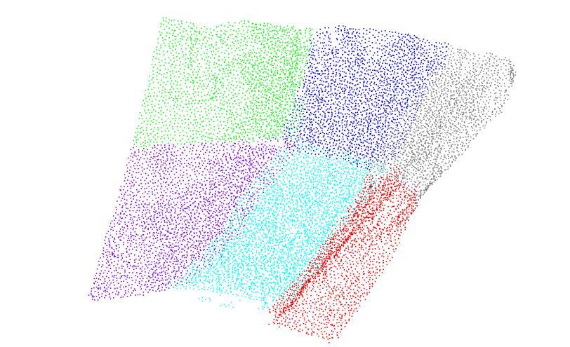
11 Data fusion Slide 11
12 Data fusion Slide 12


13 Data fusion Slide 13


14 Data fusion Conversion of TLS point cloud Triangulation of reference epoch Triangular mesh TLS-based deformation monitoring Monitoring in LOS Assignment of TLS points to RADAR pixels Slide 14

15 Data fusion Conversion of TLS point cloud Triangulation of reference epoch Triangular mesh TLS-based deformation monitoring Monitoring in LOS Assignment of TLS points to RADAR pixels Averaging of all TLS deformation vectors within a RADAR pixel Comparison between TRS and TLS is realisable Slide 15


16 Comparison between TLS and TRS Area of interest without artificial geometric changes Slide 16

 LEICA GEOSYSTEMS ZOLLER + FRÖHLICH")
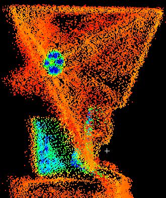
17 Comparison between TLS and TRS Area of interest with artificial geometric changes Occurance of phase unwrapping (amiguity effects) LEICA GEOSYSTEMS ZOLLER + FRÖHLICH Slide 17
18 Fusion of TLS and TRS Assisted RADAR agb-radar Conversion of geometric changes based on TLS into phases: L 2 L 2 r Computation of that lies between +π and π: mod L L Correction of measured phase values of the TRS: new R L Solution of ambiguities by usage of TLS data Slide 18
19 Results agb-radar Area of interest with artificial geometric changes Slide 19
 High frequency of RADAR-scanning agb-radar allows to interrupt RADAR campaigns in permanent monitoring processes")
20 Conclusion: agb-radar Geometric changes within area of interest caused phase-unwrapping ambiguities TLS data has been successfully used to solve these ambiguities assisted GB-RADAR (agb-radar) Update of RADAR-pixels ONLY in case of significant TLS-deformation (local update of DEM) High frequency of RADAR-scanning agb-radar allows to interrupt RADAR campaigns in permanent monitoring processes Slide 20
21 Terrestrial radar and laser scanning for deformation monitoring: first steps towards assisted radar scanning Daniel Wujanz 1, Frank Neitzel 1, H.P. Hebel 2, J. Linke 2, W. Busch 2 1 Chair of Geodesy and Adjustment Theory, Technische Universität Berlin, Germany 2 Chair of Mine Surveying and Geoinformation, Technische Universität Clausthal Vertical Geology Conference 2014 Université de Lausanne
Automatic registration of terrestrial laser scans for geological deformation monitoring
 Automatic registration of terrestrial laser scans for geological deformation monitoring Daniel Wujanz 1, Michael Avian 2, Daniel Krueger 1, Frank Neitzel 1 1 Chair of Geodesy and Adjustment Theory, Technische
TERRESTRIAL RADAR AND LASER SCANNING FOR DEFORMATION MONITORING: FIRST STEPS TOWARDS ASSISTED RADAR SCANNING
 TERRESTRIAL RADAR AND LASER SCANNING FOR DEFORMATION MONITORING: FIRST STEPS TOWARDS ASSISTED RADAR SCANNING D. Wujanz 1, F. Neitzel 1, H. P. Hebel 2, J. Linke 2, W. Busch 2 1 Technische Universität Berlin
Investigating the Applicability of Standard Software Packages for Laser Scanner Based Deformation Analyses
 Investigating the Applicability of Standard Software Packages for Laser Scanner Based Deformation Analyses Presented at the FIG Working Week 2017, May 29 - June 2, 2017 in Helsinki, Finland FIG Working
VISUALIZATION OF GEOINFORMATION IN DAM DEFORMATION MONITORING
 VISUALIZATION OF GEOINFORMATION IN DAM DEFORMATION MONITORING Gergana Antova Abstract This paper introduces laser scanning as an instrument which may be applicable to the field of dam deformation monitoring.
3D Building Information Efficiently Acquired and Managed
 Technische Universität Berlin Department Chair of of Engineering Surveying and and Adjustment Techniques 3D Building Information Efficiently Acquired and Managed Lothar Gründig, Christian Clemen Chair
3D SPATIAL DATA ACQUISITION AND MODELING OF ANGHEL SALIGNY MONUMENT USING TERRESTRIAL LASER SCANNING
 JOURNAL OF APPLIED ENGINEERING SCIENCES VOL. 2(15), issue 2_2012 ISSN 2247-3769 ISSN-L 2247-3769 (Print) / e-issn:2284-7197 3D SPATIAL DATA ACQUISITION AND MODELING OF ANGHEL SALIGNY MONUMENT USING TERRESTRIAL
Geometric Accuracy Investigations of the Latest Terrestrial Laser Scanning Systems
 Thomas Kersten, Klaus Mechelke, Maren Lindstaedt, Harald Sternberg Geometric Accuracy Investigations of the Latest Terrestrial Laser Scanning Systems Outline of presentation Introduction Laser scanning
H. Kutterer, H. Alkhatib, J.-A. Paffenholz, H. Vennegeerts Geodätisches Institut, Leibniz Universität Hannover
 H. Kutterer, H. Alkhatib, J.-A. Paffenholz, H. Vennegeerts Geodätisches Institut, Leibniz Universität Hannover MONTE-CARLO SIMULATION OF PROFILE SCANS FROM KINEMATIC TLS FIG 2010 Congress, Sydney / Australia,
HIGH PRECISION SURVEY AND ALIGNMENT OF LARGE LINEAR COLLIDERS - HORIZONTAL ALIGNMENT -
 HIGH PRECISION SURVEY AND ALIGNMENT OF LARGE LINEAR COLLIDERS - HORIZONTAL ALIGNMENT - A. Herty, J. Albert 1 Deutsches Elektronen-Synchrotron DESY, Hamburg, Germany with international partners * 1. INTRODUCTION
Integrating the Generations, FIG Working Week 2008,Stockholm, Sweden June 2008
 H. Murat Yilmaz, Aksaray University,Turkey Omer Mutluoglu, Selçuk University, Turkey Murat Yakar, Selçuk University,Turkey Cutting and filling volume calculation are important issues in many engineering
Development of a Test Field for the Calibration and Evaluation of Kinematic Multi Sensor Systems
 Development of a Test Field for the Calibration and Evaluation of Kinematic Multi Sensor Systems DGK-Doktorandenseminar Graz, Austria, 26 th April 2017 Erik Heinz Institute of Geodesy and Geoinformation
Towards the Influence of the Angle of Incidence and the Surface Roughness on Distances in Terrestrial Laser Scanning
 Towards the Influence of the Angle of Incidence and the Surface Roughness on Distances in Terrestrial Laser Scanning Miriam ZÁMEČNÍKOVÁ; NEUNER, H., Austria Key words: Terrestrial Laser Scanning, Reflectorless
Detecting rigid body movements from TLS-based areal deformation measurements
 Detecting rigid body movements from TLS-based areal deformation measurements Corinna Harmening, Hans Neuner Presented at the FIG Working Week 2016, TU Wien, Austria May 2-6, 2016 in Christchurch, New Zealand
TLS DEFORMATION MEASUREMENT USING LS3D SURFACE AND CURVE MATCHING
 TLS DEFORMATION MEASUREMENT USING LS3D SURFACE AND CURVE MATCHING O. Monserrat, M. Crosetto, B. Pucci Institute of Geomatics, Castelldefels, Barcelona, Spain, (oriol.monserrat, michele.crosetto, barbara.pucci)@ideg.es
Deformation Measurement Using Terrestrial Laser Scanning at the Hydropower Station of Gabčíkovo
 Deformation Measurement Using Terrestrial Laser Scanning at the Hydropower Station of Gabčíkovo Thomas SCHÄFER and Thomas WEBER, Germany, Peter KYRINOVIČ and Miriam ZÁMEČNIKOVÁ, Slovakia Key words: terrestrial
Estimation of elevation dependent deformations of a parabolic reflector of a large radio telescope
 . Estimation of elevation dependent deformations of a parabolic reflector of a large radio telescope 1 Christoph Holst & Heiner Kuhlmann JISDM, 2-4 November 2011, Hong Kong, China . Motivation Laser Scanner
LiForest Software White paper. TRGS, 3070 M St., Merced, 93610, Phone , LiForest
 0 LiForest LiForest is a platform to manipulate large LiDAR point clouds and extract useful information specifically for forest applications. It integrates a variety of advanced LiDAR processing algorithms
3D Laser Scanner VS1000 User Manual
 3D Laser Scanner VS1000 User Manual 1 VS1000 Introduction SMART MAX GEOSYSTEMS CO., LTD VS1000 3D Laser Scanner based on pulses ranging principle, could quick acquire massive point cloud data from the
Critical Aspects when using Total Stations and Laser Scanners for Geotechnical Monitoring
 Critical Aspects when using Total Stations and Laser Scanners for Geotechnical Monitoring Lienhart, W. Institute of Engineering Geodesy and Measurement Systems, Graz University of Technology, Austria Abstract
High Definition Modeling of Calw, Badstrasse and its Google Earth Integration
 Master Thesis Yuanting LI High Definition Modeling of Calw, Badstrasse and its Google Earth Integration Duration of the Thesis: 6 months Completion: July, 2014 Supervisors: Prof.Dr.-Ing.Dieter Fritsch
Watershed Sciences 4930 & 6920 ADVANCED GIS
 Watershed Sciences 4930 & 6920 ADVANCED GIS TERRESTRIAL LASER SCANNING (AKA GROUND BASED LIDAR) Joe Wheaton PURPOSE OF TODAY S DEMONSTRATION Introduce you to TLS Demystify TLS & LiDaR TODAY S PLAN I. What
Ability of Terrestrial Laser Scanner Trimble TX5 in Cracks Monitoring at Different Ambient Conditions
 World Applied Sciences Journal 34 (12): 1748-1753, 2016 ISSN 1818-4952 IDOSI Publications, 2016 DOI: 10.5829/idosi.wasj.2016.1748.1753 Ability of Terrestrial Laser Scanner Trimble TX5 in Cracks Monitoring
Terrestrial Laser Scanning for underground marble quarry planning: Comparison of multi-temporal 3D point clouds
 Terrestrial Laser Scanning for underground marble quarry planning: Comparison of multi-temporal 3D point clouds Oliveti M., Mastrorocco G., Esposito G., Di Bartolo S., Seddaiu M., Rindinella A., Salvini
NEW APPROACH FOR SAFE, FAST AND ACCURATE SURVEY OF DEEP MINE SHAFTS
 NEW APPROACH FOR SAFE, FAST AND ACCURATE SURVEY OF DEEP MINE SHAFTS by Norbert Benecke & Peter Cain DMT GmbH &Co. KG, Germany / DMT Geosciences, Canada Kinemattic Shaft Survey 2013 Page 1 Who is DMT? is
High Frequency Terrestrial Laser Scans for Monitoring Kinematic Processes
 High Frequency Terrestrial Laser Scans for Monitoring Kinematic Processes Jens-André PAFFENHOLZ, Harald VENNEGEERTS and Hansjörg KUTTERER, Germany Key words: kinematic laser scanning, spatio-temporal resolution,
MODELING OF THE PLAN DA MATTUN ARCHAEOLOGICAL SITE USING A COMBINATION OF DIFFERENT SENSORS
 MODELING OF THE PLAN DA MATTUN ARCHAEOLOGICAL SITE USING A COMBINATION OF DIFFERENT SENSORS D. Novák, P. Tokarczyk*, P.W. Theiler Institute of Geodesy and Photogrammetry, ETH Zürich, 8093 Zürich, Switzerland
Using terrestrial laser scan to monitor the upstream face of a rockfill weight dam
 Using terrestrial laser scan to monitor the upstream face of a rockfill weight dam NEGRILĂ Aurel Department of Topography and Cadastre Technical University of Civil Engineering Bucharest Lacul Tei Bvd
Quality assurance and calibration tasks in the scope of multi-sensor systems
 Quality assurance and calibration tasks in the scope of multi-sensor systems FIG Working Week 2015 From the Wisdom of the Ages to the Challenges of the Modern World Sofia, May 19, 2015 Jens-André Paffenholz,
InSAR Operational and Processing Steps for DEM Generation
 InSAR Operational and Processing Steps for DEM Generation By F. I. Okeke Department of Geoinformatics and Surveying, University of Nigeria, Enugu Campus Tel: 2-80-5627286 Email:francisokeke@yahoo.com Promoting
TERRESTRIAL LASER SYSTEM TESTING USING REFERENCE BODIES
 TERRESTRIAL LASER SYSTEM TESTING USING REFERENCE BODIES Miriam Zámečníková and Alojz Kopáčik Department of Surveying, Faculty of Civil Engineering Slovak University of Technology Email: miriam.zamecnikova@stuba.sk
Optimal Configuration of Standpoints by Application of Laser Terrestrial Scanners
 Optimal Configuration of Standpoints by Application of Laser Terrestrial Scanners Alojz KOÁČIK and Michaela KORBAŠOVÁ, Slovak Republic Key words: terrestrial laser scanner (TLS), point position by TLS,
High Resolution Tree Models: Modeling of a Forest Stand Based on Terrestrial Laser Scanning and Triangulating Scanner Data
 ELMF 2013, 11-13 November 2013 Amsterdam, The Netherlands High Resolution Tree Models: Modeling of a Forest Stand Based on Terrestrial Laser Scanning and Triangulating Scanner Data Lothar Eysn Lothar.Eysn@geo.tuwien.ac.at
Adaptive Extended Kalman Filter for Geo-Referencing of a TLS-based Multi-Sensor-System
 Adaptive Extended Kalman Filter for TLS-based Multi-Sensor-System TS 3D - Model Building and Data Analysis, Tuesday, 13 April 2010 Jens-André Paffenholz Hamza Alkhatib Geodetic Institute Leibniz Universität
Interdisciplinary Approach to Design, Analysis, and Modeling of Deformation Surveys
 Interdisciplinary Approach to Design, Analysis, and Modeling of Deformation Surveys Anna Szostak-Chrzanowski and Adam Chrzanowski Canadian Centre for Geodetic Engineering University of New Brunswick Fredericton,
Reverse Engineering for Generation of 3D-Building-Information-Models Applying Random Variables in Computer Aided Design
 Reverse Engineering for Generation of 3D-Building-Information-Models Applying Random Variables in Christian CLEMEN, Frank GIELSDORF and Lothar GRÜNDIG, Germany Key words: CAD, Building Information Model,
NEW MONITORING TECHNIQUES ON THE DETERMINATION OF STRUCTURE DEFORMATIONS
 Proceedings, 11 th FIG Symposium on Deformation Measurements, Santorini, Greece, 003. NEW MONITORING TECHNIQUES ON THE DETERMINATION OF STRUCTURE DEFORMATIONS D.Stathas, O.Arabatzi, S.Dogouris, G.Piniotis,
Berlin Institute of Technology Department of Geodesy and Geoinformation Science. Plane Based Free Stationing for Building Models
 Berlin Institute of Technology Department of Geodesy and Geoinformation Science Plane Based Free Stationing for Building Models Christian Manthe, Germany 1.05.011 Introduction Motivation Plane based building
ENY-C2005 Geoinformation in Environmental Modeling Lecture 4b: Laser scanning
 1 ENY-C2005 Geoinformation in Environmental Modeling Lecture 4b: Laser scanning Petri Rönnholm Aalto University 2 Learning objectives To recognize applications of laser scanning To understand principles
TERRESTRIAL LASER SCANNER TECHNIC AS A METHOD FOR IDENTIFICATION AREAS OF SLOPS
 77 TERRESTRIAL LASER SCANNER TECHNIC AS A METHOD FOR IDENTIFICATION AREAS OF SLOPS Bartłomiej Ćmielewski, Bernard Kontny Institute of Geodesy and Geoinformatics, Wroclaw University of Environmental and
RESEARCH ON COORDINATE TRANSFORMATION METHOD OF GB-SAR IMAGE SUPPORTED BY 3D LASER SCANNING TECHNOLOGY
 RESEARCH ON COORDINATE TRANSFORMATION METHOD OF GB-SAR IMAGE SUPPORTED BY 3D LASER SCANNING TECHNOLOGY Peng Wang 1, *, Cheng Xing 2 1 School of Environmental Science and Engineering, Suzhou University
FAST REGISTRATION OF TERRESTRIAL LIDAR POINT CLOUD AND SEQUENCE IMAGES
 FAST REGISTRATION OF TERRESTRIAL LIDAR POINT CLOUD AND SEQUENCE IMAGES Jie Shao a, Wuming Zhang a, Yaqiao Zhu b, Aojie Shen a a State Key Laboratory of Remote Sensing Science, Institute of Remote Sensing
Ground deformation monitoring at the Phlegrean Fields (Naples, Italy) from the exploitation of SAR data in the framework of CAT-1 and DUP activities
 from the exploitation of SAR data in the framework of CAT-1 and DUP activities") S. Borgström, I. Aquino, C. Del Gaudio, C. Ricco, V. Siniscalchi, G. Solaro, P. Tizzani & G.P. Ricciardi I.N.G.V. Osservatorio Vesuviano - Via Diocleziano 328, 80124 Naples, Italy INTRODUCTION CAT-1 1065
S. Borgström, I. Aquino, C. Del Gaudio, C. Ricco, V. Siniscalchi, G. Solaro, P. Tizzani & G.P. Ricciardi I.N.G.V. Osservatorio Vesuviano - Via Diocleziano 328, 80124 Naples, Italy INTRODUCTION CAT-1 1065
IDENTIFICATION DEFORMATION AREAS OF SLOPS USING TERRESTRIAL LASER
 IDENTIFICATION DEFORMATION AREAS OF SLOPS USING TERRESTRIAL LASER SCANNER PRELIMINARY RESEARCH Bartłomiej Ćmielewski 1 Abstract The identification of the deformation of superficial objects, not monolithic,
Combination of GNSS and InSAR for Future Australian Datums
 Combination of GNSS and InSAR for Future Australian Datums Thomas Fuhrmann, Matt Garthwaite, Sarah Lawrie, Nick Brown Interferometric Synthetic Aperture Radar Motivation Current situation Static Datum:
Virtually Real: Terrestrial Laser Scanning
 Check. They re Chartered. Geomatics Client Guides Virtually Real: Terrestrial Laser Scanning Understanding an evolving survey technology Summary This guide gives you an overview of the technique, some
UAV s in Surveying: Integration/processes/deliverables A-Z. 3Dsurvey.si
 UAV s in Surveying: Integration/processes/deliverables A-Z Info@eGPS.net TODAY S PROGRAM Introduction to photogrammetry and 3Dsurvey Theoretical facts about the technology and basics of 3dsurvey Introduction
THE POTENTIAL OF OBJECT RECOGNITION USING A SERVO-TACHEOMETER TCA2003
 2 Technical Session THE POTENTIAL OF OBJECT RECOGNITION USING A SERVO-TACHEOMETER TCA2003 Dipl.-Ing. Peter Wasmeier Lehrstuhl für Geodäsie Technische Universität München p.wasmeier@bv.tum.de KEY WORDS:
Airborne and terrestrial laser scanning for landslide monitoring
 Airborne and terrestrial laser scanning for landslide monitoring Norbert Pfeifer, Andreas Roncat, Sajid Ghuffar, Balazs Szekely norbert.pfeifer@geo.tuwien.ac.at Research Group Photogrammetry Department
Geometric Accuracy Evaluation, DEM Generation and Validation for SPOT-5 Level 1B Stereo Scene
 Geometric Accuracy Evaluation, DEM Generation and Validation for SPOT-5 Level 1B Stereo Scene Buyuksalih, G.*, Oruc, M.*, Topan, H.*,.*, Jacobsen, K.** * Karaelmas University Zonguldak, Turkey **University
Scanning experience in underground copper ore mines at KGHM Polska Miedz S.A.
 Scanning experience in underground copper ore mines at KGHM Polska Miedz S.A. Ryszard HEJMANOWSKI Agnieszka MALINOWSKA AGH University of Science and Technology /Poland Grzegorz Patykowski Jacek Młynarczyk
Improvement in measurement accuracy for hybrid scanner
 IOP Conference Series: Earth and Environmental Science OPEN ACCESS Improvement in measurement accuracy for hybrid scanner To cite this article: M A Abbas et al 2014 IOP Conf. Ser.: Earth Environ. Sci.
On the Tracking of a Laser Scanner for Geo-Referencing Tasks by Means of Geodetic Sensors
 On the Tracking of a Laser Scanner for Geo-Referencing Tasks by Means of Geodetic Sensors Jens-André Paffenholz 1, Sebastian Horst 1, Dr. Hamza Alkhatib 1, Prof. Dr. Hansjörg Kutterer 1 1 Geodetic Institute,
Analysis of Different Reference Plane Setups for the Calibration of a Mobile Laser Scanning System
 Analysis of Different Reference Plane Setups for the Calibration of a Mobile Laser Scanning System 18. Internationaler Ingenieurvermessungskurs Graz, Austria, 25-29 th April 2017 Erik Heinz, Christian
USE OF A POINT CLOUD CO-REGISTRATION ALGORITHM FOR DEFORMATION MEASURING
 USE OF A POINT CLOUD CO-REGISTRATION ALGORITHM FOR DEFORMATION MEASURING O.Monserrat, M. Crosetto, B.Pucci Institute of Geomatics, Castelldefels, Barceloba,Spain Abstract: During last few years the use
3D MODELING OF CLOSE-RANGE OBJECTS: PHOTOGRAMMETRY OR LASER SCANNING?
 3D MODELING OF CLOSE-RANGE OBJECTS: PHOTOGRAMMETRY OR LASER SCANNING? F. Remondino 1 A. Guarnieri 2 A. Vettore 2 1 Institute of Geodesy and Photogrammetry ETH Hönggerberg - Zurich, Switzerland e-mail:
Leica Geosystems Regional Public Safety Conference. Joshua Rayburn Consolidated Forensic Laboratory, Washington DC Present Date:
 Leica Geosystems Regional Public Safety Conference Joshua Rayburn Consolidated Forensic Laboratory, Washington DC Present Date: 04.15.15 2 What is a Pegasus? Portable survey-grade mobile mapping solution
Ground based Synthetic Aperture Radar (GBSAR) interferometry: which advantages for the monitoring of concrete and earth-filled dams?
 interferometry: which advantages for the monitoring of concrete and earth-filled dams?") Ground based Synthetic Aperture Radar (GBSAR) interferometry: which advantages for the monitoring of concrete and earth-filled dams? Giovanni NICO 1, Marco CORSETTI 2, Alfredo PITULLO 3, Andrea DI PASQUALE
Ground based Synthetic Aperture Radar (GBSAR) interferometry: which advantages for the monitoring of concrete and earth-filled dams? Giovanni NICO 1, Marco CORSETTI 2, Alfredo PITULLO 3, Andrea DI PASQUALE
Identification Of the Main 3D Scanning Techniques Suitable for Use in Cultural Heritage Objects
 Identification Of the Main 3D Scanning Techniques Suitable for Use in Cultural Heritage Objects Tobias Reich i3mainz, Institute for Spatial Information and Surveying Technology University of Applied Sciences
Mobile 3D laser scanning technology application in the surveying of urban underground rail transit
 IOP Conference Series: Earth and Environmental Science PAPER OPEN ACCESS Mobile 3D laser scanning technology application in the surveying of urban underground rail transit To cite this article: Youmei
FULL AUTOMATIC REGISTRATION OF LASER SCANNER POINT CLOUDS
 FULL AUTOMATIC REGISTRATION OF LASER SCANNER POINT CLOUDS Devrim Akca Institute of Geodesy and Photogrammetry, ETH - Zurich, Switzerland http://www.photogrammetry.ethz.ch 1 The Goal: is automatic registration
Landslides Detection and Monitoring along Dieppe Coastal Cliffs Ability of boat-based Mobile Laser Scanning
 Vertical Geology Conference 2014, University of Lausanne Landslides Detection and Monitoring along Dieppe Coastal Cliffs Ability of boat-based Mobile Laser Scanning Clément Michoud 1, Dario Carrea 1, S.
Plane Based Free Stationing for Building Models
 Christian MANTHE, Germany Key words: plane based building model, plane detection, plane based transformation SUMMARY 3D Building models are used to construct, manage and rebuild buildings. Thus, associated
GEOSTRUCTURAL MAPPING AND KEY BLOC MODELING BY TERRESTRIAL LASER SCANNING AND DIGITAL IMAGING - SOLID IMAGE CONTRIBUTIONS FOR OUTCROP INSPECTION
 GEOSTRUCTURAL MAPPING AND KEY BLOC MODELING BY TERRESTRIAL LASER SCANNING AND DIGITAL IMAGING - SOLID IMAGE CONTRIBUTIONS FOR OUTCROP INSPECTION Pierre ASSALI LAUSANNE, 02.07.2014 2 3D GEOSTRUCTURAL MODELING
Exterior Orientation Parameters
 Exterior Orientation Parameters PERS 12/2001 pp 1321-1332 Karsten Jacobsen, Institute for Photogrammetry and GeoInformation, University of Hannover, Germany The georeference of any photogrammetric product
Rigid ICP registration with Kinect
 Rigid ICP registration with Kinect Students: Yoni Choukroun, Elie Semmel Advisor: Yonathan Aflalo 1 Overview.p.3 Development of the project..p.3 Papers p.4 Project algorithm..p.6 Result of the whole body.p.7
Multiple View Geometry
 Multiple View Geometry CS 6320, Spring 2013 Guest Lecture Marcel Prastawa adapted from Pollefeys, Shah, and Zisserman Single view computer vision Projective actions of cameras Camera callibration Photometric
Geometric Registration for Deformable Shapes 1.1 Introduction
 Geometric Registration for Deformable Shapes 1.1 Introduction Overview Data Sources and Applications Problem Statement Overview Presenters Will Chang University of California at San Diego, USA Hao Li ETH
Surveying of inaccessible rock faces and volume calculation of the irregular solids using robotic total station
 Surveying of inaccessible rock faces and calculation of the irregular solids using robotic total station Štefan Rákay 1, Jozef Zuzik 2, Gabriel Weiss 1 and Slavomír Labant 1 In the present-day geodetic
Airborne Laser Scanning: Remote Sensing with LiDAR
 Airborne Laser Scanning: Remote Sensing with LiDAR ALS / LIDAR OUTLINE Laser remote sensing background Basic components of an ALS/LIDAR system Two distinct families of ALS systems Waveform Discrete Return
Comparison of point clouds captured with terrestrial laser scanners with different technical characteristic
 Comparison of point clouds captured with terrestrial laser scanners with different technical characteristic Janina Zaczek-Peplinska, Maria Elżbieta Kowalska Warsaw University of Technology, Faculty of
Digital Preservation of the Aurelius Church and the Hirsau Museum Complex by Means of HDS and Photogrammetric Texture Mapping
 Master Thesis Ruxandra MOROSAN Ruxandra MOROSAN Digital Preservation of the Aurelius Church and the Hirsau Museum Complex by Means of HDS and Photogrammetric Texture Mapping Duration of the Thesis: 6 months
From Multi-sensor Data to 3D Reconstruction of Earth Surface: Innovative, Powerful Methods for Geoscience and Other Applications
 From Multi-sensor Data to 3D Reconstruction of Earth Surface: Innovative, Powerful Methods for Geoscience and Other Applications Bea Csatho, Toni Schenk*, Taehun Yoon* and Michael Sheridan, Department
LiDAR Data Processing:
 LiDAR Data Processing: Concepts and Methods for LEFI Production Gordon W. Frazer GWF LiDAR Analytics Outline of Presentation Data pre-processing Data quality checking and options for repair Data post-processing
The Institute of Remote Sensing and Digital Earth, Chinese Academy of Sciences liqi
 Fine Deformation Monitoring of Ancient Building Based on Terrestrial Laser Scanning Technologies The Institute of Remote Sensing and Digital Earth, Chinese Academy of Sciences liqi Outline Introduce the
Third Rock from the Sun
 Geodesy 101 AHD LiDAR Best Practice The Mystery of LiDAR Best Practice Glenn Jones SSSi GIS in the Coastal Environment Batemans Bay November 9, 2010 Light Detection and Ranging (LiDAR) Basic principles
INTEGRATION OF POINT CLOUDS DATASET FROM DIFFERENT SENSORS
 INTEGRATION OF POINT CLOUDS DATASET FROM DIFFERENT SENSORS C.K.A.F. Che Ku Abdullah, N.Z.S Baharuddin, M.F.M. Ariff, Z. Majid, C.L. Lau, A.R. Yusoff, K.M. Idris, A. Aspuri Department of Geoinformation,
TANDEM-X: DEM ACQUISITION IN THE THIRD YEAR ERA
 TANDEM-X: DEM ACQUISITION IN THE THIRD YEAR ERA D. Borla Tridon, M. Bachmann, D. Schulze, C. J. Ortega Miguez, M. D. Polimeni, M. Martone and TanDEM-X Team Microwaves and Radar Institute, DLR 5 th International
SPS ZOOM D Laser Scanner SPS ZOOM 300
 3D Laser Scanner 3D Laser Scanner A 3D laser scanner is a device that collects precise spatial data of objects or environments. The collected point cloud data can then be used to construct digital three
Siberian State Academy of Geodesy
 Siberian State Academy of Geodesy USING LASER SCANNING FOR ESTIMATING MINES OUTPUT VOLUMES AND 3D MODELING OF GEOLOGICAL SITUATION Vladimir A. Seredovich, Alexander V. Seredovich, Michael D. Kozoriz Russian
APPLICATION AND ACCURACY EVALUATION OF LEICA ADS40 FOR LARGE SCALE MAPPING
 APPLICATION AND ACCURACY EVALUATION OF LEICA ADS40 FOR LARGE SCALE MAPPING WenYuan Hu a, GengYin Yang b, Hui Yuan c,* a, b ShanXi Provincial Survey and Mapping Bureau, China - sxgcchy@public.ty.sx.cn c
NATIONWIDE POINT CLOUDS AND 3D GEO- INFORMATION: CREATION AND MAINTENANCE GEORGE VOSSELMAN
 NATIONWIDE POINT CLOUDS AND 3D GEO- INFORMATION: CREATION AND MAINTENANCE GEORGE VOSSELMAN OVERVIEW National point clouds Airborne laser scanning in the Netherlands Quality control Developments in lidar
CALIBRATION OF A RIEGL LMS-Z420i BASED ON A MULTI-STATION ADJUSTMENT AND A GEOMETRIC MODEL WITH ADDITIONAL PARAMETERS
 CALIBRATION OF A RIEGL LMS-Z4i BASE ON A MULTI-STATION AJUSTMENT AN A GEOMETRIC MOEL WITH AITIONAL PARAMETERS. Schneider Technische Universität resden, Institute of Photogrammetry and Remote Sensing, 16
Terrestrial 3D laser scanning Practical aspects
 Terrestrial 3D laser scanning Practical aspects ISPRS WG VI/5&SC Summer School 2007 by Gregor Bilban 3D laser scanning Benefits Lower data collection costs Reduction or elimination of re-visits More accurate
ASSETS DATA INVENTORY BASED ON BUILDING INFORMATION MODELLING
 ASSETS DATA INVENTORY BASED ON BUILDING INFORMATION MODELLING Asep Yusup Saptari (Surveying and Cadastre Research Group) Geodesy And Geomatic Earth Science And Engineering Faculty Institut Teknologi Bandung
A METHOD TO PREDICT ACCURACY OF LEAST SQUARES SURFACE MATCHING FOR AIRBORNE LASER SCANNING DATA SETS
 A METHOD TO PREDICT ACCURACY OF LEAST SQUARES SURFACE MATCHING FOR AIRBORNE LASER SCANNING DATA SETS Robert Pâquet School of Engineering, University of Newcastle Callaghan, NSW 238, Australia (rpaquet@mail.newcastle.edu.au)
DETECTION AND QUANTIFICATION OF ROCK GLACIER. DEFORMATION USING ERS D-InSAR DATA
 DETECTION AND QUANTIFICATION OF ROCK GLACIER DEFORMATION USING ERS D-InSAR DATA Lado W. Kenyi 1 and Viktor Kaufmann 2 1 Institute of Digital Image Processing, Joanneum Research Wastiangasse 6, A-8010 Graz,
Visualisation : Lecture 1. So what is visualisation? Visualisation
 So what is visualisation? UG4 / M.Sc. Course 2006 toby.breckon@ed.ac.uk Computer Vision Lab. Institute for Perception, Action & Behaviour Introducing 1 Application of interactive 3D computer graphics to
EVALUATION OF WORLDVIEW-1 STEREO SCENES AND RELATED 3D PRODUCTS
 EVALUATION OF WORLDVIEW-1 STEREO SCENES AND RELATED 3D PRODUCTS Daniela POLI, Kirsten WOLFF, Armin GRUEN Swiss Federal Institute of Technology Institute of Geodesy and Photogrammetry Wolfgang-Pauli-Strasse
A Procedure for accuracy Investigation of Terrestrial Laser Scanners
 A Procedure for accuracy Investigation of Terrestrial Laser Scanners Sinisa Delcev, Marko Pejic, Jelena Gucevic, Vukan Ogizovic, Serbia, Faculty of Civil Engineering University of Belgrade, Belgrade Keywords:
TERRESTRIAL LASER SCANNING FOR AREA BASED DEFORMATION ANALYSIS OF TOWERS AND WATER DAMNS
 TERRESTRIAL LASER SCANNING FOR AREA BASED DEFORMATION ANALYSIS OF TOWERS AND WATER DAMNS Danilo Schneider Institute of Photogrammetry and Remote Sensing Dresden University of Technology, Germany Email:
TERRESTRIAL 3D-LASER SCANNER ZLS07 DEVELOPED AT ETH ZURICH: AN OVERVIEW OF ITS CONFIGURATION, PERFORMANCE AND APPLICATION
 TERRESTRIAL 3D-LASER SCANNER ZLS07 DEVELOPED AT ETH ZURICH: AN OVERVIEW OF ITS CONFIGURATION, PERFORMANCE AND APPLICATION Hans-Martin Zogg and Hilmar Ingensand Institute of Geodesy and Photogrammetry,
An Introduction to Lidar & Forestry May 2013
 An Introduction to Lidar & Forestry May 2013 Introduction to Lidar & Forestry Lidar technology Derivatives from point clouds Applied to forestry Publish & Share Futures Lidar Light Detection And Ranging
TAKING LIDAR SUBSEA. Adam Lowry, Nov 2016
 TAKING LIDAR SUBSEA Adam Lowry, Nov 2016 3D AT DEPTH Based in the technology hub of Boulder, Colorado, 3D at Depth is dedicated to the development of underwater laser measurement sensors and software Patented
AUTOMATIC DETERMINATION OF FOREST INVENTORY PARAMETERS USING TERRESTRIAL LASER SCANNING
 AUTOMATIC DETERMINATION OF FOREST INVENTORY PARAMETERS USING TERRESTRIAL LASER SCANNING Merlijn Simonse 1, Tobias Aschoff, Heinrich Spiecker 3 and Michael Thies 4 Albert Ludwigs University, Institute for
TERRESTRIAL LASER SCANNER DATA PROCESSING
 TERRESTRIAL LASER SCANNER DATA PROCESSING L. Bornaz (*), F. Rinaudo (*) (*) Politecnico di Torino - Dipartimento di Georisorse e Territorio C.so Duca degli Abruzzi, 24 10129 Torino Tel. +39.011.564.7687
GABRIELE GUIDI, PHD POLITECNICO DI MILANO, ITALY VISITING SCHOLAR AT INDIANA UNIVERSITY NOV OCT D IMAGE FUSION
 GABRIELE GUIDI, PHD POLITECNICO DI MILANO, ITALY VISITING SCHOLAR AT INDIANA UNIVERSITY NOV 2017 - OCT 2018 3D IMAGE FUSION 3D IMAGE FUSION WHAT A 3D IMAGE IS? A cloud of 3D points collected from a 3D
Impact of Satellite Positioning Services on State Survey Control Networks
 Impact of Satellite Positioning Services on State Survey Control Networks Dr. Stefan Willgalis Ingenieurbüro für Geodäsie und Geoinformation Hanover, Germany XXIII International FIG Congress Munich, 09.10.2006
Gregory Walsh, Ph.D. San Ramon, CA January 25, 2011
 Leica ScanStation:: Calibration and QA Gregory Walsh, Ph.D. San Ramon, CA January 25, 2011 1. Summary Leica Geosystems, in creating the Leica Scanstation family of products, has designed and conducted
Recent developments in laser scanning
 Recent developments in laser scanning Kourosh Khoshelham With contributions from: Sander Oude Elberink, Guorui Li, Xinwei Fang, Sudan Xu and Lucia Diaz Vilarino Why laser scanning? Laser scanning accurate
EXPERIENCES OF WPG S.A IN THE USAGE OF TERRESTIAL LASER SCANNERS FOR BUILDING INVENTORY PURPOSES
 EXPERIENCES OF WPG S.A IN THE USAGE OF TERRESTIAL LASER SCANNERS FOR BUILDING INVENTORY PURPOSES Uchański Jacek, Falkowski Piotr Warszawskie Przedsiębiorstwo Geodezyjne S.A. 1. INTRODUCTION Warszawskie