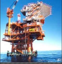
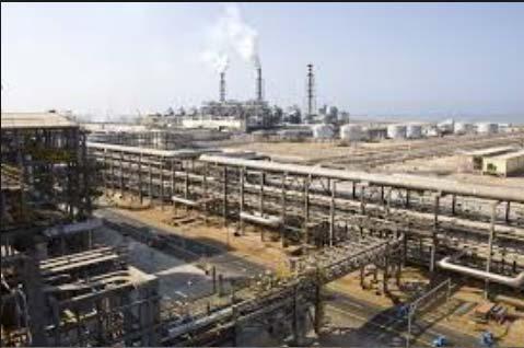
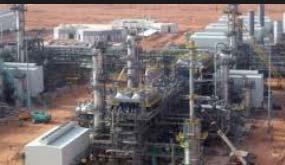
Laser Scanning. 3D Model is not existing and is required for: studies revamping maintenance HSE integration in another 3D model archiving
|
|
|
- Dale Hodge
- 5 years ago
- Views:
Transcription


1 Laser Scanning
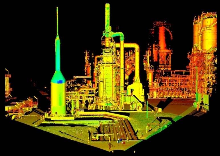
2 Laser Scanning Laser scanning is used whenever: 3D Model is not existing and is required for: studies revamping maintenance HSE integration in another 3D model archiving 2


3 Object acquisition (NO CONTACT SYSTEM) This instrument allow to work without having to interrupt the production cycle of plant, in full safety, thanks to no contact system technology, which allow to acquire objects over 100 mt. The instrumentation 3D Laser Scanner allows you to have a complete and precise data acquisition facilitates the design and phases of action


, higher will be the")
4 Points cloud acquired by Laser Scanner 3D Modeling of points cloud to realize the 3D model Higher is the requested resolution (more details), higher will be the cloud density

.")
5 POINTS CLOUD With the 3D software is possible to model civil structures, plants on the land or off shore 3D PLANT MODEL The various elements (such as flanges, pipes, beams, etc) can be geometrically modeled as per tables agreed with the Client (ASME, ANSI, DIN, AISC, etc). The generated model can be utilized on other 3D softwares.

 Possibility to model the points cloud only")
6 Possibility to find interferences between the real status and the design (this is due to the possibility to import the points cloud in the used design software) Possibility to model the points cloud only where necessary
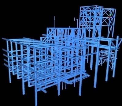
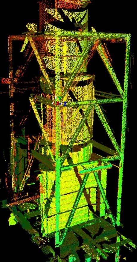
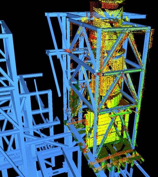
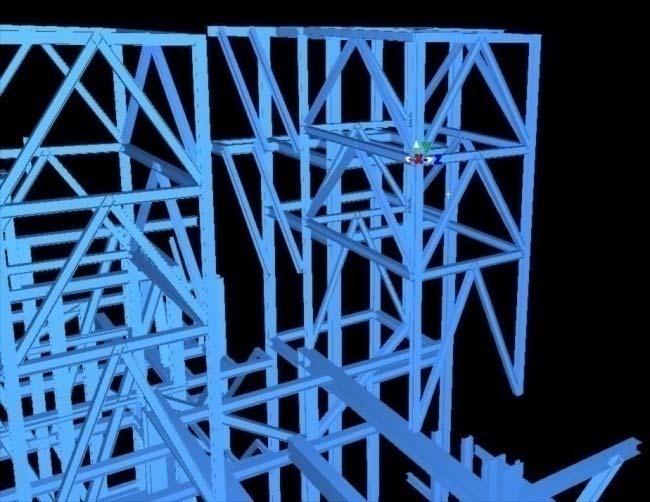
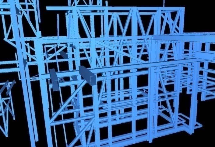
7 Conversion from points cloud to 3D model for structures


8 Possibility to post elaborate the acquired data with Cyclone software or other applications such as Autocad, Revit, Maya, Microstation, PDS, PDMS and SmartPlant 3D, all with Cluodworx plug in


9 APPLICATIONS 1. Data As Found generated by points cloud; 2. 3D model perfectly sized and positioned; 3. Design support; 4. Simulations and analysis of installation alternatives (to be used to minimize problems during the construction phase); 5. Inspection during the construction; 6. Verification of the changes in the course of time; 7. Construction of 3D virtual model; 8. Safety.
10 ADVANTAGES 1. With the 3D model obtained by laser scanning is possible to measure instantly on the PC; 2. Thanks to instrumentation 3D laser scanner the survey is objective and not more subjective; 3. Project studies are simpler, starting directly from a 3D model real and full; 4. The acquisition phase is safety done thanks to no contact system utilized by 3D laser scanner, which allow to detect objects at distances over 100 m. at high temperatures, and in dangerous or not accessible places; 5. The generated 3D model can be used in many fields of applications e.g.: maintenance, engineering, process verifications, construction, training, etc...; 6. The generated data may be used with many CAD software such as Autocad, Revit, Maya, Microstation, PDS, PDMS, SmartPlant 3D, PlantSpace, AutoPlant, ProE etc...; 7. Cost reduction in survey procedure and in 3D model creation; 8. The 3D Laser Scanner technology allow to acquire data without any interruption during plant operations; 9. The high quantity of data acquired, remove the risk to having to return on site for making other measurements; 10. The 3D Laser Scanner technology reduces the periods as regards the work on existing plants such as enlargements, revamps, retrofits, etc...; 11. Reduction of parts mounting time, because you can define in the office the right paths within the plant to follow, eliminating the risks of find obstacles that prevent the assembly or the passage of parts required; 12. Thanks to network connection you can control in real time the acquired data; 13. The 3D Laser Scanner technology, eliminates the error of recognition of the geometries, shapes and positioning of the objects.


11 SURVEY PROCEDURE POSITIONING OF REFERENCE TARGETS CONSTRUCTION OF A CLOSED TOPOGRAPHICALLY CALCULATED POLYGONAL DATA ACQUISITION BY INSTRUMENTATION 3D LASER SCANNER GEOREFERENCING OF POLYGONAL ON THE PLANT COORDINATE SYSTEM GEOREFERENCING OF LASER SCANS ON THE TOPOGRAPHIC SURVEY REGISTRATION OF SCANS TO OBTAIN A SINGLE POINTS CLOUD DATABASE


12 SURVEY PROCEDURE 1: Identification of the areas to be scanned; 2: Materialization of closed polygonals to use as a reference for topographic calculation;

13 SURVEY PROCEDURE 3: Creating a network of polygonals connected to the main already georeferenced to acquire targets topographically; 4: Executing of various laser scans in order to cover all areas to survey;


14 SURVEY PROCEDURE 5: Topographic calculation with specific softwares; 6: Registration and georeferencing of the laser scans into a single points cloud database


15 7: Creation of a single points cloud database; SURVEY PROCEDURE
POINT CLOUD based REVERSE ENGINEERING. Young-Ho Chai, Ph.D
 POINT CLOUD based REVERSE ENGINEERING Young-Ho Chai, Ph.D 3D Spatial Survey Workflow Hardware Requirements Phase Based Laser Scanner: -Leica ScanStation P20 x 1EA -Usage: Short-range, ~80m Time of Flight
 www.lfm-software.com LFM Software Overview Realise the true value of your laser scan data. Outside the EPC environment, Owner Operators are now also recognising the benefits of 3D laser scanning. Laser
3D Industrial plants. Documentation
 3D Industrial plants Documentation Published by: FARO Europe GmbH & Co. KG, Lingwiesenstrasse 11/2, D-70825 Korntal-Münchingen, Tel: +49 7150 9797-0, Fax: +49 7150 9797-44, info@faroeurope.com, www.faro.com
OPEN. INTELLIGENT. Laser Scanning Software Solutions
 OPEN. INTELLIGENT. Laser Scanning Software Solutions www.lfm-software.com The Future of Laser Scanning Safe and efficient operation of complex engineering assets, and the efficient management of their
Extracting Plant Deliverables from AutoCAD Point Clouds
 Extracting Plant Deliverables from AutoCAD Point Clouds The webinar will begin shortly. You will hear silence until the webinar begins. Please note that this webinar is being recorded and all registrants
Terrestrial 3D laser scanning Practical aspects
 Terrestrial 3D laser scanning Practical aspects ISPRS WG VI/5&SC Summer School 2007 by Gregor Bilban 3D laser scanning Benefits Lower data collection costs Reduction or elimination of re-visits More accurate
Most as-built information is still manually collected. Today s Design Market
 Agenda 1. Overview of 3D laser scanning 2. HDS 3D Laser scanning applications Leica ScanStation2 True Color Scan 3. Demonstration of HDS & Trueview 4. Questions and Answers The advanced 3D Laser Scanning
UAVs & IMAGES ACCESSORIES ABOUT GEXCEL
 LIDAR SOFTWARE UAVs & IMAGES MONITORING MOBILE MAPPING ACCESSORIES OTHER ABOUT GEXCEL BUSINESS TEAM LOCATIONS Gexcel offices are located in Italy in two Innovation Centers SALES NETWORK Gexcel s worldwide
Marc De Bruyne 3D Design Improvement Leader, DOW Chemical
 Marc De Bruyne 3D Design Improvement Leader, DOW Chemical John Foster Director, Profox Companies DOW Chemical Terneuzen in the Netherlands Globally, second largest DOW site after Freeport US. Producing
Leica Cyclone 5.4 Technical Specifications
 Leica Cyclone 5.4 Technical Specifications HDS Scanner control and operation Scan Scan Scan Register Model Survey Viewer Acquire and display image Acquire image at specified resolution (high, medium, low)
Laser Scanning & Creation of 3D Models For BIM and Process Facilities
 Specialised Surveying Solutions Presented to: ICES UAE Region Abu Dhabi November 2009 Land and Engineering Surveying Services 3D Laser Scanning & Modeling Laser Scanning Technology Zoller+Fröhlich Phase
3D SPATIAL DATA ACQUISITION AND MODELING OF ANGHEL SALIGNY MONUMENT USING TERRESTRIAL LASER SCANNING
 JOURNAL OF APPLIED ENGINEERING SCIENCES VOL. 2(15), issue 2_2012 ISSN 2247-3769 ISSN-L 2247-3769 (Print) / e-issn:2284-7197 3D SPATIAL DATA ACQUISITION AND MODELING OF ANGHEL SALIGNY MONUMENT USING TERRESTRIAL
With FARO PointSense for Revit. Jörg Braunes Platform Owner Software Chris Palmer Sales Engineer 1
 From Point Clouds to BIM Models With FARO PointSense for Revit Jörg Braunes Platform Owner Software Chris Palmer Sales Engineer 1 Agenda Scan to BIM with Revit PointClouds in Revit Advanced Workflow with
ARECATECH SDN BHD CAPTURE THE REALITY IN TOUCH WITH TOMORROW
 CAPTURE THE REALITY IN TOUCH WITH TOMORROW ARECATECH SDN BHD 3D Laser Scanning Integrity and Management Services Detail Engineering Design Support & COMOS Intelligent P & ID Services SmartPlant - PDMS
Displayed with permission The American Surveyor April/May Copyright 2009 Cheves Media
 NASA s Environmental Simulation Chamber A at the Johnson Space Center in Houston will require upgrades to accommodate testing of components for the new space telescopes. Laser scanning with the FARO LS
General Software. Program (Software House) Function. Office Productivity. Office (Microsoft) PDF File Generation and Management
 Function. Office Productivity. Office (Microsoft) PDF File Generation and Management") Company Software General Software Office (Microsoft) Office Productivity Acrobat Professional (Adobe) Primavera P6 Professional R8.2 (Oracle) Microstation Ver.J, V8,XS and all versions (Bentley) Autocad
Company Software General Software Office (Microsoft) Office Productivity Acrobat Professional (Adobe) Primavera P6 Professional R8.2 (Oracle) Microstation Ver.J, V8,XS and all versions (Bentley) Autocad
Geospatial Engineering Problems & Solutions Associated With NDP Roads, Tunnelling & Civil Engineering Projects Use of HDS Leica Laser Scanners
 Geospatial Engineering Problems & Solutions Associated With NDP Roads, Tunnelling & Civil Engineering Projects Use of HDS Leica Laser Scanners Laser Scanning Laser Scanning is a method of collecting large
Leica High-Definition Surveying Systems. Leica HDS3000. The Industry Standard for High-Definition Surveying
 Leica High-Definition Surveying Systems Leica HDS3000 The Industry Standard for High-Definition Surveying HDS High-Definition Surveying TM : Laser Scanning Redefined High-Definition Surveying, or HDS,
The Leica HDS Family. The Right Tool for the Job HDS3000 HDS2500 HDS4500. Cyclone & CloudWorx. Press the QuickScan button to define the field-of-view.
 HDS2500 High accuracy scanner, ideal for fixed or raised installations when leveled tripod mounting is not practical, or areas with less stringent field-of-view requirements. The Leica HDS Family Time-of-flight
APPLICATION OF 3D TERRESTRIAL LASER SCANNING IN THE PROCESS OF UPDATE OR CORRECTION OF ERRORS IN THE CADASTRAL MAP
 Presented at the FIG Working Week 2017, May 29 - June 2, 2017 in Helsinki, Finland Dr.-Eng. Gintcho Kostov GEO ZEMIA Ltd. 1 1. Introduction 3D Terrestrial laser scanning delivers highly accurate spatial
Three-Dimensional Laser Scanner. Field Evaluation Specifications
 Stanford University June 27, 2004 Stanford Linear Accelerator Center P.O. Box 20450 Stanford, California 94309, USA Three-Dimensional Laser Scanner Field Evaluation Specifications Metrology Department
Leveraging Point Clouds to Produce Accurate As-Built Models. Sonia Delgadillo
 Leveraging Point Clouds to Produce Accurate As-Built Models Sonia Delgadillo Time What is CADWorx fieldpipe? Easy customization Comprehensive specs Short learning curve AutoCAD -based CADWorx Plant Design
Leica ScanStation C10 The All-in-One Laser Scanner for Any Application
 The All-in-One Laser Scanner for Any Application Versatility, Productivity, Value Many organizations interested in laser scanning to diversify and/or improve current business have been waiting for a scanner
BIM PROCESS COMPARING NEW BUILD WITH EXISTING ASSETS A VERY QUICK SUMMARY OF THE PROCESS
 : STEPPING INTO THE FUTURE WITH THE PAST HYBRID MODELLING IN THE BIM PROCESS CARL BROOKES 8 DECEMBER 2017 INTRODUCTION Very quick summary of BIM process Comparing New build with existing assets 3D model
3D LASER SCANNING SERVICES
 3D LASER SCANNING SERVICES O I L G A S O F F S H O R E 4 6 8 3D POINT CLOUD 3D MODEL 360 PANORAMIC VIEW ONLINE OR OFFLINE WEB PLATFORM What is 3D laser scanning? The 3D laser scanning technology is the
technical notes trimble realworks software
 technical notes trimble realworks software A POWERFUL 3D LASER SCANNING OFFICE SOFTWARE SUITE Designed for today s multifaceted scanning professional, Trimble RealWorks is a powerful office software that
MODELING CITY HALL S FAÇADE USING LASER SCANNING TECHNOLOGY
 Преглед НЦД 15 (2009), 59 63 Vladimir Pajić, Dušan Jovanović Miro Govedarica (Faculty of Technical Sciences, Novi Sad, Serbia) MODELING CITY HALL S FAÇADE USING LASER SCANNING TECHNOLOGY Abstract. This
Trimble Realworks Software
 TECHNICAL NOTES Trimble Realworks Software A Powerful 3D Laser Scanning Office Software Suite DESIGNED FOR TODAY S MULTIFACETED SCANNING PROFESSIONAL, TRIMBLE REALWORKS IS A POWERFUL OFFICE SOFTWARE THAT
HP-L-8.9 LASER SCANNER
 PRODUCT BROCHURE HP-L-8.9 LASER SCANNER Cost-effective laser scanning for the ROMER Absolute Arm 2 HP-L-8.9 LASER SCANNER HIGHLIGHTS MAKING LASER SCANNING ACCESSIBLE TO ALL The HP-L-8.9 is an affordable
ROHR2. Program System ROHR2 Interfaces - Overview and Details. SIGMA Ingenieurgesellschaft mbh
 ROHR2 Program System ROHR2 Interfaces - Overview and Details ROHR2 Interfaces Feature List Content ROHR2 Introduction... 1 1 ROHR2 interfaces... 1 1.1 ROHR2 Interfaces overview... 2 1.2 Licenses and system
Realworks Software. A Powerful 3D Laser Scanning Office Software Suite
 TECHNICAL NOTES Realworks Software A Powerful 3D Laser Scanning Office Software Suite Trimble RealWorks is a powerful office software that imports rich data from your 3D laser scanning instrument and transforms
RealWorks Software. A Powerful 3D Laser Scanning Office Software Suite
 TECHNICAL NOTES RealWorks Software A Powerful 3D Laser Scanning Office Software Suite Trimble RealWorks is a powerful office software that imports rich data from your 3D laser scanning instrument and transforms
HIGH-DEFINITION SURVEY AND BIM PRESENTATION FOR BIM-MEP AUS
 www.aamgroup.com/bim HIGH-DEFINITION SURVEY AND BIM PRESENTATION FOR BIM-MEP AUS Matt Rumbelow, B.Arch AAM BIM Coordinator ABOUT AAM Reality Captured. Certainty Delivered Reality Captured. Certainty Delivered
TLS Parameters, Workflows and Field Methods
 TLS Parameters, Workflows and Field Methods Marianne Okal, UNAVCO June 20 th, 2014 How a Lidar instrument works (Recap) Transmits laser signals and measures the reflected light to create 3D point clouds.
Terrestrial Laser Scanning assignment
 Terrestrial Laser Scanning assignment Objective: Underground 3D survey using terrestrial laser scanning Location: Otaniemi campus, Innopoli 3 Business Area Equipment: Faro Focus 3D Methodology: Multiple
ASSETS DATA INVENTORY BASED ON BUILDING INFORMATION MODELLING
 ASSETS DATA INVENTORY BASED ON BUILDING INFORMATION MODELLING Asep Yusup Saptari (Surveying and Cadastre Research Group) Geodesy And Geomatic Earth Science And Engineering Faculty Institut Teknologi Bandung
AUTOMATIC ORIENTATION AND MERGING OF LASER SCANNER ACQUISITIONS THROUGH VOLUMETRIC TARGETS: PROCEDURE DESCRIPTION AND TEST RESULTS
 AUTOMATIC ORIENTATION AND MERGING OF LASER SCANNER ACQUISITIONS THROUGH VOLUMETRIC TARGETS: PROCEDURE DESCRIPTION AND TEST RESULTS G.Artese a, V.Achilli b, G.Salemi b, A.Trecroci a a Dept. of Land Planning,
EQUIPMENT REMOVAL AND INSTALLATION PROCESS USING LASER SCANNING TECHNOLOGY
 EQUIPMENT REMOVAL AND INSTALLATION PROCESS USING LASER SCANNING TECHNOLOGY LASER SCANNING TECHNOLOGY PROVIDES A VERY EFFECTIVE TOOL TO SUPPORT COMPLEX RIGGING PLANNING AND EXECUTION EQUIPMENT REMOVAL &
Bentley OpenPlant PowerPID
 Bentley OpenPlant PowerPID Agenda Presenter Rob Harper Director of Product Management OpenPlant PowerPID Overview What is OpenPlant PowerPID OpenPlant PowerPID Features Specification Mapping and 2D to
TERRESTRIAL LASER SCANNING AND APPLICATION IN GEODETIC ENGINEERING
 TERRESTRIAL LASER SCANNING AND APPLICATION IN GEODETIC ENGINEERING Marko Pejić U n i ve rs i t y o f B e l g ra d e, Fa c u l t y o f C i v i l E n g i n e e r i n g Mostar, 10.19.2017. TLS method and
3D Terrestrial Laser Scanner Innovative Applications for 3D Documentation
 3D Terrestrial Laser Scanner Innovative Applications for 3D Documentation Rodney Chaffee Head of Sales, FARO Asia Pacific 3D Laser Scaning Market 2017 2.3 Billion $ 2012 1.3 Billion $ CAGR : > 12% Source:
NEW APPROACH FOR SAFE, FAST AND ACCURATE SURVEY OF DEEP MINE SHAFTS
 NEW APPROACH FOR SAFE, FAST AND ACCURATE SURVEY OF DEEP MINE SHAFTS by Norbert Benecke & Peter Cain DMT GmbH &Co. KG, Germany / DMT Geosciences, Canada Kinemattic Shaft Survey 2013 Page 1 Who is DMT? is
Real World to Virtual World. With Geomagic Design X
 Real World to Virtual World With Geomagic Design X About OR3D OR3D based in UK with offices in Wrexham (Wales) and Bristol (England) Cover the UK and Internationally UK s largest supplier of Geomagic software
BACES3D is a trade mark of company: Friulrobot S.r.l.
 BACES3D is a trade mark of company: Friulrobot S.r.l. Via Malignani, 20/B - 33035 MARTIGNACCO (UDINE) ITALY tel +39 0432 678543 fax +39 0432 637531 www.baces3d.com MEASURING ARM Baces3D: Introduction Baces3D
3D Grid Size Optimization of Automatic Space Analysis for Plant Facility Using Point Cloud Data
 33 rd International Symposium on Automation and Robotics in Construction (ISARC 2016) 3D Grid Size Optimization of Automatic Space Analysis for Plant Facility Using Point Cloud Data Gyu seong Choi a, S.W.
Virtually Real: Terrestrial Laser Scanning
 Check. They re Chartered. Geomatics Client Guides Virtually Real: Terrestrial Laser Scanning Understanding an evolving survey technology Summary This guide gives you an overview of the technique, some
Integrating the Generations, FIG Working Week 2008,Stockholm, Sweden June 2008
 H. Murat Yilmaz, Aksaray University,Turkey Omer Mutluoglu, Selçuk University, Turkey Murat Yakar, Selçuk University,Turkey Cutting and filling volume calculation are important issues in many engineering
Tebodin Peters Engineering GmbH
 Plant Design using Laserscan www.peters.bilfinger.com WE DESIGN THE FUTURE www.bilfinger.com Planning in existing Plants In revamp and expansion projects for existing plants, an accurate measurement is
SUMMARY. Page INTERIOR SURVEY - SAN FRANCESCO CHURCH (TERNI) EXTERIOR SURVEY - UFFIZI & PIAZZA DUOMO TUNNEL SURVEY TERNI
 EXTERIOR SURVEY - UFFIZI & PIAZZA DUOMO TUNNEL SURVEY TERNI") CASE STUDIES SUMMARY Page INTERIOR SURVEY - SAN FRANCESCO CHURCH (TERNI) EXTERIOR SURVEY - UFFIZI & PIAZZA DUOMO TUNNEL SURVEY TERNI FOREST SURVEY - MARMORE WATERFALLS ROAD SURVEY FERRARA 3 4 5 6 7 2 INTERIOR
CASE STUDIES SUMMARY Page INTERIOR SURVEY - SAN FRANCESCO CHURCH (TERNI) EXTERIOR SURVEY - UFFIZI & PIAZZA DUOMO TUNNEL SURVEY TERNI FOREST SURVEY - MARMORE WATERFALLS ROAD SURVEY FERRARA 3 4 5 6 7 2 INTERIOR
MODERN TECHNOLOGY FOR LAND LEVELLING, BASED ON A 3D SCANNER
 MODERN TECHNOLOGY FOR LAND LEVELLING, BASED ON A 3D SCANNER Abstract: Soil levelling becomes of high importance, in modern and intensive agriculture conditions. Its effects are found in providing optimal
Overview of the Trimble TX5 Laser Scanner
 Overview of the Trimble TX5 Laser Scanner Trimble TX5 Revolutionary and versatile scanning solution Compact / Lightweight Efficient Economical Ease of Use Small and Compact Smallest and most compact 3D
ENY-C2005 Geoinformation in Environmental Modeling Lecture 4b: Laser scanning
 1 ENY-C2005 Geoinformation in Environmental Modeling Lecture 4b: Laser scanning Petri Rönnholm Aalto University 2 Learning objectives To recognize applications of laser scanning To understand principles
2011 Bentley Systems, Incorporated. Bentley Descartes V8i Advancing Information Modeling For Intelligent Infrastructure
 Bentley Descartes V8i Advancing Information Modeling For Intelligent Infrastructure Agenda Why would you need Bentley Descartes? What is Bentley Descartes? Advanced Point Cloud Workflows Advanced Terrain
Engineering Systems Manager
 02/04/2006 1 Engineering Systems Manager Colin K Fairweather 02/04/2006 2 Point Cloud Data With PDMS On Brownfield Projects What are the benefits and why use the technology? 02/04/2006 3 The History of
An Introduction to Lidar & Forestry May 2013
 An Introduction to Lidar & Forestry May 2013 Introduction to Lidar & Forestry Lidar technology Derivatives from point clouds Applied to forestry Publish & Share Futures Lidar Light Detection And Ranging
USE THE 3D LASER SCANNING FOR DOCUMENTATION THE RIGA CATHEDRAL IN LATVIA
 USE THE 3D LASER SCANNING FOR DOCUMENTATION THE RIGA CATHEDRAL IN LATVIA Maris Kalinka, Elina Rutkovska, Department of Geomatic, Riga Technical University, Azenes 16-109, Riga, Latvia, geomatika@geomatika.lv
Gregory Walsh, Ph.D. San Ramon, CA January 25, 2011
 Leica ScanStation:: Calibration and QA Gregory Walsh, Ph.D. San Ramon, CA January 25, 2011 1. Summary Leica Geosystems, in creating the Leica Scanstation family of products, has designed and conducted
2011 Bentley Systems, Incorporated. Bentley Descartes V8i (SELECTseries 3) Advancing Information Modeling For Intelligent Infrastructure
 Advancing Information Modeling For Intelligent Infrastructure") Bentley Descartes V8i (SELECTseries 3) Advancing Information Modeling For Intelligent Infrastructure What is Bentley Descartes? Image Processing Raster Geo-Referencing Advanced raster transformation (warping,
Bentley Descartes V8i (SELECTseries 3) Advancing Information Modeling For Intelligent Infrastructure What is Bentley Descartes? Image Processing Raster Geo-Referencing Advanced raster transformation (warping,
IMPROVEMENT OF AIRCRAFT MECHANICAL DAMAGE INSPECTION WITH ADVANCED 3D IMAGING TECHNOLOGIES
 IMPROVEMENT OF AIRCRAFT MECHANICAL DAMAGE INSPECTION WITH ADVANCED 3D IMAGING TECHNOLOGIES MARK MAIZONNASSE 60TH A4A NDT FORUM SEPTEMBER 2017, FORT LAUDERDALE, FL, USA BRIDGING PHYSICAL AND DIGITAL WORLDS
Reverse Engineering Tool to improve quality and efficiency of design, manufacture and analysis.
 Reverse Engineering Tool to improve quality and efficiency of design, manufacture and analysis. INTRODUCTION The Internet and technology in general has forever changed the world. This dawning of the technical
ON THE ROAD JULY/AUGUST MAP PROJECTIONS The importance of horizontal and vertical datums in GIS mapping
 VOLUME 4 ISSUE 5 JULY/AUGUST 2014 ON THE ROAD 30 40 62 MAP PROJECTIONS The importance of horizontal and vertical datums in GIS mapping FOLLOW THE LEDDAR A special purpose sensor that does several 3D measurement
Suite en It Up with Autodesk ReCap
 Chad Studer ADSK Solutions RC3165 Static and mobile laser scanning technologies capture millions of points and provide photorealistic interactive virtual sites known as point clouds. With Autodesk ReCap
INVESTIGATION ON LASER SCANNERS *
 IWAA2004, CERN, Geneva, 4-7 October 2004 INVESTIGATION ON LASER SCANNERS * Brian Fuss, Catherine Le Cocq, Robert Ruland Stanford Linear Accelerator Center, Stanford, CA, USA Rudolf Staiger Essen University,
Terrestrial LiDAR. Patrick Crawford. Harnessing the Power of Big Data for Asset and Facility Management WHITE PAPER SHAFER, KLINE & WARREN
 WHITE PAPER Terrestrial LiDAR Harnessing the Power of Big Data for Asset and Facility Management Patrick Crawford Team Leader, Geospatial Systems SHAFER, KLINE & WARREN Executive Summary Terrestrial LiDAR
3D scanning verifies the precision of objects printed on 3D printers
 3D scanning verifies the precision of objects printed on 3D printers Quality control: inspection of 3D printed supercar part 3D scanner: MICRON3D green 10 MPix 3D printer: Factory 2.0 Production System
INTEGRATING PHOTOGRAMMETRIC TECHNOLOGIES AND GEODETIC METHODS FOR 3D MODELING
 INTEGRATING PHOTOGRAMMETRIC TECHNOLOGIES AND GEODETIC METHODS FOR 3D MODELING Georgeta Pop Faculty of Geodesy, Geodesy and Photogrammetry Department, Technical University of Civil Engineering Bucharest,
QUALITY CONTROL METHOD FOR FILTERING IN AERIAL LIDAR SURVEY
 QUALITY CONTROL METHOD FOR FILTERING IN AERIAL LIDAR SURVEY Y. Yokoo a, *, T. Ooishi a, a Kokusai Kogyo CO., LTD.,Base Information Group, 2-24-1 Harumicho Fuchu-shi, Tokyo, 183-0057, JAPAN - (yasuhiro_yokoo,
Mobile Mapping with the Road-Scanner in France Hi-grade 1:200 scale mapping
 FARO USER CONFERENCE APRIL 27-28 2014 Mobile Mapping with the Road-Scanner in France Hi-grade 1:200 scale mapping 03/04/2014 ing. Augusto Burchi burchi@sitecoinf.it Siteco's profile Founded in 2000 as
Unveiling ProjectWise Navigator V8i The Information Rich Review Alternative
 Unveiling ProjectWise Navigator V8i The Information Rich Review Alternative Tony DeRosa Interoperability Priorities Reusable and Complete Information Exchange rich heterogeneous information Rely upon secure
Leica Cyclone 8.1 Leica CloudWorx Technical Specifications
 Leica 8.1 Leica CloudWorx Technical Specifications Leica 8.1 Technical Specifications HDS SCANNER CONTROL AND OPERATION & REGISTRATION Acquire and display image ^ ^ ^ Acquire image at specified resolution
Increase Field Survey Efficiency by Merging Technologies in NOVA MultiStation. Vincent Lui Leica Geosystems Ltd
 Increase Field Survey Efficiency by Merging Technologies in NOVA MultiStation Vincent Lui Leica Geosystems Ltd Advantages of Laser Scanning Advantages of TPS Measurements Advantages of Imaging Advantages
Figure 1: Mobile mapping project location in New York City.
 Using Mobile LiDAR to Deliver Survey Accurate Data This presentation will take the attendees though the process of controlling and delivering survey grade LiDAR data for use in CADD, Modeling, and GIS
MLD 500, MLD 300 Multiple Light Beam Safety Devices and transceiver with integrated muting
 2 rue René Laennec 51500 Taissy France Fax: 03 26 85 19 08, Tel : 03 26 82 49 29 E-mail:hvssystem@hvssystem.com Site web : www.hvssystem.com MLD 500, MLD 300 Multiple Light Beam Safety Devices and transceiver
INDUSTRIAL PHOTOGRAMMETRY FOR APPLICATIONS IN AUTOMOTIVE AND AEROSPACE INDUSTRY
 INDUSTRIAL PHOTOGRAMMETRY FOR APPLICATIONS IN AUTOMOTIVE AND AEROSPACE INDUSTRY 56th Photogrammetric Week 1 INDUSTRIAL PHOTOGRAMMETRY FOR APPLICATIONS IN AUTOMOTIVE AND AEROSPACE INDUSTRY Werner Bösemann
Point Cloud Processing and Large Scalable Terrain Model Extraction Inga Morozoff
 Point Cloud Processing and Large Scalable Terrain Model Extraction Inga Morozoff 1 Point cloud data is a new data type that s being driven by the need for accurate 3D as-built information. Point cloud
Explore Laser Scanning in As-Built Survey. Vijay Chowdhary SE: BIM/CIM
 Explore Laser Scanning in As-Built Survey Vijay Chowdhary SE: BIM/CIM About FARO The world leader in portable 3-D measurement and imaging technology EMEA Headquarters Korntal-Münchingen, Germany APAC Headquarters
US foundry Bradken implements optical measuring technology
 Application Note US foundry Bradken implements optical measuring technology Location / country: Tacoma / Washington, USA GOM systems: ATOS Triple Scan, TRITOP GOM software: ATOS Professional Sector: Power
TLS Parameters, Workflows and Field Methods
 TLS Parameters, Workflows and Field Methods Marianne Okal, UNAVCO GSA, September 23 rd, 2016 How a Lidar instrument works (Recap) Transmits laser signals and measures the reflected light to create 3D point
ROAD-SCANNER COMPACT APPLICATION FIELDS MAIN FEATURES
 ROAD-SCANNER COMPACT Mobile Mapping System by GEXCEL & SITECO collaboration A smaller mobile system for asset management and cartography suited for ZOLLER & FRÖHLICH PROFILER 9012 laser scanner. 2 + 3
3D Manufacturing Facility and Production Line Capture
 SPAR 2004 Symposium May 19, 2004 3D Manufacturing Facility and Production Line Capture Presented by: Bill Campbell GM Vehicle Operations Competitive Operations Engineering Mike Ryan GHAFARI Companies SPAR
A 3D Scanner Based Technology for Land Levelling
 A 3D Scanner Based Technology for Land Levelling Kunal Chakraborti, Rupam Ghosh Student, Dept of Civil Engineering, Modern Institute of Engineering & Technology, Bandel, Hooghly, West Bengal, India ABSTRACT:
RIEGL LMS-Q780. The Versatile, High Altitude Airborne LIDAR Sensor
 RIEGL LMS-Q780 3050m 400kHz The full waveform airborne laser scanner offers great versatility, accuracy, and data quality. The scanner enables you to successfully deliver your projects with industry leading
SOFTWARE SOLUTIONS. Cadmatic enews 2014Q3
 Cadmatic enews 2014Q3 Contents Release highlights Increased flexibility via improved interoperability Upcoming events 2 Contact Us Release highlights Version 2014Q3 of Cadmatic continues the new generation
Experiments on Generation of 3D Virtual Geographic Environment Based on Laser Scanning Technique
 Experiments on Generation of 3D Virtual Geographic Environment Based on Laser Scanning Technique Jie Du 1, Fumio Yamazaki 2 Xiaoyong Chen 3 Apisit Eiumnoh 4, Michiro Kusanagi 3, R.P. Shrestha 4 1 School
Reverse Engineering: Mechanical. Dr. Tarek A. Tutunji
 Reverse Engineering: Mechanical Dr. Tarek A. Tutunji Mechanical RE References: 1. RE (reverse engineering) as necessary phase by rapid product development by Sokovic and Kopac 2. A Practical Appreciation
T-SCAN 3 3D DIGITIZING
 T-SCAN 3 3D DIGITIZING 2 T-SCAN 3: THE HANDHELD LASER SCANNER Launching the innovative concept of an intuitive-to-use high-precision laser scanner a few years ago, Steinbichler Optotechnik, as the first
POINT CLOUD REGISTRATION: CURRENT STATE OF THE SCIENCE. Matthew P. Tait
 POINT CLOUD REGISTRATION: CURRENT STATE OF THE SCIENCE Matthew P. Tait Content 1. Quality control: Analyzing the true errors in Terrestrial Laser Scanning (TLS) 2. The prospects for automatic cloud registration
High Definition Modeling of Calw, Badstrasse and its Google Earth Integration
 Master Thesis Yuanting LI High Definition Modeling of Calw, Badstrasse and its Google Earth Integration Duration of the Thesis: 6 months Completion: July, 2014 Supervisors: Prof.Dr.-Ing.Dieter Fritsch
3D MODELING OF CLOSE-RANGE OBJECTS: PHOTOGRAMMETRY OR LASER SCANNING?
 3D MODELING OF CLOSE-RANGE OBJECTS: PHOTOGRAMMETRY OR LASER SCANNING? F. Remondino 1 A. Guarnieri 2 A. Vettore 2 1 Institute of Geodesy and Photogrammetry ETH Hönggerberg - Zurich, Switzerland e-mail:
TAKING LIDAR SUBSEA. Adam Lowry, Nov 2016
 TAKING LIDAR SUBSEA Adam Lowry, Nov 2016 3D AT DEPTH Based in the technology hub of Boulder, Colorado, 3D at Depth is dedicated to the development of underwater laser measurement sensors and software Patented
SPS ZOOM D Laser Scanner SPS ZOOM 300
 3D Laser Scanner 3D Laser Scanner A 3D laser scanner is a device that collects precise spatial data of objects or environments. The collected point cloud data can then be used to construct digital three
TERRESTRIAL LASER SYSTEM TESTING USING REFERENCE BODIES
 TERRESTRIAL LASER SYSTEM TESTING USING REFERENCE BODIES Miriam Zámečníková and Alojz Kopáčik Department of Surveying, Faculty of Civil Engineering Slovak University of Technology Email: miriam.zamecnikova@stuba.sk
Intensity Augmented ICP for Registration of Laser Scanner Point Clouds
 Intensity Augmented ICP for Registration of Laser Scanner Point Clouds Bharat Lohani* and Sandeep Sashidharan *Department of Civil Engineering, IIT Kanpur Email: blohani@iitk.ac.in. Abstract While using
String monitoring with CMS - Circuit monitoring system Increased productivity and improved maintenance of PV systems
 S O L A R S T R I N G M O N I TO R I N G String monitoring with CMS - Circuit monitoring system Increased productivity and improved maintenance of PV systems Solar plant operators are constantly facing
FARO As-Built for AutoCAD Software Versatile Reality to CAD Solutions
 FARO As-Built for AutoCAD Software Versatile Reality to CAD Solutions FARO As-Built for Autodesk Revit Creating Efficiencies in Scan Data Extraction for BIM FARO As-Built for AutoCAD Software TM Versatile
Phased Array Assisted Manual Nozzle Inspection Solution with Data Archiving Capability
 19 th World Conference on Non-Destructive Testing 2016 Phased Array Assisted Manual Nozzle Inspection Solution with Data Archiving Capability Jason HABERMEHL 1, Nicolas BADEAU 1, Martin ST-LAURENT 1, Guy
LASER SCANNING SUPPORTS ARCHITECTURAL MAPPINGS AND HISTORICAL URBAN VIEW ANALYSIS
 LASER SCANNING SUPPORTS ARCHITECTURAL MAPPINGS AND HISTORICAL URBAN VIEW ANALYSIS Daniela ORENI*, Francesco FASSI**, Raffaella BRUMANA**, Federico PRANDI**, Hande TUNCER** * DIAP - Politecnico di Milano
USING A LASER SCANNER FOR THE CONTROL OF ACCELERATOR INFRASTRUCTURE DURING THE MACHINE INTEGRATION
 IWAA2004, CERN, Geneva, 4-7 October 2004 USING A LASER SCANNER FOR THE CONTROL OF ACCELERATOR INFRASTRUCTURE DURING THE MACHINE INTEGRATION Tobias Dobers, Mark Jones, Yvon Muttoni, CERN, 1211 Geneva 23,
Digital Preservation of the Aurelius Church and the Hirsau Museum Complex by Means of HDS and Photogrammetric Texture Mapping
 Master Thesis Ruxandra MOROSAN Ruxandra MOROSAN Digital Preservation of the Aurelius Church and the Hirsau Museum Complex by Means of HDS and Photogrammetric Texture Mapping Duration of the Thesis: 6 months
Coordinate Measuring Machines. Non-contact Line-Laser Probe for. Coordinate Measuring Machines. SurfaceMeasure. Catalog No.
 Non-contact Line-Laser Probe for Coordinate Measuring Machines SurfaceMeasure Coordinate Measuring Machines Catalog No.E16000(5) Highly accurate, high speed, and highly efficient The SurfaceMeasure probe