Prof. Jose L. Flores, MS, PS Dept. of Civil Engineering & Surveying
|
|
|
- Myra Holmes
- 5 years ago
- Views:
Transcription


1 Prof. Jose L. Flores, MS, PS Dept. of Civil Engineering & Surveying
2 Problem One of the challenges for any Geographic Information System (GIS) application is to keep the spatial data up to date and accurate. With growing availability of more accurate satellite imagery from IKONOS, Quickbird, OrbView together with traditional aerial photographs, it is possible to keep tighter maintenance cycle than before. Traditionally this is a labor intensive operation that requires great resources from every department. To overcome this it is imperative to develop automatic or semi-automatic processes to detect required features in high resolution imagery.
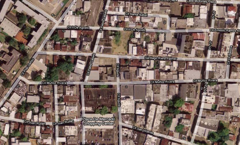


3 Example
4 Common Approach Up to this point, must of the effort in the scientific community have concentrated in locating roads through various an automated approaches since roads are one of the most often changing urban features in a sustainable development society. There are other authors that concentrate their efforts in the location of road intersections. (Haverkamp 2002) follows a low-level pixelbased techniques with higher-level reasoning to extract the intersections.
5 Our Approach In our approach we will use the existing road networks, their geometry, and relative location. However, it is not assumed that this information is complete, accurate; rather it is accurate enough to concentrate the extraction process in confined segments of the image located around intersection points in the road networks. The located intersection points in the image will guide the registration or re-registration process of the road network with reference to the image.
6 Steps Locate intersections on the vector road layers Preprocess image with common filters, like image smooth with edges enhance. Use Canny Edge Detector to find the road edges. Use the Hough Transform (HT) to parameterize the edges into lines. Use only the lines that fit a two lane road pattern, and calculate the center line of the road. Create a point representing an intersection where two center lines meet. Compare these intersection points with the vector layer intersection points to find the appropriate transformation parameters (4) that give the highest yield of matched points. Using the matched points on both points sets, find using least squares, higher order transformation parameters (6 8).
7 Locate Intersections from Road Network Find all vertices on a line (there is duplicity in the points generated) Find all nodes in the intersections using all vertices within 1m of each other as criteria. 6 7,8, (7,8,10 2) L3 L5 L4 5 1 L1 2,3,11,12 4 L L2 15 L7 1 (2,3,11,12 1) Find the intersecting points between specified lines that are at a distance less than 1m of point. Select only the points that are within extent of the intersected line and 1m of the intersecting point. 2 4? ? 1 3
8 Image Preprocessing In order to minimize false road edges in a image caused by shadows, vegetation, texture within an area the image should be preprocessed prior to using the Canny edge detector. Some recommended processing may include: Eliminating preselected areas that may represent vegetation. This is possible using multispectral images. Use of common image processing filters, like image smoothing, edge enhancers and even changing image contrast.


9 Comparison Preprocessing Image Canny edge prior image preprocessing Canny edge post image processing
10 Edge detection from image Edge detection made by Canny edge detection algorithm (Canny, 1986) Canny filter was preferred because it is robust to noise, and more likely to detect true weak edges. This step does not provide parameters to define lines, so another step will needed.
11 The Moving Box for HT First move box along row with 50% overlap Then move to next row still with 50% overlap
12 Facts of the Moving Box for HT Using the moving box methods guaranties searching all possible areas where there could an intersection. The size of the box is 100x100m. Moving the box with a 50% overlap, allows for the box to position itself to accommodate over an intersection without cropping an incoming road from either side of the mention intersection. However, it may provide a higher yield of intersection points within an image, it may also provide duplicate points representing an intersection that are not necessarily overlapping one over the other. This has little consequence given that one of the overlapping points will be ignored when the relative positions with other found intersections is compared with the vector intersection points.
13 Hough Transform (HT) Using the Hough transform to search for edges that represent the border of a road, is more effective if made locally. HT prioritizes the edges from the longest set of pixels that may represent a line to the shortest. So it will provide with most likely set of lines that may represent an road end. However it will not discriminate between different cultural object like road, parking lots or buildings or even natural objects like tree lines.

14 Finding Intersection from HT lines Using the HT lines to find pairs that best represent a two lane road (~7meters). Then calculate the center lines for each pair (dashed lines). Find each intersection between two center lines within the moving box. On the image on the right, the edges of a structure had the same dimension of a road and this provided a false intersection point.
15 Pair Up Sets The procedure to pair up the vector point with the raster points is simple. It will pick the first point select the second and compared distances from sets. If distance match, it determine a set of four parameters for transformation. Then it will check how many points match, then repeat the process, and keep the set of parameters that provide the most match ups. For instance, it will take 1-2 red, compare to 1-5 blue, no match. The go with 1-2 blue, which will match, and get the parameters Yes 5 No No 1 4
16 Pair Up Sets RANSAC Approach With an approach similar the RANSAC (Fischler and Bolles 1981), to fit a model using both set of points, and obtain the most amounts of inliers. Using the relative position between any two points in both sets, a four parameter transformation is done, and counts the matched points in both sets. The points that were not matched are discarded and not used in any further transformation. The parameters that gives the most matched points are 1 used. The paired up points are then used to perform a higher parameter transformation Yes 5 No No 1 4
17 Pairing Raster & Vector Points Green points represent the vector points after matching up with the raster points (blue points) using a four parameter transformation.
18 Registering the Road Layer Once the higher order parameters are obtained these parameters are used to transform the nodes and each vertices of the lines in the road layer. This will finish the process of registering or re-registering the road layer to the georeferenced image.
19 Roads Overlaid Original road layer. Roads after matching with raster points, using a 4 parameter transformation. Roads after applying a higher transformation using the matched points of the previous points.
20 Roads Overlaid Original road layer. Roads after applying a higher transformation using the matched points of the previous points.


21 Closer look at Intersections Original road layer. Roads after matching with raster points, using a 4 parameter transformation. Roads after applying a higher transformation using the matched points of the previous points.


22 Closer look at Intersections Original road layer. Roads after applying a higher transformation using the matched points of the previous points.


23 Closer look at Intersections No raster points in this area (SE) Original road layer. Roads after matching with raster points, using a 4 parameter transformation. Roads after applying a higher transformation using the matched points of the previous points.
 Original road layer.")

24 Closer look at Intersections No raster points in this area (SE) Original road layer. Roads after applying a higher transformation using the matched points of the previous points.


25 Closer look at Intersections Original road layer. Roads after matching with raster points, using a 4 parameter transformation. Roads after applying a higher transformation using the matched points of the previous points.


26 Closer look at Intersections Original road layer. Roads after applying a higher transformation using the matched points of the previous points.
27 Parameters Used Image is a 1 meter resolution panchromatic. The HT algorithm connected pixels into lines with a minimum of 7 pixels, and aloud gaps between pixels of 2 pixels. The maximum number of lines that the HT algorithm detected was 20. Lines to be considered parallel have to within 5 degrees from each other. For a pair of parallel lines be consider road edges they have to be 8(±3) meters apart. This is for a 2 lane rural road. To consider to points a match they should be lest that 20m apart.
28 Conclusions The use of canny edge detection y combination with the Hough Transform to model the edges of a road or street in an intersection has proven to be assertive. More so, they have proven to be independent of orientation of the roads. The use of the moving box to overcome the limit of the HT algorithm proved assertive in locating all possible intersections, even with the few drawbacks. However, the quality of the imagery has great relevance on how the edges would be determined. Preprocessing the imagery to eliminated objects data can be distracting, grass, trees, rivers, and other natural objects, would increase the accuracy of the detection of the road edges. If one or more of the edges are completely invisible, obscured by trees, or other tall objects, it will be impossible to detect the intersection. However, as long as some of the edge is visible, may specify the length of the edge to be accepted, the algorithm will go through and try to find a pair. The RANSAC approach to find matched pairs work extremely well with the data set used, even though there was no correspondence in the number of points used from both sets. Using an high order transformation proved little to adjust the roads and it s intersections with their corresponding location on the image, giving the randomness of distortion on the road, or street location.
29 References Canny, J. (1986). "A Computational Approach To Edge Detection." IEEE Transaction Pattern Analysis and Machine Intelligence 8: Fischler, M. A. and R. C. Bolles (1981). "Random sample consensus: a paradigm for model fitting with applications to image analysis and automated cartography." Communications of the ACM 24(6): Gautama, S. and W. Goeman (2004). Robust Detection of Road Junctions in VHR Images Using an Improved Ridge Detector. Proceedings ISPRS XXth Congress, Istanbul. Habib, A. F., R. I. Al-Ruzouq, et al. (2004). SEMI-AUTOMATIC REGISTRATION AND CHANGE DETECTION USING MULTISOURCE IMAGERY WITH VARYING GEOMETRIC AND RADIOMETRIC PROPERTIES. XXth ISPRS Congress, Istanbul, International Archives of Photogrammetry and Remote Sensing. Haverkamp, D. (2002). "Extracting Straight Road Structure in Urban Environments using IKONOS Satellite Imagery." Societyof Photo-Optical Instrumentation Engineers 41(9): Mena, J. B. (2003). "State of the art on automatic road extraction for GIS update: a novel classification." Pattern Recognition Letters 24(16): Tóth, Z. and A. Barsi (2005). Analyzing Road Junctions by Geometric Transformations. High-Resolution Earth Imaging for Geospatial Information, Hannover, ISPRS.
30 Roads
DIGITAL SURFACE MODELS OF CITY AREAS BY VERY HIGH RESOLUTION SPACE IMAGERY
 DIGITAL SURFACE MODELS OF CITY AREAS BY VERY HIGH RESOLUTION SPACE IMAGERY Jacobsen, K. University of Hannover, Institute of Photogrammetry and Geoinformation, Nienburger Str.1, D30167 Hannover phone +49
Automated Extraction of Buildings from Aerial LiDAR Point Cloud and Digital Imaging Datasets for 3D Cadastre - Preliminary Results
 Automated Extraction of Buildings from Aerial LiDAR Point Cloud and Digital Imaging Datasets for 3D Pankaj Kumar 1*, Alias Abdul Rahman 1 and Gurcan Buyuksalih 2 ¹Department of Geoinformation Universiti
USE OF LINE SEGMENTS IN HIGH RESOLUTION SATELLITE IMAGE REGISTRATION
 USE OF LINE SEGMENTS IN HIGH RESOLUTION SATELLITE IMAGE REGISTRATION J.Heikkinen, A.Laiho-Heikkinen, H.Haggrén Helsinki University of Technology, Department of Surveying Sciences, Group of Photogrammetry
Using Structural Features to Detect Buildings in Panchromatic Satellite Images
 Using Structural Features to Detect Buildings in Panchromatic Satellite Images Beril Sırmaçek German Aerospace Center (DLR) Remote Sensing Technology Institute Weßling, 82234, Germany E-mail: Beril.Sirmacek@dlr.de
IMAGINE Objective. The Future of Feature Extraction, Update & Change Mapping
 IMAGINE ive The Future of Feature Extraction, Update & Change Mapping IMAGINE ive provides object based multi-scale image classification and feature extraction capabilities to reliably build and maintain
IMPROVING 2D CHANGE DETECTION BY USING AVAILABLE 3D DATA
 IMPROVING 2D CHANGE DETECTION BY USING AVAILABLE 3D DATA C.J. van der Sande a, *, M. Zanoni b, B.G.H. Gorte a a Optical and Laser Remote Sensing, Department of Earth Observation and Space systems, Delft
AN EFFICIENT METHOD FOR AUTOMATIC ROAD EXTRACTION BASED ON MULTIPLE FEATURES FROM LiDAR DATA
 AN EFFICIENT METHOD FOR AUTOMATIC ROAD EXTRACTION BASED ON MULTIPLE FEATURES FROM LiDAR DATA Y. Li a, X. Hu b, H. Guan c, P. Liu d a School of Civil Engineering and Architecture, Nanchang University, 330031,
ATOMI Automatic road centreline extraction
 ATOMI input and output data Ortho images DTM/DSM 2D inaccurate structured road vector data ATOMI Automatic road centreline extraction 3D accurate structured road vector data Classification of roads according
UPDATING OBJECT FOR GIS DATABASE INFORMATION USING HIGH RESOLUTION SATELLITE IMAGES: A CASE STUDY ZONGULDAK
 UPDATING OBJECT FOR GIS DATABASE INFORMATION USING HIGH RESOLUTION SATELLITE IMAGES: A CASE STUDY ZONGULDAK M. Alkan 1, *, D. Arca 1, Ç. Bayik 1, A.M. Marangoz 1 1 Zonguldak Karaelmas University, Engineering
OBJECT IDENTIFICATION AND FEATURE EXTRACTION TECHNIQUES OF A SATELLITE DATA: A REVIEW
 OBJECT IDENTIFICATION AND FEATURE EXTRACTION TECHNIQUES OF A SATELLITE DATA: A REVIEW Navjeet 1, Simarjeet Kaur 2 1 Department of Computer Engineering Sri Guru Granth Sahib World University Fatehgarh Sahib,
IGTF 2016 Fort Worth, TX, April 11-15, 2016 Submission 149
 IGTF 26 Fort Worth, TX, April -5, 26 2 3 4 5 6 7 8 9 2 3 4 5 6 7 8 9 2 2 Light weighted and Portable LiDAR, VLP-6 Registration Yushin Ahn (yahn@mtu.edu), Kyung In Huh (khuh@cpp.edu), Sudhagar Nagarajan
High Resolution Optical Satellite Remote Sensing Images in Road Tracking System using UPF
 High Resolution Optical Satellite Remote Sensing Images in Road Tracking System using UPF J. Subashini, S. Sudha and D. Arulmozhi Department Of Electronics & Communication Engineering St.Anne s College
EVALUATION OF WORLDVIEW-1 STEREO SCENES AND RELATED 3D PRODUCTS
 EVALUATION OF WORLDVIEW-1 STEREO SCENES AND RELATED 3D PRODUCTS Daniela POLI, Kirsten WOLFF, Armin GRUEN Swiss Federal Institute of Technology Institute of Geodesy and Photogrammetry Wolfgang-Pauli-Strasse
EVALUATION OF MULTIPLE-DOMAIN IMAGERY MATCHING BASED ON DIFFERENT FEATURE SPACES INTRODUCTION
 EVALUATION OF MULTIPLE-DOMAIN IMAGERY MATCHING BASED ON DIFFERENT FEATURE SPACES Hui Ju, PhD Candidate Charles K. Toth, Senior Research Scientist Dorota A. Grejner-Brzezinska, Professor The Center for
CHANGE DETECTION OF LINEAR MAN-MADE OBJECTS USING FEATURE EXTRACTION TECHNIQUE
 CHANGE DETECTION OF LINEAR MAN-MADE OBJECTS USING FEATURE EXTRACTION TECHNIQUE S. M. Phalke and I. Couloigner Department of Geomatics Engineering, University of Calgary, Calgary, Alberta, Canada T2N 1N4
Overview. Image Geometric Correction. LA502 Special Studies Remote Sensing. Why Geometric Correction?
 LA502 Special Studies Remote Sensing Image Geometric Correction Department of Landscape Architecture Faculty of Environmental Design King AbdulAziz University Room 103 Overview Image rectification Geometric
Geometric Rectification of Remote Sensing Images
 Geometric Rectification of Remote Sensing Images Airborne TerrestriaL Applications Sensor (ATLAS) Nine flight paths were recorded over the city of Providence. 1 True color ATLAS image (bands 4, 2, 1 in
Remote Sensing Introduction to the course
 Remote Sensing Introduction to the course Remote Sensing (Prof. L. Biagi) Exploitation of remotely assessed data for information retrieval Data: Digital images of the Earth, obtained by sensors recording
AUTOMATIC EXTRACTION OF BUILDING ROOFS FROM PICTOMETRY S ORTHOGONAL AND OBLIQUE IMAGES
 AUTOMATIC EXTRACTION OF BUILDING ROOFS FROM PICTOMETRY S ORTHOGONAL AND OBLIQUE IMAGES Yandong Wang Pictometry International Corp. Suite A, 100 Town Centre Dr., Rochester, NY14623, the United States yandong.wang@pictometry.com
A NEW ALGORITHM FOR AUTOMATIC ROAD NETWORK EXTRACTION IN MULTISPECTRAL SATELLITE IMAGES
 Proceedings of the 4th GEOBIA, May 7-9, 2012 - Rio de Janeiro - Brazil. p.455 A NEW ALGORITHM FOR AUTOMATIC ROAD NETWORK EXTRACTION IN MULTISPECTRAL SATELLITE IMAGES E. Karaman, U. Çinar, E. Gedik, Y.
Presented at the FIG Congress 2018, May 6-11, 2018 in Istanbul, Turkey
 Presented at the FIG Congress 2018, May 6-11, 2018 in Istanbul, Turkey Evangelos MALTEZOS, Charalabos IOANNIDIS, Anastasios DOULAMIS and Nikolaos DOULAMIS Laboratory of Photogrammetry, School of Rural
Introducing ArcScan for ArcGIS
 Introducing ArcScan for ArcGIS An ESRI White Paper August 2003 ESRI 380 New York St., Redlands, CA 92373-8100, USA TEL 909-793-2853 FAX 909-793-5953 E-MAIL info@esri.com WEB www.esri.com Copyright 2003
The Feature Analyst Extension for ERDAS IMAGINE
 The Feature Analyst Extension for ERDAS IMAGINE Automated Feature Extraction Software for GIS Database Maintenance We put the information in GIS SM A Visual Learning Systems, Inc. White Paper September
DETECTION AND ROBUST ESTIMATION OF CYLINDER FEATURES IN POINT CLOUDS INTRODUCTION
 DETECTION AND ROBUST ESTIMATION OF CYLINDER FEATURES IN POINT CLOUDS Yun-Ting Su James Bethel Geomatics Engineering School of Civil Engineering Purdue University 550 Stadium Mall Drive, West Lafayette,
EVOLUTION OF POINT CLOUD
 Figure 1: Left and right images of a stereo pair and the disparity map (right) showing the differences of each pixel in the right and left image. (source: https://stackoverflow.com/questions/17607312/difference-between-disparity-map-and-disparity-image-in-stereo-matching)
Estimation of Camera Pose with Respect to Terrestrial LiDAR Data
 Estimation of Camera Pose with Respect to Terrestrial LiDAR Data Wei Guan Suya You Guan Pang Computer Science Department University of Southern California, Los Angeles, USA Abstract In this paper, we present
Image georeferencing is the process of developing a model to transform from pixel coordinates into GIS coordinates such as meters on the ground.
 Image georeferencing is the process of developing a model to transform from pixel coordinates into GIS coordinates such as meters on the ground. Image rectification is the process of using your georeferencing
STUDY OF AUTOMATIC IMAGE RECTIFICATION AND REGISTRATION OF SCANNED HISTORICAL AERIAL PHOTOGRAPHS
 STUDY OF AUTOMATIC IMAGE RECTIFICATION AND REGISTRATION OF SCANNED HISTORICAL AERIAL PHOTOGRAPHS H. R. Chen a *, Y. H. Tseng b a Dept. of Geomatics, National Cheng Kung University, 701 Tainan, Taiwan P66024146@mail.ncku.edu.tw
Multi-ray photogrammetry: A rich dataset for the extraction of roof geometry for 3D reconstruction
 Multi-ray photogrammetry: A rich dataset for the extraction of roof geometry for 3D reconstruction Andrew McClune, Pauline Miller, Jon Mills Newcastle University David Holland Ordnance Survey Background
Extracting Layers and Recognizing Features for Automatic Map Understanding. Yao-Yi Chiang
 Extracting Layers and Recognizing Features for Automatic Map Understanding Yao-Yi Chiang 0 Outline Introduction/ Problem Motivation Map Processing Overview Map Decomposition Feature Recognition Discussion
Questions and Answers
 Autodesk AutoCAD Raster Design 2011 Questions and Answers AutoCAD Raster Design 2011 Questions and Answers Make the most of rasterized scanned drawings, maps, aerial photos, satellite imagery, and digital
DIGITAL HEIGHT MODELS BY CARTOSAT-1
 DIGITAL HEIGHT MODELS BY CARTOSAT-1 K. Jacobsen Institute of Photogrammetry and Geoinformation Leibniz University Hannover, Germany jacobsen@ipi.uni-hannover.de KEY WORDS: high resolution space image,
Development of Geospatial Smart Cities and Management
 Presented at the FIG Congress 2018, May 6-11, 2018 in Istanbul, Turkey Development of Geospatial Smart Cities and Management (E. Yılmaz, F. Kartal, E. Uçar, K. Eren) FIG2018 - Istanbul, 8 th May 2018 1
Semi-Automatic Building Extraction from High Resolution Imagery Based on Segmentation
 Semi-Automatic Building Extraction from High Resolution Imagery Based on Segmentation N. Jiang a, b,*, J.X. Zhang a, H.T. Li a a,c, X.G. Lin a Chinese Academy of Surveying and Mapping, Beijing 100039,
INTEGRATION OF TREE DATABASE DERIVED FROM SATELLITE IMAGERY AND LIDAR POINT CLOUD DATA
 INTEGRATION OF TREE DATABASE DERIVED FROM SATELLITE IMAGERY AND LIDAR POINT CLOUD DATA S. C. Liew 1, X. Huang 1, E. S. Lin 2, C. Shi 1, A. T. K. Yee 2, A. Tandon 2 1 Centre for Remote Imaging, Sensing
ROAD EXTRACTION IN SUBURBAN AREAS BASED ON NORMALIZED CUTS
 In: Stilla U et al (Eds) PIA07. International Archives of Photogrammetry, Remote Sensing and Spatial Information Sciences, 36 (3/W49A) ROAD EXTRACTION IN SUBURBAN AREAS BASED ON NORMALIZED CUTS A. Grote
ABSTRACT 1. INTRODUCTION
 Published in SPIE Proceedings, Vol.3084, 1997, p 336-343 Computer 3-d site model generation based on aerial images Sergei Y. Zheltov, Yuri B. Blokhinov, Alexander A. Stepanov, Sergei V. Skryabin, Alexander
A NEW CLASSIFICATION METHOD FOR HIGH SPATIAL RESOLUTION REMOTE SENSING IMAGE BASED ON MAPPING MECHANISM
 Proceedings of the 4th GEOBIA, May 7-9, 2012 - Rio de Janeiro - Brazil. p.186 A NEW CLASSIFICATION METHOD FOR HIGH SPATIAL RESOLUTION REMOTE SENSING IMAGE BASED ON MAPPING MECHANISM Guizhou Wang a,b,c,1,
CO-REGISTERING AND NORMALIZING STEREO-BASED ELEVATION DATA TO SUPPORT BUILDING DETECTION IN VHR IMAGES
 CO-REGISTERING AND NORMALIZING STEREO-BASED ELEVATION DATA TO SUPPORT BUILDING DETECTION IN VHR IMAGES Alaeldin Suliman, Yun Zhang, Raid Al-Tahir Department of Geodesy and Geomatics Engineering, University
DATA FUSION AND INTEGRATION FOR MULTI-RESOLUTION ONLINE 3D ENVIRONMENTAL MONITORING
 DATA FUSION AND INTEGRATION FOR MULTI-RESOLUTION ONLINE 3D ENVIRONMENTAL MONITORING Yun Zhang, Pingping Xie, Hui Li Department of Geodesy and Geomatics Engineering, University of New Brunswick Fredericton,
VEHICLE QUEUE DETECTION IN SATELLITE IMAGES OF URBAN AREAS
 VEHICLE QUEUE DETECTION IN SATELLITE IMAGES OF URBAN AREAS J. Leitloff 1, S. Hinz 2, U. Stilla 1 1 Photogrammetry and Remote Sensing, 2 Remote Sensing Technology Technische Universitaet Muenchen, Arcisstrasse
DATA FUSION FOR MULTI-SCALE COLOUR 3D SATELLITE IMAGE GENERATION AND GLOBAL 3D VISUALIZATION
 DATA FUSION FOR MULTI-SCALE COLOUR 3D SATELLITE IMAGE GENERATION AND GLOBAL 3D VISUALIZATION ABSTRACT: Yun Zhang, Pingping Xie, and Hui Li Department of Geodesy and Geomatics Engineering, University of
DIGITAL SURFACE MODELS IN BUILD UP AREAS BASED ON VERY HIGH RESOLUTION SPACE IMAGES
 DIGITAL SURFACE MODELS IN BUILD UP AREAS BASED ON VERY HIGH RESOLUTION SPACE IMAGES Gurcan Buyuksalih*, Karsten Jacobsen** *BIMTAS, Tophanelioglu Cad. ISKI Hizmet Binasi No:62 K.3-4 34460 Altunizade-Istanbul,
Building detection from disparity of edges
 Building detection from disparity of edges C. Beumier SIC Dpt, Royal Military Academy, Brussels, Belgium beumier@elec.rma.ac.be Keywords: Remote sensing, building detection, security, disparity, stereo,
ROAD NETWORK EXTRACTION FROM SAR IMAGERY SUPPORTED BY CONTEXT INFORMATION
 ROAD NETWORK EXTRACTION FROM SAR IMAGERY SUPPORTED BY CONTEXT INFORMATION B. Wessel Photogrammetry and Remote Sensing, Technische Universitaet Muenchen, 80290 Muenchen, Germany birgit.wessel@bv.tum.de
BUILDING DETECTION AND STRUCTURE LINE EXTRACTION FROM AIRBORNE LIDAR DATA
 BUILDING DETECTION AND STRUCTURE LINE EXTRACTION FROM AIRBORNE LIDAR DATA C. K. Wang a,, P.H. Hsu a, * a Dept. of Geomatics, National Cheng Kung University, No.1, University Road, Tainan 701, Taiwan. China-
BUILDING DETECTION IN VERY HIGH RESOLUTION SATELLITE IMAGE USING IHS MODEL
 BUILDING DETECTION IN VERY HIGH RESOLUTION SATELLITE IMAGE USING IHS MODEL Shabnam Jabari, PhD Candidate Yun Zhang, Professor, P.Eng University of New Brunswick E3B 5A3, Fredericton, Canada sh.jabari@unb.ca
BUILDING MODEL RECONSTRUCTION FROM DATA INTEGRATION INTRODUCTION
 BUILDING MODEL RECONSTRUCTION FROM DATA INTEGRATION Ruijin Ma Department Of Civil Engineering Technology SUNY-Alfred Alfred, NY 14802 mar@alfredstate.edu ABSTRACT Building model reconstruction has been
Files Used in this Tutorial
 Generate Point Clouds and DSM Tutorial This tutorial shows how to generate point clouds and a digital surface model (DSM) from IKONOS satellite stereo imagery. You will view the resulting point clouds
Robust Model-Based Detection of Gable Roofs in Very-High-Resolution Aerial Images
 Robust Model-Based Detection of Gable Roofs in Very-High-Resolution Aerial Images Lykele Hazelhoff 1,2 and Peter H.N. de With 2 1 CycloMedia Technology B.V., The Netherlands lhazelhoff@cyclomedia.com 2
ROBUST DETECTION OF ROAD JUNCTIONS IN VHR IMAGES USING AN IMPROVED RIDGE DETECTOR
 ROBUS DEECION OF ROAD JUNCIONS IN VHR IMAGES USING AN IMPROVED RIDGE DEECOR S.Gautama, W.Goeman, J.D'Haeyer Dept. elecommunication and Information Processing, Ghent University St.Pietersnieuwstraat 41,
Topic 5: Raster and Vector Data Models
 Geography 38/42:286 GIS 1 Topic 5: Raster and Vector Data Models Chapters 3 & 4: Chang (Chapter 4: DeMers) 1 The Nature of Geographic Data Most features or phenomena occur as either: discrete entities
Object-oriented Classification of Urban Areas Using Lidar and Aerial Images
 Journal of the Korean Society of Surveying, Geodesy, Photogrammetry and Cartography Vol. 33, No. 3, 173-179, 2015 http://dx.doi.org/10.7848/ksgpc.2015.33.3.173 ISSN 1598-4850(Print) ISSN 2288-260X(Online)
AUTONOMOUS IMAGE EXTRACTION AND SEGMENTATION OF IMAGE USING UAV S
 AUTONOMOUS IMAGE EXTRACTION AND SEGMENTATION OF IMAGE USING UAV S Radha Krishna Rambola, Associate Professor, NMIMS University, India Akash Agrawal, Student at NMIMS University, India ABSTRACT Due to the
A ROBUST CONCURRENT APPROACH FOR ROAD EXTRACTION AND URBANIZATION MONITORING BASED ON SUPERPIXELS ACQUIRED FROM SPECTRAL REMOTE SENSING IMAGES
 A ROBUST CONCURRENT APPROACH FOR ROAD EXTRACTION AND URBANIZATION MONITORING BASED ON SUPERPIXELS ACQUIRED FROM SPECTRAL REMOTE SENSING IMAGES Benjamin Seppke, Leonie Dreschler-Fischer, Christian Wilms
PHYSICAL BARRIER DETECTION FOR UPDATING OF NAVIGATION DATABASES FROM HIGH RESOLUTION SATELLITE IMAGERY
 PHYSICAL BARRIER DETECTION FOR UPDATING OF NAVIGATION DATABASES FROM HIGH RESOLUTION SATELLITE IMAGERY Ma Li a,b, *, Anne Grote c, Christian Heipke c, Chen Jun a, Jiang Jie a a National Geomatics Center
Classification of Remote Sensing Images from Urban Areas Using of Image laplacian and Bayesian Theory
 Classification of Remote Sensing Images from Urban Areas Using of Image laplacian and Bayesian Theory B.Yousefi, S. M. Mirhassani, H. Marvi Shahrood University of Technology, Electrical Engineering Faculty
Detection of Rooftop Regions in Rural Areas Using Support Vector Machine
 549 Detection of Rooftop Regions in Rural Areas Using Support Vector Machine Liya Joseph 1, Laya Devadas 2 1 (M Tech Scholar, Department of Computer Science, College of Engineering Munnar, Kerala) 2 (Associate
EVALUATION OF SEQUENTIAL IMAGES FOR PHOTOGRAMMETRICALLY POINT DETERMINATION
 Archives of Photogrammetry, Cartography and Remote Sensing, Vol. 22, 2011, pp. 285-296 ISSN 2083-2214 EVALUATION OF SEQUENTIAL IMAGES FOR PHOTOGRAMMETRICALLY POINT DETERMINATION Michał Kowalczyk 1 1 Department
Towards Knowledge-Based Extraction of Roads from 1m-resolution Satellite Images
 Towards Knowledge-Based Extraction of Roads from 1m-resolution Satellite Images Hae Yeoun Lee* Wonkyu Park** Heung-Kyu Lee* Tak-gon Kim*** * Dept. of Computer Science, Korea Advanced Institute of Science
EXTRACTING ORTHOGONAL BUILDING OBJECTS IN URBAN AREAS FROM HIGH RESOLUTION STEREO SATELLITE IMAGE PAIRS
 EXTRACTING ORTHOGONAL BUILDING OBJECTS IN URBAN AREAS FROM HIGH RESOLUTION STEREO SATELLITE IMAGE PAIRS Thomas Krauß a, Peter Reinartz a, Uwe Stilla b a German Aerospace Center (DLR), Remote Sensing Technology
CHAPTER 5 OBJECT ORIENTED IMAGE ANALYSIS
 85 CHAPTER 5 OBJECT ORIENTED IMAGE ANALYSIS 5.1 GENERAL Urban feature mapping is one of the important component for the planning, managing and monitoring the rapid urbanized growth. The present conventional
GEOBIA for ArcGIS (presentation) Jacek Urbanski
 Jacek Urbanski") GEOBIA for ArcGIS (presentation) Jacek Urbanski INTEGRATION OF GEOBIA WITH GIS FOR SEMI-AUTOMATIC LAND COVER MAPPING FROM LANDSAT 8 IMAGERY Presented at 5th GEOBIA conference 21 24 May in Thessaloniki.
GEOBIA for ArcGIS (presentation) Jacek Urbanski INTEGRATION OF GEOBIA WITH GIS FOR SEMI-AUTOMATIC LAND COVER MAPPING FROM LANDSAT 8 IMAGERY Presented at 5th GEOBIA conference 21 24 May in Thessaloniki.
DSM GENERATION FROM EARLY ALOS/PRISM DATA USING SAT-PP
 DSM GENERATION FROM EARLY ALOS/PRISM DATA USING SAT-PP K. Wolff, A. Gruen Institute of Geodesy and Photogrammetry, ETH-Zurich, CH-8093 Zurich, Switzerland @geod.baug.ethz.ch KEY WORDS: PRISM
9/14/2011. Contents. Lecture 3: Spatial Data Acquisition in GIS. Dr. Bo Wu Learning Outcomes. Data Input Stream in GIS
 Contents Lecture 3: Spatial Data Acquisition in GIS Dr. Bo Wu lsbowu@polyu.edu.hk 1. Learning outcomes. Data acquisition: Manual digitization 3. Data acquisition: Field survey 4. Data acquisition: Remote
EXTRACTING ORTHOGONAL BUILDING OBJECTS IN URBAN AREAS FROM HIGH RESOLUTION STEREO SATELLITE IMAGE PAIRS
 In: Stilla U et al (Eds) PIA07. International Archives of Photogrammetry, Remote Sensing and Spatial Information Sciences, 36 (3/W49B) EXTRACTING ORTHOGONAL BUILDING OBJECTS IN URBAN AREAS FROM HIGH RESOLUTION
Automatic urbanity cluster detection in street vector databases with a raster-based algorithm
 Automatic urbanity cluster detection in street vector databases with a raster-based algorithm Volker Walter, Steffen Volz University of Stuttgart Institute for Photogrammetry Geschwister-Scholl-Str. 24D
AN EFFICIENT 3D GIS DATA EXTRACTION METHOD WITH DIGITAL PHOTOGRAMMETRY TECHNOLOGY IN ARID AREA
 AN EFFICIENT 3D GIS DATA EXTRACTION METHOD WITH DIGITAL PHOTOGRAMMETRY TECHNOLOGY IN ARID AREA Yongping Zhao, Amani AlOthman, Mostafa Kawiani Kuwait Institute for Scientific Research P.O. Box 24885 13109
Hybrid Model with Super Resolution and Decision Boundary Feature Extraction and Rule based Classification of High Resolution Data
 Hybrid Model with Super Resolution and Decision Boundary Feature Extraction and Rule based Classification of High Resolution Data Navjeet Kaur M.Tech Research Scholar Sri Guru Granth Sahib World University
INCREASING CLASSIFICATION QUALITY BY USING FUZZY LOGIC
 JOURNAL OF APPLIED ENGINEERING SCIENCES VOL. 1(14), issue 4_2011 ISSN 2247-3769 ISSN-L 2247-3769 (Print) / e-issn:2284-7197 INCREASING CLASSIFICATION QUALITY BY USING FUZZY LOGIC DROJ Gabriela, University
Automatic Extraction of Roads from High Resolution Aerial and Satellite Images with Heavy Noise
 Automatic Extraction of Roads from High Resolution Aerial and Satellite Images with Heavy Noise Yan Li and Ronald Briggs Abstract Aerial and satellite images are information rich. They are also complex
FUZZY-CLASSIFICATION AND ZIPLOCK SNAKES FOR ROAD EXTRACTION FROM IKONOS IMAGES
 FUZZY-CLASSIFICATION AND ZIPLOCK SNAKES FOR ROAD EXTRACTION FROM IKONOS IMAGES Uwe Bacher, Helmut Mayer Institute for Photogrammetry and Catrography Bundeswehr University Munich D-85577 Neubiberg, Germany.
Exploitation of GPS-Control Points in low-contrast IR-imagery for homography estimation
 Exploitation of GPS-Control Points in low-contrast IR-imagery for homography estimation Patrick Dunau 1 Fraunhofer-Institute, of Optronics, Image Exploitation and System Technologies (IOSB), Gutleuthausstr.
By Colin Childs, ESRI Education Services. Catalog
 s resolve many traditional raster management issues By Colin Childs, ESRI Education Services Source images ArcGIS 10 introduces Catalog Mosaicked images Sources, mosaic methods, and functions are used
Research on an Adaptive Terrain Reconstruction of Sequence Images in Deep Space Exploration
 , pp.33-41 http://dx.doi.org/10.14257/astl.2014.52.07 Research on an Adaptive Terrain Reconstruction of Sequence Images in Deep Space Exploration Wang Wei, Zhao Wenbin, Zhao Zhengxu School of Information
Geodatabase over Taita Hills, Kenya
 Geodatabase over Taita Hills, Kenya Anna Broberg & Antero Keskinen Abstract This article introduces the basics of geographical information systems (GIS) and explains how the Taita Hills project can benefit
MOSAIC: A Model-Based Change Detection Process
 MOSAIC: A Model-Based Process Bryan J. Stossel Commercial & Government Systems Eastman Kodak Co. Rochester, NY, U.S.A. bryan.stossel@kodak.com Shiloh L. Dockstader Commercial & Government Systems Eastman
4.0 DIGITIZATION, EDITING AND STRUCTURING OF MAP DATA
 .0 DIGITIZATION, EDITING AND STRUCTURING OF MAP DATA The process of digitizing existing maps is a transformation from one analog) form of information to another digital) form. Data input is the operation
ENVI Automated Image Registration Solutions
 ENVI Automated Image Registration Solutions Xiaoying Jin Harris Corporation Table of Contents Introduction... 3 Overview... 4 Image Registration Engine... 6 Image Registration Workflow... 8 Technical Guide...
Structural Analysis of Aerial Photographs (HB47 Computer Vision: Assignment)
") Structural Analysis of Aerial Photographs (HB47 Computer Vision: Assignment) Xiaodong Lu, Jin Yu, Yajie Li Master in Artificial Intelligence May 2004 Table of Contents 1 Introduction... 1 2 Edge-Preserving
Structural Analysis of Aerial Photographs (HB47 Computer Vision: Assignment) Xiaodong Lu, Jin Yu, Yajie Li Master in Artificial Intelligence May 2004 Table of Contents 1 Introduction... 1 2 Edge-Preserving
Surface Contents Author Index
 Surface Contents Author Index Xiangyun HU & C.Vincent Tao AUTOMATIC MAIN ROAD EXTRACTION FROM HIGH RESOLUTION SATELLITE IMAGERY Xiangyun HU, C.Vincent Tao Geospatial Information and Communication (Geo-ICT)
APPLICATION OF AUTOMATED DAMAGE DETECTION OF BUILDINGS DUE TO EARTHQUAKES BY PANCHROMATIC TELEVISION IMAGES ABSTRACT
 Proc. 7th U.S. National Conf. On Earthquake Engineering, CD-ROM, 2002 APPLICATION OF AUTOMATED DAMAGE DETECTION OF BUILDINGS DUE TO EARTHQUAKES BY PANCHROMATIC TELEVISION IMAGES H. Mitomi 1, M. Matsuoka
Thomas Labe. University ofbonn. A program for the automatic exterior orientation called AMOR was developed by Wolfgang
 Contributions to the OEEPE-Test on Automatic Orientation of Aerial Images, Task A - Experiences with AMOR Thomas Labe Institute of Photogrammetry University ofbonn laebe@ipb.uni-bonn.de (in: OEEPE Publication
Automated Image-Based Verification Of Road Databases*
 Automated Image-Based Verification Of Road Databases* M. Gerke 1, Ch. Heipke 1, A. Busch 2 1 IPI - Institute of Photogrammetry and GeoInformation University of Hannover Nienburger Str. 1, 30167 Hannover,
Building Roof Contours Extraction from Aerial Imagery Based On Snakes and Dynamic Programming
 Building Roof Contours Extraction from Aerial Imagery Based On Snakes and Dynamic Programming Antonio Juliano FAZAN and Aluir Porfírio Dal POZ, Brazil Keywords: Snakes, Dynamic Programming, Building Extraction,
Trimble Engineering & Construction Group, 5475 Kellenburger Road, Dayton, OH , USA
 Trimble VISION Ken Joyce Martin Koehler Michael Vogel Trimble Engineering and Construction Group Westminster, Colorado, USA April 2012 Trimble Engineering & Construction Group, 5475 Kellenburger Road,
University of Technology Building & Construction Department / Remote Sensing & GIS lecture
 5. Corrections 5.1 Introduction 5.2 Radiometric Correction 5.3 Geometric corrections 5.3.1 Systematic distortions 5.3.2 Nonsystematic distortions 5.4 Image Rectification 5.5 Ground Control Points (GCPs)
BUILDING EXTRACTION AND RECONSTRUCTION FROM LIDAR DATA. Zheng Wang. EarthData International Gaithersburg, Maryland USA
 BUILDING EXTRACTION AND RECONSTRUCTION FROM LIDAR DATA Zheng Wang EarthData International Gaithersburg, Maryland USA zwang@earthdata.com Tony Schenk Department of Civil Engineering The Ohio State University
CSE 527: Introduction to Computer Vision
 CSE 527: Introduction to Computer Vision Week 5 - Class 1: Matching, Stitching, Registration September 26th, 2017 ??? Recap Today Feature Matching Image Alignment Panoramas HW2! Feature Matches Feature
Extraction of cross-sea bridges from GF-2 PMS satellite images using mathematical morphology
 IOP Conference Series: Earth and Environmental Science PAPER OPEN ACCESS Extraction of cross-sea bridges from GF-2 PMS satellite images using mathematical morphology To cite this article: Chao Chen et
Evaluation of the Use of High-Resolution Satellite Imagery in Transportation Applications
 Evaluation of the Use of High-Resolution Satellite Imagery in Transportation Applications Final Report Prepared by: Rocio Alba-Flores Department of Electrical and Computer Engineering University of Minnesota
LINEAR FEATURES IN PHOTOGRAMMETRIC ACTIVITIES
 LINEAR FEATURES IN PHOTOGRAMMETRIC ACTIVITIES A. Habib, M. Morgan, E.M. Kim, R. Cheng Department of Geomatics Engineering, University of Calgary, Calgary, 500 University Drive NW, Calgary, AB, TN N4, Canada
REGISTRATION OF AIRBORNE LASER DATA TO SURFACES GENERATED BY PHOTOGRAMMETRIC MEANS. Y. Postolov, A. Krupnik, K. McIntosh
 REGISTRATION OF AIRBORNE LASER DATA TO SURFACES GENERATED BY PHOTOGRAMMETRIC MEANS Y. Postolov, A. Krupnik, K. McIntosh Department of Civil Engineering, Technion Israel Institute of Technology, Haifa,
Region Based Image Fusion Using SVM
 Region Based Image Fusion Using SVM Yang Liu, Jian Cheng, Hanqing Lu National Laboratory of Pattern Recognition, Institute of Automation, Chinese Academy of Sciences ABSTRACT This paper presents a novel
DEVELOPMENT OF A ROBUST IMAGE MOSAICKING METHOD FOR SMALL UNMANNED AERIAL VEHICLE
 DEVELOPMENT OF A ROBUST IMAGE MOSAICKING METHOD FOR SMALL UNMANNED AERIAL VEHICLE J. Kim and T. Kim* Dept. of Geoinformatic Engineering, Inha University, Incheon, Korea- jikim3124@inha.edu, tezid@inha.ac.kr
COMPARISON OF TWO METHODS FOR DERIVING SKELETON LINES OF TERRAIN
 COMPARISON OF TWO METHODS FOR DERIVING SKELETON LINES OF TERRAIN T. Gökgöz, F. Gülgen Yildiz Technical University, Dept. of Geodesy and Photogrammetry Engineering, 34349 Besiktas Istanbul, Turkey (gokgoz,
Cover Page. Abstract ID Paper Title. Automated extraction of linear features from vehicle-borne laser data
 Cover Page Abstract ID 8181 Paper Title Automated extraction of linear features from vehicle-borne laser data Contact Author Email Dinesh Manandhar (author1) dinesh@skl.iis.u-tokyo.ac.jp Phone +81-3-5452-6417
Unwrapping of Urban Surface Models
 Unwrapping of Urban Surface Models Generation of virtual city models using laser altimetry and 2D GIS Abstract In this paper we present an approach for the geometric reconstruction of urban areas. It is
AUTOMATIC MATCHING AND GEO-REFERENCING OF HISTORICAL AERIAL IMAGES
 AUTOMATIC MATCHING AND GEO-REFERENCING OF HISTORICAL AERIAL IMAGES I-Wen Chen 1, Hou-Ren Chen 2, Yi-Hsing Tseng b Department of Geomatics, National Cheng Kung University, No.1, University Rd., Tainan City
Applied GIS a free, international, refereed e-journal (ISSN: )
") Applied GIS a free, international, refereed e-journal (ISSN: 1832-5505) URL: http://www.appliedgis.net MANAGING EDITORS: Ray Wyatt ray.wyatt@unimelb.edu.au Jim Peterson Jim.Peterson@arts.monash.edu.au
Applied GIS a free, international, refereed e-journal (ISSN: 1832-5505) URL: http://www.appliedgis.net MANAGING EDITORS: Ray Wyatt ray.wyatt@unimelb.edu.au Jim Peterson Jim.Peterson@arts.monash.edu.au