BIM & Digital Transformation Scotland Live 2018 Capturing 3D Reality at the push of a button
|
|
|
- Cleopatra Fitzgerald
- 5 years ago
- Views:
Transcription
1 BIM & Digital Transformation Scotland Live 2018 Capturing 3D Reality at the push of a button

2 Gary Kelly Country Manager Scotland Leica
3 Capturing 3D Reality at the push of a button Who are Leica Geosystems? What is Leica Geosystems BIM vision? The full lifecycle data flow and how do we fit into it BLK360 what is it BLK360 demonstration Questions 3
4 Leica Geosystems Who? With close to 200 years of pioneering solutions to measure the world, Leica Geosystems products and services are trusted by professionals worldwide to help them capture, analyse and present spatial information. Leica Geosystems is best known for its broad array of products that capture accurately, model quickly, analyse easily and visualise and present spatial information. Those who use Leica Geosystems products every day trust them for their dependability, the value they deliver and the superior customer support. Based in Heerbrugg, Switzerland, Leica Geosystems is a global company with tens of thousands of customers supported by more than 3,500 employees in 28 countries and hundreds of partners located in more than 120 countries around the world 4


5 Wow, that s a lot of different tech you have there! Leica Geosystems offers a vast array of Reality Capture Solutions All sensors shown here can product point-cloud deliverables and imagery Our software solutions can consume the data We produce plug-ins and technology which allows users to work with the data in their desired platform 5

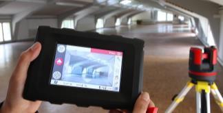
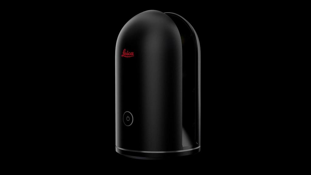
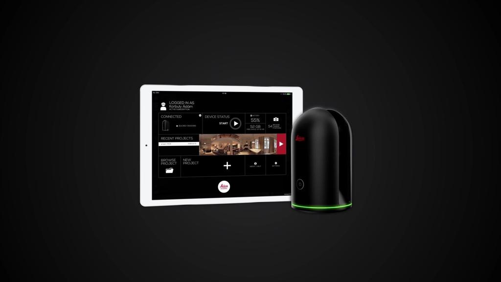
6 The new Leica BLK360 offers a new and effective entry point for laser scanning professionals The BLK360 is ideal for reality capture applications for BIM related projects 6


7 Leica Geosystems Built Environment BIM Vision We are striving to be the leading solution provider within the lifecycle of the Built Environment that intelligently captures and positions 3D information by offering a competitive advantage with our BIM solutions. We aim to be recognised as a trusted BIM advisor for construction companies. 7
8 Leica Geosystems Built Environment BIM Mission What we ll be doing Providing best in class solutions for enriching virtual constructible models and accurately capturing as built conditions of the Built Environment. How we ll do it By consultative selling, we will understand clients needs better; this involves the mapping of workflows and understanding the current tools and competencies within the clients organisation. We enable clients to become more efficient and productive through the development of the BIM opportunity. How we ll be different and competitive We continue to focus on BIM to Field and Field to BIM workflows. We will further develop our workflows with or without authoring software vendors. 8


9 INFORM Pre-Construction / As-Built ENRICH Construction Layout VALIDATE As-Built During Construction Model Reality Office Field 9
10 10
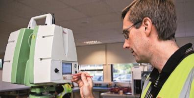


11 Leica Geosystems Built Environment INFORM: Renovation/FM As-Building Single Point Laser Distance Meter Multiple Points Discrete Point as-built Many Points Scan/Point Cloud 11


12 Inform Capture the as-built - Terrestrial Scan - Mobile Mapping - Aerial LIDAR - Topographical - Measured Building - Discrete Points - Measured Building - Space Survey - 3D Disto - Cable Detection - Buried Services - CCTV Survey - Asset Collection - Facilities Management 12


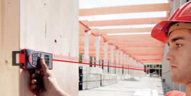
13 Leica Geosystems Built Environment ENRICH: Construction Layout Not a BIM Process All 2D Process AutoCAD LisCAD MS Layout BIM Process 3D to 2D Process BIM Process All 3D Process 13


14 Enrich Enrich the data - Stake-out/Layout - Facades - MEP Installation - Excavating - Grading - Earthmoving - Construction Monitoring - Asset Life Monitor - MEP Installation - Trade Tasks - Finishing 14

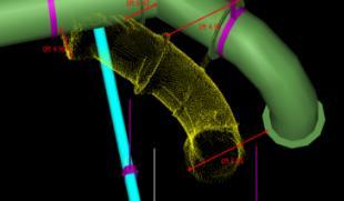
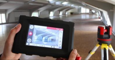
15 Leica Geosystems Built Environment VALIDATE: Quality Assurance [Deviation Detection] Laser Distance Meter Single Point Discrete Point checking Multiple Points Scan / Point Cloud Point Cloud 15


16 Validate Verify the as-constructed - Excavating - Grading - Earthmoving - Stake-out/Layout - Facades - MEP Installation - As-Constructed - Facilities Management - Terrestrial Scan - Mobile Mapping - Aerial LIDAR 16
17 17 BIG DATA LOADING

18 18


19 Leica Geosystems & Autodesk Alliance Formed to Transform Manufacturing & Engineering Industry Leader of Measurement Technologies Industry Leader of CAD & BIM 19
20 20
21 BLK360 imaging scanner Facts and Live Demo

22 22
23 Leica BLK360 Questions & Answers FAQs: BLK360 - What is it? What is in it? What can I use it for? How is it so small and light? How does it work? How does it fit into the Autodesk Workflow? How does it fit into Leica s HDS Workflows? 23
24 Leica BLK360 Questions & Answers BLK360 - What is it? Product Overview What Applications is it designed for 24
25 Leica BLK360 Product Overview - Hardware Scanner 360 Laser class 1 Single-Button IMU Internal memory 360 W-Lan antenna Panoramic Camera w LED flash Thermal Camera Battery compartment LED light guide 25
26 Leica BLK360 What Applications is it designed for? Reality Capture imaging/scanning applications at close ranges Image first approach / 3D data in the background 26
27 Leica BLK360 What Applications is it designed for? Reality Capture imaging/scanning applications at close ranges Image first approach / 3D data in the background 27
28 Leica BLK360 What Applications is it designed for? Reality Capture imaging/scanning applications at close ranges Image first approach / 3D data in the background?


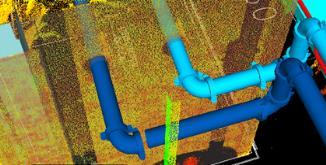
29 Leica BLK360 What Applications is it designed for - Examples Building Construction Crash Scene Documentation Renovation/Retrofit Shop Refurbishment 29
30 Leica BLK360 What s in the box? Standard delivery package Included Accessories Total Package 30

31 Leica BLK360 Standard Delivery Package 31


32 Leica BLK360 Standard Delivery Package BLK360 Imaging Scanner with protection hood and floorstand Battery Battery Charger - Quick Guide - Certificate - 12 mths warranty Autodesk ReCap Pro for Mobile 12 mths subscription 32


33 Leica BLK360 Standard Accessories Package BLK360 Bag BLK360 Tripod 2 Batteries + Charger 33
34 Leica BLK360 Why is it so small and light? Reduce to the max, e.g. Control is via external tablet, means no display Data transmission is purely wireless, means no cable connectors Heat is dissipated via metallic covers, means no active cooling system BLK360 is a pure sensor that collects raw data. The majority of processing is done on a tablet, means less processing onboard, less power, smaller battery, ultimately less size and weight. 34


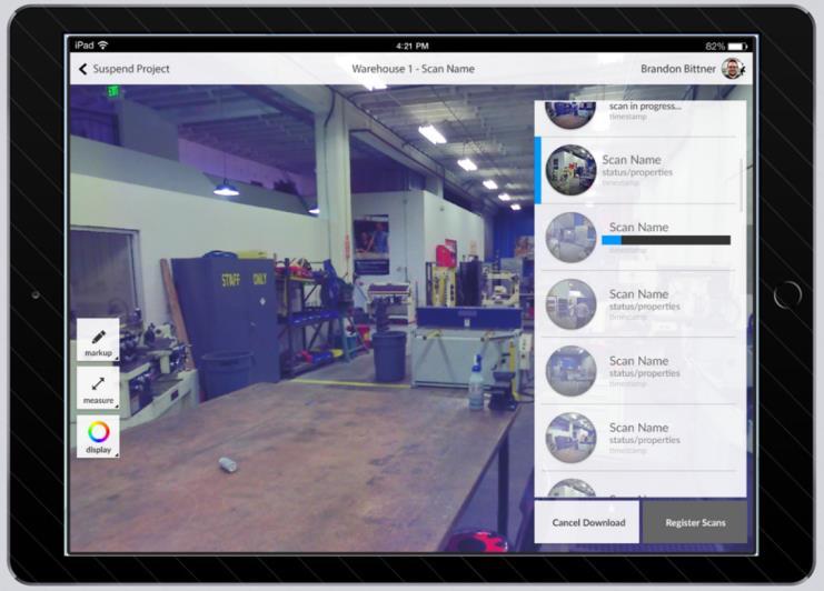
35 Leica BLK360 Technical Specifications Design & Physical Weight 1.1 kg Operating temp +5 to +40 C 165mm For indoor & outdoor use Anodized aluminum housing button-press quick release mechanical interface 100mm 35

36 Leica BLK360 Technical Specifications - Imaging 15 Mpixel 3-camera system LED flash support Calibrated spherical image 36
 panorama image")
37 Leica BLK360 Technical Specifications - Imaging 15 Mpixel 3-camera system LED flash support Calibrated spherical image Thermal Image overlay Latest FLIR Technology based Longwave Infrared (LWI) panorama image 37

38 Leica BLK360 Technical Specifications - Scanning 300 Full dome scan (65 Mio Pts) in < 2 min 3 predefined 7.5 m HighRes: 5 x 5 mm 360 Medium: 10 x 10 mm LowRes: 15 x 15 mm Distance range 0.5 to 60 m Range Precision < 4 15m Laser class 1 38

39 Leica BLK360 Technical Specifications additional Features Built in IMU Auto Tilt LED Light Guide 360 visible status indication WLAN 360 connectivity to ipad pro 64GB menu >100 scans Integrated / swappable battery 39

40 Leica BLK360 Measurement Workflow Once measurement is started First HDR spherical images are captured Image data transfer starts immediately Tablet SW starts processing and displaying spherical image Then 3D data is being captured Continuous transfer of raw data and processing on tablet Point cloud builds up in the background as data comes in Capturing is finished and data on the tablet is ready typically after 3min. 40

")

41 Leica BLK360 Measurement Workflow Options to transfer data from the tablet to the Office (1) WLAN (2) Flash Device (3) Cloud Storage Services LAN 41

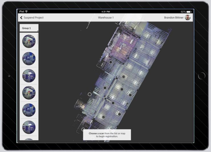
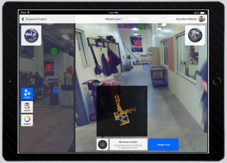
42 Leica BLK360 ReCap Pro for Mobile - Overview App Runs on ipad pro Downloadable from Apple App Store Bundled with Recap Pro Desktop version Follows Recap subscription model Functionality BLK360 Control View / Measure / Annotate Data Scan Registration Upload of Scan Data to ADSK Cloud 42


43 Leica BLK360 ReCap Pro for Mobile First Impressions 44


")


 Data is")


 Data can be")
44 Autodesk ReCap Pro for Mobile Workflow (1) Site is digitized with a BLK360 scanner controlled from the ipad Pro. Replac e (2) Collected scans are registered, measured and marked in the field. (3) Data is transferred to ReCap Pro desktop and published to the cloud. (4) Data can be synced with the cloud or used in Autodesk products.
45 Leica BLK360 Questions & Answers Does it fit into existing HDS workflows? Compatible with existing Leica Workflows Data can be processed to create deliverables from existing processes. Eg TruView & Jetstream. Modelled objects moved to Autodesk via COE (Cyclone Object Exchange) 46


46 Leica BLK360 Product Overview - Software ReCap Pro for Mobile Cyclone Register ReCap Pro 47
47 48

48
Leica BLK360 Questions & Answers. Vers
 Questions & Answers Vers. 11.01.2017 What is it? 2 What is it? 3 What is it? Calibrated full spherical image, LED flash support 4 What is it? 5 A new, simple way to capture reality Speed On-the-fly image
Reality Capture using: RPAS Technologies & Image Laser Scanners
 Reality Capture using: RPAS Technologies & Image Laser Scanners by Johan Erasmus (RPAS Technologies) & Barend Bornman (Image Laser Scanners) from Aciel Geomatics Laser Scanners High-Definition Surveying
CR Kennedy has established itself as one of the largest and most successful suppliers of Leica Geosystems survey equipment in the world.
 C.R. Kennedy was founded in 1934 by Clement Robertson Kennedy, importing photographic and optical products. In 1954 we became the first distributor in the world for Pentax - and today still the oldest.
Simplicity is the new black: The BLK360 story
 Simplicity is the new black: The BLK360 story Vanda KADLECIKOVA Leica Geosystems Heerbrugg, Switzerland E-mail: vanda.kadlecikova@leica-geosystems.com Abstract Meet the game changer. The new Leica BLK360
3D ponttechnológia használata napjainkban október. 10. Tatabány, Mérnöki továbbképzés Zeke Zsolt Mérnök üzletkötő
 3D ponttechnológia használata napjainkban 2018. október. 10. Tatabány, Mérnöki továbbképzés Zeke Zsolt Mérnök üzletkötő Leica BLK3D NEW based on photogrametry Leica HDS Termékportfólió BLK360 RTC360 P40/50
Leica ScanStation C10 The All-in-One Laser Scanner for Any Application
 The All-in-One Laser Scanner for Any Application Versatility, Productivity, Value Many organizations interested in laser scanning to diversify and/or improve current business have been waiting for a scanner
Leica High-Definition Surveying Systems. Leica HDS3000. The Industry Standard for High-Definition Surveying
 Leica High-Definition Surveying Systems Leica HDS3000 The Industry Standard for High-Definition Surveying HDS High-Definition Surveying TM : Laser Scanning Redefined High-Definition Surveying, or HDS,
The Leica HDS Family. The Right Tool for the Job HDS3000 HDS2500 HDS4500. Cyclone & CloudWorx. Press the QuickScan button to define the field-of-view.
 HDS2500 High accuracy scanner, ideal for fixed or raised installations when leveled tripod mounting is not practical, or areas with less stringent field-of-view requirements. The Leica HDS Family Time-of-flight
Trimble VISION Positions from Pictures
 Trimble VISION Positions from Pictures This session will cover What Is Trimble VISION? Trimble VISION Portfolio What Do you Need? How Does It Work & How Accurate Is It? Applications Resources Trimble VISION
Leica Pegasus: Backpack
 Leica Pegasus: Backpack Fast Acquisition Accurate data Indoor/Outdoor projects Pegasus:Backpack Simple workflow Everything, Everywhere 1 Leica Pegasus: Backpack Award Winning System Remarks Multiple Award
Leica DISTO S910 Measure point data and create plans
 Leica DISTO S910 Measure point data and create plans The world s first Measure anything from anywhere with P2P Technology It s been over 20 years since Leica Geosystems launched the first hand-held laser
Leica DISTO S910 Measure point data and create plans
 Leica DISTO S910 Measure point data and create plans The world s first Measure anything from anywhere with P2P Technology It s been over 20 years since Leica Geosystems launched the first hand-held laser
Leica ScanStation C5 Scalable Laser Scanner
 Leica ScanStation C5 Scalable Laser Scanner Leica ScanStation C5 Scalable from the Start Companies entering into laser scanning are often faced with inflexible and complex situations and would like a scalable
The Most Comprehensive Solution for Indoor Mapping Applications
 The Most Comprehensive Solution for Indoor Mapping Applications TRIMBLE INDOOR MOBILE MAPPING SOLUTION TRIMBLE INDOOR MOBILE MAPPING SOLUTION (TIMMS): HIGH EFFICIENCY, MAXIMUM FLEXIBILITY, ALL-IN-ONE PACKAGE
Increase Field Survey Efficiency by Merging Technologies in NOVA MultiStation. Vincent Lui Leica Geosystems Ltd
 Increase Field Survey Efficiency by Merging Technologies in NOVA MultiStation Vincent Lui Leica Geosystems Ltd Advantages of Laser Scanning Advantages of TPS Measurements Advantages of Imaging Advantages
Streamline your office to field processes. Peter Madsen
 2017 Streamline your office to field processes Peter Madsen Introduction Improving your office>field>office workflows and processes Data Preparation Data Upload Field Process Coding / Stringing Object
Leica Geosystems Release Notes
 Leica Geosystems Product Leica Cyclone REGISTER 360 version 1.5.0 Date 20 August 2018 From HDS Software Product Management Table of Contents WHAT S NEW... 3 Support for the new Leica RTC360 scanner...
3D Laser Scanner VS1000 User Manual
 3D Laser Scanner VS1000 User Manual 1 VS1000 Introduction SMART MAX GEOSYSTEMS CO., LTD VS1000 3D Laser Scanner based on pulses ranging principle, could quick acquire massive point cloud data from the
Suite en It Up with Autodesk ReCap
 Chad Studer ADSK Solutions RC3165 Static and mobile laser scanning technologies capture millions of points and provide photorealistic interactive virtual sites known as point clouds. With Autodesk ReCap
Protect by Leica Geosystems A Lifetime Guarantee
 Protect by Leica Geosystems A Lifetime Guarantee Protect by Leica Geosystems We always protect your success PROTECT by Leica Geosystems Lifetime Warranty No Cost Period Certified Quality Swiss Technology
Leica Geosystems Regional Public Safety Conference. Joshua Rayburn Consolidated Forensic Laboratory, Washington DC Present Date:
 Leica Geosystems Regional Public Safety Conference Joshua Rayburn Consolidated Forensic Laboratory, Washington DC Present Date: 04.15.15 2 What is a Pegasus? Portable survey-grade mobile mapping solution
Real world data collecting tools. Company Introduction. C2L equipment.co,.ltd
 Company Introduction C2L equipment.co,.ltd www.c2l-equipment.com Company Status Business Areas Company name C2L equipment.co,.ltd Address CEO Unit 603, Samwhan HIPEX B, Pangyo Station RD 230, Bundang,
Leica DISTO D1 Laser Distance Meter
 Leica DISTO D1 Laser Distance Meter Experience the difference! Page 1 of 5 At the touch of a button the Leica DISTO D1 measures heights, distances as well as niches quickly and reliably. Complicated or
Autodesk 360 in Design and Construction in the Cloud: A Pre-Flight Lab
 Autodesk 360 in Design and Construction in the Cloud: A Pre-Flight Lab IKERD Consulting LLC: Jerry Campbell VDC Consultant - Speaker IKERD Consulting LLC: Will Ikerd PE, CWI, LEED AP, Principal, President
KRISTAPS KLAVA - HEAD OF LASER SCANNING DEPARTMENT AT MERKO 3D LASER SCANNING POSSIBILITIES IN REAL ESTATE
 KRISTAPS KLAVA - HEAD OF LASER SCANNING DEPARTMENT AT MERKO 3D LASER SCANNING POSSIBILITIES IN REAL ESTATE Overview 1. What is laser scanning; 2. Technology; 3. End results of laser scanning; 4. Applications;
Leica Geosystems Measure, align, level
 Leica Geosystems Measure, align, level Increase your productivity measurably IN- DOOR Save time and money on any construction site: with the products from Leica Geosystems you can work fast, accurate and
Terrestrial 3D laser scanning Practical aspects
 Terrestrial 3D laser scanning Practical aspects ISPRS WG VI/5&SC Summer School 2007 by Gregor Bilban 3D laser scanning Benefits Lower data collection costs Reduction or elimination of re-visits More accurate
Leica Public Safety Solutions Versatile. Durable. Admissible
 Leica Public Safety Solutions Versatile. Durable. Admissible Public Safety Solutions 3D Laser Scanners Software Training and Consulting Services Leica ScanStation PS Series Professional Grade 3D Laser
Leica DISTO UP TO ANY TASK
 Leica DISTO UP TO ANY TASK Content Leica DISTO TM Accessories Technical data 4-19 20 21-22 2 When it has to be right outstanding measuring performance, built on decades of experience Leica Geosystems has
Leica Geosystems QuickStart Guide
 Leica Geosystems QuickStart Guide Product Leica Cyclone REGISTER 360 1.4.1 Date 3 January 2018 From HDS Software Product Management Contents Introduction... 2 Installation... 3 Licensing Setup... 4 Basic
/thermal-imaging THERMAL IMAGING THERMAL IMAGING
 1.800.323.0244 EDARLEY.COM/THERMAL-IMAGING BATTERIES THERMAL IMAGERS Shop TRUCK CHARGERS /thermal-imaging FLIR K45, K55 AND K65 CAMERA KITS NOW WITH FSX FSX real time digital processing results in ultra
Trimble UAS Portfolio Update. August 25 th 2015
 Trimble UAS Portfolio Update August 25 th 2015 Trimble UAS Portfolio Updates Trimble UX5 Setting the Standard in Mapping Trimble UX5 HP High Precision Surveying and Mapping Solution Trimble ZX5 Flexible
Leica Zeno GIS Equipment List
 Leica Zeno GIS Equipment List Table of Contents 1 Leica Zeno 10/Zeno 15 - GNSS/GIS Handhelds 3 2 GNSS Caps GS05 and GS06 for CS10 GIS & CS15 GIS 3 3 Packages 3 4 Additional Leica Zeno 10/Zeno 15 Options
3D SCANNING SERVICES FOR PUBLIC & PRIVATE CLIENTS
 Services provided include: 3D Scanning of Existing Structures & Equipment 3D Modeling for Current or Future Planning What can be scanned? Any 3-Dimensional Space Industrial Facilities Transshipment and
Geosystems Monday Hands-on Sessions
 Geosystems Monday Hands-on Sessions 1110: HDS University - Leica ScanStation P30/40 (and C10 & P20) Operation and Surveying Workflows (CEU eligible nominal fees will apply) The all new Leica ScanStation
HANDHELD MOBILE MAPPING / 3D LASER MAPPING SOLUTIONS. ZEB Family Brochure. geoslam.com
 HANDHELD MOBILE MAPPING / 3D LASER MAPPING SOLUTIONS ZEB Family Brochure geoslam.com NEW Long range, greater intensity, UAV ready HANDHELD BACKPACK UAV Effortless Data Capture Your tool to capture, view
Marc De Bruyne 3D Design Improvement Leader, DOW Chemical
 Marc De Bruyne 3D Design Improvement Leader, DOW Chemical John Foster Director, Profox Companies DOW Chemical Terneuzen in the Netherlands Globally, second largest DOW site after Freeport US. Producing
Trimble Indoor Mobile Mapping Solution
 Kevin Perkins Applanix Corp. NATIONAL SURVEYING, MAPPING & GEOSPATIAL CONFERENCE - MARCH 13-17, 2017 Trimble Indoor Mobile Mapping Solution Why Indoor Mapping? The need: As-built maps/models of indoor
Leica Cyclone 5.4 Technical Specifications
 Leica Cyclone 5.4 Technical Specifications HDS Scanner control and operation Scan Scan Scan Register Model Survey Viewer Acquire and display image Acquire image at specified resolution (high, medium, low)
Leica DISTO TM. The original laser distance meter
 Leica DISTO TM The original laser distance meter Why do you make your life so miserable? There is an alternative: Quick and efficient Just press the button and measure. One person measuring that saves
Trimble 3D Laser Scanning TRANSFORMING THE WAY THE WORLD WORKS
 Trimble 3D Laser Scanning Speed, Precision and Versatility Complete Solutions for Every Challenge CAPTURE AND DELIVER PRECISE DATA. FASTER. For scanning professionals, speed and precision are critical.
ROAD-SCANNER COMPACT APPLICATION FIELDS MAIN FEATURES
 ROAD-SCANNER COMPACT Mobile Mapping System by GEXCEL & SITECO collaboration A smaller mobile system for asset management and cartography suited for ZOLLER & FRÖHLICH PROFILER 9012 laser scanner. 2 + 3
Leica DISTO X4 Designed for bright, outdoor environments
 Leica DISTO X4 Designed for bright, outdoor environments Pointfinder camera The DISTO X4 is equipped with a Pointfinder camera allowing you to easily target distant objects in bright sunlight. Even if
Trimble Business Center Software, v3.30
 Trimble Business Center Software, v3.30 We are pleased to announce a new version of the Trimble Business Center software, version 3.30. This new version includes over 30 new features and enhancements increasing
Introducing. GeoSLAM. The experts in go anywhere 3D mobile mapping technology. The Company. The Technology. The Applications. Strategic Partnerships
 Introducing GeoSLAM The experts in go anywhere 3D mobile mapping technology The Company The Technology The Applications Strategic Partnerships The Company Multipurpose Presentation Template 2 About Us
QuickStart Guide: Leica Cyclone REGISTER 360
 Leica Geosystems QuickStart Guide: Cyclone REGISTER 360 Product Leica Cyclone REGISTER 360 1.4 Date 17 October 2017 From HDS Software Product Management Contents Introduction... 2 Installation... 3 Licensing
Gregory Walsh, Ph.D. San Ramon, CA January 25, 2011
 Leica ScanStation:: Calibration and QA Gregory Walsh, Ph.D. San Ramon, CA January 25, 2011 1. Summary Leica Geosystems, in creating the Leica Scanstation family of products, has designed and conducted
Leica Geosystems Release Notes
 Leica Geosystems Release Notes Product Leica TruView Enterprise 3.0 and TruView Cloud Date 17 th October 2017 From HDS Software Product Management Contents What s New... 2 Rebranding of TruView Global
LaCie 12big Thunderbolt 3. Clement Barberis
 LaCie 12big Thunderbolt 3 Clement Barberis Key Selling Points Professional 12-Bay Desktop RAID Storage LaCie 12big Thunderbolt 3 The Power to Think Big. Up to 96TB to protect immense amounts of hi-res
Leica ScanStation C10 Equipment List
 Leica ScanStation C10 Equipment List Table of Contents ScanStation C10 3 1 Scanner Set 3 Accessories for ScanStation C10 4 2 Accessory Set 4 3 Power Supply 4 3.1 Internal Power Supply 4 3.2 External Power
Rapid Building information modeling. Ivar Oveland 2013
 Rapid Building information modeling Ivar Oveland 2013 Case study How can I rapidly create a building information model? Today: Different methods are used today to establish a building information model
Workshop. Dr. Denis Wohlfeld Innovation Manager P l a n t S i m u l a t i o n U s e r C o n f e r e n c e
 Workshop 3D Laser Scan PlantSimulation Dr. Denis Wohlfeld Innovation Manager 2 0 1 6 P l a n t S i m u l a t i o n U s e r C o n f e r e n c e GLOBAL FARO SITES W o r l d l e a d e r i n c o m p u t e
Shaping the World with Leica Zeno GIS Asset Collection & Management
 Shaping the World with Leica Zeno GIS Asset Collection & Management Edward Toh GIS Segment Manager, APAC Agenda Power of Geography Location bring values Case Studies Integration of Surveyors into GIS Leica
DRONE MAPPING FOR CONSTRUCTION
 DRONE MAPPING FOR CONSTRUCTION POWERFUL SOLUTIONS FOR AS-BUILT SURVEYS AND SITE DOCUMENTATION - AUTOMATED FLEXIBLE PROCESSING - REPEATABLE RELIABLE ACCURACY - APPLICABLE RESULTS WE CAPTURE IMAGES FROM
Leica TruView Technical Specifications
 Leica TruView Technical Specifications Valid as of October 2018 leica-geosystems.com Deployment TruView Local TruView Enterprise TruView Cloud Runs independent of a server (Internet Explorer ActiveX Plugin
Overview of the Trimble TX5 Laser Scanner
 Overview of the Trimble TX5 Laser Scanner Trimble TX5 Revolutionary and versatile scanning solution Compact / Lightweight Efficient Economical Ease of Use Small and Compact Smallest and most compact 3D
GeoSLAM Overview. The experts in go-anywhere 3D mobile mapping technology
 GeoSLAM Overview The experts in go-anywhere 3D mobile mapping technology 1 About GeoSLAM The experts in go-anywhere 3D mobile mapping technology 2 Who We Are GeoSLAM is a global market leader in go-anywhere
technical notes trimble business center software
 technical notes trimble business center software A POWERFUL SURVEY DATA OFFICE SOFTWARE SUITE DESIGNED FOR TODAY'S FAST-PACED SURVEYING OFFICE, TRIMBLE BUSINESS CENTER SOFTWARE UNLOCKS THE POTENTIAL OF
UAVs & IMAGES ACCESSORIES ABOUT GEXCEL
 LIDAR SOFTWARE UAVs & IMAGES MONITORING MOBILE MAPPING ACCESSORIES OTHER ABOUT GEXCEL BUSINESS TEAM LOCATIONS Gexcel offices are located in Italy in two Innovation Centers SALES NETWORK Gexcel s worldwide
Virtually Real: Terrestrial Laser Scanning
 Check. They re Chartered. Geomatics Client Guides Virtually Real: Terrestrial Laser Scanning Understanding an evolving survey technology Summary This guide gives you an overview of the technique, some
Technical Data. FLIR T640bx 45 (incl. Wi-Fi)
") Technical Data FLIR T640bx 45 (incl. Wi-Fi) Part number: 55901-0603 Copyright 2012, FLIR Systems, Inc. All rights reserved worldwide. Names and marks appearing herein are either registered trademarks or
Technical Data FLIR T640bx 45 (incl. Wi-Fi) Part number: 55901-0603 Copyright 2012, FLIR Systems, Inc. All rights reserved worldwide. Names and marks appearing herein are either registered trademarks or
Technical Data FLIR E40 (incl. Wi-Fi)
") Technical Data FLIR E40 (incl. Wi-Fi) Part number: 49001-0301 Copyright 2012, FLIR Systems, Inc. Names and marks appearing herein are either registered trademarks or trademarks of FLIR Systems and/or its
Technical Data FLIR E40 (incl. Wi-Fi) Part number: 49001-0301 Copyright 2012, FLIR Systems, Inc. Names and marks appearing herein are either registered trademarks or trademarks of FLIR Systems and/or its
in accordance with ISO Leica DISTO D410/D510 The original laser distance meter
 We keep our promises in accordance with ISO 16331-1 Leica DISTO D410/D510 The original laser distance meter Accuracy & range Colour display and digital Pointfinder with 4x zoom Precise targeting and measuring
3D Laser Scanning Technology. Fast, Safe, Accurate. Rugged hardware and powerful software combined with streamlined survey workflow
 3D Laser Scanning Technology Fast, Safe, Accurate Rugged hardware and powerful software combined with streamlined survey workflow Maptek specialises in the research, development and application of 3D laser
JANUARY 2017 WATER S END. Mobile Mapping. Station to Station. Decided Guidance Indoor application. Implementing BIM. A fixed boundary R E YEARS
 JANUARY 2017 WATER S END Mobile Mapping Station to Station Decided Guidance Indoor application Implementing BIM A fixed boundary R LEB ATING E C 30 YEARS Indoor Mobile Mapping A unique approach to interior
Leica DISTO X3 Designed for tough, rugged conditions
 Leica DISTO X3 Designed for tough, rugged conditions The rugged Leica DISTO X-series combines innovative measuring technologies with a site-proof design and simple user interface. Together with the Leica
White Paper. Inside Trimble TX6 and TX8 Color Acquisition. Prepared by Gregg Jackson and Gregory Lepere. ABSTRACT
 White Paper Inside Trimble TX6 and TX8 Color Acquisition Prepared by Gregg Jackson and Gregory Lepere www.trimble.com/3dscanning ABSTRACT With the release of the new Trimble TX6 and TX8, Trimble introduced
Leica DISTO D110 Laser Distance Meter
 Page 1 of 5 Leica DISTO D110 Laser Distance Meter Small size, big possibilities The new Leica DISTO D110 is the first laser distance meter with Bluetooth Smart that fits to a pocket. Its handy design with
Leica Viva Imaging Enrich your Surveying Workflow
 Leica Viva Imaging Enrich your Surveying Workflow Your Vision: Images that Welcome to Leica Viva Imaging Enrich your Surveving Workflow Leica Viva Imaging enriches your surveying workflow with visual documentation
POINT CLOUD based REVERSE ENGINEERING. Young-Ho Chai, Ph.D
 POINT CLOUD based REVERSE ENGINEERING Young-Ho Chai, Ph.D 3D Spatial Survey Workflow Hardware Requirements Phase Based Laser Scanner: -Leica ScanStation P20 x 1EA -Usage: Short-range, ~80m Time of Flight
IP-S2 HD. High Definition 3D Mobile Mapping System
 IP-S2 HD High Definition 3D Mobile Mapping System Integrated, turnkey solution Georeferenced, Time-Stamped, Point Clouds and Imagery High Density, Long Range LiDAR sensor for ultimate in visual detail
Leica Geosystems Release Notes
 Leica Geosystems Release Notes Product Cyclone REGISTER 360 Version 1.4 Date 17 th October 2017 From HDS Software Product Management Contents INTRODUCTION...2 FEATURES...2 COMPUTER SPECIFICATIONS...2 Minimum
Integrated Field to Finish BIM for Surveyors. Boris Skopljak Market Manager, Trimble Geospatial Office Software
 Integrated Field to Finish BIM for Surveyors Boris Skopljak (boris_skopljak@trimble.com) Market Manager, Trimble Geospatial Office Software Agenda Trimble Introduction BIM relevance in Trimble Trimble
APPLE IPHONE 5 CHARGER CABLE
 24 October, 2017 APPLE IPHONE 5 CHARGER CABLE Document Filetype: PDF 471.75 KB 0 APPLE IPHONE 5 CHARGER CABLE Apple Lightning to USB Cable. 3.5 / 5 (39 Reviews). Free delivery and returns on eligible orders.
E-Series bx. FLIR E-Series bx Thermal Imaging Cameras. Revolutionary Performance. Superior Point & Shoot Thermal Imagery
 FLIR E-Series bx Thermal Imaging Cameras E-Series bx Revolutionary Performance Superior Point & Shoot Thermal Imagery Built-in Digital Camera & Laser Pointer Mobile Device Wi-Fi Connectivity Large Bright
Technical Data FLIR E60 (incl. Wi-Fi)
") Technical Data FLIR E60 (incl. Wi-Fi) Part number: 49001-0602 Copyright 2012, FLIR Systems, Inc. Names and marks appearing herein are either registered trademarks or trademarks of FLIR Systems and/or its
Technical Data FLIR E60 (incl. Wi-Fi) Part number: 49001-0602 Copyright 2012, FLIR Systems, Inc. Names and marks appearing herein are either registered trademarks or trademarks of FLIR Systems and/or its
Leica Disto D2 Laser Distance Measurer / Range Finder
 Leica 762200 Disto D2 Laser Distance Measurer / Range Finder MRP Rs.11,500 Free Home Delivery Offer Price Rs.5,000 Inclusive of Taxes Save Rs.6,500 3 Years Replacement Article No.762200 Description Measuring
The smartest solution to measuring and documenting
 Page 1 of 5 Leica DISTO D810 Laser Distance Meter The smartest solution to measuring and documenting World s first: The Leica DISTO D810 touch is the first laser distance meter world-wide with a touch
E-Series bx. FLIR E-Series bx Thermal Imaging Cameras. Revolutionary Performance. Superior Point & Shoot Thermal Imagery
 FLIR E-Series bx Thermal Imaging Cameras E-Series bx Revolutionary Performance Superior Point & Shoot Thermal Imagery Built-in Digital Camera & Laser Pointer Mobile Device Wi-Fi Connectivity Large Bright
Hardware 3D Mapping Systems
 Hardware 3D Mapping Systems About Us GreenValley International GreenValley International provides 3D mapping solutions that include mobile & aerial LiDAR acquisition hardware, post-processing software
Comparative study on the differences between the mobile mapping backpack systems ROBIN- 3D Laser Mapping, and Pegasus- Leica Geosystems.
 3 th Bachelor Real Estate, Land Surveying Measuring Methods III Comparative study on the differences between the mobile mapping backpack systems ROBIN- 3D Laser Mapping, and Pegasus- Leica Geosystems.
Technical Data. FLIR T (incl. Wi-Fi) Imaging and optical data
 Imaging and optical data") Technical Data FLIR T620 25 (incl. WiFi) Part number: 559010102 Copyright 2012, FLIR Systems, Inc. All rights reserved worldwide. Names and marks appearing herein are either registered trademarks or trademarks
Technical Data FLIR T620 25 (incl. WiFi) Part number: 559010102 Copyright 2012, FLIR Systems, Inc. All rights reserved worldwide. Names and marks appearing herein are either registered trademarks or trademarks
DATASHEET Pepwave Mesh Connector
 Features Vendor Neutral Repeater, Interoperability Certified The allows you to seamlessly extend the coverage of an existing Wi-Fi network, without messy configurations or having to run cables! Simply
Italian pavilion in 3D, project for EXPO 2015, Milan (Italy) JRC 3D RECONSTRUCTOR POWERFUL. ADVANCED. PROFESSIONAL
 JRC 3D RECONSTRUCTOR POWERFUL. ADVANCED. PROFESSIONAL") Italian pavilion in 3D, project for EXPO 2015, Milan (Italy) JRC 3D RECONSTRUCTOR POWERFUL. ADVANCED. PROFESSIONAL OVERVIEW JRC 3D Reconstructor is the well known multi-platform and multi-resolution software
Italian pavilion in 3D, project for EXPO 2015, Milan (Italy) JRC 3D RECONSTRUCTOR POWERFUL. ADVANCED. PROFESSIONAL OVERVIEW JRC 3D Reconstructor is the well known multi-platform and multi-resolution software
T-SERIES UNLEASH THE ULTIMATE POWER OF FLIR. thermal IMAGING CAMERAS FoR PREDICtIVE MAINtENANCE
 T-SERIES thermal IMAGING CAMERAS FoR PREDICtIVE MAINtENANCE UNLEASH THE ULTIMATE POWER OF FLIR T-SERIES the ultimate thermal IMAGER PRoDuCtIVItY boost Touchscreen tools as intuitive as a smartphone s Simple
RIEGL VZ-400i. Digital Information in 3D Innovations and Best Practises. 4th to 5th of November, Prince Philip House, London
 RIEGL VZ-400i Digital Information in 3D Innovations and Best Practises 4th to 5th of November, Prince Philip House, London London Thames Sunset panorama by Diliff - CC BY 3.0 continuous developments on
Scan-to-BIM. NEWBIM ApS, Galina Slavova CEO, BIM Specialist
 Scan-to-BIM NEWBIM ApS, Galina Slavova CEO, BIM Specialist Agenda What is Building Information Modeling (BIM) About NEWBIM ApS 3D Laser Scanning Integration Case Study Demonstration Building Information
BIM + Design Technology HDR, Inc., all rights reserved.
 BIM + Design Technology 2014 HDR, Inc., all rights reserved. HDR Profile HDR is a creative firm for architecture and engineering with experience spanning over 40 years in the Australian market. With more
On Grid: Tools and Techniques to Place Reality Data in a Geographic Coordinate System
 RC21940 On Grid: Tools and Techniques to Place Reality Data in a Geographic Coordinate System Seth Koterba Principal Engineer ReCap Autodesk Ramesh Sridharan Principal Research Engineer Infraworks Autodesk
FARO As-Built for AutoCAD Software Versatile Reality to CAD Solutions
 FARO As-Built for AutoCAD Software Versatile Reality to CAD Solutions FARO As-Built for Autodesk Revit Creating Efficiencies in Scan Data Extraction for BIM FARO As-Built for AutoCAD Software TM Versatile
BEFORE YOU BUY: SEVEN CRITICAL QUESTIONS TO ASK ABOUT LASER SCANNERS. Robert Gardiner
 BEFORE YOU BUY: SEVEN CRITICAL QUESTIONS TO ASK ABOUT LASER SCANNERS Robert Gardiner Table of Contents Introduction... 3 Horizontal and Vertical Angular Accuracies... 4 Movement Tracking... 6 Range Limitations...
HIGH-DEFINITION SURVEY AND BIM PRESENTATION FOR BIM-MEP AUS
 www.aamgroup.com/bim HIGH-DEFINITION SURVEY AND BIM PRESENTATION FOR BIM-MEP AUS Matt Rumbelow, B.Arch AAM BIM Coordinator ABOUT AAM Reality Captured. Certainty Delivered Reality Captured. Certainty Delivered
Reality Capture: From Point Cloud To Design To Visualisation. by Shuaib Yunos, Baker Baynes
 Reality Capture: From Point Cloud To Design To Visualisation by Shuaib Yunos, Baker Baynes Perspective: Design & Construction Designers are conceiving buildings differently. Building owners expect a lot
Product Overview Leica Geosystems Asset Collection & Management Segment Brett Black GIS Sales & Support Manager
 Product Overview Leica Geosystems Asset Collection & Management Segment Brett Black GIS Sales & Support Manager Outline Market Segments & Application Areas GIS Hardware Solutions Overview Leica GIS Asset
T-SERIES THERMAL IMAGING CAMERAS FOR PREDICTIVE MAINTENANCE UNLEASH THE ULTIMATE POWER OF FLIR
 T-SERIES THERMAL IMAGING CAMERAS FOR PREDICTIVE MAINTENANCE UNLEASH THE ULTIMATE POWER OF FLIR T-SERIES THE ULTIMATE THERMAL IMAGER PRODUCTIVITY BOOST Touchscreen tools as intuitive as a smartphone s Simple
Mobile Mapping with the Road-Scanner in France Hi-grade 1:200 scale mapping
 FARO USER CONFERENCE APRIL 27-28 2014 Mobile Mapping with the Road-Scanner in France Hi-grade 1:200 scale mapping 03/04/2014 ing. Augusto Burchi burchi@sitecoinf.it Siteco's profile Founded in 2000 as
ALL-IN-ONE DRONE SOLUTION FOR 3D MODELING
 ALL-IN-ONE DRONE SOLUTION FOR 3D MODELING Powered by PHOTO & VIDEO FULL HD 1080P - 14MPX 3-AXIS STABILIZATION AUGMENTED POWER 30MIN FLIGHT TIME 32GB INTERNAL MEMORY INCLUDES 3D MODELING SOFTWARE SAFE VIEW
leica-geosystems.com Leica Geosystems World leader in spatial measurement
 leica-geosystems.com Leica Geosystems World leader in spatial measurement No matter the task, scope or environment, Leica Geosystems supplies the solutions that help professionals get it right. Trust.
Bringing Singapore to life in 3D
 Bringing Singapore to life in 3D Dr Victor Khoo, Deputy Director Singapore Land Authority Bringing Singapore to life in 3D ESRI Singapore UC 2016 Dr. Victor Khoo Singapore Land Authority SLA 2016 RESTRICTED
Leica Absolute Tracker AT401 Absolutely portable
 www.leica-geosystems.com/metrology Leica Absolute Tracker AT401 Absolutely portable Leica Absolute Tracker Absolutely portable» The Leica Absolute Tracker AT401 is a portable coordinate measuring machine