Remote Sensing Sensor Integration
|
|
|
- Irene Atkinson
- 6 years ago
- Views:
Transcription


1 Remote Sensing Sensor Integration Erica Tharp LiDAR Supervisor
2 Table of Contents About 3001 International Inc Remote Sensing Platforms Why Sensor Integration? Technical Aspects of Sensor Integration Limitations of Sensor Integration Benefits of Sensor Integration


 Supply Chain Management Lead Support")
3 Operating Sectors Aerospace Systems Electronic Systems Information Systems Shipbuilding Technical Services Large Scale Systems Integration C 4 ISR Unmanned Systems Airborne Ground Surveillance / C2 Naval BMC2 Global / Theater Strike Systems Electronic Combat Operations ISR Satellite Systems Missile Defense Satellite Systems MILSATCOM Systems Environmental & Space Science Satellite Systems Directed Energy Systems Radar Systems C 4 ISR Electronic Warfare Naval & Marine Systems Navigation & Guidance Military Space Government Systems Command & Control Systems Network Communications Intelligence, Surveillance & Reconnaissance Systems Enterprise Systems and Security IT/Network Outsourcing Intelligence Federal, State/Local & Commercial Homeland Security & Health Naval Systems Integrator Surface Combatants Expeditionary Warfare Ships Auxiliary Ships Marine Composite Technology Coast Guard Cutters Commercial Ships Nuclear Aircraft Carriers Nuclear Submarines Fleet Maintenance Aircraft Carrier Overhaul & Refueling Systems Support Base and Infrastructure Support Range Operations Maintenance Support Training and Simulations Technical and Operational Support Live, Virtual and Constructive Domains Life Cycle Optimization Performance Based Logistics Modifications, Repair and Overhaul (MRO) Supply Chain Management Lead Support Integrator (LSI) Strategic Space Systems

4 3001 Civil Works Offices
 Seamless strip imagery along each flight line Three sensors in one - panchromatic, color and false color")
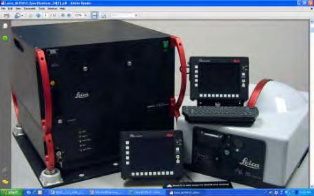
5 Orthophotography 2 Zeiss DMC (Digital Mapping Camera System) Frame based sensor 4 panchromatic & 4 RGB-IR camera heads Availability of multi-spectral information Fully automated workflow Forward motion compensation -> Resolutions > 5cm 3 Leica ADS60 Push broom sensor (line scanning) Seamless strip imagery along each flight line Three sensors in one - panchromatic, color and false color sensors at 3 different angles Reduced ground control requirements No FMC -> Resolutions > 10 cm 2 Rollei AIC Shutter speed of 1/1000 th second Stable one-piece aluminum alloy body for enhanced endurance in aerial applications 4 second cycle time Built in light sensor Aspect ratio of 3:4
 FOV up to 50 Optech Gemini Operational altitude")
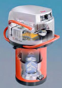
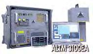
6 LiDAR Systems Leica ALS50 II Planimetric spacing with an accuracy of 11cm Operational altitude of m AGL 4 return detection system (1st, 2nd, 3rd, and last) Pulse rates up to 150kHz FOV up to 75 Optech 3100 Operational altitude of m AGL khz programmable laser repetition rate 4 return detection system (1st, 2nd, 3rd, and last) FOV up to 50 Optech Gemini Operational altitude of m AGL 167 khz laser repetition rate 4 return detection system (1st, 2nd, 3rd, and last) FOV up to 50 62% increase in data coverage and effective collection rate 6

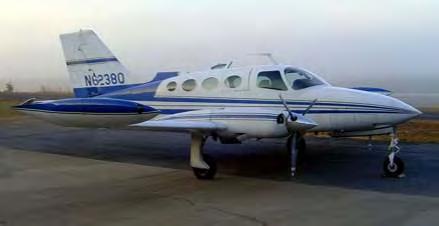
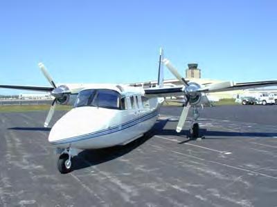
7 Airborne Platforms & Sensors


8 Why the need for sensor integration? Time Differences between the imagery and topographic data differences evident in areas of construction, agriculture, etc. Money Cost of acquiring multiple data sets Multiple lifts Double the fuel and crew 8


9 Why the need for sensor integration?
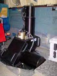
10 Technical Aspects of Sensor Integration The Optech Gemini and RolleiMetric s AIC modular LS medium format camera have been integrated sharing the same housing, IMU and airborne GPS. The maximum point density that can be achieved is 10 points per ^2m at 1000ft AGL, 15deg FOV and 70 KHz, this varies greatly depending on flying height and speed. The Rollei comes equipped with: 2 super angulon 50mm F/2.8 a pixel size of 9 microns maximum exposure rate of 4 seconds an automatic aperture mode with the shutter priority when the light meter is used
11 Technical Aspects of Sensor Integration There is a 3:5 ratio of overlap with the LiDAR and the Rollei. Therefore, if the LiDAR is planned with 30% overlap the Rollei images will have 50% overlap. The field of view on the Rollei opens up to 45 so any LiDAR flight plan with up to a 45 FOV the imagery will align properly. The imagery acquisition is based on the LiDAR flight plan. The forward lap of the imagery is calculated in real time using the LiDAR. As the elevation increases the image spacing becomes tighter.
12 Limitations of Sensor Integration Due to the limitations of the imagery acquisition can only occur during certain hours of the day Integration does not decrease the survey work The Rollei produces 2.7 more frames than the DMC, which then have to be stitched together The LiDAR processing efforts are enhanced but not reduced due to the imagery
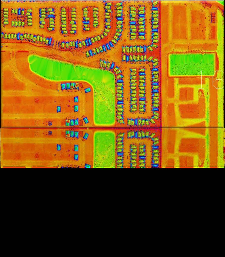
13 Benefits of Sensor Integration The LiDAR model is used to ortho-rectify imagery The imagery enhances the creation of breaklines Feature detection is enhanced due to the use of the two simultaneously acquired topographic and visual data sets May provide easier access to restricted airspace since you will only have to enter the airspace once to collect both data sets Reduces air traffic control headaches 13
 14")
14 Benefits of Sensor Integration Both the imagery and the LiDAR can be used independently, together as overlays in a GIS, or to fuse the two into a single LAS format data set where the RGB values from the imagery are combined with the LiDAR X,Y,Z values Helps to monitor the progression of dynamic landforms i.e. coastlines, forestry, faults etc. Provides quick overviews of emergency situations i.e. Hurricanes, tornados Reduction in mobilization costs (fuel, maintenance, crew) 14

15 Emergency Response.

16 Summary So with the Optech Gemini and the Rollei AIC 3001inc can offer high resolution spatial data products of exceptional quality at a reduced cost.

17 3001, A Northrop Grumman Company 17
Structural Analysis Tools. Modernization
 Structural Analysis Tools David Fowler Modernization Section Manager, Bethpage Structural Analysis Northrop Grumman Northrop Grumman Structural Analysis Tools Modernization NX CAE Symposium Fall 2012 David
An Introduction to Lidar & Forestry May 2013
 An Introduction to Lidar & Forestry May 2013 Introduction to Lidar & Forestry Lidar technology Derivatives from point clouds Applied to forestry Publish & Share Futures Lidar Light Detection And Ranging
Mayden VP of Business Development Surdex Corporation
 Making Sense of Sensors Randy Mayden, Mayden VP of Business Development Surdex Corporation randym@surdex.com EARLYAERIAL PHOTOGRAPHY 2 FIRSTAERIAL CAMERA 3 AERIAL CAMERA SYSTEM DEVELOPMENT Aerial Camera
Terrestrial GPS setup Fundamentals of Airborne LiDAR Systems, Collection and Calibration. JAMIE YOUNG Senior Manager LiDAR Solutions
 Terrestrial GPS setup Fundamentals of Airborne LiDAR Systems, Collection and Calibration JAMIE YOUNG Senior Manager LiDAR Solutions Topics Terrestrial GPS reference Planning and Collection Considerations
Aerial and Mobile LiDAR Data Fusion
 Creating Value Delivering Solutions Aerial and Mobile LiDAR Data Fusion Dr. Srini Dharmapuri, CP, PMP What You Will Learn About LiDAR Fusion Mobile and Aerial LiDAR Technology Components & Parameters Project
Quinnipiac Post Flight Aerial Acquisition Report
 Quinnipiac Post Flight Aerial Acquisition Report August 2011 Post-Flight Aerial Acquisition and Calibration Report FEMA REGION 1 Quinnipiac Watershed, Connecticut, Massachusesetts FEDERAL EMERGENCY MANAGEMENT
ISPRS Com1 Update Airborne Sensor Systems. Arthur Rohrbach SGPBF meeting, RSL, Fall 2006
 ISPRS Com1 Update Airborne Sensor Systems Arthur Rohrbach SGPBF meeting, RSL, Fall 2006 Significant Meetings / News (for Sensor Systems) 1/2 ASPRS, Reno, USA (May-06) Vexcel, Austria Leica, Switzerland
High resolution survey and orthophoto project of the Dosso-Gaya region in the Republic of Niger. by Tim Leary, Woolpert Inc.
 High resolution survey and orthophoto project of the Dosso-Gaya region in the Republic of Niger by Tim Leary, Woolpert Inc. Geospatial Solutions Photogrammetry & Remote Sensing LiDAR Professional Surveying
Leica Systems Overview
 RC30 AERIAL CAMERA SYSTEM Leica Systems Overview The Leica RC30 aerial film camera is the culmination of decades of development, started with Wild's first aerial camera in the 1920s. Beautifully engineered
Leica ALS70. Airborne Laser Scanners Performance for diverse Applications
 Leica ALS70 Airborne Laser Scanners Performance for diverse Applications Three Models, One Result. Highest Productivity in all Applications. Imagine an affordable 500 khz pulse rate city-mapping LIDAR
Sensor Fusion: Potential, Challenges and Applications. Presented by KVH Industries and Geodetics, Inc. December 2016
 Sensor Fusion: Potential, Challenges and Applications Presented by KVH Industries and Geodetics, Inc. December 2016 1 KVH Industries Overview Innovative technology company 600 employees worldwide Focused
Airborne Laser Survey Systems: Technology and Applications
 Abstract Airborne Laser Survey Systems: Technology and Applications Guangping HE Lambda Tech International, Inc. 2323B Blue Mound RD., Waukesha, WI-53186, USA Email: he@lambdatech.com As mapping products
Orthophotography and LiDAR Terrain Data Collection Rogue River, Oregon Final Report
 Orthophotography and LiDAR Terrain Data Collection Rogue River, Oregon Final Report Prepared by Sky Research, Inc. 445 Dead Indian Memorial Road Ashland, OR 97520 Prepared for Rogue Valley Council of Governments
Leica ALS80 Airborne Laser Scanners Performance for every Application
 Leica ALS80 Airborne Laser Scanners Performance for every Application Three Models, One Result. Highest Productivity in all Applications. Imagine an affordable city-mapping LIDAR system with an industry-leading
LiDAR & Orthophoto Data Report
 LiDAR & Orthophoto Data Report Tofino Flood Plain Mapping Data collected and prepared for: District of Tofino, BC 121 3 rd Street Tofino, BC V0R 2Z0 Eagle Mapping Ltd. #201 2071 Kingsway Ave Port Coquitlam,
Newest Technologies for Compact Aerial Survey Cameras
 Newest Technologies for Compact Aerial Survey Cameras Tobias Tölg CEO t.toelg@rollei-metric.com RolleiMetric Systempartner of - Rollei Metric GmbH - AIC History and Present - AICxN - Conclusion and Prospects
2010 LiDAR Project. GIS User Group Meeting June 30, 2010
 2010 LiDAR Project GIS User Group Meeting June 30, 2010 LiDAR = Light Detection and Ranging Technology that utilizes lasers to determine the distance to an object or surface Measures the time delay between
Great Stories Start Here at HxGN LIVE 04/07/10: EDIT OR DELETE THIS IN THE MASTER > SLIDE MASTER UNDER THE INSERT MENU.
 Great Stories Start Here at HxGN LIVE 04/07/10: EDIT OR DELETE THIS IN THE MASTER > SLIDE MASTER UNDER THE INSERT MENU. Geosystems at HxGN LIVE Transitioning from Frame to Pushbroom Cameras Craig Molander
Trends in Digital Aerial Acquisition Systems
 Trends in Digital Aerial Acquisition Systems Ernest Yap Regional Sales Manager, Airborne-Americas eyap@applanix.com 1 Medium Format Digital Cameras Medium Format Digital Cameras Where does the Medium
LiDAR data pre-processing for Ghanaian forests biomass estimation. Arbonaut, REDD+ Unit, Joensuu, Finland
 LiDAR data pre-processing for Ghanaian forests biomass estimation Arbonaut, REDD+ Unit, Joensuu, Finland Airborne Laser Scanning principle Objectives of the research Prepare the laser scanning data for
Integrated Multi-Source LiDAR and Imagery
 Figure 1: AirDaC aerial scanning system Integrated Multi-Source LiDAR and Imagery The derived benefits of LiDAR scanning in the fields of engineering, surveying, and planning are well documented. It has
Airborne LiDAR Surveys and Data Delivery in the Pipeline Industry
 Airborne LiDAR Surveys and Data Delivery in the Pipeline Industry Carlos Femmer Faron Olivier October 25, 2011 October 25, 2011 GITA GIS for Oil and Gas Pipeline 2011 Organization Fugro is a decentralized
CLASSIFICATION OF NONPHOTOGRAPHIC REMOTE SENSORS
 CLASSIFICATION OF NONPHOTOGRAPHIC REMOTE SENSORS PASSIVE ACTIVE DIGITAL CAMERA THERMAL (e.g. TIMS) VIDEO CAMERA MULTI- SPECTRAL SCANNERS VISIBLE & NIR MICROWAVE HYPERSPECTRAL (e.g. AVIRIS) SLAR Real Aperture
Leica - Airborne Digital Sensors (ADS80, ALS60) Update / News in the context of Remote Sensing applications
 Update / News in the context of Remote Sensing applications") Luzern, Switzerland, acquired with GSD=5 cm, 2008. Leica - Airborne Digital Sensors (ADS80, ALS60) Update / News in the context of Remote Sensing applications Arthur Rohrbach, Sensor Sales Dir Europe,
Luzern, Switzerland, acquired with GSD=5 cm, 2008. Leica - Airborne Digital Sensors (ADS80, ALS60) Update / News in the context of Remote Sensing applications Arthur Rohrbach, Sensor Sales Dir Europe,
Overview of the Trimble TX5 Laser Scanner
 Overview of the Trimble TX5 Laser Scanner Trimble TX5 Revolutionary and versatile scanning solution Compact / Lightweight Efficient Economical Ease of Use Small and Compact Smallest and most compact 3D
Lecture 11. LiDAR, RADAR
 NRMT 2270, Photogrammetry/Remote Sensing Lecture 11 Calculating the Number of Photos and Flight Lines in a Photo Project LiDAR, RADAR Tomislav Sapic GIS Technologist Faculty of Natural Resources Management
An Overview of Applanix.
 An Overview of Applanix The Company The Industry Leader in Developing Aided Inertial Technology Founded on Canadian Aerospace and Defense Industry Expertise Providing Precise Position and Orientation Systems
Mobile LiDAR for Ground Applications. Spar 2006, March Paul Mrstik, Terrapoint Canada Inc. Craig Glennie, Terrapoint USA LLC
 Mobile LiDAR for Ground Applications Spar 2006, March 27 2006 Paul Mrstik, Terrapoint Canada Inc. Craig Glennie, Terrapoint USA LLC Agenda Introduction to Terrapoint What is mobile LiDAR? Advantages of
Airborne LiDAR Data Acquisition for Forestry Applications. Mischa Hey WSI (Corvallis, OR)
") Airborne LiDAR Data Acquisition for Forestry Applications Mischa Hey WSI (Corvallis, OR) WSI Services Corvallis, OR Airborne Mapping: Light Detection and Ranging (LiDAR) Thermal Infrared Imagery 4-Band
Airborne LiDAR Data Acquisition for Forestry Applications Mischa Hey WSI (Corvallis, OR) WSI Services Corvallis, OR Airborne Mapping: Light Detection and Ranging (LiDAR) Thermal Infrared Imagery 4-Band
The Applanix Approach to GPS/INS Integration
 Lithopoulos 53 The Applanix Approach to GPS/INS Integration ERIK LITHOPOULOS, Markham ABSTRACT The Position and Orientation System for Direct Georeferencing (POS/DG) is an off-the-shelf integrated GPS/inertial
MODELLING FOREST CANOPY USING AIRBORNE LIDAR DATA
 MODELLING FOREST CANOPY USING AIRBORNE LIDAR DATA Jihn-Fa JAN (Taiwan) Associate Professor, Department of Land Economics National Chengchi University 64, Sec. 2, Chih-Nan Road, Taipei 116, Taiwan Telephone:
ALS40 Airborne Laser Scanner
 ALS40 Airborne Laser Scanner Airborne LIDAR for Professionals High Performance Laser Scanning Direct Measurement of Ground Surface from the Air The ALS40 Airborne Laser Scanner measures the topography
LiDAR-Maps. and More for. Engineers. TechTime New Mapping Tools for Transportation Engineering. Airborne LiDAR. Digital Cameras
 LiDAR-Maps Airborne LiDAR and More for Digital Cameras Engineers and Their Applications Presenter: Azadeh Koohzare, Ph.D., P.Eng. Project Manager, Geodesy and Geomatics AKoohzare@mcelhanney.com 604-683-8521
Trimble Geospatial Division Integrated Solutions for Geomatics professions. Volker Zirn Regional Sales Representative
 Trimble Geospatial Division Integrated Solutions for Geomatics professions Volker Zirn Regional Sales Representative 1 Agenda Trimble GeoSpatial Division Airborne System Solutions Trimble Inpho Software
Case Study for Long- Range Beyond Visual Line of Sight Project. March 15, 2018 RMEL Transmission and Planning Conference
 Case Study for Long- Range Beyond Visual Line of Sight Project March 15, 2018 RMEL Transmission and Planning Conference 2014 HDR Architecture, 2016 2014 HDR, Inc., all all rights reserved. Helicopters
LiForest Software White paper. TRGS, 3070 M St., Merced, 93610, Phone , LiForest
 0 LiForest LiForest is a platform to manipulate large LiDAR point clouds and extract useful information specifically for forest applications. It integrates a variety of advanced LiDAR processing algorithms
Airborne Sensor Technology
 Airborne Sensor Technology Arthur Rohrbach Airborne Sensor Manager EMEA Geospatial Solutions Division (GSD) 1 The World of Airborne Sensor Technology 2 Agenda Hexagon Geosystems Leica & Z/I airborne solutions
UAS Campus Survey Project
 ARTICLE STUDENTS CAPTURING SPATIAL INFORMATION NEEDS UAS Campus Survey Project Texas A&M University- Corpus Christi, home to the largest geomatics undergraduate programme in Texas, USA, is currently undergoing
APPLANIX DIRECT GEOREFERENCING FOR AIRBORNE MAPPING. and FLIGHT MANAGEMENT SYSTEMS. The Better Way to Reduce the Cost of Airborne Mapping
 APPLANIX DIRECT GEOREFERENCING and FLIGHT MANAGEMENT SYSTEMS FOR AIRBORNE MAPPING The Better Way to Reduce the Cost of Airborne Mapping capture everything. precisely. Applanix Direct Georeferencing and
LIDAR MAPPING FACT SHEET
 1. LIDAR THEORY What is lidar? Lidar is an acronym for light detection and ranging. In the mapping industry, this term is used to describe an airborne laser profiling system that produces location and
Redefining Airborne LiDAR Introduction to RIEGL LMS in Airborne LiDAR
 Redefining Airborne LiDAR Introduction to RIEGL LMS in Airborne LiDAR Andres Vargas Integration Systems Engineer LAGF Mexico City, Mexico September 23th, 2014 1 Airborne Laser Scanning History and Evolution
Terrain Modeling and Mapping for Telecom Network Installation Using Scanning Technology. Maziana Muhamad
 Terrain Modeling and Mapping for Telecom Network Installation Using Scanning Technology Maziana Muhamad Summarising LiDAR (Airborne Laser Scanning) LiDAR is a reliable survey technique, capable of: acquiring
Mapping Project Report Table of Contents
 LiDAR Estimation of Forest Leaf Structure, Terrain, and Hydrophysiology Airborne Mapping Project Report Principal Investigator: Katherine Windfeldt University of Minnesota-Twin cities 115 Green Hall 1530
Leica Geosystems UAS Airborne Sensors. MAPPS Summer Conference July 2014 Alistair Stuart
 Leica Geosystems UAS Airborne Sensors MAPPS Summer Conference July 2014 Alistair Stuart 1 Sensors for UAS! Promise of UAS is to expand aerial data acquisition capabilities for traditional and non-traditional
N.J.P.L.S. An Introduction to LiDAR Concepts and Applications
 N.J.P.L.S. An Introduction to LiDAR Concepts and Applications Presentation Outline LIDAR Data Capture Advantages of Lidar Technology Basics Intensity and Multiple Returns Lidar Accuracy Airborne Laser
GEO 6895: Airborne laser scanning - workflow, applications, value. Christian Hoffmann
 GEO 6895: Airborne laser scanning - workflow, applications, value. Christian Hoffmann Agenda Why LiDAR? The value of an end-to-end workflow The Trimble AX-Series Data processing & modelling Information
Light Detection and Ranging (LiDAR)
") Light Detection and Ranging (LiDAR) http://code.google.com/creative/radiohead/ Types of aerial sensors passive active 1 Active sensors for mapping terrain Radar transmits microwaves in pulses determines
Light Detection and Ranging (LiDAR) http://code.google.com/creative/radiohead/ Types of aerial sensors passive active 1 Active sensors for mapping terrain Radar transmits microwaves in pulses determines
Trimble GeoSpatial Products
 Expanding Solutions for Photogrammetric and Remote Sensing Professionals 55 th Photogrammetric Week in Stuttgart September 7 th 2015 Tobias Heuchel, Trimble Stuttgart, Germany Trimble GeoSpatial Products
James Van Rens CEO Riegl USA, Inc. Mining Industry and UAV s combined with LIDAR Commercial UAV Las Vegas October 2015 James Van Rens CEO Riegl USA
 James Van Rens CEO Riegl USA, Inc. Mining Industry and UAV s combined with LIDAR Commercial UAV Las Vegas October 2015 James Van Rens CEO Riegl USA COST EFFECIENCY CONTINUUM LIDAR and IMU Partnership Technology
UAV Surveying II. Precision. Accuracy. Reliability
 UAV Surveying II Precision. Accuracy. Reliability Part One: Project Lifecycle Deliverables Part Two: Evaluation of UAV Data Accuracy and Examples of Error Part Three: AGENDA Review of Results Examples
AISASYSTEMS PRODUCE MORE WITH LESS
 AISASYSTEMS PRODUCE MORE WITH LESS AISASYSTEMS SPECIM s AISA systems are state-of-the-art airborne hyperspectral imaging solutions covering the VNIR, NIR, SWIR and LWIR spectral ranges. The sensors unbeatable
Airborne Laser Scanning: Remote Sensing with LiDAR
 Airborne Laser Scanning: Remote Sensing with LiDAR ALS / LIDAR OUTLINE Laser remote sensing background Basic components of an ALS/LIDAR system Two distinct families of ALS systems Waveform Discrete Return
SimActive and PhaseOne Workflow case study. By François Riendeau and Dr. Yuri Raizman Revision 1.0
 SimActive and PhaseOne Workflow case study By François Riendeau and Dr. Yuri Raizman Revision 1.0 Contents 1. Introduction... 2 1.1. Simactive... 2 1.2. PhaseOne Industrial... 2 2. Testing Procedure...
Course Outline (1) #6 Data Acquisition for Built Environment. Fumio YAMAZAKI
 #6 Data Acquisition for Built Environment. Fumio YAMAZAKI") AT09.98 Applied GIS and Remote Sensing for Disaster Mitigation #6 Data Acquisition for Built Environment 9 October, 2002 Fumio YAMAZAKI yamazaki@ait.ac.th http://www.star.ait.ac.th/~yamazaki/ Course Outline
AT09.98 Applied GIS and Remote Sensing for Disaster Mitigation #6 Data Acquisition for Built Environment 9 October, 2002 Fumio YAMAZAKI yamazaki@ait.ac.th http://www.star.ait.ac.th/~yamazaki/ Course Outline
Data Acquisition; Maintenance, and Dissemination
 Data Acquisition; Maintenance, and Dissemination Amar Nayegandhi, CP, CMS(RS), GISP Director of Remote Sensing Dewberry December 4, 2014 About MAPPS + MAPPS is the only national association of private
STARTING WITH DRONES. Data Collection and Remote Sensing with UAVs, etc. Dr. Bill Hazelton LS
 STARTING WITH DRONES Data Collection and Remote Sensing with UAVs, etc. Dr. Bill Hazelton LS What this Talk is About UAV-based data acquisition: What you need to get involved Processes in getting spatial
LiDAR Remote Sensing Data Collection: Yaquina and Elk Creek Watershed, Leaf-On Acquisition
 LiDAR Remote Sensing Data Collection: Yaquina and Elk Creek Watershed, Leaf-On Acquisition Submitted by: 4605 NE Fremont, Suite 211 Portland, Oregon 97213 April, 2006 Table of Contents LIGHT DETECTION
ENY-C2005 Geoinformation in Environmental Modeling Lecture 4b: Laser scanning
 1 ENY-C2005 Geoinformation in Environmental Modeling Lecture 4b: Laser scanning Petri Rönnholm Aalto University 2 Learning objectives To recognize applications of laser scanning To understand principles
AIRBORNE GEIGER MODE LIDAR - LATEST ADVANCEMENTS IN REMOTE SENSING APPLICATIONS RANDY RHOADS
 Place image here (10 x 3.5 ) AIRBORNE GEIGER MODE LIDAR - LATEST ADVANCEMENTS IN REMOTE SENSING APPLICATIONS RANDY RHOADS Geospatial Industry Manager HARRIS.COM #HARRISCORP Harris Company Information SECURITY
The Use of UAV s for Gathering Spatial Information. James Van Rens CEO MAPPS Winter Conference January, 2015
 The Use of UAV s for Gathering Spatial Information James Van Rens CEO MAPPS Winter Conference January, 2015 1 UAV Technological Timeline 1980 s RPV (Remotely Piloted Vehicle) Operator on ground, almost
2-in-1 Large Format and Oblique Aerial Camera Systems for 3D Urban Mapping. Philipp Grimm EUROSDR/ISPRS Workshop Oblique, Barcelona,
 2-in-1 Large Format and Oblique Aerial Camera Systems for 3D Urban Mapping Philipp Grimm EUROSDR/ISPRS Workshop Oblique, Barcelona, 09.10.2017 Mission Planning & Flight Guidance Sensor Management GNSS/IMU
TECHNOLOGY FOR A SAFER WORLD
 DESENSE & SECURITY TECHNOLOGY FOR A SAFER WORLD We implement our expertise in the five domains of Defense: Land, Sea, Air, Space and Cyberspace indracompany.com DEFENSE SYSTEMS Indra offers an integrated
Lidar Technical Report
 Lidar Technical Report Oregon Department of Forestry Sites Presented to: Oregon Department of Forestry 2600 State Street, Building E Salem, OR 97310 Submitted by: 3410 West 11st Ave. Eugene, OR 97402 April
Photo based Terrain Data Acquisition & 3D Modeling
 Photo based Terrain Data Acquisition & 3D Modeling June 7, 2013 Howard Hahn Kansas State University Partial funding by: KSU Office of Research and Sponsored Programs Introduction: Need Application 1 Monitoring
RIEGL LMS-Q780. The Versatile, High Altitude Airborne LIDAR Sensor
 RIEGL LMS-Q780 3050m 400kHz The full waveform airborne laser scanner offers great versatility, accuracy, and data quality. The scanner enables you to successfully deliver your projects with industry leading
P h a s e O n e i X U - RS A c c u r a c y A n a l y s i s. T h e f o r e f r o n t o f a e r i a l p h o t o g r a p h y
 P h a s e O n e i X U - RS1 0 0 0 A c c u r a c y A n a l y s i s T h e f o r e f r o n t o f a e r i a l p h o t o g r a p h y 1 Phase One Industrial Aerial Survey Products ixu-rs1000, ixu1000 series
trimble unmanned aircraft systems
 trimble unmanned aircraft systems FOR SURVEYING and MAPPING TRIMBLE UAS AERIAL IMAGING solution: INDUSTRY-LEADING UAS MAPPING SOLUTIONS FOR ALL YOUR APPLICATION NEEDS Trimble prides itself on being a leader
Lidar Sensors, Today & Tomorrow. Christian Sevcik RIEGL Laser Measurement Systems
 Lidar Sensors, Today & Tomorrow Christian Sevcik RIEGL Laser Measurement Systems o o o o Online Waveform technology Stand alone operation no field computer required Remote control through wireless network
About LIDAR Data. What Are LIDAR Data? How LIDAR Data Are Collected
 1 of 6 10/7/2006 3:24 PM Project Overview Data Description GIS Tutorials Applications Coastal County Maps Data Tools Data Sets & Metadata Other Links About this CD-ROM Partners About LIDAR Data What Are
RIEGL LMS-Q780. The Versatile, High Altitude Airborne LIDAR Sensor
 RIEGL LMS-Q780 4700m 400kHz The full waveform airborne laser scanner offers great versatility, accuracy, and data quality. The scanner enables you to successfully deliver your projects with industry leading
LIDAR Workshop IPSRS Commission 1
 LIDAR Workshop IPSRS Commission 1 2-Jul-2007, Ljubliana, Slovenia Arthur Rohrbach, Leica Geosystems, Switzerland Presentation topics 1. Basics of Airborne LIDAR Sensing Technology 2. Typical Applications
High Resolution Laserscanning, not only for 3D-City Models
 Lohr 133 High Resolution Laserscanning, not only for 3D-City Models UWE LOHR, Ravensburg ABSTRACT The TopoSys laserscanner system is designed to produce digital elevation models (DEMs) of the environment
2. POINT CLOUD DATA PROCESSING
 Point Cloud Generation from suas-mounted iphone Imagery: Performance Analysis A. D. Ladai, J. Miller Towill, Inc., 2300 Clayton Road, Suite 1200, Concord, CA 94520-2176, USA - (andras.ladai, jeffrey.miller)@towill.com
EnsoMOSAIC. Kopterit metsäninventointidatan keruualustoina
 EnsoMOSAIC Kopterit metsäninventointidatan keruualustoina 20.4.2017 Company introduction MosaicMill founded in 2009 EnsoMOSAIC technology since 1994 Main businesses EnsoMOSAIC forestry solutions EnsoMOSAIC
EVOLUTION OF POINT CLOUD
 Figure 1: Left and right images of a stereo pair and the disparity map (right) showing the differences of each pixel in the right and left image. (source: https://stackoverflow.com/questions/17607312/difference-between-disparity-map-and-disparity-image-in-stereo-matching)
The ArcGIS Platform for Managing, Processing, and Sharing UAV Data
 The ArcGIS Platform for Managing, Processing, and Sharing UAV Data Cody Benkelman, Technical Product Manager - Imagery David Gadsden, Nonprofit Program Manager Esri Advancing GIS Strong and Growing..Serving
LiDAR data overview. Dr. Keiko Saito Global Facility for Disaster Reduction and Recovery (GFDRR)
") LiDAR data overview Dr. Keiko Saito Global Facility for Disaster Reduction and Recovery (GFDRR) LiDAR (Light Detecting And Ranging) 3D height profile Laser emitted from sensor onboard aircraft to measure
LiDAR data overview Dr. Keiko Saito Global Facility for Disaster Reduction and Recovery (GFDRR) LiDAR (Light Detecting And Ranging) 3D height profile Laser emitted from sensor onboard aircraft to measure
Fusing LiDAR and Imagery: Providing Effective Solutions for Ohio s s Transportation Infrastructure
 Fusing LiDAR and Imagery: Providing Effective Solutions for Ohio s s Transportation Infrastructure Dave Blackstone GIS Manager Ohio Department of Transportation Brian Stevens, CP Project Manager Woolpert
APPLICATION AND ACCURACY EVALUATION OF LEICA ADS40 FOR LARGE SCALE MAPPING
 APPLICATION AND ACCURACY EVALUATION OF LEICA ADS40 FOR LARGE SCALE MAPPING WenYuan Hu a, GengYin Yang b, Hui Yuan c,* a, b ShanXi Provincial Survey and Mapping Bureau, China - sxgcchy@public.ty.sx.cn c
1. LiDAR System Description and Specifications
 High Point Density LiDAR Survey of Mayapan, MX PI: Timothy S. Hare, Ph.D. Timothy S. Hare, Ph.D. Associate Professor of Anthropology Institute for Regional Analysis and Public Policy Morehead State University
P H A S E O N E I N D U S T R I A L. T h e w o r l d l e a d e r i n h i g h r e s o l u t i o n i m a g i n g
 P H A S E O N E I N D U S T R I A L T h e w o r l d l e a d e r i n h i g h r e s o l u t i o n i m a g i n g 1 WE ARE A WORLD LEADING PROVIDER of medium format digital imaging systems and solutions for
Development of Methodology to Identify the Areas where Buildings are Broken down by Earthquake using Airborne Laser Technology
 Development of Methodology to Identify the Areas where Buildings are Broken down by Earthquake using Airborne Laser Technology by Hiromichi Maruyama 1, Masuo Taguchi 1, Masanori Sugiyama 1 and Yoshinori
UAV Hyperspectral system for remote sensing application
 UAV Hyperspectral system for remote sensing application The system consists airborne imaging spectrophotometer placed on a frame suitable for use aircraft, a UAV helicopter and all components needed for
Product Description. Leica RC30 Aerial Camera System. Overview
 Leica RC30 Aerial Camera System Overview The Leica RC30 is an aerial film camera system of top quality and performance, capable of acquiring the very best aerial photographs with black and white, color
UAV Flight Operations for Mapping. Precision. Accuracy. Reliability
 UAV Flight Operations for Mapping Precision. Accuracy. Reliability Part One: Why is Mapping different? Part Two: What about accuracy and precision? Part Three: What is the Workflow? Part Four: AGENDA What
Center for Advanced Imaging LADAR. A 3D Texel Camera
 Center for Advanced Imaging LADAR Utah State University A 3D Texel Camera Kylee Sealy Industry Day 12/28/2006 Problem/Opportunity Existing 3D Cameras: > Systems are relatively slow and awkward > Hard to
Using ArcGIS Server Data to Assist in Planimetric Update Process. Jim Stout - IMAGIS Rick Hammond Woolpert
 Using ArcGIS Server Data to Assist in Planimetric Update Process Jim Stout - IMAGIS Rick Hammond Woolpert Using ArcGIS Server Data to Assist in Planimetric Update Process Jim Stout - IMAGIS Rick Hammond
Third Rock from the Sun
 Geodesy 101 AHD LiDAR Best Practice The Mystery of LiDAR Best Practice Glenn Jones SSSi GIS in the Coastal Environment Batemans Bay November 9, 2010 Light Detection and Ranging (LiDAR) Basic principles
Unmanned Aerial Systems: A Look Into UAS at ODOT
 Ohio Department of Transportation John R. Kasich, Governor Jerry Wray, Director Unmanned Aerial Systems: Tim Burkholder, PS Mapping Manager Division of Engineering Office of CADD and Mapping Services Kyle
Leica ADS80 and Leica XPro - A total solution for photogrammetric mapping
 Leica ADS80 and Leica XPro - A total solution for photogrammetric mapping Ruedi Wagner, VP Imaging, Geospatial Solutions Division Phowo 2009 - Real Geospatial Solutions What else can I do with my sensor?
UTILIZACIÓN DE DATOS LIDAR Y SU INTEGRACIÓN CON SISTEMAS DE INFORMACIÓN GEOGRÁFICA
 UTILIZACIÓN DE DATOS LIDAR Y SU INTEGRACIÓN CON SISTEMAS DE INFORMACIÓN GEOGRÁFICA Aurelio Castro Cesar Piovanetti Geographic Mapping Technologies Corp. (GMT) Consultores en GIS info@gmtgis.com Geographic
ABSTRACT 1. INTRODUCTION
 Correlation between lidar-derived intensity and passive optical imagery Jeremy P. Metcalf, Angela M. Kim, Fred A. Kruse, and Richard C. Olsen Physics Department and Remote Sensing Center, Naval Postgraduate
Hardware 3D Mapping Systems
 Hardware 3D Mapping Systems About Us GreenValley International GreenValley International provides 3D mapping solutions that include mobile & aerial LiDAR acquisition hardware, post-processing software
AIRBORNE LIDAR TASK ORDER REPORT SHELBY COUNTY TN 1M NPS LIDAR/FEATURE EXTRACT TASK ORDER UNITED STATES GEOLOGICAL SURVEY (USGS)
") AIRBORNE LIDAR TASK ORDER REPORT SHELBY COUNTY TN 1M NPS LIDAR/FEATURE EXTRACT TASK ORDER UNITED STATES GEOLOGICAL SURVEY (USGS) CONTRACT NUMBER: G10PC00057 TASK ORDER NUMBER: G12PD00127 Woolpert Project
AIRBORNE LIDAR TASK ORDER REPORT SHELBY COUNTY TN 1M NPS LIDAR/FEATURE EXTRACT TASK ORDER UNITED STATES GEOLOGICAL SURVEY (USGS) CONTRACT NUMBER: G10PC00057 TASK ORDER NUMBER: G12PD00127 Woolpert Project
SPAR, ELMF 2013, Amsterdam. Laser Scanning on the UK Highways Agency Network. Hamish Grierson Blom Uk
 SPAR, ELMF 2013, Amsterdam Laser Scanning on the UK Highways Agency Network Hamish Grierson Blom Uk www.blomasa.com www.blom-uk.co.uk Blom UK Part of the Blom Group Blom Group - Europe s largest aerial
HAWAII KAUAI Survey Report. LIDAR System Description and Specifications
 HAWAII KAUAI Survey Report LIDAR System Description and Specifications This survey used an Optech GEMINI Airborne Laser Terrain Mapper (ALTM) serial number 06SEN195 mounted in a twin-engine Navajo Piper
Electronic and Mission Systems
 Electronic and Mission Systems Boeing Networks, Space, and Security Small Business Workshop Bob Tamaru November 8, 2011 Where We Fit In Boeing Boeing Military Aircraft AEW&C P-8A C-17 Italy Japan 7A7 F-18
Harnessing GIS and Imagery for Power Transmission Inspection. ESRI European Users Conference October 15, 2015
 Harnessing GIS and Imagery for Power Transmission Inspection ESRI European Users Conference October 15, 2015 About Us Airborne/Threod Designer, manufacturer & service provider for multi-rotor & fixed wing
LiDAR Engineering and Design Applications. Sample Data
 LiDAR Engineering and Design Applications Sample Data High density LiDAR will return points on any visible part of a structure. Modeling of Existing Structures 2 The distance between any two positions
Lukas Paluchowski HySpex by Norsk Elektro Optikk AS
 HySpex Mjolnir the first scientific grade hyperspectral camera for UAV remote sensing Lukas Paluchowski HySpex by Norsk Elektro Optikk AS hyspex@neo.no lukas@neo.no 1 Geology: Rock scanning Courtesy of