USING ORACLE VIEWS IN SPATIAL FEATURE DEFINITIONS
|
|
|
- Mae Hunt
- 5 years ago
- Views:
Transcription
1 USING ORACLE VIEWS IN SPATIAL FEATURE DEFINITIONS PURPOSE The purpose of this entry is to describe the design of Oracle Views for the definition of spatial features used by Bentley Geospatial products ie Bentley Map, Bentley Electric, Bentley Gas, Bentley Water, GeoWeb Publisher, and the Oracle Spatial Connector for ProjectWise) to solve a need to both separate and share business and GIS data. PROBLEM DEFINITION Classical examples of the definition of Oracle spatial tables include both the geometry and the business attributes into the same spatial table. This can, at existing installations, where business data already exists, cause problems with the setup of the spatial tables. What is needed is a way to reference the business data to the spatial data and allow the business data to be maintained, not only by the GIS user, but also by the current business data users. Some of the requirements for this solution may be: The business table is maintained by some person or group outside of the GIS department we will call this the BUSINESS department). The spatial data geometry) is maintained by the GIS department. The GIS users will benefit from at least viewing and searching on the business data. The BUSINESS department will benefit by at least viewing and searching on the spatial data. Some or all) business data can be maintained by the GIS users. Some or all) business data can be maintained by the BUSINESS department. Do not duplicate the business data into the GIS spatial data. In summarizing these requirements, there seems to be a need to separate and consolidate the business and spatial data without sacrificing good database design and data integrity. PROBLEM SOLUTION We will investigate the usage of Oracle Views as one of the solutions to solving this problem. The basic design will comprise of: 1. Creation of the spatial geometry table, including spatial indexes and metadata entries. 2. Loading of existing spatial data into the geometry table.
2 3. Creation of the view, as a join between the business data and the spatial data, including the creation of the metadata entries. 4. Creation of the triggers to maintain the data between the view and the actual tables. When finished we will have the business and spatial data separated, but also viewed as a consolidated dataset, that will be maintainable by either the BUSINESS or GIS departments. STEP 1 CREATION OF THE SPATIAL GEOMETRY TABLE As described in the Bentley Map help file, a spatial table must meet the 4 following requirements. The feature table must have a primary key constraint consisting of a single numeric or string/character column to represent the feature ID. This primary key is required to enable versioning using the standard versioning system of the Oracle Workspace Manager. The table must have a geometric SDO_GEOMETRY) column specifying the feature geometry, and this geometry column must be registered in the Oracle Spatial metadata table ALL_SDO_GEOM_METADATA or the related USER_SDO_GEOM_METADATA view for the user). The table fields must be of a common type, not a user defined type. Geometry must be of similar types, meaning all geometries must be of point, line, or polygon type, not a mixture of these. Along with these basic requirements, point features have the following OPTIONAL needs because point features text and cells in Microstation) have additional geometric requirements. Since there is a rotation value for both text and cells, for their graphical display, there can also be a optional rotation field defined. This can be placed in the spatial table or the business table, but I would suspect that this will be placed in the spatial table, just to keep the spatial data together. For the purpose of this exercise we will call this field ROTATION, it will be numeric field. Since there is also a X and Y scale factor for point features text and cell), we will also add these fields to a point feature spatial table. We will call these X_SCALE and Y_SCALE and make them numeric also. If these fields are not defined, for point features, then when data is retrieved from the spatial database and plotted in the drawing or displayed in some other fashion), the point feature will always plot at a angle of 0 degrees or radians) and at a scale of 1 or text height/width of 1). This is probably not desirable for most types of output. SPATIAL TABLE DEFINITIONS CREATE TABLE point_feat_geom rec_id NUMBER22), // used to link to the business table geometry MDSYS.SDO_GEOMETRY, // required Oracle geometry object rotation NUMBER, // optional point feature rotation x_scale NUMBER, // optional point feature x scale
3 y_scale NUMBER // optional point feature y scale ); The polyline and polygon tables will look the same as the point feature, except it will not contain the optional columns that can be used for a point feature. CREATE TABLE polyline_feat_geom rec_id NUMBER22), // used to link to the business table geometry MDSYS.SDO_GEOMETRY // required Oracle geometry object ); CREATE TABLE polygon_feat_geom rec_id NUMBER22), // used to link to the business table geometry MDSYS.SDO_GEOMETRY // required Oracle geometry object ); ENTRY INTO THE SDO_GEOM_METADATA TABLE. Now that we have the spatial table defined, we need to add entries into the SDO_GEOM_METADATA table so that Oracle can perform operations on these tables. This satisfies the second bullet item above. These entries are: INSERT INTO USER_SDO_GEOM_METADATA TABLE_NAME, COLUMN_NAME, DIMINFO, SRID) VALUES 'point_feat_geom', 'geometry', MDSYS.SDO_DIM_ARRAY MDSYS.SDO_DIM_ELEMENT'X', , , ), MDSYS.SDO_DIM_ELEMENT'Y', , , ) ), NULL); INSERT INTO USER_SDO_GEOM_METADATA TABLE_NAME, COLUMN_NAME, DIMINFO, SRID) VALUES 'polyline_feat_geom', 'geometry', MDSYS.SDO_DIM_ARRAY MDSYS.SDO_DIM_ELEMENT'X', , , ), MDSYS.SDO_DIM_ELEMENT'Y', , , ) ), NULL);
4 INSERT INTO USER_SDO_GEOM_METADATA TABLE_NAME, COLUMN_NAME, DIMINFO, SRID) VALUES 'polygon_feat_geom', 'geometry', MDSYS.SDO_DIM_ARRAY MDSYS.SDO_DIM_ELEMENT'X', , , ), MDSYS.SDO_DIM_ELEMENT'Y', , , ) ), NULL); CREATION OF THE SPATIAL INDEXES Now we want to define the spatial indexes for each of these tables. The spatial index assists in the retrieval of the data for spatial operations view, fence, etc.). CREATE INDEX point_feature_sidx ON point_feat_geomgeometry) INDEXTYPE IS mdsys.spatial_index PARAMETERS 'layer_gtype=point'); CREATE INDEX polyline_feature_sidx ON polyline_feat_geomgeometry) INDEXTYPE IS mdsys.spatial_index PARAMETERS 'layer_gtype=line ); CREATE INDEX polyline_feature_sidx ON polyline_feat_geomgeometry) INDEXTYPE IS mdsys.spatial_index PARAMETERS 'layer_gtype=polygon ); Ok, we are done with the table creations. Notice that I did not create a primary key on these tables, which is a requirement for the spatial tables, as per Bentley Map. For this implementation, the primary key is assigned to the views and not to the geometry table, since we are combining multiple tables into the view. Next we want to review the business table. STEP 2 BUSINESS TABLE DEFINITION We are assuming that the business table is already created and possibly populated. The business table for this example is defined as follows: CREATE TABLE point_feat_prop unique_id NUMBER22), // Unique identifier for the business table records
5 StringValue VARCHAR216), // String value NumberValue NUMBER32), // Numeric value DateValue DATE // Date value ); STEP 3 VIEW DEFINITION Now that we have the business and spatial tables defined, we can define the view that links these 2 tables together. Note the same basic process can be used for the polyline and polygon tables. To link these together we are going to use the rec_id column in the spatial table with the unique_id column in the business table. CREATE VIEW point_feat_vw AS SELECT p.unique_id unique_id, p. StringValue stringvalue, p. NumberValue numbervalue, p. DateValue datevalue, g.geometry geometry, g.rotation rotation, g.x_scale x_scale, g.y_scale y_scale FROM point_feat_prop p, point_feat_geom g WHERE p.unique_id = g.rec_id; Since we have the view created, we need to now finish defining a couple of more items, so that the Geospatial Administrator and Bentley Map will recognize this as a spatial table. DEFINE THE PRIMARY KEY Remember earlier Bentley Map requires a primary key be defined on the spatial table, for the purpose of allowing Oracle to create versions of the data. But we cannot by default have a primary key active on a view. To get around this we create the primary key, but we disable it, by the following: ALTER VIEW point_feat_vw ADD PRIMARY KEYunique_id) DISABLE;
6 ENTRY TO THE SDO_GEOM_METADATA TABLE. Ok, the last task is to add a entry into the SDO_GEOM_METADATA table. This is done as follows 1 : INSERT INTO user_sdo_geom_metadata SELECT 'point_feat_vw', column_name, diminfo, srid FROM user_sdo_geom_metadata WHERE table_name = 'POINT_FEAT_GEOM'; STEP 4 SETTING UP THE TRIGGERS Since we are doing selects, deletes, inserts and updates into a view and not the parent tables, we need to create some triggers that properly manipulate the data. Therefore we will be creating a trigger for inserts, updates and deletes on the view. INSERT TRIGGER We redirect the insertion of the data from the view into the actual tables business and spatial) CREATE OR REPLACE TRIGGER point_feat_insert_trigger INSTEAD OF INSERT ON point_feat_vw DECLARE duplicate_info EXCEPTION; PRAGMA EXCEPTION_INIT duplicate_info, 00001); BEGIN INSERT INTO point_feat_prop unique_id, StringValue, NumberValue, DateValue ) 1 Actually you could have done this differently, via SQL, but this is one of several options.
7 VALUES :new.unique_id, :new.stringvalue, :new.numbervalue, :new.datevalue ); INSERT INTO point_feat_geom rec_id, geometry, rotation, x_scale, y_scale ) VALUES :new.unique_id, :new.geometry, :new.rotation, :new.x_scale, :new.y_scale ); EXCEPTION WHEN duplicate_info THEN RAISE_APPLICATION_ERROR num=> 20107, msg=> 'Duplicate ref_id'); END point_feat_insert_trigger; / UPDATE TRIGGER When the user updates the view, we want to update the underlying tables instead. CREATE OR REPLACE TRIGGER point_feat_update_trigger INSTEAD OF UPDATE ON point_feat_vw FOR EACH ROW BEGIN UPDATE point_feat_prop SET unique_id = :new.unique_id, StringValue= :new.stringvalue, NumberValue = :new.numbervalue, DateValue=:new.dateValue WHERE unique_id = :old.unique_id;
8 UPDATE point_feat_geom SET geometry = :new.geometry, rotation =:new.rotation, x_scale=:new.x_scale, y_scale=:new.y_scale, rec_id = :new.unique_id WHERE rec_id= :new.unique_id; END point_feat_update_trigger; / DELETE TRIGGER Lastly, we need to define the delete record trigger for the underlying records of the view 2. CREATE OR REPLACE TRIGGER point_feat_delete_trigger INSTEAD OF DELETE ON point_feat_vw BEGIN DELETE FROM point_feat_prop WHERE unique_id = :old.unique_id; DELETE FROM point_feat_geom WHERE rec_id = :old.unique_id; END point_feat_delete_trigger; OPTIONAL ADDING TEST DATA I know earlier, I said that the business or spatial data may already exist, which in most cases, it probably does. For completeness of this exercise, I will add test data. This will consist of a couple of rows of data, entered into the spatial and the business tables. This will allow us to set up the XFM Schema and test the placement, editing and removal of the spatial data. /* Delete all the current records thawe inserted as test records. DELETE from point_feat_vw where unique_id in 1, 2); commit; /* Insert a record into the view */ INSERT INTO point_feat_vw unique_id, 2 If you do not want to delete the business data, but instead delete the spatial data, then you would remove the deletion from the point_feat_prop table from this trigger. This way the GIS department would not be able to delete the records from the business table, when deleting spatial data.
9 stringvalue, numbervalue, datevalue, geometry, rotation, x_scale, y_scale ) values 1, 'text1', 1000, select sysdate from dual), mdsys.sdo_geometry 2001, null, mdsys.sdo_point_type1,1,null), null, null ), 1.00, 1.00, 1.00 ); commit; /* Insert another record into the view */ INSERT INTO point_feat_vw unique_id, stringvalue, numbervalue, datevalue, geometry, rotation, x_scale, y_scale ) values 2, 'text2',
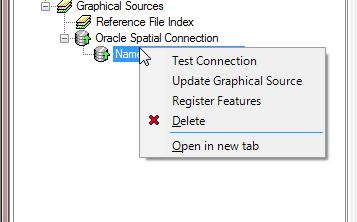
10 20, select sysdate from dual), mdsys.sdo_geometry 2001, null, mdsys.sdo_point_type100,200,null), null, null ), 0.785, 0.50, 0.50 ); commit; OPTIONAL CREATING A SEQUENCE GENERATOR In order for the spatial interface, in the Bentley products, to post new records to a particular spatial feature, a sequence generator must be created for the spatial feature. This is optional at the time of the creation of the spatial feature schema, in the database, because it can be done in the GSA when registering the feature. It is wise though to do this in the database, to keep the schema definition in one place the database). DROP SEQUENCE "point_feature_seq"; CREATE SEQUENCE "point_feature_seq" INCREMENT BY 1 START WITH 3 ORDER; commit; REGISTERING THE SPATIAL FEATURE WITH THE GSA Now that we have the spatial feature schema defined in the database, for the example feature, we need to setup the XFM schema through the GSA. The GSA is then used to generate all the feature interfaces, including the placement, viewing and editing of the feature instances. The GSA can also be used to setup the Bentley geospatial product workspaces, as an extension of the standard MicroStation workspaces. CREATE TEMPLATE XFM SCHEMA WITH ORACLE SPATIAL CONNECTION First we want to open the GSA and create a new schema. Then we want to navigate to the Graphical Sources and create a new Oracle Spatial Connection.


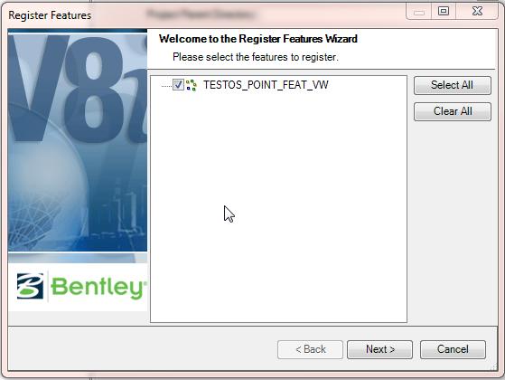
11 Now we want to register the features found in this spatial connection.
12


13 Finally we create a workspace, save the XFM schema file and Export the XFM schema and workspace, to be used in Bentley Map. TESTING FEATURE SETUP AND CONFIGURATION Now that we have the feature schema set up in the database, and have the XFM project set up and ready to use, we will start up Bentley Map with the XFM project and perform a few operatons, namely query, update, create and post features. First, let s open a work drawing, created from the GSA when setting up the XFM schema.


?")
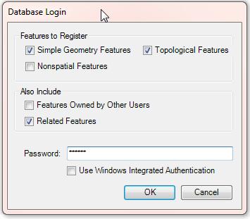
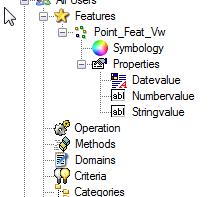
14 Notice that the 2 entries for placement and promote are listed in the Bentley Map command manager. This tells me that I have the XFM project loaded and ready to go. Now we want to go to the file pull down menu, and select the Open Oracle Spatial option. This will bring up the interoperability form. Select the Oracle node, and right mouse click to select the Open Graphical Source: testos item from the drop down list. Once you supply the password for the connection, and to the Oracle data source, you can now select a connection and the underlying features for manipulation. Make sure your spatial option is set for all for the connection and retrieve the features from the Point Feature class. Map will indicate how many of these features were queried from the spatial database, in our case it is the 2 inserts we did in the setup scripts. Let s use one of the standard Bentley Map tools to see what the non graphical data contains. As you can see, we have 4 properties from the business table, but where are the 4 properties we had from the spatial table geometry, rotation, x_scale, y_scale)? These properties are there, but are not maintained as business attributes, but rather are considered administrative attributes and are not available for the user to manipulate, at least thru forms, etc. that would edit the attributes. Now, the user can manipulate these thru graphical means, for instance moving the point feature, spatially, would update the geometry column of the spatial table. Also scaling or rotating the point feature would update the appropriate fields in the spatial table also.


15 If we change one of the attributes of the feature, we can then post this feature back to the database and review it s properties. This exercises the update trigger that we implemented on the view. We can also place a new feature in the drawing. Along with the graphics, we enter the business attributes during the placement operation. This functionality, besides placing a new feature, exercises the insert trigger of the view, when the new feature is posted to the database.


16 Once the feature is posted, we can look at the database, thru SQL Developer, and see the new row has been entered into the view. Once a feature has been posted, we can then lock the feature and delete it graphically. Once a post operation is performed, Bentley Map will inform the spatial database that a particular record has been deleted in the drawing, and to remove this row from the database. This operation exercises the delete trigger that we implemented on the view. FURTHER EXPANSIONS As you can see the use of views is a powerful tool in the consolidation of the spatial and business data domains. I just want to propose a few ideas for future topics, expanding upon the foundation laid in this entry. The use of views to maintain separate map products for a particular set of data. Regularly, especially in utilities industry, there is a need to produce maps at different scales, and different levels of detail. The use of views along with the XFM schema setups provide by the GSA, can be used to provide this level of integration. This is also important in providing white space management in different map outputs. The inclusion of other data sets into the spatial realm. This can be tabular data from other outside sources. Creation of other spatial features, without the recreation of the base data. Since the business and spatial data already exists, we can set up different views of the data with very little effort.
17
NRS Logical Data Model to Physical Data Model Transformations
 Corporate Services for the Natural Resource Sector Information Management Branch NRS Logical Data Model to Physical Data Model Transformations Last Updated: Dec 10 th, 2016 Version: 2.1 Document: NRS Logical
Hyperion Interactive Reporting Reports & Dashboards Essentials
 Oracle University Contact Us: +27 (0)11 319-4111 Hyperion Interactive Reporting 11.1.1 Reports & Dashboards Essentials Duration: 5 Days What you will learn The first part of this course focuses on two
Oracle Spatial Improving Quality of Data in New Zealand Post David Thornburrow
 Oracle Spatial Improving Quality of Data in New Zealand Post David Thornburrow New Zealand Post Introduction This paper is a real life example of how Oracle Spatial has made it possible for New Zealand
Introduction to Bentley Map
 Presenter: Chris Slavin, Project Manager, Professional Services Geospatial Bentley Systems, Incorporated 685 Stockton Drive Exton, PA 19341 www.bentley.com Lesson Name: Introduction to XFM...3 The Bentley
MicroStation. FDO Reader USER S MANUAL. [Företagets adress]
![MicroStation. FDO Reader USER S MANUAL. [Företagets adress]](/thumbs/93/111326866.jpg "MicroStation. FDO Reader USER S MANUAL. [Företagets adress]") MicroStation FDO Reader USER S MANUAL [Företagets adress] MicroStation FDO Reader - User s Manual, 2018-10-27 copyright, 2018 ringduvevägen 13, 132 47 saltsjö-boo e-mail: consulting@surell.se, web: www.surell.se
MicroStation FDO Reader USER S MANUAL [Företagets adress] MicroStation FDO Reader - User s Manual, 2018-10-27 copyright, 2018 ringduvevägen 13, 132 47 saltsjö-boo e-mail: consulting@surell.se, web: www.surell.se
Integrating ArcGIS to Enterprise Oracle Spatial Using Direct Connect
 Integrating ArcGIS to Enterprise Oracle Spatial Using Direct Connect Michael D. Tsengouras Principal Software Engineer Navigation Technologies Corporation Abstract: Many organizations are adopting Enterprise
GOOM Quick Reference Guide
 Using Oracle with GeoMedia Applications Chuck Woodbury Senior Consultant Technology Services Security, Government, and Infrastructure, a division of Intergraph Phone: 256-730-7755 E-mail: Chuck.Woodbury@intergraph.com
Get Oracle Schema Ddl Syntax With Dbms_metadata
 Get Oracle Schema Ddl Syntax With Dbms_metadata It there an easy way to extract DDLs from an Oracle 10 schema (tables and route, then rather than trying to convert Oracle DDL syntax to H2 you'd be better
Oracle BPEL Process Manager Demonstration
 January, 2007 1 Oracle BPEL Process Manager Demonstration How to create a time scheduler for a BPEL process using the Oracle Database Job scheduler by Dr. Constantine Steriadis (constantine.steriadis@oracle.com)
Using Jet Analytics with Microsoft Dynamics 365 for Finance and Operations
 Using Jet Analytics with Microsoft Dynamics 365 for Finance and Operations Table of Contents Overview...3 Installation...4 Data Entities...4 Import Data Entities...4 Publish Data Entities...6 Setting up
Registration of 3D Spatial Objects for 3D Cadastre
 Registration of 3D Spatial Objects for 3D Cadastre Mohd Hasif Ahmad Nasruddin and Alias Abdul Rahman Departments of Geoinformatics, Faculty of Geoinformation Science and Engineering, Universiti Teknologi
FME Extension for ArcGIS
 FME Extension for ArcGIS Welcome to the FME Extension for ArcGIS The FME Extension for ArcGIS uses Safe Software's FME technology. The FME Extension for ArcGIS allows users to integrate spatial data formats
User's Guide c-treeace SQL Explorer
 User's Guide c-treeace SQL Explorer Contents 1. c-treeace SQL Explorer... 4 1.1 Database Operations... 5 Add Existing Database... 6 Change Database... 7 Create User... 7 New Database... 8 Refresh... 8
MASTER-DETAIL FORMS. In this Chapter, you will learn about: Master-Detail Forms Page 108
 CHAPTER 4 MASTER-DETAIL FORMS CHAPTER OBJECTIVES In this Chapter, you will learn about: Master-Detail Forms Page 108 In the previous Chapters, you created and worked with forms that had only one base-table
Course Outline. Writing Reports with Report Builder and SSRS Level 1 Course 55123: 2 days Instructor Led. About this course
 About this course Writing Reports with Report Builder and SSRS Level 1 Course 55123: 2 days Instructor Led In this 2-day course, students will continue their learning on the foundations of report writing
A set of annotation templates that maybe used to label objects using information input in the data model mentioned above.
 AUTOCAD MAP 3D 2009 WHITE PAPER Industry Toolkits Introduction In today s world, passing of information between organizations is an integral part of many processes. With this comes complexity in a company
Using SQL with SQL Developer Part II
 One Data Manipulation in SQL Developer 2 Introduction 3 Updating a record in Data 4 Updating a Primary Key in Data 6 Reverting Changes using Refresh 7 Updating a table with a trigger in Data 8 Deleting
Feature Enhancements by Release
 Autodesk Map Feature Enhancements by Release This document highlights the feature enhancements that have occurred with each release of Autodesk Map software from Release 4 (2000i) through the current 2004
Key Terms. Attribute join Target table Join table Spatial join
 Key Terms Attribute join Target table Join table Spatial join Lect 10A Building Geodatabase Create a new file geodatabase Map x,y data Convert shape files to geodatabase feature classes Spatial Data Formats
Extended Element Properties. Contents
 Contents Introduction... 2 Installation and Configuration... 3 Geographic Coordinates... 4 Feature Types... 5 Usage... 8 Analyze XFM Feature... 8 Data Browser... 9 Map Interoperability... 10 Property Based
Real Application Security Administration
 Oracle Database Real Application Security Administration Console (RASADM) User s Guide 12c Release 2 (12.2) E85615-01 June 2017 Real Application Security Administration Oracle Database Real Application
AutoCAD Map 3D and ESRI ArcSDE
 AUTOCAD MAP 3D 2009 WHITE PAPER AutoCAD Map 3D and ESRI ArcSDE Many organizations, such as utilities, telecommunication providers, and government agencies, depend on geospatial data that is stored in a
Mike Horsfall Technical Manager GeoSpatial Sales
 An Introduction to Bentley Utilities Designer Mike Horsfall Technical Manager GeoSpatial Sales What is Bentley Utilities Designer? Bentley Utilities Designer is: A multi-utilities desktop GIS Built on
Oracle Hyperion Financial Management Instructor-led Live Online Training Program
 1. Introduction to Financial Management About Oracle's Enterprise Performance Management Suite Financial Management Solution Financial Consolidation, Reporting, Analysis and Product Components Financial
Connect Databases to AutoCAD with dbconnect Nate Bartley Test Development Engineer autodesk, inc.
 Connect Databases to AutoCAD with dbconnect Nate Bartley Test Development Engineer autodesk, inc. GD22-4 1 2 Agenda Introduction Overview of dbconnect Configure a data source Connect database to AutoCAD
Introduction to Geodatabase and Spatial Management in ArcGIS. Craig Gillgrass Esri
 Introduction to Geodatabase and Spatial Management in ArcGIS Craig Gillgrass Esri Session Path The Geodatabase - What is it? - Why use it? - What types are there? - What can I do with it? Query Layers
Using SQL with SQL Developer 18.1 Part II
 One Data Manipulation in SQL Developer 2 - Introduction 3 - Updating a record in Data 4 - Updating a Primary Key in Data 6 - Reverting Changes using Refresh 7 - Updating a table with a trigger in Data
Writing Reports with Report Designer and SSRS 2014 Level 1
 Writing Reports with Report Designer and SSRS 2014 Level 1 Duration- 2days About this course In this 2-day course, students are introduced to the foundations of report writing with Microsoft SQL Server
Sql Server Check If Global Temporary Table Exists
 Sql Server Check If Global Temporary Table Exists I am trying to create a temp table from the a select statement so that I can get the schema information from the temp I have yet to see a valid justification
PLAY VIDEO. Fences can be any shape from a simple rectangle to a multisided polygon, even a circle.
 Chapter Eight Groups PLAY VIDEO INTRODUCTION There will be times when you need to perform the same operation on several elements. Although this can be done by repeating the operation for each individual
Utility Network Management in ArcGIS: Migrating Your Data to the Utility Network. John Alsup & John Long
 Utility Network Management in ArcGIS: Migrating Your Data to the Utility Network John Alsup & John Long Presentation Outline Utility Network Preparation - Migration Patterns - Understanding the Asset Package
MySQL for Beginners Ed 3
 MySQL for Beginners Ed 3 Duration: 4 Days What you will learn The MySQL for Beginners course helps you learn about the world's most popular open source database. Expert Oracle University instructors will
MySQL for Developers with Developer Techniques Accelerated
 Oracle University Contact Us: 02 696 8000 MySQL for Developers with Developer Techniques Accelerated Duration: 5 Days What you will learn This MySQL for Developers with Developer Techniques Accelerated
Day 1 Agenda. Brio 101 Training. Course Presentation and Reference Material
 Data Warehouse www.rpi.edu/datawarehouse Brio 101 Training Course Presentation and Reference Material Day 1 Agenda Training Overview Data Warehouse and Business Intelligence Basics The Brio Environment
PLAY VIDEO. 2. Select Cell Library File menu > New item to display the Create Cell Library dialog.
 Chapter 12 Cells PLAY VIDEO INTRODUCTION A cell is a group of elements combined into one complex element and stored in a cell library or in your design file as a shared cell. Any cell can be easily recalled
Exercise 1: Introduction to MapInfo
 Geog 578 Exercise 1: Introduction to MapInfo Page: 1/22 Geog 578: GIS Applications Exercise 1: Introduction to MapInfo Assigned on January 25 th, 2006 Due on February 1 st, 2006 Total Points: 10 0. Convention
Sage 300 ERP Intelligence Reporting Connector Advanced Customized Report Writing
 Sage 300 ERP Intelligence Reporting Connector Advanced Customized Report Writing Sage Intelligence Connector Welcome Notice This document and the Sage software may be used only in accordance with the accompanying
VDOT Creating Plats with GEOPAK 2004 Edition (Version 8.8)
") VDOT Creating Plats with GEOPAK 2004 Edition (Version 8.8) TRN013000-1/0001 Copyright Information Trademarks Patents Copyrights AccuDraw, Bentley, the B Bentley logo, MDL, MicroStation and SmartLine are
VDOT Creating Plats with GEOPAK 2004 Edition (Version 8.8) TRN013000-1/0001 Copyright Information Trademarks Patents Copyrights AccuDraw, Bentley, the B Bentley logo, MDL, MicroStation and SmartLine are
Accessing and Administering your Enterprise Geodatabase through SQL and Python
 Accessing and Administering your Enterprise Geodatabase through SQL and Python Brent Pierce @brent_pierce Russell Brennan @russellbrennan hashtag: #sqlpy Assumptions Basic knowledge of SQL, Python and
Basic Tasks in ArcGIS 10.3.x
 Basic Tasks in ArcGIS 10.3.x This guide provides instructions for performing a few basic tasks in ArcGIS 10.3.1, such as adding data to a map document, viewing and changing coordinate system information,
Integrating CAD Data with ArcGIS
 Integrating CAD Data with ArcGIS Agenda An Overview of CAD Drawings CAD Data Structure in ArcGIS Visualization Georeferencing Data Conversion ArcGIS for AutoCAD Q & A CAD Drawings - Overview Widely used
Chapter 7. Introduction to Structured Query Language (SQL) Database Systems: Design, Implementation, and Management, Seventh Edition, Rob and Coronel
 Database Systems: Design, Implementation, and Management, Seventh Edition, Rob and Coronel") Chapter 7 Introduction to Structured Query Language (SQL) Database Systems: Design, Implementation, and Management, Seventh Edition, Rob and Coronel 1 In this chapter, you will learn: The basic commands
Chapter 7 Introduction to Structured Query Language (SQL) Database Systems: Design, Implementation, and Management, Seventh Edition, Rob and Coronel 1 In this chapter, you will learn: The basic commands
March 2007 Oracle Spatial User Conference
 March 8, 2007 Henry B. Gonzalez Convention Center San Antonio, Texas USA Keath Long Senior GIS Analyst Matt Seidl CAD Analyst Oracle Spatial: Narrowing the Gap Between CAD and GIS: A Topobase Implementation
T-SQL Training: T-SQL for SQL Server for Developers
 Duration: 3 days T-SQL Training Overview T-SQL for SQL Server for Developers training teaches developers all the Transact-SQL skills they need to develop queries and views, and manipulate data in a SQL
Additional Spatial Analysis Functions
 APPENDIX A Additional Spatial Analysis Functions In Chapters 8 and 9 we described how to perform proximity analysis using the SDO_GEOMETRY data in Oracle tables. We described a variety of functions and
Oracle Spatial Pure Web Editing for Telco Outside Plant Engineering Planning. Eamon Walsh espatial Solutions
 Spatial SIG Oracle Spatial Pure Web Editing for Telco Outside Plant Engineering Planning Eamon Walsh espatial Solutions Speaker Eamon Walsh, CTO espatial Solutions. over 20 years experience in the IT industry,
Oracle Database 10g Express
 Oracle Database 10g Express This tutorial prepares the Oracle Database 10g Express Edition Developer to perform common development and administrative tasks of Oracle Database 10g Express Edition. Objectives
GIS Basics for Urban Studies
 GIS Basics for Urban Studies Date: March 21, 2018 Contacts: Mehdi Aminipouri, Graduate Peer GIS Faciliator, SFU Library (maminipo@sfu.ca) Keshav Mukunda, GIS & Map Librarian Librarian for Geography (kmukunda@sfu.ca)
Oracle Database: Introduction to SQL/PLSQL Accelerated
 Oracle University Contact Us: Landline: +91 80 67863899 Toll Free: 0008004401672 Oracle Database: Introduction to SQL/PLSQL Accelerated Duration: 5 Days What you will learn This Introduction to SQL/PLSQL
Oracle Database. Installation and Configuration of Real Application Security Administration (RASADM) Prerequisites
 Prerequisites") Oracle Database Real Application Security Administration 12c Release 1 (12.1) E61899-04 May 2015 Oracle Database Real Application Security Administration (RASADM) lets you create Real Application Security
Oracle Database Real Application Security Administration 12c Release 1 (12.1) E61899-04 May 2015 Oracle Database Real Application Security Administration (RASADM) lets you create Real Application Security
MySQL for Developers Ed 3
 Oracle University Contact Us: 1.800.529.0165 MySQL for Developers Ed 3 Duration: 5 Days What you will learn This MySQL for Developers training teaches developers how to plan, design and implement applications
Introduction to the Dimensionally Extended 9 Intersection Model (DE-9IM) in PostgreSQL/PostGIS Tutorial
 in PostgreSQL/PostGIS Tutorial") Introduction to the Dimensionally Extended 9 Intersection Model (DE-9IM) in PostgreSQL/PostGIS Tutorial Germán Carrillo gcarrillo@uni-muenster.de geotux_tuxman@linuxmail.org Objectives Following this tutorial
Introduction to the Dimensionally Extended 9 Intersection Model (DE-9IM) in PostgreSQL/PostGIS Tutorial Germán Carrillo gcarrillo@uni-muenster.de geotux_tuxman@linuxmail.org Objectives Following this tutorial
ARIS Admintool Commands
 Appendix A ARIS Admintool Commands Command Backup Backupconfig Configadminpassword Copy Createdb Dbmspassword Delete Download Exit Help Syntax / Description backup all []
Chapter 1 SQL and Data
 Chapter 1 SQL and Data What is SQL? Structured Query Language An industry-standard language used to access & manipulate data stored in a relational database E. F. Codd, 1970 s IBM 2 What is Oracle? A relational
Oracle Spatial Users Conference
 April 2006 April 27, 2006 Tampa Convention Center Tampa, Florida, USA April 2006 Michael Smith Physical Scientist Remote Sensing/GIS Center of Expertise Army Corps of Engineers Engineer Research & Development
Bentley Map Geospatial Administrator Workspace Base Source Directory and Files Node
 Bentley Map Geospatial Administrator Workspace Base Source Directory and Files Node The Geospatial Administrator provides expected flexibility to define and customize your Bentley Map projects. This includes
ORACLE DATABASE 12C INTRODUCTION
 SECTOR / IT NON-TECHNICAL & CERTIFIED TRAINING COURSE In this training course, you gain the skills to unleash the power and flexibility of Oracle Database 12c, while gaining a solid foundation of database
Step by Step GIS. Section 1
 Step by Step GIS Section 1 Contact the web page given below for the data required to do the exercises (http://www.pasda.psu.edu/default.asp) Before beginning the tutorials please visit the Preparation
Using the IMS Universal Drivers and QMF to Access Your IMS Data Hands-on Lab
 Using the IMS Universal Drivers and QMF to Access Your IMS Data Hands-on Lab 1 Overview QMF for Workstation is an Eclipse-based, rich client desktop Java application, that uses JDBC to connect to data
Importing source database objects from a database
 Importing source database objects from a database We are now at the point where we can finally import our source database objects, source database objects. We ll walk through the process of importing from
WHAT IS A DATABASE? There are at least six commonly known database types: flat, hierarchical, network, relational, dimensional, and object.
 1 WHAT IS A DATABASE? A database is any organized collection of data that fulfills some purpose. As weather researchers, you will often have to access and evaluate large amounts of weather data, and this
Name: Date: June 27th, 2011 GIS Boot Camps For Educators Lecture_3
 Name: Date: June 27th, 2011 GIS Boot Camps For Educators Lecture_3 Practical: Creating and Editing Shapefiles Using Straight, AutoComplete and Cut Polygon Tools Use ArcCatalog to copy data files from:
SQL functions fit into two broad categories: Data definition language Data manipulation language
 Database Principles: Fundamentals of Design, Implementation, and Management Tenth Edition Chapter 7 Beginning Structured Query Language (SQL) MDM NUR RAZIA BINTI MOHD SURADI 019-3932846 razia@unisel.edu.my
IMAGINE Enterprise Editor
 IMAGINE Enterprise Editor User s Guide August 5, 2006 Copyright 2006 Leica Geosystems Geospatial Imaging, LLC All rights reserved. Printed in the United States of America. The information contained in
Rubis (NUM) Tutorial #1
 Tutorial #1") Rubis (NUM) Tutorial #1 1. Introduction This example is an introduction to the basic features of Rubis. The exercise is by no means intended to reproduce a realistic scenario. It is assumed that the user
Rubis (NUM) Tutorial #1 1. Introduction This example is an introduction to the basic features of Rubis. The exercise is by no means intended to reproduce a realistic scenario. It is assumed that the user
6 Cells. When you have completed this chapter, you will be able to:
 6 Cells Designs are often repetitive, we may use the same group of elements many times over. For example, we may need to place a thousand identical seats in a theatre, each seat comprised of a number of
Moving Dynamic Segmentation to the Server: Linear Referencing for Web- Based Applications
 Moving Dynamic Segmentation to the Server: Linear Referencing for Web- Based Applications Paper 6.4.2 Graham Stickler and Rob Coupe Exor Corporation Contents Why move things to the database Oracle spatial
Introduction to SQL/PLSQL Accelerated Ed 2
 Oracle University Contact Us: Local: 1800 103 4775 Intl: +91 80 67863102 Introduction to SQL/PLSQL Accelerated Ed 2 Duration: 5 Days What you will learn This Introduction to SQL/PLSQL Accelerated course
GIS Exercise 10 March 30, 2018 The USGS NCGMP09v11 tools
 GIS Exercise 10 March 30, 2018 The USGS NCGMP09v11 tools As a result of the collaboration between ESRI (the manufacturer of ArcGIS) and USGS, ESRI released its Geologic Mapping Template (GMT) in 2009 which
SQL IN PL/SQL. In this chapter, you will learn about: Making Use of DML in PL/SQL Page 68 Making Use of Savepoint Page 77
 CHAPTER 4 SQL IN PL/SQL CHAPTER OBJECTIVES In this chapter, you will learn about: Making Use of DML in PL/SQL Page 68 Making Use of Savepoint Page 77 This chapter is a collection of some fundamental elements
Oracle SQL. murach s. and PL/SQL TRAINING & REFERENCE. (Chapter 2)
") TRAINING & REFERENCE murach s Oracle SQL and PL/SQL (Chapter 2) works with all versions through 11g Thanks for reviewing this chapter from Murach s Oracle SQL and PL/SQL. To see the expanded table of contents
TRAINING & REFERENCE murach s Oracle SQL and PL/SQL (Chapter 2) works with all versions through 11g Thanks for reviewing this chapter from Murach s Oracle SQL and PL/SQL. To see the expanded table of contents
CSC Web Programming. Introduction to SQL
 CSC 242 - Web Programming Introduction to SQL SQL Statements Data Definition Language CREATE ALTER DROP Data Manipulation Language INSERT UPDATE DELETE Data Query Language SELECT SQL statements end with
Oracle. Oracle Spatial 11g Essentials. 1z Version: Demo. [ Total Questions: 10] Web:
![Oracle. Oracle Spatial 11g Essentials. 1z Version: Demo. [ Total Questions: 10] Web:](/thumbs/90/101573895.jpg "Oracle. Oracle Spatial 11g Essentials. 1z Version: Demo. [ Total Questions: 10] Web:") Oracle 1z0-595 Oracle Spatial 11g Essentials Version: Demo [ Total Questions: 10] Web: www.myexamcollection.com Email: support@myexamcollection.com IMPORTANT NOTICE Feedback We have developed quality product
Oracle 1z0-595 Oracle Spatial 11g Essentials Version: Demo [ Total Questions: 10] Web: www.myexamcollection.com Email: support@myexamcollection.com IMPORTANT NOTICE Feedback We have developed quality product
Database Systems: Design, Implementation, and Management Tenth Edition. Chapter 7 Introduction to Structured Query Language (SQL)
") Database Systems: Design, Implementation, and Management Tenth Edition Chapter 7 Introduction to Structured Query Language (SQL) Objectives In this chapter, students will learn: The basic commands and
Database Systems: Design, Implementation, and Management Tenth Edition Chapter 7 Introduction to Structured Query Language (SQL) Objectives In this chapter, students will learn: The basic commands and
Oracle Spatial. Quadtree Indexing 10g Release 1 (10.1)
") Oracle Spatial Quadtree Indexing 10g Release 1 (10.1) Part No. B12157-01 December 2003 Provides usage and reference information for the deprecated quadtree indexing capabilities of Oracle Spatial and Oracle
Oracle Spatial Quadtree Indexing 10g Release 1 (10.1) Part No. B12157-01 December 2003 Provides usage and reference information for the deprecated quadtree indexing capabilities of Oracle Spatial and Oracle
TRAINING GUIDE. Data Quality Tools for GIS and Lucity Spatial
 TRAINING GUIDE Data Quality Tools for GIS and Lucity Spatial Data Quality Tools for GIS and Lucity Spatial In this session, we ll cover the tools that can be used to ensure your GIS data is clean in regards
Why use an RDBMS? ❽ Data maintenance ❽ Standardized access ❽ Multi-user access ❽ Data protection
 1 Why use an RDBMS? ❽ Data maintenance ❽ Standardized access ❽ Multi-user access ❽ Data protection 2 RDBMSs offer Data protection ❽ Recovery ❽ Concurrency ❽ Security 3 Data protection ❽ Recovery from ❽
Using the IMS Universal Drivers and QMF to Access Your IMS Data Hands-on Lab
 Attendee Choice: IMS Hands-on Lab Thursday, August 13, 2015: 12:30 PM - 01:30 PM, Dolphin, Asia 5 #17765 Insert Custom Session QR if Desired Business Analytics on zenterprise The QMF 11 Product Family
MySQL Database Administrator Training NIIT, Gurgaon India 31 August-10 September 2015
 MySQL Database Administrator Training Day 1: AGENDA Introduction to MySQL MySQL Overview MySQL Database Server Editions MySQL Products MySQL Services and Support MySQL Resources Example Databases MySQL
BW C SILWOOD TECHNOLOGY LTD. Safyr Metadata Discovery Software. Safyr User Guide
 BW C SILWOOD TECHNOLOGY LTD Safyr Metadata Discovery Software Safyr User Guide S I L W O O D T E C H N O L O G Y L I M I T E D Safyr User Guide Safyr 7.1 This product is subject to the license agreement
Get Table Schema In Sql Server 2008 To Add Column If Not Exists >>>CLICK HERE<<<
 Get Table Schema In Sql Server 2008 To Add Column If Not Exists IF NOT EXISTS ( SELECT * FROM sys.columns WHERE object_id = OBJECT_ID(N'(dbo). Also try catch is easily possible to use in sql serverand
Oracle Database 10g: Introduction to SQL
 ORACLE UNIVERSITY CONTACT US: 00 9714 390 9000 Oracle Database 10g: Introduction to SQL Duration: 5 Days What you will learn This course offers students an introduction to Oracle Database 10g database
Welcome to MicroStation
 Welcome to MicroStation Module Overview This module will help a new user become familiar with the tools and features found in the MicroStation design environment. Module Prerequisites Fundamental knowledge
Workbooks (File) and Worksheet Handling
 and Worksheet Handling") Workbooks (File) and Worksheet Handling Excel Limitation Excel shortcut use and benefits Excel setting and custom list creation Excel Template and File location system Advanced Paste Special Calculation
Workbooks (File) and Worksheet Handling Excel Limitation Excel shortcut use and benefits Excel setting and custom list creation Excel Template and File location system Advanced Paste Special Calculation
Kelar Corporation. Leaseline Management Application (LMA)
") Kelar Corporation Leaseline Management Application (LMA) Overview LMA is an ObjectARX application for AutoCAD Map software. It is designed to add intelligence to the space management drawings associated
Kelar Corporation Leaseline Management Application (LMA) Overview LMA is an ObjectARX application for AutoCAD Map software. It is designed to add intelligence to the space management drawings associated
Exercise 1: An Overview of ArcMap and ArcCatalog
 Exercise 1: An Overview of ArcMap and ArcCatalog Introduction: ArcGIS is an integrated collection of GIS software products for building a complete GIS. ArcGIS enables users to deploy GIS functionality
Data Interoperability Extension Tutorial
 Data Interoperability Extension Tutorial Copyright 1995-2012 Esri All rights reserved. Table of Contents About the Data Interoperability extension tutorial...................... 3 Exercise 1: Using direct-read
JUNE 2016 PRIMAVERA P6 8x, CONTRACT MANAGEMENT 14x AND UNIFIER 16x CREATING DASHBOARD REPORTS IN ORACLE BI PUBLISHER
 JUNE 2016 PRIMAVERA P6 8x, CONTRACT MANAGEMENT 14x AND UNIFIER 16x ABSTRACT An often requested feature in reporting is the development of simple Dashboard reports that summarize project information in
Introduction to GIS & Mapping: ArcGIS Desktop
 Introduction to GIS & Mapping: ArcGIS Desktop Your task in this exercise is to determine the best place to build a mixed use facility in Hudson County, NJ. In order to revitalize the community and take
MySQL for Developers Ed 3
 Oracle University Contact Us: 0845 777 7711 MySQL for Developers Ed 3 Duration: 5 Days What you will learn This MySQL for Developers training teaches developers how to plan, design and implement applications
Final Project: Integrating ArcGIS Server with Google Maps Creating a Southern California Wildfire Mapping Application
 Final Project: Integrating ArcGIS Server with Google Maps Creating a Southern California Wildfire Mapping Application In the final project for this course you will be creating an integrated Google Maps
Oracle Spatial Best Practices and Tuning Tips for DBAs and Developers
 Oracle Spatial Best Practices and Tuning Tips for DBAs and Developers Daniel Geringer Senior Software Development Manager Oracle s Spatial Technologies Spatial Data Validation VALIDATE_GEOMETRY_WITH_CONTEXT
Oracle Utilities Work and Asset Management
 Oracle GIS Viewer Oracle Utilities Work and Asset Management Oracle GIS Viewer Installation and Configuration Guide Release 1.9.1.2.5 July 2015 Oracle Utilities Work and Asset Management Oracle GIS Viewer
Basic Queries Exercise - Haiti
 Basic Queries Exercise - Haiti Written by Barbara Parmenter, revised by Carolyn Talmadge on September 18, 2016 SETTING UP... 1 WHERE ARE THE HOSPITALS THAT ARE STILL OPERATING? (SELECT BY ATTRIBUTE )...
Using ESRI data in Autodesk ISD Products
 GI13-3 Using ESRI data in Autodesk ISD Products 1.5 hr. Class 02-Dec-03 3:30pm - 5:00pm Session Description: We will focus on using data in a variety of ESRI formats within the Autodesk GIS product line,
Bentley Plant Workshop
 Bentley Plant Workshop 2013 Bentley LEARNing Conference PLOP2WK1 OpenPlant 2D/3D Interoperability Team Leader: Tony DeRosa Team Members: Brian Earles Bentley Systems, Incorporated 685 Stockton Drive Exton,
Chapter # 7 Introduction to Structured Query Language (SQL) Part I
 Part I") Chapter # 7 Introduction to Structured Query Language (SQL) Part I Introduction to SQL SQL functions fit into two broad categories: Data definition language Data manipulation language Basic command set
Chapter # 7 Introduction to Structured Query Language (SQL) Part I Introduction to SQL SQL functions fit into two broad categories: Data definition language Data manipulation language Basic command set
IBM WebSphere Adapter for Oracle E-Business Suite Quick Start Tutorials
 IBM WebSphere Adapter for Oracle E-Business Suite 7.0.0.0 Quick Start Tutorials Note: Before using this information and the product it supports, read the information in the "Notices" section, at the end
IBM. Database Database overview. IBM i 7.1
 IBM IBM i Database Database overview 7.1 IBM IBM i Database Database overview 7.1 Note Before using this information and the product it supports, read the information in Notices, on page 39. This edition
Oracle Database 10g. Empowering Applications with Spatial Analysis and Mining. An Oracle Technical White Paper February 2004
 Oracle Database 10g Empowering Applications with Spatial Analysis and Mining An Oracle Technical White Paper February 2004 TABLE OF CONTENTS 1 INTRODUCTION...1 2 SPATIAL ANALYSIS IN ORACLE 10G: FUNCTIONALITY