The GIGAS Methodology
|
|
|
- Frederick Dickerson
- 5 years ago
- Views:
Transcription
1 The GIGAS Methodology Pier Giorgio Marchetti European Space Agency Earth Observation Programme Ground Segment Department
2 GIGAS Objectives GIGAS has the goal to promote the coherent and interoperable development of the GMES, INSPIRE and GEOSS initiatives through their concerted adoption of standards, protocols, and open architectures by Analysing the gaps between the different initiatives and proposing strategies to overcome them Highlighting best-practice examples from finished FP6 or ongoing FP7 projects relevant for the identified gaps Initiating a consensus process on a broad basis for public consultation and consensus building Shaping the initiatives by providing short term action items Influencing the relevant standardisation bodies to ensure the long-term action Providing an agenda for further strategic research areas to ensure investigation on the problems that are unsolved today
3 GIGAS Methodology GIGAS has developed a detailed methodology to document architecture, process and consensus mechanisms for each initiative This methodology has been used as the basis for examining requirements, architectures and standards applied on the systems in order to provide an evaluation of them in terms of business, enterprise, information and engineering and technology architecture, as well as their strategic alignment The purpose of GIGAS is not to make studies within each initiative, this is already in the scope of the initiatives and any information can be found inside the initiative documents GIGAS is expected to make a cross-initiative study, each feature or architectural aspect is analysed not only on a single initiative but across the three initiatives.
4 Issues and Objectives Make analysis GIGAS Methodology simple and affordable with a limited amount of resources involve participation from different actors: managers, architects, engineers, scientists Deals with systems of systems Built independently from each other Long running programmes with independent schedules Typical questions Where establish synergy? If and what to merge? How to build interfaces?
5 GIGAS Approach The approach proposed by GIGAS is based on three steps: Technology watch i.e. draw a picture of the current situation Comparative analysis i.e. identify areas with commonalities and/or gaps for interoperability Shaping of initiatives and standards i.e. provide recommendations to initiatives or standardisation bodies or entities The above steps will be repeated twice (in two loops) during GIGAS lifetime but can be repeated multiple times after the project conclusion if a persisting infrastructure is established This presentation concentrates on the methodology for technology watch, and comparative analysis
6 GIGAS Approach Technology watch Comparative analysis
7 Technology Watch Objectives Define a common framework to be used for a homogeneous description of all the GIGAS initiatives, projects and standards in terms of User and system requirements Architecture Data Services Standards Use a simple and reusable solution Minimise the effort
8 Technology Watch Solution An RM-ODP-based approach (ISO/IEC 10746) has been selected as a framework for GIGAS Technology Watch as: most of the systems to be compared are based on RM-ODP it supports aspects of distributed processing it aims at fostering interoperability across heterogeneous systems, it tries to hide as much as possible consequences of distribution to systems developers The RM-ODP concepts are tailored for the GIGAS needs as: most of the systems to be considered have the characteristic of a loosely-coupled network of systems and services instead of a distributed processing system based on interacting objects
9 GIGAS Methodology: RM-ODP The RM-ODP defines 5 standard viewpoints Enterprise viewpoint: A viewpoint on the system and its environment that focuses on the purpose, scope and policies for the system Information viewpoint: A viewpoint on the system and its environment that focuses on the semantics of the information and information processing performed Computational/service viewpoint: A viewpoint on the system and its environment that enables distribution through functional decomposition of the system into objects which interact at interfaces Engineering viewpoint: A viewpoint on the system and its environment that focuses on the mechanisms and functions required to support distributed interaction between objects in the system Technology viewpoint: A viewpoint on the system and its environment that focuses on the choice of technology in that system
10 GIGAS Methodology: RM-ODP Specific templates have been created for each viewpoint based on the RM-ODP definitions All the different initiatives, projects, standards have been described using the same templates allowing a uniform modeling and a simple comparison Same methodology for a two level study System Architecture Individual features/topics (e.g. catalogue, WMS, ordering..)
11 GIGAS Methodology: Enterprise Viewpoint Enterprise Viewpoint Template Summary table with project/initiative general features High Level Requirements Context/Use Cases
12 GIGAS Methodology: Enterprise Viewpoint Summary Table Aspect Context Start and End Date Description The Heterogeneous Missions Accessibility (HMA) analyses the requirements, and proposes an approach to allow the desired inter-accessibility across missions forming part of GMES. The initial preparatory study HMA-I (HMA Interoperability) started in September 2005 and ended in October The CDS EO-DAIL should be operational by 2009 and be available for the GMES FTS services. Home Page Summary Reference to architecture specification Source of Requirements Business rules (model), The objective of the HMA-I Preparatory study was to define a harmonised access to heterogeneous EO missions data from multiple missions G/S s, including national missions and ESA Sentinel missions through an access point called EO-DAIL. In the initial phase, high-level requirements and operational scenarios were gathered from ESA, the project partners and the consortium, and a set of consolidated scenarios were produced. The specifications of the architecture and services were then derived from these scenarios and a subset of the requirements was selected for validation by prototyping. In the following phase, the specifications were used to produce the architecture design of the EO DAIL and the ICD s to a selected set of services. These ICD s were then submitted to a standards body for acceptance, giving them an international legitimacy. GMES HMA Architectural Design Technical Note [RD-HMA-5] EADS-Astrium UK and ESA were supported by the contributions of the already identified project partners who have a direct contractual relationship with ESA in HMA : The CDS is providing the interoperability framework and architecture for the operational provision of data accessfrom the national and Eumetsat missions contributing during GMES Space Component Phase 1 to provide the necessary data for the GMES Services.
13 GIGAS Methodology: Enterprise Viewpoint Security rules Authority rules for privileges and permissions Resource usage rules Transfer rules, Domain rules Important use cases Access control mechanisms embedded in architecture, specification and implementation. See also Technology Watch for CDS User Management. none pilot-specific public specifications, re-use of software components depending on partner Closed consortium; advisory board with selected users The CDS and the DAIL in particular focus on the definition of following interfaces: Collection and Service Discovery service,. Catalogue service, t; Ordering service, to order products identified in a catalogue; Programming Service, to place request for new acquisitions; Online Data Access Services, to retrieve products from the online access archives offered through the HMA; User Management Services, to manage all information related to a user and access to the services. Detailed scenarios and use cases for the CDS and EO DAIL were established as part of the HMA-I Preparatory Study. The scenarios can be found in HMA Scenario Technical Note [RD-HMA-10]. Table 62: Enterprise Viewpoint of the GMES CDS EO-DAIL
14 GIGAS Methodology: Enterprise Viewpoint High Level Requirements The following high level requirements guide the architectural choices of the CDS customer interface and the interaction with the GSC Contributing Missions (GCMs) (source: ESA HMA Software Requirements Review presentation March 2006): CDS-CI-GEN-001: The GMES ground segment shall provide the necessary interfaces for requesting and accessing data from national and Eumetsat missions forming part of GMES. Note: The component publishing these interfaces is named Customer Interface of the Coordinated Data Access System (CDS) a.k.a. Data Access Integration Layer DAIL. CDS-CI-GEN-002: The architecture shall permit to integrate EO products, space data with all kinds of other data and information. CDS-CI-GEN-003: The architecture shall be able to support the GMES Data Policy, which will be defined at a later stage. CDS-CI-GEN-003: The architecture shall make no restrictions about user groups, user privileges or data pricing. CDS-CI-GEN-004: The overall architecture shall be driven to minimise the cost and impact on GMES Contributing Missions ground segments. CDS-CI-GEN-005: The architecture shall be independent of a particular GMES Contributing Mission ground segment. CDS-CI-GEN-006: The architecture shall permit its adoption by additional missions in the future.
15 GIGAS Methodology: Enterprise Viewpoint Context This harmonised access is offered through the Coordinated Data access System (CDS) depicted in the figure below. The CDS is limited to providing access to the EO products. Figure 1:- GMES Space Component Data Access Overview
16 GIGAS Methodology: Enterprise Viewpoint Use Case
17 GIGAS Methodology: Information Viewpoint Information Viewpoint Template Set of tables describing data, metadata and data models of each project/initiative
18 GIGAS Methodology: Information Viewpoint CDS EO-DAIL Information Viewpoint Aspect Model name Category Description Service and Collection Metadata Model Reference to specification Standard reference Description Format Comment ISO [RD-HMA-11] ISO [RD-HMA-12] ISO [RD-HMA-13] OASIS UDDI [RD-HMA-14] ISO defines the model for geographic services metadata, it however does not cater for the XML encodings of these. This is dealt with in the ISO specification that describes the transformation of the abstract UML models into XML schema. ISO standards also is used for the XML encoding of EO Collection metadata, another important category of information within our architecture. EO collections are described in accordance with the ISO model for geographic metadata. UML, XML ISO [RD-HMA-13] Table 63: CDS Service and Collection Metadata Model
19 GIGAS Methodology: Information Viewpoint Aspect Model name Category Description EO Product Metadata Model Basic model Reference to specification Standard reference GML (ISO 19136) [RD-HMA-15] OGC [RD-HMA-16] Description However the most important information model is the one of the EO Product metadata which has been based on OGC s GML (Geography Mark-Up Language) and where the modularity vis-à-vis the different types of missions or sensors has been achieved by defining different application schemas for optical (OPT), radar (SAR) and atmospheric (ATM) that are extending the underlying schemas as described in the following figure. Specific, tight community Other Specific Mission EO Products description Other Thematic EO Products description Mission Specific EO Products Viewer PHR Thematic EO Products Viewer OPT SAR ATM General EO Products Viewer EOP Generic GML Viewer GML Generic, widespread community Figure 1:- Layered EO Product Metadata. Format UML, XML GML (ISO 19136) [RD-HMA-15] OGC [RD-HMA-16] Comment
20 GIGAS Methodology: Service Viewpoint Service Viewpoint Template Summary table with the list of services each project/initiative Set of tables describing each service of each project/initiative
21 GIGAS Methodology: Service Viewpoint Aspect Service metamodel Description ISO 19119:2005: The OpenGIS Abstract Specification; Topic 12: OpenGIS Service Architecture Service Taxonomy GMES HMA services can be classified according to different perspectives: Human interaction services Model/Information management services Workflow/Task management services Processing services Communication services System management services Table 68: GMES CDS EO-DAIL Service meta-model and taxonomy
22 GIGAS Methodology: Service Viewpoint Aspect Service name Category Reference to specification Standard reference Description Catalogue Model/Information management service Dataset metadata: ISO [RD-HMA-11] OGC GML (Geography Markup Language) [RD-HMA-15] OGC GML Application Schema for EO Products [RD-HMA-16] OGC : Catalogue [RD-HMA-17] OGC : ebrim Application Profile for CSW [RD-HMA-18] OGC Extension Package for ebrim Application Profile of CSW [RD-HMA- 21] OGC : User Management Interfaces for Earth Observation Services [RD-HMA-20] Description Format Comment This service interface enables GMES Service Projects to discover and retrieve metadata about available Earth Observation (EO) datasets. The returned dataset metadata and queryables map to the GML Application Schema for EO (OGC ) metadata. The interface is extensible for various types of EO data. The current specification covers optical, radar and atmospheric missions as explained in the Information Viewpoint above. WSDL Table 70: GMES CDS EODAIL Catalogue Service
23 GIGAS Methodology: Engineering Viewpoint Engineering Viewpoint Template Scenarios expanding use cases Definition of policies (e.g. access control) Engineering Viewpoint is less significant from a GIGAS perspective
24 GIGAS Methodology: Technology Viewpoint Technology Viewpoint Template Platforms Runtime Environment Standardisation Process Technology Viewpoint is less significant from a GIGAS perspective
25 GIGAS Approach Technology watch Comparative analysis
26 GIGAS Comparative Analysis Based on the outcomes of the previous Technology Watch, GIGAS undertakes a comparative analysis on used by solutions, requirements, architecture, models, processes consensus mechanisms INSPIRE, GMES and GEOSS, taking into account the monitoring of FP6/FP7 research projects the ongoing standardization activities searching for gaps and commonalities with the goal of interoperability
27 GIGAS Comparative Analysis
28 GIGAS Comparative Analysis The result of the Comparative Analysis includes: A technical note summarising the results of the study The identification of technological gaps to be explored in the following shaping phase Guidelines and objectives for the architectural approach within GIGAS A set of draft recommendations (mainly) to GEOSS, INSPIRE and GMES to be expanded and processed in depth in the following shaping phase Analysis on the schedules of the three initiatives and on the FP6/FP7 programs and standardization activities, with identification of key milestones or intervention points
29 GIGAS Comparative Analysis The draft recommendations are the main result of the comparative analysis are derived from a critical analysis of the technology watch reports are extracted, processed and refined on the basis of a set of criteria used to identify priorities: Cost-benefit trade-off for interoperability Governance Schedule Previous feedbacks from the initiatives Long term perspective and global scenario
30 GIGAS Draft Recommendations: Types Revising existing specifications/standards Testing Further investigation about the subject Communication Submission for consideration as reference material Funding Research Governance/Political
31 GIGAS Draft Recommendations: Addressed Entities Initiatives INSPIRE GEOSS GMES (either GSC, FTS or both) SEIS Standardisation Bodies ISO CEN OGC GIGAS Consortium
32 GIGAS Draft Recommendations: Syntax REC-[topic-acronym]-[counter] [title of the recommendation] It is recommended To [entity] [text of the recommendation] Rationale: [if any, text of the rationale] Dependencies : [if any, text of the dependencies]
33 GIGAS Draft Recommendations: Samples REC-CAT-001 Cross-initiative scenario It is recommended to: the INSPIRE, GEOSS and GMES stakeholders that they set up a cross-initiative scenario dealing with resource discovery in the context of climate change, with cadastral data obtained from INSPIRE and Earth Observation data obtained from GMES and GEOSS Rationale: One of the difficulties of identifying potential interoperability issues between the three initiatives is the lack of known requirements with regard to cross-initiative real-world interactions. Such a scenario would help create a concrete context for the interoperability issues identified in the GIGAS project. Note: the JRC study on cross-catalogue interoperability could be used as input to define this cross-initiative scenario
34 GIGAS Draft Recommendations: Samples REC-WMS-001 OWS SOAP Binding It is recommended to OGC and ISO/TC211 and CEN TC287 to support SOAP/HTTP-POST binding, according to INSPIRE Technical Guidance and related technical documents (e.g SOAP framework), in addition to KVP/HTTP-GET binding Draft Recommendation to FP7 Projects (GMES FTS, NESIS, ) to Adopt Service Oriented Architecture Use SOAP and WSDL for service binding
35 GIGAS Draft Recommendations: Samples REC-OM-002 SOS support in INSPIRE It is recommended that: the INSPIRE CT and Network Service Drafting Team (DT NS) consider supporting the Sensor Observation Service (SOS) alongside WFS for the INSPIRE Download Service in relevant themes. Rationale: SOS is a more specialised interface than WFS for providing access to O&M-compliant data, and offers a further level of potential interoperability. Dependencies: The Download Service Implementing Rule is currently at stage [ ] this recommendation depends on the future opportunities for its review.
36 GIGAS Draft Recommendations: Samples REC-IT-003 SIF European Team It is recommended that GIGAS supports the creation of the GEOSS SIF European Team and plays a leading role inside Rationale: provide the European voice within SIF


37 Thank you for your attention Links to targeted Initiatives, Organisations and Projects:
SAFER the GIGAS Effect
 SAFER the GIGAS Effect How INSPIRE, GMES and GEOSS are influencing EC projects Arnaud Cauchy 23/06/2010 Agenda GIGAS Project Summary SAFER Project Summary SAFER Original Approach GIGAS Influences SAFER
HMA Standardisation Status
 HMA Standardisation Status GSCB Meeting, 18-19 June 2009, Frascati P.G. Marchetti, ESA Y. Coene, SPACEBEL GSCB Meeting, 18 June 2009 Slide 1 Overview Context and Objectives Evolution of specifications
Heterogeneous Missions Accessibility: Interoperability for Earth Observation
 Heterogeneous Missions Accessibility: Interoperability for Earth Observation Pier Giorgio Marchetti - European Space Agency pier.giorgio.marchetti@esa.int Slide 1 EO missions Earth Explorer Global Challenges
GIGAS. GEOSS INSPIRE & GMES an Action in Support
 GEOSS INSPIRE & GMES an Action in Support Pier Giorgio Marchetti pier.giorgio.marchetti@esa.int Andrea Biancalana andrea.biancalana@esa.int Slide 1 Objectives (GEOSS INSPIRE & GMES an Action in Support)
Consolidation Team INSPIRE Annex I data specifications testing Call for Participation
 INSPIRE Infrastructure for Spatial Information in Europe Technical documents Consolidation Team INSPIRE Annex I data specifications testing Call for Participation Title INSPIRE Annex I data specifications
GENeric European Sustainable Information Space for Environment.
 GENeric European Sustainable Information Space for Environment http://www.genesis-fp7.eu/ Outline Introduction The GENESIS FP7 project The GENESIS solution s architecture GENESIS experience with INSPIRE
INSPIRE overview and possible applications for IED and E-PRTR e- Reporting Alexander Kotsev
 INSPIRE overview and possible applications for IED and E-PRTR e- Reporting Alexander Kotsev www.jrc.ec.europa.eu Serving society Stimulating innovation Supporting legislation The European data puzzle 24
Open Geospatial Consortium Inc.
 Open Geospatial Consortium Inc. Date: 2010-06-04 OGC 10-028r1 Version: 0.5.0 Category: OpenGIS Best Practices Document Editor(s): A. Biancalana, P.G. Marchetti, P. Smits GIGAS Methodology for comparative
INSPIRE & Environment Data in the EU
 INSPIRE & Environment Data in the EU Andrea Perego Research Data infrastructures for Environmental related Societal Challenges Workshop @ pre-rda P6 Workshops, Paris 22 September 2015 INSPIRE in a nutshell
GSCB-Workshop on Ground Segment Evolution Strategy
 GSCB-Workshop on Ground Segment Evolution Strategy N. Hanowski, EOP-G, Ground Segment and Operations Department, nicolaus.hanowski@esa.int 24 September 2015 ESA UNCLASSIFIED For Official Use - Slide 1
Big Data Earth Observation Standardization elements Codrina Ilie TERRASIGNA TF7/SG5
 Big Data Earth Observation Standardization elements Codrina Ilie TERRASIGNA TF7/SG5 1 Earth Observation standardization intro 2 directions: 1. standardization of the Ground Segment Services: Heterogeneous
Simplify EO data exploitation for information-based services
 RESEARch And SERvicE SuppORt Simplify EO data exploitation for information-based services www.esa.int European Space Agency As part of ESA s Earth Observation Ground Segment Department, RSS has the mission
Guidelines for the encoding of spatial data
 INSPIRE Infrastructure for Spatial Information in Europe Guidelines for the encoding of spatial data Title Status Creator Date 2012-06-15 Subject Publisher Type Description Contributor Format Source Rights
Italy - Information Day: 2012 FP7 Space WP and 5th Call. Peter Breger Space Research and Development Unit
 Italy - Information Day: 2012 FP7 Space WP and 5th Call Peter Breger Space Research and Development Unit Content Overview General features Activity 9.1 Space based applications and GMES Activity 9.2 Strengthening
SmartHMA Introduction of SmartHMA project objectives
 SmartHMA Introduction of SmartHMA project objectives Daniel Zinkiewicz (daniel.zinkiewicz@wasat.pl) Wasat Sp. z o.o. Slide 1 SmartHMA SmartHMA SmartHMA mobile platform for deployment of HMA standardised
INSPIRE status report
 INSPIRE Team INSPIRE Status report 29/10/2010 Page 1 of 7 INSPIRE status report Table of contents 1 INTRODUCTION... 1 2 INSPIRE STATUS... 2 2.1 BACKGROUND AND RATIONAL... 2 2.2 STAKEHOLDER PARTICIPATION...
Earth Observation Payload Data Ground Systems Infrastructure Evolution LTDP SAFE. EO Collection and EO Product metadata separation Trade-Off
 Earth Observation Payload Data Ground Systems Infrastructure Evolution 2011-2014 LTDP SAFE EO Collection and EO Product metadata separation Trade-Off Ref: PDGS-SAFE-GMV-TN-12/0185 Version: 1.0 Date: 18th
Initial Operating Capability & The INSPIRE Community Geoportal
 INSPIRE Conference, Rotterdam, 15 19 June 2009 1 Infrastructure for Spatial Information in the European Community Initial Operating Capability & The INSPIRE Community Geoportal EC INSPIRE GEOPORTAL TEAM
GeoDCAT-AP Representing geographic metadata by using the "DCAT application profile for data portals in Europe"
 GeoDCAT-AP Representing geographic metadata by using the "DCAT application profile for data portals in Europe" Andrea Perego, Vlado Cetl, Anders Friis-Christensen, Michael Lutz, Lorena Hernandez Joint
The European Commission s science and knowledge service. Joint Research Centre
 The European Commission s science and knowledge service Joint Research Centre GeoDCAT-AP The story so far Andrea Perego, Antonio Rotundo, Lieven Raes GeoDCAT-AP Webinar 6 June 2018 What is GeoDCAT-AP Geospatial
Standards, standardisation & INSPIRE Status, issues, opportunities
 Standards, standardisation & INSPIRE Status, issues, opportunities INSPIRE Coordination Team 6 th MIG meeting, 13-14 June 2017 Joint Research Centre The European Commission's science and knowledge service
Guidelines for the encoding of spatial data
 INSPIRE Infrastructure for Spatial Information in Europe Guidelines for the encoding of spatial data Title D2.7: Guidelines for the encoding of spatial data, Version 3.1 Creator INSPIRE Drafting Team "Data
Geospatial Intelligence Interoperability Through Standards Gordon C.Ferrari Chief, Content Standards and Interoperability Division
 Geospatial Intelligence Interoperability Through Standards Gordon C.Ferrari Chief, Content Standards and Interoperability Division 15 May 2002 NIMA Vision and Mission Statements National Imagery and Mapping
Architecture Implementation Pilot Call for Participation (CFP)
") Architecture Implementation Pilot Call for Participation (CFP) CFP Issuance Date: 13 April 2007 Response Due Date: 11 May 2007 Pilot Kickoff Meeting: 5-6 June 2007 Architecture Implementation Pilot- Call
Architecture Implementation Pilot Call for Participation (CFP) CFP Issuance Date: 13 April 2007 Response Due Date: 11 May 2007 Pilot Kickoff Meeting: 5-6 June 2007 Architecture Implementation Pilot- Call
Basic Principles of MedWIS - WISE interoperability
 Co-ordination committee seminar of the national focal points Basic Principles of MedWIS - WISE interoperability Eduardo García ADASA Sistemas Nice - France Agenda WISE vs MedWIS WISE WISE DS WISE vs WISE
Implementation and Use of OGC/HMA/WMO/ISO & Inspire Standards in EUMETSAT EO Portal
 Third Workshop on the use of GIS/OGC Standards in Meteorology 15-17 November 2010 at the Met Office, Exeter, UK Implementation and Use of OGC/HMA/WMO/ISO & Inspire Standards in EUMETSAT EO Portal Uwe Voges
OGC RESTful encoding of OGC Sensor Planning Service for Earth Observation satellite Tasking
 Open Geospatial Consortium Submission Date: 2014-02-24 Approval Date: 2014-07-10 Publication Date: 2014-07-17 External identifier of this OGC document: http://www.opengis.net/def/bp/rest-sps-for-eo-tasking/1.0
Towards a joint service catalogue for e-infrastructure services
 Towards a joint service catalogue for e-infrastructure services Dr British Library 1 DI4R 2016 Workshop Joint service catalogue for research 29 September 2016 15/09/15 Goal A framework for creating a Catalogue
Toward Horizon 2020: INSPIRE, PSI and other EU policies on data sharing and standardization
 Toward Horizon 2020: INSPIRE, PSI and other EU policies on data sharing and standardization www.jrc.ec.europa.eu Serving society Stimulating innovation Supporting legislation The Mission of the Joint Research
Title: Author(s)/Organisation(s): Working Group: References: Quality Assurance: A5.2-D3 [3.7] Information Grounding Service Component Specification
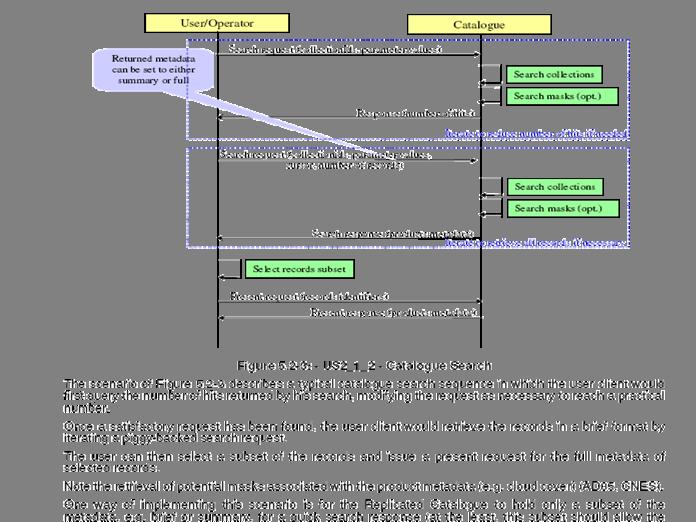
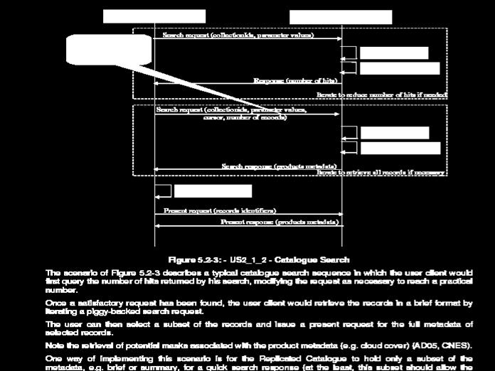
![Title: Author(s)/Organisation(s): Working Group: References: Quality Assurance: A5.2-D3 [3.7] Information Grounding Service Component Specification](/thumbs/80/81830659.jpg "Title: Author(s)/Organisation(s): Working Group: References: Quality Assurance: A5.2-D3 [3.7] Information Grounding Service Component Specification") Title: A5.2-D3 [3.7] Information Grounding Service Component Specification Author(s)/Organisation(s): Ana Belén Antón/ETRA Working Group: Architecture Team/WP05 References: A1.8-D5 User Involvement Document,
Title: A5.2-D3 [3.7] Information Grounding Service Component Specification Author(s)/Organisation(s): Ana Belén Antón/ETRA Working Group: Architecture Team/WP05 References: A1.8-D5 User Involvement Document,
WHAT ISINTEROPERABILITY? (AND HOW DO WE MEASURE IT?) INSPIRE Conference 2011 Edinburgh, UK
 INSPIRE Conference 2011 Edinburgh, UK") WHAT ISINTEROPERABILITY? (AND HOW DO WE MEASURE IT?) INSPIRE Conference 2011 Edinburgh, UK Motivation Interoperability is a core objective of INSPIRE Interoperability a major element of GEOSS Strategic
WHAT ISINTEROPERABILITY? (AND HOW DO WE MEASURE IT?) INSPIRE Conference 2011 Edinburgh, UK Motivation Interoperability is a core objective of INSPIRE Interoperability a major element of GEOSS Strategic
The GeoPortal Cookbook Tutorial
 The GeoPortal Cookbook Tutorial Wim Hugo SAEON/ SAEOS SCOPE OF DISCUSSION Background and Additional Resources Context and Concepts The Main Components of a GeoPortal Architecture Implementation Options
Global Monitoring for Environment and Security
 Global Monitoring for Environment and Security Final Report for the GMES Initial Period (2001-2003) Version 3.5 1 The GMES initiative was launched in May 1998 in Baveno and adopted by the ESA and EU Councils
Extension of INSPIRE Download Services TG for Observation Data
 Extension of INSPIRE Download Services TG for Observation Data Simon Jirka (52 North) 14 th June 2014, MIG Workshop on WCS-based INSPIRE Download Services Agenda Motivation Sensor Web Proposed Update for
Copernicus Space Component. Technical Collaborative Arrangement. between ESA. and. Enterprise Estonia
 Copernicus Space Component Technical Collaborative Arrangement between ESA and Enterprise Estonia 2 Table of Contents 1 INTRODUCTION... 4 1.1 Purpose and objectives... 4 1.2 Scope... 5 1.3 References...
Detailed analysis + Integration plan
 Outline Integration methodology Detailed analysis + Integration plan Conclusions 2 Outline Integration methodology Detailed analysis + Integration plan Conclusions 3 EULF-ISA Integration: methodology Phase
Proposed Revisions to ebxml Technical Architecture Specification v ebxml Business Process Project Team
 1 2 3 4 5 6 7 8 9 10 11 12 13 14 15 16 17 18 19 20 21 22 23 24 25 26 27 28 29 30 31 32 33 Proposed Revisions to ebxml Technical Architecture Specification v1.0.4 ebxml Business Process Project Team 11
Welcome. to Pre-bid meeting. Karnataka State Spatial Data Infrastructure (KSSDI) Project, KSCST, Bangalore.
 Project, KSCST, Bangalore.") Welcome to Pre-bid meeting Karnataka State Spatial Data Infrastructure (KSSDI) Project, KSCST, Bangalore. DEVELOPMENT OF KARNATAKA STATE SPATIAL DATA INFRASTRUCTURE (KSSDI) PROJECT Objective: To develop
Welcome to Pre-bid meeting Karnataka State Spatial Data Infrastructure (KSSDI) Project, KSCST, Bangalore. DEVELOPMENT OF KARNATAKA STATE SPATIAL DATA INFRASTRUCTURE (KSSDI) PROJECT Objective: To develop
FP7-INFRASTRUCTURES Grant Agreement no Scoping Study for a pan-european Geological Data Infrastructure D 4.4
 FP7-INFRASTRUCTURES-2012-1 Grant Agreement no. 312845 Scoping Study for a pan-european Geological Data Infrastructure D 4.4 Report on recommendations for implementation of the EGDI Deliverable number D4.4
Metadata Framework for Resource Discovery
 Submitted by: Metadata Strategy Catalytic Initiative 2006-05-01 Page 1 Section 1 Metadata Framework for Resource Discovery Overview We must find new ways to organize and describe our extraordinary information
Architecture Subgroup Report GEO4DOC 4.1(2) - REV 2.0 UPDATED - POST EO SUMMIT II 13 May 2004
 - REV 2.0 UPDATED - POST EO SUMMIT II 13 May 2004") Ad Hoc Group on Earth Observations (GEO) Report of the Subgroup on Architecture - (Report 2) The following Report of the GEO Subgroup on Architecture is composed of seven sections that collectively satisfy
Ad Hoc Group on Earth Observations (GEO) Report of the Subgroup on Architecture - (Report 2) The following Report of the GEO Subgroup on Architecture is composed of seven sections that collectively satisfy
Semantic Infrastructure and Platforms for Geospatial Services: A report from European Projects 4 th International Workshop on Semantic and
 Semantic Infrastructure and Platforms for Geospatial Services: A report from European Projects 4 th International Workshop on Semantic and Conceptual Issues in GIS (SeCoGIS 2010) Vancouver, Canada November
Multi-Community, Multi-Sensor Maritime Earth Observation DC
 Multi-Community, Multi-Sensor Maritime Earth Observation DC How do you eat the elephant? Gianluca Luraschi EO Project Manager and Application Architect Gianluca.luraschi@emsa.europa.eu SafeSeaNet Ecosystem
This document is a preview generated by EVS
 INTERNATIONAL STANDARD ISO 19119 Second edition 2016-01-15 Geographic information Services Information géographique Services Reference number ISO 19119:2016(E) ISO 2016 ISO 19119:2016(E) COPYRIGHT PROTECTED
INSPIRE: The ESRI Vision. Tina Hahn, GIS Consultant, ESRI(UK) Miguel Paredes, GIS Consultant, ESRI(UK)
 Miguel Paredes, GIS Consultant, ESRI(UK)") INSPIRE: The ESRI Vision Tina Hahn, GIS Consultant, ESRI(UK) Miguel Paredes, GIS Consultant, ESRI(UK) Overview Who are we? Introduction to ESRI Inc. and ESRI(UK) Presenters ArcGIS The ESRI Solution to
INSPIRE: The ESRI Vision Tina Hahn, GIS Consultant, ESRI(UK) Miguel Paredes, GIS Consultant, ESRI(UK) Overview Who are we? Introduction to ESRI Inc. and ESRI(UK) Presenters ArcGIS The ESRI Solution to
Proposed Revisions to ebxml Technical. Architecture Specification v1.04
 Proposed Revisions to ebxml Technical Architecture Specification v1.04 Business Process Team 11 May 2001 (This document is the non-normative version formatted for printing, July 2001) Copyright UN/CEFACT
Setting up the Ihlet Social Cadastre
 Setting up the Ihlet Social Cadastre Ihlet KHT Dr. Attila Molnár, GI consultant Bela Jarolics Rome, Italy TOPICS Goal of the project Architecture Database Solution Standards, communication Metadata Security
INSPIRE Download Service
 The OGC SOS as INSPIRE Download Service for (meteorological) l) Observation Data Simon Jirka (52 North) 29 th October 2014 5th Workshop on the use of GIS/OGC standards in meteorology Offenbach (Germany)
Monitoring the Environment for Climate Change: The case of GMES
 Monitoring the Environment for Climate Change: The case of GMES Presentation at 2008 IISL ECSL Symposium Legal Implications of Space Applications for Climate Change: Principles and Rules Dr. jur.gisela
EVOlution of EO Online Data Access Services (EVO-ODAS) ESA GSTP-6 Project by DLR, EOX and GeoSolutions (2015/ /04)
 ESA GSTP-6 Project by DLR, EOX and GeoSolutions (2015/ /04)") EVOlution of EO Online Data Access Services (EVO-ODAS) ESA GSTP-6 Project by DLR, EOX and GeoSolutions (2015/10 2017/04) 2016 Conference on Big Data from Space - BiDS 16, Tenerife, 15 th -17 th March Evolution
EVOlution of EO Online Data Access Services (EVO-ODAS) ESA GSTP-6 Project by DLR, EOX and GeoSolutions (2015/10 2017/04) 2016 Conference on Big Data from Space - BiDS 16, Tenerife, 15 th -17 th March Evolution
IHO S-100 Framework. The Essence. WP / Task: Date: Author: hansc/dga Version: 0.6. Document name: IHO S-100 Framework-The Essence
 WP / Task: 4.4.1. Date: 2015-09-25 Author: hansc/dga Version: 0.6 Document name: IHO S-100 Framework-The Essence IHO S-100 Framework Version 0.6 The Essence Document information More recent versions of
SEXTANT 1. Purpose of the Application
 SEXTANT 1. Purpose of the Application Sextant has been used in the domains of Earth Observation and Environment by presenting its browsing and visualization capabilities using a number of link geospatial
/// INTEROPERABILITY BETWEEN METADATA STANDARDS: A REFERENCE IMPLEMENTATION FOR METADATA CATALOGUES
 /// Position Paper /// INTEROPERABILITY BETWEEN METADATA STANDARDS: A REFERENCE IMPLEMENTATION FOR METADATA CATALOGUES /// Keywords: Public administration, Metadata, Geographical Information, Geospatial
Metadata allows. Metadata Existing Guidelines. Data to be found Starts interoperability. Decision making based on Quality Relevance Time Geography
 Metadata Existing Guidelines ADQ AIXM Workshop 10 December 2013 Eduard Porosnicu EUROCONTROL DSR/CMN/IM Metadata allows Data to be found Starts interoperability Decision making based on Quality Relevance
Spatial Data on the Web
 Spatial Data on the Web Tools and guidance for data providers The European Commission s science and knowledge service W3C Data on the Web Best Practices 35 W3C/OGC Spatial Data on the Web Best Practices
Addressing the needs of INSPIRE: The Challenges of improving Interoperability within the European Union
 Addressing the needs of INSPIRE: The Challenges of improving Interoperability within the European Union Andrew Coote Facilitator, Addresses Thematic Working Group andrew.coote@consultingwhere.com Disclaimer
HUMBOLDT Application Scenario: Protected Areas
 CC by Erlend Schei Copyright by Kecko Copyright by Michael Bezzina CC by Gunnar Ries Copyright by Michael Bezzina Copyright by Michael Bezzina Copyright by Michael Bezzina CC by fs999 CC by Jordan Nielsen
Open Geospatial Consortium
 Open Geospatial Consortium Date: 28-March-2011 Reference number of this document: 10-195 Editors: OGC Aviation Domain Working Group Requirements for Aviation Metadata Copyright 2011 Open Geospatial Consortium.
Using the OGC SOS as INSPIRE Download Service for Observation Data
 Using the OGC SOS as INSPIRE Download Service for Observation Data Simon Jirka (52 North) Alexander Kotsev (JRC) Michael Lutz (JRC) Matthes Rieke (52 North) Robin Smith (JRC) Paul Smits (JRC) 18 th June
GMES Status November 2004
 GMES Status November 2004 Peter BREGER DG RTD/H5 «Space: research activities, GMES» GMES GMES: a joint EC-ESA initiative The objective is to establish by 2008 a European capacity for global as well as
ETSI GS MEC-IEG 005 V1.1.1 ( )
") GS MEC-IEG 005 V1.1.1 (2015-08) GROUP SPECIFICATION Mobile-Edge Computing (MEC); Proof of Concept Framework Disclaimer This document has been produced and approved by the Mobile-Edge Computing (MEC) Industry
GS MEC-IEG 005 V1.1.1 (2015-08) GROUP SPECIFICATION Mobile-Edge Computing (MEC); Proof of Concept Framework Disclaimer This document has been produced and approved by the Mobile-Edge Computing (MEC) Industry
Data specifications and information structures for soils data. Stephen Hallett and Daniel Simms National Soil Resources Institute Cranfield University
 GSP Meeting Rome 22 March 2012 Stephen Hallett and Daniel Simms National Soil Resources Institute Cranfield University Landis.org.uk Rationalisation and harmonisation of soil legacy data (Jack Hannam)
Working Group Charter: Web Services Basic Profile
 Working Group Charter: Web Services Basic Profile Web Services Basic Profile (wsbasic) Creation Date: 2002.03.05 Revision Date: 2008.09.09 Document Editors: WS-I Secretary (secretary@ws-i.org) This Working
International Organization for Standardization Technical Committee 211 (ISO/TC211)
") Esri Support for Geospatial Standards: Open Geospatial Consortium (OGC) International Organization for Standardization Technical Committee 211 (ISO/TC211) An Esri White Paper April 2015 Copyright 2015
Esri Support for Geospatial Standards: Open Geospatial Consortium (OGC) International Organization for Standardization Technical Committee 211 (ISO/TC211) An Esri White Paper April 2015 Copyright 2015
Infrastructure for Spatial Information in Europe. Proposed action for update of MIWP: Alternative encodings for INSPIRE data
 INSPIRE Infrastructure for Spatial Information in Europe Proposed action for update of MIWP: Alternative encodings for INSPIRE data Type Creator MIWP Action fiche DG ENV Date/status/version 20/11/2017
CEN Workshop Standards Compliant Formats for Fatigue Test Data (FaTeDa) Project Plan
 Project Plan") 1 2016-01-15 CEN Workshop Standards Compliant Formats for Fatigue Test Data (FaTeDa) Project Plan 1. Status of the Project Plan Approved at the kick-off meeting on 2016-01-11. 2. Background of the Workshop
1 2016-01-15 CEN Workshop Standards Compliant Formats for Fatigue Test Data (FaTeDa) Project Plan 1. Status of the Project Plan Approved at the kick-off meeting on 2016-01-11. 2. Background of the Workshop
Strong Customer Authentication and common and secure communication under PSD2. PSD2 in a nutshell
 Strong Customer Authentication and common and secure communication under PSD2 PSD2 in a nutshell Summary On August 12, the EBA has issued the long-awaited draft of the Regulatory Technical Standards (RTS)
The EOC Geoservice: Standardized Access to Earth Observation Data Sets and Value Added Products ABSTRACT
 The EOC Geoservice: Standardized Access to Earth Observation Data Sets and Value Added Products K. Dengler, T. Heinen, A. Huber, K. Molch, E. Mikusch German Aerospace Center (DLR) German Remote Sensing
Monitoring and Reporting Drafting Team Monitoring Indicators Justification Document
 INSPIRE Infrastructure for Spatial Information in Europe Monitoring and Reporting Drafting Team Monitoring Indicators Justification Document Title Draft INSPIRE Monitoring Indicators Justification Document
Draft INSPIRE Implementing Rule on Metadata
 Document: D/GIS/97/EN Original Meeting of the Working Party "Geographical Information Systems for Statistics" Joint meeting with National Statistical Offices and National Mapping Agencies Luxembourg, March
Open Geospatial Consortium
 Open Geospatial Consortium Approval Date: 2012-02-17 Publication Date: 2012-06-12 External identifier of this OGC document: http://www.opengis.net/doc/bp/cat-eo-ebxml-rim-3.0 Reference number of this document:
The UK Marine Environmental Data and Information Network MEDIN
 The UK Marine Environmental Data and Information Network MEDIN M. Charlesworth, R. Lowry, H. Freeman, J. Rapaport, B Seeley Content MEDIN - a brief overview for context Discovery Metadata Standard and
CGMS WMO Task Force on Metadata Implementation Progress. Presented to IPET-SUP agenda item 12.2
 CGMS WMO Task Force on Metadata Implementation Progress Presented to IPET-SUP 17-03-2015 agenda item 12.2 Overview CGMS-WMO-Task Force on Metadata Implementation Refresher Why such Task Force Task Force
preparation of National Action Plans on youth employment the process of developing the NAP
 preparation of National Action Plans on youth employment the process of developing the NAP module 3 1 outline suggested partnerships in NAP development and their role national institutions and partners
Download Service Implementing Rule and Technical Guidance
 Download and Transformation Draft Implementing Rules Presentation for INSPIRE Initiatives Download Service Implementing Rule and Technical Guidance Olaf Østensen Statens kartverk Norwegian Mapping Authority
The AAA Model as Contribution to the Standardisation of the Geoinformation Systems in Germany
 The AAA Model as Contribution to the Standardisation of the Geoinformation Systems in Germany Markus SEIFERT, Germany Key words: ISO, CEN, OGC, AdV, Spatial Data Infrastructure SUMMARY Germany is a classic
ISO INTERNATIONAL STANDARD. Financial services Universal financial industry message scheme Part 8: ASN.1 generation
 INTERNATIONAL STANDARD ISO 20022-8 First edition 2013-05-01 Financial services Universal financial industry message scheme Part 8: ASN.1 generation Services financiers Schéma universel de messages pour
This document is a preview generated by EVS
 TECHNICAL REPORT RAPPORT TECHNIQUE TECHNISCHER BERICHT CEN/TR 15449-5 April 2015 ICS 07.040; 35.240.70 English Version Geographic information - Spatial data infrastructures - Part 5: Validation and testing
PortalU, a Tool to Support the Implementation of the Shared Environmental Information System (SEIS) in Germany
 in Germany") European conference of the Czech Presidency of the Council of the EU TOWARDS eenvironment Opportunities of SEIS and SISE: Integrating Environmental Knowledge in Europe http:/www.e-envi2009.org/proceedings/
European conference of the Czech Presidency of the Council of the EU TOWARDS eenvironment Opportunities of SEIS and SISE: Integrating Environmental Knowledge in Europe http:/www.e-envi2009.org/proceedings/
ISO/IEC/ IEEE INTERNATIONAL STANDARD. Systems and software engineering Architecture description
 INTERNATIONAL STANDARD ISO/IEC/ IEEE 42010 First edition 2011-12-01 Systems and software engineering Architecture description Ingénierie des systèmes et des logiciels Description de l'architecture Reference
The Open Group SOA Ontology Technical Standard. Clive Hatton
 The Open Group SOA Ontology Technical Standard Clive Hatton The Open Group Releases SOA Ontology Standard To Increase SOA Adoption and Success Rates Ontology Fosters Common Understanding of SOA Concepts
EarthLookCZ as Czech way to GMES
 EarthLookCZ as Czech way to GMES Karel Charvat 1 and Petr Horak 1 1 WirelessInfo, Czech Republic, charvat@wirelessinfo.cz Abstract Global Monitoring for Environment and Security is one of 4 ranges of solutions
GMES The EU Earth Observation Programme
 GMES The EU Earth Observation Programme Ondřej Mirovský Czech Space Office, Prvního Pluku 17, Prague 8, 186 00, Czech Republic mirovsky@czechspace.cz Abstract. The paper describes evolution, recent development
Geographical Base Registries for Flanders
 Geographical Base Registries for Flanders Ziggy Vanlishout Flemish Geographical Information Agency Layout FGIA (Flemish Geographical Information Agency) Project 'Geographical Base Registries' Data Modelling
Stakeholder Participation Guidance
 Climate, Community & Biodiversity Alliance, Verra Stakeholder Participation Guidance Guidance to support stakeholder participation in design, implementation and assessment of policies and actions May 2018
strategy IT Str a 2020 tegy
 strategy IT Strategy 2017-2020 Great things happen when the world agrees ISOʼs mission is to bring together experts through its Members to share knowledge and to develop voluntary, consensus-based, market-relevant
Working Group Charter: Basic Profile 1.2 and 2.0
 Working Group Charter: Basic Profile 1.2 and 2.0 1 2 3 4 5 6 7 8 9 10 11 12 13 14 15 16 17 18 19 20 21 22 23 24 25 26 27 28 29 30 31 32 33 34 35 36 37 38 39 40 41 42 43 44 45 46 47 48 49 Web Services Basic
Workshop Data Modelling [en]
![Workshop Data Modelling [en]](/thumbs/87/95069410.jpg "Workshop Data Modelling [en]") Workshop Data Modelling [en] Thorsten Reitz, wetransform INSPIRE and Beyond 2018 24.05.2018 Wetransform GmbH - Why do we create data models at all? - What processes can we use to create models? - What
Workshop Data Modelling [en] Thorsten Reitz, wetransform INSPIRE and Beyond 2018 24.05.2018 Wetransform GmbH - Why do we create data models at all? - What processes can we use to create models? - What
Earth Science Community view on Digital Repositories
 Ground European Network for Earth Science Interoperations Digital Repository Dissemination and Exploitation of GRids in Earth science Earth Science Community view on Digital Repositories Luigi FUSCO -
Introduction to INSPIRE. Network Services
 Introduction to INSPIRE. Network Services European Commission Joint Research Centre Institute for Environment and Sustainability Digital Earth and Reference Data Unit www.jrc.ec.europa.eu Serving society
ESRI & Interoperability. David Danko ISO TC 211 Metadata Project Leader OGC Metadata WG Chair ESRI Senior Consultant GIS Standards
 ESRI & Interoperability David Danko ISO TC 211 Metadata Project Leader OGC Metadata WG Chair ESRI Senior Consultant GIS Standards ddanko@esri.com GIS has always required Interoperability Social Factors
Introduction to Prod-Trees
 European Geosciences Union General Assembly 2014 Prod Trees Bernard Valentin Vienna Austria 29 April 2014 Outline 2 Background Prod-Trees Project RARE Project and Platform Status Future Background (ESA)
Enterprise Architecture Method
 OIO Enterprise Introduction to the OIO Enterprise Method (OIO ) Version 1.0 and X1. X2. A1. -related challenges A3. Method Foundation A5. Vision, Goals and Strategies B1. Objects B3. Services B5. UseCases
OG0-091 Q&As TOGAF 9 Part 1
 CertBus.com OG0-091 Q&As TOGAF 9 Part 1 Pass The Open Group OG0-091 Exam with 100% Guarantee Free Download Real Questions & Answers PDF and VCE file from: 100% Passing Guarantee 100% Money Back Assurance
Sustainable Consumption and Production
 Sustainable Consumption and Production Resolution 2/8 Charles Arden-Clarke Head, Secretariat 10 Year Framework of Programmes on Sustainable Consumption and Production/One Planet Network CPR Meeting 28
Call for Participation in AIP-6
 Call for Participation in AIP-6 GEOSS Architecture Implementation Pilot (AIP) Issue Date of CFP: 9 February 2013 Due Date for CFP Responses: 15 March 2013 Introduction GEOSS Architecture Implementation
This document is a preview generated by EVS
 TECHNICAL SPECIFICATION ISO/TS 19163-1 First edition 2016-01-15 Geographic information Content components and encoding rules for imagery and gridded data Part 1: Content model Information géographique
Designing a System Engineering Environment in a structured way
 Designing a System Engineering Environment in a structured way Anna Todino Ivo Viglietti Bruno Tranchero Leonardo-Finmeccanica Aircraft Division Torino, Italy Copyright held by the authors. Rubén de Juan
Compass INSPIRE Services. Compass INSPIRE Services. White Paper Compass Informatics Limited Block 8, Blackrock Business
 Compass INSPIRE Services White Paper 2010 Compass INSPIRE Services Compass Informatics Limited Block 8, Blackrock Business Park, Carysfort Avenue, Blackrock, County Dublin, Ireland Contact Us: +353 1 2104580
Understanding and Using Metadata in ArcGIS. Adam Martin Marten Hogeweg Aleta Vienneau
 Understanding and Using Metadata in ArcGIS Adam Martin Marten Hogeweg Aleta Vienneau Adam Martin National Government Account Management R&D Open Data Marten Hogeweg National Government Professional Services