Using Free and Open Source GIS to Automatically Create Standards- Based Spatial Metadata
|
|
|
- Jessie McLaughlin
- 6 years ago
- Views:
Transcription
1 Using Free and Open Source GIS to Automatically Create Standards- Based Spatial Metadata Claire Ellul University College London
2 Overview The Problem with Metadata Automation Results Further Work
3 The Problem with Metadata Metadata Is data about data Gives you important information such as When the data was created Who by For what purpose When it was updated How to obtain the data
4 The Problem with Metadata However.... Metadata is boring!
5 The Problem with Metadata and Metadata is: Complex and time consuming to create Requires expertise about the data Requires expertise about how to create useful metadata How much detail should be included? Who are the end users of the metadata? Requires MAINTENANCE when data changes!
6 Metadata Automation Many elements of standards-based metadata may potentially be automatically created including: Keywords Dataset language Metadata language FOSS tools provide a great environment for this!
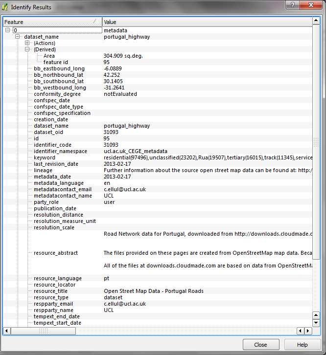
7 Metadata Element Resource Title Resource Abstract Resource Type Resource language Keyword(s) Bounding Box Metadata language Last Revision Date Automation Potential Created manually. If not inserted by the user, default value is the dataset name (i.e. the PostGIS table name). Created manually. Can default to dataset. Automatically populated by PostGIS Can be automated using language detection algorithms This could be implemented by concatenating all text fields of the dataset and picking the top 10 repeating words while eliminating common words. Can be automatically identified from the spatial coordinates in the dataset This can be detected by applying a language detection algorithm to the metadata Automatically update the metadata when the data changes
8 Metadata Element Metadata Date Responsible Party Metadata Contact Resource Identifier Metadata Geometry Automation Potential Automatically defaults to the date the metadata was created/updated Can be populated automatically depending on the login (user id) for PostGIS Can be populated automatically depending on the login (user id) for PostGIS Can be automatically generated using the metadata record ID PostgreSQL identifiers Automatically created as a spatial geometry in PostGIS
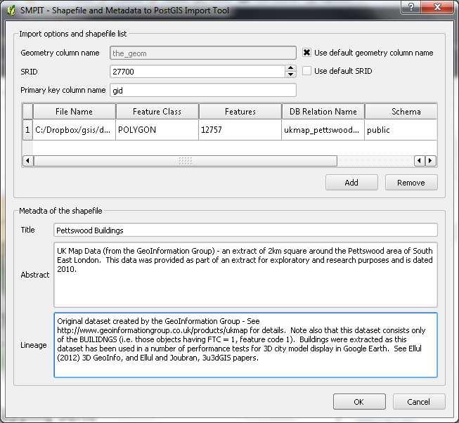
9 Quantum GIS - Data Import: 1. Shapefile to PostGIS 2. Metadata automatically created (Other import tools to be added) Any GIS - Data Editing: 1. Users can search metadata spatially or via text (SQL) 2. Metadata automatically updated if data edited Future: Web Services WFS, WMS, Catalog Based on the stored Data and Metadata PostGIS 2.0 Database Spatial Datasets Metadata Tight Coupling (Triggers)
10 Triggers in PostGIS CREATE OR REPLACE FUNCTION public.add_boundingbox() RETURNS trigger AS $boundingbox$ -- this trigger function calculates the bounding box (Xmin, Xmax, Ymin, Ymax) of a new dataset added to the database and inserts it in the metadata table Declare Begin End; table_name text; --variable that holds the name of the table (i.e. dataset) the_coord real; -- used to store the long/lat values curs1 refcursor; -- used to hold SQL query results. the trigger code goes here $boundingbox$ LANGUAGE plpgsql VOLATILE; -- VOLATILE indicates that the function value can change
11 Triggers in PostGIS Open curs1 FOR EXECUTE CLOSE curs1; 'SELECT ST_XMax(ST_Extent(ST_Transform(the_geom,4326))) as the_coord FROM ' table_name; FETCH curs1 into the_coord; EXECUTE 'UPDATE metadata SET bb_eastbound_long = ' the_coord ' WHERE dataset_name = ' quote_literal(table_name);
12 Triggers in PostGIS A series of INSERT triggers are run every time a new metadata record is created: CREATE TRIGGER add_boundingbox AFTER INSERT ON public.metadata FOR EACH ROW EXECUTE PROCEDURE public.add_boundingbox(); A series of metadata update triggers are run every time a dataset is modified, e.g.: CREATE TRIGGER roaddata_bb_update AFTER INSERT OR UPDATE OR DELETE on roaddata FOR EACH ROW EXECUTE PROCEDURE update_bounding_box_roaddata(); ** NB: A new version of this trigger function is created automatically when a new spatial dataset is inserted into the database.


13 Add Bounding Box (PL/pgSQL Trigger) Select the minimum Longitude, transforming into WGS84 if required Repeat for minimum latitude, maximum longitude and latitude Insert the values into the metadata table columns Create a trigger to run this process every time the dataset is edited
14 Identifying Keywords Identify Text Fields in the Data Set (PL/pgSQL Trigger) Split any text into single words using the space character as delimiter Create a single column list of all the words using the SQL UNION query Use an SQL GROUP BY query to identify the 10 most frequently used words
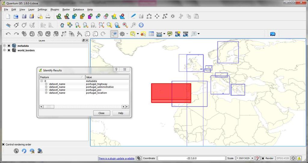
15 Testing the System Metadata was created for Open Street Map datasets: Points of interest, administrative boundaries, road network and location data And for 10 European countries UK, Austria, Greece, Malta, Italy, Spain, Belgium, Netherlands, Portugal, Sweden
16
17
18 Points of Interest Keywords - Keywords were in English and included: - Public, Services, Tourism, Tree, Automotive Location Data Keywords Keywords were predominantly in English and included locality, hamlet, village Also included place names: Aachen, Birmingham, Munchen, Trento
19 Administrative Areas Keywords For keywords, the datasets yielded numbers such as 8, 6, 9, 10 in some cases Road Network Keywords Keywords were predominantly in English and included track, footway, cycleway Also included the words for street in other languages: via (Italian) calle (Spanish), strasse (Austria)
20 Summary Results Using FOSS (in particular PostGIS) means that the resulting data and metadata can be accessed from other GIS packages Metadata is automatically updated when data is modified No matter which software is used to edit the data Using a central database means that the data and metadata can be published via OGC services such as WFS and Catalog Service for Web
21 Further Work Testing with additional, more appropriate, single language datasets from different sources Extending the system to allow metadata to be created automatically for ANY spatial data in a PostGIS database, no matter how it is loaded Publishing the data and metadata via tools such as GeoServer
22 Further Work Identify and resolve any issues related to performance i.e. the time taken to create the metadata each time the data is modified. Improve handling of non-latin character-sets Thinking about deployment how to ensure that the approach can be used by users not having spatial database expertise
23 Any Questions?
24 Metadata Element Resource Title Resource Abstract Resource Type Resource language Keyword(s) Bounding Box Date of publication Date of last revision Automation Potential Created manually. If not inserted by the user, default value is the dataset name. Created manually. Can default to dataset Can be automated using language detection algorithms This could be implemented by concatenating all text fields of the dataset and picking the top 10 repeating words while eliminating common words. Can be automatically identified from the spatial coordinates in the dataset Can default to the date that data was uploaded to the system, with updates when the data is edited. Manual verification required by the end user. Default to the date the data was uploaded to the system. Update automatically any time data edited
25 Metadata Element Date of creation Limitations on public access and conditions of use (2 elements) Responsible party name, and role (3 elements) Metadata contact name, and date (3 elements) Metadata language Automation Potential Default to the date the data was uploaded. Manual verification required by the end user Given the academic context, a default value can be assigned, perhaps taking the most open value or perhaps on a per project basis. Based on user groups (identified from the user s login details and a corresponding lookup table). This can be derived from the database login of the person uploading the dataset or creating the new dataset. This can be detected by applying a language detection algorithm to the metadata
26 The Problem with Metadata Metadata is important for academic research: The EU FP7 project SECOA is developing models of coastal conflicts in countries including Italy, India, the UK, Portugal, Israel, Vietnam, Sweden and Belgium Data underpins these models
27 The Problem with Metadata Metadata is important for academic research: However, comparable data is not always available so alternative data is sometimes substituted In the Italian case, the total Employees in industrial sector in Rome is not available. The number of employees was not available so the number of local units in the industrial sector has been used Without this metadata, the SECOA team could be comparing employees with industrial units!
28
Gower Street, London, WC1E 6BT UK Tel. +44 (0) Fax +44 (0) PB Wageningen, The Netherlands
 Fax +44 (0) PB Wageningen, The Netherlands") Automating Standards-Based Metadata Creation using Free and Open Source GIS Tools Claire Ellul 1, Nart Tamash 1, Feng Xian 1, John Stuiver 2, Patrick Rickles 1 1 Department of Civil, Environmental and
Automating Standards-Based Metadata Creation using Free and Open Source GIS Tools Claire Ellul 1, Nart Tamash 1, Feng Xian 1, John Stuiver 2, Patrick Rickles 1 1 Department of Civil, Environmental and
Using Free and Open Source GIS to Automatically Create Standards-Based Spatial Metadata in Academia - First Investigations
 Free and Open Source Software for Geospatial (FOSS4G) Conference Proceedings Volume 13 FOSS4G 2013 Full Conference Proceedings (papers), Nottingham, UK. Article 8 2013 Using Free and Open Source GIS to
Setting up the Ihlet Social Cadastre
 Setting up the Ihlet Social Cadastre Ihlet KHT Dr. Attila Molnár, GI consultant Bela Jarolics Rome, Italy TOPICS Goal of the project Architecture Database Solution Standards, communication Metadata Security
Statistical Viewer. Coping with the Complexity
 Statistical Viewer Coping with the Complexity Overview What s DataCove and Ghosting EuroStat as a Data Resource DataCove Statistical Viewer The Way from Here to There Conclusions What We Do Data Modelling:
ewater SDI for water resource management
 PROJECT GEONETCAST WS 2009/2010 ewater SDI for water resource management Technical Documentation Theresia Freska Utami & Wu Liqun 2/12/2010 I. GEONETWORK 1. Installation e-water uses the software package
Introduction to GeoServer
 Tutorial ID: This tutorial has been developed by BVIEER as part of the IGET web portal intended to provide easy access to geospatial education. This tutorial is released under the Creative Commons license.
Relation between Geospatial information projects related to GBIF
 Relation between Geospatial information projects related to GBIF Synthesys 3.6-Synthesys 3.7-GBIF.DE- BioGeomancer The most up to date work can always be found at: http://www.biogeografia.com/synthesys
Managing Translations for Blaise Questionnaires
 Managing Translations for Blaise Questionnaires Maurice Martens, Alerk Amin & Corrie Vis (CentERdata, Tilburg, the Netherlands) Summary The Survey of Health, Ageing and Retirement in Europe (SHARE) is
World Premium Points of Interest Getting Started Guide
 World Premium Points of Interest Getting Started Guide Version: 2.0 NOTICE: Copyright Pitney Bowes 2017. All Rights Reserved. 1 Table of Contents INTRODUCTION... 3 1. Preface... 3 2. Data Characteristics...
WFD Art. V groundwater body data gap analysis
 EEA/ADS/06/001 Water WFD Art. V groundwater body data gap analysis Version: 2.0 Date: 15 September, 2008 EEA activity: ETC/Water task.milestone.submilestone: Task 4.2 Prepared by / compiled by: Vit Kodes
Compass INSPIRE Services. Compass INSPIRE Services. White Paper Compass Informatics Limited Block 8, Blackrock Business
 Compass INSPIRE Services White Paper 2010 Compass INSPIRE Services Compass Informatics Limited Block 8, Blackrock Business Park, Carysfort Avenue, Blackrock, County Dublin, Ireland Contact Us: +353 1 2104580
Welcome to Verizon Business Internet Global Utilization Statistics
 1 Introduction Welcome to Verizon Business Internet Global Utilization Statistics Dear customer In this document you will find information in general about IGUS, how to login to the Verizon Business Customer
World Premium Points of Interest Getting Started Guide
 World Premium Points of Interest Getting Started Guide Version: 2.3 NOTICE: Copyright Pitney Bowes 2019. All Rights Reserved. 1 Table of Contents INTRODUCTION... 3 1. Preface... 3 2. Data Characteristics...
NFMS web portals Focus on monitoring functions
 NFMS web portals Focus on monitoring functions National Forest Monitoring System web portal to disseminate forest-related geospatial data on the web Dr. Inge Jonckheere, FAO UN-REDD October 2014, Hanoi,
Common European Submission Portal
 Common European Submission Portal Presenter: Kevin Horan Title: ICT Director email: kevin.horan@hpra.ie Common European Submission Portal CESP: A simple and secure mechanism for exchange of information
User Manual for the delivery of a new national Natura 2000 database to the Commission. Version 1.1
 User Manual for the delivery of a new national Natura 2000 database to the Commission Version 1.1 The Natura 2000 network of protected sites consists of the sites classified under the Birds Directive first
Supplier Invoice Submission Guide. English
 Supplier Invoice Submission Guide English Date: May 2 nd, 2017 1 Table of Contents How to submit an invoice through the SWIM... 3 How to access the SWIM... 3 Submitting a PO invoice... 4 Creating an invoice...
World Premium Points of Interest Getting Started Guide
 World Premium Points of Interest Getting Started Guide Version: 0.1 1 Table of Contents INTRODUCTION... 3 1. Preface... 3 2. Data Characteristics... 3 3. Loading the data into RDMS Databases... 3 Oracle...
Items exceeding one or more of the maximum weight and dimensions of a flat. For maximum dimensions please see the service user guide.
 Rate Card International Flats Effective from 2 April 2013 Pricing your mail Once you have selected the service you wish to use, calculate the price using the tables on the following pages. For more information
From data source to data view: A practical guide to uploading spatial data sets into MapX
 From data source to data view: A practical guide to uploading spatial data sets into MapX Thomas Piller UNEP/GRID Geneva I Table of contents 1. Adding a new data source to MapX... 1 1.1 Method 1: upload
ARCHITECTURE OF SPATIAL DATA INFRASTRUCTURE (SDI) (DRAFT)
 (DRAFT)") ARCHITECTURE OF SPATIAL DATA INFRASTRUCTURE (SDI) (DRAFT) Author: Carlo Cipolloni September 20, 2018 Version 1.0 A SDI platform to support the SEIS in the ENP South region Introduction Based on the Contribution
ARCHITECTURE OF SPATIAL DATA INFRASTRUCTURE (SDI) (DRAFT) Author: Carlo Cipolloni September 20, 2018 Version 1.0 A SDI platform to support the SEIS in the ENP South region Introduction Based on the Contribution
DanubeGIS User Manual Document number: Version: 1 Date: 11-Nov-2016
 DanubeGIS User Manual Document number: Version: 1 Date: 11-Nov-2016 Imprint Published by: ICPDR International Commission for the Protection of the Danube River ICPDR 2016 Contact ICPDR Secretariat Vienna
Introduction to the Dimensionally Extended 9 Intersection Model (DE-9IM) in PostgreSQL/PostGIS Tutorial
 in PostgreSQL/PostGIS Tutorial") Introduction to the Dimensionally Extended 9 Intersection Model (DE-9IM) in PostgreSQL/PostGIS Tutorial Germán Carrillo gcarrillo@uni-muenster.de geotux_tuxman@linuxmail.org Objectives Following this tutorial
Introduction to the Dimensionally Extended 9 Intersection Model (DE-9IM) in PostgreSQL/PostGIS Tutorial Germán Carrillo gcarrillo@uni-muenster.de geotux_tuxman@linuxmail.org Objectives Following this tutorial
Mississippi Public Schools 2015
 Mississippi Public Schools 2015 Shapefile and geodatabase Tags education, administrative, schools, public, K-12 Summary To add to the state data clearinghouse the Mississippi public schools point feature.
EarthLookCZ as Czech way to GMES
 EarthLookCZ as Czech way to GMES Karel Charvat 1 and Petr Horak 1 1 WirelessInfo, Czech Republic, charvat@wirelessinfo.cz Abstract Global Monitoring for Environment and Security is one of 4 ranges of solutions
Configuring a Microstrategy Resource in Metadata Manager 9.5.0
 Configuring a Microstrategy Resource in Metadata Manager 9.5.0 2012 Informatica Corporation. No part of this document may be reproduced or transmitted in any form, by any means (electronic, photocopying,
County of Los Angeles. Chief Information Office Preferred Technologies for Geographic Information Systems (GIS) Version 2 May 2015
 Version 2 May 2015") County of Los Angeles Chief Information Office Preferred Technologies for Geographic Information Systems (GIS) Version 2 May 2015 CIO Preferred Technologies for GIS This document lists the preferred Geographic
County of Los Angeles Chief Information Office Preferred Technologies for Geographic Information Systems (GIS) Version 2 May 2015 CIO Preferred Technologies for GIS This document lists the preferred Geographic
PROCESSING ZOOPLA HISTORIC DATA
 Number of Adverts PROCESSING ZOOPLA HISTORIC DATA Rod Walpole Scientific Computing Officer Urban Big Data Centre Zoopla has over 27 million residential property records in their archive although only a
WORKSHOP ON ALL WEEE FLOWS 14/02/17 Alberto Canni Ferrari ERP Italy Country General Manager
 WORKSHOP ON ALL WEEE FLOWS 14/02/17 Alberto Canni Ferrari ERP Italy Country General Manager ENGINEERING CIRCULAR ECONOMY www.landbell-group.com WORKSHOP ON ALL WEEE FLOWS ERP ITALY & THE LANDBELL GROUP
Croatian Motorways Road Database Management System
 Croatian Motorways Road Database Management System Marko Turković FOSS4G-Europe 2014 Presentation overview About us System introduction System component architecture Kosmo Desktop WebGIS portal Future
The European Commission s science and knowledge service. Joint Research Centre
 The European Commission s science and knowledge service Joint Research Centre GeoDCAT-AP The story so far Andrea Perego, Antonio Rotundo, Lieven Raes GeoDCAT-AP Webinar 6 June 2018 What is GeoDCAT-AP Geospatial
Sberbank Online User Guide
 Sberbank Online User Guide Contents 1. Introduction... 2 1.1 Available services... 2 1.2 Security... 2 2. First use... 3 2.1 Login... 3 2.2 Password change... 3 2.3 PIN change... 5 2.3 User profile...
The power of PostgreSQL exposed with automatically generated API endpoints. Sylvain Verly Coderbunker 2016Postgres 中国用户大会 Postgres Conference China 20
 The power of PostgreSQL exposed with automatically generated API endpoints. Sylvain Verly Coderbunker Development actors Frontend developer Backend developer Database administrator System administrator
GUIDE TO ONLINE APPLICATION FOR SPACE Individual and Group Applications 15 May 2013
 GUIDE TO ONLINE APPLICATION FOR SPACE Individual and Group Applications 15 May 2013 Save as Draft function The Save as Draft function allows exhibitors to save their application at any stage of the application
INSPIRE roadmap and architecture: lessons learned INSPIRE 2017
 INSPIRE roadmap and architecture: lessons learned INSPIRE 2017 Stijn Goedertier GIM Thierry Meessen GIM Jeff Konnen ACT Luxembourg Patrick Weber ACT Luxembourg 1 Administration du cadastre et de la topographie
ISESS An Integrated Decision-Support Information System on the Impact of Extreme Natural Hazards on Critical Infrastructure
 ISESS 2017 An Integrated Decision-Support Information System on the Impact of Extreme Natural Hazards on Critical Infrastructure Dr Zoheir Sabeur et al University of Southampton IT Innovation Centre, UK.
International Telecommunication Union
 1 The views expressed in this paper are those of the author and do not necessarily reflect the opinions of the ITU or its Membership. Broadband competition: Penetration, speed and price Taylor Reynolds
Introduction to INSPIRE. Network Services
 Introduction to INSPIRE. Network Services European Commission Joint Research Centre Institute for Environment and Sustainability Digital Earth and Reference Data Unit www.jrc.ec.europa.eu Serving society
Professional, quality services
 Professional, quality services 001 Translations offers you the expertise that it has gathered in doing business internationally for more than 20 years. International coverage In-house translation of 10
Verwaltung und Qualitätssicherung von BIM-Modellen via IFCWebServer.org Data Server
 Verwaltung und Qualitätssicherung von BIM-Modellen via IFCWebServer.org Data Server Ali Ismail M.Sc. TU Dresden Institut für Bauinformatik Development Leader @ IFCWebServer.org Content Short introduction
Putting the Pieces together: Combining Open Source Components to create a WebGIS.
 Putting the Pieces together: Combining Open Source Components to create a WebGIS. Shriram Ilavajhala University of Maryland College Park, MD. USA. Today s Topics A quick background on our project Our legacy
GeoNode Intro & Demo
 GeoNode Intro & Demo Cristiano Giovando - Global Facility for Disaster Reduction and Recovery, World Bank Paolo Corti - Center for Geographic Analysis, Harvard University Dynamic Mapping of Secondary Cities
CUSTOMER GUIDE Interoute One Bridge Outlook Plugin Meeting Invite Example Guide
 CUSTOMER GUIDE Interoute One Bridge Outlook Plugin Meeting Invite Example Guide Version History Version Date Title 1.0 04/10/17 Initial document All quotes, offers or proposals are (i) made based on Interoute
EUROPEAN READY-MIXED CONCRETE INDUSTRY STATISTICS YEAR
 ERMCO EUROPEAN READY MIXED CONCRETE ORGANIZATION ASSOCIATION EUROPEENNE DU BETON PRET A L EMPLOI EUROPÄISCHER TRANSPORTBETONVERBAND EUROPEAN READY-MIXED CONCRETE INDUSTRY STATISTICS YEAR 2006 September
Country-specific notes on Waste Electrical and Electronic Equipment (WEEE)
") EUROPEAN COMMISSION EUROSTAT Directorate E: Sectoral and regional statistics E-2: Environmental Statistics and Accounts; Sustainable Development Country-specific notes on Waste Electrical and Electronic
EUROPEAN COMMISSION EUROSTAT Directorate E: Sectoral and regional statistics E-2: Environmental Statistics and Accounts; Sustainable Development Country-specific notes on Waste Electrical and Electronic
Schema transformations in mass data harmonization process. Yohann Ly 8/9 Octobre 2013 Marne la Vallée
 Schema transformations in mass data harmonization process Yohann Ly 8/9 Octobre 2013 Marne la Vallée Mass data harmonization process Problematic : Multiple data providers Multiple storage format Multiple
The Butterfly Effect. A proposal for distribution and management for butterfly data programs. Dave Waetjen SESYNC Butterfly Workshop May 10, 2012
 The Butterfly Effect A proposal for distribution and management for butterfly data programs Dave Waetjen SESYNC Butterfly Workshop May 10, 2012 http://butterfly.ucdavis.edu Citizen Science based Observation
DELIVERABLE D12.6/12.7 IECM Database Extension & User Interface with Tabulator
 Project N : 262608 ACRONYM: Data without Boundaries DELIVERABLE D12.6/12.7 IECM Database Extension & User Interface with Tabulator WORK PACKAGE 12 Implementing Improved Resource Discovery for OS Data REPORTING
CRE investment weakens in Q as investors struggle to find product in prime markets
 2006.3 2007.1 2007.3 2008.1 2008.3 2009.1 2009.3 2010.1 2010.3 2011.1 2011.3 2012.1 2012.3 2013.1 2013.3 2014.1 2014.3 2015.1 2015.3 2016.1 Europe Capital Markets, Q1 2016 CRE investment weakens in Q1
Technology Platform. Spectrum. Version 10.0 SP1. Spectrum Spatial Getting Started Guide
 Spectrum Version 10.0 SP1 Technology Platform Table of Contents 1 - What Is Location Intelligence? 2 - What is Spectrum Spatial? Spectrum Spatial Concepts 5 3 - Modules and Stages Location Intelligence
5 Extract the information of location from the geometry column of PostgreSQL table
 5 Extract the information of location from the geometry column of PostgreSQL table Open QGIS and load PostGIS layer buildings and the raster layer Tai_wide_G (optional just to show the basemap). 1 Click
Key Terms. Attribute join Target table Join table Spatial join
 Key Terms Attribute join Target table Join table Spatial join Lect 10A Building Geodatabase Create a new file geodatabase Map x,y data Convert shape files to geodatabase feature classes Spatial Data Formats
MOBILE AND WEB GIS APPLICATION FOR MAPPING AND MONITORING LAND FEATURES
 MOBILE AND WEB GIS APPLICATION FOR MAPPING AND MONITORING LAND FEATURES Michelle V. Japitana*, Melbert R. Bonotan, Roel G. Damalerio 1 Assoc. Professor College of Engineering & Information Techonology
INSPIRE: The ESRI Vision. Tina Hahn, GIS Consultant, ESRI(UK) Miguel Paredes, GIS Consultant, ESRI(UK)
 Miguel Paredes, GIS Consultant, ESRI(UK)") INSPIRE: The ESRI Vision Tina Hahn, GIS Consultant, ESRI(UK) Miguel Paredes, GIS Consultant, ESRI(UK) Overview Who are we? Introduction to ESRI Inc. and ESRI(UK) Presenters ArcGIS The ESRI Solution to
INSPIRE: The ESRI Vision Tina Hahn, GIS Consultant, ESRI(UK) Miguel Paredes, GIS Consultant, ESRI(UK) Overview Who are we? Introduction to ESRI Inc. and ESRI(UK) Presenters ArcGIS The ESRI Solution to
RadiantBlue Technologies, Inc. Page 1
 vpiazza RadiantBlue Technologies, Inc. Page 1 vpiazza Enabling Government Teams to Share and Access Data in the Cloud in 2016 Michael P. Gerlek mgerlek@radiantblue.com 4 May 2016 RadiantBlue Technologies,
Web Map Servers. Mark de Blois. Septembre 2016
 Web Map Servers Mark de Blois Septembre 2016 Learning Objectives After this lecture you will be able to understand web map servers as used in Web-GIS applications Introduction A Web Map Server is a computer
HUMBOLDT Application Scenario: Protected Areas
 CC by Erlend Schei Copyright by Kecko Copyright by Michael Bezzina CC by Gunnar Ries Copyright by Michael Bezzina Copyright by Michael Bezzina Copyright by Michael Bezzina CC by fs999 CC by Jordan Nielsen
This document is a preview generated by EVS
 TECHNICAL SPECIFICATION SPÉCIFICATION TECHNIQUE TECHNISCHE SPEZIFIKATION CEN ISO/TS 19139 November 2009 ICS 35.240.70 English Version Geographic information - Metadata - XML schema implementation (ISO/TS
International Packets
 Rate Card International Packets Effective from 2 April 2013 Pricing your mail Once you have selected the service you wish to use, calculate the price using the tables on the following pages. For more information
InCLUDE Data Exchange. Julia Harrell, GISP GIS Coordinator, NC DENR
 InCLUDE Data Exchange Julia Harrell, GISP GIS Coordinator, NC DENR Julia.harrell@ncdenr.gov InCLUDE Project Partners NC Department of Environment & Natural Resources: The State of NC s lead environmental
Networking Session - A trusted cloud ecosystem How to help SMEs innovate in the Cloud
 Networking Session - A trusted cloud ecosystem How to help SMEs innovate in the Cloud ICT2015, 21 October 2015 Lisbon, Portugal Dr. Paolo Balboni, Partner at ICT Legal Consulting & Scientific Director
This document is a preview generated by EVS
 TECHNICAL REPORT RAPPORT TECHNIQUE TECHNISCHER BERICHT CEN/TR 15449-5 April 2015 ICS 07.040; 35.240.70 English Version Geographic information - Spatial data infrastructures - Part 5: Validation and testing
PostgreSQL/PostGIS: Introduction
 PostgreSQL/PostGIS: Introduction Introduction PostgreSQL A standards-compliant SQL-based database server with which a wide variety of client applications can communicate Server software generally, but
Real Estate Sales, New York NY, 2014
 Page 1 of 6 Metadata format: ISO 19139 Real Estate Sales, New York NY, 2014 ISO 19139 metadata content Resource Identification Information Spatial Representation Information Reference System Information
International Roaming Critical Information Summaries JULY 2017
 Critical Information Summaries JULY 2017 Phone: Email: Website: Information about the service. Here s a quick summary of all the important bits about your Postpaid SkySmart Mobile International Roaming
pgrouting extends the postgis/postgresql geospatial database to provide geospatial routing and other network analysis functionality.
 Workshop: 1 pgrouting extends the postgis/postgresql geospatial database to provide geospatial routing and other network analysis functionality. Attendee s previous knowledge: SQL (PostgreSQL, PostGIS)
Open source technologies and INSPIRE network services in Slovak environmental agency
 Open source technologies and INSPIRE network services in Slovak environmental agency Peter Mozolík, Martin Koška, Marek Žiačik, Martin Tuchyňa Slovak Environmental Agency (SEA) SEA role within slovak SDI
ArcGIS Server: publishing geospatial data to the web using the EEA infrastructure
 ArcGIS Server: publishing geospatial data to the web using the EEA infrastructure *IMPORTANT: Map Services should be published using the EEA Map Services Tick Sheet for guidance. Contact Sebastien Petit
THE BEST OF ICT WITH A HUMAN TOUCH
 THE BEST OF ICT WITH A HUMAN TOUCH VINCI & VINCI ENERGIES WORLDWIDE PLAYER IN CONCESSIONS & CONSTRUCTION VINCI ENERGIES IS A DIVISION OF VINCI Technology Roads Construction Concessions VINCI VINCI Energies
ESHI Diploma THE EUROPEAN SPECIALISATION IN TRANSPLANTATION IMMUNOLOGY, HISTOCOMPATIBILITY & IMMUNOGENETICS
 ESHI Diploma THE EUROPEAN SPECIALISATION IN TRANSPLANTATION IMMUNOLOGY, HISTOCOMPATIBILITY & IMMUNOGENETICS Union Européene des Medecins Spécialistes (UEMS) Section of Surgery Division of Transplantation
Data Model and Management
 Data Model and Management Ye Zhao and Farah Kamw Outline Urban Data and Availability Urban Trajectory Data Types Data Preprocessing and Data Registration Urban Trajectory Data and Query Model Spatial Database
Spectrum Spatial Map Uploader Guide
 Spectrum Spatial Map Uploader Version 11.0 Spectrum Spatial Map Uploader Guide Welcome to Spectrum Spatial Map Uploader. To get started with the Spectrum Spatial Map Uploader, refer to the following help
Quickly design labels and signs with Brady Workstation Apps. 30 day free trial for every app!
 Quickly design labels and signs with Brady Workstation Apps 30 day free trial for every app! Design any label with Brady Workstation apps Brady Workstation offers professional, intuitive apps to design
Training courses. Course Overview Details Audience Duration. Applying GIS
 Training courses (Last update: December 2017) Remarks: As part of a course a certificate is issued for each attendee. All software used during the courses is Open Source Software. Contact: allspatial Geospatial
Mapping, Visualization, and Digitization of the Geo-Referenced Information: A case study on Road Network Development in Near Real Time
 Mapping, Visualization, and Digitization of the Geo-Referenced Information: A case study on Road Network Development in Near Real Time Ronak Jain 1, Himansi Bhatt 2, Nithya Jeevanand 2, Praveen Kumar 3
This document is a preview generated by EVS
 TECHNICAL SPECIFICATION SPÉCIFICATION TECHNIQUE TECHNISCHE SPEZIFIKATION CEN/TS 15844-5 December 2010 ICS 03.240 English Version Postal services - ID-tagging of letter mail items - Part 5: 4-state encoding
This document is a preview generated by EVS
 EESTI STANDARD EVS-EN 12283:2003 Printing and business paper - Determination of toner adhesion Printing and business paper - Determination of toner adhesion EESTI STANDARDIKESKUS EESTI STANDARDI EESSÕNA
EU funded research is keeping up trust in digital society
 EU funded research is keeping up trust in digital society Rafael Tesoro Trust and Security Unit DG Communica5ons Networks, Content and Technology European Commission Cybersecurity Strategy of the EU: An
Networking European Digital Repositories
 Networking European Digital Repositories What to Network? Researchers generate knowledge This is going to become an amazing paper I only hope I will be able to access it Knowledge is wrapped in publications
Part 2: Build your own Map Tour with ArcGIS Online
 Part 2: Build your own Map Tour with ArcGIS Online Tutorial Overview In this tutorial, students will create and publish their own Map Tour application, a type of Story Map Web application, through ArcGIS
European Cybersecurity PPP European Cyber Security Organisation - ECSO November 2016
 European Cybersecurity PPP European Cyber Security Organisation - ECSO November 2016 Présentation Géraud Canet geraud.canet@cea.fr ABOUT THE CYBERSECURITY cppp 3 AIM 1. Foster cooperation between public
MapInfo Professional Evolution!
 MapInfo Professional Evolution! A long history of improvement This presentation covers what is new in all of the MapInfo Pro releases since v9.0! MapInfo Pro Release History A feature release every year
Setting Up and Deploying Geospatial Data Shares Using the QGIS Server Application
 Setting Up and Deploying Geospatial Data Shares Using the QGIS Server Application Donald L. Schrupp Wildlife Ecologist Colorado Division of Wildlife (retired) Quantum GIS (QGIS) Applications QGIS is not
Spotfire Extension for OpenSpirit User s Guide
 Spotfire Extension for OpenSpirit User s Guide Software Release 1.0.0 August 2012 Important Information SOME TIBCO SOFTWARE EMBEDS OR BUNDLES OTHER TIBCO SOFTWARE. USE OF SUCH EMBEDDED OR BUNDLED TIBCO
file:///c:/users/c_harmak/appdata/local/temp/arc8f36/tmp308d.tmp.htm
 Page 1 of 6 FireDistricts_CoB Shapefile Tags Bradenton, boundary, fire districts Summary The best current representation of the City of Bradenton Florida's fire districts and sub-districts. Description
Basic Tasks in ArcGIS 10.3.x
 Basic Tasks in ArcGIS 10.3.x This guide provides instructions for performing a few basic tasks in ArcGIS 10.3.1, such as adding data to a map document, viewing and changing coordinate system information,
Learn Well Technocraft
 Getting Started with ASP.NET This module explains how to build and configure a simple ASP.NET application. Introduction to ASP.NET Web Applications Features of ASP.NET Configuring ASP.NET Applications
Customers want to transform their datacenter 80% 28% global IT budgets spent on maintenance. time spent on administrative tasks
 Customers want to transform their datacenter 80% global IT budgets spent on maintenance 28% time spent on administrative tasks Cloud is a new way to think about your datacenter Traditional model Dedicated
Fast 3D EMC/EMI Scan with Detectus Scanning System and Tektronix Real Time Spectrum Analyzers CASE STUDY
 Fast 3D EMC/EMI Scan with Detectus Scanning System and Tektronix Real Time Spectrum Analyzers Fast 3D EMC/EMI Scan with Detectus Scanning System and Tektronix Real Time Spectrum Analyzers Customer Solution
Corporate R&D The Case of ICT Companies
 ICT in Europe: a socio-economic approach 20-21 January 2011 1 Corporate R&D The Case of ICT Companies Main results from The 2010 Report on R&D in ICT in the European Union Paul Desruelle Institute for
List of nationally authorised medicinal products
 27 January 2016 EMA/194278/2016 Procedure Management and Committees Support Active substance: Gadoteric acid (IV and intravascular formulations) Procedure no.: PSUSA/00001506/201504 30 Churchill Place
Insights for Clubs
 Insights for Clubs - 2015 Enjoying success requires the ability to adapt. Only by being open to change will you have a true opportunity to get the most from your Market. Key consumer trends Diverse population
u D i g W a l k t h r o u g h 2 E d i t w i t h u D i g a n d W F S - T
 E di t wi th ud ig a nd WFS -T Table of Contents 1 Introduction... 3 2 WMS and WFS Integration... 4 3 Editing Geometry with WFS... 8 4 Working with Attributes... 11 5 Exporting to Shape file... 14 6 Take
Observation trends: Expectations from European Comission regarding data exchange and interoperability
 Observation trends: Expectations from European Comission regarding data exchange and interoperability Marcin Wichorowski (IO PAN), Sławomir Sagan (IO PAN), Declan Dunne (UCC MaREI), John Barton (UCC-TYNDALL)
INSPIRE Download Services of the CNIG (Spain) Emilio López Romero
 Emilio López Romero") INSPIRE Download Services of the CNIG (Spain) Emilio López Romero 1 The beginning One day, few years ago, we decided to implement INSPIRE seriously 2 The sources The first step was to identify the available
INSPIRE Download Services of the CNIG (Spain) Emilio López Romero 1 The beginning One day, few years ago, we decided to implement INSPIRE seriously 2 The sources The first step was to identify the available
D4.4 Procedures GIS Update System report. FORCIP+: Forest Roads for Civil Protection
 D4.4 Procedures GIS Update System report. FORCIP+: Forest Roads for Civil Protection Project title Call identifier Project acronym Forest Roads for Civil Protection (FORCIP+) Call for proposals 2015 for
Analysis of the Interoperability Possibilities of Implemented Governmental e-services EU15
 InterPARES Trust Study Name: Team & Study Number: Research domain: Document Title: Analysis of the Interoperability Possibilities of Implemented Governmental e-services EU15 Control Checklist Status: Final
BoR (10) 13. BEREC report on Alternative Retail Voice and SMS Roaming Tariffs and Retail Data Roaming Tariffs
 13. BEREC report on Alternative Retail Voice and SMS Roaming Tariffs and Retail Data Roaming Tariffs") BEREC report on Alternative Retail Voice and SMS Roaming Tariffs and Retail Data Roaming Tariffs March 2010 1. Background Regulation 544/2009 of 18 June 2009 on international roaming 1 requires all operators
BEREC report on Alternative Retail Voice and SMS Roaming Tariffs and Retail Data Roaming Tariffs March 2010 1. Background Regulation 544/2009 of 18 June 2009 on international roaming 1 requires all operators
Tutorial 2: Query and Select TRI Spatial Data to Study State-Wide Emissions Quantum GIS
 Tutorial 2: Query and Select TRI Spatial Data to Study State-Wide Emissions Quantum GIS This tutorial will introduce you to the following: Identifying Attribute Data Sources Toxic Release Inventory (TRI)
ICT Legal Consulting on GDPR: the possible value of certification in data protection compliance and accountability
 ICT Legal Consulting on GDPR: the possible value of certification in data protection compliance and accountability Prof. Dr. Paolo Balboni Founding Partner Professor of Privacy, Cybersecurity, and IT Contract