Introduction to INSPIRE. Network Services
|
|
|
- Adam Craig
- 6 years ago
- Views:
Transcription


1 Introduction to INSPIRE. Network Services European Commission Joint Research Centre Institute for Environment and Sustainability Digital Earth and Reference Data Unit Serving society Stimulating innovation Supporting legislation
2 INSPIRE recap EU-wide SDI perspective on data Ultimate goal is to unlock spatial data and lay down foundations of European SDI INSPIRE is a Framework Directive Into force since 15 th of May 2007 Detailed technical provisions are laid down in: Implementing Rules on Metadata Spatial Data Network services Data and Service sharing (policy) 2
3 INSPIRE principles Data should be collected once Possible to combine data from different sources Focus on information relevant for governance Focus on reusability GI should be easily discoverable, together with its metadata Distributed Service Oriented Architecture (SOA) 3
 Legally binding for public administrations with data in scope Business aspects of INSPIRE Rapidly growing geospatial sector")
4 Value added of INSPIRE Building blocks for interoperable SDI in the following context Cross-country Cross-domain Combination of the above Harmonization and standardization of environmental data across Europe (and beyond) Legally binding for public administrations with data in scope Business aspects of INSPIRE Rapidly growing geospatial sector 4
5 INSPIRE Thematic Scope Annex I Coordinate reference systems Geographical grid systems Geographical names Administrative units Addresses Annex II Elevation Land cover Ortho-imagery Geology Annex III Statistical units Buildings Soil Land use Human health and safety Area management/restriction/ regulation zones & reporting units Natural risk zones Atmospheric conditions & Meteorological geographical features Oceanographic geographical features Sea regions Cadastral parcels Transport networks Hydrography Protected sites Utility and governmental services Environmental monitoring facilities Production and industrial facilities Agricultural and aquaculture facilities Population distribution demography Also Generic Conceptual Model, Observations & Measures Bio-geographical regions Habitats and biotopes Species distribution Energy resources Mineral resources 5
6 6
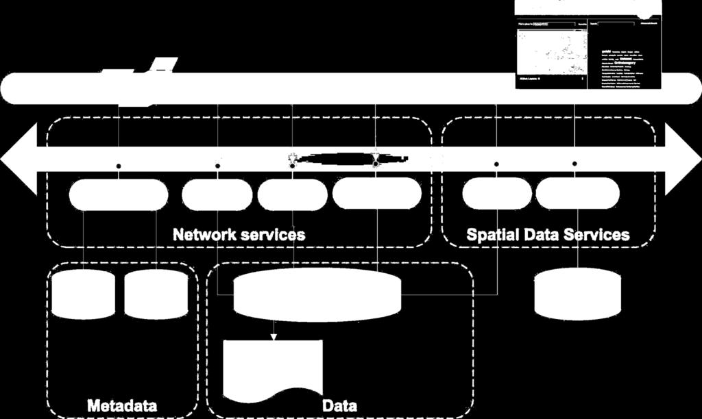
7 INSPIRE architecture 7

8 INSPIRE Roadmap for Implementation 2020 All Annex II+III data 2012 Download and transformation services 2011 Discovery and view services 2010 Metadata Annex I and II 2018 All Annex I data 2015 New Annex II and III data interoperable 2013 New Annex I data interoperable Harmonized conditions for access to data Metadata Annex III 8

9 Implementing Rules vs. Technical Guidelines 9


10 2. Relevant components 10

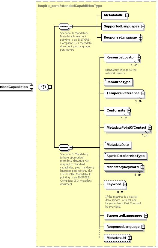
 No")
 No")
11 INSPIRE Implementing Rules (IRs) No 1089/2010 (Annex I) No 102/2011 (code values Annex I) No 1253/ Oct

")


12 Technical Guidelines (TG-Data Specification) Framework Documents TG Annex I, Annex II & III Metadata & services Interoperability of spatial data sets & services 12
 freely extensible values included in IRs and any other values are allowed d) empty any values are allowed For code lists of types (b), (c) and (d), additional values have to be published")
13 Code lists 4 types of INSPIRE code lists according to extensibility a) not extensible only values included in IRs are allowed b) narrower extensible values included in IRs and narrower values are allowed c) freely extensible values included in IRs and any other values are allowed d) empty any values are allowed For code lists of types (b), (c) and (d), additional values have to be published in a register TG-DS may include additional proposed values that will be published in the INSPIRE code list register 13

14 UML models, xml schemas, registers, that what JRC delivers & maintains 14
 Open to external contributions http://inspire.ec.europa.")
15 Relevant components INSPIRE Registry Online service for common identifiers and definitions for data encoding purposes registers: code lists, themes, application schemas, fcd browsing and accessing register content Formats: HTML, XML, Atom, JSON and RDF/SKOS Multilingual content (based on IR content) Open to external contributions 15

 3. Download Web Feature Service Atom feeds 4.")
16 Relevant components INSPIRE Network services In INSPIRE data should be made available where best managed 1. Discover Expose metadata through INSPIRE compliant discovery service 2. View Interactive view of data through an INSPIRE compliant data service Unified portrayal through OGC Styled Layer Descriptor (SLD) 3. Download Web Feature Service Atom feeds 4. Transform ETL 16


17 Relevant components INSPIRE Geoportal Central access point to the INSPIRE infrastructure and resources ( ) Connection to all MS network services cross-border data discovery and visualisation support to policy making 17
18 Discovery services 18

19 INSPIRE Metadata Distinguish between Spatial object metadata Dataset-level metadata Tools available at JRC site INSPIRE Metadata editor INSPIRE metadata validator 19

20 Metadata editor 20

21 Discovery services discovery services making it possible to search for spatial data sets and services on the basis of the content of the corresponding metadata and to display the content of the metadata 21
22 Operations (Article 11(1) of Directive 2007/2/EC) 1. Get Discovery Service Metadata: Provides all necessary information about the service and describes service capabilities 2. Discover Metadata: The Discover Metadata operation allows requesting INSPIRE metadata elements of resources based on a query statement to be retrieved from the target Discovery Service 3. Publish Metadata: The Publish Metadata operation allows editing INSPIRE metadata elements of resources in the Discovery Service (push or pull metadata mechanisms). Editing meaning insert, update and delete 4. Link Discovery Service: The Link Discovery Service function allows the declaration of the availability of a Discovery Service for the discovery of resources through the Member State Discovery Service while maintaining the resource metadata at the owner location 22

23 View Services 23


24 View services view services making it possible, as a minimum, to display, navigate, zoom in/out, pan, or overlay viewable spatial data sets and to display legend information and any relevant content of metadata 24

25 View services INSPIRE View Services allow users and computer programs to view spatial datasets. 25
26 TG for View services TG for View services specifies requirements and recommendations based on the European de jure standard [ISO 19128] Web Map Service (WMS) It defines an INSPIRE Profile of [ISO 19128] INSPIRE Profile of [ISO 19128] also make use of the OGC Styled Layer Descriptor (SLD) 26
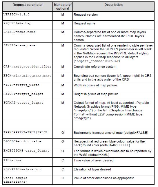
27 Operations 1. Get View Services Metadata: Get metadata about a specific view service; 2. Get Map: Returns a map for a specified area; 3. Link View Service: Allows the linking of view services together. 27
28 GetViewService metadata 28
29 GetViewService metadata 29
30 GetMap 30
31 GetMap Naming: 31
32 Link View Service Allows a Public Authority or a Third Party to declare a View Service for the viewing of its resources through: Member State View Service while maintaining the viewing capability at the Public Authority or the Third party location. 32

33 View and discovery services at INSPIRE Geoportal 33
34 Download services 34

35 Download services download services, enabling copies of spatial data sets, or parts of such sets, to be downloaded and, where practicable, accessed directly 35
36 Download services Predefined o Whole datasets Direct access o Provides access to spatial objects based upon a query Service implementation Predefined dataset download service Direct access download service WCS X X SOS X X WFS Х Х Atom Х 36
37 Operations Predefined + Direct access Get Download Service Metadata Get Spatial Data Set Describe Spatial Data Set Link Download Service Get Spatial Object (direct access only) Describe Spatial Object Type (direct access only) 37
38 INSPIRE Download services Available options (now) Atom feeds WFS (Web Feature Service) Work ongoing for INSPIRE compliant download service based on OGC Sensor Observation Service (SOS), MIWP-7a OGC Web Coverage Service (WCS), MIWP-7b 38
39 Examples of Download services 39
40 Architectures for INSPIRE implementation. Available technology European Commission Joint Research Centre Institute for Environment and Sustainability Digital Earth and Reference Data Unit Serving society Stimulating innovation Supporting legislation
41 Transformation relationships can be complex origin conformant transformation simple transformation - renaming, assign new properties complex transformation - reclassification, geometry calulation 41


42 Transformation relationships can be complex origin conformant transformation simple transformation - renaming, assign new properties complex transformation - reclassification, geometry calulation 42

43 Transformation... is an ETL repeatable procces analytical task 43
? need to maintain, don t forget approach (operational process) will the data set in future +/- static, e.g. geology under frequently change, e.")
44 architectural approaches, an Overview One-off transformation + external web based services Atom/WFS/ One-the-fly transformation Atom/WFS/ Hybrid transformation + integrated web based services Atom/WFS/ Consider for choosing an but what happened with changes (update)? need to maintain, don t forget approach (operational process) will the data set in future +/- static, e.g. geology under frequently change, e.g. land use under permanent change e.g. air quality reporting 44

45 One-off transformation + external web based services positive aspects are: transformed once for all users better performance when delivering the data no transformation during delivery Wide choice of software components negative aspects are: Requires storage and management of transformed data in addition to original data high processing effort the entire database is transformed to be maintained also transformed data This approach is useful if data are stable 45

46 On the fly transformation+ integrated web services positive aspects are: only the original data has to be maintained only the requested data has to be transformed eg. Snowflake/GoLoader/-PublisherWFS, GeoServer (?) negative aspects are: Performance issues high processing required before delivery especially for large volumes of data and complex transformations the same data is potentially transformed multiple times Caching or pre-processing mechanisms has to be used This approach is useful if data is continuously or frequently updated 46

47 One-off transformation + DB + integrated web based services eg. ArcGIS for INSPIRE positive aspects are: Data transformed offline can be managed in same system as original data e.g. in the same database management negative aspects are: Data provider still has to store transformed data Limited FOSS-GIS solutions (current) system, not as GML files On-the-fly get more performance because of predefined data structure This approach is useful if data is continuously or frequently updated 47
48 Technology for implementation 48
49 49
50 50

51 Some popular solutions 51
52 Thanks 52
INSPIRE overview and possible applications for IED and E-PRTR e- Reporting Alexander Kotsev
 INSPIRE overview and possible applications for IED and E-PRTR e- Reporting Alexander Kotsev www.jrc.ec.europa.eu Serving society Stimulating innovation Supporting legislation The European data puzzle 24
INSPIRE & Environment Data in the EU
 INSPIRE & Environment Data in the EU Andrea Perego Research Data infrastructures for Environmental related Societal Challenges Workshop @ pre-rda P6 Workshops, Paris 22 September 2015 INSPIRE in a nutshell
Compass INSPIRE Services. Compass INSPIRE Services. White Paper Compass Informatics Limited Block 8, Blackrock Business
 Compass INSPIRE Services White Paper 2010 Compass INSPIRE Services Compass Informatics Limited Block 8, Blackrock Business Park, Carysfort Avenue, Blackrock, County Dublin, Ireland Contact Us: +353 1 2104580
INSPIRE in a nutshell, and overview of the European Union Location Framework
 INSPIRE in a nutshell, and overview of the European Union Location Framework Francesco Pignatelli European Commission, DG JRC 10 th European Congress and Exhibition on Intelligent Transport Systems and
Sub-national dimensions of INSPIRE
 www.eurogeographics.org CONNECTING YOU TO THE Sub-national dimensions of INSPIRE SDIs in the evolving EU society Dave Lovell, Secretary General and Executive Director 24 June 2013 Copyright 2013 EuroGeographics
Initial Operating Capability & The INSPIRE Community Geoportal
 INSPIRE Conference, Rotterdam, 15 19 June 2009 1 Infrastructure for Spatial Information in the European Community Initial Operating Capability & The INSPIRE Community Geoportal EC INSPIRE GEOPORTAL TEAM
Building a missing item in INSPIRE: The Re3gistry
 Building a missing item in INSPIRE: The Re3gistry www.jrc.ec.europa.eu Serving society Stimulating innovation Supporting legislation Key pillars of data interoperability Conceptual data models Encoding
Consolidation Team INSPIRE Annex I data specifications testing Call for Participation
 INSPIRE Infrastructure for Spatial Information in Europe Technical documents Consolidation Team INSPIRE Annex I data specifications testing Call for Participation Title INSPIRE Annex I data specifications
European Location Framework (ELF) acting as a facilitator implementing INSPIRE
 acting as a facilitator implementing INSPIRE") www.eurogeographics.org European Location Framework (ELF) acting as a facilitator implementing INSPIRE Saulius Urbanas, Mick Cory (EuroGeographics) 29 October 2016 Copyright 2013 EuroGeographics EuroGeographics
www.eurogeographics.org European Location Framework (ELF) acting as a facilitator implementing INSPIRE Saulius Urbanas, Mick Cory (EuroGeographics) 29 October 2016 Copyright 2013 EuroGeographics EuroGeographics
Web Coverage Services (WCS)
") Web Coverage Services (WCS) www.jrc.ec.europa.eu Thematic Cluster #3 Jordi Escriu Facilitator Thematic Cluster #3 Serving society Stimulating innovation Supporting legislation Coverages in INSPIRE Coverage:
Web Coverage Services (WCS) www.jrc.ec.europa.eu Thematic Cluster #3 Jordi Escriu Facilitator Thematic Cluster #3 Serving society Stimulating innovation Supporting legislation Coverages in INSPIRE Coverage:
INSPIRE Data Specifications What s new? What s next?
 INSPIRE Data Specifications What s new? What s next? Michael Lutz INSPIRE Conference 25 th June 2013, Firenze www.jrc.ec.europa.eu Serving society Stimulating innovation Supporting legislation What s new?
From the INSPIRE Engine Room
 From the INSPIRE Engine Room Michael Lutz ENiiG Conference, Lisbon 9 November 2016 Joint Research Centre the European Commission's in-house science service The JRC's role in INSPIRE Support MS in implementation
INSPIRE: The ESRI Vision. Tina Hahn, GIS Consultant, ESRI(UK) Miguel Paredes, GIS Consultant, ESRI(UK)
 Miguel Paredes, GIS Consultant, ESRI(UK)") INSPIRE: The ESRI Vision Tina Hahn, GIS Consultant, ESRI(UK) Miguel Paredes, GIS Consultant, ESRI(UK) Overview Who are we? Introduction to ESRI Inc. and ESRI(UK) Presenters ArcGIS The ESRI Solution to
INSPIRE: The ESRI Vision Tina Hahn, GIS Consultant, ESRI(UK) Miguel Paredes, GIS Consultant, ESRI(UK) Overview Who are we? Introduction to ESRI Inc. and ESRI(UK) Presenters ArcGIS The ESRI Solution to
Marine and Coastal Data Services in the Cloud. Richard Rombouts - Snowflake Software Ltd. & Keiran Millard SeaZone Solutions Ltd.
 Marine and Coastal Data Services in the Cloud Richard Rombouts - Snowflake Software Ltd. & Keiran Millard SeaZone Solutions Ltd. Marine Geospatial Data Inspired Marine Data? SeaZone HydroSpatial Global
INSPIRE status report
 INSPIRE Team INSPIRE Status report 29/10/2010 Page 1 of 7 INSPIRE status report Table of contents 1 INTRODUCTION... 1 2 INSPIRE STATUS... 2 2.1 BACKGROUND AND RATIONAL... 2 2.2 STAKEHOLDER PARTICIPATION...
Extension of INSPIRE Download Services TG for Observation Data
 Extension of INSPIRE Download Services TG for Observation Data Simon Jirka (52 North) 14 th June 2014, MIG Workshop on WCS-based INSPIRE Download Services Agenda Motivation Sensor Web Proposed Update for
Providing INSPIRE measurement data. K. Schleidt, S. Grellet, A. Sarretta, P. Tagliolato, A. Kotsev
 Providing INSPIRE measurement data K. Schleidt, S. Grellet, A. Sarretta, P. Tagliolato, A. Kotsev Part 1. Introduction Context 10 years ago o Geospatial information was hardly (if at all) exchanged in
Guidelines for the encoding of spatial data
 INSPIRE Infrastructure for Spatial Information in Europe Guidelines for the encoding of spatial data Title Status Creator Date 2012-06-15 Subject Publisher Type Description Contributor Format Source Rights
Spatial Data on the Web
 Spatial Data on the Web Tools and guidance for data providers The European Commission s science and knowledge service W3C Data on the Web Best Practices 35 W3C/OGC Spatial Data on the Web Best Practices
Landslide Damage on Chemin de Fer de la Mure near Grenoble,
 Contents 1 What is the INSPIRE directive, and why is it important?... 3 1.1 What is the aim of this document?... 4 1.2 Who will this document be useful to?... 4 2 An overview of INSPIRE specifications...
UN-GGIM: Europe core data and adaptation of INSPIRE models Dominique Laurent (IGN)
") Workshop about extensions of INSPIRE data specifications 20-21 June 2017 UN-GGIM: Europe core data and adaptation of INSPIRE models Dominique Laurent (IGN) UN-GGIM General presentation UN-GGIM(United Nations
Workshop about extensions of INSPIRE data specifications 20-21 June 2017 UN-GGIM: Europe core data and adaptation of INSPIRE models Dominique Laurent (IGN) UN-GGIM General presentation UN-GGIM(United Nations
The cadastral data and standards based on XML in Poland
 The cadastral data and standards based on XML in Poland Jarosław Bydłosz, Piotr Parzych AGH University of Science and Technology Cracow, Poland 1 XML XML Extensible Markup Language Extensible Markup Language
Basic Principles of MedWIS - WISE interoperability
 Co-ordination committee seminar of the national focal points Basic Principles of MedWIS - WISE interoperability Eduardo García ADASA Sistemas Nice - France Agenda WISE vs MedWIS WISE WISE DS WISE vs WISE
Standards, standardisation & INSPIRE Status, issues, opportunities
 Standards, standardisation & INSPIRE Status, issues, opportunities INSPIRE Coordination Team 6 th MIG meeting, 13-14 June 2017 Joint Research Centre The European Commission's science and knowledge service
Integration of INSPIRE & SDMX data infrastructures for the 2021 population and housing census
 Integration of INSPIRE & SDMX data infrastructures for the 2021 population and housing census Nadezhda VLAHOVA, Fabian BACH, Ekkehard PETRI *, Vlado CETL, Hannes REUTER European Commission (*ekkehard.petri@ec.europa.eu
Spatial Data on the Web
 Spatial Data on the Web Tools and guidance for data providers Clemens Portele, Andreas Zahnen, Michael Lutz, Alexander Kotsev The European Commission s science and knowledge service Joint Research Centre
INSPIRE tools What's new?
 INSPIRE tools What's new? Michael Lutz INSPIRE Conference, Antwerp 18 September 2018 Joint Research Centre The European Commission s science and knowledge service INSPIRE reference validator Why a reference
INSPIRE Download Service
 The OGC SOS as INSPIRE Download Service for (meteorological) l) Observation Data Simon Jirka (52 North) 29 th October 2014 5th Workshop on the use of GIS/OGC standards in meteorology Offenbach (Germany)
Toward Horizon 2020: INSPIRE, PSI and other EU policies on data sharing and standardization
 Toward Horizon 2020: INSPIRE, PSI and other EU policies on data sharing and standardization www.jrc.ec.europa.eu Serving society Stimulating innovation Supporting legislation The Mission of the Joint Research
v1.0 Session: Database creation (theory) Pier-Giorgio Zaccheddu
 Pier-Giorgio Zaccheddu") Session: Database creation (theory) v1.0 Pier-Giorgio Zaccheddu Federal Agency for Cartography and Geodesy (BKG) Richard-Strauss-Allee 11 60598 Frankfurt am Main Tel.: +49 69 6333 305 Fax: +49 69 6333
Session: Database creation (theory) v1.0 Pier-Giorgio Zaccheddu Federal Agency for Cartography and Geodesy (BKG) Richard-Strauss-Allee 11 60598 Frankfurt am Main Tel.: +49 69 6333 305 Fax: +49 69 6333
MetOcean Themes in INSPIRE
 MetOcean Themes in INSPIRE Cliquez pour modifier le style du titre 4th Workshop on the use of GIS/OGC standards in meteorology Cliquez pour modifier le style des sous-titres Frédéric du Guillaud masque
The European Soil Data Centre, the European Soil Bureau Network and INSPIRE Data Specifications for Soil
 The European Soil Data Centre, the European Soil Bureau Network and INSPIRE Data Specifications for Soil Marc Van Liedekerke, Panos Panagos, Luca Montanarella Land Management and Natural Harzards Unit
Using the OGC SOS as INSPIRE Download Service for Observation Data
 Using the OGC SOS as INSPIRE Download Service for Observation Data Simon Jirka (52 North) Alexander Kotsev (JRC) Michael Lutz (JRC) Matthes Rieke (52 North) Robin Smith (JRC) Paul Smits (JRC) 18 th June
DanubeGIS User Manual Document number: Version: 1 Date: 11-Nov-2016
 DanubeGIS User Manual Document number: Version: 1 Date: 11-Nov-2016 Imprint Published by: ICPDR International Commission for the Protection of the Danube River ICPDR 2016 Contact ICPDR Secretariat Vienna
How to Create a European INSPIRE Compliant Data Specification. Anja Hopfstock, BKG (Germany) Morten Borrebæk, SK (Norway)
 Morten Borrebæk, SK (Norway)") How to Create a European INSPIRE Compliant Data Specification Anja Hopfstock, BKG (Germany) Morten Borrebæk, SK (Norway) ESDIN Key Goals Further the ambition of the European Commission to create a European
How to Create a European INSPIRE Compliant Data Specification Anja Hopfstock, BKG (Germany) Morten Borrebæk, SK (Norway) ESDIN Key Goals Further the ambition of the European Commission to create a European
Tutorial International Standards. Web Map Server (WMS) & Web Feature Server (WFS) Overview
 & Web Feature Server (WFS) Overview") ISO/TC 211 17 th Plenary & Associated Meetings Berlin, Germany, DIN Institute / 2003-10-31 Advisory Group on Outreach Tutorial International Standards Web Map Server (WMS) & Web Feature Server (WFS) Overview
ISO/TC 211 17 th Plenary & Associated Meetings Berlin, Germany, DIN Institute / 2003-10-31 Advisory Group on Outreach Tutorial International Standards Web Map Server (WMS) & Web Feature Server (WFS) Overview
Testing - an essential aspect of establishing an SDI
 Testing - an essential aspect of establishing an SDI Clemens Portele, Anders Östman, Michael Koutroumpas, Xin He, Janne Kovanen, Markus Schneider, Andriani Skopeliti INSPIRE Conference 2011 30 June 2011
International Organization for Standardization Technical Committee 211 (ISO/TC211)
") Esri Support for Geospatial Standards: Open Geospatial Consortium (OGC) International Organization for Standardization Technical Committee 211 (ISO/TC211) An Esri White Paper April 2015 Copyright 2015
Esri Support for Geospatial Standards: Open Geospatial Consortium (OGC) International Organization for Standardization Technical Committee 211 (ISO/TC211) An Esri White Paper April 2015 Copyright 2015
Infrastructure for Spatial Information in Europe. Proposed action for update of MIWP: Alternative encodings for INSPIRE data
 INSPIRE Infrastructure for Spatial Information in Europe Proposed action for update of MIWP: Alternative encodings for INSPIRE data Type Creator MIWP Action fiche DG ENV Date/status/version 20/11/2017
GeoPortal 4 Everybody
 GeoPortal 4 Everybody Karel Charvát, Jáchym Čepický, Štěpán Kafka, Premysl Vohnout, Martin Vlk Czech Centre for Science and Society Help Service Remote Sensing DT Member What is GeoPortal GeoPortal is
Guidelines for the encoding of spatial data
 INSPIRE Infrastructure for Spatial Information in Europe Guidelines for the encoding of spatial data Title D2.7: Guidelines for the encoding of spatial data, Version 3.1 Creator INSPIRE Drafting Team "Data
Metadata of geographic information
 Metadata of geographic information Kai Koistinen Management of environmental data and information 4.10.2017 Topics Metadata of geographic information What is metadata? Metadata standards and recommendations
Esri Support for Geospatial Standards
 APRIL 2017 ArcGIS Is Open and Interoperable Esri Support for Geospatial Standards Copyright 2017 Esri All rights reserved. Printed in the United States of America. The information contained in this document
EFIR & A Reusable INSPIRE Reference Platform
 JOINING UP GOVERNMENTS EFIR & A Reusable INSPIRE Reference Platform Robin S. Smith & Andrea Perego EFIR Workshop 24 April 2013 Outline INSPIRE (a reminder we hope) ISA Action 1.17 Our Assets Initial reaction
SII Law Organization Coordination activities Examples of good practices Education Technical matters Success stories Challenges
 SII Law Organization Coordination activities Examples of good practices Education Technical matters Success stories Challenges INSPIRE transposed by the legal act on Spatial Information Infrastructure
INSPIRE & Linked Data: Bridging the Gap Part II: Tools for linked INSPIRE data
 Making the Web an Exploratory Place for Geospatial Knowledge INSPIRE & Linked Data: Bridging the Gap Part II: Tools for linked INSPIRE data Michalis Alexakis Spiros Athanasiou Nikos Georgomanolis Giorgos
Alexander Kotsev. Serving society Stimulating innovation Supporting legislation
 SOS in the context t of INSPIRE Alexander Kotsev www.jrc.ec.europa.eu S i i t Serving society Stimulating innovation Supporting legislation Context The number of devices connected to the Internet exceeded
INSPIRE trenutni status i buduće aktivnosti
 INSPIRE trenutni status i buduće aktivnosti Vlado Cetl Dani IPP 2017, Zagreb, Hrvatska Joint Research Centre The European Commission s science and knowledge service What is INSPIRE? 7.500 data providers
Enabling Efficient Discovery of and Access to Spatial Data Services. CHARVAT, Karel, et al. Abstract
 Article Enabling Efficient Discovery of and Access to Spatial Data Services CHARVAT, Karel, et al. Abstract Spatial data represent valuable information and a basis for decision making processes in society.
ELFI: A European Location Framework
 1 ELFI: A European Location Framework 1. Our Ambition Project ELFI will foster the wider use of geo-information and enable the creation of innovative valueadded services. 2. Our Objectives We aim to create
Integrated Map Tool. Overview, Current Status, and Things to Come
 Integrated Map Tool Overview, Current Status, and Things to Come Integrated Mapping and Analysis Tool (IMAT) map widget Integrated Mapping Tool IMAT Reusable components for portrayal, query, analysis,
Framework specification, logical architecture, physical architecture, requirements, use cases.
 Title: A5.2-D3 3.3.1 Alignment Editor Specification Editor(s)/Organisation(s): Thorsten Reitz (Fraunhofer IGD) Contributing Authors: Thorsten Reitz (Fraunhofer IGD), Marian de Vries (TUD) References: A1.8-D4
Welcome. to Pre-bid meeting. Karnataka State Spatial Data Infrastructure (KSSDI) Project, KSCST, Bangalore.
 Project, KSCST, Bangalore.") Welcome to Pre-bid meeting Karnataka State Spatial Data Infrastructure (KSSDI) Project, KSCST, Bangalore. DEVELOPMENT OF KARNATAKA STATE SPATIAL DATA INFRASTRUCTURE (KSSDI) PROJECT Objective: To develop
Welcome to Pre-bid meeting Karnataka State Spatial Data Infrastructure (KSSDI) Project, KSCST, Bangalore. DEVELOPMENT OF KARNATAKA STATE SPATIAL DATA INFRASTRUCTURE (KSSDI) PROJECT Objective: To develop
Christian Ansorge 27th April CDDA webinar 27th April Linked Approach as reporting mechanism
 Christian Ansorge 27th April 2017 CDDA webinar 27th April 2017 Linked Approach as reporting mechanism Generic Linked Approach Scope Background and motivation for reporting reusing INSPIRE Introduction
Validation in the Netherlands and European Location Framework
 Validation in the Netherlands and European Location Framework INSPIRE Workshop on validation and conformity testing 15 16 May 2014 Thijs Brentjens Contents Geonovum and ELF INSPIRE INSPIRE in the Netherlands
Statistical Viewer. Coping with the Complexity
 Statistical Viewer Coping with the Complexity Overview What s DataCove and Ghosting EuroStat as a Data Resource DataCove Statistical Viewer The Way from Here to There Conclusions What We Do Data Modelling:
ELF download services
 ELF download services Presentation to: Author: Date: ELF workshop in Moldova Marcin Grudzień 8 h September2015 14 September, 2015 Plan Introduction Specification documents The envisaged production process
The Scottish Spatial Data Infrastructure (SSDI)
") The Scottish Spatial Data Infrastructure (SSDI) INSPIRE Conference Istanbul Monday 25 th June 2012 15:55 Geoportals and registries II Tim Duffy BGS Edinburgh (trd@bgs.ac.uk) Shona Nicol Alex Ramage NERC
The Scottish Spatial Data Infrastructure (SSDI) INSPIRE Conference Istanbul Monday 25 th June 2012 15:55 Geoportals and registries II Tim Duffy BGS Edinburgh (trd@bgs.ac.uk) Shona Nicol Alex Ramage NERC
Workshop 4.4: Lessons Learned and Best Practices from GI-SDI Projects II
 Workshop 4.4: Lessons Learned and Best Practices from GI-SDI Projects II María Cabello EURADIN technical coordinator On behalf of the consortium mcabello@tracasa.es euradin@navarra.es Scope E-Content Plus
Metadata for Data Discovery: The NERC Data Catalogue Service. Steve Donegan
 Metadata for Data Discovery: The NERC Data Catalogue Service Steve Donegan Introduction NERC, Science and Data Centres NERC Discovery Metadata The Data Catalogue Service NERC Data Services Case study:
PortalU, a Tool to Support the Implementation of the Shared Environmental Information System (SEIS) in Germany
 in Germany") European conference of the Czech Presidency of the Council of the EU TOWARDS eenvironment Opportunities of SEIS and SISE: Integrating Environmental Knowledge in Europe http:/www.e-envi2009.org/proceedings/
European conference of the Czech Presidency of the Council of the EU TOWARDS eenvironment Opportunities of SEIS and SISE: Integrating Environmental Knowledge in Europe http:/www.e-envi2009.org/proceedings/
SDI SOLUTIONS FOR INSPIRE: TECHNOLOGIES SUPPORTING A FRAMEWORK OF COOPERATION
 SDI SOLUTIONS FOR INSPIRE: TECHNOLOGIES SUPPORTING A FRAMEWORK OF COOPERATION Roberto Lucchi 1, Marten Hogeweg 1, Guenther Pichler 2 1 Esri, Redlands, CA, USA 2 Esri Kranzberg, Germany 1 Vision INSPIRE
SEIS. (Shared Environmental Information System) From concept to information services
 From concept to information services") SEIS (Shared Environmental Information System) From concept to information services Stefan Jensen EEA supported by Sheila Cryan and Jon Maidens GSDI 11, Rotterdam 19.6.2009 What is SEIS is about... Sharing
SEIS (Shared Environmental Information System) From concept to information services Stefan Jensen EEA supported by Sheila Cryan and Jon Maidens GSDI 11, Rotterdam 19.6.2009 What is SEIS is about... Sharing
Esri Support for Geospatial Standards: OGC and ISO/TC211. An Esri White Paper May 2015
 Esri Support for Geospatial Standards: OGC and ISO/TC211 An Esri White Paper May 2015 Copyright 2015 Esri All rights reserved. Printed in the United States of America. The information contained in this
Achieving Interoperability Using Open Standards
 FedGIS Conference February 24 25, 2016 Washington, DC Achieving Interoperability Using Open Standards Satish Sankaran Marten Hogeweg Agenda Understanding Interoperability What, Why and How? ArcGIS Platform
From Geoportal to Spatial Data Service Platform. Jani Kylmäaho National Land Survey of Finland Development Centre
 From Geoportal to Spatial Data Service Platform Jani Kylmäaho National Land Survey of Finland Development Centre Introduction National Land Survey of Finland - 1900 employees Development Centre - 120 employees
INSPIRE Infrastructure for Spatial Information in Europe. D2.8.III.15 Data Specification on Oceanographic geographical features Technical Guidelines
 Infrastructure for Spatial Information in Europe D2.8.III.15 geographical features Technical Guidelines Title D2.8.III.15 INSPIRE Technical Guidelines Creator Date 2013-12-10 Subject Publisher Type Description
The European Commission s science and knowledge service. Joint Research Centre
 The European Commission s science and knowledge service Joint Research Centre GeoDCAT-AP The story so far Andrea Perego, Antonio Rotundo, Lieven Raes GeoDCAT-AP Webinar 6 June 2018 What is GeoDCAT-AP Geospatial
Proposed update of Technical Guidance for INSPIRE Download services based on SOS
 Proposed update of Technical Guidance for INSPIRE Download services based on SOS Organised by: Simon Jirka, Alexander Kotsev, Michael Lutz Dr. Simon Jirka (jirka@52north.org) 52 North GmbH Workshop - The
Setting up the Ihlet Social Cadastre
 Setting up the Ihlet Social Cadastre Ihlet KHT Dr. Attila Molnár, GI consultant Bela Jarolics Rome, Italy TOPICS Goal of the project Architecture Database Solution Standards, communication Metadata Security
Monitoring and Reporting Drafting Team Monitoring Indicators Justification Document
 INSPIRE Infrastructure for Spatial Information in Europe Monitoring and Reporting Drafting Team Monitoring Indicators Justification Document Title Draft INSPIRE Monitoring Indicators Justification Document
GeoDCAT-AP Representing geographic metadata by using the "DCAT application profile for data portals in Europe"
 GeoDCAT-AP Representing geographic metadata by using the "DCAT application profile for data portals in Europe" Andrea Perego, Vlado Cetl, Anders Friis-Christensen, Michael Lutz, Lorena Hernandez Joint
FP7-INFRASTRUCTURES Grant Agreement no Scoping Study for a pan-european Geological Data Infrastructure D 4.4
 FP7-INFRASTRUCTURES-2012-1 Grant Agreement no. 312845 Scoping Study for a pan-european Geological Data Infrastructure D 4.4 Report on recommendations for implementation of the EGDI Deliverable number D4.4
INSPIRE Coverage Types
 INSPIRE Infrastructure for Spatial Information in Europe INSPIRE Coverage Types Title Status Creator Date 2012-06-15 Subject Publisher Type Description Contributor Format Source Rights Identifier Language
Sharing software for INSPIRE implementation, use and reuse
 Sharing software for INSPIRE implementation, use and reuse FOSS4G Europe, Day 1 General Track 15/07/2015 Robin S. Smith, Michael Lutz & Leda Bargiotti www.jrc.ec.europa.eu Serving society Stimulating innovation
Document information. Report Fitness for purpose Annex III
 Document information Document type Author Report GDI-DE Coordination Office Germany Version 1.0 wetransform GmbH Creation date May 9th, 2017 Reference document Discussion document on the possible future
International Journal of Spatial Data Infrastructures Research, 2015, Vol.10,
 Assessing existing in-situ capacities in EU Member States: an analysis of the Copernicus regulation approach for Hydrography and Transport Network datasets Massimiliano Rossi 1, Gunter Zeug 2, Tony Blagoev
Detailed analysis + Integration plan
 Outline Integration methodology Detailed analysis + Integration plan Conclusions 2 Outline Integration methodology Detailed analysis + Integration plan Conclusions 3 EULF-ISA Integration: methodology Phase
ISA Action 1.17: A Reusable INSPIRE Reference Platform (ARE3NA)
") ISA Action 1.17: A Reusable INSPIRE Reference Platform (ARE3NA) Expert contract supporting the Study on RDF and PIDs for INSPIRE Deliverable D.EC.3.2 RDF in INSPIRE Open issues, tools, and implications
ISA Action 1.17: A Reusable INSPIRE Reference Platform (ARE3NA) Expert contract supporting the Study on RDF and PIDs for INSPIRE Deliverable D.EC.3.2 RDF in INSPIRE Open issues, tools, and implications
The Plan4business Approach to Transfer Open Data into Real Estate Businesses
 The Plan4business Approach to Transfer Open Data into Real Estate Businesses Jan Ježek 1, Tomáš Mildorf 1, Karel Charvát Jr. 2, and Karel Charvát 3 1 University of West Bohemia, Pilsen, Czech Republic
Download Service Implementing Rule and Technical Guidance
 Download and Transformation Draft Implementing Rules Presentation for INSPIRE Initiatives Download Service Implementing Rule and Technical Guidance Olaf Østensen Statens kartverk Norwegian Mapping Authority
Relation between Geospatial information projects related to GBIF
 Relation between Geospatial information projects related to GBIF Synthesys 3.6-Synthesys 3.7-GBIF.DE- BioGeomancer The most up to date work can always be found at: http://www.biogeografia.com/synthesys
Web Services for Geospatial Mobile AR
 Web Services for Geospatial Mobile AR Introduction Christine Perey PEREY Research & Consulting cperey@perey.com Many popular mobile applications already use the smartphone s built-in sensors and receivers
IR on metadata Change proposal(s) on the Resource Locator element
 on the Resource Locator element") INSPIRE Infrastructure for Spatial Information in Europe IR on metadata Change proposal(s) on the Resource Locator element Type Creator Document for information and discussion CZ, DE, DK, FR, NL, ENV Date/status/version
INSPIRE Infrastructure for Spatial Information in Europe IR on metadata Change proposal(s) on the Resource Locator element Type Creator Document for information and discussion CZ, DE, DK, FR, NL, ENV Date/status/version
LPIS Workshop Applications and Quality
 2009 MARS Conference, 18-20 th November, 2009, Taormina 1 LPIS Workshop Applications and Quality 6-8 th October, Tallinn, Estonia Wim Devos, Valentina Sagris & Pavel Milenov EC Joint Research Centre Institute
The GeoPortal Cookbook Tutorial
 The GeoPortal Cookbook Tutorial Wim Hugo SAEON/ SAEOS SCOPE OF DISCUSSION Background and Additional Resources Context and Concepts The Main Components of a GeoPortal Architecture Implementation Options
Exploitation towards Thematic Communities, Training Framework and stakeholders involvement
 Exploitation towards Thematic Communities, Training Framework and stakeholders involvement Giorgio Saio GISIG eenvplus Workshop INSPIRE Conference, Florence (IT), 24 June 2013 Exploitation prospects eenvplus
Achieving Interoperability using the ArcGIS Platform. Satish Sankaran Roberto Lucchi
 Achieving Interoperability using the ArcGIS Platform Satish Sankaran Roberto Lucchi Thank you Please fill out the session survey in your mobile app Select [Achieving Interoperability using the ArcGIS Platform]
POSEIDON, INSPIRE updated citizen science project. Andrej Abramić, Alejandro Garcia Mendoza, Ricardo Haroun Tabraue and José Juan Castro Hernández
 POSEIDON, INSPIRE updated citizen science project Andrej Abramić, Alejandro Garcia Mendoza, Ricardo Haroun Tabraue and José Juan Castro Hernández Programa POSEIDON http://www.programaposeidon.eu Citizen
SEXTANT 1. Purpose of the Application
 SEXTANT 1. Purpose of the Application Sextant has been used in the domains of Earth Observation and Environment by presenting its browsing and visualization capabilities using a number of link geospatial
Validation experience
 Validation experience Paloma Abad Head of SDI Department SDI Workshop 26-06-2018 INSPIRE KEN INSPIRE KEN, june 2018 1 Points 1. Introduction 2. Interoperability 3. Geoportal Thematic Viewer 4. Conclusions
This document is a preview generated by EVS
 TECHNICAL REPORT RAPPORT TECHNIQUE TECHNISCHER BERICHT CEN/TR 15449-5 April 2015 ICS 07.040; 35.240.70 English Version Geographic information - Spatial data infrastructures - Part 5: Validation and testing
An Open Source Software approach to Spatial Data Infraestructures.
 Second Part INSPIRE and SDI: heterogeneous GI accessing solution An Open Source Software approach to Spatial Data Infraestructures. Study of different scenarios Second Part: INDEX I. Intro: SDI: Beginings,
Leveraging metadata standards in ArcGIS to support Interoperability. David Danko and Aleta Vienneau
 Leveraging metadata standards in ArcGIS to support Interoperability David Danko and Aleta Vienneau Leveraging Metadata Standards in ArcGIS for Interoperability Why metadata and metadata standards? Overview
Web apps for INSPIRE: the ELISE Energy pilot example
 Web apps for INSPIRE: the ELISE Energy pilot example 6 September 2017 Authors: Daniele Francioli Giacomo Martirano Maria Teresa Borzacchiello Francesco Pignatelli Outline Overview of the ELISE Energy Pilot
The French Geoportal : linking discovery and view network services. INSPIRE Conference Krakow
 The French Geoportal : linking discovery and view network services ( BRGM ) D.Richard (IGN) F. Robida Context of the French Geoportal The governance mechanism Transversal organisation based on the Ministry
Methodological approach for cross-theme harmonization of Polish spatial data sets the case study for the Annex I themes
 Methodological approach for cross-theme harmonization of Polish spatial data sets the case study for the Annex I themes Elżbieta Bielecka, Agnieszka Zwirowicz-Rutkowska, Alina Kmiecik, Marek Brylski, Magdalena
Leveraging OGC Services in ArcGIS Server. Satish Sankaran Yingqi Tang
 Leveraging OGC Services in ArcGIS Server Satish Sankaran ssankaran@esri.com Yingqi Tang ytang@esri.com Agenda Interoperability Enablers OGC and esri OGC Web Services ArcGIS and OGC Web Services - @ version
INSPIRE Web Services for Maritime Affairs in Germany
 INSPIRE Web Services for Maritime Affairs in Germany Matthias Pramme www.bsh.de 1 Agenda Introduction to BSH Relevant INSPIRE Themes Implementation Water Transport Networks Problems and Difficulties Future
Developing a Free and Open Source Software based Spatial Data Infrastructure. Jeroen Ticheler
 Developing a Free and Open Source Software based Spatial Data Infrastructure Jeroen Ticheler 1 License This work is licensed under the Creative Commons Attribution-NonCommercial-ShareAlike 2.5 License.