Introduction to ArcCatalog
|
|
|
- Dana Marshall
- 5 years ago
- Views:
Transcription


1 Introduction to ArcCatalog
2 Introduction To Arc Catalog ArcCatalog is a data- centric GUI tool used for managing spatial data
3 With ArcCatalog you can. Inspect properties and attributes of data Preview and explore data contents Evaluate quality and suitability of data Create, move, copy, delete, organize, and rename Review, update and define metadata Import, export, convert Define rules and behavior
4 ArcCatalog Gives You. Direct access to all your data live. Connections to any local or network disks. Connections to local or remote folders. Connections to relational databases via ArcSDE MS SQL Server, Oracle, DB2, Sybase, etc. OLE DB MS Access (jet), Oracle, MS SQL Server, etc. Typically OLE DB can retrieve only non-spatial data Personal geodatabases MS Access (jet)
5 ArcCatalog Is Better Equipped to Allow GIS Analysts To Manage the GIS data explosion Control consistency and quality of data Maintain inventory of data holdings Expose incomplete metadata Identify redundant data
6 ArcCatalog ArcCatalog Is the Principal User Interface Used to Define and Manage the Geodatabase
7 What is a Geodatabase? A new type of geographic data format (GDF) for ArcInfo 8. Based on Object-Oriented Model Users can add behavior, properties, rules and relationships to data Implemented as extension to standard relational database technology Supports topologically integrated feature classes
8 Geographic Feature Data Formats Shapefile introduced with ArcView Also georelational data model nontopological vector data format. Very prolific format much GIS data in Shapefile format. Simpler than coverages than because they do not store topological associations among different features and feature classes. Limited analysis capabilities due to lack of topology Geodatabase introduced in ArcInfo. 8 Object-oriented model can characterize features more naturally by defining object types, topological, spatial and general relationships, and interactions. Geodatabase features can be stored in a single database. Create custom features in addition to points, lines, polygons Brings physical model closer to logical model.
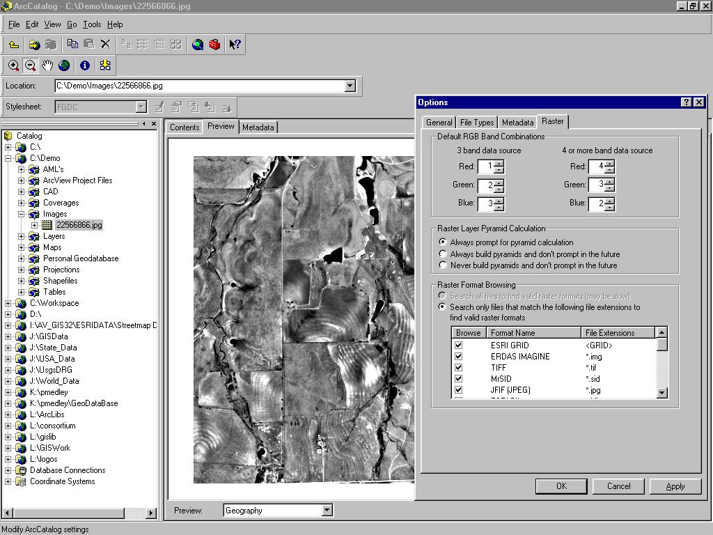
9 Supported Data Types supports four representations of geographic data. Vector data for representing features. Raster data for images, grids, and surfaces. Triangulated irregular networks (TINS) for surfaces. Tabular data. Locators and addresses for finding a geographic position from an address. Locators apply national postal conventions to convert an address to a position.
10 ArcCatalog and Metadata Metadata is primarily viewed and edited in ArcCatalog. ArcCatalog allows metadata to be easily created, stored, and accessed for all data types supported by ArcInfo 8.0 using open, flexible, industry standard technology. AI8 has out-of-the-box support for the federal geographic data committee (FGDC) metadata content standard, ArcCatalog has a built-in and easily accessible fullfeatured metadata editor. AI8 automatically stores metadata with the data so that it also travels when the data is moved, distributed, exported, or renamed, including attached documents.
11 ArcCatalog and Metadata Bottom line: metadata editor is easy to use. Result = more organized and accurate data.
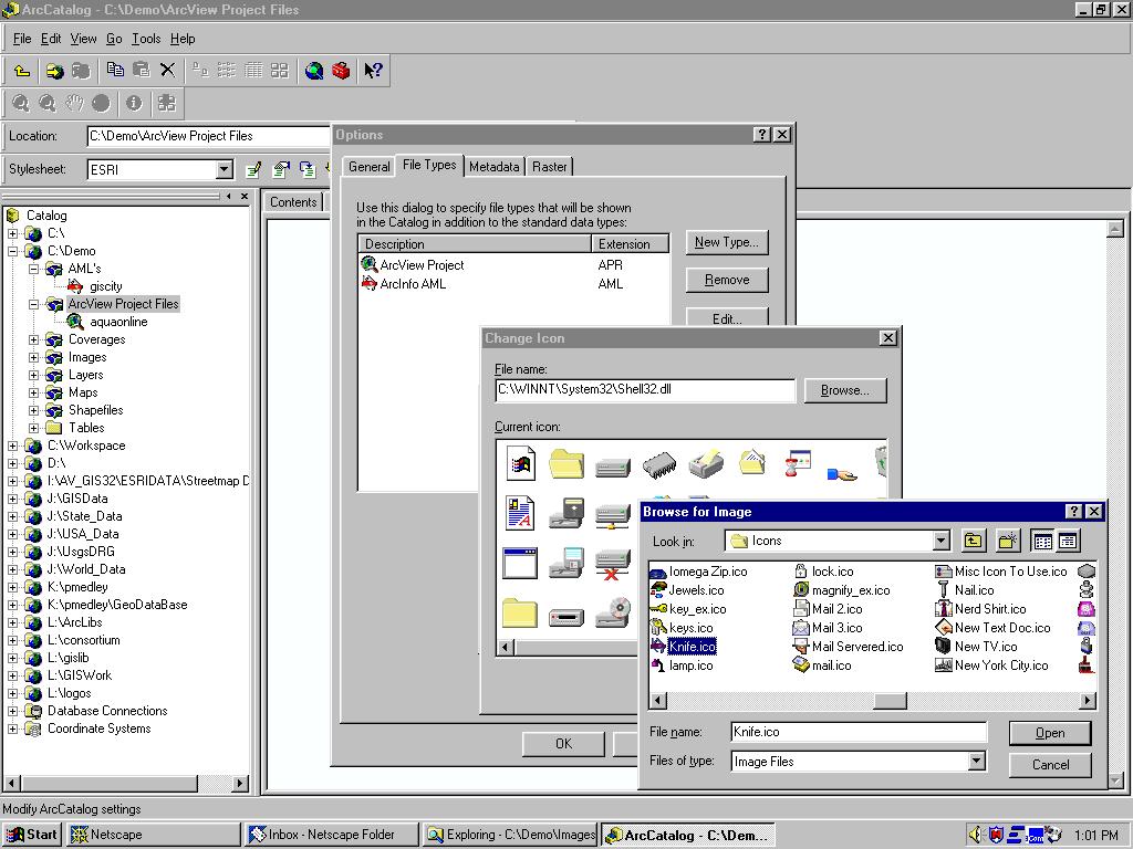
12 Creating and Editing Metadata Choose dataset and click the metadata tab Metadata is automatically created if it doesn t exist This can be turned on/off Some metadata is automatically obtained ( harvested ( from the data You can control frequency of metadata harvesting Automatic time interval Manually Any file type can be added as an attachment to the metadata to extend metadata information

13 ArcCatalog Metadata Editor
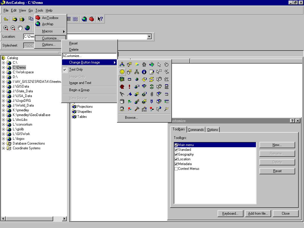
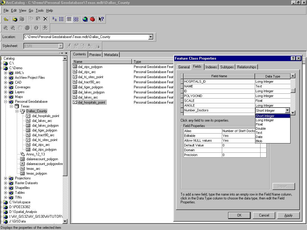
14 ArcCatalog From ArcCatalog you can add and edit the properties of fields in tables, shapefiles and feature classes by right clicking on the object and going to properties.

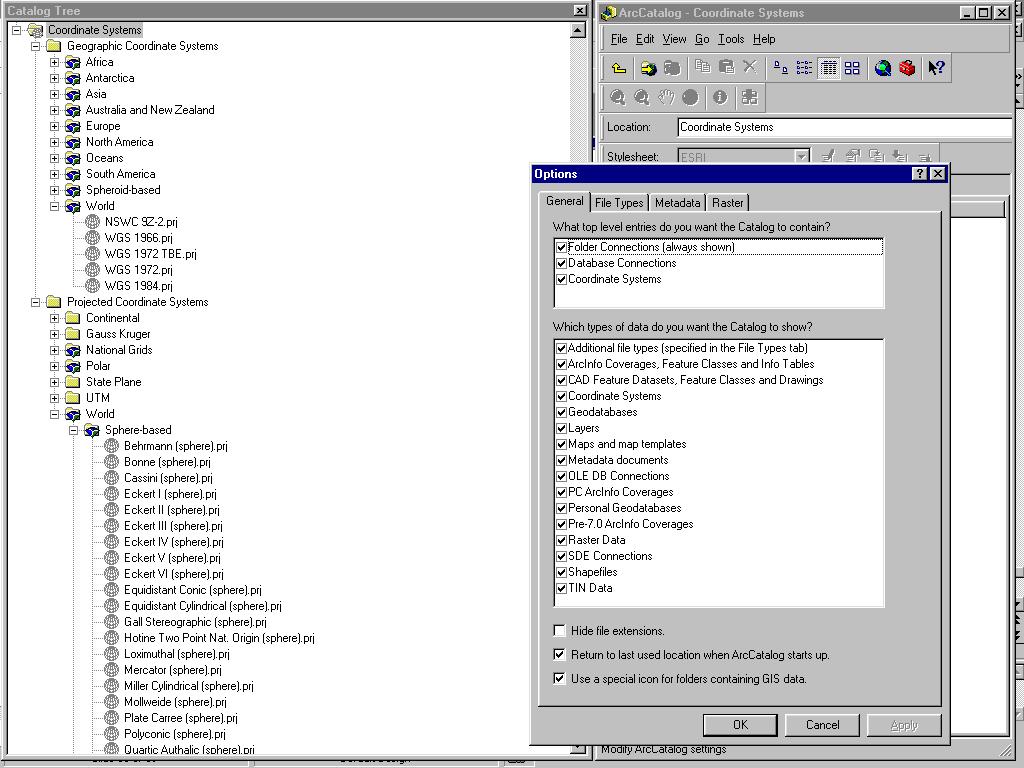
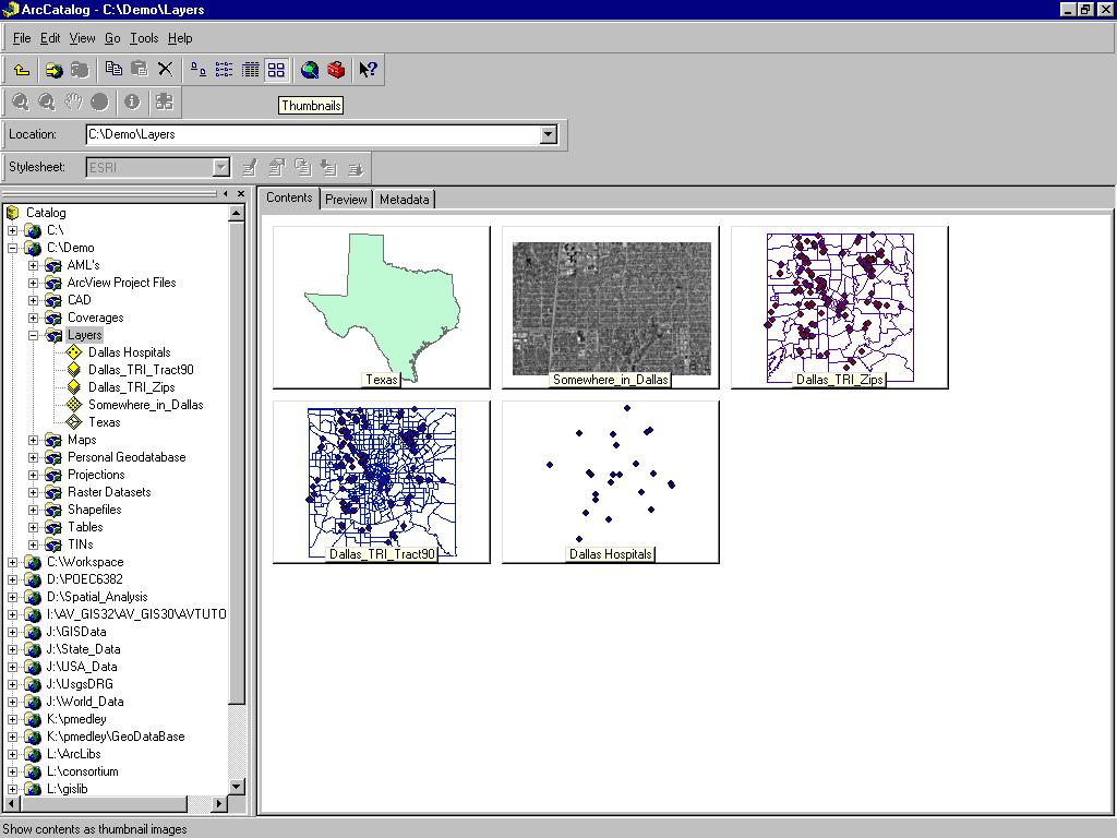
15 Detachable Catalog Tree ESRI Metadata Viewer
 Layers (Bright Yellow) Raster Datasets")
16 Folder Connections CAD Dataset (Blue) CAD Drawing File Coverages (Yellow) Layers (Bright Yellow) Raster Datasets (Grid)
 Shapefiles (Green) Projection (Globe) ArcView Dbase Table (Green)")
17 Personal Geodatabase (Grey) ArcMap Document (.mxd) Shapefiles (Green) Projection (Globe) ArcView Dbase Table (Green) ArcInfo Info Table (Yellow)


18 TIN Dataset Preview Tab

19 Geodatabase Relationship Class Feature Classes Feature Dataset Annotation Class

20 Projection Files.*prj


21

22

23
24
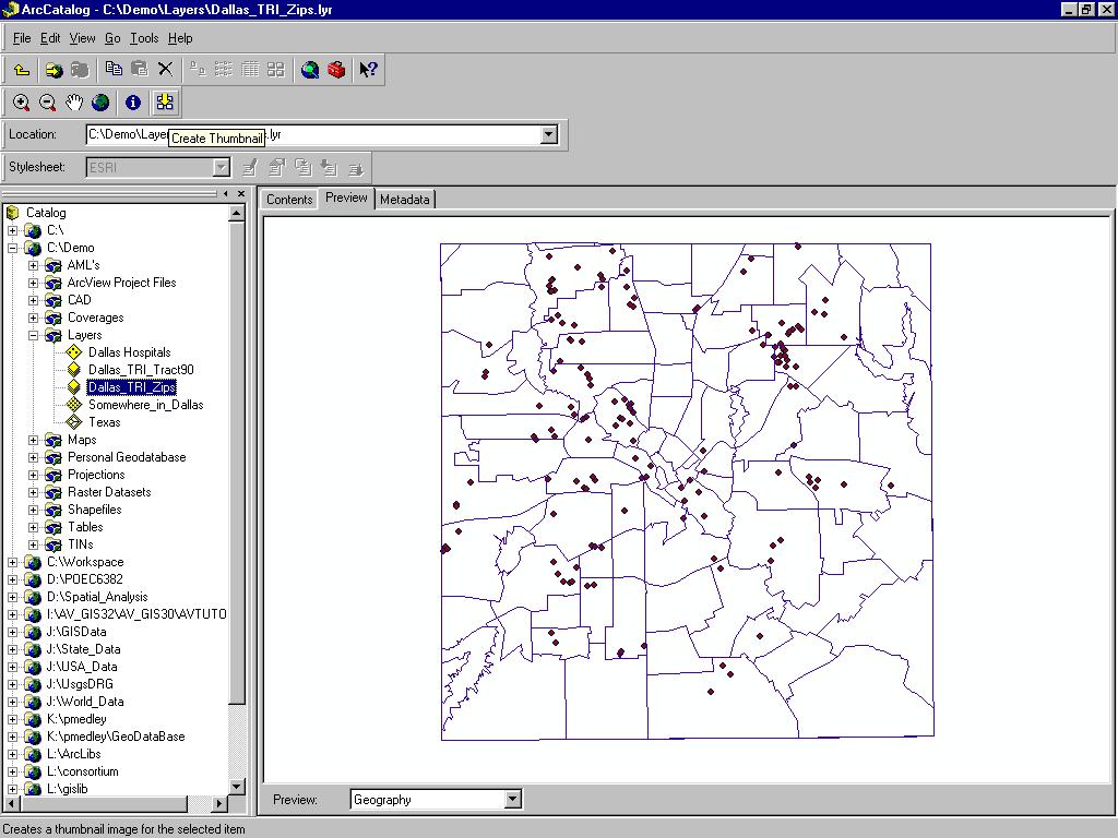
25 Creating Thumbnails

26

27

 Database")
28 Wizards for Creating Database Connections Remote Database Connection (Grey Cylinder w/network) Database Table (Blue)


29

30
31
Introduction to ArcSDE 8. John Calkins
 Introduction to ArcSDE 8 John Calkins Why are you here? Introduction to ArcSDE? What is a GeoDatabase? Existing SDE user? Existing ArcInfo user? Technical details on implementation? Just confused... ArcSDE
ArcMap - EXPLORING THE DATABASE Part I. SPATIAL DATA FORMATS Part II
 Week 5 ArcMap - EXPLORING THE DATABASE Part I SPATIAL DATA FORMATS Part II topics of the week Exploring the Database More on the Table of Contents Exploration tools Identify, Find, Measure, Map tips, Hyperlink,
Esri s ArcGIS Enterprise. Today s Topics. ArcGIS Enterprise. IT4GIS Keith T. Weber, GISP GIS Director ISU GIS Training and Research Center
 Esri s ArcGIS Enterprise IT4GIS Keith T. Weber, GISP GIS Director ISU GIS Training and Research Center Today s Topics Part 1: ArcGIS Enterprise architecture Part 2: Storing and serving data for the enterprise
LAB 1: Introduction to ArcGIS 8
 LAB 1: Introduction to ArcGIS 8 Outline Introduction Purpose Lab Basics o About the Computers o About the software o Additional information Data ArcGIS Applications o Starting ArcGIS o o o Conclusion To
Object modeling and geodatabases. GEOG 419: Advanced GIS
 Object modeling and geodatabases GEOG 419: Advanced GIS CAD Data Model 1960s and 1970s Geographic data stored as points, lines, and areas No attributes; each feature type stored on a different layer No
Using ESRI data in Autodesk ISD Products
 GI13-3 Using ESRI data in Autodesk ISD Products 1.5 hr. Class 02-Dec-03 3:30pm - 5:00pm Session Description: We will focus on using data in a variety of ESRI formats within the Autodesk GIS product line,
Esri s Spatial Database Engine. Today s Topics. ArcSDE. A spatial database engine that works on
 Esri s Spatial Database Engine IT4GIS Keith T. Weber, GISP GIS Director ISU GIS Training and Research Center Today s Topics Part 1: What is ArcSDE? Why use ArcSDE? ArcSDE Data Structure How is data stored
Answer the following general questions: 1. What happens when you right click on an icon on your desktop? When you left double click on an icon?
 Name: Date: June 27th, 2011 GIS Boot Camps For Educators Practical: Explore ArcGIS 10 Desktop Tools and functionality Day_1 Lecture 1 Sources: o ArcGIS Desktop help o ESRI website o Getting to Know ArcGIS
Finding and Using Spatial Data
 Finding and Using Spatial Data Introduction In this lab, you will download two different versions of the National Wetlands Inventory (NWI) dataset for a region of Massachusetts, from a source on the internet.
Map Library ArcView Version 1 02/20/03 Page 1 of 12. ArcView GIS
 Map Library ArcView Version 1 02/20/03 Page 1 of 12 1. Introduction 1 ArcView GIS ArcView is the most popular desktop GIS analysis and map presentation software package.. With ArcView GIS you can create
Key Terms. Attribute join Target table Join table Spatial join
 Key Terms Attribute join Target table Join table Spatial join Lect 10A Building Geodatabase Create a new file geodatabase Map x,y data Convert shape files to geodatabase feature classes Spatial Data Formats
Welcome to NR402 GIS Applications in Natural Resources. This course consists of 9 lessons, including Power point presentations, demonstrations,
 Welcome to NR402 GIS Applications in Natural Resources. This course consists of 9 lessons, including Power point presentations, demonstrations, readings, and hands on GIS lab exercises. Following the last
Synchronization in ArcCatalog
 An ESRI Technical Paper August 2001 ESRI 380 New York St., Redlands, CA 92373-8100, USA TEL 909-793-2853 FAX 909-793-5953 E-MAIL info@esri.com WEB www.esri.com Copyright 2001 ESRI All rights reserved.
ArcGIS 9. Using ArcCatalog
 ArcGIS 9 Using ArcCatalog Copyright 1999, 2003 2004 ESRI All rights reserved. Printed in the United States of America. The information contained in this document is the exclusive property of ESRI. This
Using ArcCatalog. GIS by ESRI
 Using ArcCatalog GIS by ESRI Copyright 1999, 2001 ESRI All rights reserved Printed in the United States of America The information contained in this document is the exclusive property of ESRI This work
Exercise 1: An Overview of ArcMap and ArcCatalog
 Exercise 1: An Overview of ArcMap and ArcCatalog Introduction: ArcGIS is an integrated collection of GIS software products for building a complete GIS. ArcGIS enables users to deploy GIS functionality
Extracting Inventory History Information from the Land & Resource Data Warehouse (LRDW)
") Extracting Inventory History Information from the Land & Resource Data Warehouse (LRDW) The following instructions will illustrate how to extract inventory history information from the Land & Resource
Extracting Inventory History Information from the Land & Resource Data Warehouse (LRDW) The following instructions will illustrate how to extract inventory history information from the Land & Resource
Using the Geodatabase
 Using the Geodatabase February 13, 2002 Presented by: John Stroud, ESRI GeoDatabase Geodatabase comes in two flavors Personal mdb format ArcSDE rdbms format ArcGIS is a suite of three products ArcView,
ArcGIS 9. Using ArcCatalog
 ArcGIS 9 Using ArcCatalog Copyright 1999, 2003 2005 ESRI All rights reserved. Printed in the United States of America. The information contained in this document is the exclusive property of ESRI. This
Extracting RESULTs Information from the Land & Resource Data Warehouse (LRDW)
") Extracting RESULTs Information from the Land & Resource Data Warehouse (LRDW) The following instructions will illustrate how to extract inventory Results information from the Land & Resource data Warehouse
Extracting RESULTs Information from the Land & Resource Data Warehouse (LRDW) The following instructions will illustrate how to extract inventory Results information from the Land & Resource data Warehouse
Exercise 1: Getting to know ArcGIS
 The Scenario You are working for the California Visitor s Commission. You have been asked to prepare a map of California for several dignitaries from out of the country. Your map will need to include enough
A Second Look at DEM s
 A Second Look at DEM s Overview Detailed topographic data is available for the U.S. from several sources and in several formats. Perhaps the most readily available and easy to use is the National Elevation
Lab.4 & Assignment 2. Lab4. Conversion of Hardcopy Map to ArcGIS Map
 EATS4400 GIS Lab.4 & Assignment 2 Lab4 Conversion of Hardcopy Map to ArcGIS Map In this lab exercise you will have chance to go through the steps to convert hardcopy map into digital map for ArcGIS. Digitizing
Store and Manage Data in a DBMS With ArcView Database Access. Presented By: Andrew Arana & Canserina Kurnia
 Store and Manage Data in a DBMS With ArcView Database Access Presented By: Andrew Arana & Canserina Kurnia Overview Topics to be Covered: General method for accessing data database themes, database tables
What's New in ArcGIS 9.2 Service Packs
 What's New in ArcGIS 9.2 Service Packs 8 July 2008 Updated for Service Pack 6 This document describes the main enhancements to 9.2 added by the service packs. It does not cover the bug fixes and quality
دورة تدريبية عن تطبيقات برنامج ARC GIS
 دورة تدريبية عن تطبيقات برنامج ARC GIS مايو 2009 دورة تدريبيت عن تطبيقاث برنامج ARC GIS 2009 مايو Table of Contents Introduction... viii Module 1: Introduction to ArcGIS 9 Module Objectives... 1-1 ArcGIS
ArcCatalog or the ArcCatalog tab in ArcMap ArcCatalog or the ArcCatalog tab in ArcMap ArcCatalog or the ArcCatalog tab in ArcMap
 ArcGIS Procedures NUMBER OPERATION APPLICATION: TOOLBAR 1 Import interchange file to coverage 2 Create a new 3 Create a new feature dataset 4 Import Rasters into a 5 Import tables into a PROCEDURE Coverage
Introduction to ArcGIS I
 Introduction 1-1 What is ArcGIS? ArcGIS Clients ArcReader E X T E N S I O N S ArcGIS Desktop ArcView ArcEditor ArcInfo ArcGIS Engine ArcPad Custom Application E X T E N S I O N S Web Browser Components
COPYRIGHTED MATERIAL. Introduction to 3D Data: Modeling with ArcGIS 3D Analyst and Google Earth CHAPTER 1
 CHAPTER 1 Introduction to 3D Data: Modeling with ArcGIS 3D Analyst and Google Earth Introduction to 3D Data is a self - study tutorial workbook that teaches you how to create data and maps with ESRI s
Creating and Editing a New Shapefile
 Creating and Editing a New Shapefile Written by Barbara Parmenter, revised October, 0 CREATING AND EDITING A NEW SHAPEFILE... CREATING THE GEOGRAPHIC FEATURE (POINT, LINE, OR POLYGON)... CREATING THE ATTRIBUTE
Introduction to Geodatabase and Spatial Management in ArcGIS. Craig Gillgrass Esri
 Introduction to Geodatabase and Spatial Management in ArcGIS Craig Gillgrass Esri Session Path The Geodatabase - What is it? - Why use it? - What types are there? - What can I do with it? Query Layers
Metadata Requirements for SanGIS Data Layers
 Metadata Requirements for SanGIS Data Layers What is Metadata? Metadata is data about data. It is information in addition to the spatial and tabular data that is required to make the data useful. Metadata
ArcGIS for Server Michele Lundeen
 ArcGIS for Server 10.1 Michele Lundeen Summary Vision Installation and Configuration Architecture Publishing Functional Enhancements Cloud Migration and Best Practices Powerful GIS capabilities Delivered
Annotation/Labeling Workshop. Tim Rankin Pat Dolan
 Annotation/Labeling Workshop Tim Rankin Pat Dolan Agenda 8:00am - Introductions 8:05am - Goals of the Workshop 8:15am Labeling 8:45am Annotation Part I 9:15am Break 9:25am Annotation Part II 9:50am Questions
ArcSDE architecture and connections
 ArcSDE architecture and connections Lesson overview ArcSDE system components Application Server Connections Direct Connect Geodatabase properties ArcSDE versions What is a version ArcIMS and versions 6-2
ESRI China (Hong Kong) Limited
 Limited") Setting Proper Windows XP Environment for Displaying Spatial Data with Traditional Chinese Article ID : 100007 Software : ArcGIS Desktop 9.x Platform : Windows XP Home, Windows XP Professional Date : September
Setting Proper Windows XP Environment for Displaying Spatial Data with Traditional Chinese Article ID : 100007 Software : ArcGIS Desktop 9.x Platform : Windows XP Home, Windows XP Professional Date : September
LSGI 521: Principles of GIS. Lecture 5: Spatial Data Management in GIS. Dr. Bo Wu
 Lecture 5: Spatial Data Management in GIS Dr. Bo Wu lsbowu@polyu.edu.hk Department of Land Surveying & Geo-Informatics The Hong Kong Polytechnic University Contents 1. Learning outcomes 2. From files to
Introduction to Geographic Information Systems Spring 2016
 Introduction to Geographic Information Systems Spring 2016 Exercise 2 Introduction to ArcGIS 10 Projects This exercise will introduce you to the common set-up functions of the ESRI ArcGIS software package.
Oracle Spatial A Unifying Framework at the Utah Department Of Transportation
 Oracle Spatial A Unifying Framework at the Utah Department Of Transportation Dan Paske Utah Department of Transportation Oracle DBA Jeff Saunders Farallon Geographics, Inc. Senior Geodatabase Developer
Exporting from GIS 9.0 to AutoCAD
 Exporting from GIS 9.0 to AutoCAD Once a map file is created in GIS with all the desired layers, selected data within a pre-defined boundary can be exported as a AutoCAD.dwg file. Setting up clip boundary
What's New in ArcGIS 9.2 Service Packs
 What's New in ArcGIS 9.2 Service Packs 18 July 2007 Updated for Service Pack 3 This document describes the main enhancements to 9.2 added by the service packs. It does not cover the bug fixes and quality
Name: Date: June 27th, 2011 GIS Boot Camps For Educators Lecture_3
 Name: Date: June 27th, 2011 GIS Boot Camps For Educators Lecture_3 Practical: Creating and Editing Shapefiles Using Straight, AutoComplete and Cut Polygon Tools Use ArcCatalog to copy data files from:
ESRI stylesheet selects a subset of the entire body of the metadata and presents it as if it was in a tabbed dialog.
 Creating Metadata using ArcCatalog (ACT) 1. Choosing a metadata editor in ArcCatalog ArcCatalog comes with FGDC metadata editor, which create FGDC-compliant documentation. Metadata in ArcCatalog stored
The names of other companies and products herein are trademarks or registered trademarks of their respective trademark owners.
 ArcGIS 9 ArcGIS Network Analyst Tutorial G08807_U-AGIS-3DA_tp_94692.ind 1 3/11/04, 10:24 AM Copyright 2005 ESRI. All rights reserved. Printed in the United States of America. The information contained
ArcGIS Server: publishing geospatial data to the web using the EEA infrastructure
 ArcGIS Server: publishing geospatial data to the web using the EEA infrastructure *IMPORTANT: Map Services should be published using the EEA Map Services Tick Sheet for guidance. Contact Sebastien Petit
Compilation of GIS data for the Lower Brazos River basin
 Compilation of GIS data for the Lower Brazos River basin Prepared by Francisco Olivera, Ph.D., P.E., Srikanth Koka, and Lauren Walker Department of Civil Engineering October 2, 2006 Contents: Brief Overview
Integrating ArcGIS to Enterprise Oracle Spatial Using Direct Connect
 Integrating ArcGIS to Enterprise Oracle Spatial Using Direct Connect Michael D. Tsengouras Principal Software Engineer Navigation Technologies Corporation Abstract: Many organizations are adopting Enterprise
Introduction to ArcGIS Server 10.1
 Introduction to ArcGIS Server 10.1 E-Learning for the GIS Professional Any Time, Any Place! geospatialtraining.com Module Outline What is ArcGIS Server? GIS Resources and Services ArcGIS Server Components
A Hands-on Experience with Arc/Info 8 Desktop
 Demo of Arc/Info 8 Desktop page 1 of 17 A Hands-on Experience with Arc/Info 8 Desktop Prepared by Xun Shi and Ted Quinby Geography 377 December 2000 In this DEMO, we introduce a brand new edition of ArcInfo,
hereby recognizes that Timotej Verbovsek has successfully completed the web course 3D Analysis of Surfaces and Features Using ArcGIS 10
 3D Analysis of Surfaces and Features Using ArcGIS 10 Completed on September 5, 2012 3D Visualization Techniques Using ArcGIS 10 Completed on November 19, 2011 Basics of Map Projections (for ArcGIS 10)
An Example of Regional Web Resources: Massachusetts, USA Digital Data
 An Example of Regional Web Resources: Massachusetts, USA Digital Data Author Attribution Major contributors to this curriculum include (alphabetical): Maria Fernandez Michael Hamel Quentin Lewis Maili
Review of File Management and Introduction to ArcGIS
 Review of File Management and Introduction to ArcGIS RNR/GEOG 417/517 Overview of Presentation Discuss the objectives of the lab exercise Introduce the class directory structure General file policies Introduce
How to Authorise ArcGIS for Desktop 10.2 Single Use
 Welcome to ArcGIS How to Authorise ArcGIS for Desktop 10.2 Single Use This document will help you authorise your Desktop product and any extensions you have purchased for Single Use. You can perform this
Size: Small Medium X Large
 Field Operations Guide By: Elise Fisher Organization: EF Geographic. L.C. Response Time Analysis Brief Explanation: Uses GIS to assess expected response times from each of their existing public safety
SPATIAL DATA MODELS Introduction to GIS Winter 2015
 SPATIAL DATA MODELS Introduction to GIS Winter 2015 GIS Data Organization The basics Data can be organized in a variety of ways Spatial location, content (attributes), frequency of use Come up with a system
Create a personal geodatabase
 Create a personal geodatabase To create a personal geodatabase that corresponds to the same release as the ArcGIS for Desktop client you are using, follow these steps: 1. In ArcCatalog, right-click the
Working with Events in ArcGIS 8.2
 Working with Events in ArcGIS 8.2 This tutorial is a companion to the article, Understanding Dynamic Segmentation: Working with Events in ArcGIS in the October December 2002 issue of ArcUser magazine.
Mapping 2001 Census Data Using ArcView 3.3
 Mapping 2001 Census Data Using ArcView 3.3 These procedures outline: 1. Mapping a theme (making a map) 2. Preparing the layout for printing and exporting the map into various file formats. In order to
Using ArcGIS. Tracking Analyst. GIS by ESRI
 Using ArcGIS Tracking Analyst GIS by ESRI Copyright 2002 ESRI All Rights Reserved Printed in the United States of America The information contained in this document is the exclusive property of ESRI This
ArcGIS 9. Using ArcGIS Tracking Analyst
 ArcGIS 9 Using ArcGIS Tracking Analyst Copyright (c) 2004-2005 TASC, Inc. and its licensor(s). All Rights Reserved. Printed in the United States of America. The information contained in this document is
Digging Into Autodesk Map 3D 2007 Level 1 Training Rick Ellis Michael Carris Russell Martin
 Digging Into Autodesk Map 3D 2007 Level 1 Training Rick Ellis Michael Carris Russell Martin PO Box 344 Canby Oregon 97013 www.cadapult-software.com training@cadapult-software.com (503) 829-8929 Table of
TABLES, ANATOMY OF A TABLE
 week 6 TABLES, ANATOMY OF A TABLE topics of the week Table structure Working with tables Table relationships Cardinality, Joins and Relates Table Jargon What is a Database? What is a Table? What is a Record/Row?
Getting Started With LP360
 Getting Started With LP360 12/22/2015 1 Contents What is LP360?... 3 System Requirements... 3 Installing LP360... 4 How to Enable the LP360 Extension... 4 How to Display the LP360 Toolbar... 4 How to Import
Combine Yield Data From Combine to Contour Map Ag Leader
 Combine Yield Data From Combine to Contour Map Ag Leader Exporting the Yield Data Using SMS Program 1. Data format On Hard Drive. 2. Start program SMS Basic. a. In the File menu choose Open. b. Click on
Data Interoperability Extension Tutorial
 Data Interoperability Extension Tutorial Copyright 1995-2012 Esri All rights reserved. Table of Contents About the Data Interoperability extension tutorial...................... 3 Exercise 1: Using direct-read
Geographical Information Systems Institute. Center for Geographic Analysis, Harvard University. LAB EXERCISE 1: Basic Mapping in ArcMap
 Harvard University Introduction to ArcMap Geographical Information Systems Institute Center for Geographic Analysis, Harvard University LAB EXERCISE 1: Basic Mapping in ArcMap Individual files (lab instructions,
Lesson 8 : How to Create a Distance from a Water Layer
 Created By: Lane Carter Advisor: Paul Evangelista Date: July 2011 Software: ArcGIS 10 Lesson 8 : How to Create a Distance from a Water Layer Background This tutorial will cover the basic processes involved
GIS LAB 8. Raster Data Applications Watershed Delineation
 GIS LAB 8 Raster Data Applications Watershed Delineation This lab will require you to further your familiarity with raster data structures and the Spatial Analyst. The data for this lab are drawn from
GIS Workbook #1. GIS Basics and the ArcGIS Environment. Helen Goodchild
 GIS Basics and the ArcGIS Environment Helen Goodchild Overview of Geographic Information Systems Geographical Information Systems (GIS) are used to display, manipulate and analyse spatial data (data that
Objective: To be come more familiar with some more advanced applications in ArcGIS.
 Advanced Procedures in ArcGIS 2005 SPACE Workshop OSU Author: Jason VanHorn Purpose: Having gone through Getting to know ArcGIS, you are now ready to do some more advanced applications. In this lab you
Lab 1: Exploring data format
 Geog 458: Map Sources and Errors January 13, 2006 Lab 1: Exploring data format Data format supported by ArcGIS There are many file types supported by ArcGIS, in addition to specific cartographic objects.
This document explains how to connect to a SQL Server database using ESRI ArcCatalog in order to extract data containing spatial coordinates.
 Arctic Network Arctic Network Data Management Standard Operating Procedure Inventory & Monitoring Program U.S. Department of the Interior Data Management Standard Operating Procedure NPS/ARCN/DMSOP-2009-07
Working with Metadata in ArcGIS
 Esri International User Conference San Diego, California Technical Workshops July 26, 2012 Working with Metadata in ArcGIS Aleta Vienneau Metadata in ArcGIS ArcGIS metadata goals Editing metadata Setting
THE HONG KONG POLYTECHNIC UNIVERSITY DEPARTMENT OF LAND SURVEYING & GEO-INFORMATICS LSGI521 PRINCIPLES OF GIS
 THE HONG KONG POLYTECHNIC UNIVERSITY DEPARTMENT OF LAND SURVEYING & GEO-INFORMATICS LSGI521 PRINCIPLES OF GIS Student name: Student ID: Table of Content Working with files, folders, various software and
Linear Referencing in ArcGIS : Practical Considerations for the Development of an Enterprisewide GIS
 Linear Referencing in ArcGIS : Practical Considerations for the Development of an Enterprisewide GIS An ESRI Technical Paper April 2003 ESRI 380 New York St., Redlands, CA 92373-8100, USA TEL 909-793-2853
Attribute data management
 LA561 Computer Applications in LA (GIS) Attribute data management Dr. Ragab Khalil Department of Landscape Architecture Faculty of Environmental Design King AbdulAziz University Room 103 Overview Using
The Oracle Enterprise Geodatabase (EGDB) Charlie Crocker Farallon Geographics, Inc.
 Charlie Crocker Farallon Geographics, Inc.") The Oracle Enterprise Geodatabase (EGDB) Charlie Crocker Farallon Geographics, Inc. www.fargeo.com Norcal URISA Chapter Meeting 2/9/2005 Todays Goals Enterprise geodatabase defined Roles Oracle can play
The Oracle Enterprise Geodatabase (EGDB) Charlie Crocker Farallon Geographics, Inc. www.fargeo.com Norcal URISA Chapter Meeting 2/9/2005 Todays Goals Enterprise geodatabase defined Roles Oracle can play
How to Create a Tile Package
 United States Department of Agriculture Digital Mobile Sketch Mapping (DMSM) How to Create a Tile Package (TPK) Forest Service Introduction A tile package (.tpk) allows you to use a set of packaged tiles
Healthy Estuaries 2020: Towards Addressing Coastal Squeeze in Estuaries Appendix B: Technical User Guide
 Healthy Estuaries 2020: Towards Addressing Coastal Squeeze in Estuaries Appendix B: Technical User Guide HASKONINGDHV UK LIMITED RIVERS, DELTAS & COASTS Rightwell House Bretton Peterborough PE3 8DW United
Your Prioritized List. Priority 1 Faulted gridding and contouring. Priority 2 Geoprocessing. Priority 3 Raster format
 Your Prioritized List Priority 1 Faulted gridding and contouring Priority 2 Geoprocessing Priority 3 Raster format Priority 4 Raster Catalogs and SDE Priority 5 Expanded 3D Functionality Priority 1 Faulted
Introduction to GIS 2011
 Introduction to GIS 2011 Digital Elevation Models CREATING A TIN SURFACE FROM CONTOUR LINES 1. Start ArcCatalog from either Desktop or Start Menu. 2. In ArcCatalog, create a new folder dem under your c:\introgis_2011
ArcGIS 9. ArcGIS Tracking Analyst Tutorial
 ArcGIS 9 ArcGIS Tracking Analyst Tutorial Copyright (c) 2004 2008 ESRI. All Rights Reserved. Printed in the United States of America. The information contained in this document is the exclusive property
Editing Versioned Geodatabases : An Introduction
 Esri International User Conference San Diego, California Technical Workshops July 24, 2012 Editing Versioned Geodatabases : An Introduction Cheryl Cleghorn Shawn Thorne Assumptions: Basic knowledge of
Spatial Manager- version 4.0 User Guide
 Exor Corporation Limited Spatial Manager- version 4.0 User Guide The Global Leader in Infrastructure Asset Management Copyright Exor Corporation Ltd, England, 2006 All rights reserved 1 This page intentionally
v TUFLOW-2D Hydrodynamics SMS Tutorials Time minutes Prerequisites Overview Tutorial
 v. 12.2 SMS 12.2 Tutorial TUFLOW-2D Hydrodynamics Objectives This tutorial describes the generation of a TUFLOW project using the SMS interface. This project utilizes only the two dimensional flow calculation
Linear Referencing in ArcGIS. GIS by ESRI
 Linear Referencing in ArcGIS GIS by ESRI Copyright 00 ESRI All rights reserved. Printed in the United States of America. The information contained in this document is the exclusive property of ESRI. This
ArcGIS Pro Terminology Guide
 ArcGIS Pro Terminology Guide Essential Terminology or Functionality That s New to ArcGIS Pro ArcGIS Pro Project Map Scene Ribbon Tab on the ribbon View Active view Pane Gallery Task Quick Access Toolbar
ArcGIS Pro Terminology Guide
 ArcGIS Pro Terminology Guide Sharing Terminology and User Interface Cross-Reference Share content Project package (.ppkx) Map package (.mpkx) Layer package (.lpkx) Share or publish a web layer Share Web
Unpacking Instructions
 DNR Data Deli II Unpacking and User Instructions May 2004 Now that you ve successfully downloaded a bundle of GIS data from the Minnesota Dept. of Natural Resources, GIS Data Deli II there are a couple
Understanding ArcSDE. GIS by ESRI
 Understanding ArcSDE GIS by ESRI Copyright 1999, 2001 2002 ESRI All rights reserved Printed in the United States of America The information contained in this document is the exclusive property of ESRI
Using ArcGIS. Tracking Analyst. GIS by ESRI
 Using ArcGIS Tracking Analyst GIS by ESRI Copyright (c) 2002 TASC, Inc. and its licensor(s). All Rights Reserved. Printed in the United States of America. The information contained in this document is
Lab 18c: Spatial Analysis III: Clip a raster file using a Polygon Shapefile
 Environmental GIS Prepared by Dr. Zhi Wang, CSUF EES Department Lab 18c: Spatial Analysis III: Clip a raster file using a Polygon Shapefile These instructions enable you to clip a raster layer in ArcMap
Making Yield Contour Maps Using John Deere Data
 Making Yield Contour Maps Using John Deere Data Exporting the Yield Data Using JDOffice 1. Data Format On Hard Drive 2. Start program JD Office. a. From the PC Card menu on the left of the screen choose
Feature Enhancements by Release
 Autodesk Map Feature Enhancements by Release This document highlights the feature enhancements that have occurred with each release of Autodesk Map software from Release 4 (2000i) through the current 2004
Geodatabases. Dr. Zhang SPRING 2016 GISC /03/2016
 Geodatabases Dr. Zhang SPRING 2016 GISC 1401 10/03/2016 Using and making maps Navigating GIS maps Map design Working with spatial data Spatial data infrastructure Interactive maps Map Animations Map layouts
This support note will discuss several methods of creating no spray zones for Sentinel GIS>
 Reason Sentinel Adulticiding support a polygon no spray layer. Adulticiding mobile software warns the driver when they are approaching a no spray zone so they can turn off the sprayer. Because no spray
ArcGIS Network Analyst and Network Dataset. Jim McKinney ESRI
 ArcGIS Network Analyst and Network Dataset Jim McKinney ESRI ArcGIS Network Analyst Everything in ArcView GIS 3x and more Routing Directions Network Analysis Tight Integration with Geoprocessing Models
Introduction to ArcGIS Desktop
 Introduction to ArcGIS Desktop Prepared by David R. Maidment Center for Research in Water Resources University of Texas at Austin September 2011 Contents Goals of the Exercise Computer and Data Requirements
FHWA GIS Safe Bike Routes Tools Version 4.0. User Guide
 FHWA GIS Safe Bike Routes Tools Version 4.0 User Guide Prepared for Federal Highway Administration Office of Safety Research and Development 6300 Georgetown Pike, T-203 McLean, VA 22101-2296 By 101 Walnut
Architectural Level of Study of ArcGIS Server
 Architectural Level of Study of ArcGIS Server Annie Vinuthna D, II year M.Tech, Computer Science & Engineering Department, P.J.R.Shalem Raju, Senior Assistant Professor, Computer Science & Engineering