Working with Scientific Data in ArcGIS Platform
|
|
|
- Lucinda Lang
- 5 years ago
- Views:
Transcription
1 Working with Scientific Data in ArcGIS Platform Sudhir Raj Shrestha Hong Xu Esri User Conference, San Diego, CA. July 11, 2017


2 What we will cover today Scientific Multidimensional data Ingesting Using Scientific Data in ArcGIS Ingesting and Managing Sharing Managing Visualizing and Analyzing Disseminating and Consuming Scientific Computing ArcGIS is an Open Platform Application(s) and Use case Visualizing Analyzing
3 Scientific Multidimensional Data


4 Diverse Scientific Multidimensional Data Oceanographic Salinity Sea Temperature Ocean current Meteorological Temperature Water Vapor/Precipitation Wind speed/direction Terrestrial Soil moisture NDVI Land cover

5 Challenges Manage Analyze Share variety of formats volume & velocity redundancy portability scalability reproducibility integration standards accessibility
6 Ingesting and Managing Data
7 Multidimensional Mosaic Dataset mosaic mosaic dataset table HDF GRIB netcdf d-aware rasters spatially-indexed catalog multi-resolution, multivariate, multidimensional reduce storage redundancy & pixel resampling defines information products on-demand processing raster pixels Representing multivariate collection of multidimensional rasters in ArcGIS


8 ArcGIS Multidimensional Data Model Multidimensional Mosaic Dataset in Geodatabase Ingest variables from netcdf, HDF & GRIB using raster types - Aggregate multiple variables, multiple files Support on-the-fly processing
9 Raster Types for Multidimensional data data on disk raster type mosaic dataset netcdf HDF GRIB d-aware rasters crawls disk identifies rasters extracts metadata attaches processing stores no pixels references rasters stores processing & metadata Format-agnostic direct ingestion of rasters into a mosaic dataset


10 Creating a Multidimensional Mosaic Dataset Using Geoprocessing Tools Create a empty mosaic dataset Add select variables
11 Visualizing and Analyzing


12 Slicing your data Slicing By variable, using variable selector By dimension using Select by Dimension Geoprocessing tool Visualizing Time slider Range slider Vector field renderer
13 Raster Analysis Geoprocessing Tools (GP) Tons of GP tools GP tools, Python scripting and ModelBuilder perfect automation of data management and analysis. Dynamic On-the-Fly Processing using Raster Functions Manage and analyze large collection of rasters on the fly as the data is accessed and viewed Quick and save time by not required to write the processed product to disk Functions can be applied to various rasters (images) including: Raster dataset layers Mosaic datasets Image service layers
14 Raster Function: Transforming Raster Data raster function raster-valued transformation piecewise, scale-aware local / focal on-demand processing unary, binary,, n-ary, polyadic Learn more at: github.com/esri/raster-functions Choose from dozens of built-in functions or implement your own algorithm using Python


15 Chaining Raster Functions Elevation Slope Conservation area Soil Type Soil Acidity to compose a complex analytic model

16 Raster Function Templates raster variables A portable & reusable chain of raster functions

 Field defines")
17 Raster Function Template and MD: GroupName and Tag Mosaic Data must contain: Field stored with variable names (tag) Field defines groups(groupname)
18 Applying a Raster Function Template to Mosaic Dataset Processing by group Apply RFT to Mosaic Dataset: Process each row Process each group
19 Disseminating and Consuming
20 Disseminating Desktop Web Device Apps professional geospatial analysts Access / Identity multivariate multidimensional mosaic dataset Services Server Online Content and Services

21 Serving Multidimensional Data Multidimensional Image Services Serve data (not a picture) LERC compression to maintain data quality Perform analysis and analysis through the web Multiple clients: Desktop clients Web Map Viewers JavaScript etc. WMS/WCS Time=t1&Elevation=z1 DIM_Time=t1&DIM_depth
22 Sharing data & information products Mosaic Dataset Share As Web Layer Enable access to a dynamic representation of your information product as an image service
23 Consuming your services In any ArcGIS application or any WMS client In a web map Identify web services driven by maps or datasets Bring service layers into a web map In a map-based application Configurable apps Story Maps Web AppBuilder Custom web apps using ArcGIS API for JavaScript
24 Demo Scientific data support in ArcGIS
25 ArcGIS: An Open Platform

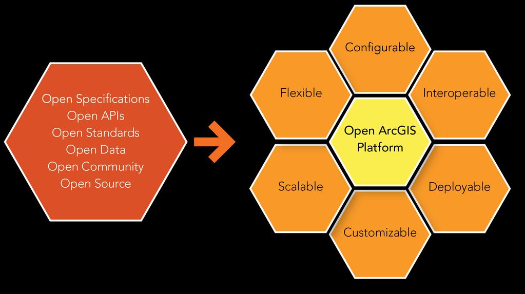

26 ArcGIS is an Open Platform
27 Scientific Data Interoperability in ArcGIS Ingesting many scientific data formats Supporting common scripting language in scientific computing Support OGC specifications in serving scientific data through web Ingesting Serving Computing
28 Scientific Data Formats Support multidimensional raster formats NetCDF GRIB 1 and GRIB 2 HDF 4 and HDF 5 Use Open Source GDAL Extendable by developing custom format driver
29 Scientific Data Formats - HDF HDF4 Support HDFEOS4 HDF5 Support HDFEOS5 (for HDF5) Support some custom CF style HDF5 SMAP Will provide generic support for CF style HDF5
30 Scientific Computing Perform scientific computing using Geoprocessing tool Extendable by creating a custom Geoprocessing tool Performing scientific computing using Raster Function Extendable by developing a custom python raster function Support Python Scripting NumPy SciPy
31 Serving Scientific Data Serve gridded raster data as image service with OGC capabilities WCS WMS Dimensional query of Time and Depth
32 Few Take Away 1. Mosaic Dataset is a robust data model that allows you to manage your large collections of scientific multidimensional data 2. Raster function(s) can help with your efficient on the fly computing that saves Time and Resources 3. Mosaic Dataset is a quick way to build the live web service 4. Make your scientific data and research output usable with repeatable workflow to your larger community 5. ArcGIS is an open platform that provides opportunity to expand the capabilities to collaborate and support your work
 When: July 12,")
 When: July 12, 2017 2:00-3.")
33 Want to learn more.please join these sessions: Scientific and Multidimensional Raster Support in ArcGIS (SDCC Room 17A) When: July 12, :00-10:00 AM. Raster Analytics-Envision Center Presentation (SDCC: Envision Center 1) When: July 12, : PM Image Management using Mosaic Datasets and Image Services (Room 3). When: July 13, :30-9:45 AM Session 2084: Weather, Forecasting, and Radar Site-selection (Room 29 A/B) When: July 13, :00AM-12PM.


34 Please Take Our Survey on the Esri Events App! Download the Esri Events app and find your event Select the session you attended Scroll down to find the survey Complete Answers and Select Submit


35
Scientific and Multidimensional Raster Support in ArcGIS
 Scientific and Multidimensional Raster Support in ArcGIS Sudhir Raj Shrestha sshrestha@esri.com Brief breakdown Scientific Multidimensional data Ingesting Scientific MultiDim Data in ArcGIS Ingesting and
Scientific Data Plat f or m
 Usi n g Ar cgis as a Scientific Data Plat f or m Feroz Kadar Sudhir Raj Shrestha Top i cs Introduction Ingesting and managing Visualizing and analyzing Disseminating and consuming The road ahead Scientific
Python: Working with Multidimensional Scientific Data. Nawajish Noman Deng Ding
 Python: Working with Multidimensional Scientific Data Nawajish Noman Deng Ding Outline Scientific Multidimensional Data Ingest and Data Management Analysis and Visualization Extending Analytical Capabilities
Getting Started with the JS API for Multidimensional Image Services. Hong Xu, Wenxue Ju
 Getting Started with the JS API for Multidimensional Image Services Hong Xu, Wenxue Ju Outline How to publish a multidimensional image service - ArcGIS multidimensional data model JS API for multidimensional
Integrating Imagery into ArcGIS Runtime Application. Jie Zhang, Zhiguang Han San Jacinto, 5:30 pm 6:30 pm
 Integrating Imagery into ArcGIS Runtime Application Jie Zhang, Zhiguang Han San Jacinto, 5:30 pm 6:30 pm Overviews Imagery is an essential component of ArcGIS - Visualization, Processing and Analysis -
Making the Most of Raster Analysis with Living Atlas Data. Aileen Buckley, PhD, Research Cartographer Esri - Redlands
 Making the Most of Raster Analysis with Living Atlas Data Aileen Buckley, PhD, Research Cartographer Esri - Redlands Spatial Analysis with Online Data Your Desktop Web Device Never scrounge for or download
ArcGIS Workflows for Optimizing Image Management & Services in the Cloud. Cody A. Benkelman
 ArcGIS Workflows for Optimizing Image Management & Services in the Cloud Cody A. Benkelman Outline Mosaic Datasets Automation with the Mosaic Dataset Configuration Script (MDCS) OptimizeRasters Lower level
Publishing image services in ArcGIS
 Esri International User Conference San Diego, California Technical Workshops July 26, 2012 Publishing image services in ArcGIS Wenxue Ju & Melanie Harlow What is an image service? A way to make image and
Serving Imagery with ArcGIS Server 10.1
 Serving Imagery with ArcGIS Server 10.1 Presented by: André Piasta apiasta@esri.ca Esri Canada Users Conference Calgary, AB 28 May 2013 Today s Agenda ArcGIS server and image services Publishing of imagery
Managing Imagery and Raster Data using Mosaic Datasets
 Esri European User Conference October 15-17, 2012 Oslo, Norway Hosted by Esri Official Distributor Managing Imagery and Raster Data using Mosaic Datasets Peter Becker ArcGIS is a Comprehensive Imagery
Managing Lidar and Photogrammetric Point Clouds. Lindsay Weitz Cody Benkelman
 and Photogrammetric Point Clouds Lindsay Weitz Cody Benkelman Presentation Context What is lidar, and how does it work? Not this presentation! What can you do with lidar in ArcGIS? What does Esri recommend
Developing Imagery Apps Using the ArcGIS API for JavaScript and WebApp Builder. Naila Khan, Chayanika Khatua
 Developing Imagery Apps Using the ArcGIS API for JavaScript and WebApp Builder Naila Khan, Chayanika Khatua What are we talking about today Custom applications Map Viewer Web AppBuilder ArcGIS API for
Creating Mosaic Datasets and Publishing Image Services using Python
 Creating Mosaic Datasets and Publishing Image Services using Python Jie Zhang, Jamie Drisdelle Session Offering ID: 305 Overview Introduction to mosaic dataset Raster product for sensor imagery Automatic
Designing and Using Cached Map Services
 Esri International User Conference San Diego, California Technical Workshops July 2012 Designing and Using Cached Map Services Sterling Quinn Eric Rodenberg What we will cover Session Topics - Map cache
Working with Feature Layers. Russell Brennan Gary MacDougall
 Working with Feature Layers Russell Brennan Gary MacDougall Working with Feature Layers Session will focus on feature access and editing Highlight new features added over the last few releases Agenda Introduction
Understanding and using Metadata across the ArcGIS Platform. Aleta Vienneau Marten Hogeweg
 Understanding and using Metadata across the ArcGIS Platform Aleta Vienneau Marten Hogeweg Understanding and using Metadata across the ArcGIS Platform Metadata fundamentals ArcGIS platform Road ahead Metadata
Raster Analytics in Image Server: An Introduction. Mike Muller
 Raster Analytics in Image Server: An Introduction Mike Muller Introduction and Context The ArcGIS Platform and ArcGIS Image Server enable access to imagery and analysis through a wide range of integrated
ArcGIS GeoEvent Server: Making 3D Scenes Come Alive with Real-Time Data
 ArcGIS GeoEvent Server: Making 3D Scenes Come Alive with Real-Time Data Morakot Pilouk, Ph.D. Senior Software Developer, Esri mpilouk@esri.com @mpesri Agenda 1 2 3 4 5 6 3D for ArcGIS Real-Time GIS Static
Creating Geoprocessing Services and Web Tools. Darren Baird, PE, Esri
 Creating Geoprocessing Services and Web Tools Darren Baird, PE, Esri Introduction Both ArcMap and ArcGIS Pro are covered Terms Geoprocessing Services and Web Tools are the same - ArcMap publishes geoprocessing
Drone2Map for ArcGIS: Bring Drone Imagery into ArcGIS
 Drone2Map for ArcGIS: Bring Drone Imagery into ArcGIS Mike Sweeney 1 Drone2Map for ArcGIS Turn Drones into Enterprise Productivity Tools ArcGIS Drone2Map for ArcGIS Create 2D and 3D products from raw drone
Managing Imagery And Raster Data Using Mosaic Dataset. Peter Becker & Cody Benkelman
 Managing Imagery And Raster Data Using Mosaic Dataset Peter Becker & Cody Benkelman ArcGIS is a Comprehensive Imagery Platform Imagery is integral to the ArcGIS Platform System of Engagement System of
Managing Image Data on the ArcGIS Platform Options and Recommended Approaches
 Managing Image Data on the ArcGIS Platform Options and Recommended Approaches Peter Becker Petroleum requirements for imagery and raster Traditional solutions and issues Overview of ArcGIS imaging capabilities
Best Practices for Designing Effective Map Services
 FedGIS Conference February 24 25, 2016 Washington, DC Best Practices for Designing Effective Map Services James Tedrick, Esri Matt Sokol, MD Dept. of Information Technology Web Mapping & Service Types
ArcGIS Runtime SDK for Qt: Building Apps. Koushik Hajra and Lucas Danzinger
 ArcGIS Runtime SDK for Qt: Building Apps Koushik Hajra and Lucas Danzinger Cross-platform apps Agenda for today Intro to Qt Framework and ArcGIS Runtime SDK for Qt App design patterns with this SDK SDK
Imagery and Raster Data in ArcGIS. Abhilash and Abhijit
 Imagery and Raster Data in ArcGIS Abhilash and Abhijit Agenda Imagery in ArcGIS Mosaic datasets Raster processing ArcGIS is a Comprehensive Imagery System Integrating All Types, Sources, and Sensor Models
Managing and Serving Elevation and Lidar Data. Cody Benkelman UC 2018
 Managing and Serving Elevation and Lidar Data Cody Benkelman UC 2018 Outline Usage Modes Data Management - Architecture - Workflow Automation for Repeatability & Scalability A few options Usage Modes of
Caching Imagery Using ArcGIS
 2013 Esri International User Conference July 8 12, 2013 San Diego, California Technical Workshop Caching Imagery Using ArcGIS Hong Xu, Hua Wei Esri UC2013. Technical Workshop. Presentation Goals Publish
Developing Advanced Web Applications Which Utilize Image Services and the JS API. Naila Khan, Wenxue Ju
 Developing Advanced Web Applications Which Utilize Image Services and the JS API Naila Khan, Wenxue Ju What are we talking about today ArcGIS Online and Portal for ArcGIS ArcGIS API for JavaScript Web
Real-Time & Big Data GIS: Leveraging the spatiotemporal big data store
 Real-Time & Big Data GIS: Leveraging the spatiotemporal big data store Suzanne Foss Product Manager, Esri sfoss@esri.com Ricardo Trujillo Real-Time & Big Data GIS Developer, Esri rtrujillo@esri.com @rtrujill007
Image Management and Dissemination. Peter Becker
 Image Management and Dissemination Peter Becker OUTLINE Requirements Intro to Mosaic Datasets Workflows & Demo Dynamic Mosaicking, On-the-fly processing Properties Differentiator Raster Catalog, ISDef,
Using Imagery for Intelligence Analysis
 2013 Esri International User Conference July 8 12, 2013 San Diego, California Technical Workshop Using Imagery for Intelligence Analysis Renee Bernstein Natalie Campos Esri UC2013. Technical Workshop.
An Introduction to Using Lidar with ArcGIS and 3D Analyst
 FedGIS Conference February 24 25, 2016 Washington, DC An Introduction to Using Lidar with ArcGIS and 3D Analyst Jim Michel Outline Lidar Intro Lidar Management Las files Laz, zlas, conversion tools Las
ArcGIS for Server Imagery Update. Cody A. Benkelman Technical Product Manager, Imagery
 ArcGIS for Server Imagery Update Cody A. Benkelman Technical Product Manager, Imagery Outline Mosaic dataset Management and dissemination of imagery - Dynamic image services, Tiled Cache Visualization
Understanding and Using Metadata in ArcGIS. Adam Martin Marten Hogeweg Aleta Vienneau
 Understanding and Using Metadata in ArcGIS Adam Martin Marten Hogeweg Aleta Vienneau Adam Martin National Government Account Management R&D Open Data Marten Hogeweg National Government Professional Services
ICIT. Brian Hiller ESRI Account Manger. What s new in ArcGIS 10
 ICIT Brian Hiller ESRI Account Manger What s new in ArcGIS 10 ArcGIS 10 Fast Easy Powerful Everywhere late June 2010 ArcGIS System for Geographic Information Desktop Server Mobile Online A System A Complete
Imagery in a WebGIS. Wenxue Ju & Naila Khan
 Imagery in a WebGIS Wenxue Ju & Naila Khan What s in store for today s session Introduction to ArcGIS Image Services Capabilities of Image Services in ArcGIS Online and Portal for ArcGIS Imagery support
IMAGERY FOR ARCGIS. Manage and Understand Your Imagery. Credit: Image courtesy of DigitalGlobe
 IMAGERY FOR ARCGIS Manage and Understand Your Imagery Credit: Image courtesy of DigitalGlobe 2 ARCGIS IS AN IMAGERY PLATFORM Empowering you to make informed decisions from imagery and remotely sensed data
Python Raster Analysis. Kevin M. Johnston Nawajish Noman
 Python Raster Analysis Kevin M. Johnston Nawajish Noman Outline Managing rasters and performing analysis with Map Algebra How to access the analysis capability - Demonstration Complex expressions and optimization
Managing Imagery and Raster Data Using Mosaic Datasets
 2013 Esri International User Conference July 8 12, 2013 San Diego, California Technical Workshop Managing Imagery and Raster Data Using Mosaic Datasets Hong Xu, Prashant Mangtani Esri UC2013. Technical
ArcGIS GeoEvent Server: Leveraging Stream Services. Ken Gorton RJ Sunderman
 ArcGIS GeoEvent Server: Leveraging Stream Services Ken Gorton RJ Sunderman Agenda 1 2 3 4 5 Overview of Stream Services & Stream Layers Publishing Stream Services Visualization of real-time data Sample
ArcGIS Enterprise Building Raster Analytics Workflows. Mike Muller, Jie Zhang
 ArcGIS Enterprise Building Raster Analytics Workflows Mike Muller, Jie Zhang Introduction and Context Raster Analytics What is Raster Analytics? The ArcGIS way to create and execute spatial analysis models
ArcGIS Enterprise: Portal Administration BILL MAJOR CRAIG CLEVELAND
 ArcGIS Enterprise: Portal Administration BILL MAJOR CRAIG CLEVELAND Agenda Welcome & Introduction to ArcGIS Enterprise Portal for ArcGIS - Basic Configuration - Advanced Configuration - Deploying Apps
Python Raster Analysis. Kevin M. Johnston Nawajish Noman
 Python Raster Analysis Kevin M. Johnston Nawajish Noman Outline Managing rasters and performing analysis with Map Algebra How to access the analysis capability - Demonstration Complex expressions and optimization
ArcGIS Enterprise: Sharing Imagery. Zikang Zhou Imagery and Raster team
 ArcGIS Enterprise: Sharing Imagery Zikang Zhou Imagery and Raster team ArcGIS Enterprise: Sharing Imagery PowerPoint slides will be available online. Send me an E-mail if you need it faster: zzhou@esri.com
The ArcGIS Platform for Managing, Processing, and Sharing UAV Data
 The ArcGIS Platform for Managing, Processing, and Sharing UAV Data Cody Benkelman, Technical Product Manager - Imagery David Gadsden, Nonprofit Program Manager Esri Advancing GIS Strong and Growing..Serving
Getting Started with ArcGIS for Server. Charmel Menzel and Ken Gorton
 Getting Started with ArcGIS for Server Charmel Menzel and Ken Gorton Agenda What is ArcGIS for Server? Types of Web services Publishing resources onto the Web Clients to ArcGIS for Server Editions and
ArcGIS Enterprise Extending Services. Bill Major
 ArcGIS Enterprise Extending Services Bill Major Agenda Introduction Geoprocessing tools Server Object Extensions Server Object Interceptors Demo APPS Desktop Web Device SHARING SERVICES Portal API DATA
Web AppBuilder Presented by
 Web AppBuilder Presented by Agenda Product overview Web AppBuilder for ArcGIS tour What s new in the ArcGIS Online June 2016 update Customization Community and Resources Summary The ArcGIS Platform enables
ArcGIS Runtime SDKs Building Offline Apps. Nick Furness
 ArcGIS Runtime SDKs Building Offline Apps Nick Furness Agenda The basics - Considerations - Building blocks - Service types New! Offline maps New! Preplanned workflow What we are covering and what not
Best Practices for Managing Aerial and UAS Frame Imagery. Cody Benkelman, Jie Zhang
 Best Practices for Managing Aerial and UAS Frame Imagery Cody Benkelman, Jie Zhang Objectives Manage and share collections of imagery from aerial frame cameras - Professional digital cameras - Metric lens,
KENYA 2019 Training Schedule
 KENYA 2019 Training Schedule Monday Tuesday Wednesday Thursday Friday 4th Feb 5th Feb 6th Feb 7th Feb 8th Feb Using 11th Feb 12th Feb 13th Feb 14th Feb 15th Feb Using (cont...) Field Data Collection and
Raster Serving with ArcGIS
 Raster Serving with ArcGIS Agenda Introduction to server technology Workflow considerations ESRI raster serving technology ArcGIS Server Basic (ArcSDE) ArcGIS Server Standard/Advanced Web Services ArcGIS
Enabling High-Quality Printing in Web Applications. Tanu Hoque & Jeff Moulds
 Enabling High-Quality Printing in Web Applications Tanu Hoque & Jeff Moulds Print Service Technical Session Outline What s new in 10.6x What is Print Service Out of the box print solutions Print service
ArcGIS Enterprise: An Introduction. Philip Heede
 Enterprise: An Introduction Philip Heede Online Enterprise Hosted by Esri (SaaS) - Upgraded automatically (by Esri) - Esri controls SLA Core Web GIS functionality (Apps, visualization, smart mapping, analysis
Advanced Parcel Editing. Amy Andis Tim Hodson
 Advanced Parcel Editing Amy Andis Tim Hodson Overview What to expect in this technical workshop Review of the Parcel Fabric Data Model Advanced Tips and tricks for Parcel entry Assessing Quality of Parcel
Image Services for Elevation Data
 Image Services for Elevation Data Peter Becker Need for Elevation Using Image Services for Elevation Data sources Creating Elevation Service Requirement: GIS and Imagery, Integrated and Accessible Field
Building Applications with the ArcGIS Runtime SDK for WPF
 Esri International User Conference San Diego, California Technical Workshops 24 th July 2012 Building Applications with the ArcGIS Runtime SDK for WPF Euan Cameron & Paul Pilkington Agenda Introduction
Extending ArcGIS for Server. Jon Satchwell, Esri Switzerland Cédric Despierre Corporon, Esri France
 Extending ArcGIS for Server Jon Satchwell, Esri Switzerland Cédric Despierre Corporon, Esri France Agenda Introduction Server Object Extensions Server Object Interceptors THE BIG WEBGIS PICTURE Introduction
Building Java Apps with ArcGIS Runtime SDK
 Building Java Apps with ArcGIS Runtime SDK Mark Baird and Vijay Gandhi A step back in time Map making 50 years ago - http://www.nls.uk/exhibitions/bartholomew/maps-engraver - http://www.nls.uk/exhibitions/bartholomew/printing
An Introduction to GIS for developers
 An Introduction to GIS for developers Part 4: GIS Sharing Canserina Kurnia & Tom Shippee Agenda Web GIS ArcGIS Online Cloud-based ArcGIS Server ArcGIS Server on-premises ArcGIS a complete platform discover,
Desarrollo de una herramienta de visualización de datos oceanográficos: Modelos y Observaciones
 Desarrollo de una herramienta de visualización de datos oceanográficos: Modelos y Observaciones J. Fernandez, J. Lopez, I. Carlos, F. Jerez, F. Hermosilla, M. Espino SIMO, LIM-UPC, CIIRC FIELD_AC 7 th
What Makes a good content item GREAT?
 What Makes a good content item GREAT? Keith VanGraafeiland Tuesday - 4:30 PM - 5:15 PM SDCC - Demo Theater 04 - Living Atlas Overview Subhead Here Content items in ArcGIS Online Difficult to find what
Best Practices for Designing Effective Map Services
 2013 Esri International User Conference July 8 12, 2013 San Diego, California Technical Workshop Best Practices for Designing Effective Map Services Ty Fitzpatrick Tanu Hoque What s in this session Map
ArcGIS Runtime SDK for ios and macos: Building Apps. Suganya Baskaran, Gagandeep Singh
 ArcGIS Runtime SDK for ios and macos: Building Apps Suganya Baskaran, Gagandeep Singh Get Started Core Components Agenda - Display Map Content - Search for Content - Perform Analysis - Edit Content Summary
Working with Temporal Data in ArcGIS
 Esri International User Conference San Diego, CA Technical Workshops July 14 2011 Working with Temporal Data in ArcGIS David Kaiser Hardeep Bajwa This Workshop Time in ArcGIS - Temporal mapping - Sharing
Python Raster Analysis
 2013 Esri International User Conference July 8 12, 2013 San Diego, California Technical Workshop Python Raster Analysis Kevin M. Johnston Ryan DeBruyn Nawajish Noman Esri UC2013. Technical Workshop. The
3D in the ArcGIS Platform. Chris Andrews
 3D in the ArcGIS Platform Chris Andrews Geospatial 3D is already all around us 3D is expanding the GIS community s opportunity to provide value 3D City & Infrastructure Models Generated 3D features Photogrammetrc
Dynamic Situational Awareness. Through Developer Applications
 Dynamic Situational Awareness Through Developer Applications Mission Focused Applications Building Apps to support operations Agile Simple High-Performance Defense Developers GIS Simplifies Working With
Programming Image Services using the Silverlight Web API. Wenxue Ju, Hong Xu
 Programming Image Services using the Silverlight Web API Wenxue Ju, Hong Xu Presentation Outline Introduction of image service Image service capabilities Developing image service web application - Discuss
3D in the Browser with WebGL. Chris Andrews 3D Product Manager Javier Gutierrez 3D Product Engineer
 3D in the Browser with WebGL Chris Andrews 3D Product Manager Javier Gutierrez 3D Product Engineer Just sayin This is not a programming class Goal is to help you learn about a technology area that impacts
RASTER ANALYSIS GIS Analysis Winter 2016
 RASTER ANALYSIS GIS Analysis Winter 2016 Raster Data The Basics Raster Data Format Matrix of cells (pixels) organized into rows and columns (grid); each cell contains a value representing information.
ArcGIS 9.2 Works as a Complete System
 ArcGIS 9.2 Works as a Complete System A New Way to Manage and Disseminate Geographic Knowledge Author/Serve/Use Maps Data Models Globes Metadata Use Desktop Explorer Web Map Viewer Mobile Open APIs Enterprise
Best Practices for Publishing Services, Layers and Maps
 Best Practices for Publishing Services, Layers and Maps Michael Dangermond Jim Herries Keith VanGraafeiland @jherries Thematic Image Services Michael Dangermond Headline Here Text goes here Headline Here
Workflows for Managing and Serving Elevation (and Lidar) Data. Cody Benkelman
 Data. Cody Benkelman") Workflows for Managing and Serving Elevation (and Lidar) Data Cody Benkelman Outline Usage Modes Data Management - Architecture - Workflow Automation for Repeatability & Scalability A few options re: Cloud,
Workflows for Managing and Serving Elevation (and Lidar) Data Cody Benkelman Outline Usage Modes Data Management - Architecture - Workflow Automation for Repeatability & Scalability A few options re: Cloud,
Introduction to Geodatabase and Spatial Management in ArcGIS. Craig Gillgrass Esri
 Introduction to Geodatabase and Spatial Management in ArcGIS Craig Gillgrass Esri Session Path The Geodatabase - What is it? - Why use it? - What types are there? - What can I do with it? Query Layers
By Colin Childs, ESRI Education Services. Catalog
 s resolve many traditional raster management issues By Colin Childs, ESRI Education Services Source images ArcGIS 10 introduces Catalog Mosaicked images Sources, mosaic methods, and functions are used
What s New in ArcGIS Server 10
 What s New in ArcGIS Server 10 Derek Law ArcGIS Server Product Management What s s new in ArcGIS Server 10? Agenda Highlights: Enhanced Web mapping More powerful server-based analysis Geo-collaboration
ArcGIS Online. The Road Ahead Geoff Mortson
 ArcGIS Online The Road Ahead Geoff Mortson gmortson@esricanada.com ArcGIS Online Easily create and share maps Delivered as intelligent maps Access on virtually any device anyone, anywhere Compliments and
Achieving Interoperability using the ArcGIS Platform. Satish Sankaran Roberto Lucchi
 Achieving Interoperability using the ArcGIS Platform Satish Sankaran Roberto Lucchi Thank you Please fill out the session survey in your mobile app Select [Achieving Interoperability using the ArcGIS Platform]
Modernizing California State Highway Right of Way Records with GIS. Caltrans District 4 Oakland, CA
 Modernizing California State Highway Right of Way Records with GIS Caltrans District 4 Oakland, CA About Us Kirsten Lawrence (GISP), Senior Geospatial Analyst on staff augmentation contract with Caltrans
hereby recognizes that Timotej Verbovsek has successfully completed the web course 3D Analysis of Surfaces and Features Using ArcGIS 10
 3D Analysis of Surfaces and Features Using ArcGIS 10 Completed on September 5, 2012 3D Visualization Techniques Using ArcGIS 10 Completed on November 19, 2011 Basics of Map Projections (for ArcGIS 10)
GEOSPATIAL ERDAS APOLLO. Your Geospatial Business System for Managing and Serving Information
 GEOSPATIAL ERDAS APOLLO Your Geospatial Business System for Managing and Serving Information ERDAS APOLLO Do you have large volumes of data, a geographicallydistributed user base and rapidly changing
Introduction to the Image Analyst Extension. Mike Muller, Vinay Viswambharan
 Introduction to the Image Analyst Extension Mike Muller, Vinay Viswambharan What is the Image Analyst Extension? The Image Analyst Extension (IA) is an application extension which extends ArcGIS Pro with
Using and Managing Raster Data in Server Applications
 Using and Managing Raster Data in Server Applications Peter Becker Feroz Abdul-Kadar ESRI Developer Summit 2008 1 Schedule 75 minute session 60 65 minute lecture 10 15 minutes Q & A following the lecture
Automating Distributed Raster Analysis using the Image Server REST API. Jie Zhang Zikang Zhou Demo Theater 2 - Oasis 1
 Automating Distributed Raster Analysis using the Image Server REST API Jie Zhang Zikang Zhou Demo Theater 2 - Oasis 1 What is Distributed Raster Analysis? From 10.5, ArcGIS has a new way to create and
No Programming Required Create web apps rapidly with Web AppBuilder for ArcGIS
 No Programming Required Create web apps rapidly with Web AppBuilder for ArcGIS By Derek Law, Esri Product Manager, ArcGIS for Server Do you want to build web mapping applications you can run on desktop,
Building Geoprocessing Tools with Python: Beyond the Basics. Dave Wynne
 Building Geoprocessing Tools with Python: Beyond the Basics Dave Wynne Building Geoprocessing Tools with Python: Getting Started Subhead Here This session will focus on creating polished, well-designed
Feature Extraction from Imagery & Lidar. Kurt Schwoppe, Esri Mark Romero, Esri Gregory Bacon, Fairfax County
 Feature Extraction from & Lidar Kurt Schwoppe, Esri Mark Romero, Esri Gregory Bacon, Fairfax County Today s Speakers Image Processing Experts and Good Colleagues Kurt Schwoppe Industry Lead Esri Mark Romero
Python - Raster Analysis
 Esri International User Conference San Diego, California Technical Workshops July 2012 Python - Raster Analysis Kevin M. Johnston Ryan DeBruyn The problem that is being addressed You have a complex modeling
Managing Scientific Data Efficiently in a DBMS
 Introduced by: Presented by: Managing Scientific Data Efficiently in a DBMS Christine D Angela (IBM Corporation) Ian Barrodale (Barrodale Computing Services - BCS) and Robert Uleman (IBM Corporation) Date:02/18/2009
ArcGIS Online: Three-and-a-Half Ways to Create Tile Layers. Eric Anderson & Adam Eversole Esri Support Services
 ArcGIS Online: Three-and-a-Half Ways to Create Tile Layers Eric Anderson & Adam Eversole Esri Support Services Agenda 1. Introduction 2. What is a tile layer 3. How a tile layer works 4. The 3 ½ ways to
What s s Coming in ArcGIS 10 Desktop
 What s s Coming in ArcGIS 10 Desktop Damian Spangrud ArcGIS Product Manager, ESRI dspangrud@esri.com (or at least turn to silent) ArcGIS 10 A Simple & Pervasive System for Using Maps & Geographic Information
Getting Started with Spatial Analyst. Steve Kopp Elizabeth Graham
 Getting Started with Spatial Analyst Steve Kopp Elizabeth Graham Spatial Analyst Overview Over 100 geoprocessing tools plus raster functions Raster and vector analysis Construct workflows with ModelBuilder,
Providing Interoperability Using the Open GeoServices REST Specification
 2013 Esri International User Conference July 8 12, 2013 San Diego, California Technical Workshop Providing Interoperability Using the Open GeoServices REST Specification Satish Sankaran Kevin Sigwart What
Sharing Web Layers and Services in the ArcGIS Platform. Melanie Summers and Ty Fitzpatrick
 Sharing Web Layers and Services in the Platform Melanie Summers and Ty Fitzpatrick Agenda Platform overview - Web GIS information model - Two deployment options Pro Sharing - User experience and workflows
Esri Production Mapping: Configuring the Solution for Civilian Topographic Agencies. Sean Granata
 Esri Production Mapping: Configuring the Solution for Civilian Topographic Agencies Sean Granata What s New Version 4.0 (Released) - Distributed Generalization Version 5.0 - Support for 10K Map Products
ArcGIS Desktop The Road Ahead. Amadea Azerki
 ArcGIS Desktop The Road Ahead Amadea Azerki Agenda An Overview of ArcGIS 10 Desktop Enhancements User Interface Mapping Editing Analysis Sharing Q & A ArcGIS 10 Overview Focuses on Usability and Productivity
Raster Analysis and Image Processing in ArcGIS Enterprise
 Raster Analysis and Image Processing in ArcGIS Enterprise Vinay Viswambharan, Jie Zhang Overview Patterns of use - Introduction to image processing and analysis in ArcGIS - Client/Server side processing
Image Management in ArcGIS. Vinay Viswambharan
 Image Management in ArcGIS Vinay Viswambharan Topics covered Primary Imagery Management Information Model - Mosaic Dataset Sharing Imagery using mosaic datasets/image services. Image Services and Cloud
Using the Network Common Data Form for storage of atmospheric data
 Using the Network Common Data Form for storage of atmospheric data Maarten Plieger Royal Netherlands Meteorological Institute The NetCDF4 data format (Network Common Data Form) is used within the ADAGUC