Collector for ArcGIS: What s New. Chris LeSueur & James Tedrick
|
|
|
- Alexander Allison
- 5 years ago
- Views:
Transcription


1 Collector for ArcGIS: What s New Chris LeSueur & James Tedrick
2 Outline Product overview Workflows Preparing data for Collector for ArcGIS What s new in Collector for ArcGIS v (Aurora) Advanced topics Summary


3 Collector for ArcGIS Map-centric data collection field app Web maps Works offline High accuracy GPS/GNSS


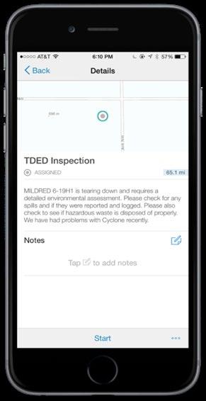
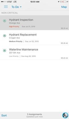
4 Collector for ArcGIS Workflows and Use Cases Collect and Maintain Asset Data Capture Observations Perform Field Assessments

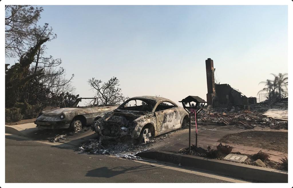
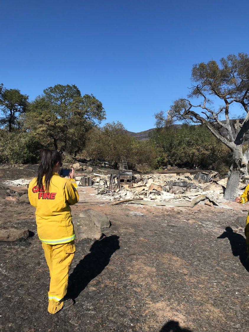

5 Wildfire Damage Assessment


6 Tree Inventory 2011 treating 500 trees 2017 treating 32,000 trees
7 Conceptual Workflow Create feature layers to collect data - ArcGIS Online and/or ArcGIS Enterprise Add to a web map - Share map and layers to a group Access in Collector for ArcGIS Feature Layer Web map Collector for ArcGIS
8 Data Sources Data collected is stored in a feature layer ArcGIS Online - Hosted feature layer - From an Enterprise geodatabase ArcGIS Enterprise 1. Portal for ArcGIS feature layer - Hosted data in ArcGIS Data Store 2. ArcGIS Server feature service - From an Enterprise geodatabase Collector for ArcGIS Feature Layer ArcGIS Online ArcGIS Enterprise A


9 Creating Feature Layers ArcGIS Pro* - Create new feature class - Share as a feature layer ArcGIS Online - Leverage feature layer templates - Over 50+ templates available - Many industry focused; can adjust as needed - E.g., Natural resources, Public safety, Utilities, etc. - Build a layer - Points, lines, and polygons *Note: ArcGIS Pro can also create web maps A
10 Feature Service Views Use to provide specific access and capabilities to different organization members Read-only views of information Limit information visible Asset Inventory Asset Inspection Field Monitoring Public Access Support offline workflows with multiple layers from the same source layer Feature Layer Views Primary Feature Layer
11 Collector for ArcGIS Configure Capabilities in Collector Some functionality determined by a combination of: - Feature layer properties - Web map properties Examples: - Feature style/rendering - Form appearance - Edit capabilities - Editor tracking Feature Layer Web map Collector for ArcGIS - Ability to take maps offline
12 Create a Web Map for Collector James Tedrick
13 What s New in Collector for ArcGIS v (Aurora) Status - ios: First release, Dec 3 rd week - Android: In beta, final release Q Themes - Better maps - Improved user experience - Enhanced collect experience - More offline options - Several new capabilities


14 Support for Better Maps Labels and advanced symbology - Support for Arcade expressions - Symbol effects and symbol properties Vector basemaps


15 Improved User Experience Focus on usability More intuitive UX New sliding panel Collector Classic New Collector A

16 Improved User Experience On tablets Effective use of screen size and orientation - E.g., Feels like a clipboard in portrait
17 Collector for ArcGIS Chris LeSueur


18 Collector for ArcGIS Advanced Topics Data collection with high accuracy Offline field collection Pairing with other Apps Feature Layer View
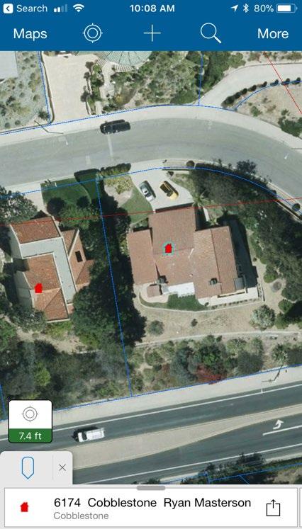
19 High Accuracy Data Collection Use Collector with GPS/GNSS device Set a location provider Define a location profile Attach accuracy information to your data Receive alerts and notifications GPS averaging 95% confidence interval setting Differential Corrections Support for Z values - Store orthometric heights Sub-meter accuracy


20 GPS/GNSS Receiver Compatibility
21 High Accuracy Data Collection Considerations Project accuracy requirements Supported receivers Correction services for receivers Datum transformations Desired basemap used for data collection

22 High Accuracy More Information UC 2018 Technical Workshop Working with High Accuracy Data presented by Kevin Burke and Morgan Zhang


23 Offline Data Collection Field users can take their maps offline - Measure distances and areas - Access popups and media - Search for features - Collect and update features - Synchronize changes between field and office Side load data - Tile packages and vector tile packages Disconnected 2 approaches 1. On demand 2. Pre-planned
24 Offline Workflows On-demand - Map author enables and configures maps for offline use - Field worker defines the area - Level of detail (raster tiles only) - Server processes data for each download Pre-planned - Map author defines the map areas for offline use - Field worker selects the area to work offline - Server processes data once A

25 Data Synchronization Synchronization: bi-directional process - Local edits are sent back to server - Server changes are pulled down to device Optional: include attachments Configure options in web map item properties - Settings > Offline ArcGIS Online ArcGIS Enterprise Synchronization Collector for ArcGIS A
26 Data Synchronization More options: 1. Sync in Map 2. Auto-Sync Sync panel shows pending edits and sync failures Collector has alerts and notifications


27 Preplanned Offline Maps James Tedrick


28 Pairing Collector for ArcGIS with other Apps Collect and Monitor Capture/Inspect Assigned Work Workforce Maps + Forms Collector Operations Dashboard Collector Survey123 Navigate and Update Third Party Integrations Collector Collector Navigator Custom App Collector A

29 Collector for ArcGIS Release Plan Release as new entry in the app store - ios, Dec 3 rd week - Android sometime Q Windows TBD Side-by-side release - Rename Collector to Classic in the app store

30 Collector for ArcGIS Road Ahead Smarter forms - More input types - Attribute rules - Grouping - Conditional visibility Continue to enhance UX Beta access: collectorbeta@esri.com


31 Print Your Certificate of Attendance Print Stations Located at L Street Bridge Tuesday 12:30 pm 6:30 pm GIS Solutions Expo Hall D Wednesday 10:45 am 5:15 pm GIS Solutions Expo Hall D 5:15 pm 6:30 pm GIS Solutions Expo Social Hall D 6:30 pm 9:00 pm Networking Reception National Building Museum


32 Please Take Our Survey on the App Download the Esri Events app and find your event Select the session you attended Scroll down to find the feedback section Complete answers and select Submit


33
Collector for ArcGIS
 Collector for ArcGIS Field GIS Taking GIS Beyond the Office Collecting Data Reporting Observations Managing Work Connecting the Field with the Enterprise Field Mobility Solutions Improve accuracy and currency
Survey123 for ArcGIS: An Introduction. James Tedrick Erin Densford
 Survey123 for ArcGIS: An Introduction James Tedrick Erin Densford Smart Forms for ArcGIS Easily convert paper forms into Digital Smart ArcGIS Forms Why Smart Forms in ArcGIS? Reduce Errors During Data
Introducing Survey123 For ArcGIS
 FedGIS Conference February 24 25, 2016 Washington, DC Introducing Survey123 For ArcGIS James Tedrick, Esri Jawameer Kakakhan, UN OCHA Configurable Solutions That Work Together Vizualize Collect Navigator
ArcGIS Runtime SDKs Building Offline Apps. Nick Furness
 ArcGIS Runtime SDKs Building Offline Apps Nick Furness Agenda The basics - Considerations - Building blocks - Service types New! Offline maps New! Preplanned workflow What we are covering and what not
Optimizing Field Operations. Jeff Shaner
 Optimizing Field Operations Jeff Shaner Field GIS Taking GIS Beyond the Office Collecting Data Reporting Observations Managing Work Connecting the Field with the Enterprise Workforce for ArcGIS Field workforce
Creating Geoprocessing Services and Web Tools. Darren Baird, PE, Esri
 Creating Geoprocessing Services and Web Tools Darren Baird, PE, Esri Introduction Both ArcMap and ArcGIS Pro are covered Terms Geoprocessing Services and Web Tools are the same - ArcMap publishes geoprocessing
ICAP - Intelligence Configuration for ArcGIS Pro. Natalie Feuerstein Dan Barnes Joe Bayles
 ICAP - Intelligence Configuration for ArcGIS Pro Natalie Feuerstein Dan Barnes Joe Bayles Overview Intelligence Analyst supporting Operations ArcGIS Pro SDK Intelligence Configuration for ArcGIS Pro -
ArcGIS Apps for the Mobile Worker. Presented by: Sue Enyedy-Goldner
 ArcGIS Apps for the Mobile Worker Presented by: Sue Enyedy-Goldner Agenda 1. Overview of ArcGIS apps for mobile workflows 2. Considerations for configuring the best app for your workflow 3. Configuration
ArcGIS Apps for the Mobile Worker. Presented by: Sue Enyedy-Goldner
 ArcGIS Apps for the Mobile Worker Presented by: Sue Enyedy-Goldner Agenda 1. Overview of ArcGIS apps for mobile workflows 2. Considerations for configuring the best app for your workflow 3. Configuration
Collector for ArcGIS: Using Relationships with your Inspection Workflows. Morgan Zhang Kevin Burke
 Collector for ArcGIS: Using Relationships with your Inspection Workflows Morgan Zhang Kevin Burke What we will cover today Relationship overview Demo of feature to feature relationships Demo of feature
Using Collector for ArcGIS and Operations Dashboard for ArcGIS. Mike Sweeney Esri-Charlotte
 Using Collector for ArcGIS and Operations Dashboard for ArcGIS Mike Sweeney Esri-Charlotte Agenda The ArcGIS Platform Desktop Web Device Portal Cloud Server Online Content and Services On-Premises Available
ArcGIS Apps for the Mobile Worker. Presented by: Sue Enyedy-Goldner
 ArcGIS Apps for the Mobile Worker Presented by: Sue Enyedy-Goldner Agenda 1. Overview of ArcGIS apps for mobile workflows 2. Considerations for configuring the best app for your workflow 3. Configuration
Working with Feature Layers. Russell Brennan Gary MacDougall
 Working with Feature Layers Russell Brennan Gary MacDougall Working with Feature Layers Session will focus on feature access and editing Highlight new features added over the last few releases Agenda Introduction
Collector for ArcGIS Preparing for and Working in a disconnected environment
 Collector for ArcGIS Preparing for and Working in a disconnected environment Peter Nasuti, Dan Moore, Nicholas Davis Topics Covered With demonstrations throughout each step 1) What is Collector? What can
Android Team Awareness Kit (ATAK) and ArcGIS
 and ArcGIS") Android Team Awareness Kit (ATAK) and ArcGIS Darron Pustam Product Manager, Esri Craig Cleveland Product Engineer, Esri Verne LaClair Product Manager, PAR Agenda Connecting Intel and Operations in Real
Android Team Awareness Kit (ATAK) and ArcGIS Darron Pustam Product Manager, Esri Craig Cleveland Product Engineer, Esri Verne LaClair Product Manager, PAR Agenda Connecting Intel and Operations in Real
ArcGIS Apps: An Overview
 Federal GIS Conference February 9 10, 2015 Washington, DC ArcGIS Apps: An Overview Chris LeSueur Product Manager Marisa Cowdry NCMEC Agenda Apps Introduction Rugged Device Apps Essential Mapping Apps -
Web AppBuilder Presented by
 Web AppBuilder Presented by Agenda Product overview Web AppBuilder for ArcGIS tour What s new in the ArcGIS Online June 2016 update Customization Community and Resources Summary The ArcGIS Platform enables
Collector for ArcGIS. Paul Barker Bert Yagrich
 Collector for ArcGIS Paul Barker Bert Yagrich Agenda What are we going to cover today? ArcGIS as a platform for data collection Device strategy and field data collection Collector for ArcGIS an overview
Administering Your ArcGIS Enterprise Portal Bill Major Craig Cleveland
 Administering Your ArcGIS Enterprise Portal Bill Major Craig Cleveland Agenda Welcome & Introduction to ArcGIS Enterprise Portal for ArcGIS Administration - Basic Configuration - Advanced Configuration
ArcGIS Enterprise Security: An Introduction. Randall Williams Esri PSIRT
 ArcGIS Enterprise Security: An Introduction Randall Williams Esri PSIRT Agenda ArcGIS Enterprise Security for *BEGINNING to INTERMIDIATE* users ArcGIS Enterprise Security Model Portal for ArcGIS Authentication
ArcGIS Enterprise: Performance and Scalability Best Practices. Darren Baird, PE, Esri
 ArcGIS Enterprise: Performance and Scalability Best Practices Darren Baird, PE, Esri dbaird@esri.com What is ArcGIS Enterprise What s Included with ArcGIS Enterprise ArcGIS Server the core web services
Sharing Web Layers and Services in the ArcGIS Platform. Melanie Summers and Ty Fitzpatrick
 Sharing Web Layers and Services in the Platform Melanie Summers and Ty Fitzpatrick Agenda Platform overview - Web GIS information model - Two deployment options Pro Sharing - User experience and workflows
High Availability & Disaster Recovery. Witt Mathot
 High Availability & Disaster Recovery Witt Mathot Managing the Twin Risks to your Operations Data Loss Down Time Business Continuity Terminology Resiliency High Availability RTO Round Robin Cost Business
ArcGIS GeoEvent Server: Leveraging Stream Services. Ken Gorton RJ Sunderman
 ArcGIS GeoEvent Server: Leveraging Stream Services Ken Gorton RJ Sunderman Agenda 1 2 3 4 5 Overview of Stream Services & Stream Layers Publishing Stream Services Visualization of real-time data Sample
Python: Beyond the Basics. Brittney White
 Python: Beyond the Basics Brittney White Topics Covered Cursors Geometry objects Leveraging other Python modules Cursors Used to: - Iterate over the set of rows in a table - Insert new rows into a table
What Makes a good content item GREAT?
 What Makes a good content item GREAT? Keith VanGraafeiland Tuesday - 4:30 PM - 5:15 PM SDCC - Demo Theater 04 - Living Atlas Overview Subhead Here Content items in ArcGIS Online Difficult to find what
ArcGIS Enterprise: Portal Administration BILL MAJOR CRAIG CLEVELAND
 ArcGIS Enterprise: Portal Administration BILL MAJOR CRAIG CLEVELAND Agenda Welcome & Introduction to ArcGIS Enterprise Portal for ArcGIS - Basic Configuration - Advanced Configuration - Deploying Apps
Trimble GeoCollector for ArcGIS: An Introduction. Morgan Zhang (Esri), Matthew Morris (Trimble)
, Matthew Morris (Trimble)") Trimble GeoCollector for ArcGIS: An Introduction Morgan Zhang (Esri), Matthew Morris (Trimble) Overview Introduction to mobile GIS Overview of ArcGIS for Windows Mobile Overview of Trimble Positions software
Trimble GeoCollector for ArcGIS: An Introduction Morgan Zhang (Esri), Matthew Morris (Trimble) Overview Introduction to mobile GIS Overview of ArcGIS for Windows Mobile Overview of Trimble Positions software
ArcGIS Enterprise Security: An Introduction. Gregory Ponto & Jeff Smith
 ArcGIS Enterprise Security: An Introduction Gregory Ponto & Jeff Smith Agenda ArcGIS Enterprise Security Model Portal for ArcGIS Authentication Authorization Building the Enterprise Encryption Collaboration
Collector for ArcGIS. Paul Barker and Russ Roberts
 Collector for ArcGIS Paul Barker and Russ Roberts Agenda A quick look at the mobile landscape ArcGIS the platform Looking at the problem What is Collector for ArcGIS Demo Quick tips What s next? Questions
ArcPad An Introduction
 2013 Esri International User Conference July 8 12, 2013 San Diego, California Technical Workshop ArcPad An Introduction Chris LeSeuer, Marika Vertzonis, Hannah Ferrier Esri UC2013. Technical Workshop.
Real-Time & Big Data GIS: Best Practices. Suzanne Foss Josh Joyner
 Real-Time & Big Data GIS: Best Practices Suzanne Foss Josh Joyner ArcGIS Enterprise With Real-time Capabilities Desktop Apps APIs visualization ingestion dissemination & actuation analytics storage Agenda:
ArcGIS Runtime SDK for Qt: Building Apps. Koushik Hajra and Lucas Danzinger
 ArcGIS Runtime SDK for Qt: Building Apps Koushik Hajra and Lucas Danzinger Cross-platform apps Agenda for today Intro to Qt Framework and ArcGIS Runtime SDK for Qt App design patterns with this SDK SDK
An Introduction to GIS for developers
 An Introduction to GIS for developers Part 4: GIS Sharing Canserina Kurnia & Tom Shippee Agenda Web GIS ArcGIS Online Cloud-based ArcGIS Server ArcGIS Server on-premises ArcGIS a complete platform discover,
Navigator for ArcGIS an Introduction
 Esri Developer Summit March 8 11, 2016 Palm Springs, CA Navigator for ArcGIS an Introduction Scott Sandusky Navigator for ArcGIS Navigator for ArcGIS is a mobile app that gets your field workforce where
Understanding and Using Metadata in ArcGIS. Adam Martin Marten Hogeweg Aleta Vienneau
 Understanding and Using Metadata in ArcGIS Adam Martin Marten Hogeweg Aleta Vienneau Adam Martin National Government Account Management R&D Open Data Marten Hogeweg National Government Professional Services
A Developers Guide To Mobile GIS. David Cardella, Jeff Shaner
 A Developers Guide To Mobile GIS David Cardella, Jeff Shaner What is mobile GIS? Extends the reach of ArcGIS from the office to the field With a mobile GIS solution you can: - Carry your maps to the field
Developing Mobile Apps with the ArcGIS Runtime SDK for.net
 Developing Mobile Apps with the ArcGIS Runtime SDK for.net Rich Zwaap Morten Nielsen Esri UC 2014 Technical Workshop Agenda The ArcGIS Runtime Getting started with.net Mapping Editing Going offline Geocoding
ArcGIS Online: Three-and-a-Half Ways to Create Tile Layers. Eric Anderson & Adam Eversole Esri Support Services
 ArcGIS Online: Three-and-a-Half Ways to Create Tile Layers Eric Anderson & Adam Eversole Esri Support Services Agenda 1. Introduction 2. What is a tile layer 3. How a tile layer works 4. The 3 ½ ways to
ArcGIS Runtime SDK for Java: A Beginner s Guide. Mark Baird JC Malott
 ArcGIS Runtime SDK for Java: A Beginner s Guide Mark Baird JC Malott Outline Intro to ArcGIS Runtime SDKs Get started: download and install the SDK Tour of the functionality of the API Basics of building
Developing Qt Apps with the Runtime SDK
 Developing Qt Apps with the Runtime SDK Thomas Dunn and Michael Tims Esri UC 2014 Technical Workshop Agenda Getting Started Creating the Map Geocoding and Routing Geoprocessing Message Processing Work
BEST PRACTICES FOR MAP DESIGN: ADVANCED
 FedGIS Conference February 13-14, 2017 Washington, DC BEST PRACTICES FOR MAP DESIGN: ADVANCED CREATING A BASEMAP FOR AN ORGANIZATION'S PURPOSE, PLACES AND PEOPLE Billie Leff, Esri bleff@esri.com David
Getting Started with ArcGIS Runtime. Jeff Shaner David Cardella
 Getting Started with ArcGIS Runtime Jeff Shaner David Cardella Agenda ArcGIS Runtime SDK Overview WPF SDK Java SDK ios, Android, Win Phone SDKs Road Ahead Making ArcGIS available from any device anywhere
Getting Started with ArcGIS Runtime SDK for Qt. Thomas Dunn & Nandini Rao
 Getting Started with ArcGIS Runtime SDK for Qt Thomas Dunn & Nandini Rao Agenda Getting Started Creating the Map Geocoding and Routing Geoprocessing Message Processing Work Offline The Next Release ArcGIS
Understanding and using Metadata across the ArcGIS Platform. Aleta Vienneau Marten Hogeweg
 Understanding and using Metadata across the ArcGIS Platform Aleta Vienneau Marten Hogeweg Understanding and using Metadata across the ArcGIS Platform Metadata fundamentals ArcGIS platform Road ahead Metadata
Application of GIS to Cybersecurity. Brian Biesecker Ken Mitchell
 Application of GIS to Cybersecurity Brian Biesecker Ken Mitchell Fundamental Problems that GIS can help you solve What are the impacts to your mission, operations, business activities, critical systems,
ArcGIS for Mobile Devices: An Overview. Jeff Shaner Bonnie Stayer
 ArcGIS for Mobile Devices: An Overview Jeff Shaner Bonnie Stayer Agenda Esri Positioning and Key Benefits Your Mobility Strategy Q & A Positioning and Benefits Key Benefits of Mobile Solutions Leverage
ArcGIS Enterprise Performance and Scalability Best Practices. Andrew Sakowicz
 ArcGIS Enterprise Performance and Scalability Best Practices Andrew Sakowicz Agenda Definitions Design workload separation Provide adequate infrastructure capacity Configure Tune Test Monitor Definitions
Architecting the ArcGIS Platform: Best Practices. Raymond Bunn, GISP, PMP Esri Patterns & Practices Solution Architect
 Architecting the ArcGIS Platform: Best Practices Raymond Bunn, GISP, PMP Esri Patterns & Practices Solution Architect E M E R A L D S A P P H I R E T H A N K Y O U T O O UR SPONSORS Please Take Our Survey
ArcPad An Introduction
 ArcPad An Introduction Chris LeSueur, Marika Vertzonis, Hannah Ferrier ArcPad Sessions at the UC Demo Theatre - Preparing and Deploying Data to ArcPad - Using ArcPad in the Field - Customizing ArcPad without
Introduction to Your First ArcGIS Enterprise Deployment. Thomas Edghill & Jonathan Quinn
 Introduction to Your First ArcGIS Enterprise Deployment Thomas Edghill & Jonathan Quinn Overview Web GIS options with Esri Building a Base ArcGIS Enterprise Deployment - Overview of Base ArcGIS Enterprise
ArcGIS Runtime SDK for ios and macos: Building Apps. Suganya Baskaran, Gagandeep Singh
 ArcGIS Runtime SDK for ios and macos: Building Apps Suganya Baskaran, Gagandeep Singh Get Started Core Components Agenda - Display Map Content - Search for Content - Perform Analysis - Edit Content Summary
ArcGIS Online: Best Practices for High-Demand Web Applications. Kelly Gerrow-Wilcox Bonnie Stayer Beth Romero
 ArcGIS Online: Best Practices for High-Demand Web Applications Kelly Gerrow-Wilcox Bonnie Stayer Beth Romero Agenda Communicating with Maps Who do you build your apps for? Layer Types Scalability and Response
Best Practices for Designing Effective Map Services
 FedGIS Conference February 24 25, 2016 Washington, DC Best Practices for Designing Effective Map Services James Tedrick, Esri Matt Sokol, MD Dept. of Information Technology Web Mapping & Service Types
An Introduction to Using Lidar with ArcGIS and 3D Analyst
 FedGIS Conference February 24 25, 2016 Washington, DC An Introduction to Using Lidar with ArcGIS and 3D Analyst Jim Michel Outline Lidar Intro Lidar Management Las files Laz, zlas, conversion tools Las
Getting Started with the ArcGIS Runtime SDKs. Dave, Will, Euan
 Getting Started with the ArcGIS Runtime SDKs Dave, Will, Euan Agenda Why native app development? What can you do with the runtime SDKs Latest release Future Native Apps Are Everywhere Apple s App Store
Getting Started with ArcGIS Runtime SDK for Java SE
 Getting Started with ArcGIS Runtime SDK for Java SE Elise Acheson, Vijay Gandhi, and Eric Bader Demo Source code: https://github.com/esri/arcgis-runtime-samples-java/tree/master/devsummit-2014 Video Recording:
Building Java Apps with ArcGIS Runtime SDK
 Building Java Apps with ArcGIS Runtime SDK Mark Baird and Vijay Gandhi A step back in time Map making 50 years ago - http://www.nls.uk/exhibitions/bartholomew/maps-engraver - http://www.nls.uk/exhibitions/bartholomew/printing
Setup Guide for Op Tracker
 Setup Guide for Op Tracker Contents 1 Welcome to Op Tracker... 2 2 Data Overview... 3 2.1 Block Boundary Feature Layer... 3 2.2 Block Tracking Feature Layer... 3 2.3 Ancillary Data Feature Layer... 3 2.4
Developing mapping applications with ArcGIS Runtime SDK for ios. Divesh Goyal Eric Ito
 Developing mapping applications with ArcGIS Runtime SDK for ios Divesh Goyal Eric Ito Agenda Directions & Navigation Finding places and addresses Accessing your map content What is a mapping app? Introduction
Enabling High-Quality Printing in Web Applications. Tanu Hoque & Jeff Moulds
 Enabling High-Quality Printing in Web Applications Tanu Hoque & Jeff Moulds Print Service Technical Session Outline What s new in 10.6x What is Print Service Out of the box print solutions Print service
Configuring the ArcGIS for Local Government Solution
 Configuring the ArcGIS for Local Government Solution Lindsay Thomas Steve Grise Scott Oppmann Esri UC 2015 Technical Workshop Agenda Introduction Configuration Patterns Implementation Approaches Your Feedback
Building Applications with the ArcGIS Runtime SDK for WPF
 Esri International User Conference San Diego, California Technical Workshops 24 th July 2012 Building Applications with the ArcGIS Runtime SDK for WPF Euan Cameron & Paul Pilkington Agenda Introduction
Architect your deployment using Chef
 ArcGIS Enterprise Architect your deployment using Chef Cherry Lin and Scott MacDonald ArcGIS Enterprise base deployment Why automate your ArcGIS Enterprise deployment? Efficiency Get up and running faster
Does Your Data Have Harmony. Dan Stone
 Does Your Data Have Harmony Dan Stone Agenda Introduction Configuration Patterns Implementation Approaches Your Feedback ArcGIS for Local Government Esri solutions for local government customers Series
How To Configure & Use Insights for ArcGIS ARAVIND SIVASAILAM MATT THOMAS
 How To Configure & Use Insights for ArcGIS ARAVIND SIVASAILAM MATT THOMAS Who is this for? ArcGIS Enterprise Publishers & Administrators ArcGIS Enterprise Users (Little to No Experience with Insights)
ArcGIS Pro Editing: An Introduction. Jennifer Cadkin & Phil Sanchez
 ArcGIS Pro Editing: An Introduction Jennifer Cadkin & Phil Sanchez See Us Here WORKSHOP ArcGIS Pro Editing: An Introduction LOCATION SDCC - Ballroom 20 D TIME FRAME Thursday 10:00 11:00 ArcGIS Pro: 3D
Using the ESRI Collector App: A User s Manual
 Using the ESRI Collector App: A User s Manual Produced by Jim Groot and Carrie Thomas Edited by Erik Cammeraat, Harry Seijmonsbergen and Thijs de Boer Summer 2017 1 Contents Introduction... 3 Getting Started...
Getting Started with ArcGIS Runtime SDK for the Microsoft.NET Framework. Morten Nielsen Mike Branscomb Antti Kajanus Rex Hansen
 Getting Started with ArcGIS Runtime SDK for the Microsoft.NET Framework Morten Nielsen Mike Branscomb Antti Kajanus Rex Hansen Agenda What is the ArcGIS Runtime? ArcGIS Runtime SDK for.net - Platform -
ArcGIS Desktop The Road Ahead. Amadea Azerki
 ArcGIS Desktop The Road Ahead Amadea Azerki Agenda An Overview of ArcGIS 10 Desktop Enhancements User Interface Mapping Editing Analysis Sharing Q & A ArcGIS 10 Overview Focuses on Usability and Productivity
ArcGIS Runtime SDKs: Building a Routing Application. Frank Kish Konstantin Kutsner
 ArcGIS Runtime SDKs: Building a Routing Application Frank Kish Konstantin Kutsner Overview What goes into a routing application Data connected \ disconnected Demo creating mmpk API Demo code Other Resources
Configuring ArcGIS Enterprise in Disconnected Environments
 Configuring ArcGIS Enterprise in Disconnected Environments BILL MAJOR Disconnected Environments Not everyone has internet access? How many of you run disconnected today, i.e. no internet access? Many customers
TRAINING GUIDE. Tablet: Cradle to Mobile GIS
 TRAINING GUIDE Tablet: Cradle to Mobile GIS Tablet Cradle to Mobile One of the critical components of mobile is the GIS piece, and also can be the most complex. The mobile GIS maps are designed to consume
TRAINING GUIDE. ArcGIS Online and Lucity
 TRAINING GUIDE ArcGIS Online and Lucity ArcGIS Online and Lucity This covers some basic functionality we feel you will need to be successful with Lucity with ArcGIS Online or Portal for ArcGIS Enterprise.
VECTOR TILES: STYLING YOUR OWN BASE MAPS. Andrew Green René Rubalcava Andy Skinner
 VECTOR TILES: STYLING YOUR OWN BASE MAPS Andrew Green René Rubalcava Andy Skinner Introducing Vector Tiles Andrew Green What are Esri Vector Tile Basemaps? Introduction Basemaps cached and delivered as
ArcGIS Online. The Road Ahead Geoff Mortson
 ArcGIS Online The Road Ahead Geoff Mortson gmortson@esricanada.com ArcGIS Online Easily create and share maps Delivered as intelligent maps Access on virtually any device anyone, anywhere Compliments and
ArcGIS Pro Editing. Jennifer Cadkin & Phil Sanchez
 ArcGIS Pro Editing Jennifer Cadkin & Phil Sanchez ArcGIS Pro Editing Overview Provides tools that allow you to maintain, update, and create new data - Modifying geometry, drawing new features - Entering
An introduction to ArcGIS Runtime
 2013 Europe, Middle East, and Africa User Conference October 23-25 Munich, Germany An introduction to ArcGIS Runtime Christine Brunner Lars Schmitz Welcome! Christine Brunner, Germany - Software Developer
ArcGIS Runtime SDK for Android An Introduction. Xueming
 ArcGIS Runtime SDK for Android An Introduction Dan O Neill @jdoneill @doneill Xueming Wu @xuemingrocks Agenda Introduction to the ArcGIS Android SDK Maps & Layers Basemaps (Portal) Location Place Search
TRAINING GUIDE. GIS Session Preview (New Features) 2017 and 2017r2
 2017 and 2017r2") TRAINING GUIDE GIS Session Preview (New Features) 2017 and 2017r2 GIS Session Preview (New Features) 2017 and 2017r2 In this session, we ll provide an overview of GIS changes since ACT 2016 and a sneak
TRAINING GUIDE GIS Session Preview (New Features) 2017 and 2017r2 GIS Session Preview (New Features) 2017 and 2017r2 In this session, we ll provide an overview of GIS changes since ACT 2016 and a sneak
Ensuring the Deer and Antelope Play Free
 IPMA Professional Development Seminar Ensuring the Deer and Antelope Play Free A success story using Survey123 ROB SMITH DATABASE WIZARD WSDOT ENVIRONMENTAL SERVICES OFFICE JESSE ALTON GIS & DATA MANAGER
ESRI Mobile GIS Solutions Overview. Justin Fan
 ESRI Mobile GIS Solutions Overview Justin Fan Agenda Mobile GIS challenges ESRI Mobile GIS solutions ArcPad ArcGIS Mobile ArcGIS Engine Selecting a mobile GIS solution Q & A Objective To help you select
ArcGIS Runtime: Styling Maps. Lucas Danzinger and Michael Wilburn
 ArcGIS Runtime: Styling Maps Lucas Danzinger and Michael Wilburn What is this session about? Creating functional maps for your Runtime Apps How to design beautiful and stylish maps with an emphasis on
Hit the Ground Running. ArcGIS Runtime SDK for Android
 Hit the Ground Running ArcGIS Runtime SDK for Android Presenters Dan O Neill - @jdoneill Xueming Wu Introduction to the Android SDK Maps & Layers Analysis & Display Information Place Search Offline Patterns
3D in the Browser with WebGL. Chris Andrews 3D Product Manager Javier Gutierrez 3D Product Engineer
 3D in the Browser with WebGL Chris Andrews 3D Product Manager Javier Gutierrez 3D Product Engineer Just sayin This is not a programming class Goal is to help you learn about a technology area that impacts
TRAINING GUIDE. Mobile for Administrators Part 3 - GIS
 TRAINING GUIDE Mobile for Administrators Part 3 - GIS Mobile for Administrators - GIS One of the critical components of mobile is GIS, and it can also be the most complex. The mobile GIS maps are designed
ArcGIS Runtime: Building 3D Apps. Rex Hansen Adrien Meriaux
 ArcGIS Runtime: Building 3D Apps Rex Hansen Adrien Meriaux Agenda 3D across the ArcGIS Platform 3D in ArcGIS Runtime Road ahead ArcGIS 3D helps customers Create and Manage Design and Simulate Visualize
System Design and Tuning
 System Design and Tuning Lucity 2018 R2 Overview Lucity Specifications 2018 R2 Web Identity Server Document Server File Server Database Server Service Server Citizen Portal Mobile Server Android Devices
Implementing ArcGIS Mobile Applications for the Enterprise
 Implementing ArcGIS Mobile Applications for the Enterprise Myles Sutherland Glenn Meister ESRI Developer Summit 2008 1 Schedule 75 minute session 60 65 minute lecture 10 15 minutes Q & A following the
ArcGIS GeoEvent Server: Leveraging Stream Services
 ArcGIS GeoEvent Server: Leveraging Stream Services James Cardona Web Developer DC R&D Center Tysons jcardona@esri.com RJ Sunderman GeoEvent Server Real-Time Capabilities rsunderman@esri.com Agenda Overview
Introduction to Web AppBuilder for ArcGIS: JavaScript Apps Made Easy
 Introduction to Web AppBuilder for ArcGIS: JavaScript Apps Made Easy Jianxia Song & Derek Law July 21, 2015 Agenda Product overview Web AppBuilder for ArcGIS tour What s New July 2015 ArcGIS Online update
Network Analysis with ArcGIS Online and On-premise Services
 2013 Esri International User Conference July 8 12, 2013 San Diego, California Technical Workshop Network Analysis with ArcGIS Online and On-premise Services Deelesh Mandloi Dmitry Kudinov Esri UC2013.
ArcGIS Data Reviewer: Ensuring Accurate and Complete Data to Meet Your Mission. John Grammer Kevin Pusey
 ArcGIS Data Reviewer: Ensuring Accurate and Complete Data to Meet Your Mission John Grammer Kevin Pusey Workshop agenda Defining data quality What is ArcGIS Data Reviewer? Automated review Semi-automated
What is new in ArcGIS 10.2.x for Server
 What is new in ArcGIS 10.2.x for Server Ismael Chivite, Greg Tieman Esri UC 2014 Technical Workshop Map cache status Windows and Linux friendly Simplified architecture 64 bit Performance Improvements Administration
ArcGIS Enterprise Extending Services. Bill Major
 ArcGIS Enterprise Extending Services Bill Major Agenda Introduction Geoprocessing tools Server Object Extensions Server Object Interceptors Demo APPS Desktop Web Device SHARING SERVICES Portal API DATA
Utility Network Management in ArcGIS: Migrating Your Data to the Utility Network. John Alsup & John Long
 Utility Network Management in ArcGIS: Migrating Your Data to the Utility Network John Alsup & John Long Presentation Outline Utility Network Preparation - Migration Patterns - Understanding the Asset Package
Building Apps with the ArcGIS Runtime SDK for ios
 Building Apps with the ArcGIS Runtime SDK for ios Nick Furness @geeknixta ArcGIS Runtime SDKs 10.2 Released! Runtime platforms OS X Desktop Desktop Client Windows Store QT ios.net JavaSE Mobile Android
Data Store Management Best Practices. Bill Major Laurence Clinton
 Data Store Management Best Practices Bill Major Laurence Clinton Session Agenda 1. Overview 2. Installation and Configuration 3. Backing up the data store 4. Restoring the data store 5. Moving data store
ArcGIS Runtime SDK for.net Building Apps. Antti Kajanus David Cardella
 ArcGIS Runtime SDK for.net Building Apps Antti Kajanus akajanus@esri.com David Cardella dcardella@esri.com Thank You to Our Generous Sponsor SDK Highlights High-performance 2D and 3D mapping Integration
ArcGIS Viewer for Microsoft Silverlight An Introduction
 Esri International User Conference San Diego, CA Technical Workshops July 12, 2011 ArcGIS Viewer for Microsoft Silverlight An Introduction Art Haddad, Rich Zwaap, and Derek Law Agenda Background Product