PV Developing Apps for tempo-spatial meteorological satellite data - using OGC Services. EUMETSAT ImageGallery Key Concepts for better MapApps
|
|
|
- Alexander Douglas
- 5 years ago
- Views:
Transcription
1 PV November 2011 CNES Toulouse, France Developing Apps for tempo-spatial meteorological satellite data - using OGC Services EUMETSAT ImageGallery Key Concepts for better MapApps Uwe Voges (con terra GmbH) Michael Schick (EUMETSAT) Udo Einspanier (con terra GmbH)

2 INTRODUCTION EUMETSAT New ImageGallery - Overview New EUMETSAT Image Gallery webapp: Under development in context of EO Portal EUMETSAT data is visualized by OGC Web Map Services (WMS), including o On-the-fly Image generation for user-defined area o retaining native resolution, data values, georeferencing information o WMS supporting horizontal and temporal Reference System (RS) o Important time support, e.g. moments (TIME= ) or intervals provision of OGC Web Services Coverage (WCS) Automatic updates of images regular 3- hourly feed by Slide: 2
 Available timerange for product is displayed User")

3 NEW IMAGE GALLERY: New ImageGallery VISUAL INSPECTION - UserInterface OF EO DATA - OVERVIEW Client shows global base data from a WMS User can select a product from a list Product is overlayed on base map (default: most recent) Available timerange for product is displayed User can: Zoom in/out, pan, toggle layer visibility, switch background layer Switch SRS (e.g. North Polar Stereographic) Add custom WMS Select date and time for product Show product abstract Display product in GoogleEarth Animation support: first select animation settings Slide: 3

4 FORMATS USED FOR PROTOTYPE New ImageGallery Server Data Organization meteorological products mainly stored in formats: BUFR (edition 4) GRIB (second edition) A B Read datasets Cinesat Copy datasets Write transformed datasets GeoTIFF database netcdf/ BUFR/GRIB database Read datasets Read datasets Read datasets Read datasets Conventional Data Server Conventional Map Server Cinesat converts into GeoTIFF EUMETSAT Archive netcdf/bufr/ Most COTS geodata and map GRIB server support GeoTIFF For temporal dimension a specific physical and logical view must be prepared: THREDDS ncwms WCS WMS WCS WMS one physical dataset for each timestep used Advantage: every image format can be used Web mapping requires logical organization of data as layers here: one single layer represents the whole period responsibility to request / return data for timeframe is on server & client-side Time selection tbd by special parameter within requests requires map service supporting WMS with dimension parameters Slide: 4
 and output formats Important(!")
5 ARCHITECTURE New OVERVIEW ImageGallery Implementation Server based on Geoserver open source, written in Java supports WMS- and WCS-Interfaces lots of input (incl GeoTIFF) and output formats Important(!): RESTful interface for configuration ArcGIS considered: good option Image Server extension for satellite data support WMS/WCS and RESTful config interface too lots of client development tools based on JS But: ArcGIS 10 last version with Solaris support For time dimension support a WMS Façade (servlet filter) was developed aggregates images representing points in time to virtual layer with time dimension (workspace) transforms WMS requests to WMS requests The latter reference image(s) corresponding to requested time) Slide: 5
 was implemented")


6 Geoserver Extension - Updating New ImageGallery Implementation Server/Client for automatic updates of images, a Publisher (Geoserver Updating) was implemented publishes new GeoTIFFs to Geoserver and creates configuration for WMS Façade via REST-Interface Image Gallery Client: webapp accessing products via WMS implemented with: Google Web Toolkit (GWT) 2.x JavaScriptAPI OpenLayers 2.8 for mapdisplay GWT-OpenLayers (Java wrapper to integrate OpenLayers with GWT) Slide: 6
7 Improving map Apps Frequent shortcomings of map applications (applies partly for the ImageGallery too): Focussed often on geo-it terminology : layers, CRS, opacity, user often do not (want to) know anything about this Content overload often provide too much content in one single app in parallel not focussed on specific content/solution Device often not recognized: Mobile solutions often don t consider device specific features Design: often driven by technologists and not by user interface designers Known concepts of app controls not considered Users prefer interface that is aligned with known concept Too much development needed For adaptations of existing apps or for the creation of new focussed apps there is much programming needed In the following a few key concepts will be shown which should be taken into account for better map apps Slide: 7
 for German Bundesland")
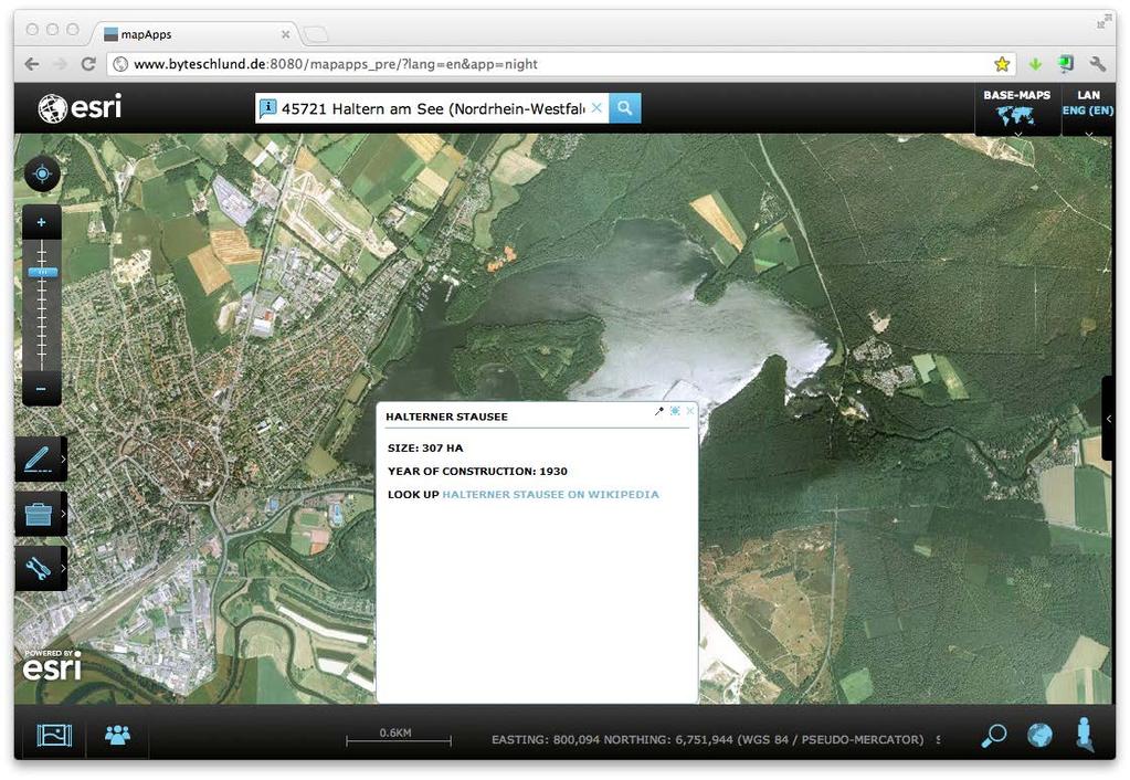
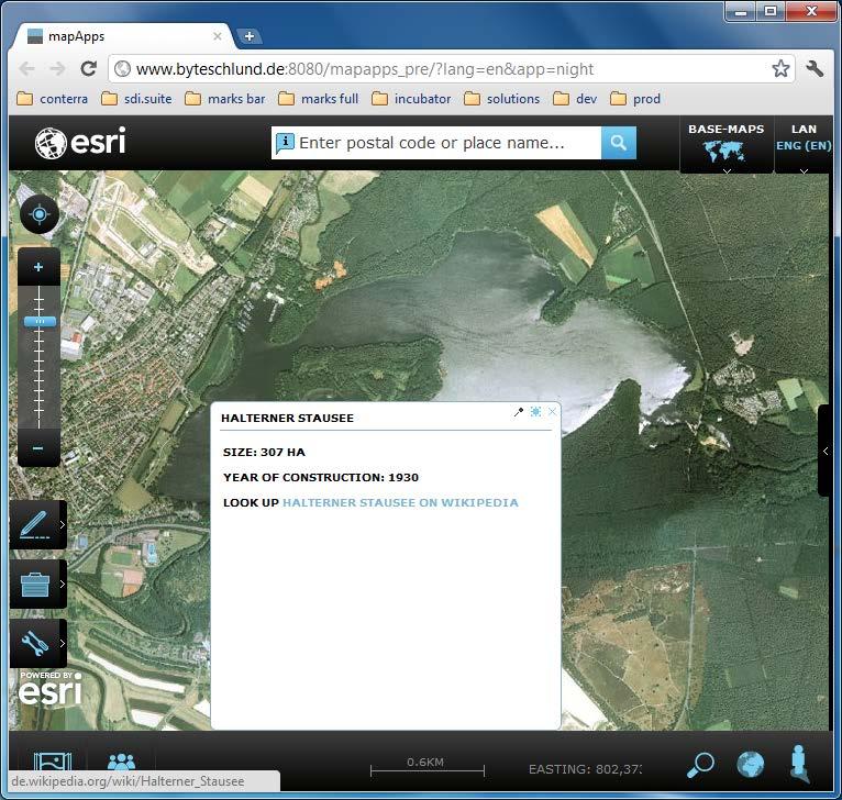
8 Problem Fit: Simplified & Focussed Risk analysis (flooding, heavy rain, storm) for German Bundesland Saxonia Slide: 8


9 Recognize the Context: Device Ground values for German Bundesland NRW


10 Design (better composed, more clear)
11 Known Concepts: mapflow (like music selection/information in ipod)
12 Known Concepts: mapflow

13 Known Concepts: mapflow
14 Known Concepts: mapflow
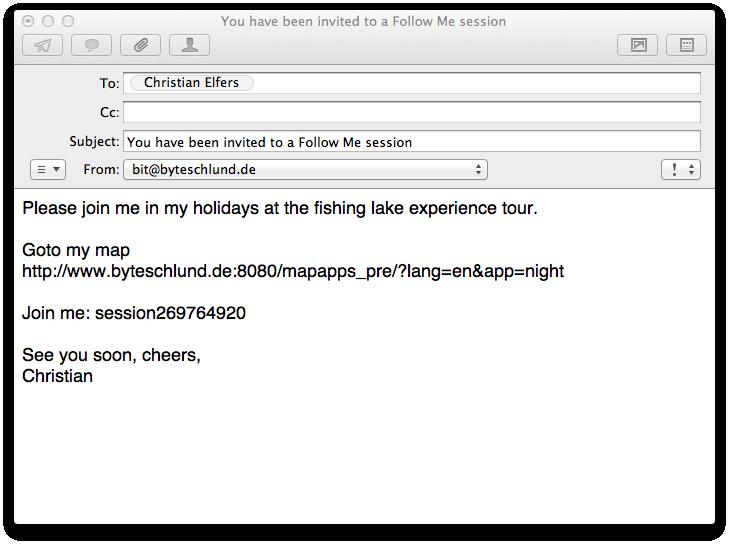
15 Collaboration: FollowMe
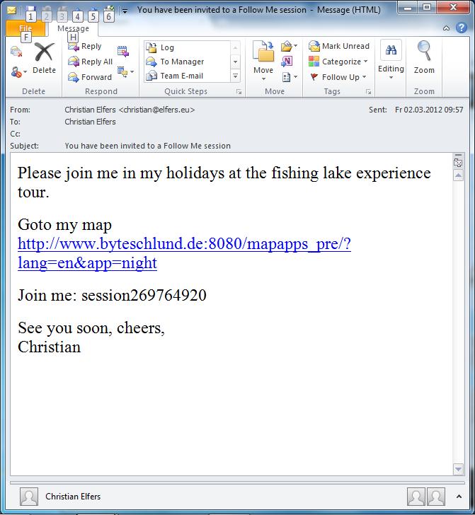
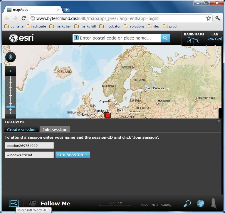
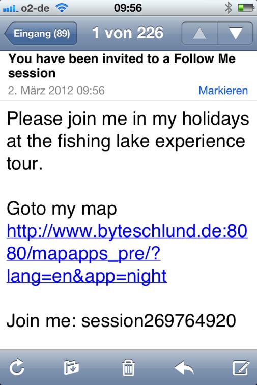
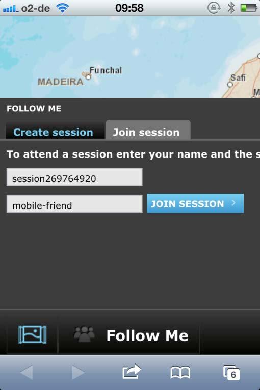
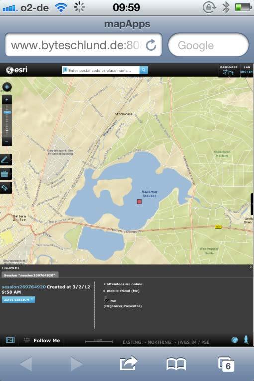
16 Collaboration: FollowMe
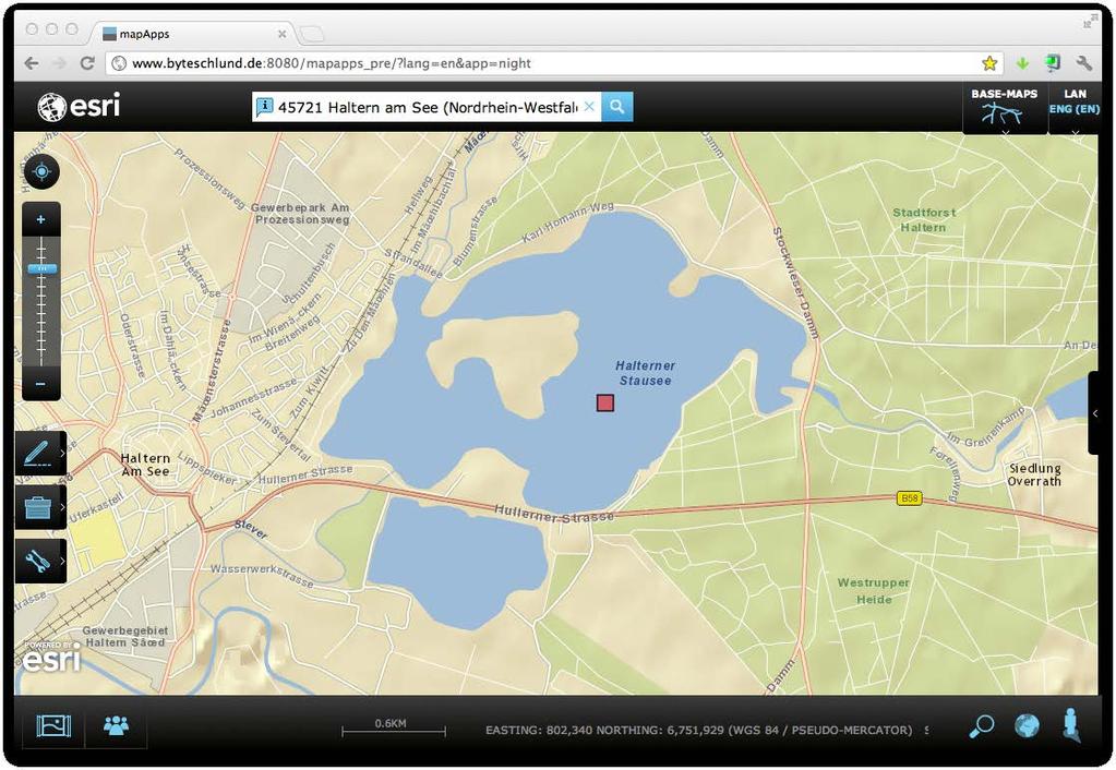
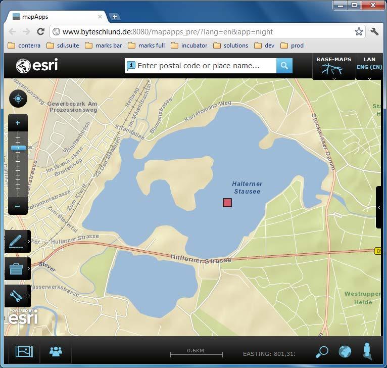
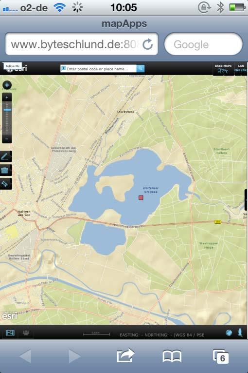
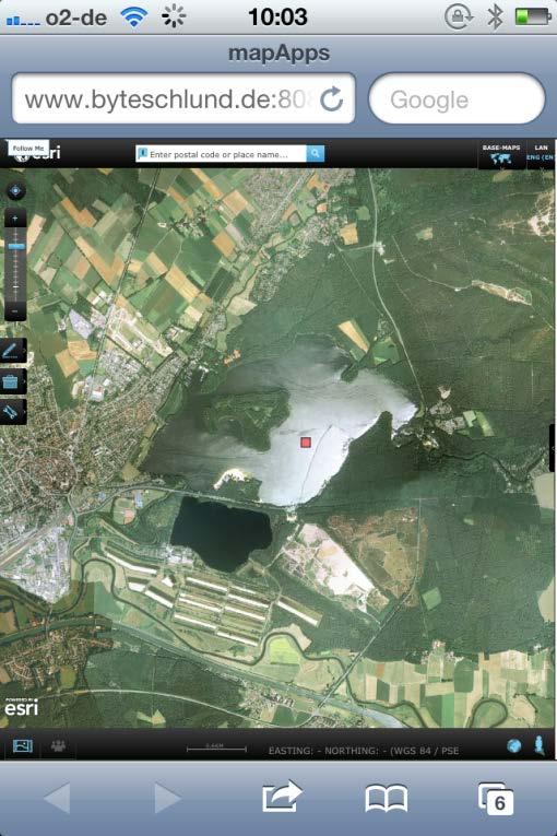
17 Collaboration: FollowMe
18 Collaboration: FollowMe

 Based on ArcGIS: Esri JavaScript API, REST API, ArcGIS Server, ArcGIS Online OSGi Framework for JavaScript s.")
19 map.apps - building geospatial app s for web and mobile map.apps: software solution to build focussed geospatially enabled app s in an attractive, easy-to-use form Provides Standard Architecture, Platform and Building Blocks Cross-platform (web/mobile) and cross-device capable Pure JavaScript/HTML(5) Client (no plug-ins) Based on ArcGIS: Esri JavaScript API, REST API, ArcGIS Server, ArcGIS Online OSGi Framework for JavaScript s. Javamagazin 3/2013 app.builder creates app`s based on App-Templates Slide: 19
Desarrollo de una herramienta de visualización de datos oceanográficos: Modelos y Observaciones
 Desarrollo de una herramienta de visualización de datos oceanográficos: Modelos y Observaciones J. Fernandez, J. Lopez, I. Carlos, F. Jerez, F. Hermosilla, M. Espino SIMO, LIM-UPC, CIIRC FIELD_AC 7 th
Working with Scientific Data in ArcGIS Platform
 Working with Scientific Data in ArcGIS Platform Sudhir Raj Shrestha sshrestha@esri.com Hong Xu hxu@esri.com Esri User Conference, San Diego, CA. July 11, 2017 What we will cover today Scientific Multidimensional
OGC at KNMI: Current use and plans
 OGC at KNMI: Current use and plans 4th Workshop on the use of GIS/OGC standards in meteorology 4 th of March 2013, Reading 1. Ernst de Vreede 2. Maarten Plieger Contents 1. ADAGUC 2. Internal applications
Metview 4 ECMWF s next generation meteorological workstation
 Metview 4 ECMWF s next generation meteorological workstation Iain Russell Graphics Section ECMWF Slide 1 21 st EGOWS, Reading, 1 4 June 2010 1 What is Metview? (1) Working environment for Operational and
Data Centre NetCDF Implementation Pilot
 Data Centre NetCDF Implementation Pilot Peter Miu EUMETSAT User Conference Oslo, Sep. 2011 Splinter Session, Facilitating Data Access and Utilisation Slide: 1 EUM/OPS/VWG/11/2600 V.1 What is this Pilot
Linking and Finding Earth Observation (EO) Data on the Web
 Data on the Web") Linking and Finding Earth Observation (EO) Data on the Web MACS-G20 Workshop: Linked Open Data in Agriculture Berlin, September 27-28, 2017 Dr. Uwe Voges u.voges@conterra.de Introduction Earth Observation
Linking and Finding Earth Observation (EO) Data on the Web MACS-G20 Workshop: Linked Open Data in Agriculture Berlin, September 27-28, 2017 Dr. Uwe Voges u.voges@conterra.de Introduction Earth Observation
Web Map Servers. Mark de Blois. Septembre 2016
 Web Map Servers Mark de Blois Septembre 2016 Learning Objectives After this lecture you will be able to understand web map servers as used in Web-GIS applications Introduction A Web Map Server is a computer
Scientific and Multidimensional Raster Support in ArcGIS
 Scientific and Multidimensional Raster Support in ArcGIS Sudhir Raj Shrestha sshrestha@esri.com Brief breakdown Scientific Multidimensional data Ingesting Scientific MultiDim Data in ArcGIS Ingesting and
Database Web Portal Version 1
 Database Web Portal Version 1 Deliverable D6.5 Issue 0.2 Due date of deliverable: 01 Dec 2014 Actual submission date: 05 Dec 2014 SEN3APP Processing Lines And Operational Services Combining Sentinel And
Online intercomparison of models and observations using OGC and community standards
 Online intercomparison of models and observations using OGC and community standards Alastair Gemmell * Jon Blower Keith Haines Adit Santokhee Reading e-science e Centre, Environmental Systems Science Centre,
Leveraging OGC Services in ArcGIS Server. Satish Sankaran, Esri Yingqi Tang, Esri
 Leveraging OGC Services in ArcGIS Server Satish Sankaran, Esri Yingqi Tang, Esri GIS Creating and Managing Geo Information Products - Proprietary - Open Specifications - Standards Dissemination of Geo
Introduction to GeoServer
 Tutorial ID: This tutorial has been developed by BVIEER as part of the IGET web portal intended to provide easy access to geospatial education. This tutorial is released under the Creative Commons license.
(Geo)DCAT-AP Status, Usage, Implementation Guidelines, Extensions
DCAT-AP Status, Usage, Implementation Guidelines, Extensions") (Geo)DCAT-AP Status, Usage, Implementation Guidelines, Extensions HMA-AWG Meeting ESRIN (Room D) 20. May 2016 Uwe Voges (con terra GmbH) GeoDCAT-AP European Data Portal European Data Portal (EDP): central
(Geo)DCAT-AP Status, Usage, Implementation Guidelines, Extensions HMA-AWG Meeting ESRIN (Room D) 20. May 2016 Uwe Voges (con terra GmbH) GeoDCAT-AP European Data Portal European Data Portal (EDP): central
OpenEO: an API that unifies access to Earth Observation data processing platforms. ifgi. Institute for Geoinformatics University of Münster
 1. Das neue IfGI-Logo 1.6 Logovarianten OpenEO: an API that unifies access to Earth Observation data processing platforms Logo für den Einsatz in internationalen bzw. englischsprachigen Präsentationen.
The challenges of the ECMWF graphics packages
 The challenges of the ECMWF graphics packages Sylvie Lamy-Thépaut Graphics Section ECMWF Slide 1 1 Outline Who are we? - ECMWF - The Graphics Section What are our Missions? - Magics - Metview - Wrep :
Implementation and Use of OGC/HMA/WMO/ISO & Inspire Standards in EUMETSAT EO Portal
 Third Workshop on the use of GIS/OGC Standards in Meteorology 15-17 November 2010 at the Met Office, Exeter, UK Implementation and Use of OGC/HMA/WMO/ISO & Inspire Standards in EUMETSAT EO Portal Uwe Voges
Development of Java Plug-In for Geoserver to Read GeoRaster Data. 1. Baskar Dhanapal CoreLogic Global Services Private Limited, Bangalore
 Development of Java Plug-In for Geoserver to Read GeoRaster Data 1. Baskar Dhanapal CoreLogic Global Services Private Limited, Bangalore 2. Bruce Thelen CoreLogic Spatial Solutions, Austin, USA 3. Perumal
County of Los Angeles. Chief Information Office Preferred Technologies for Geographic Information Systems (GIS) Version 2 May 2015
 Version 2 May 2015") County of Los Angeles Chief Information Office Preferred Technologies for Geographic Information Systems (GIS) Version 2 May 2015 CIO Preferred Technologies for GIS This document lists the preferred Geographic
County of Los Angeles Chief Information Office Preferred Technologies for Geographic Information Systems (GIS) Version 2 May 2015 CIO Preferred Technologies for GIS This document lists the preferred Geographic
3D in the Browser with WebGL. Chris Andrews 3D Product Manager Javier Gutierrez 3D Product Engineer
 3D in the Browser with WebGL Chris Andrews 3D Product Manager Javier Gutierrez 3D Product Engineer Just sayin This is not a programming class Goal is to help you learn about a technology area that impacts
CF-netCDF and CDM. Ethan Davis, John Caron, Ben Domenico, Stefano Nativi* UCAR Unidata Univ of Florence*
 CF-netCDF and CDM Ethan Davis, John Caron, Ben Domenico, Stefano Nativi* UCAR Unidata Univ of Florence* OGC in MetOcean, Toulouse, France, November 2009 CF-netCDF and CDM CF-netCDF CDM/netCDF-java TDS
ERDAS Image Web Server Datasheet
 ERDAS Image Web Server Datasheet age 1 of 10 ERDAS Image Web Server Image serving protocols Multi-protocol support Expose images with different protocols. ERDAS Compressed Wavelet Protocol (ECWP) image
Open Source Software: What and Why?
 ESRI and Open Source A Love Story Presented by Bates Rambow Open Source Software: What and Why? What Software that has its source code published for anyone to inspect the source code. Generally released
BROWSER. LuciadRIA DATA SHEET
 BROWSER LuciadRIA DATA SHEET V2017 V2017.0 DATA SHEET LuciadRIA is the answer to today s demands for powerful, lightweight applications in the browser. Driven by today s most advanced web technologies,
SEXTANT 1. Purpose of the Application
 SEXTANT 1. Purpose of the Application Sextant has been used in the domains of Earth Observation and Environment by presenting its browsing and visualization capabilities using a number of link geospatial
BlomURBEX. Whitepaper. BLOM ASA partners and developers. BlomURBEX WhitePaper v5.0r1.0a
 BlomURBEX Whitepaper Audience: BLOM ASA partners and developers BlomURBEX WhitePaper v5.0r1.0a Table of Contents 1 What is BlomURBEX TM... 1 1.1 The BlomURBEX TM platform... 1 2 BlomURBEX TM datasets...
Using the Network Common Data Form for storage of atmospheric data
 Using the Network Common Data Form for storage of atmospheric data Maarten Plieger Royal Netherlands Meteorological Institute The NetCDF4 data format (Network Common Data Form) is used within the ADAGUC
Caching Tile Cache Creation & Management
 Exploring Options for Map Caching Tile Cache Creation & Management Presented By: Todd Wascher, Business Development Manager 04.21.2011 We Visualize Your World Whachutalkinbout? What we ll cover with this
Steve Ansari *, Stephen Del Greco, Neal Lott NOAA National Climatic Data Center, Asheville, North Carolina 2. DATA
 5A.1 THE WEATHER AND CLIMATE TOOLKIT Steve Ansari *, Stephen Del Greco, Neal Lott NOAA National Climatic Data Center, Asheville, North Carolina ABSTRACT The Weather and Climate Toolkit (WCT) is free, platform
PF-III User Guide for GUI and API - validation phase
 PF-III User Guide for GUI and API - validation phase Doc.No. : EUM/OPS/MAN/18/983019 Issue : v1a Date : 7 June 2018 WBS/DB : S EUMETSAT Eumetsat-Allee 1, D-64295 Darmstadt, Germany T l 49 6151 807 7 EUMETSAT
SuperGIS Server 3.2 Value Edition Specification
 SuperGIS Server 3.2 Value Edition Specification 20140826 Specification 1. All of the services support SOAP (Simple Object Access Protocol). 2. Use map file created by SuperGIS Desktop as map services SuperGIS
Zornitza Yovcheva Corné van Elzakker Barend Köbben. 3 rd Workshop on Usability of GI Ordnance Survey
 Zornitza Yovcheva Corné van Elzakker Barend Köbben 3 rd Workshop on Usability of GI Ordnance Survey 10.11.2010 Groupware: E mail for asynchronous group work Domain expert user Domain expert user The map:
Usability Evaluations and Improvements for an Online Volunteered Map Feedback Application. Jonathan E. Van Dusen University of Waterloo
 Usability Evaluations and Improvements for an Online Volunteered Map Feedback Application Jonathan E. Van Dusen University of Waterloo Introduction Web 2.0: dynamic platform allowing real-time content
Bruce Wright, John Ward, Malcolm Field, Met Office, United Kingdom
 The Met Office s Logical Store Bruce Wright, John Ward, Malcolm Field, Met Office, United Kingdom Background are the lifeblood of the Met Office. However, over time, the organic, un-governed growth of
ERDAS APOLLO v2013. What s New. SMARTERDECISIONS
 ERDAS APOLLO v2013 What s New. SMARTERDECISIONS 1 ERDAS APOLLO v2013 ERDAS APOLLO Professional: includes all the functionality of ERDAS APOLLO Advantage. In addition, it provides server side geoprocessing
Leveraging metadata standards in ArcGIS to support Interoperability. Aleta Vienneau and Marten Hogeweg
 Leveraging metadata standards in ArcGIS to support Interoperability Aleta Vienneau and Marten Hogeweg Leveraging metadata standards in ArcGIS to support Interoperability Overview of metadata standards
Esri and MarkLogic: Location Analytics, Multi-Model Data
 Esri and MarkLogic: Location Analytics, Multi-Model Data Ben Conklin, Industry Manager, Defense, Intel and National Security, Esri Anthony Roach, Product Manager, MarkLogic James Kerr, Technical Director,
eccharts and Metview 4 2 new visualisation systems at ECMWF
 eccharts and Metview 4 2 new visualisation systems at ECMWF Sylvie Lamy-Thépaut Meteorological Visualisation Section ECMWF Slide 1 eccharts and Metview 4 eccharts Web application - Response Time, Monitoring
Getting Started with ArcGIS for Server. Charmel Menzel and Ken Gorton
 Getting Started with ArcGIS for Server Charmel Menzel and Ken Gorton Agenda What is ArcGIS for Server? Types of Web services Publishing resources onto the Web Clients to ArcGIS for Server Editions and
GeoPlanner Workshop. Esri Ocean GIS Forum November 4, Pete Aniello and Rob Stauder
 GeoPlanner Workshop Esri Ocean GIS Forum November 4, 2015 Pete Aniello and Rob Stauder Purpose and Take-aways Learn how to: - Create services - Use services in ArcGIS Online - Use services in GeoPlanner
TerrainOnDemand ArcGIS
 TM TerrainOnDemand ArcGIS Connect to Intermap Technologies NEXTMap data within: ArcGIS Desktop 9.3.1 and Above AGDQS0312 TerrainOnDemand ArcGIS 2 TerrainOnDemand ArcGIS Table of Contents 1. Introduction...1
ArcGIS Viewer for Microsoft Silverlight An Introduction
 Esri International User Conference San Diego, CA Technical Workshops July 12, 2011 ArcGIS Viewer for Microsoft Silverlight An Introduction Art Haddad, Rich Zwaap, and Derek Law Agenda Background Product
Managing Image Data on the ArcGIS Platform Options and Recommended Approaches
 Managing Image Data on the ArcGIS Platform Options and Recommended Approaches Peter Becker Petroleum requirements for imagery and raster Traditional solutions and issues Overview of ArcGIS imaging capabilities
The EOC Geoservice: Standardized Access to Earth Observation Data Sets and Value Added Products ABSTRACT
 The EOC Geoservice: Standardized Access to Earth Observation Data Sets and Value Added Products K. Dengler, T. Heinen, A. Huber, K. Molch, E. Mikusch German Aerospace Center (DLR) German Remote Sensing
Extend GIS. The Reach. Of Your GIS. Chris Cappelli Nathan Bennett
 Extend The Reach GIS Of Your GIS Chris Cappelli Nathan Bennett Where do your co-workers, managers, customers, and citizens go when they want to find or make a map? GIS is a practical system for problem
The GeoPortal Cookbook Tutorial
 The GeoPortal Cookbook Tutorial Wim Hugo SAEON/ SAEOS SCOPE OF DISCUSSION Background and Additional Resources Context and Concepts The Main Components of a GeoPortal Architecture Implementation Options
An Introduction to GIS for developers
 An Introduction to GIS for developers Part 4: GIS Sharing Canserina Kurnia & Tom Shippee Agenda Web GIS ArcGIS Online Cloud-based ArcGIS Server ArcGIS Server on-premises ArcGIS a complete platform discover,
Dynamic Situational Awareness. Through Developer Applications
 Dynamic Situational Awareness Through Developer Applications Mission Focused Applications Building Apps to support operations Agile Simple High-Performance Defense Developers GIS Simplifies Working With
Integrating OGC web services into Metview and Magics++
 Integrating OGC web services into Metview and Magics++ Developing ECMWF s tools for OGC web services Sylvie Lamy-Thépaut, Stephan Siemen, Fernando Ii, Slide 1 Sándor Kertész,Vesa Karhila, Iain Russel Graphics
Providing Interoperability Using the Open GeoServices REST Specification
 2013 Esri International User Conference July 8 12, 2013 San Diego, California Technical Workshop Providing Interoperability Using the Open GeoServices REST Specification Satish Sankaran Kevin Sigwart What
Getting Started with the JS API for Multidimensional Image Services. Hong Xu, Wenxue Ju
 Getting Started with the JS API for Multidimensional Image Services Hong Xu, Wenxue Ju Outline How to publish a multidimensional image service - ArcGIS multidimensional data model JS API for multidimensional
Introduction to INSPIRE. Network Services
 Introduction to INSPIRE. Network Services European Commission Joint Research Centre Institute for Environment and Sustainability Digital Earth and Reference Data Unit www.jrc.ec.europa.eu Serving society
Developing a Free and Open Source Software based Spatial Data Infrastructure. Jeroen Ticheler
 Developing a Free and Open Source Software based Spatial Data Infrastructure Jeroen Ticheler 1 License This work is licensed under the Creative Commons Attribution-NonCommercial-ShareAlike 2.5 License.
Accessing OGC Services To access OGC WMS and WFS open the service in the directory that you want to consume, and click on either WMS or WFS.
 Using Web Services Web Services Overview This user guide contains instructions on how to consume a range of services through a range of both web based and desktop GIS applications. Web services are a live
Esri Geoportal Server
 Esri Geoportal Server Implementing a Spatial Data Infrastructure @martenhogeweg Esri Geoportal Server Extending ArcGIS to enable discovery and use of geospatial resources in heterogeneous environments
Leveraging OGC Services in ArcGIS Server. Satish Sankaran Yingqi Tang
 Leveraging OGC Services in ArcGIS Server Satish Sankaran ssankaran@esri.com Yingqi Tang ytang@esri.com Agenda Interoperability Enablers OGC and esri OGC Web Services ArcGIS and OGC Web Services - @ version
Achieving Interoperability using the ArcGIS Platform. Satish Sankaran Roberto Lucchi
 Achieving Interoperability using the ArcGIS Platform Satish Sankaran Roberto Lucchi Thank you Please fill out the session survey in your mobile app Select [Achieving Interoperability using the ArcGIS Platform]
EUCOM/AFRICOM DEFENSE USER GROUP MEETING MARCH 2010 STUTTGART WELCOME!
 EUCOM/AFRICOM DEFENSE USER GROUP MEETING 23-25 MARCH 2010 STUTTGART WELCOME! AGENDA March 23, Tuesday 0800-0900 Registration 0900-0915 Welcome and Introductions 0915-1000 Getting Started with ArcGIS Server
Server Usage & Third-Party Viewers
 Server Usage & Third-Party Viewers October 2016 HiPER LOOK Version 1.4.16.0 Copyright 2015 PIXIA Corp. All Rights Reserved. Table of Contents HiPER LOOK Server Introduction... 2 Google Earth... 2 Installation...2
Brandenburg 3D a comprehensive 3D subsurface model, conception of an infrastructure node and a web application
 Brandenburg 3D a comprehensive 3D subsurface model, conception of an infrastructure node and a web application Maik Schilling 1, Andreas Simon 1, Christoph Jahnke 1, Thomas Höding 1 1 Landesamt für Bergbau,
Scientific Data Plat f or m
 Usi n g Ar cgis as a Scientific Data Plat f or m Feroz Kadar Sudhir Raj Shrestha Top i cs Introduction Ingesting and managing Visualizing and analyzing Disseminating and consuming The road ahead Scientific
[ ]..,ru. GeoServer Beginner's Guide. open source^ software server. Share and edit geospatial data with this open source.
![[ ]..,ru. GeoServer Beginner's Guide. open source^ software server. Share and edit geospatial data with this open source.](/thumbs/80/80955530.jpg "[ ]..,ru. GeoServer Beginner's Guide. open source^ software server. Share and edit geospatial data with this open source.") GeoServer Beginner's Guide Share and edit geospatial data with this open source software server Stefano lacovella Brian Youngblood [ ]..,ru open source^ PUBLISHING community experience distilled BIRMINGHAMMUMBAI
GeoServer Beginner's Guide Share and edit geospatial data with this open source software server Stefano lacovella Brian Youngblood [ ]..,ru open source^ PUBLISHING community experience distilled BIRMINGHAMMUMBAI
Putting the Pieces together: Combining Open Source Components to create a WebGIS.
 Putting the Pieces together: Combining Open Source Components to create a WebGIS. Shriram Ilavajhala University of Maryland College Park, MD. USA. Today s Topics A quick background on our project Our legacy
eclipse rich ajax platform (rap)
") eclipse rich ajax platform (rap) winner Jochen Krause CEO Innoopract Member of the Board of Directors Eclipse Foundation jkrause@innoopract.com GmbH outline rich ajax platform project status and background
eclipse rich ajax platform (rap) winner Jochen Krause CEO Innoopract Member of the Board of Directors Eclipse Foundation jkrause@innoopract.com GmbH outline rich ajax platform project status and background
Oracle Spatial Pure Web Editing for Telco Outside Plant Engineering Planning. Eamon Walsh espatial Solutions
 Spatial SIG Oracle Spatial Pure Web Editing for Telco Outside Plant Engineering Planning Eamon Walsh espatial Solutions Speaker Eamon Walsh, CTO espatial Solutions. over 20 years experience in the IT industry,
Uniform Resource Locator Wide Area Network World Climate Research Programme Coupled Model Intercomparison
 Glossary API Application Programming Interface AR5 IPCC Assessment Report 4 ASCII American Standard Code for Information Interchange BUFR Binary Universal Form for the Representation of meteorological
How to become an INSPIRE node and fully exploit the investments made?
 How to become an INSPIRE node and fully exploit the investments made? Solution patterns for consumers: end users & developers (2/2) Roberto Lucchi 22 June 2010, Krakow 1 Geoportal extension Enabling discovery
Web GIS Development using Open Source Leaflet and Geoserver Toolkit
 Web GIS Development using Open Source Leaflet and Geoserver Toolkit 1 Taranjot Singh Bhatia, 2 Harpinder Singh, 3 P.K Litoria, 4 Brijendra Pateriya 1,2,3,4 Punjab Remote Sensing Centre, Ludhiana, Punjab,
ArcGIS Online. The Road Ahead Geoff Mortson
 ArcGIS Online The Road Ahead Geoff Mortson gmortson@esricanada.com ArcGIS Online Easily create and share maps Delivered as intelligent maps Access on virtually any device anyone, anywhere Compliments and
GeoServer, The Open Source Solution for the interoperable management of geospatial data
 GeoServer, The Open Source Solution for the interoperable management of geospatial data Ing. Andrea Aime, GeoSolutions Ing. Simone Giannecchini, GeoSolutions Outline Who is GeoSolutions? Quick intro to
A ONE-STOP SERVICE HUB INTEGRATING ESSENTIAL WEATHER AND GEOPHYSICAL INFORMATION ON A GIS PLATFORM. Hong Kong Observatory
 A ONE-STOP SERVICE HUB INTEGRATING ESSENTIAL WEATHER AND GEOPHYSICAL INFORMATION ON A GIS PLATFORM Hong Kong Observatory Mission HONG KONG OBSERVATORY To provide people-oriented quality services in meteorology
Well Unknown ID AKA EPSG: 3857
 Well Unknown ID AKA EPSG: 3857 Pamela Kanu November 2016 WGS 1984 WEB MERCATOR ALIASES: AUXILIARY SPHERE, WKID: 3857, WKID: 102100, WKID: 102113, SHERICAL MERCATOR, WGS 84/PSEUDO-MERCATOR, OPEN LAYERS:
Metview 4 ECMWF s latest generation meteorological workstation
 Metview 4 ECMWF s latest generation meteorological workstation Iain Russell, Stephan Siemen, Fernando Ii, Sándor Kertész, Sylvie Lamy-Thépaut, Vesa Karhila Version 4 builds on the flexible and proven modular
The Logical Data Store
 Tenth ECMWF Workshop on Meteorological Operational Systems 14-18 November 2005, Reading The Logical Data Store Bruce Wright, John Ward & Malcolm Field Crown copyright 2005 Page 1 Contents The presentation
Ocean, Atmosphere & Climate Model Assessment for Everyone
 Ocean, Atmosphere & Climate Model Assessment for Everyone Rich Signell USGS Woods Hole, MA Unidata 2014 DeSouza Award Presentation Boulder, CO : Sep 15, 2014 2 US Integrated Ocean Observing System (IOOS
GEOSPATIAL ERDAS APOLLO. Your Geospatial Business System for Managing and Serving Information
 GEOSPATIAL ERDAS APOLLO Your Geospatial Business System for Managing and Serving Information ERDAS APOLLO Do you have large volumes of data, a geographicallydistributed user base and rapidly changing
3D in the ArcGIS Platform. Chris Andrews
 3D in the ArcGIS Platform Chris Andrews Geospatial 3D is already all around us 3D is expanding the GIS community s opportunity to provide value 3D City & Infrastructure Models Generated 3D features Photogrammetrc
Understanding users workflows
 Understanding users workflows GloFAS current and future data services Fredrik Wetterhall 1 University of Leeds 6 September 2017 Objective of the talk and exercise 1. Demonstrate how GloFAS data is disseminated
Understanding and Using Metadata in ArcGIS. Adam Martin Marten Hogeweg Aleta Vienneau
 Understanding and Using Metadata in ArcGIS Adam Martin Marten Hogeweg Aleta Vienneau Adam Martin National Government Account Management R&D Open Data Marten Hogeweg National Government Professional Services
An Overview of FMW MapViewer
 An Overview of FMW MapViewer Agenda What is MapViewer Select Features Getting Started Additional Resources 2 Copyright 2013, Oracle and/or its affiliates. All rights reserved. Oracle
Regarding the quality attributes, the architecture of the system must be:
 The SDSS System Overview This chapter gives an overview of the software architecture of the RiskChanges SDSS system. One of the objectives within the project is the development of a SDSS system for probabilistic
No Programming Required Create web apps rapidly with Web AppBuilder for ArcGIS
 No Programming Required Create web apps rapidly with Web AppBuilder for ArcGIS By Derek Law, Esri Product Manager, ArcGIS for Server Do you want to build web mapping applications you can run on desktop,
What s New in ArcGIS Server 10
 What s New in ArcGIS Server 10 Derek Law ArcGIS Server Product Management What s s new in ArcGIS Server 10? Agenda Highlights: Enhanced Web mapping More powerful server-based analysis Geo-collaboration
Experiences with. data for use in apps
 Experiences with publishing INSPIRE data for use in apps Presentation to: Author: Date: INSPIRE Conference 2014 Clemens Portele 2014 06 18 From INSPIRE Conference 2013: "How to use INSPIRE data?" INSPIRE
Enterprise Geographic Information Servers. Dr David Maguire Director of Products Kevin Daugherty ESRI
 Enterprise Geographic Information Servers Dr David Maguire Director of Products Kevin Daugherty ESRI Outline Introduction Enterprise GIS vs. Spatially-enabled IS Architectures for building Enterprise GIS
Configuring and Customizing the ArcGIS Viewer for Silverlight. Katy Dalton
 Configuring and Customizing the ArcGIS Viewer for Silverlight Katy Dalton kdalton@esri.com Agenda Overview of the ArcGIS Viewer for Silverlight Extensibility endpoints - Tools, Behaviors, Layouts, Controls
Real-Time & Big Data GIS: Leveraging the spatiotemporal big data store
 Real-Time & Big Data GIS: Leveraging the spatiotemporal big data store Suzanne Foss Product Manager, Esri sfoss@esri.com Ricardo Trujillo Real-Time & Big Data GIS Developer, Esri rtrujillo@esri.com @rtrujill007
The geospatial metadata catalogue. FOSS4G Barcelona. Jeroen Ticheler. Founder and chair. Director
 The geospatial metadata catalogue FOSS4G2010 - Barcelona Jeroen Ticheler Director Founder and chair GeoNetwork opensource Dutch National Geo Registry FAO GeoNetwork SwissTopo geocat.ch GeoNetwork history
From Geoportal to Spatial Data Service Platform. Jani Kylmäaho National Land Survey of Finland Development Centre
 From Geoportal to Spatial Data Service Platform Jani Kylmäaho National Land Survey of Finland Development Centre Introduction National Land Survey of Finland - 1900 employees Development Centre - 120 employees
Integrated Map Tool. Overview, Current Status, and Things to Come
 Integrated Map Tool Overview, Current Status, and Things to Come Integrated Mapping and Analysis Tool (IMAT) map widget Integrated Mapping Tool IMAT Reusable components for portrayal, query, analysis,
Development of the automatic data processing system of the Instituto Español de Oceanografía surface water sampling network
 Development of the automatic data processing system of the Instituto Español de Oceanografía surface water sampling network Gonzalo González-Nuevo, Jose Manuel Cabanas, Manuel Ruiz Villarreal, Elena Tel,
SDI SOLUTIONS FOR INSPIRE: TECHNOLOGIES SUPPORTING A FRAMEWORK OF COOPERATION
 SDI SOLUTIONS FOR INSPIRE: TECHNOLOGIES SUPPORTING A FRAMEWORK OF COOPERATION Roberto Lucchi 1, Marten Hogeweg 1, Guenther Pichler 2 1 Esri, Redlands, CA, USA 2 Esri Kranzberg, Germany 1 Vision INSPIRE
DATA SHARING AND DISCOVERY WITH ARCGIS SERVER GEOPORTAL EXTENSION. Clive Reece, Ph.D. ESRI Geoportal/SDI Solutions Team
 DATA SHARING AND DISCOVERY WITH ARCGIS SERVER GEOPORTAL EXTENSION Clive Reece, Ph.D. ESRI Geoportal/SDI Solutions Team Geoportal Extension for ArcGIS Server Context within an Enterprise Spatial Data Infrastructure
May 22, 2013 Ronald Reagan Building and International Trade Center Washington, DC USA
 May 22, 2013 Ronald Reagan Building and International Trade Center Washington, DC USA 1 Building Applications with Oracle MapViewer LJ Qian (lj.qian@oracle.com) Director, Software Development The following
Leveraging OGC Services in ArcGIS Server
 Esri International User Conference San Diego, CA Technical Workshops Jul.14 th 2011 Leveraging OGC Services in ArcGIS Server Satish Sankaran Yingqi Tang Agenda Interoperability
The Jülich WCS interface for emissions, model products, and model evaluation
 The Jülich WCS interface for emissions, model products, and model evaluation Martin G. Schultz, M. Decker, S. Lührs, S. Schröder, O. Stein, S. Waychal IEK-8, Forschungszentrum Jülich, Germany PART1: AIR
Mapping, Visualization, and Digitization of the Geo-Referenced Information: A case study on Road Network Development in Near Real Time
 Mapping, Visualization, and Digitization of the Geo-Referenced Information: A case study on Road Network Development in Near Real Time Ronak Jain 1, Himansi Bhatt 2, Nithya Jeevanand 2, Praveen Kumar 3
The Integrated Data Viewer A web-enabled enabled tool for geoscientific analysis and visualization
 The Integrated Data Viewer A web-enabled enabled tool for geoscientific analysis and visualization Don Murray Unidata Program Center University Corporation for Atmospheric Research Overview Unidata Overview
ArcGIS GeoEvent Server: Making 3D Scenes Come Alive with Real-Time Data
 ArcGIS GeoEvent Server: Making 3D Scenes Come Alive with Real-Time Data Morakot Pilouk, Ph.D. Senior Software Developer, Esri mpilouk@esri.com @mpesri Agenda 1 2 3 4 5 6 3D for ArcGIS Real-Time GIS Static
Getting Started with the ArcGIS Server JavaScript API
 Getting Started with the ArcGIS Server JavaScript API Agenda Introduction ArcGIS Server services and mashups REST API Services Directory JavaScript API ArcGIS Server Resource Center Dojo Maps, layers,
Open source technologies and INSPIRE network services in Slovak environmental agency
 Open source technologies and INSPIRE network services in Slovak environmental agency Peter Mozolík, Martin Koška, Marek Žiačik, Martin Tuchyňa Slovak Environmental Agency (SEA) SEA role within slovak SDI