Indoor navigation using smartphones. Chris Hide IESSG, University of Nottingham, UK
|
|
|
- Bernard Stevenson
- 5 years ago
- Views:
Transcription
1 Indoor navigation using smartphones Chris Hide IESSG, University of Nottingham, UK
2 Overview Smartphones Available sensors Current positioning methods Positioning research at IESSG 1. Wi-Fi fingerprinting 2. Inertial navigation 3. Video+inertial+GPS navigation 4. Other research Conclusions
3 Smartphone sensors GPS Microphone Wi-Fi Ambient light sensor 3G/GPRS 3-axis accelerometer Bluetooth Proximity sensor 3-axis gyro FM radio 3-axis magnetometer Camera
4 Current smartphone positioning

5 Current positioning methods GPS Microphone Wi-Fi Ambient light sensor 3G/GPRS 3-axis accelerometer Bluetooth Proximity sensor 3-axis gyro FM radio 3-axis magnetometer Camera

6 Current positioning methods Cell-ID Wi-Fi GPS 200m
7 1. Wi-Fi fingerprinting
8 Wi-Fi fingerprinting GPS Microphone Wi-Fi Ambient light sensor 3G/GPRS 3-axis accelerometer Bluetooth Proximity sensor 3-axis gyro FM radio 3-axis magnetometer Camera
 in view")

9 Wi-Fi fingerprinting Measure signal strengths to all Access Points in view Match measured signal strengths to database Requires database of: Location signal strengths to all Access Points (APs) in view Signal strengths 1. Position, ID1, SS1, ID2, SS2, ID3, SS3, Position, ID1, SS1, ID2, SS2, ID3, SS3, Position, ID1, SS1, ID2, SS2, ID3, SS3, Position, ID1, SS1, ID2, SS2, ID3, SS3, Position


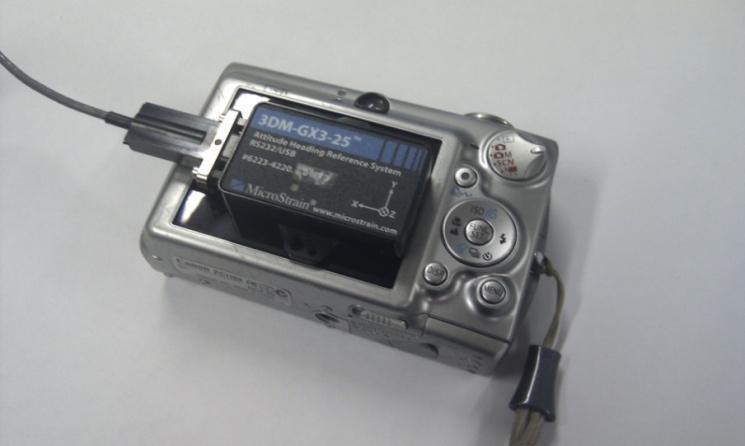
10 Data collection Data collected on ground floor of Nottingham Geospatial Building HP laptop with Wi-Fi Netstumbler for Wi-Fi data collection Foot mounted IMU Microstrain 3DM-GX3 USB communication and power Outputs NMEA data Basic Wi-Fi fingerprinting software developed at IESSG

11 Signal strength for one AP Signal strength to AP 00:23:33:16:3C:90 >-40dB -40 to -50dB -50 to -60dB -60 to -70dB -70 to -80dB < -80dB
12 Basic Wi-Fi fingerprinting
13 Wi-Fi fingerprinting Works better indoors where walls/ceilings/furniture will attenuate signals the most i.e. Accuracy comes from signal strength varying spatially Advanced algorithms Particle filtering How do we build databases? Skyhook use fleet of vehicles with GPS (tribe sourcing) Google use crowd sourcing(?) But what about inside where GPS isn t working? Slow database generation using building plans Scalability? How do we keep the database up-to-date?
14 2. Inertial navigation
15 Inertial navigation GPS Microphone Wi-Fi Ambient light sensor 3G/GPRS 3-axis accelerometer Bluetooth Proximity sensor 3-axis gyro FM radio 3-axis magnetometer Camera


 Better")

16 Inertial Navigation 3 gyros and 3 accelerometers Orientation from integrating gyros Displacement from rotating measurements to Earth frame (using gyros), removing gravity and double integrating accelerometers Not very accurate! MEMS getting better Cheaper (higher volumes e.g. Wii, smartphones) Better manufacturing Calibration Successful results usually from Good sensors Integration with GPS, magnetometers, zero velocity, Step detection algorithms
17
18 Inertial Navigation Time (s) Horiz error (m)
19 3. Computer Vision + Inertial + GPS
20 Computer Vision + Inertial Navigation GPS Microphone Wi-Fi Ambient light sensor 3G/GPRS 3-axis accelerometer Bluetooth Proximity sensor 3-axis gyro FM radio 3-axis magnetometer Camera


21 Concept: Video Aided Inertial Successive images used to compute direction camera is moving Used to correct IMU drift
22 Computer Vision Ground plane Homography algorithm Single camera looking at plane Compute rotation and translation between images t 1

 Red")
23 Examples... Computer Vision Blue (inlier correspondences) Red (outlier correspondences)


24 Integration INS corrections IMU Rotation, Acceleration INS Position, Velocity, Attitude Kalman filter Ranges, Ephemeris Position, Velocity GPS PVT computation Camera Image Computer Vision Translation

25 Experiment GPS Power
26
27
28 Position accuracy Time (s) Horiz error (m)
29 GPS+IMU+Vision Advantages Good position accuracy Makes use of sensors already on smartphones Handheld Works with or without GPS Disadvantages Needs to be initialised e.g. with GPS Not tested with real smartphones (yet) Problems in low light conditions Computationally expensive
30 4. Other research
31 Other research GPS Microphone Wi-Fi Ambient light sensor 3G/GPRS 3-axis accelerometer Bluetooth Proximity sensor 3-axis gyro FM radio 3-axis magnetometer Maps Camera
 Walls and doors constrain user motion Direction of")
32 Magnetometers Other research Total magnetic field varies spatially Image matching (image bag-of-words) Build database of images and locations (like Wi-Fi) Search for an image match to get location Map matching Already used for inertial and Wi-Fi (particle filtering) Walls and doors constrain user motion Direction of travel
33 Conclusions Identified some promising technologies for navigation GPS, Wi-Fi, gyros, accelerometers, magnetometers, cameras, maps sensors already available on smartphones (although not necessarily that accurate) non-dedicated infrastructure positioning e.g. Wi-Fi, images, magnetic field what else? Other sensors? needs a strong case to appear on a smartphone e.g. NFC Integration solution will comprise of several technologies? use inertial navigation to combine together?
34 Chris Hide IESSG, University of Nottingham, UK
Testing the Possibilities of Using IMUs with Different Types of Movements
 137 Testing the Possibilities of Using IMUs with Different Types of Movements Kajánek, P. and Kopáčik A. Slovak University of Technology, Faculty of Civil Engineering, Radlinského 11, 81368 Bratislava,
3DM-GX5-25 Attitude Heading Reference System (AHRS)
") LORD QUICK START GUIDE 3DM-GX5-25 Attitude Heading Reference System (AHRS) The 3DM - GX5-25 is a high- performance, industrial- grade Attitude Heading Reference System (AHRS) that combines micro inertial
LORD QUICK START GUIDE 3DM-GX5-25 Attitude Heading Reference System (AHRS) The 3DM - GX5-25 is a high- performance, industrial- grade Attitude Heading Reference System (AHRS) that combines micro inertial
ROTATING IMU FOR PEDESTRIAN NAVIGATION
 ROTATING IMU FOR PEDESTRIAN NAVIGATION ABSTRACT Khairi Abdulrahim Faculty of Science and Technology Universiti Sains Islam Malaysia (USIM) Malaysia A pedestrian navigation system using a low-cost inertial
Satellite and Inertial Navigation and Positioning System
 Satellite and Inertial Navigation and Positioning System Project Proposal By: Luke Pfister Dan Monroe Project Advisors: Dr. In Soo Ahn Dr. Yufeng Lu EE 451 Senior Capstone Project December 10, 2009 PROJECT
navigation Isaac Skog
 Foot-mounted zerovelocity aided inertial navigation Isaac Skog skog@kth.se Course Outline 1. Foot-mounted inertial navigation a. Basic idea b. Pros and cons 2. Inertial navigation a. The inertial sensors
Autonomous Navigation for Flying Robots
 Computer Vision Group Prof. Daniel Cremers Autonomous Navigation for Flying Robots Lecture 3.2: Sensors Jürgen Sturm Technische Universität München Sensors IMUs (inertial measurement units) Accelerometers
Camera Drones Lecture 2 Control and Sensors
 Camera Drones Lecture 2 Control and Sensors Ass.Prof. Friedrich Fraundorfer WS 2017 1 Outline Quadrotor control principles Sensors 2 Quadrotor control - Hovering Hovering means quadrotor needs to hold
Fusing Sensors into Mobile Operating Systems & Innovative Use Cases
 Fusing Sensors into Mobile Operating Systems & Innovative Use Cases May 23, 2012 Tristan Joo (tristanjoo@wca.org) Board Director & Co-Chair of Mobile SIG Wireless Communications Alliance, Independent Executive
Satellite Attitude Determination
 Satellite Attitude Determination AERO4701 Space Engineering 3 Week 5 Last Week Looked at GPS signals and pseudorange error terms Looked at GPS positioning from pseudorange data Looked at GPS error sources,
Navigational Aids 1 st Semester/2007/TF 7:30 PM -9:00 PM
 Glossary of Navigation Terms accelerometer. A device that senses inertial reaction to measure linear or angular acceleration. In its simplest form, it consists of a case-mounted spring and mass arrangement
Low Cost solution for Pose Estimation of Quadrotor
 Low Cost solution for Pose Estimation of Quadrotor mangal@iitk.ac.in https://www.iitk.ac.in/aero/mangal/ Intelligent Guidance and Control Laboratory Indian Institute of Technology, Kanpur Mangal Kothari
Public Sensing Using Your Mobile Phone for Crowd Sourcing
 Institute of Parallel and Distributed Systems () Universitätsstraße 38 D-70569 Stuttgart Public Sensing Using Your Mobile Phone for Crowd Sourcing 55th Photogrammetric Week September 10, 2015 Stuttgart,
CHARACTERIZATION AND CALIBRATION OF MEMS INERTIAL MEASUREMENT UNITS
 CHARACTERIZATION AND CALIBRATION OF MEMS INERTIAL MEASUREMENT UNITS ökçen Aslan 1,2, Afşar Saranlı 2 1 Defence Research and Development Institute (SAE), TÜBİTAK 2 Dept. of Electrical and Electronics Eng.,
E80. Experimental Engineering. Lecture 9 Inertial Measurement
 Lecture 9 Inertial Measurement http://www.volker-doormann.org/physics.htm Feb. 19, 2013 Christopher M. Clark Where is the rocket? Outline Sensors People Accelerometers Gyroscopes Representations State
Selection and Integration of Sensors Alex Spitzer 11/23/14
 Selection and Integration of Sensors Alex Spitzer aes368@cornell.edu 11/23/14 Sensors Perception of the outside world Cameras, DVL, Sonar, Pressure Accelerometers, Gyroscopes, Magnetometers Position vs
XDK HARDWARE OVERVIEW
 XDK HARDWARE OVERVIEW Agenda 1 General Overview 2 3 4 Sensors Communications Extension Board 2 General Overview 1. General Overview What is the XDK? The Cross-Domain Development Kit, or XDK, is a battery
DriftLess Technology to improve inertial sensors
 Slide 1 of 19 DriftLess Technology to improve inertial sensors Marcel Ruizenaar, TNO marcel.ruizenaar@tno.nl Slide 2 of 19 Topics Problem, Drift in INS due to bias DriftLess technology What is it How it
Error Simulation and Multi-Sensor Data Fusion
 Error Simulation and Multi-Sensor Data Fusion AERO4701 Space Engineering 3 Week 6 Last Week Looked at the problem of attitude determination for satellites Examined several common methods such as inertial
Inertial Navigation Systems
 Inertial Navigation Systems Kiril Alexiev University of Pavia March 2017 1 /89 Navigation Estimate the position and orientation. Inertial navigation one of possible instruments. Newton law is used: F =
GNSS/INS for High Accuracy Mobile Mapping. Olaf Gross 11 th Terrasolid European User Event Kittilä, Finland
 GNSS/INS for High Accuracy Mobile Mapping Olaf Gross 11 th Terrasolid European User Event 15.02.2012 Kittilä, Finland IGI mbh Founded 1978 25 staff about half in R&D More than 380 customers in 60 different
Inertial Systems. Ekinox Series TACTICAL GRADE MEMS. Motion Sensing & Navigation IMU AHRS MRU INS VG
 Ekinox Series TACTICAL GRADE MEMS Inertial Systems IMU AHRS MRU INS VG ITAR Free 0.05 RMS Motion Sensing & Navigation AEROSPACE GROUND MARINE Ekinox Series R&D specialists usually compromise between high
Introduction to Inertial Navigation (INS tutorial short)
") Introduction to Inertial Navigation (INS tutorial short) Note 1: This is a short (20 pages) tutorial. An extended (57 pages) tutorial that also includes Kalman filtering is available at http://www.navlab.net/publications/introduction_to
Introduction to Inertial Navigation (INS tutorial short) Note 1: This is a short (20 pages) tutorial. An extended (57 pages) tutorial that also includes Kalman filtering is available at http://www.navlab.net/publications/introduction_to
Associate Professor Tao Gu, RMIT University, Australia INDOOR POSITIONING VIA SMARTPHONE SENSING
 Associate Professor Tao Gu, RMIT University, Australia INDOOR POSITIONING VIA SMARTPHONE SENSING Outline Indoor Localization using smartphone magnetometer Floor localization Localization in Metro Trains
Simulation of GNSS/IMU Measurements. M. J. Smith, T. Moore, C. J. Hill, C. J. Noakes, C. Hide
 Simulation of GNSS/IMU Measurements M. J. Smith, T. Moore, C. J. Hill, C. J. Noakes, C. Hide Institute of Engineering Surveying and Space Geodesy (IESSG) The University of Nottingham Keywords: Simulation,
Camera and Inertial Sensor Fusion
 January 6, 2018 For First Robotics 2018 Camera and Inertial Sensor Fusion David Zhang david.chao.zhang@gmail.com Version 4.1 1 My Background Ph.D. of Physics - Penn State Univ. Research scientist at SRI
INTEGRATED TECH FOR INDUSTRIAL POSITIONING
 INTEGRATED TECH FOR INDUSTRIAL POSITIONING Integrated Tech for Industrial Positioning aerospace.honeywell.com 1 Introduction We are the world leader in precision IMU technology and have built the majority
MEMS technology quality requirements as applied to multibeam echosounder. Jerzy DEMKOWICZ, Krzysztof BIKONIS
 MEMS technology quality requirements as applied to multibeam echosounder Jerzy DEMKOWICZ, Krzysztof BIKONIS Gdansk University of Technology Gdansk, Narutowicza str. 11/12, Poland demjot@eti.pg.gda.pl Small,
IMU and Encoders. Team project Robocon 2016
 IMU and Encoders Team project Robocon 2016 Harsh Sinha, 14265, harshsin@iitk.ac.in Deepak Gangwar, 14208, dgangwar@iitk.ac.in Swati Gupta, 14742, swatig@iitk.ac.in March 17 th 2016 IMU and Encoders Module
GPS denied Navigation Solutions
 GPS denied Navigation Solutions Krishnraj Singh Gaur and Mangal Kothari ksgaur@iitk.ac.in, mangal@iitk.ac.in https://www.iitk.ac.in/aero/mangal/ Intelligent Guidance and Control Laboratory Indian Institute
Calibration of Inertial Measurement Units Using Pendulum Motion
 Technical Paper Int l J. of Aeronautical & Space Sci. 11(3), 234 239 (2010) DOI:10.5139/IJASS.2010.11.3.234 Calibration of Inertial Measurement Units Using Pendulum Motion Keeyoung Choi* and Se-ah Jang**
DYNAMIC POSITIONING CONFERENCE September 16-17, Sensors
 DYNAMIC POSITIONING CONFERENCE September 16-17, 2003 Sensors An Integrated acoustic positioning and inertial navigation system Jan Erik Faugstadmo, Hans Petter Jacobsen Kongsberg Simrad, Norway Revisions
DEVELOPMENT OF A PEDESTRIAN INDOOR NAVIGATION SYSTEM BASED ON MULTI-SENSOR FUSION AND FUZZY LOGIC ESTIMATION ALGORITHMS
 The International Archives of the Photogrammetry, Remote Sensing and Spatial Information Sciences, Volume XL-4/W5, 215 Indoor-Outdoor Seamless Modelling, Mapping and Navigation, 21 22 May 215, Tokyo, Japan
GPS + Inertial Sensor Fusion
 GPS + Inertial Sensor Fusion Senior Project Proposal Aleksey Lykov, William Tarpley, Anton Volkov Advisors: Dr. In Soo Ahn, Dr. Yufeng Lu Date: November 26, 2013 Project Summary The objective of this project
GNSS-aided INS for land vehicle positioning and navigation
 Thesis for the degree of Licentiate of Engineering GNSS-aided INS for land vehicle positioning and navigation Isaac Skog Signal Processing School of Electrical Engineering KTH (Royal Institute of Technology)
COMBINING MEMS-BASED IMU DATA AND VISION-BASED TRAJECTORY ESTIMATION
 COMBINING MEMS-BASED IMU DATA AND VISION-BASED TRAJECTORY ESTIMATION F. Tsai a*, H. Chang b and A. Y. S. Su c a Center for Space and Remote Sensing Research b Department of Civil Engineering c Research
Embedded Navigation Solutions VN-100 User Manual
 Embedded Navigation Solutions VN-100 User Manual Firmware v2.1.0.0 Document Revision 2.23 UM001 1 Document Information Title VN-100 User Manual Subtitle Inertial Navigation Modules Document Type User Manual
An Intro to Gyros. FTC Team #6832. Science and Engineering Magnet - Dallas ISD
 An Intro to Gyros FTC Team #6832 Science and Engineering Magnet - Dallas ISD Gyro Types - Mechanical Hubble Gyro Unit Gyro Types - Sensors Low cost MEMS Gyros High End Gyros Ring laser, fiber optic, hemispherical
3D Motion Tracking by Inertial and Magnetic sensors with or without GPS
 3D Motion Tracking by Inertial and Magnetic sensors with or without GPS Junping Cai M.Sc. E. E, PhD junping@mci.sdu.dk Centre for Product Development (CPD) Mads Clausen Institute (MCI) University of Southern
EE565:Mobile Robotics Lecture 2
 EE565:Mobile Robotics Lecture 2 Welcome Dr. Ing. Ahmad Kamal Nasir Organization Lab Course Lab grading policy (40%) Attendance = 10 % In-Lab tasks = 30 % Lab assignment + viva = 60 % Make a group Either
TEST RESULTS OF A GPS/INERTIAL NAVIGATION SYSTEM USING A LOW COST MEMS IMU
 TEST RESULTS OF A GPS/INERTIAL NAVIGATION SYSTEM USING A LOW COST MEMS IMU Alison K. Brown, Ph.D.* NAVSYS Corporation, 1496 Woodcarver Road, Colorado Springs, CO 891 USA, e-mail: abrown@navsys.com Abstract
MIP Inertial Sensors with Magnetometers Hard and Soft Iron Calibration Software
 LORD QUICK START GUIDE MIP Inertial Sensors with Magnetometers Hard and Soft Iron Calibration Software Overview Certain MIP inertial sensors contain a magnetometer. The magnetometer values are available
EE 570: Location and Navigation: Theory & Practice
 EE 570: Location and Navigation: Theory & Practice Navigation Sensors and INS Mechanization Thursday 14 Feb 2013 NMT EE 570: Location and Navigation: Theory & Practice Slide 1 of 14 Inertial Sensor Modeling
A High Precision Reference Data Set for Pedestrian Navigation using Foot-Mounted Inertial Sensors
 200 International Conference on Indoor Positioning and Indoor Navigation (IPIN), 5-7 September 200, Zürich, Switzerland A High Precision Reference Data Set for Pedestrian Navigation using Foot-Mounted
3DM-GQ4-45 Tactical Grade GNSS-Aided Inertial Navigation System (GNSS/INS)
") LORD QUICK START GUIDE 3DM-GQ4-45 Tactical Grade GNSS-Aided Inertial Navigation System (GNSS/INS) The 3DM-GQ4-45 is a high-performance, GNSS-Aided Inertial Navigation System (GNSS/INS) that combines micro
LORD QUICK START GUIDE 3DM-GQ4-45 Tactical Grade GNSS-Aided Inertial Navigation System (GNSS/INS) The 3DM-GQ4-45 is a high-performance, GNSS-Aided Inertial Navigation System (GNSS/INS) that combines micro
UJIINDOORLOC - A NEW MULTI-BUILDING AND MULTI- FLOOR DATABASE FOR WLAN FINGERPRINT-BASED INDOOR LOCALIZATION PROBLEMS
 UJIINDOORLOC - A NEW MULTI-BUILDING AND MULTI- FLOOR DATABASE FOR WLAN FINGERPRINT-BASED INDOOR LOCALIZATION PROBLEMS Carried out by Joaquín Torres-Sospedra et al. at 2 Spanish universities. Largest &
ECV ecompass Series. Technical Brief. Rev A. Page 1 of 8. Making Sense out of Motion
 Technical Brief The ECV ecompass Series provides stable azimuth, pitch, and roll measurements in dynamic conditions. An enhanced version of our ECG Series, the ECV includes a full suite of precision, 3-axis,
GEOENGINE M.Sc. in Geomatics Engineering. Master Thesis by Jiny Jose Pullamthara
 GEOENGINE M.Sc. in Geomatics Engineering Master Thesis by Jiny Jose Pullamthara Implementation of GNSS in Real-Time Positioning for an Outdoor Construction Machine Simulator Duration of Thesis : 6 months
Dealing with Scale. Stephan Weiss Computer Vision Group NASA-JPL / CalTech
 Dealing with Scale Stephan Weiss Computer Vision Group NASA-JPL / CalTech Stephan.Weiss@ieee.org (c) 2013. Government sponsorship acknowledged. Outline Why care about size? The IMU as scale provider: The
Aided-inertial for Long-term, Self-contained GPS-denied Navigation and Mapping
 Aided-inertial for Long-term, Self-contained GPS-denied Navigation and Mapping Erik Lithopoulos, Louis Lalumiere, Ron Beyeler Applanix Corporation Greg Spurlock, LTC Bruce Williams Defense Threat Reduction
Collaboration is encouraged among small groups (e.g., 2-3 students).
.") Assignments Policies You must typeset, choices: Word (very easy to type math expressions) Latex (very easy to type math expressions) Google doc Plain text + math formula Your favorite text/doc editor Submit
Assignments Policies You must typeset, choices: Word (very easy to type math expressions) Latex (very easy to type math expressions) Google doc Plain text + math formula Your favorite text/doc editor Submit
Perspective Sensing for Inertial Stabilization
 Perspective Sensing for Inertial Stabilization Dr. Bernard A. Schnaufer Jeremy Nadke Advanced Technology Center Rockwell Collins, Inc. Cedar Rapids, IA Agenda Rockwell Collins & the Advanced Technology
Strapdown Inertial Navigation Technology
 Strapdown Inertial Navigation Technology 2nd Edition David Titterton and John Weston The Institution of Engineering and Technology Preface xv 1 Introduction 1 1.1 Navigation 1 1.2 Inertial navigation 2
Embedded Navigation Solutions. VN-100 User Manual. Firmware v Document Revision UM001 Introduction 1
 Embedded Navigation Solutions VN-100 User Manual Firmware v2.1.0.0 Document Revision 2.41 UM001 Introduction 1 Document Information Title VN-100 User Manual Subtitle Inertial Navigation Modules Document
Using SensorTag as a Low-Cost Sensor Array for AutoCAD
 Using SensorTag as a Low-Cost Sensor Array for AutoCAD Kean Walmsley Autodesk SD5013 In 2012 Texas Instruments Inc. launched the SensorTag, a $25 sensor array that communicates via Bluetooth Smart (also
Motion-sensing Devices in the Assistive Technology Arena
 Motion-sensing Devices in the Assistive Technology Arena Owen R. Edwards, MEng Rehabilitation Engineering Research Fellow, Smith-Kettlewell Eye Research Institute & Bioengineer, Stanford University School
Inertial Navigation Static Calibration
 INTL JOURNAL OF ELECTRONICS AND TELECOMMUNICATIONS, 2018, VOL. 64, NO. 2, PP. 243 248 Manuscript received December 2, 2017; revised April, 2018. DOI: 10.24425/119518 Inertial Navigation Static Calibration
9 Degrees of Freedom Inertial Measurement Unit with AHRS [RKI-1430]
![9 Degrees of Freedom Inertial Measurement Unit with AHRS [RKI-1430]](/thumbs/86/94257860.jpg "9 Degrees of Freedom Inertial Measurement Unit with AHRS [RKI-1430]") 9 Degrees of Freedom Inertial Measurement Unit with AHRS [RKI-1430] Users Manual Robokits India info@robokits.co.in http://www.robokitsworld.com Page 1 This 9 Degrees of Freedom (DOF) Inertial Measurement
9 Degrees of Freedom Inertial Measurement Unit with AHRS [RKI-1430] Users Manual Robokits India info@robokits.co.in http://www.robokitsworld.com Page 1 This 9 Degrees of Freedom (DOF) Inertial Measurement
Bluetooth Embedded Inertial Measurement Unit for Real-Time Data Collection for Gait Analysis
 Bluetooth Embedded Inertial Measurement Unit for Real-Time Data Collection for Gait Analysis Ravi Chandrasiri Sri Lanka Institute of Information Technology Colombo, Sri Lanka ravi.chandrasiri@gmail.com
Strapdown Inertial Navigation Technology, Second Edition D. H. Titterton J. L. Weston
 Strapdown Inertial Navigation Technology, Second Edition D. H. Titterton J. L. Weston NavtechGPS Part #1147 Progress in Astronautics and Aeronautics Series, 207 Published by AIAA, 2004, Revised, 2nd Edition,
Acceleration Data Correction of an Inertial Navigation Unit Using Turntable Test Bed
 Proceedings of the World Congress on Electrical Engineering and Computer Systems and Science (EECSS 2015) Barcelona, Spain July 13-14, 2015 Paper No. 149 Acceleration Data Correction of an Inertial Navigation
Satellite/Inertial Navigation and Positioning System (SINAPS)
") Satellite/Inertial Navigation and Positioning System (SINAPS) Functional Requirements List and Performance Specifications by Daniel Monroe, Luke Pfister Advised By Drs. In Soo Ahn and Yufeng Lu ECE Department
Satellite/Inertial Navigation and Positioning System (SINAPS) Functional Requirements List and Performance Specifications by Daniel Monroe, Luke Pfister Advised By Drs. In Soo Ahn and Yufeng Lu ECE Department
EMBEDDED SYSTEMS PROGRAMMING Accessing Hardware
 EMBEDDED SYSTEMS PROGRAMMING 2016-17 Accessing Hardware HARDWARE LIST Accelerometer Vector magnetometer (compass) Gyroscope GPS and/or other location facilities (Front/rear) camera Microphone Speaker Battery
Inertial Measurement Units I!
 ! Inertial Measurement Units I! Gordon Wetzstein! Stanford University! EE 267 Virtual Reality! Lecture 9! stanford.edu/class/ee267/!! Lecture Overview! coordinate systems (world, body/sensor, inertial,
Exterior Orientation Parameters
 Exterior Orientation Parameters PERS 12/2001 pp 1321-1332 Karsten Jacobsen, Institute for Photogrammetry and GeoInformation, University of Hannover, Germany The georeference of any photogrammetric product
Me 3-Axis Accelerometer and Gyro Sensor
 Me 3-Axis Accelerometer and Gyro Sensor SKU: 11012 Weight: 20.00 Gram Description: Me 3-Axis Accelerometer and Gyro Sensor is a motion processing module. It can use to measure the angular rate and the
MULTI-SENSOR DATA FUSION FOR LAND VEHICLE ATTITUDE ESTIMATION USING A FUZZY EXPERT SYSTEM
 Data Science Journal, Volume 4, 28 November 2005 127 MULTI-SENSOR DATA FUSION FOR LAND VEHICLE ATTITUDE ESTIMATION USING A FUZZY EXPERT SYSTEM Jau-Hsiung Wang* and Yang Gao Department of Geomatics Engineering,
MULTI-MODAL MAPPING. Robotics Day, 31 Mar Frank Mascarich, Shehryar Khattak, Tung Dang
 MULTI-MODAL MAPPING Robotics Day, 31 Mar 2017 Frank Mascarich, Shehryar Khattak, Tung Dang Application-Specific Sensors Cameras TOF Cameras PERCEPTION LiDAR IMU Localization Mapping Autonomy Robotic Perception
Handout. and. brief description. Marine Gravity Meter KSS 32- M
 and brief description of Marine Gravity Meter KSS 32- M Copyright 1999-2010 Bodensee Gravitymeter Geosystem GmbH All rights reserved 1 KSS32-M Marine Gravity Meter Cover removed Copyright 1999-2010 Bodensee
Dynamic Modelling for MEMS-IMU/Magnetometer Integrated Attitude and Heading Reference System
 International Global Navigation Satellite Systems Society IGNSS Symposium 211 University of New South Wales, Sydney, NSW, Australia 15 17 November, 211 Dynamic Modelling for MEMS-IMU/Magnetometer Integrated
Tracking driver actions and guiding phone usage for safer driving. Hongyu Li Jan 25, 2018
 Tracking driver actions and guiding phone usage for safer driving Hongyu Li Jan 25, 2018 1 Smart devices risks and opportunities Phone in use 14% Other distractions 86% Distraction-Affected Fatalities
Parallax LSM9DS1 9-axis IMU Module (#28065)
") Web Site: www.parallax.com Forums: forums.parallax.com Sales: sales@parallax.com Technical:support@parallax.com Office: (916) 624-8333 Fax: (916) 624-8003 Sales: (888) 512-1024 Tech Support: (888) 997-8267
Web Site: www.parallax.com Forums: forums.parallax.com Sales: sales@parallax.com Technical:support@parallax.com Office: (916) 624-8333 Fax: (916) 624-8003 Sales: (888) 512-1024 Tech Support: (888) 997-8267
Cross-Domain Development Kit XDK110 Platform for Application Development
 Sensor Guide Cross-Domain Development Kit Platform for Application Development Bosch Connected Devices and Solutions : Data Sheet Document revision 2.1 Document release date 05.10.17 Workbench version
The BOM [Broadcasting Outer Module]
![The BOM [Broadcasting Outer Module]](/thumbs/91/106681333.jpg "The BOM [Broadcasting Outer Module]") Avionics Reimagined The BOM [Broadcasting Outer Module] The first and only ALL-IN-ONE AVIONICS SUITE Distributed by: Adams Aviation Supply Co Ltd mail@adamsaviation.com www.adamsaviation.com BOM (Broadcasting
Avionics Reimagined The BOM [Broadcasting Outer Module] The first and only ALL-IN-ONE AVIONICS SUITE Distributed by: Adams Aviation Supply Co Ltd mail@adamsaviation.com www.adamsaviation.com BOM (Broadcasting
Orientation Capture of a Walker s Leg Using Inexpensive Inertial Sensors with Optimized Complementary Filter Design
 Orientation Capture of a Walker s Leg Using Inexpensive Inertial Sensors with Optimized Complementary Filter Design Sebastian Andersson School of Software Engineering Tongji University Shanghai, China
Ubiquitous IoT Perspectives The Power of Connected Sensors and Actuators
 Ubiquitous IoT Perspectives The Power of Connected Sensors and Actuators Andrea Onetti Vice President, General Manager MEMS Sensor Division STMicroelectronics Digital Technologies are Transforming nearly
ABSTRACT ROBOT LOCALIZATION USING INERTIAL AND RF SENSORS. by Aleksandr Elesev
 ABSTRACT ROBOT LOCALIZATION USING INERTIAL AND RF SENSORS by Aleksandr Elesev A mobile robot must know its position in order to operate autonomously. The process of determining the robot s position from
Vehicle s Kinematics Measurement with IMU
 536441 Vehicle dnamics and control laborator Vehicle s Kinematics Measurement with IMU This laborator is design to introduce ou to understand and acquire the inertia properties for using in the vehicle
MOBILE COMPUTING 2/13/18. Mobile Sensing. Sensors & Sensing. CSE 40814/60814 Spring 2018
 MOBILE COMPUTING CSE 40814/60814 Spring 2018 Mobile Sensing Smartphones (and tablets, etc.) not only serve as a key computing and communication device, but also come with a rich set of embedded sensors
Relating Local Vision Measurements to Global Navigation Satellite Systems Using Waypoint Based Maps
 Relating Local Vision Measurements to Global Navigation Satellite Systems Using Waypoint Based Maps John W. Allen Samuel Gin College of Engineering GPS and Vehicle Dynamics Lab Auburn University Auburn,
ADVANTAGES OF INS CONTROL SYSTEMS
 ADVANTAGES OF INS CONTROL SYSTEMS Pavol BOŽEK A, Aleksander I. KORŠUNOV B A Institute of Applied Informatics, Automation and Mathematics, Faculty of Material Science and Technology, Slovak University of
Towards multi-layer pedestrian behaviour maps for simulation, tracking, interpretation and indoor navigation
 Towards multi-layer pedestrian behaviour maps for simulation, tracking, interpretation and indoor navigation A. Borrmann 1, M. Butenuth 2, S. Chakraborty 3, A. Kneidl 2, M. Schäfer 3 Technische Universität
Lecture 13 Visual Inertial Fusion
 Lecture 13 Visual Inertial Fusion Davide Scaramuzza Course Evaluation Please fill the evaluation form you received by email! Provide feedback on Exercises: good and bad Course: good and bad How to improve
Test Report iµvru. (excerpt) Commercial-in-Confidence. imar Navigation GmbH Im Reihersbruch 3 D St. Ingbert Germany.
 Commercial-in-Confidence. imar Navigation GmbH Im Reihersbruch 3 D St. Ingbert Germany.") 1 of 11 (excerpt) Commercial-in-Confidence imar Navigation GmbH Im Reihersbruch 3 D-66386 St. Ingbert Germany www.imar-navigation.de sales@imar-navigation.de 2 of 11 CHANGE RECORD Date Issue Paragraph
1 of 11 (excerpt) Commercial-in-Confidence imar Navigation GmbH Im Reihersbruch 3 D-66386 St. Ingbert Germany www.imar-navigation.de sales@imar-navigation.de 2 of 11 CHANGE RECORD Date Issue Paragraph
A method of personal positioning based on sensor data fusion of wearable camera and self-contained sensors
 A method of personal positioning based on sensor data fusion of wearable camera and self-contained sensors Masakatsu Kourogi Takeshi Kurata Intelligent Systems Institute, National Institute of Advanced
Promoting the Use of Accessible Mobile Technologies for the Workplace Way finding Technologies
 Promoting the Use of Accessible Mobile Technologies for the Workplace Way finding Technologies John Sanchez, Research Architect, IBM Human Ability and Accessibility Center June 2014 Accessible Location
APN-065: Determining Rotations for Inertial Explorer and SPAN
 APN-065 Rev A APN-065: Determining Rotations for Inertial Explorer and SPAN Page 1 May 5, 2014 Both Inertial Explorer (IE) and SPAN use intrinsic -order Euler angles to define the rotation between the
Strap-Down Pedestrian Dead-Reckoning System
 Strap-Down Pedestrian Dead-Reckoning System Pragun Goyal, Vinay J. Ribeiro, Huzur Saran and Anshul Kumar Department of Computer Science and Engineering Indian Institute of Technology Delhi, New Delhi 1116
Sensor Integration and Image Georeferencing for Airborne 3D Mapping Applications
 Sensor Integration and Image Georeferencing for Airborne 3D Mapping Applications By Sameh Nassar and Naser El-Sheimy University of Calgary, Canada Contents Background INS/GPS Integration & Direct Georeferencing
StreetMapper 360 & StreetMapper Portable
 StreetMapper 360 & StreetMapper Portable 11th February 2010 Dr. Chris Cox & Mr. Olaf Gross 3D Laser Mapping LIDAR Specialists StreetMapper Distributor for RIEGL (UK, Ireland, Southern Africa) Terrasolid
LibrePilot GCS Tutorial
 LibrePilot GCS Tutorial BY Wirginia Tomczyk page 1 of 13 Introduction The first dron of Drone Team project use Open Pilot Copter Control (CC). It is the flight controller supported by LibrePilot firmware.
Overview. EECS 124, UC Berkeley, Spring 2008 Lecture 23: Localization and Mapping. Statistical Models
 Introduction ti to Embedded dsystems EECS 124, UC Berkeley, Spring 2008 Lecture 23: Localization and Mapping Gabe Hoffmann Ph.D. Candidate, Aero/Astro Engineering Stanford University Statistical Models
Linear/Rotary Hexapod Actuators with IMU8420 Motion Capture and Real Time Simulator Tools
 Linear/Rotary Hexapod Actuators with IMU8420 Motion Capture and Real Time Simulator Tools Preliminary Overview www.soc-robotics.com Copyright 2013. SOC Robotics, Inc. 1 Version 1.00 Introducing a low-cost
Stable Vision-Aided Navigation for Large-Area Augmented Reality
 Stable Vision-Aided Navigation for Large-Area Augmented Reality Taragay Oskiper, Han-Pang Chiu, Zhiwei Zhu Supun Samarasekera, Rakesh Teddy Kumar Vision and Robotics Laboratory SRI-International Sarnoff,
Sensor Fusion: Potential, Challenges and Applications. Presented by KVH Industries and Geodetics, Inc. December 2016
 Sensor Fusion: Potential, Challenges and Applications Presented by KVH Industries and Geodetics, Inc. December 2016 1 KVH Industries Overview Innovative technology company 600 employees worldwide Focused
The Applanix Approach to GPS/INS Integration
 Lithopoulos 53 The Applanix Approach to GPS/INS Integration ERIK LITHOPOULOS, Markham ABSTRACT The Position and Orientation System for Direct Georeferencing (POS/DG) is an off-the-shelf integrated GPS/inertial
7 3-Sep Localization and Navigation (GPS, INS, & SLAM) 8 10-Sep State-space modelling & Controller Design 9 17-Sep Vision-based control
 8 10-Sep State-space modelling & Controller Design 9 17-Sep Vision-based control") RoboticsCourseWare Contributor 2012 School of Information Technology and Electrical Engineering at the University of Queensland Schedule Week Date Lecture (M: 12-1:30, 43-102) 1 23-Jul Introduction Representing
RoboticsCourseWare Contributor 2012 School of Information Technology and Electrical Engineering at the University of Queensland Schedule Week Date Lecture (M: 12-1:30, 43-102) 1 23-Jul Introduction Representing
Review Paper: Inertial Measurement
 Review Paper: Inertial Measurement William T. Conlin (wtconlin@gmail.com) arxiv:1708.04325v1 [cs.ro] 8 Aug 2017 May 2017 Abstract Applications of inertial measurement units are extremely diverse, and are
Game Application Using Orientation Sensor
 IOSR Journal of Engineering (IOSRJEN) ISSN (e): 2250-3021, ISSN (p): 2278-8719 Vol. 04, Issue 01 (January. 2014), V4 PP 46-50 www.iosrjen.org Game Application Using Orientation Sensor Soon-kak Kwon, Won-serk
OFERTA O120410PA CURRENT DATE 10/04//2012 VALID UNTIL 10/05/2012 SUMMIT XL
 OFERTA O120410PA CURRENT DATE 10/04//2012 VALID UNTIL 10/05/2012 SUMMIT XL CLIENT CLIENT: Gaitech REPRESENTANT: Andrew Pether MAIL: andyroojp@hotmail.com PRODUCT Introduction The SUMMIT XL has skid-steering
A Pedestrian Navigation System Based On a Foot-Mounted IMU and Map Constraints. Dan Pierce and Dr. David Bevly
 A Pedestrian Navigation System Based On a Foot-Mounted IMU and Map Constraints Dan Pierce and Dr. David Bevly Outline Motivation/Introduction System Description Localization Foot-mounted IMU algorithm