GeoMax GNSS ZGP800 Series. Works when you do
|
|
|
- Ambrose Stevenson
- 5 years ago
- Views:
Transcription


1 GeoMax GNSS ZGP800 Series Works when you do


2 GeoMax About Us GeoMax is an internationally active company developing, manufacturing and distributing quality surveying instruments. We provide a comprehensive portfolio of integrated instruments for the surveying, mapping and construction industries. Both occasional and professional users are addressed with GeoMax s easy-to-use, yet highly productive, range of Total Stations, GNSS, Lasers, Optical and digital levels. GeoMax is part of the Hexagon Group, Sweden, a global technology group with strong market positions within measurement technologies. Hexagon is the world leader in multidimensional measurements within the macro and micro segments of the measurement and positioning market. The famous international companies within the Hexagon Group have delivered since more than 150 years precision products and solutions to the measurement industry. This technology is supported by a comprehensive sales and service network covering all continents with over 100 branches. The close cooperation within the Hexagon Group grants GeoMax s access to state of the art development and production facilities in Europe, America and Asia. This enables us to focus on delivering products that work when you do by optimizing quality and productivity. Through a continually growing distribution, GeoMax products are available in Europe, Asia, the Middle East, Americas and Africa delivering outstanding price-to-performance. Complete Basket


3 Works when you do! At GeoMax we understand that you work in demanding environments and require excellent price-to-performance without compromising quality, that s why we build products that Work when you do!. With the ever increasing demand to complete projects faster and faster, surveyors are looking for technologies to help them improve their productivity. GNSS is one of the latest technologies that delivers surveyors with a new tool to increase productivity. The GeoMax ZGP800 introduces a GNSS system to surveyors that provides true price-to-performance and takes surveying productivity to the next level! Real-time GNSS Real-time GNSS, also called RTK GNSS, provides surveyors instantly with centimetre coordinates for setout and survey. With GeoMax RTK GNSS planning is easy, you never need to worry about intervisibility, simply setup and start working, even at distances of up to 30 km from the reference station. Easy, yet powerful The ZGP800 sets new standards in ease-of-use without compromising functionality. With a color Windows CE controller, complete with intuitive touch screen functionality users become experts in record time. Using new technology has never been so easy! Complete system GeoMax not only provides you with highly productive equipment, but also with a complete set of accessories to meet your demanding tasks. With everything in one box, GeoMax Works when you do!. Built for all environments With the design criteria Works when you do! GeoMax products are built to withstand all environmental conditions. With robust specifications, the ZGP800 antenna and controller survive topple over falls. Rain, hail, snow or intense heat will never affect your ZGP800, you can always keep working to get the job done. Raw Data Logging With an exceptionally large memory of up to 1 GB, practically endless GNSS raw data can be logged for postprocessing. Upon completion of data collection, the removable CF card can simply be transferred to a PC for postprocessing to deliver the final accurate coordinates. PC-Software GeoMax Geo Office (GGO) provides a complete suite of programs to support your field equipment. With complete flexibility and ease, data can be downloaded, postprocessed and prepared for final CAD processing or direct delivery to clients. Latest Technology


 offers you a wide variety of calculation functions.")


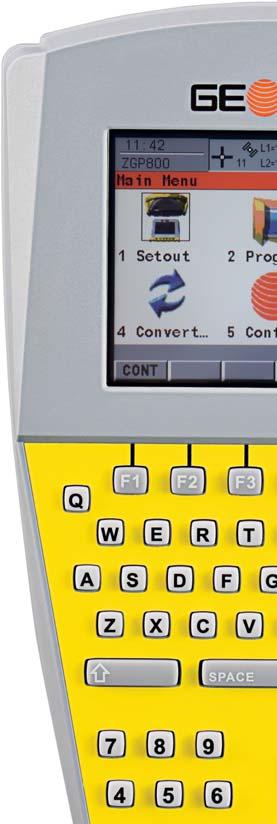
4 Works when you do! At GeoMax we understand that your daily tasks vary greatly, that s why we ve created a number of easy-to-use applications to guide you through every day. With both powerful applications and the latest in technology, you can be certain that GeoMax Works when you do!. Setout No matter if you re using manually entered coordinates, or coordinates read directly from a file, setout has never been so easy. With simple user guidance you ll quickly complete one point and be moving to the next. COGO Routines Coordinate Geometry (COGO) offers you a wide variety of calculation functions. Calculate points that are immediately ready to be staked out by inverse, or intersection using any combination of directions, distances or lines. Complete flexibility ensures that all of your needs are covered. Survey Measure points, lines and areas with ease both with or without code and attribute information. For instant visual confirmation, immediately view measured data in the large graphical map-view display. When both speed and easeof-use are a priority, GeoMax ZGP800 delivers. Reference Line Regardless of whether you re staking or checking a reference line or arc you ll be amazed at the flexibility. Entry of reference objects is simple and can be easily assigned parallel offsets or rotations to exactly meet your demanding needs. Area With complete freedom, you can either measure points, select previously measured points or manually enter points. Whilst creating the area, the perimeter and area of the plan surface is automatically computed. Site calibration & Coordinate Systems The GeoMax ZGP800 provides a simple application to calibrate the system to local site coordinates. For more advanced projects where details of the local coordinate system are provided, a step-by-step routine is available to compute the required transformations to the local coordinate system. Quality Equipped with state-of-the-art NovAtel GNSS technology the ZGP800 provides maximum performance. With built-in Q-Lock technology, all satellites are tracked with the highest possible signal strength and regular independent checks are conducted to ensure that you can work in all environments, no matter how challenging. With imbedded multi-tasking processing, accurate RTK positions are computed automatically, or raw data is logged for postprocessing. No matter how demanding the conditions, you can be sure that your ZGP800 Works when you do!. Communication The ZGP800 integrates modern wireless communication technologies. Bluetooth wirelesstechnology allows cable free communication between the antenna and controller, and also facilitates connectivity to mobile telephones to receive network RTK correction data. Where no regional RTK correction data is available, local RTK correction data is provided with an integrated UHF radio solution. With full flexibility and reliability, GeoMax GNSS has the communication solution to suit your needs. Powerful Applications
5 ZGP800 Series Technical Data Performance Specifications GeoMax Q-Lock technology Cable-free GNSS with Bluetooth wireless-technology integrated on the pole Network capable GNSS 20Hz Positioning rate 72 channel: L1 + L2/L2C GPS L1 + L2 GLONASS SBAS Onboard applications/functions Setout, Survey, COGO, Reference Line, Site Calibration, Determine Coordinate Systems, dxf Import/Export, NMEA output Kinematic surveying Horizontal ± 10 mm + 1 ppm Vertical ± 20 mm + 1 ppm Initialisation time typically 15 seconds Initialisation reliability typically >99.9 % Static and Fast Static surveying Horizontal ± 5 mm ppm Vertical ± 10 mm ppm Code differential GNSS Horizontal/Vertical typically ± 0.25 m Controller Display Colour illuminated ¼ VGA daylight-readable touch screen Operating System Windows CE Communication 3 Bluetooth ports, USB and serial port Storage Removable CF card up to 1 GB, about 7,800 hours L1+L2 data logging at 15 sec rate Data links Radio modem Mobile phone support UHF radio module with fully integrated Bluetooth communications port Transmitting power 0.5 W, 1W Optional 10 W & 35 W reference radio External GSM, GPRS, CDMA modems via Bluetooth communications port Environmental conditions Antenna / Controller Operating / Storage temperature - 30 C ~ + 65 C / - 40 C ~ + 80 C Protection to dust and water IP66 Humidity Up to 100% Power Supply Internal Li-Ion batteries Li-Ion 2.2Ah 7.4V ZGP800A antenna about 5 hours (RTK mode) ZGP800C controller for about 8 hours (RTK mode) External power input 10.5 to 28 V DC Weight Entire RTK rover (incl. controller, batteries, range pole and bracket) 3.07 kg Windows CE is a registered trademark of Microsoft Corporation. The Bluetooth word mark and logos are owned by Bluetooth SIG. NovAtel OnBoard is a registered trademark of NovAtel Inc. Other trademarks and trade names are those of their respective owners. Illustrations, descriptions and technical specifications are not binding and may change. Printed in Switzerland. Copyright GeoMax AG en GeoMax AG info@geomax-positioning.com
GeoMax Total Station Zoom30 Series
 GeoMax Total Station Zoom30 Series GeoMax About Us GeoMax is an internationally active company developing, manufacturing and distributing quality construction and surveying instruments. We provide a comprehensive
GeoMax Total Station Zoom30 Series
 GeoMax Total Station Zoom30 Series GeoMax About Us GeoMax is an internationally nology group with strong mar- The close cooperation within active company developing, ket positions within measure- the Hexagon
GeoMax TPS family. Works when you do.
 Works when you do GeoMax TPS family GeoMax has a complete TPS portfolio to fulfill the needs of all users. Ensure ultimate reliability with GeoMax TPS systems even in challenging environments. Providing
Leica FlexLine TS09plus Full Precision at High Performance
 Leica FlexLine TS09plus Full Precision at High Performance The First Plus: Original Leica Geosystems Quality For most, quality is relative. Not so at Leica Geosystems. To ensure our instruments meet the
Leica FlexLine TS06plus Top Precision meets High Efficiency
 Leica FlexLine TS06plus Top Precision meets High Efficiency The First Plus: Original Leica Geosystems Quality For most, quality is relative. Not so at Leica Geosystems. To ensure our instruments meet the
Leica FlexLine TS06plus Top precision meets high efficiency
 Leica FlexLine TS06plus Top precision meets high efficiency The First Plus: Original Leica Geosystems quality For most, quality is relative. Not so at Leica Geosystems. To ensure our instruments meet the
Provided by Xpert Survey Equipment Click Leica TS06 for Product Info and Updated Pricing. Leica FlexLine TS06plus Top precision meets high efficiency
 Provided by Xpert Survey Equipment Click Leica TS06 for Product Info and Updated Pricing Leica TS06plus Top precision meets high efficiency The First Plus: Leica Geosystems quality For most, quality is
SPS ZOOM D Laser Scanner SPS ZOOM 300
 3D Laser Scanner 3D Laser Scanner A 3D laser scanner is a device that collects precise spatial data of objects or environments. The collected point cloud data can then be used to construct digital three
ProMark 3RTK. High Precision Without the High Cost
 ProMark 3RTK High Precision Without the High Cost High-Precision RTK ProMark 3 RTK Proprietary Magellan RTK Technology ProMark3 RTK offers complete real-time GNSS surveying and mobile mapping capabilities
X PAD for Android. The first, the most advanced. Designed and developed by: X PAD
 X PAD for Android Designed and developed by: X PAD X PAD for Android X PAD for Android presents a new way of working, based on the most evolved and technologically advanced platform for mobile devices.
trimble gnss surveying systems
 trimble gnss surveying systems TRIMBLE GNSS SYSTEMS: SOLVING YOUR CHALLENGES IN THE FIELD INDUSTRY-LEADING GNSS SOLUTIONS DESIGNED WITH THE SURVEYOR IN MIND Backed by a legacy of GNSS technology surveying
Laser Rotators. Ready for the most challenging sites
 Laser Rotators Ready for the most challenging sites DURING ALL SEASONS Covering every need Construction sites can differ drastically, from modest jobs to compound designs. Construction professionals need
Leica Zeno 20 More than GPS
 Leica Zeno 20 More than GPS TECHNOLOGIES Leica Zeno 20 does so much more The Leica Zeno 20 is much more than just GPS it is a fusion of great technologies. Powerful and easy, it s the ultimate geospatial
Leica TPS800 Series Powerful, efficient, reliable and intuitive. PinPoint Technology
 Leica TPS800 Series Powerful, efficient, reliable and intuitive PinPoint Technology powerful Leica TPS800 Performance Series... Three classes of accuracy TPS800 total stations are available in angular
X-PAD Ultimate. The Ultimate solution in the field. Works when you do
 Works when you do X-PAD Ultimate The Ultimate solution in the field X-PAD Ultimate is a tailored, flexible, modular, ideal, customised software for high end topographic tasks, such as measure, stake-out,
TECHNICAL NOTES TRIMBLE SURVEY CONTROLLER SOFTWARE
 TRIMBLE SURVEY CONTROLLER SOFTWARE TECHNICAL NOTES The Trimble Survey Controller software is the data collection solution that will make your survey work faster, easier, and more productive than ever before.
Leica TPS1200 Series High performance Total Station
 Leica TPS1200 Series High performance Total Station Leica TPS1200 Total Stations Packed with exciting new features, built for speed, accuracy, ease-of-use and reliability. Leica TPS1200 Total Stations
trimble gnss surveying systems
 trimble gnss surveying systems TRIMBLE GNSS SYSTEMS: SOLVING YOUR CHALLENGES IN THE FIELD INDUSTRY-LEADING GNSS SOLUTIONS DESIGNED WITH THE SURVEYOR IN MIND Backed by a legacy of GNSS technology surveying
TECHNICAL NOTES SURVEY PRO WITH TSX
 SURVEY PRO WITH TSX TECHNICAL NOTES Survey Pro software from TDS is the data collection solution of choice for most North American surveyors 1. And with the addition of the Trimble TSX (Trimble Systems
2012 Product Catalogue
 It s Professional 2012 Product Catalogue FOIF Canada Inc. 4180 Boul. Thimens Saint-Laurent, QC, H4R 2B9, Canada Tel: +1 (514) 336-0003 Fax: +1 (514) 336-0300 Email: info@foif.ca Web: www.foif.ca 2 2012
Leica System 1200 Software Integrated Software for GPS1200 and TPS1200
 Leica System 1200 Software Integrated Software for GPS1200 and TPS1200 Leica System 1200 Software System 1200 software includes SmartWorx the onboard TPS, GPS and RX1250 software and the Leica Geo Office
ProMark 3 >> BREAKING NEW GPS SURVEY GROUND.
 ProMark 3 >> BREAKING NEW GPS SURVEY GROUND www.thalesgroup.com/navigation ProMark3 Get More Than Centimeter Accuracy The leader in L1 GPS surveying introduces ProMark3. ProMark3 extends the Thales philosophy
Leica TPS1200+ Series High performance Total Station
 PointSolutions www.pointsolutions-us.com Leica TPS1200+ Series High performance Total Station Leica TPS1200+ Total Stations Packed with exciting new features, built for speed, accuracy, ease-of-use and
ProMark 3. Breaking New GPS Survey Ground
 ProMark 3 Breaking New GPS Survey Ground Breaking New GPS Survey Ground ProMark3 Get More Than Centimeter Accuracy The leader in L1 GPS surveying introduces ProMark3. ProMark3 extends the Magellan philosophy
Leica FlexLine plus. Product Presentation V4.00
 Leica FlexLine plus Product Presentation V4.00 Leica FlexLine plus Table of contents 1. FlexLine plus - Product Concept 2. FlexLine plus - Hardware Features 3. FlexField plus - Onboard Firmware 4. FlexLine
Leica TPS1200 Series High performance Total Station
 Leica TPS1200 Series High performance Total Station Leica TPS1200 Total Stations Packed with exciting new features, built for speed, accuracy, ease-of-use and reliability. Leica TPS1200 Total Stations
Leica Viva GS14 Designed for Performance
 Leica Viva GS14 Designed for Performance Your Vision: Flexibility and Performance Introducing Leica Viva GS14 Your Tool for All GNSS Applications The Leica GS14 is the most compact and powerful GNSS receiver.
Trimble S6. General. The Trimble S6 Total Station provides the power and flexibility required by today\'s surveying professionals.
 Trimble S6 General Product Description Product Brochure The Trimble S6 Total Station provides the power and flexibility required by today\'s surveying professionals. /upload/165-868-5836.pdf Demonstration
DATA COLLECTORS FC-100 / FC-2000
 FC-100 / FC-2000 DATA COLLECTORS Topcon Field Computers; FC-100 and FC-2000 Compact, ultra bright, sealed and sturdy field computers. The demands of modern field data collection and control have changed
Leica FlexField plus & Leica FlexOffice A Perfect Match
 Leica FlexField & Leica FlexOffice A Perfect Match FlexField Onboard Software General File Management Data Import Data Export Status icon bar Instrument Protection with PIN Stake Out beep Map Select Programs
Geospatial GNSS Systems TRANSFORMING THE WAY THE WORLD WORKS
 Geospatial GNSS Systems GNSS Solutions Designed with the Surveyor in Mind POWERFUL TECHNOLOGY YOU CAN DEPEND ON NO MATTER WHAT THE CHALLENGE Whether you are climbing over rough terrain to collect topographic
Shaping the World with Leica Zeno GIS Asset Collection & Management
 Shaping the World with Leica Zeno GIS Asset Collection & Management Edward Toh GIS Segment Manager, APAC Agenda Power of Geography Location bring values Case Studies Integration of Surveyors into GIS Leica
Trimble Field Solutions in Surveying
 Trimble Field Solutions in Surveying Trimble Survey Controllers and Field Software A total approach to managing fieldwork. RELEASE THE FULL POTENTIAL OF YOUR SURVEYING GEAR AND YOUR BUSINESS Trimble controllers
User s guide December 2011
 User s guide User s guide December 2011 WARNINGS In writing this manual every care has been taken to offer the most updated, correct and clear information possible; however unwanted errors are always
SURVEY 3.0. Innovative field solutions for Surveyors X PAD. works when you do
 Innovative field solutions for Surveyors works when you do X PAD INNOVATIVE FIELD SOLUTION FOR SURVEYORS The software for survey, stakeout and control, ensuring productivity and flexibility in the field,
Leica FlexLine Equipment List
 Leica FlexLine Equipment List FlexLine Equipment List TS02 Instruments Total Stations for Prism Measurements 765268 TS02, 3"(1mgon) total station, laser plummet, 1 standard keyboard, user manual 765265
TechnicalNotes. Trimble Total Control Software
 TechnicalNotes Trimble Total Control Software POWERFUL GEODETIC CONTROL FOR ALL SURVEY PROJECTS A survey is only as good as its control elements. Trimble Total Control software puts you in total control
A New Epic to a Legacy of Breakthrough Technology
 SOKKIA CLASSIC A New Epic to a Legacy of Breakthrough Technology Far from home, in the most demanding worksites, you need to rely on toughness and accuracy to pull you through. In the middle of the desert,
RT-2 L1TE NovAtel s Single Frequency RTK Solution
 RT-2 L1TE NovAtel s Single Frequency RTK Solution Precise thinking 2009 NovAtel Inc. All rights reserved. Printed in Canada. D12699 www.novatel.com 1-800-NOVATEL (U.S. & Canada) or 403-295-4900 Europe
Leica Viva GS14 Designed for Performance
 Leica Viva GS14 Designed for Performance Your Vision: Flexibility and Performance Introducing Leica Viva GS14 Your Tool for All GNSS Applications The Leica Viva GS14 is the most compact and powerful GNSS
Notice Inviting Quotations
 From Chairperson, Department of Geography, Centre of Advanced Study Panjab University, Chandigarh. To Notice Inviting Quotations No Geog/986 Dated : 12.09.14 Dear Sir, Please quote Technical and Financial
Leica Absolute Tracker AT401 Absolutely portable
 www.leica-geosystems.com/metrology Leica Absolute Tracker AT401 Absolutely portable Leica Absolute Tracker Absolutely portable» The Leica Absolute Tracker AT401 is a portable coordinate measuring machine
Leica Zeno GIS Equipment List
 Leica Zeno GIS Equipment List Table of Contents 1 Leica Zeno 10/Zeno 15 - GNSS/GIS Handhelds 3 2 GNSS Caps GS05 and GS06 for CS10 GIS & CS15 GIS 3 3 Packages 3 4 Additional Leica Zeno 10/Zeno 15 Options
Provided by Xpert Survey Equipment Click Topcon GPT-8205A for Product Info and Updated Pricing GPT-8200A/GTS-820A SERIES AUTO TRACKING TOTAL STATION
 Provided by Xpert Survey Equipment Click Topcon GPT-8205A for Product Info and Updated Pricing GPT-8200A/GTS-820A SERIES AUTO TRACKING TOTAL STATION The Solo Survey System that puts you in control The
THALES NAVIGATION. FAST Survey. Field Guide.
 THALES NAVIGATION FAST Survey Field Guide www.thalesnavigation.com Printed in France. Part Number: 630887-01, Revision A. No part of this publication or the computer programs described in it may be reproduced,
TECHNOLOGY SOLUTIONS TRANSFORMING CONSTRUCTION LAYOUT. Trimble Field Link TRANSFORMING THE WAY THE WORLD WORKS
 TECHNOLOGY SOLUTIONS TRANSFORMING CONSTRUCTION LAYOUT Taking full advantage of the Trimble Tablet s processor and multi-touch screen functionality, has been designed to work the way you work. Featuring
Provided by Xpert Survey Equipment Click Topcon GPT-8003A for Product Info and Updated Pricing GPT-8000A/GTS-810A SERIES AUTO TRACKING TOTAL STATION
 Provided by Xpert Survey Equipment Click Topcon GPT-8003A for Product Info and Updated Pricing GPT-8000A/GTS-810A SERIES AUTO TRACKING TOTAL STATION The Solo Survey System that puts you in control The
SPAN. novatel.com. Tightly coupled GNSS+INS technology performance for exceptional 3D, continuous position, velocity & attitude
 SPAN novatel.com Tightly coupled GNSSINS technology performance for exceptional 3D, continuous position, velocity & attitude For comprehensive SPAN information, visit: www.novatel.com/span SPAN Technology
Leica ScanStation C10 Equipment List
 Leica ScanStation C10 Equipment List Table of Contents ScanStation C10 3 1 Scanner Set 3 Accessories for ScanStation C10 4 2 Accessory Set 4 3 Power Supply 4 3.1 Internal Power Supply 4 3.2 External Power
Leica Rugby 810, 820 & 840 The toughest construction lasers on site
 Leica Rugby 810, 820 & 840 The toughest construction lasers on site Leica Rugby The toughest construction lasers on site Leica Rugby construction lasers are more than just a product, they are an intelligent,
Thuraya Connecting Everyone Everywhere
 Thuraya Connecting Everyone Everywhere www.thuraya.com Follow us on /thurayatelecom Satellite & LTE Hotspot Staying connected is a priority. It s at the heart of your social identity and self-expression.
TRIMBLE GPS SEARCH TECHNOLOGY FOR THE PROFESSIONAL SURVEYOR
 TRIMBLE GPS SEARCH TECHNOLOGY FOR THE PROFESSIONAL SURVEYOR BY TIM LEMMON AND CHRIS VAN DER LOO, TRIMBLE APPLICATIONS SPECIALISTS, WESTMINSTER, COLORADO, U.S.A. ABSTRACT The Global Positioning System (GPS)
Survey Pro Software. Includes Spectra Precision Central: Spectra Precision s cloud computing solution. Survey Pro: Simply The Best
 Survey Pro Software Includes Spectra Precision Central: Spectra Precision s cloud computing solution. Survey Pro: Simply The Best SURVEY PROSimplicity, Reliability, and Security Spectra Precision Ranger
Leica Viva Imaging Enrich your Surveying Workflow
 Leica Viva Imaging Enrich your Surveying Workflow Your Vision: Images that Welcome to Leica Viva Imaging Enrich your Surveving Workflow Leica Viva Imaging enriches your surveying workflow with visual documentation
technical notes Trimble survey controller field software
 Trimble survey controller field software technical notes For more than a decade, Trimble Survey Controller field software has provided land surveyors with a complete GNSS and optical data-collection solution
technical notes trimble business center software
 technical notes trimble business center software A POWERFUL SURVEY DATA OFFICE SOFTWARE SUITE DESIGNED FOR TODAY'S FAST-PACED SURVEYING OFFICE, TRIMBLE BUSINESS CENTER SOFTWARE UNLOCKS THE POTENTIAL OF
Leica Rugby 810, 820 & 840 The toughest construction lasers on site
 Leica Rugby 810, 820 & 840 The toughest construction lasers on site Leica Rugby The toughest construction lasers on site Leica Rugby construction lasers are more than just a product, they are an intelligent,
SURVEYING INSTRUMENTS SDR8100 SOKKIA. Data Collection Platform
 SURVEYING INSTRUMENTS SOKKIA SDR8100 Data Collection Platform The SDR8100 The SDR8100 provides precise data collection by combining a progressive keyboard layout, high-contrast touch-screen interface and
GeoMax. TPS & GNSS Accessory Overview (Inclusive spare parts)
") GeoMax TPS & GNSS Accessory Overview (Inclusive spare parts) V. 3.7 03.02.2018 Author: Christian Schaefer www.geomax-positioning.com GeoMax AG Espenstrasse 135 CH-9443 Widnau Switzerland GeoMax Accessories_3.7.docx
GeoMax TPS & GNSS Accessory Overview (Inclusive spare parts) V. 3.7 03.02.2018 Author: Christian Schaefer www.geomax-positioning.com GeoMax AG Espenstrasse 135 CH-9443 Widnau Switzerland GeoMax Accessories_3.7.docx
This document contains a list of all changes, new features, bug fixed introduced in this last version of X PAD Survey.
 News X PAD Survey - January 2014 X PAD Survey 2.5.5 This document contains a list of all changes, new features, bug fixed introduced in this last version of X PAD Survey. GPS X-Y RSM: X and Y RMS accuracy
TRIMBLE GEOMATICS OFFICE TECHNICAL NOTES
 The Trimble Geomatics Office software is an important part of Trimble s total surveying solutions. Never has the collection, processing, and management of survey data been so easy. Surveyors and engineers
APS-3 with Seismic Surveyor
 APS-3 with Seismic Surveyor Configuration Manual Revision 1.01 Page 1 APS-3 with Seismic Surveyor, Configuration Manual 2011 ALTUS Positioning Systems Inc. All rights reserved. ALTUS, the ALTUS logo, and
works when you do CATALOGUE
 works when you do CATALOGUE About us At GeoMax, we provide a comprehensive portfolio of integrated solutions by developing, manufacturing and distributing quality construction and surveying instruments
History. The Lingo. I am confused by the different models, what are the differences?
 GeoMax Robot Notes Rev: 2019.03.04 A Robotic Total Station (RTS) is one of the most important and most expensive equipment purchases that a surveyor will make. These notes are updated to include commonly
RAILWAY PROJECT Geodetic Reference System, Geodetic Control Network and Rail Construction Measurements
 RAILWAY PROJECT Geodetic Reference System, Geodetic Control Network and Rail Construction Measurements Railway Project 2 / 8 INDEX 1 Introduction... 3 2 Reference System... 3 2.1 Reference system... 3
Trimble Survey Controller. Release Notes
 Trimble Survey Controller Release Notes Version 10.5 Revision A September 2002 Corporate Office Trimble Navigation Limited Engineering and Construction Division 5475 Kellenburger Road Dayton, Ohio 45424-1099
General GPS TPS ROB X POLE VOL RDN RPL Jobs management System settings (units, precision, parameters, etc.)
") XPAD Survey Modules XPAD Survey GPS TPS XPOLE General GPS TPS ROB XPOLE VOL RDN RPL Jobs management System settings (units, precision, parameters, etc.) Instruments GPS GPS TPS ROB XPOLE VOL RDN RPL Instrument
XPAD Survey Modules XPAD Survey GPS TPS XPOLE General GPS TPS ROB XPOLE VOL RDN RPL Jobs management System settings (units, precision, parameters, etc.) Instruments GPS GPS TPS ROB XPOLE VOL RDN RPL Instrument
Dräger UCF 8000 NFPA Certified Thermal Imaging Camera
 Dräger UCF 8000 NFPA Certified Thermal Imaging Camera Fires and other hazardous environments pose unseen challenges and dangers. Now you can know before you go with the Dräger UCF 8000 thermal imaging
High-End Surveying Precise, Fast and Intelligent. LEICA TPS1100 Professional Series
 High-End Surveying Precise, Fast and Intelligent LEICA TPS1100 Professional Series TPS1100 Professional Series More time for the essentials. Automated, practical programs are the main features of the TPS1100
User Manual For TX204B/TX204G/TX306 Receivers
 User Manual Version V1.0-20171124 User Manual For TX204B/TX204G/TX306 Receivers 2017 Tersus GNSS Inc. All rights reserved. Sales & Technical Support: sales@tersus-gnss.com & support@tersus-gnss.com More
MS05AX / MS1AX. MS AX Series. Ultra-high Precision Auto-tracking Total Station
 MS AX Series MS05AX / MS1AX Ultra-high Precision Auto-tracking Total Station n 0.5 / 1 Angle Accuracy n Automated Matrix Detection n High-Performance, versatile EDM n 0.5 mm Distance Accuracy n Laser Option
InteLAS Family of Mobile LiDAR Systems
 InteLAS Family of Mobile LiDAR Systems September 2015 What we do ilinks Geosolutions LLC Hydrographic surveying and seabed modeling Topographic surveying and mobile mapping Systems engineering and integration
GPS-Aided Inertial Navigation Systems (INS) for Remote Sensing
 for Remote Sensing") GPS-Aided Inertial Navigation Systems (INS) for Remote Sensing www.inertiallabs.com 1 EVOLUTION OF REMOTE SENSING The latest progress in Remote sensing emerged more than 150 years ago, as balloonists took
GPS-Aided Inertial Navigation Systems (INS) for Remote Sensing www.inertiallabs.com 1 EVOLUTION OF REMOTE SENSING The latest progress in Remote sensing emerged more than 150 years ago, as balloonists took
The ultimate guidance display Start saving with the Leica mojo3d
 The ultimate guidance display Start saving with the Leica mojo3d The Leica mojo3d guidance display is a smarter precision guidance system designed to help you save time and money today and for years to
Survey Pro Software. Field Proven Data Collection with Survey Pro Software
 Survey Pro Software Field Proven Data Collection with Survey Pro Software SURVEY PROSimplicity, Reliabilty, and Security Spectra Precision Survey Pro software gives you a complete set of tools for all
3D Laser Scanner VS1000 User Manual
 3D Laser Scanner VS1000 User Manual 1 VS1000 Introduction SMART MAX GEOSYSTEMS CO., LTD VS1000 3D Laser Scanner based on pulses ranging principle, could quick acquire massive point cloud data from the
Data Sheet. Your gateway to professional mobile working. ESPRIMO Mobile V6545
 Data Sheet ESPRIMO Mobile V6545 Your gateway to professional mobile working Issue: April 2009 ESPRIMO Mobile V6545 The ESPRIMO Mobile V6545 is a versatile all-round notebook that is suitable for different
GPS Azimuth Adjustment Tool
 GPS Azimuth Adjustment Tool GPS based Azimuth Adjustment tool to azimuth base station antennas in the field. Compatible to all Panel Antennas Easy to adapt onto an Antenna Compact size No cabeling neccessary
40th. anniversary V-R SERIES. Suitable for hospitality and retail settings. discover more at. casio.co.uk/epos
 BETTER FOR BUSINESS 40th anniversary Cash Electronic Register V-R SERIES Suitable for hospitality and retail settings discover more at casio.co.uk/epos android-based operating system reliable + ROBUST
TSML-W Radio Network Analyzer
 Version 02.00 TSML-W Radio Network Analyzer February 2007 WCDMA PN scanner WCDMA PN scanning (bands I to IX) with BCH (SIB) demodulation Low power consumption Attractive pricing Handy, portable, and compact
ML910 Rugged Notebook. Power, versatility, and connectivity with you everywhere
 ML910 Rugged Notebook Power, versatility, and connectivity with you everywhere The ML910 Rugged Notebook gives your mobile workforce immediate access to business critical information. Designed for the
The new wave in satellite broadband connectivity at sea
 The new wave in satellite broadband connectivity at sea www.thuraya.com Follow us on /thurayatelecom Thuraya Atlas IP+ Every day, more and more vessels traverse the oceans to facilitate global trade, protect
EMPOWERING YOUR DIGITAL OILFIELD
 EMPOWERING YOUR DIGITAL OILFIELD FOR CUSTOMER CARE QUERIES, PLEASE WRITE TO THE CUSTOMER CARE CENTER: CUSTOMER.CARE@THURAYA.COM DIAL 100 FROM A THURAYA PHONE, OR +88216 100 100 FROM OTHER NETWORKS. YOU
APS-3 with FieldGenius Configuration Manual
 APS-3 with FieldGenius Configuration Manual Version 1.3 Table of contents 1 Getting Started... 2 1.1 Hardware requirements... 2 1.2 Installing FIELDGenius... 2 2 Septentrio FIELDGenius Startup... 3 2.1
LEICA T1800 TC1800 TCA1800
 30 40 50 LEICA T1800 TC1800 TCA1800 Equal to any survey task Theodolites and total stations with 1 accuracy Survey instruments for every task Leica theodolites and total stations of the 1800 class Survey
IP-S2 HD. High Definition 3D Mobile Mapping System
 IP-S2 HD High Definition 3D Mobile Mapping System Integrated, turnkey solution Georeferenced, Time-Stamped, Point Clouds and Imagery High Density, Long Range LiDAR sensor for ultimate in visual detail
GEOGRAPHIC INFORMATION SYSTEMS (GIS)
") GEOGRAPHIC INFORMATION SYSTEMS (GIS) MobileMaper 120 MobileMaper 10 A Geographic Information System (GIS) is a system designed to capture, store, manipulate, analyze, manage, and present geographic data
GEOGRAPHIC INFORMATION SYSTEMS (GIS) MobileMaper 120 MobileMaper 10 A Geographic Information System (GIS) is a system designed to capture, store, manipulate, analyze, manage, and present geographic data
The mobile satellite company government
 The mobile satellite company government the ultimate combination When it comes to what you really need in a satellite phone, IsatPhone Pro delivers. This is the first global handheld from Inmarsat purpose-built
SMALL TETRA RADIO BROCHURE ST7000 SMALL TETRA RADIO
 SMALL TETRA RADIO THE COMMUNICATION NEEDS OF EXECUTIVES, CUSTOMER- FACING STAFF AND SENIOR OFFICERS IN OFFICE, AIRPORT, HOTEL AND CASINO ENVIRONMENTS ARE DRIVEN BY STYLE, AS WELL AS FUNCTION To maintain
GeoMax FieldGenius for Zipp20 Quick guide
 GeoMax FieldGenius for Zipp20 Quick guide This document describes the basic functions of GeoMax FieldGenius software for Zipp20 total station. For GeoMax FieldGenius installation please check the dedicated
Leica Builder... Built to Build
 Leica Builder... Built to Build Leica Builder... Built to Build Instead of tediously setting up strings, with the Builder T100 my masons can start work right away. The Builder T100 or T200 can determine
Leica GR25 Don t think Receiver, think Reference Server
 Leica GR25 Don t think Receiver, think Reference Server Leica GR25 GNSS Reference Server Think Reference Server The GR25 is more than just a reference receiver, it is a GNSS Reference Server. Just like
In North America call toll free: Fax
 WTS Inclinometer All-weather radio telemetry Inclinometer system Features Advanced MEMS inclinometer design for ultra-reliability and performance Distortion free digital 2 way radio system for data integrity
 MS Series MS05A / MS1A Ultra-high Precision Auto-tracking Total Station n 0.5 / 1 Angular Accuracy n High-Performance, versatile EDM n 0.5 mm Distance Accuracy n Optimised Auto-Pointing n Laser Option
NOVO-GLOSS. Flex 60. Operating Instructions. English
 NOVO-GLOSS Flex 60 Operating Instructions Thank you for purchasing this Rhopoint product. Please read these instructions carefully before operating this product and retain them for future reference. English
The mobile satellite company
 The mobile satellite company the ultimate combination When it comes to what you really need in a satellite phone, IsatPhone Pro delivers. This is the first global handheld from Inmarsat purpose-built for
EXPLORER BGAN Series. January 2013 Brochure. The most important thing we build is trust
 EXPLORER BGAN Series January 2013 Brochure The most important thing we build is trust The most important thing we build is trust The EXPLORER BGAN Series Cobham is an international company engaged in the
OFERTA O120410PA CURRENT DATE 10/04//2012 VALID UNTIL 10/05/2012 SUMMIT XL
 OFERTA O120410PA CURRENT DATE 10/04//2012 VALID UNTIL 10/05/2012 SUMMIT XL CLIENT CLIENT: Gaitech REPRESENTANT: Andrew Pether MAIL: andyroojp@hotmail.com PRODUCT Introduction The SUMMIT XL has skid-steering
Leica DISTO S910 Measure point data and create plans
 Leica DISTO S910 Measure point data and create plans The world s first Measure anything from anywhere with P2P Technology It s been over 20 years since Leica Geosystems launched the first hand-held laser
Topcon GRS-1 1 Receiver Field Preparation
 Topcon GRS-1 1 Receiver Field Preparation What do you need to know to get started with your Topcon GRS-1? Topcon GRS-1 Receiver - Field Preparation Some Common Questions Which TopSURV modules do I buy?