Ice surface velocities using SAR
|
|
|
- Dennis Davidson
- 5 years ago
- Views:
Transcription


1 Ice surface velocities using SAR Thomas Schellenberger, PhD ESA Cryosphere Remote Sensing Training Course 2018 UNIS Longyearbyen, Svalbard 12 th June 2018
2 Outline Data access - scihub.copernicus.eu/dhus - Batch download Software ESA Sentinel-1 Toolbox in SNAP Offset tracking - Open the products in S1TBX - View the products and metadata - Apply orbit file - Co-register the images into a stack using DEM - Create subset image containing Rink Glacier - SAR offset tracking: generate glacier velocity map - View the glacier velocity map in S1TBX - Geocoding - View the glacier velocity map in QGIS - Compare map to Sentinel-2 velocity map 2

3 Data Access batch script: dhusget.sh 3

4 Software ESA Sentinel Application Platform (SNAP) Sentinel 1 Toolbox SENTINEL-1, ERS-1&2, ENVISAT, ALOS PALSAR, TerraSAR-X, COSMO-SkyMed, RADARSAT Commercial SAR software: Gamma Remote Sensing and Sarscape 4


5 Open SNAP and load S1 raw data Open SNAP Desktop Restore Window Group by clicking in the upper left corner twice File Open Product Navigate to the folder _ Select the S1A raw files (.zip) and click Open S1A_IW_GRDH_1SSH_ T zip S1A_IW_GRDH_1SSH_ T zip 5

6 View raw data Unfold the first product Unfold Bands Double-click on Amplitude_HH Play around with Colour Manipulation using Sliders What kind of features can you see? Check coverage of the scene under World View 6

7 View metadata Unfold the first product Unfold Metadata Double-click on Abstracted Metadata Find the geometric resolution in range and azimuth 7


8 Apply Orbit File Radar Apply Orbit File Select first file file as source Set Name of Target Product: 02_ _5_Orb.dim Choose your Directory Press Run Repeat with second file


9 DEM Assisted co-registration with XCorr Please DO NOT press Run!!! Aster 1sec GDEM 03_ _ _Orb_Stack 9

10 Load co-registered stack 03_ _ _orbit_Stack.dim Close the four files File Open Product Navigate to the folder _ Select 03_ _ _orbit_Stack.dim and click Open Unfold the product Unfold Bands Double-click on Amplitude_HH_mst_24Oct


11 Subsetting Right-click in Viewer Spatial Subset from view Go to the Geo Coordinates Tab and enter boundaries Press OK Check also the other parameters in Band Subset, etc Find the subset in the Product Explorer immediately Check coverage by opening to viewer 11


12 Save subset Select subset in Product Explorer Right-click Save Product Choose filename, e.g. 04_ _ _Orb_Stack_subset.dim Press Save 12
13 Outline Data access - scihub.copernicus.eu/dhus - Batch download Software ESA Sentinel-1 Toolbox in SNAP Offset tracking - Open the products in S1TBX - View the products and metadata - Apply orbit file - Co-register the images into a stack using DEM - Create subset image containing Rink Glacier - SAR offset tracking: generate glacier velocity map - View the glacier velocity map in S1TBX - Geocoding - View the glacier velocity map in QGIS - Compare map to Sentinel-2 velocity map 13

 to 15.0 uncheck Fill Holes Optionally: File Save Parameters Press Run 14")
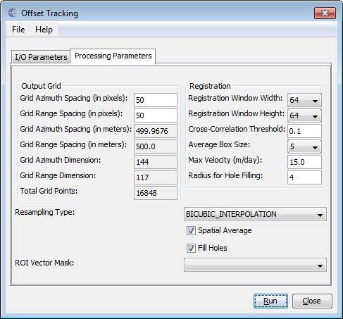
14 Radar SAR Applications Offset Tracking SAR offset tracking Adjust I/O Parameters and Processing Parameters filename: 05_ _ _orbit_Stack_subset_vel.dim set Grid Azimuth Spacing to 50 set Grid Range Spacing to 50 set Max Velocity (m/day) to 15.0 uncheck Fill Holes Optionally: File Save Parameters Press Run 14


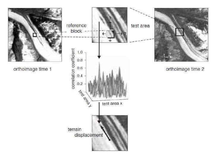
15 SAR offset tracking SAR intensity Displacement Registration Window Width / Height Grid Spacing

16 Velocity Unfold 05_ _ _orbit_Stack_subset_vel Unfold Bands Double-click on Velocity_slv1_05Nov2015 to open 16


17 Velocity direction Layer Layer Manager Deselect Vector data Click on the button to open the Add Layer window Select Coregistered GCP Movement Vector Press Finish Play around with Colour Manipulation using Sliders 17
18 Outline Data access - scihub.copernicus.eu/dhus - Batch download Software ESA Sentinel-1 Toolbox in SNAP Offset tracking - Open the products in S1TBX - View the products and metadata - Apply orbit file - Co-register the images into a stack using DEM - Create subset image containing Rink Glacier - SAR offset tracking: generate glacier velocity map - View the glacier velocity map in S1TBX - Geocoding - View the glacier velocity map in QGIS - Compare map to Sentinel-2 velocity map 18


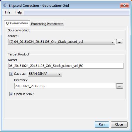

19 Geocoding Velocity Radar Geometric Ellipsoid correction Geolocation Grid Adjust I/O Parameters set filename: 06_ _ _Orb_Stack_subset_vel_EC Adjust Processing Parameters choose Map Projection UTM /WGS 84 (Automatic) Press OK and Run 19

20 Export to GeoTIFF Unfold 06_ _ _Orb_Stack_subset_vel_EC Unfold Bands Click on Velocity_slv1_05Nov2015 to select File Export GeoTIFF Filename: 07_ _ _Orb_Stack_subset_vel_EC_Geo.tif 20
21 Outline Data access - scihub.copernicus.eu/dhus - Batch download Software ESA Sentinel-1 Toolbox in SNAP Offset tracking - Open the products in S1TBX - View the products and metadata - Apply orbit file - Co-register the images into a stack using DEM - Create subset image containing Rink Glacier - SAR offset tracking: generate glacier velocity map - View the glacier velocity map in S1TBX - Geocoding - View the glacier velocity map in QGIS - Compare map to Sentinel-2 velocity map 21
")

22 QGIS Open QGIS Project New Navigate to folder and open the following files (or drag and drop) 07_ _ _Orb_Stack_subset_vel_EC_Geo.tif 02_ _intensity.tif 02_ _intensity.tif 22

23 QGIS - Layer Properties Double-click the velocity file to open Layer Properties Change settings: Render Type: Singleband pseudocolor Min: 0 Max: 9 Interpolation: Linear Color: Spectral Check Invert Mode: Equal interval Classes: 19 23


24 QGIS Profile Tool Comparison to optical offset tracking Plugins Manage and Install Plugins Search: Profile tool Select Profile Tool and press Install plugin 24

25 QGIS Profile Tool Draw line Add Layer How does the intensity look like? 25


26 Thank you!
Generate Glacier Velocity Maps with the Sentinel-1 Toolbox
 Making remote-sensing data accessible since 1991 Generate Glacier Velocity Maps with the Sentinel-1 Toolbox Adapted from the European Space Agency s STEP community platform In this document you will find:
Sentinel-1 Toolbox. Offset Tracking Tutorial Issued August Jun Lu Luis Veci
 Sentinel-1 Toolbox Offset Tracking Tutorial Issued August 2016 Jun Lu Luis Veci Copyright 2016 Array Systems Computing Inc. http://www.array.ca/ http://step.esa.int Offset Tracking Tutorial The goal of
Ice surface velocities using SAR
 Ice surface velocities using SAR Thomas Schellenberger, PhD ESA Cryosphere Remote Sensing Training Course 2018 UNIS Longyearbyen, Svalbard 12 th June 2018 thomas.schellenberger@geo.uio.no Outline Synthetic
CROP MAPPING WITH SENTINEL-2 JULY 2017, SPAIN
 _p TRAINING KIT LAND01 CROP MAPPING WITH SENTINEL-2 JULY 2017, SPAIN Table of Contents 1 Introduction to RUS... 3 2 Crop mapping background... 3 3 Training... 3 3.1 Data used... 3 3.2 Software in RUS environment...
Sentinel-1 Toolbox. Interferometry Tutorial Issued March 2015 Updated August Luis Veci
 Sentinel-1 Toolbox Interferometry Tutorial Issued March 2015 Updated August 2016 Luis Veci Copyright 2015 Array Systems Computing Inc. http://www.array.ca/ http://step.esa.int Interferometry Tutorial The
Interferometry Tutorial with RADARSAT-2 Issued March 2014 Last Update November 2017
 Sentinel-1 Toolbox with RADARSAT-2 Issued March 2014 Last Update November 2017 Luis Veci Copyright 2015 Array Systems Computing Inc. http://www.array.ca/ http://step.esa.int with RADARSAT-2 The goal of
Generating a Radiometrically Terrain Corrected (RTC) Image using the Sentinel Toolbox
 Image using the Sentinel Toolbox") Making remote-sensing data accessible since 1991 Generating a Radiometrically Terrain Corrected (RTC) Image using the Sentinel Toolbox This data recipe is for users who wish to generate an RTC image from
Making remote-sensing data accessible since 1991 Generating a Radiometrically Terrain Corrected (RTC) Image using the Sentinel Toolbox This data recipe is for users who wish to generate an RTC image from
GLACIER VELOCITY WITH SENTINEL-1 USING SNAP S-1 TOOLBOX PETERMAN GLACIER, GREENLAND
 TRAINING KIT CRYO02 GLACIER VELOCITY WITH SENTINEL-1 USING SNAP S-1 TOOLBOX PETERMAN GLACIER, GREENLAND Research and User Support for Sentinel Core Products The RUS Service is funded by the European Commission,
ALOS PALSAR. Orthorectification Tutorial Issued March 2015 Updated August Luis Veci
 ALOS PALSAR Orthorectification Tutorial Issued March 2015 Updated August 2016 Luis Veci Copyright 2015 Array Systems Computing Inc. http://www.array.ca/ http://step.esa.int ALOS PALSAR Orthorectification
NEST (Next ESA SAR Toolbox) 2C release demonstration
 2C release demonstration") NEST (Next ESA SAR Toolbox) 2C release demonstration Andrea Minchella 1 July 2009 D3l1b CONTENTS - Brief introduction to the NEST project - Basic concepts 1. How accessing data: Product readers, Open Raster
NEST (Next ESA SAR Toolbox) 2C release demonstration Andrea Minchella 1 July 2009 D3l1b CONTENTS - Brief introduction to the NEST project - Basic concepts 1. How accessing data: Product readers, Open Raster
SNAP-Sentinel-1 in a Nutshell
 SNAP-Sentinel-1 in a Nutshell Dr. Andrea Minchella 1 st ESA Advanced Training Course on Remote Sensing of the Cryosphere 13 September 2016, University of Leeds, Leeds, UK What is SNAP? Credit: SNAP The
NEST 4C-1.1: an ESA toolbox for scientific exploitation of SAR data
 NEST 4C-1.1: an ESA toolbox for scientific exploitation of SAR data Andrea Minchella RSAC c/o European Space Agency ESRIN EO Science, Applications and New Technologies Department Exploitation & Services
In addition, the image registration and geocoding functionality is also available as a separate GEO package.
 GAMMA Software information: GAMMA Software supports the entire processing from SAR raw data to products such as digital elevation models, displacement maps and landuse maps. The software is grouped into
Hands on practices on products and applications.
 Hands on practices on products and applications. Karol Paradowski Senior Specialist Institute of Geodesy and Cartography Modzelewskiego 27 Street 02-679 Warsaw Poland karol.paradowski@igik.edu.pl www.igik.edu.pl
Hands on practices on products and applications.
 Hands on practices on products and applications. Karol Paradowski Senior Specialist Institute of Geodesy and Cartography Modzelewskiego 27 Street 02-679 Warsaw Poland karol.paradowski@igik.edu.pl www.igik.edu.pl
SNAP-Sentinel-1 in a Nutshell
 SNAP-Sentinel-1 in a Nutshell Dr. Andrea Minchella 21-22/01/2016 ESA SNAP-Sentinel-1 Training Course Satellite Applications Catapult - Electron Building, Harwell, Oxfordshire What is SNAP? Credit: SNAP
CHAPTER 5 DIGITAL ELEVATION MODEL AND 3D VISUALIZATION
 CHAPTER 5 DIGITAL ELEVATION MODEL AND 3D VISUALIZATION A digital elevation model (DEM) is a digital model or 3D representation of a terrain's surface. A DEM can be represented as a raster (a grid of squares,
URBAN FOOTPRINT MAPPING WITH SENTINEL-1 DATA
 URBAN FOOTPRINT MAPPING WITH SENTINEL-1 DATA Data: Sentinel-1A IW SLC 1SSV: S1A_IW_SLC 1SSV_20160102T005143_20160102T005208_009308_00D72A_849D S1A_IW_SLC 1SSV_20160126T005142_20160126T005207_009658_00E14A_49C0
Automating a Radiometric Terrain Correction Process Chain Using a Sentinel-1 Toolbox Graph
 Making remote-sensing data accessible since 1991 Automating a Radiometric Terrain Correction Process Chain Using a Sentinel-1 Toolbox Graph Source: ASF Staff In this document you will find: A. Background
URBAN CLASSIFICATION WITH SENTINEL-1 Case Study: Germany, 2018
 _p TRAINING KIT LAND06 URBAN CLASSIFICATION WITH SENTINEL-1 Case Study: Germany, 2018 Research and User Support for Sentinel Core Products The RUS Service is funded by the European Commission, managed
The 2017 InSAR package also provides support for the generation of interferograms for: PALSAR-2, TanDEM-X
 Technical Specifications InSAR The Interferometric SAR (InSAR) package can be used to generate topographic products to characterize digital surface models (DSMs) or deformation products which identify
Orthorectifying ALOS PALSAR. Quick Guide
 Orthorectifying ALOS PALSAR Quick Guide Copyright Notice This publication is a copyrighted work owned by: PCI Geomatics 50 West Wilmot Street Richmond Hill, Ontario Canada L4B 1M5 www.pcigeomatics.com
Files Used in this Tutorial
 RPC Orthorectification Tutorial In this tutorial, you will use ground control points (GCPs), an orthorectified reference image, and a digital elevation model (DEM) to orthorectify an OrbView-3 scene that
NEST: the ESA toolbox for scientific exploitation of SAR data
 NEST: the ESA toolbox for scientific exploitation of SAR data Andrea Minchella (1), L. Veci (2), Marcus Engdahl (3) and Petar Marinkovic (4) (1) RSAC c/o European Space Agency, ESA-ESRIN (2) Array Systems
SENTINEL-2 PROCESSING IN SNAP
 SENTINEL-2 PROCESSING IN SNAP EXERCISE 1 (exploring S2 data) Data: Sentinel-2A Level 1C: S2A_MSIL1C_20170316T094021_N0204_R036_T33SVB_20170316T094506.SAFE 1. Open file 1.1. File / Open Product 1.2. Browse
NEST: an ESA toolbox for scientific exploitation of SAR data
 NEST: an ESA toolbox for scientific exploitation of SAR data M.Engdahl (ESA-ESRIN), A. Minchella (RSAC c/o ESA), P. Marinkovic (Ppo.Labs), L. Veci (Array Systems Computing) 26/07/2012 IGARSS 2012 Munich
Sentinel-1 Toolbox. TOPS Interferometry Tutorial Issued May 2014
 Sentinel-1 Toolbox TOPS Interferometry Tutorial Issued May 2014 Copyright 2015 Array Systems Computing Inc. http://www.array.ca/ https://sentinel.esa.int/web/sentinel/toolboxes Interferometry Tutorial
FLOOD MONITORING WITH SENTINEL-1 USING S-1 TOOLBOX - JANUARY 2015, MALAWI
 TRAINING KIT HAZA01 FLOOD MONITORING WITH SENTINEL-1 USING S-1 TOOLBOX - JANUARY 2015, MALAWI Table of Contents 1 Introduction to RUS... 2 2 Training... 2 2.1 Data used... 2 2.2 Software in RUS environment...
OIL SPILL MAPPING WITH SENTINEL-1 AUGUST 2017, KUWAIT
 _p TRAINING KIT OCEA03 OIL SPILL MAPPING WITH SENTINEL-1 AUGUST 2017, KUWAIT Table of Contents 1 Introduction to RUS... 3 2 Oil spill mapping background... 3 3 Training... 3 3.1 Data used... 3 3.2 Software
Files Used in this Tutorial
 RPC Orthorectification Tutorial In this tutorial, you will use ground control points (GCPs), an orthorectified reference image, and a digital elevation model (DEM) to orthorectify an OrbView-3 scene that
SHIP DETECTION WITH SENTINEL-1 USING SNAP S-1 TOOLBOX - GULF OF TRIESTE, ITALY
 TRAINING KIT - OCEA01 SHIP DETECTION WITH SENTINEL-1 USING SNAP S-1 TOOLBOX - GULF OF TRIESTE, ITALY Table of Contents 1 Introduction... 3 2 Training... 3 2.1 Data used... 3 2.2 Software in RUS environment...
LAND SUBSIDENCE WITH SENTINEL-1 using SNAP
 _p TRAINING KIT HAZA03 LAND SUBSIDENCE WITH SENTINEL-1 using SNAP Table of Contents 1 Introduction... 2 2 Training... 2 2.1 Data used... 2 2.2 Software in RUS environment... 2 3 Step by step... 3 3.1 Data
Terrain correction. Backward geocoding. Terrain correction and ortho-rectification. Why geometric terrain correction? Rüdiger Gens
 Terrain correction and ortho-rectification Terrain correction Rüdiger Gens Why geometric terrain correction? Backward geocoding remove effects of side looking geometry of SAR images necessary step to allow
The Radar Ortho Suite is an add-on to Geomatica. It requires Geomatica Core or Geomatica Prime as a pre-requisite.
 RADAR ORTHO SUITE The Radar Ortho Suite includes rigorous and rational function models developed to compensate for distortions and produce orthorectified radar images. Distortions caused by the platform
SENTINEL-1 Toolbox. SAR Basics Tutorial Issued March 2015 Updated August Luis Veci
 SENTINEL-1 Toolbox SAR Basics Tutorial Issued March 2015 Updated August 2016 Luis Veci Copyright 2015 Array Systems Computing Inc. http://www.array.ca/ http://step.esa.int SAR Basics Tutorial The goal
DEFORESTATION MONITORING WITH SENTINEL-1 Case Study: Paraguay, 2018
 _p TRAINING KIT LAND07 DEFORESTATION MONITORING WITH SENTINEL-1 Case Study: Paraguay, 2018 Research and User Support for Sentinel Core Products The RUS Service is funded by the European Commission, managed
Individual Interferograms to Stacks
 Individual Interferograms to Stacks Piyush Agram Jet Propulsion Laboratory Aug 1, 2016 @UNAVCO Thanks to my colleagues from JPL, Caltech, Stanford University and from all over the world for providing images
Differential Interferometry and Geocoding Software DIFF&GEO
 Documentation User s Guide Differential Interferometry and Geocoding Software DIFF&GEO Geocoding and Image Registration Version 1.6 May 2011 GAMMA Remote Sensing AG, Worbstrasse 225, CH-3073 Gümligen,
GAMMA Software. Introduction:
 v1.1, 1-Dec-2017 page 1 GAMMA Software Introduction: GAMMA Software supports the entire processing chain from SAR raw data to products such as digital elevation models, displacement maps and landuse maps.
InSAR DEM; why it is better?
 InSAR DEM; why it is better? What is a DEM? Digital Elevation Model (DEM) refers to the process of demonstrating terrain elevation characteristics in 3-D space, but very often it specifically means the
Files Used in this Tutorial
 Generate Point Clouds and DSM Tutorial This tutorial shows how to generate point clouds and a digital surface model (DSM) from IKONOS satellite stereo imagery. You will view the resulting point clouds
GY301 Geomorphology Lab 5 Topographic Map: Final GIS Map Construction
 GY301 Geomorphology Lab 5 Topographic Map: Final GIS Map Construction Introduction This document describes how to take the data collected with the total station for the campus topographic map project and
Sentinel-1 InSAR AP workshop
 Sentinel-1 InSAR AP workshop Sentinel-1 InSAR progress and experience at GAMMA U. Wegmüller, C. Werner, A. Wiesmann, T. Strozzi Gamma Remote Sensing AG - Progress made since S1A Expert Users meeting at
Interferometric SAR Processor - ISP
 Documentation User s Guide Interferometric SAR Processor - ISP Version 1.4 November 2009 GAMMA Remote Sensing AG, Worbstrasse 225, CH-3073 Gümligen, Switzerland tel: +41-31-951 70 05, fax: +41-31-951 70
SHIP DETECTION IN SENTINEL-1 OCTOBER 2016, GULF OF TRIESTE
 TRAINING KIT SHIP DETECTION IN SENTINEL-1 OCTOBER 2016, GULF OF TRIESTE Table of Contents 1 Introduction... 2 2 Barcolana Regatta - Gulf Of Trieste, 9 October 2016... 2 3 Training... 3 3.1 Data used...
Individual Interferograms to Stacks!
 Individual Interferograms to Stacks! Piyush Agram! Jet Propulsion Laboratory!! Jun 29, 2015! @UNAVCO! Thanks to my colleagues from JPL, Caltech, Stanford University and from all over the world for providing
Technical Specifications
 1 Contents INTRODUCTION...3 ABOUT THIS LAB...3 IMPORTANCE OF THIS MODULE...3 EXPORTING AND IMPORTING DATA...4 VIEWING PROJECTION INFORMATION...5...6 Assigning Projection...6 Reprojecting Data...7 CLIPPING/SUBSETTING...7
Sentinel-1 processing with GAMMA software
 Documentation User s Guide Sentinel-1 processing with GAMMA software Including an example of Sentinel-1 SLC co-registration and differential interferometry Version 1.1 May 2015 GAMMA Remote Sensing AG,
GMES TERRAFIRMA. Validation of existing processing chains in Terrafirma stage 2 LIST OF OSP DELIVERABLES EXTENDED
 GMES TERRAFIRMA ESRIN/Contract no. 19366/05/I-E Validation of existing processing chains in Terrafirma stage 2 LIST OF OSP DELIVERABLES EXTENDED 5 th July 2007 Final version - ERS M. Crosetto, M. Agudo
Combination of GNSS and InSAR for Future Australian Datums
 Combination of GNSS and InSAR for Future Australian Datums Thomas Fuhrmann, Matt Garthwaite, Sarah Lawrie, Nick Brown Interferometric Synthetic Aperture Radar Motivation Current situation Static Datum:
All data is in Universal Transverse Mercator (UTM) Zone 6 projection, and WGS 84 datum.
 Zone 6 projection, and WGS 84 datum.") 111 Mulford Hall, College of Natural Resources, UC Berkeley (510) 643-4539 EXPLORING MOOREA DATA WITH QUANTUM GIS In this exercise, you will be using an open-source FREE GIS software, called Quantum GIS,
111 Mulford Hall, College of Natural Resources, UC Berkeley (510) 643-4539 EXPLORING MOOREA DATA WITH QUANTUM GIS In this exercise, you will be using an open-source FREE GIS software, called Quantum GIS,
Mapping Regional Inundation with Spaceborne L-band SAR
 Making remote-sensing data accessible since 1991 Mapping Regional Inundation with Spaceborne L-band SAR Using open-source software such as QGIS and GIMP Adapted from Bruce Chapman 1, Rick Guritz 2, and
ENVI 5 & E3De. The Next Generation of Image Analysis
 ENVI 5 & E3De The Next Generation of Image Analysis The information contained in this document pertains to software products and services that are subject to the controls of the Export Administration Regulations
Interferometric processing. Rüdiger Gens
 Rüdiger Gens Why InSAR processing? extracting three-dimensional information out of a radar image pair covering the same area digital elevation model change detection 2 Processing chain 3 Processing chain
v STWAVE Analysis SMS 11.2 Tutorial Requirements Map Module STWAVE Cartesian Grid Module Scatter Module Prerequisites Time minutes
 v. 11.2 SMS 11.2 Tutorial Objectives This workshop gives a brief introduction to the STWAVE modules. Data from the Shinnecock Inlet, Long Island, New York, have been set up as an example. This example
Exercise 3-1: Soil property mapping
 Exercise 3-1: Soil property mapping Mapping objectives: Create a soil analysis point layer from tabular data in QGIS Create a continuous surface soil property map using Kriging Interpolation in SAGA GIS
Terrain Analysis. Using QGIS and SAGA
 Terrain Analysis Using QGIS and SAGA Tutorial ID: IGET_RS_010 This tutorial has been developed by BVIEER as part of the IGET web portal intended to provide easy access to geospatial education. This tutorial
INSAR DEMS; ACHIEVEMENTS AND BENEFITS
 INSAR DEMS; ACHIEVEMENTS AND BENEFITS Parviz TARIKHI, Iran Key words: remote sensing, InSAR, DEM, deformation measurement, Iran SUMMARY InSAR is a radar technique for combining synthetic aperture radar
Interferometric SAR Processing
 Documentation - Theory Interferometric SAR Processing Version 1.0 November 2007 GAMMA Remote Sensing AG, Worbstrasse 225, CH-3073 Gümligen, Switzerland tel: +41-31-951 70 05, fax: +41-31-951 70 08, email:
Stereo DEM Extraction from Radar Imagery Geomatica 2015 Tutorial
 Stereo DEM Extraction from Radar Imagery Geomatica 2015 Tutorial The purpose of this tutorial is to provide the steps necessary to extract a stereo DEM model from Radar imagery. This method of DEM extraction
MULTI-TEMPORAL SAR DATA FILTERING FOR LAND APPLICATIONS. I i is the estimate of the local mean backscattering
 MULTI-TEMPORAL SAR DATA FILTERING FOR LAND APPLICATIONS Urs Wegmüller (1), Maurizio Santoro (1), and Charles Werner (1) (1) Gamma Remote Sensing AG, Worbstrasse 225, CH-3073 Gümligen, Switzerland http://www.gamma-rs.ch,
TerrainOnDemand ArcGIS
 TM TerrainOnDemand ArcGIS Connect to Intermap Technologies NEXTMap data within: ArcGIS Desktop 9.3.1 and Above AGDQS0312 TerrainOnDemand ArcGIS 2 TerrainOnDemand ArcGIS Table of Contents 1. Introduction...1
Data Warehouse Phase 2 CORE Datasets Status 15 th December 2018
 Data Warehouse Phase 2 CORE Datasets Status 15 th December 2018 The document presents the status of the open CORE datasets, for which data provision is on-going. Once closed, content of the datasets can
Getting started with SARscape for Windows
 Getting started with SARscape for Windows Version 1.1 April 2017 1 Index Introduction... 3 SARscape Quick Start... 4 Install SARscape... 4 Install SARscape Patch... 5 Uninstall SARscape... 6 ENVI environment
Search, Order and Customize NASA SMAP Data with NASA Earthdata Search
 Search, Order and Customize NASA SMAP Data with NASA Earthdata Search In this step-by-step tutorial, we will demonstrate how to search, order, and customize NASA Soil Moisture Active Passive, or SMAP data
PolSARpro v4.03 Forest Applications
 PolSARpro v4.03 Forest Applications Laurent Ferro-Famil Lecture on polarimetric SAR Theory and applications to agriculture & vegetation Thursday 19 April, morning Pol-InSAR Tutorial Forest Application
Sema Foundation ICT Department. Lesson - 18
 Lesson - 18 1 Manipulating Windows We can work with several programs at a time in Windows. To make working with several programs at once very easy, we can change the size of the windows by: maximize minimize
SAR Interferometry. Dr. Rudi Gens. Alaska SAR Facility
 SAR Interferometry Dr. Rudi Gens Alaska SAR Facility 2 Outline! Relevant terms! Geometry! What does InSAR do?! Why does InSAR work?! Processing chain " Data sets " Coregistration " Interferogram generation
SENTINEL-1 SUPPORT IN THE GAMMA SOFTWARE
 SENTINEL-1 SUPPORT IN THE GAMMA SOFTWARE Urs Wegmüller, Charles Werner, Tazio Strozzi, Andreas Wiesmann, Othmar Frey, and Maurizio Santoro Gamma Remote Sensing, Worbstrasse 225, 3073 Gümligen BE, Switzerland
Introduction. Contour Lines Generation
 Introduction Over the years the e-foto project has been developed and the need for integration with other Geographic Information Systems software became more evident. From this need several improvements
Stereo DEM Extraction from Radar Imagery Geomatica 2014 Tutorial
 The purpose of this tutorial is to provide the steps necessary to extract a stereo DEM model from Radar imagery. This method of DEM extraction is useful if you do not have high resolution optical imagery
SARscape. Table of Contents. Preface 1. Overview 3. Basic Module 5. Focusing Module 11. Gamma and Gaussian Filtering Module 11
 Table of Contents Preface 1 Overview 3 Basic Module 5 Focusing Module 11 Gamma and Gaussian Filtering Module 11 Interferometry Module 13 ScanSAR Interferometry Module 18 Polarimetry and Polarimetric Interferometry
SentiNel Application Platform as InSAR processor for PSI processing with StaMPS
 SentiNel Application Platform as InSAR processor for PSI processing with StaMPS Authors: José Manuel Delgado Blasco Michael Foumelis Date: June 2018 1 Contents 1 Introduction... 3 1.1 Installation... 3
button in the lower-left corner of the panel if you have further questions throughout this tutorial.
 Mosaic Tutorial: Simple Workflow This tutorial demonstrates how to use the Seamless Mosaic tool to mosaic six overlapping digital aerial scenes. You will learn about displaying footprints and image data
Norwegian Polar Institute, February 2018 Project website: quantarctica.npolar.no
 Get started with Quantarctica 3 Norwegian Polar Institute, February 2018 Project website: quantarctica.npolar.no Quantarctica is the result of an initiative by the Norwegian Polar Institute (NPI) to develop
Download elevation model page 2 Re-Project DEM coordinates page 5 Cut region of interest page 10
 1 Download elevation model page 2 Re-Project DEM coordinates page 5 Cut region of interest page 10 Version June 2017, Dr. Jonas von Rütte, Dr. Peter Lehmann 2 Download elevation model for region of interest:
Feedbacks on some present DINSAR 1 processing suites:
 Feedbacks on some present DINSAR 1 processing suites: An overview on interferometric SAR 2 software and a comparison between DORIS and SARSCAPE packages Elisabeth Simonetto, Jean-Michel Follin L2G (Laboratoire
Visual Analytics User s Guide
 Visual Analytics User s Guide Question Page How do I log on to the system? 2 How do I navigate the reports? 3 How do I view an object that does not fit on the screen? 3 How do I change the column width
Radar Data Processing, Quality Analysis and Level-1b Product Generation for AGRISAR and EAGLE campaigns
 Radar Data Processing, Quality Analysis and Level-1b Product Generation for AGRISAR and EAGLE campaigns German Aerospace Center (DLR) R. Scheiber, M. Keller, J. Fischer, R. Horn, I. Hajnsek Outline E-SAR
AUTOMATIC INTERPRETATION OF HIGH RESOLUTION SAR IMAGES: FIRST RESULTS OF SAR IMAGE SIMULATION FOR SINGLE BUILDINGS
 AUTOMATIC INTERPRETATION OF HIGH RESOLUTION SAR IMAGES: FIRST RESULTS OF SAR IMAGE SIMULATION FOR SINGLE BUILDINGS J. Tao *, G. Palubinskas, P. Reinartz German Aerospace Center DLR, 82234 Oberpfaffenhofen,
TECHNICAL ASPECTS OF ENVISAT ASAR GEOCODING CAPABILITY AT DLR
 TECHNICAL ASPECTS OF ENVISAT ASAR GEOCODING CAPABILITY AT DLR Martin Huber¹, Wolfgang Hummelbrunner², Johannes Raggam², David Small³, Detlev Kosmann¹ ¹ DLR, German Remote Sensing Data Center, Oberpfaffenhofen,
Flood detection using radar data Basic principles
 Flood detection using radar data Basic principles André Twele, Sandro Martinis and Jan-Peter Mund German Remote Sensing Data Center (DFD) 1 Overview Introduction Basic principles of flood detection using
Automatic DEM Extraction
 Technical Specifications Automatic DEM Extraction The Automatic DEM Extraction module allows you to create Digital Elevation Models (DEMs) from stereo airphotos, stereo images and RADAR data. Image correlation
Eric Pottier, Laurent Ferro-Famil, Sophie Allain, Stéphane Méric. Irena Hajnsek, Kostas Papathanassiou, Alberto Moreira,
 PolSARpro v4.0 Software and ALOS-PALSAR Pol-SAR Data Processing Eric Pottier, Laurent Ferro-Famil, Sophie Allain, Stéphane Méric Shane Cloude, Irena Hajnsek, Kostas Papathanassiou, Alberto Moreira, Mark
Onshore remote sensing applications: an overview
 Onshore remote sensing applications: an overview Dr. Richard Teeuw and Dr. Malcolm Whitworth School of Earth and Environmental Sciences, University of Portsmouth, UK. Overview Presentation on the applications
Practical work on SAR Interferometry Data Processing using DORIS Software Y.S. Rao CSRE, IIT Bombay
 Practical work on SAR Interferometry Data Processing using DORIS Software Y.S. Rao CSRE, IIT Bombay ysrao@csre.iitb.ac.in Tools : DORIS (Delft Object-Oriented Radar Interferometric Software) is freely
Download the Latest LTR QGIS version (2.18) from the QGIS website: download.qgis.org/ >> Settings > Options > Locale
 from the QGIS website: download.qgis.org/ >> Settings > Options > Locale") Exercise 1: Introduction to QGIS Aim: To understand the basis of GIS To learn the basics of a GIS software (QGIS) INTRODUCTION Software Access Download the Latest LTR QGIS version (2.18) from the QGIS
Exercise 1: Introduction to QGIS Aim: To understand the basis of GIS To learn the basics of a GIS software (QGIS) INTRODUCTION Software Access Download the Latest LTR QGIS version (2.18) from the QGIS
Working with demographic grids in QGIS
 Working with demographic grids in QGIS Anna Dmowska dmowska@amu.edu.pl April 2017 1. Introduction SocScape (Social Landscape) is a research project which provides open access to high resolution (30 m)
ENVI Tutorial: Basic SAR Processing and Analysis
 ENVI Tutorial: Basic SAR Processing and Analysis Table of Contents OVERVIEW OF THIS TUTORIAL...2 Background...2 SINGLE-BAND SAR PROCESSING...3 Read and Display RADARSAT CEOS Data...3 Review CEOS Header...3
Release Notes GAMMA Software,
 Release Notes GAMMA Software, 20170630 Urs Wegmüller, Charles Werner, Andreas Wiesmann, Othmar Frey, Christophe Magnard, Oliver Cartus Gamma Remote Sensing AG Worbstrasse 225, CH-3073 Gümligen http://www.gamma-rs.ch
Tutorial 1 - Run WOIS Workflow Using Data Selected on the HEP Webportal
 WOIS Quick Start Guide This document contains a set of tutorials explaining how to start using WOIS software on HEP (Hydrology Exploitation Platform). The tutorials are sequences of steps taken from user
Scene Matching on Imagery
 Scene Matching on Imagery There are a plethora of algorithms in existence for automatic scene matching, each with particular strengths and weaknesses SAR scenic matching for interferometry applications
Introduction to GIS 2011
 Introduction to GIS 2011 Digital Elevation Models CREATING A TIN SURFACE FROM CONTOUR LINES 1. Start ArcCatalog from either Desktop or Start Menu. 2. In ArcCatalog, create a new folder dem under your c:\introgis_2011
ESRI stylesheet selects a subset of the entire body of the metadata and presents it as if it was in a tabbed dialog.
 Creating Metadata using ArcCatalog (ACT) 1. Choosing a metadata editor in ArcCatalog ArcCatalog comes with FGDC metadata editor, which create FGDC-compliant documentation. Metadata in ArcCatalog stored
Coordinate Systems/Units
 GIS and Mapping Procedures in fgis Beginning a fgis Project Adding Basemap Data Adding GPS Data Editing Layer Properties Checking Feature Attributes Adding Acres to Area Features Adding Acres Labels to
ANALYSIS OF THE GEOMETRIC ACCURACY PROVIDED BY THE FORWARD GEOCODING OF SAR IMAGES
 ANALYSIS OF THE GEOMETRIC ACCURACY PROVIDED BY THE FORWARD GEOCODING OF SAR IMAGES V. Karathanassi, Ch. Iossifidis, and D. Rokos Laboratory of Remote Sensing, Department of Rural and Surveying Engineering,
Advanced GIS Using GRASS to create SVF and LRM
 Advanced GIS Using GRASS to create SVF and LRM Table of Contents Aims...2 Outcomes...2 How to use this booklet...2 Task 1 Creating a GRASS location from QGIS...3 Task 2 Changing the GRASS Region...8 Task
Target Lithology Voxels
 Target Lithology Voxels The Target Lithology Voxels tool enables you to create a 3D grid (voxel) based on data contained in a string channel within a from-to drillhole database. A lithology voxel can be
Copyright GeoSLAM Viewer User Guide 2017 GeoSLAM Ltd. All rights reserved. Version GeoSLAM Ltd 1 GeoSLAM Viewer User Guide v1.0.
 Copyright GeoSLAM Viewer User Guide 2017 GeoSLAM Ltd. All rights reserved. Version 1.0.0 2017 GeoSLAM Ltd 1 GeoSLAM Viewer User Guide v1.0.0 2017 GeoSLAM Ltd 2 GeoSLAM Viewer User Guide v1.0.0 CONTENTS
Zeiss Efficient Navigation (ZEN) Blue Edition Standard Operation Protocol
 Blue Edition Standard Operation Protocol") Faculty Core Facility ZEN BLUE 2.3 SOP A-1 Zeiss Efficient Navigation (ZEN) Blue Edition Standard Operation Protocol Faculty Core Facility ZEN BLUE 2.3 SOP A-2 A. Content Overview. 3 Start up. 4 Display
Faculty Core Facility ZEN BLUE 2.3 SOP A-1 Zeiss Efficient Navigation (ZEN) Blue Edition Standard Operation Protocol Faculty Core Facility ZEN BLUE 2.3 SOP A-2 A. Content Overview. 3 Start up. 4 Display