Hands-on Session: Calibrate the CREST Model
|
|
|
- Berniece Collins
- 5 years ago
- Views:
Transcription


1 Hands-on Session: Calibrate the CREST Model Xianwu Xue April 3 rd 2012
2 Background Hydrologic models often contain parameters that cannot be measured directly but which can only be inferred by a trialand-error (calibration) process that adjusts the parameter values to closely match the input-output behavior of the model to the real system it represents. Traditional calibration procedures, which involve manual adjustment of the parameter values, are labor-intensive, and their success is strongly dependent on the experience of the modeler. Automatic methods for model calibration, which seek to take advantage of the speed and power of computers while being objective and relatively easy to implement Vrugt, J. A., H. V. Gupta, W. Bouten, et al. (2003), A Shuffled Complex Evolution Metropolis algorithm for optimization and uncertainty assessment of hydrologic model parameters, Water Resources Research, 39.
3 Question!!! Did you calibrate a model? How complex the model? (Number Parameters/Variables ) Manually or Automatically?
4 Table of Contents You need streamflow observations for the model calibration. Manual Calibration Automatic Calibration SCE-UA (Shuffled Complex Evolution The University of Arizona)

5 OBS Folder Wangchu_Obs.csv (Using.csv format by Excel) Station Name + _Obs.csv Date Column depends on the run options for example: Year + Month + Day + Hour + Minute + Second Runoff Column: m 3 /s

6 Try the Example Basin using Manual Calibration Let s modify one of the parameter value to see how the results change, use the table here as the range of the parameters: The NSCE increased or decreased? Try others Do you got a good results? How long do you use?

7 How do you feel? Tired? Exhausted? Despaired? Do you want to calibrate the model manually? Automatic Calibration!!!
8 SCE-UA shuffled complex evolution (SCE) method Duan, Q. Y., V. K. Gupta, and S. Sorooshian (1993), Shuffled complex evolution approach for effective and efficient global minimization, Journal Of Optimization Theory And Applications, 76(3),
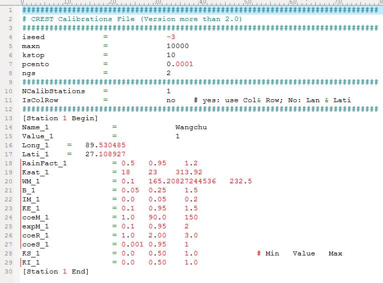
9 Calibrations.txt
10 Calibration Parameters iseed = initial random seed maxn = maximum number of trials allowed before optimization is terminated kstop = number of shuffling loops in which the criterion value must change by "pecnto" before optimization is terminated pecnto = percentage by which the criterion value must change in "kstop" shuffling loops ngs = number of complexes in a sample population
11 Parameters Symbol Ksat RainFact WM B IM KE coem expm coer coes KS KI Description the Soil saturate hydraulic conductivity the multiplier on the precipitation field The Mean Water Capacity the exponent of the variable infiltration curve Impervious area ratio The factor to convert the PET to local actual overland runoff velocity coefficient overland flow speed exponent multiplier used to convert overland flow speed to channel flow speed multiplier used to convert overland flow speed to interflow flow speed Overland reservoir Discharge Parameter Interflow Reservoir Discharge Parameter
12 Evaluation indices Nash-Sutcliffe Coefficient of Efficiency Relative Bias (%) was used to assess the systematic bias of runoff The correlation coefficient (CC) is used to assess the agreement NSCE = 1 n n Rsim, i Robs, i i= 1 i= 1 Bias = 100 n R obs, i i= 1 CC = between simulated runoff and observed runoff n n i= 1 n ( Robs, i Rsim, i ) i= 1 n i= 1 ( R ) obs, i Robs ( Robs, i Robs )( Rsim, i Rsim ) n ( Robs, i Robs ) ( Rsim, i Rsim ) i= 1 i=
13 Validation of the Results Calibration (2001) Validation (2002) NSCE Bias(%) CC Runoff (m 3 /s) Calibration Validation R RObs
14 Calibration Period: Validation Period:
15 Let s try the automatic calibration!


16 First Step: Modify the Parameter File Modify the KS value to 1.0 in Parameters.txt and then save the file

17 Second Step: Modify the Calibration File Comments all the parameters in Calibrations.txt except KS and then save the file


18 Third Step: Modify the Project File Select cali_sceua in Wangchu_CREST_V6_Daily.Project file and then save the file

19 Final Step: Calibrate the model
20 Take Exercises Try the manual calibration and automatic calibration using the example basin If you have other questions, please feel free to ask me
21 Thank you for your attention!
Automatic Calibration. University of Oklahoma/HyDROS Module 2.4
 Automatic Calibration University of Oklahoma/HyDROS Module 2.4 Outline Day 2 EF5 OVERVIEW DEM DERIVATIVES RAINFALL AND PET AUTOMATIC CALIBRATION Description of EF5/CREST parameters Description of EF5/KW
EF5 Overview. University of Oklahoma/HyDROS Module 1.3
 EF5 Overview University of Oklahoma/HyDROS Module 1.3 Outline Day 1 WELCOME INTRODUCTION TO HYDROLOGICAL MODELS EF5 OVERVIEW Features of EF5 Model structure Control file options Warm-up and model states
NASA-OU CREST 1.6c README
 NASA-OU CREST 1.6c README 27 May 2010 (Draft version) Table of Contents 1. A BRIEF DESCRIPTION OF THE MODEL 3 2. COMPILING ON LINUX 5 2.1 USING IFORT COMPILER 5 2.2 USING GFORTRAN COMPILER 5 3. COMPILING
Identifying and reducing model structure uncertainty based on analysis of parameter interaction
 Adv. Geosci., 11, 117 122, 2007 Author(s) 2007. This work is licensed under a Creative Commons License. Advances in Geosciences Identifying and reducing model structure uncertainty based on analysis of
Comparison of parameter estimation algorithms in hydrological modelling
 Calibration and Reliability in Groundwater Modelling: From Uncertainty to Decision Making (Proceedings of ModelCARE 2005, The Hague, The Netherlands, June 2005). IAHS Publ. 304, 2006. 67 Comparison of
Automated calibration applied to a GIS-based flood simulation model using PEST
 Floods, from Defence to Management Van Alphen, van Beek & Taal (eds) 2005 Taylor & Francis Group, London, ISBN 0 415 38050 2 Automated calibration applied to a GIS-based flood simulation model using PEST
Particle Swarm Optimization for Calibrating and Optimizing Xinanjiang Model Parameters
 Particle Swarm Optimization for Calibrating and Optimizing Xinanjiang Model Parameters Kuok King Kuok Lecturer, School of Engineering, Computing and Science, Swinburne University of Technology Sarawak
Comparison of multiple point and single point calibration performance for the Saginaw River Watershed
 Comparison of multiple point and single point calibration performance for the Saginaw River Watershed Fariborz Daneshvar, A 1. Pouyan Nejadhashemi 1, Matthew R. Herman 1 1 Department of Biosystems and
SWAT-CUP Calibration and Uncertainty Programs for SWAT
 SWAT-CUP Calibration and Uncertainty Programs for SWAT K.C. Abbaspour 1, M. Vejdani, S. Haghighat 1 Eawag: Swiss Federal Institute of Aquatic Science and Technology, Ueberlandstr 133, P.O. Box 611, 86
Global optimisation techniques in water resources management
 XXVI General Assembly of European Geophysical Society Nice, France, 6-30 March 001 HSC/ Water Resources Engineering: Hydroinformatics Global optimisation techniques in water resources management Andreas
Automatic calibration of the MIKE SHE integrated hydrological modelling system
 Automatic calibration of the MIKE SHE integrated hydrological modelling system Henrik Madsen and Torsten Jacobsen DHI Water & Environment Abstract In this paper, automatic calibration of an integrated
A new multiscale routing framework and its evaluation for land surface modeling applications
 WATER RESOURCES RESEARCH, VOL. 48,, doi:10.1029/2011wr011337, 2012 A new multiscale routing framework and its evaluation for land surface modeling applications Zhiqun Wen, 1,2,4 Xu Liang, 2,3 and Shengtian
On Automatic Calibration of the SWMM Model
 On Automatic Calibration of the SWMM Model Van-Thanh-Van Nguyen, Hamed Javaheri and Shie-Yui Liong Conceptual urban runoff (CUR) models, such as the U.S. Environmental Protection Agency Storm Water Management
Spatial Hydrologic Modeling HEC-HMS Distributed Parameter Modeling with the MODClark Transform
 v. 9.0 WMS 9.0 Tutorial Spatial Hydrologic Modeling HEC-HMS Distributed Parameter Modeling with the MODClark Transform Setup a basic distributed MODClark model using the WMS interface Objectives In this
Hydrologic Modeling using HEC-HMS
 Hydrologic Modeling using HEC-HMS CE 412/512 Spring 2017 Introduction The intent of this exercise is to introduce you to the structure and some of the functions of the HEC-Hydrologic Modeling System (HEC-HMS),
Overview of Model Calibration General Strategy & Optimization
 Overview of Model Calibration General Strategy & Optimization Logan Karsten National Center for Atmospheric Research General Strategy Simple enough. Right?... 2 General Strategy Traditional NWS lumped
A Framework for Incorporating Uncertainty Sources in SWAT Modeling
 A Framework for Incorporating Uncertainty Sources in SWAT Modeling Haw Yen X. Wang, D. G. Fontane, R. D. Harmel, M. Arabi July 30, 2014 2014 International SWAT Conference Pernambuco, Brazil Outline Overview
Automated Calibration of the GSSHA Watershed Model: A Look at Accuracy and Viability for Routine Hydrologic Modeling
 Brigham Young University BYU ScholarsArchive All Theses and Dissertations 2009-11-23 Automated Calibration of the GSSHA Watershed Model: A Look at Accuracy and Viability for Routine Hydrologic Modeling
How effective and efficient are multiobjective evolutionary algorithms at hydrologic model calibration?
 How effective and efficient are multiobjective evolutionary algorithms at hydrologic model calibration? Y. Tang, P. Reed, T. Wagener To cite this version: Y. Tang, P. Reed, T. Wagener. How effective and
Assignment Two Part Two: Calibration for Flow Due April 3
 Assignment Two Part Two: Calibration for Flow Due April 3 The objective of part 2 of this project is to calibrate the tutorial SWAT model developed in part 1 for flow. Re-Running Part 1 The precipitation
v Prerequisite Tutorials GSSHA Modeling Basics Stream Flow GSSHA WMS Basics Creating Feature Objects and Mapping their Attributes to the 2D Grid
 v. 10.1 WMS 10.1 Tutorial GSSHA Modeling Basics Developing a GSSHA Model Using the Hydrologic Modeling Wizard in WMS Learn how to setup a basic GSSHA model using the hydrologic modeling wizard Objectives
Toward improved identifiability of hydrologic model parameters: The information content of experimental data
 WATER RESOURCES RESEARCH, VOL. 38, NO. 12, 1312, doi:10.1029/2001wr001118, 2002 Toward improved identifiability of hydrologic model parameters: The information content of experimental data Jasper A. Vrugt
Use of evaporation and streamflow data in hydrological model calibration
 Use of evaporation and streamflow data in hydrological model calibration Jeewanthi Sirisena* Assoc./Prof. S. Maskey Prof. R. Ranasinghe IHE-Delft Institute for Water Education, The Netherlands Background
WMS 10.0 Tutorial Storm Drain Modeling SWMM Modeling Learn how to link a hydrologic model to the SWMM storm drain model
 v. 10.0 WMS 10.0 Tutorial Learn how to link a hydrologic model to the SWMM storm drain model Objectives Build a rational method hydrologic model and compute sub-basin flows. Import storm drain network
WMS 9.1 Tutorial Storm Drain Modeling SWMM Modeling Learn how to link a hydrologic model to the SWMM storm drain model
 v. 9.1 WMS 9.1 Tutorial Learn how to link a hydrologic model to the SWMM storm drain model Objectives Build a rational method hydrologic model and compute sub-basin flows. Import storm drain network information
Comparison of Three Multiobjective Optimization Algorithms for Inverse Modeling of Vadose Zone Hydraulic Properties
 Comparison of Three Multiobjective Optimization Algorithms for Inverse Modeling of Vadose Zone Hydraulic Properties Thomas Wöhling* Lincoln Environmental Research Lincoln Ventures Ltd. Ruakura Research
Learn how to link a hydrologic model to the SWMM storm drain model
 v. 10.1 WMS 10.1 Tutorial Learn how to link a hydrologic model to the SWMM storm drain model Objectives Build a rational method hydrologic model and compute sub-basin flows. Import storm drain network
Shuffled Complex Evolution Model Calibrating Algorithm: Enhancing its Robustness and Efficiency
 This is a Pre-Published Version. Shuffled Complex Evolution Model Calibrating Algorithm: Enhancing its Robustness and Efficiency Nitin Muttil 1 and A. W. Jayawardena 2 1 School of Architectural, Civil
Estimation of Design Flow in Ungauged Basins by Regionalization
 Estimation of Design Flow in Ungauged Basins by Regionalization Yu, P.-S., H.-P. Tsai, S.-T. Chen and Y.-C. Wang Department of Hydraulic and Ocean Engineering, National Cheng Kung University, Taiwan E-mail:
Module 9. Lecture 3: Major hydrologic models-hspf, HEC and MIKE
 Lecture 3: Major hydrologic models-hspf, HEC and MIKE Major Hydrologic Models HSPF (SWM) HEC MIKE Hydrological Simulation Program-Fortran (HSPF) Commercial successor of the Stanford Watershed Model (SWM-IV)
Watershed Modeling HEC-HMS Interface
 v. 10.1 WMS 10.1 Tutorial Learn how to set up a basic HEC-HMS model using WMS Objectives Build a basic HEC-HMS model from scratch using a DEM, land use, and soil data. Compute the geometric and hydrologic
MODFLOW UZF Package The MODFLOW Unsaturated-Zone Flow (UZF) Package Interface in GMS
 Package Interface in GMS") v. 10.2 GMS 10.2 Tutorial The MODFLOW Unsaturated-Zone Flow (UZF) Package Interface in GMS Objectives This tutorial explains how to use the MODFLOW Unsaturated-Zone Flow (UZF) package and compares it to
v. 10.2 GMS 10.2 Tutorial The MODFLOW Unsaturated-Zone Flow (UZF) Package Interface in GMS Objectives This tutorial explains how to use the MODFLOW Unsaturated-Zone Flow (UZF) package and compares it to
Watershed Modeling National Streamflow Statistics Program (NSS) Interface
 Interface") v. 9.1 WMS 9.1 Tutorial Watershed Modeling National Streamflow Statistics Program (NSS) Interface Use the NSS interface to estimate peak flows at different recurrence intervals Objectives Delineate a basin
v. 9.1 WMS 9.1 Tutorial Watershed Modeling National Streamflow Statistics Program (NSS) Interface Use the NSS interface to estimate peak flows at different recurrence intervals Objectives Delineate a basin
VOLUME & FLOW RATE CALCULATIONS
 A.2 FLOW RATE AND VOLUME CALCULATION EXAMPLE PROJECT NAME Industrial Site Example A-8 NOMENCLATURE A I = Impervious Area (acres) A P = Pervious Area (acres) A U = Contributing Undeveloped Upstream Area
A Parallel Shuffled Complex Evolution Model Calibrating Algorithm to Reduce Computational Time
 A Parallel Shuffled Complex Evolution Model Calibrating Algorithm to Reduce Computational Time Muttil, N. 1,*, S.Y. Liong 2, O. Nesterov 2 1 School of Architectural, Civil and Mechanical Engineering and
Multi-Site Calibration of Linear Reservoir Based Geomorphologic Rainfall-Runoff Models
 Water 204, 6, 2690-276; doi:0.3390/w6092690 Article OPEN ACCESS water ISSN 2073-444 www.mdpi.com/journal/water Multi-Site Calibration of Linear Reservoir Based Geomorphologic Rainfall-Runoff Models Bahram
Calibration of SWAT models using the Cloud
 This is an Accepted Manuscript of an article published in Environmental Modelling & Software in 2014, available online: doi::10.1016/j.envsoft.2014.09.002 Calibration of SWAT models using the Cloud Mehmet
Storm Drain Modeling HY-12 Rational Design
 v. 10.1 WMS 10.1 Tutorial Learn how to design storm drain inlets, pipes, and other components of a storm drain system using FHWA's HY-12 storm drain analysis software and the WMS interface Objectives Define
Watershed Modeling Rational Method Interface. Learn how to model urban areas using WMS' rational method interface
 v. 10.1 WMS 10.1 Tutorial Learn how to model urban areas using WMS' rational method interface Objectives Learn how to model urban areas using the Rational method, including how to compute rainfall intensity,
Hydrologic modelling at a continuous permafrost site using MESH. S. Pohl, P. Marsh, and S. Endrizzi
 Hydrologic modelling at a continuous permafrost site using MESH S. Pohl, P. Marsh, and S. Endrizzi Purpose of Study Test the latest version of MESH at a continuous permafrost site Model performance will
Incorporating Likelihood information into Multiobjective Calibration of Conceptual Rainfall- Runoff Models
 International Congress on Environmental Modelling and Software Brigham Young University BYU ScholarsArchive th International Congress on Environmental Modelling and Software - Barcelona, Catalonia, Spain
This loads a preset standard set of data appropriate for Malaysian modeling projects.
 XP Software On-Site Detention (OSD) Example Step 1 Open xpswmm2010 program Or from Start menu select Programs XPS - then select xpswmm2010 Select Create From Template Save file, e.g. Filename.xp The program
Robust Parameter Estimation Framework of a Rainfall-Runoff Model Using Pareto Optimum and Minimax Regret Approach
 Water 215, 7, 1246-1263; doi:1.339/w731246 Article OPEN ACCESS water ISSN 273-4441 www.mdpi.com/journal/water Robust Parameter Estimation Framework of a Rainfall-Runoff Model Using Pareto Optimum and Minimax
USE OF REGULARIZATION AS A METHOD FOR WATERSHED MODEL CALIBRATION
 USE OF REGULARIZATION AS A METHOD FOR WATERSHED MODEL CALIBRATION Brian Skahill Watershed Systems Group Hydrologic Systems Branch Coastal and Hydraulics Laboratory Brian.E.Skahill@erdc.usace.army.mil 601-634-3441
Comparison of Particle Swarm Optimization and Shuffle Complex Evolution for Auto-Calibration of Hourly Tank Model s Parameters
 Int. J. Advance. Soft Comput. Appl., Vol. 3, No. 3, November 2011 ISSN 2074-8523; Copyright ICSRS Publication, 2011 www.i-csrs.org Comparison of Particle Swarm Optimization and Shuffle Complex Evolution
HOW WELL DOES A MODEL REPRODUCE
 HOW WELL DOES A MODEL REPRODUCE HYDROLOGIC RESPONSE? Lessons from an inter-model comparison Riddhi Singh, Basudev Biswal Department of Civil Engineering Indian Institute of Technology Bombay, India 2018
An evolutionary annealing-simplex algorithm for global optimisation of water resource systems
 FIFTH INTERNATIONAL CONFERENCE ON HYDROINFORMATICS 1-5 July 2002, Cardiff, UK C05 - Evolutionary algorithms in hydroinformatics An evolutionary annealing-simplex algorithm for global optimisation of water
Automatic Calibration Tool for Hydrologic Simulation Program-FORTRAN Using a Shuffled Complex Evolution Algorithm
 Water 2015, 7, 503-527; doi:10.3390/w7020503 Article OPEN ACCESS water ISSN 2073-4441 www.mdpi.com/journal/water Automatic Calibration Tool for Hydrologic Simulation Program-FORTRAN Using a Shuffled Complex
[Saminu, 2(12): December, 2013] ISSN: Impact Factor: 1.852
![[Saminu, 2(12): December, 2013] ISSN: Impact Factor: 1.852](/thumbs/86/93822398.jpg "[Saminu, 2(12): December, 2013] ISSN: Impact Factor: 1.852") IJESRT INTERNATIONAL JOURNAL OF ENGINEERING SCIENCES & RESEARCH TECHNOLOGY Modifications of Optinet work Software for the Implementation of Advance Genetic Algorithm on Existing Water Distribution Network
IJESRT INTERNATIONAL JOURNAL OF ENGINEERING SCIENCES & RESEARCH TECHNOLOGY Modifications of Optinet work Software for the Implementation of Advance Genetic Algorithm on Existing Water Distribution Network
WMS 10.0 Tutorial Hydraulics and Floodplain Modeling HY-8 Modeling Wizard Learn how to model a culvert using HY-8 and WMS
 v. 10.0 WMS 10.0 Tutorial Hydraulics and Floodplain Modeling HY-8 Modeling Wizard Learn how to model a culvert using HY-8 and WMS Objectives Define a conceptual schematic of the roadway, invert, and downstream
Dynamically dimensioned search algorithm for computationally efficient watershed model calibration
 WATER RESOURCES RESEARCH, VOL. 43, W01413, doi:10.1029/2005wr004723, 2007 Dynamically dimensioned search algorithm for computationally efficient watershed model calibration Bryan A. Tolson 1 and Christine
Kernel Density Independence Sampling based Monte Carlo Scheme (KISMCS) for inverse hydrological modeling
 for inverse hydrological modeling") International Environmental Modelling and Software Society (iemss) 7th Intl. Congress on Env. Modelling and Software, San Diego, CA, USA, Daniel P. Ames, Nigel W.T. Quinn and Andrea E. Rizzoli (Eds.) http://www.iemss.org/society/index.php/iemss-2014-proceedings
International Environmental Modelling and Software Society (iemss) 7th Intl. Congress on Env. Modelling and Software, San Diego, CA, USA, Daniel P. Ames, Nigel W.T. Quinn and Andrea E. Rizzoli (Eds.) http://www.iemss.org/society/index.php/iemss-2014-proceedings
Hybrid Particle Swarm and Neural Network Approach for Streamflow Forecasting
 Math. Model. Nat. Phenom. Vol. 5, No. 7, 010, pp. 13-138 DOI: 10.1051/mmnp/01057 Hybrid Particle Swarm and Neural Network Approach for Streamflow Forecasting A. Sedki and D. Ouazar Department of Civil
Objectives Divide a single watershed into multiple sub-basins, and define routing between sub-basins.
 v. 11.0 HEC-HMS WMS 11.0 Tutorial HEC-HMS Learn how to create multiple sub-basins using HEC-HMS Objectives Divide a single watershed into multiple sub-basins, and define routing between sub-basins. Prerequisite
v. 9.1 WMS 9.1 Tutorial Watershed Modeling HEC-1 Interface Learn how to setup a basic HEC-1 model using WMS
 v. 9.1 WMS 9.1 Tutorial Learn how to setup a basic HEC-1 model using WMS Objectives Build a basic HEC-1 model from scratch using a DEM, land use, and soil data. Compute the geometric and hydrologic parameters
Objectives This tutorial shows you how to define data for and run a rational method model for a watershed in Orange County.
 v. 9.0 WMS 9.0 Tutorial Modeling Orange County Rational Method GIS Learn how to define a rational method hydrologic model for Orange County (California) from GIS data Objectives This tutorial shows you
A New Rainfall Runoff Software Library
 A New Rainfall Runoff Software Library J.-M. Perraud a, G. M. Podger b, J. M. Rahman a, R. A. Vertessy a a Cooperative Research Centre for Catchment Hydrology, CSIRO Land and Water, Canberra, jean-michel.perraud@csiro.au
25 Using Numerical Methods, GIS & Remote Sensing 1
 Module 6 (L22 L26): Use of Modern Techniques es in Watershed Management Applications of Geographical Information System and Remote Sensing in Watershed Management, Role of Decision Support System in Watershed
v. 8.4 Prerequisite Tutorials Watershed Modeling Advanced DEM Delineation Techniques Time minutes
 v. 8.4 WMS 8.4 Tutorial Modeling Orange County Rational Method GIS Learn how to define a rational method hydrologic model for Orange County (California) from GIS data Objectives This tutorial shows you
v Modeling Orange County Unit Hydrograph GIS Learn how to define a unit hydrograph model for Orange County (California) from GIS data
 from GIS data") v. 10.1 WMS 10.1 Tutorial Modeling Orange County Unit Hydrograph GIS Learn how to define a unit hydrograph model for Orange County (California) from GIS data Objectives This tutorial shows how to define
v. 10.1 WMS 10.1 Tutorial Modeling Orange County Unit Hydrograph GIS Learn how to define a unit hydrograph model for Orange County (California) from GIS data Objectives This tutorial shows how to define
MODRET VERSION 6.0 FOR WINDOWS 95. Setup Hydrograph Infiltration Routing Graphic Windows ReadMe
 MODRET VERSION 6.0 FOR WINDOWS 95 EXPLANATIONS FOR MENU COMMAND OPTIONS FIRST SCREEN PROMPT Setup Hydrograph Infiltration Routing Graphic Windows ReadMe Select one of these options using the mouse and
1. Introduction. 2. Program structure. HYDROGNOMON components. Storage and data acquisition. Instruments and PYTHIA. Statistical
 HYDROGNOMON: A HYDROLOGICAL DATA MANAGEMENT AND PROCESSING SOFTWARE TOOL European Geosciences Union (EGU) General Assembly, Vienna, Austria, 25-29 April 2005 Session HS29: Hydrological modelling software
How to correct and complete discharge data Main text
 Table of Contents. General 2. Completion from another record at the same station 3. Interpolating discharge gaps of short duration 4. Interpolating gaps during recessions 5. Interpolation using regression
Modeling Detention Ponds Malaysian Example (v2009)
") Modeling Detention Ponds Malaysian Example (v2009) This tutorial demonstrates the usability of xpswmm and xpstorm for simulating detention basins in urban areas. This fictitious example includes the use
Modeling Detention Ponds Malaysian Example (v2009) This tutorial demonstrates the usability of xpswmm and xpstorm for simulating detention basins in urban areas. This fictitious example includes the use
Heatmap Visualisation of Population Based Multi Objective Algorithms
 Heatmap Visualisation of Population Based Multi Objective Algorithms Andy Pryke 1, Sanaz Mostaghim 2, Alireza Nazemi 3 1 Cercia, School of Computer Science / 3 Department of Civil Engineering University
Indices for calibration data selection of the rainfall runoff model
 Click Here for Full Article Indices for calibration data selection of the rainfall runoff model Jia Liu 1 and Dawei Han 1 WATER RESOURCES RESEARCH, VOL. 46,, doi:10.1029/2009wr008668, 2010 Received 20
WMS 8.4 Tutorial Watershed Modeling MODRAT Interface Schematic Build a MODRAT model by defining a hydrologic schematic
 v. 8.4 WMS 8.4 Tutorial Watershed Modeling MODRAT Interface Schematic Build a MODRAT model by defining a hydrologic schematic Objectives This tutorial shows you how to define a basic MODRAT model using
Research Article Accelerating the SCE-UA Global Optimization Method Based on Multi-Core CPU and Many-Core GPU
 Advances in Meteorology Volume 216, Article ID 372, 1 pages http://dx.doi.org/1.11/216/372 Research Article Accelerating the SCE-UA Global Optimization Method Based on Multi-Core CPU and Many-Core GPU
Towards improved treatment of parameter uncertainty in hydrologic modeling Vrugt, J.A.
 UvA-DARE (Digital Academic Repository) Towards improved treatment of parameter uncertainty in hydrologic modeling Vrugt, J.A. Link to publication Citation for published version (APA): Vrugt, J. A. (2004).
WMS 10.1 Tutorial GSSHA Applications Analyzing the Effects of Land Use Change (Part - I) Model land use changes using GSSHA
 Model land use changes using GSSHA") v. 10.1 WMS 10.1 Tutorial GSSHA Applications Analyzing the Effects of Land Use Change (Part - I) Model land use changes using GSSHA Objectives This tutorial demonstrates how to model and compare the effects
v. 10.1 WMS 10.1 Tutorial GSSHA Applications Analyzing the Effects of Land Use Change (Part - I) Model land use changes using GSSHA Objectives This tutorial demonstrates how to model and compare the effects
Investigation of global optimum seeking methods in water resources problems
 Investigation of global optimum seeking methods in water resources problems!"#$%&'()*#+,*-')-.)&.*# Introduction Optimization has become a valuable tool in most of hydroinformatics applications. Given
Multi-objective calibration of a distributed hydrological model (WetSpa) using a genetic algorithm
 using a genetic algorithm") Hydrol. Earth Syst. Sci., 3, 237 249, 29 www.hydrol-earth-syst-sci.net/3/237/29/ Author(s) 29. This work is distributed under the Creative Commons Attribution 3. License. Hydrology and Earth System Sciences
Hydrol. Earth Syst. Sci., 3, 237 249, 29 www.hydrol-earth-syst-sci.net/3/237/29/ Author(s) 29. This work is distributed under the Creative Commons Attribution 3. License. Hydrology and Earth System Sciences
NON STRUCTURAL STORMWATER STRATEGIES (NJAC 7:8-5.3) - ATTACHMENT G
 - ATTACHMENT G") NON STRUCTURAL STORMWATER STRATEGIES (NJAC 7:8-5.3) - ATTACHMENT G 1. Has the applicant identified the Nonstructural Stormwater Strategies which are incorporated into Project and where they are located
NON STRUCTURAL STORMWATER STRATEGIES (NJAC 7:8-5.3) - ATTACHMENT G 1. Has the applicant identified the Nonstructural Stormwater Strategies which are incorporated into Project and where they are located
v Modeling Orange County Rational Method GIS Learn how to define a rational method hydrologic model for Orange County (California) from GIS data
 from GIS data") v. 10.1 WMS 10.1 Tutorial Modeling Orange County Rational Method GIS Learn how to define a rational method hydrologic model for Orange County (California) from GIS data Objectives This tutorial shows how
v. 10.1 WMS 10.1 Tutorial Modeling Orange County Rational Method GIS Learn how to define a rational method hydrologic model for Orange County (California) from GIS data Objectives This tutorial shows how
RS MINERVE. RS MINERVE - User s Manual v2.10. January 2018 For Software version
 User s Manual Centre de recherche sur l environnement alpin (CREALP) HydroCosmos SA RS MINERVE RS MINERVE - User s Manual v2.10 January 2018 For Software version 2.6.2.0 Approved for Public Release. Distribution
1. Create a SWAT project
 SWAT-WB is a modified version of the Soil & Water Assessment Tool, which was developed with the explicit goal of accurately modeling surface runoff generation without using the USDA-NRCS Curve Number (CN)
WMS 10.0 Tutorial Watershed Modeling MODRAT Interface Schematic Build a MODRAT model by defining a hydrologic schematic
 v. 10.0 WMS 10.0 Tutorial Watershed Modeling MODRAT Interface Schematic Build a MODRAT model by defining a hydrologic schematic Objectives This tutorial shows users how to define a basic MODRAT model using
School of Chemical and Earth Sciences Friedrich-Schiller-University, Germany
 International Environmental Modelling and Software Society (iemss) 212 International Congress on Environmental Modelling and Software Managing Resources of a Limited Planet, Sixth Biennial Meeting, Leipzig,
Build a MODRAT model by defining a hydrologic schematic
 v. 11.0 WMS 11.0 Tutorial Build a MODRAT model by defining a hydrologic schematic Objectives Learn how to define a basic MODRAT model using the hydrologic schematic tree in WMS by building a tree and defining
Cloud-Computing Based Real-Time Flood Simulation (RealFlood Engine)
") Cloud-Computing Based Real-Time Flood Simulation (RealFlood Engine) Jennifer G Duan, PhD., PE Principal, KKC Engineering (UA Tech Launch) Associate Professor Delbert R. Lewis Distinguished Professor Civil
Cloud-Computing Based Real-Time Flood Simulation (RealFlood Engine) Jennifer G Duan, PhD., PE Principal, KKC Engineering (UA Tech Launch) Associate Professor Delbert R. Lewis Distinguished Professor Civil
Model Calibration with Hierarchically Structured Bayesian Learning Automata
 Model Calibration with Hierarchically Structured Bayesian Learning Automata Jan Gunnar Andreassen and Lars Magne Engedal Supervisor Ole-Christoffer Granmo This Master s Thesis is carried out as a part
Citation for the published paper:
 This is an author produced version of a paper published in Journal of Hydrologic Engineering. This paper has been peer-reviewed and is proof-corrected, but does not include the journal pagination. Citation
Kansas Geological Survey
 Kansas Geological Survey Recent MODFLOW developments for groundwater modeling Ashok KC and Marios Sophocleous Case Study P=0.0055 m/day T=0.001 m/day E=0.0005 m/day 100 m 98 m -4 m 3 /day 95 m 25 m 25
WMS 9.1 Tutorial GSSHA Modeling Basics Post-Processing and Visualization of GSSHA Model Results Learn how to visualize GSSHA model results
 v. 9.1 WMS 9.1 Tutorial GSSHA Modeling Basics Post-Processing and Visualization of GSSHA Model Results Learn how to visualize GSSHA model results Objectives This tutorial demonstrates different ways of
Travel Time and Time of Concentration
 Methods in Stormwater Management Using HydroCAD ravel ime and ime of Concentration H05 ravel ime.pdf 1 opics 1. ime of Concentration Definition 2. Segmental Flow 3. Sheet Flow 4. Concentrated Flow 5. Channel
Automatic Discretization and Parameterization of Watersheds using a Digital Elevation Model
 Automatic Discretization and Parameterization of Watersheds using a Digital Elevation Model Ellen Hachborn, Karen Finney, Rob James, Nandana Perera, Tiehong Xiao WaterTech 2017 Computational Hydraulics
Prof. B.S. Thandaveswara. The computation of a flood wave resulting from a dam break basically involves two
 41.4 Routing The computation of a flood wave resulting from a dam break basically involves two problems, which may be considered jointly or seperately: 1. Determination of the outflow hydrograph from the
K-MODSIM DSS EXERCISE. 17 November Dr. Jin Hee Lee (KICT) Dr. Jaewon Kang (KOWACO) Mr. Seung Yup Rieu (KOWACO)
 Dr. Jaewon Kang (KOWACO) Mr. Seung Yup Rieu (KOWACO)") The 3 rd NARBO Training Workshop K-MODSIM DSS EXERCISE 17 November 2005 Dr. Jin Hee Lee (KICT) Dr. Jaewon Kang (KOWACO) Mr. Seung Yup Rieu (KOWACO) Getting Started Installation Microsoft.NET framework
The 3 rd NARBO Training Workshop K-MODSIM DSS EXERCISE 17 November 2005 Dr. Jin Hee Lee (KICT) Dr. Jaewon Kang (KOWACO) Mr. Seung Yup Rieu (KOWACO) Getting Started Installation Microsoft.NET framework
Hydrologic Modeling System HEC-HMS
 US Army Corps of Engineers Hydrologic Engineering Center Hydrologic Modeling System HEC-HMS Release Notes Version 2.1.2 June 2001 Approved for Public Release Distribution Unlimited Introduction Installation
WMS 10.1 Tutorial GSSHA Modeling Basics Post-Processing and Visualization of GSSHA Model Results Learn how to visualize GSSHA model results
 v. 10.1 WMS 10.1 Tutorial GSSHA Modeling Basics Post-Processing and Visualization of GSSHA Model Results Learn how to visualize GSSHA model results Objectives This tutorial demonstrates different ways
Automating Hydraulic Analysis v 1.0.
 2011 Automating Hydraulic Analysis v 1.0. Basic tutorial and introduction Automating Hydraulic Analysis (AHYDRA) is a freeware application that automates some specific features of HEC RAS or other hydraulic
WinSLAMM v 10.2 User s Guide
 WinSLAMM v 10.2 User s Guide Batch Editor, Cost Analysis, pre Development Runoff Volume Calculation lationandand Creating a Model File from a Data File Batch Editor Running a Set of Files Batch Editor
Hydraulics and Floodplain Modeling Modeling with the Hydraulic Toolbox
 v. 9.1 WMS 9.1 Tutorial Hydraulics and Floodplain Modeling Modeling with the Hydraulic Toolbox Learn how to design inlet grates, detention basins, channels, and riprap using the FHWA Hydraulic Toolbox
Appendix E-1. Hydrology Analysis
 Appendix E-1 Hydrology Analysis July 2016 HYDROLOGY ANALYSIS For Tentative Tract 20049 City of Chino Hills County of San Bernardino Prepared For: 450 Newport Center Drive, Suite 300 Newport Beach, CA 92660
WRAP-HYD. Initial Manipulations of IN and/or EV Records
 WRAP- The purpose of WRAP- is to facilitate developing hydrology-related input data for WRAP-SIM. The rology data program provides a set of optional routines to read, modify, and create files of naturalized
Watershed Modeling Maricopa County: Master Plan Creating a Predictive HEC-1 Model
 v. 9.0 WMS 9.0 Tutorial Watershed Modeling Maricopa County: Master Plan Creating a Predictive HEC-1 Model Build a watershed model to predict hydrologic reactions based on land use development in Maricopa
Ducks on the Pond: Stormwater Management Basin Analysis Using AutoCAD Civil 3D and Autodesk SSA
 Ducks on the Pond: Stormwater Management Basin Analysis Using AutoCAD Civil 3D and Autodesk Josh Kehs, P.E. Autodesk, Inc. CI4541 Learning Objectives At the end of this class, you will be able to: Model
A Novel Model Calibration Technique Through Application of Machine Learning Association Rules
 International Congress on Environmental Modelling and Software Brigham Young University BYU ScholarsArchive 5th International Congress on Environmental Modelling and Software - Ottawa, Ontario, Canada
ENV3104 Hydraulics II 2017 Assignment 1. Gradually Varied Flow Profiles and Numerical Solution of the Kinematic Equations:
 ENV3104 Hydraulics II 2017 Assignment 1 Assignment 1 Gradually Varied Flow Profiles and Numerical Solution of the Kinematic Equations: Examiner: Jahangir Alam Due Date: 27 Apr 2017 Weighting: 1% Objectives
AutoCAD Civil 3D 2010 Education Curriculum Instructor Guide Unit 4: Environmental Design
 AutoCAD Civil 3D 2010 Education Curriculum Instructor Guide Unit 4: Environmental Design Lesson 2 Watershed Analysis Overview In this lesson, you learn about how AutoCAD Civil 3D software is used to analyze