Results of UAVSAR Airborne SAR Repeat-Pass Multi- Aperture Interferometry
|
|
|
- Christian Mason
- 5 years ago
- Views:
Transcription
1 Results of UAVSAR Airborne SAR Repeat-Pass Multi- Aperture Interferometry Bryan Riel, Ron Muellerschoen Jet Propulsion Laboratory, California Institute of Technology 2011 California Institute of Technology. The work reported here was performed at the Jet Propulsion Laboratory, California Ins<tute of Technology, under contract with the Na<onal Aeronau<cs and Space Administra<on.
2 Outline References of Mul- Aperture Interferometry Repeat Pass Interferomery Overview Baseline Es-ma-on Range Offsets Azimuth Offsets Mul- Aperture Technique Finite Impulse Response Filter Implementa-on Controlled Example UAVSAR Results Summary
3 References P. Prats, J.J. Mallorqui, Es-ma-on of Azimuth Phase Undula-ons with Mul-squint Processing in Airborne Interferometric SAR Images, IEEE Transac-ons on Geoscience and Remote Sensing, Vol. 41, no. 6, pp , June A. Reigber, Correc-on of residual mo-on errors in airborne SAR interferometry, IEE Electron. LeY., vol. 37, no. 17, pp , Aug A. Reigber, P. Prats, J.J. Mallorqui, Refined es(ma(on of (me- varying baseline errors in airborne SAR interferometry, IEEE Geosci. Remote Sensing LeY., 3 (1), Jan


4 Repeat Pass Interferometry Overview Measuring deformation using radar interferometry uses two passes separated by time intervals ranging from minutes to years to access motion along the radar line-of-sight between observations. State-of-the-art data fusion of precise GPS positions and aircraft INU data still leaves residual phase errors in the SAR interferogram. Second observation separated by δt 22 km 60 km
5 Baseline EsAmaAon Range EsAmates Range and azimuth displacements between the images of the two passes can be used to obtain baseline correction. Two methods of displacement construction will be discussed ampcor Amplitude Correlation MAI Multi-Aperture Interferometry Components of the baseline offsets in the cross-track (B C ) and vertical (B H ) direction can be obtained by minimizing the performance functional J R J R (B C (k), B H (k)) =! ik! 4 # r i ( ) # B C (k)l C # B H (k)l H where L C and L H are the components of the look vector at instance i 2
6 Baseline EsAmaAon Azimuth EsAmates Range and azimuth displacements between the images of the two passes can be used to obtain baseline convergence angles. J A Baseline convergence angles tan γ and tan δ can be obtained by minimizing the performance function J A! # db C (k) ds, db H (k) ds $ & = ' % i(k sin! ) T ) P 1 ) B(k), M(k) ˆn T ) P 1 ) B(k) where! is the electronic steering angle, ˆn is the imaging plane normal, T and P 1 are the target and platform locations and B(k) =! #! # M(k) = # # azimuth spacing # a ( i), B C (k), B H (k) 4 tan!(k) = db C (k) ds tan(k) = db H (k) ds 1 )!(k) (k)!(k) 1 0 )(k) 0 1 $ & & & % $ & % 2 NB: scaling by ( azimuth spacing / 4 / π ) to be explained Ref: Hensley S., et al., Residual Mo<on Es<ma<on for UAVSAR: Implica<ons of An Electronically Scanned Array, Radar Conference 2009, IEEE

 as determined from J R are used as the constants of")
7 Baseline EsAmaAon Process Integrating the baseline convergence angles tan γ and tan δ produces estimates of the baseline offsets. Estimates of cross-track baseline offsets (B C ) and vertical baseline offsets(b H ) as determined from J R are used as the constants of integration. Baseline EsAmaAon
8 MulA- aperture Interferometry Overview Range and azimuth displacements can be generated from cross-correlation of amplitude images. Sub-pixel precision can be obtained by oversampling the data during crosscorrelation. Computation is performed on small patches of the images resulting in offset measurements in both Range and Azimuth directions. Range estimates and Azimuth estimates are correlated. Method depends on speckle correlation--not image correlation. ampcor Range and azimuth displacements can also be generated from phase differences in the images. Generate forward and backward SLCʼs which correspond to positive and negative Doppler frequencies. Computation is performed on large patches of data resulting in offset displacements in Azimuth direction. Additionally requires phase unwrapping. Range offsets derived directly from the interferogram of the scene and therefore uncorrelated with the azimuth estimates. But also requires phase unwrapping. Proves to work well with scenes of low contrast such as ice. Multi-Aperture Interferometry or MAI
9 MAI Technique Geometry Sub-aperture processing produces forward and backward looking interferograms: α =beamwidth! forward = 4! #Ssin(# sq + $)! backward = 4! #Ssin(# sq $)! MAI =! forward! backward = 8! #S cos# sin $ sq where $ is the fraction of the full beamwidth % and #S is a displacement in the along track Figure: MAI imaging geometry. Bechor, 2006 For N subapertures: $= % 2N and % = L a $ #S= -! MAI 2NL a 8! and L a is the effective antenna length for small # sq and small $ For a azimuth resolution of 3 meters, L a is 6 meters, and with 2 sub-apertures: ΔS= -Φ ΜΑΙ (3 / π) meters φ a (i)= ( 4*π ΔS ) / (azimuth spacing) Ref: Bechor and Zebker, Measuring two- dimensional movements using a single InSAR pair, GRL, Vol. 33, 2006
10 MAI Technique Two Possible Approaches 4 additional images are required 1.) forward looking image of pass 1, call it S 1 f 2.) backward looking image of pass 1, call it S 1 b 3.) forward looking image of pass 2, call it S 2 f 4.) backward looking image of pass 2, call it S 2b! MAI = arg S f {( f * 1S )( 2 S1S b b* ) * } 2 Instead, filter the focused images in the azimuth direction Construct a FIR filter with pass band equal to the width of a single sub-aperture (α/n) Shift in the frequency domain to pass either the positive or negative frequencies associated with the Doppler centroid NB: Each filter will be range dependent due to look angle variation over the range swath
11 MAI Technique convolve SLC with FIR filter In time domain, construct forward looking filter h f and backward looking filter h b h f ( j;r) = C j e i4! j(+0.25) e i4! j f 0 h b ( j;r) = C j e i4! j(!0.25) e i4! j f 0 Values of C j where f 0 (r) = 2(azimuth spacing)l S(r) and L S (r) is the component of the look vector in the along track direction


12 Controlled Example Use same data in repeat pass mode but perturb platform motion. use real-time vs. post-processed GPS data 25 cm bias in VerAcal 2 π wrap interferogram - 15 cm bias in Cross Track 32 km Amplitude image
13 Baseline Estimates from Minimizing J R and J A


14 Interferograms from Baseline EsAmates using ampcor displacements using MAI displacements using truth displacements azimuth direcaon increasing range π / 2 wrap interferogram

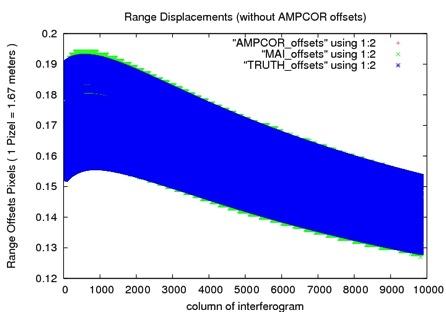
15 Range and Azimuth Displacements

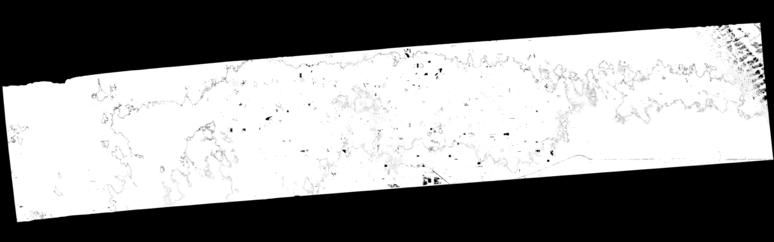

16 Examples processing sample RPI cases with MAI SanAnd_26501_ _ _0001d_s01_L090HH_02 (10027: 2 deg avg yaw, 10028: 4 deg avg yaw) ampcor MAI Near range fringing appears to be reduced. Phase variaaons closer to mean 0.

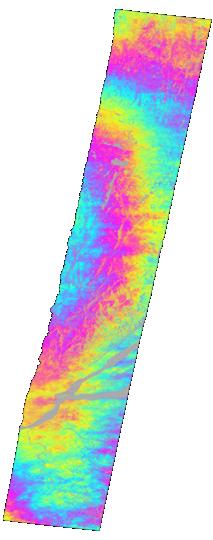

17 Examples processing sample RPI cases with MAI Laurnt_18801_ _ _0002d_s01_L090HH_01 (09054: 7 deg avg yaw, 09056: 4 deg avg yaw) ampcor MAI Smaller Residual Phase


18 Examples processing sample RPI cases with MAI harvrd_18505_ _ _0004d_s01_l090hh_01 (09060: avg - 1deg yaw, 09065: avg 9deg high yaw) ampcor MAI Near range fringing reduced


19 Examples processing sample RPI cases with MAI harvrd_18501_ _ _0001d_s01_l090hh_01 (09063: avg yaw, 09065: avg yaw) ampcor MAI Flacer interferogram
20 Summary Demonstrated that Multi-Aperture Interferometry can produce azimuth displacements comparable to amplitude correlation displacements. Method has not been adopted for production of repeat-pass interferometry at JPL. Possible advantage of MAI is that the range displacements are uncorrelated from the azimuth estimates. Range offsets come directly from unwrapped interferogram. Additional sub-banding techniques are also being investigated for improved residual motion recovery.
First TOPSAR image and interferometry results with TerraSAR-X
 First TOPSAR image and interferometry results with TerraSAR-X A. Meta, P. Prats, U. Steinbrecher, R. Scheiber, J. Mittermayer DLR Folie 1 A. Meta - 29.11.2007 Introduction Outline TOPSAR acquisition mode
AIRBORNE synthetic aperture radar (SAR) systems
 systems") IEEE GEOSCIENCE AND REMOTE SENSING LETTERS, VOL 3, NO 1, JANUARY 2006 145 Refined Estimation of Time-Varying Baseline Errors in Airborne SAR Interferometry Andreas Reigber, Member, IEEE, Pau Prats, Student
IEEE GEOSCIENCE AND REMOTE SENSING LETTERS, VOL 3, NO 1, JANUARY 2006 145 Refined Estimation of Time-Varying Baseline Errors in Airborne SAR Interferometry Andreas Reigber, Member, IEEE, Pau Prats, Student
Scene Matching on Imagery
 Scene Matching on Imagery There are a plethora of algorithms in existence for automatic scene matching, each with particular strengths and weaknesses SAR scenic matching for interferometry applications
SAR Interferometry. Dr. Rudi Gens. Alaska SAR Facility
 SAR Interferometry Dr. Rudi Gens Alaska SAR Facility 2 Outline! Relevant terms! Geometry! What does InSAR do?! Why does InSAR work?! Processing chain " Data sets " Coregistration " Interferogram generation
PSI Precision, accuracy and validation aspects
 PSI Precision, accuracy and validation aspects Urs Wegmüller Charles Werner Gamma Remote Sensing AG, Gümligen, Switzerland, wegmuller@gamma-rs.ch Contents Aim is to obtain a deeper understanding of what
ICE VELOCITY measurements are fundamentally important
 102 IEEE GEOSCIENCE AND REMOTE SENSING LETTERS, VOL. 4, NO. 1, JANUARY 2007 Synergistic Fusion of Interferometric and Speckle-Tracking Methods for Deriving Surface Velocity From Interferometric SAR Data
Lateral Ground Movement Estimation from Space borne Radar by Differential Interferometry.
 Lateral Ground Movement Estimation from Space borne Radar by Differential Interferometry. Abstract S.Sircar 1, 2, C.Randell 1, D.Power 1, J.Youden 1, E.Gill 2 and P.Han 1 Remote Sensing Group C-CORE 1
Airborne Differential SAR Interferometry: First Results at L-Band
 1516 IEEE TRANSACTIONS ON GEOSCIENCE AND REMOTE SENSING, VOL. 41, NO. 6, JUNE 2003 Airborne Differential SAR Interferometry: First Results at L-Band Andreas Reigber, Member, IEEE, and Rolf Scheiber Abstract
The 2017 InSAR package also provides support for the generation of interferograms for: PALSAR-2, TanDEM-X
 Technical Specifications InSAR The Interferometric SAR (InSAR) package can be used to generate topographic products to characterize digital surface models (DSMs) or deformation products which identify
Radar Coherent Backscatter!
 Radar Coherent Backscatter! Pixels in a radar image are a complex phasor representation of the coherent backscatter from the resolution element on the ground and the propagation phase delay! Interferometric
Memorandum. Clint Slatton Prof. Brian Evans Term project idea for Multidimensional Signal Processing (EE381k)
") Memorandum From: To: Subject: Date : Clint Slatton Prof. Brian Evans Term project idea for Multidimensional Signal Processing (EE381k) 16-Sep-98 Project title: Minimizing segmentation discontinuities in
Memorandum From: To: Subject: Date : Clint Slatton Prof. Brian Evans Term project idea for Multidimensional Signal Processing (EE381k) 16-Sep-98 Project title: Minimizing segmentation discontinuities in
MOTION COMPENSATION OF INTERFEROMETRIC SYNTHETIC APERTURE RADAR
 MOTION COMPENSATION OF INTERFEROMETRIC SYNTHETIC APERTURE RADAR David P. Duncan Microwave Earth Remote Sensing Laboratory Brigham Young University Provo, UT 84602 PH: 801.422.4884, FAX: 801.422.6586 April
A SPECTRAL ANALYSIS OF SINGLE ANTENNA INTERFEROMETRY. Craig Stringham
 A SPECTRAL ANALYSIS OF SINGLE ANTENNA INTERFEROMETRY Craig Stringham Microwave Earth Remote Sensing Laboratory Brigham Young University 459 CB, Provo, UT 84602 March 18, 2013 ABSTRACT This paper analyzes
A Correlation Test: What were the interferometric observation conditions?
 A Correlation Test: What were the interferometric observation conditions? Correlation in Practical Systems For Single-Pass Two-Aperture Interferometer Systems System noise and baseline/volumetric decorrelation
RESOLUTION enhancement is achieved by combining two
 IEEE GEOSCIENCE AND REMOTE SENSING LETTERS, VOL. 3, NO. 1, JANUARY 2006 135 Range Resolution Improvement of Airborne SAR Images Stéphane Guillaso, Member, IEEE, Andreas Reigber, Member, IEEE, Laurent Ferro-Famil,
DETECTION AND QUANTIFICATION OF ROCK GLACIER. DEFORMATION USING ERS D-InSAR DATA
 DETECTION AND QUANTIFICATION OF ROCK GLACIER DEFORMATION USING ERS D-InSAR DATA Lado W. Kenyi 1 and Viktor Kaufmann 2 1 Institute of Digital Image Processing, Joanneum Research Wastiangasse 6, A-8010 Graz,
Pixel-Offset SBAS analysis: a tool for the investigation of deformation time-series with large dynamics
 Pixel-Offset SBAS analysis: a tool for the investigation of deformation time-series with large dynamics F. Casu, A. Manconi, A. Pepe, M. Manzo, R. Lanari IREA-CNR Napoli, Italy casu.f@irea.cnr.it Summary
Three-dimensional digital elevation model of Mt. Vesuvius from NASA/JPL TOPSAR
 Cover Three-dimensional digital elevation model of Mt. Vesuvius from NASA/JPL TOPSAR G.ALBERTI, S. ESPOSITO CO.RI.S.T.A., Piazzale V. Tecchio, 80, I-80125 Napoli, Italy and S. PONTE Department of Aerospace
Interferometric Evaluation of Sentinel-1A TOPS data
 Interferometric Evaluation of Sentinel-1A TOPS data N. Yague-Martinez, F. Rodriguez Gonzalez, R. Brcic, R. Shau Remote Sensing Technology Institute. DLR, Germany ESTEC/Contract No. 4000111074/14/NL/MP/lf
SENTINEL-1 PRECISE ORBIT CALIBRATION AND VALIDATION
 SENTINEL-1 PRECISE ORBIT CALIBRATION AND VALIDATION Andrea Monti Guarnieri, Simone Mancon, and Stefano Tebaldini Politecnico di Milano, Italy ABSTRACT In this paper, we propose a model-based procedure
Individual Interferograms to Stacks
 Individual Interferograms to Stacks Piyush Agram Jet Propulsion Laboratory Aug 1, 2016 @UNAVCO Thanks to my colleagues from JPL, Caltech, Stanford University and from all over the world for providing images
Individual Interferograms to Stacks!
 Individual Interferograms to Stacks! Piyush Agram! Jet Propulsion Laboratory!! Jun 29, 2015! @UNAVCO! Thanks to my colleagues from JPL, Caltech, Stanford University and from all over the world for providing
Sentinel-1 Toolbox. TOPS Interferometry Tutorial Issued May 2014
 Sentinel-1 Toolbox TOPS Interferometry Tutorial Issued May 2014 Copyright 2015 Array Systems Computing Inc. http://www.array.ca/ https://sentinel.esa.int/web/sentinel/toolboxes Interferometry Tutorial
New Results on the Omega-K Algorithm for Processing Synthetic Aperture Radar Data
 New Results on the Omega-K Algorithm for Processing Synthetic Aperture Radar Data Matthew A. Tolman and David G. Long Electrical and Computer Engineering Dept. Brigham Young University, 459 CB, Provo,
Interferometric Synthetic-Aperture Radar (InSAR) Basics
 Basics") Interferometric Synthetic-Aperture Radar (InSAR) Basics 1 Outline SAR limitations Interferometry SAR interferometry (InSAR) Single-pass InSAR Multipass InSAR InSAR geometry InSAR processing steps Phase
Interferometric Synthetic-Aperture Radar (InSAR) Basics 1 Outline SAR limitations Interferometry SAR interferometry (InSAR) Single-pass InSAR Multipass InSAR InSAR geometry InSAR processing steps Phase
Interferometric processing. Rüdiger Gens
 Rüdiger Gens Why InSAR processing? extracting three-dimensional information out of a radar image pair covering the same area digital elevation model change detection 2 Processing chain 3 Processing chain
Repeat-pass SAR Interferometry Experiments with Gaofen-3: A Case Study of Ningbo Area
 Repeat-pass SAR Interferometry Experiments with Gaofen-3: A Case Study of Ningbo Area Tao Zhang, Xiaolei Lv, Bing Han, Bin Lei and Jun Hong Key Laboratory of Technology in Geo-spatial Information Processing
InSAR Operational and Processing Steps for DEM Generation
 InSAR Operational and Processing Steps for DEM Generation By F. I. Okeke Department of Geoinformatics and Surveying, University of Nigeria, Enugu Campus Tel: 2-80-5627286 Email:francisokeke@yahoo.com Promoting
Concept and methodology of SAR Interferometry technique
 Concept and methodology of SAR Interferometry technique March 2016 Differen;al SAR Interferometry Young s double slit experiment - Construc;ve interference (bright) - Destruc;ve interference (dark) http://media-2.web.britannica.com/eb-media/96/96596-004-1d8e9f0f.jpg
Sentinel-1 Toolbox. Interferometry Tutorial Issued March 2015 Updated August Luis Veci
 Sentinel-1 Toolbox Interferometry Tutorial Issued March 2015 Updated August 2016 Luis Veci Copyright 2015 Array Systems Computing Inc. http://www.array.ca/ http://step.esa.int Interferometry Tutorial The
Motion compensation and the orbit restitution
 InSA R Contents Introduction and objectives Pi-SAR Motion compensation and the orbit restitution InSAR algorithm DEM generation Evaluation Conclusion and future work Introduction and Objectives L-band
A STATISTICAL-COST APPROACH TO UNWRAPPING THE PHASE OF INSAR TIME SERIES
 A STATISTICAL-COST APPROACH TO UNWRAPPING THE PHASE OF INSAR TIME SERIES Andrew Hooper Delft Institute of Earth Observation and Space Systems, Delft University of Technology, Delft, Netherlands, Email:
Do It Yourself 8. Polarization Coherence Tomography (P.C.T) Training Course
 Training Course") Do It Yourself 8 Polarization Coherence Tomography (P.C.T) Training Course 1 Objectives To provide a self taught introduction to Polarization Coherence Tomography (PCT) processing techniques to enable
Do It Yourself 8 Polarization Coherence Tomography (P.C.T) Training Course 1 Objectives To provide a self taught introduction to Polarization Coherence Tomography (PCT) processing techniques to enable
NOISE SUSCEPTIBILITY OF PHASE UNWRAPPING ALGORITHMS FOR INTERFEROMETRIC SYNTHETIC APERTURE SONAR
 Proceedings of the Fifth European Conference on Underwater Acoustics, ECUA 000 Edited by P. Chevret and M.E. Zakharia Lyon, France, 000 NOISE SUSCEPTIBILITY OF PHASE UNWRAPPING ALGORITHMS FOR INTERFEROMETRIC
Filtering, unwrapping, and geocoding R. Mellors
 Filtering, unwrapping, and geocoding R. Mellors or what to do when your interferogram looks like this correlation Haiti ALOS L-band (23 cm) ascend T447, F249 3/9/09-1/25/10 azimuth phase Bperp = 780 (gmtsar)
SENTINEL-1 SUPPORT IN THE GAMMA SOFTWARE
 SENTINEL-1 SUPPORT IN THE GAMMA SOFTWARE Urs Wegmüller, Charles Werner, Tazio Strozzi, Andreas Wiesmann, Othmar Frey, and Maurizio Santoro Gamma Remote Sensing, Worbstrasse 225, 3073 Gümligen BE, Switzerland
MULTI-TEMPORAL INTERFEROMETRIC POINT TARGET ANALYSIS
 MULTI-TEMPORAL INTERFEROMETRIC POINT TARGET ANALYSIS U. WEGMÜLLER, C. WERNER, T. STROZZI, AND A. WIESMANN Gamma Remote Sensing AG. Thunstrasse 130, CH-3074 Muri (BE), Switzerland wegmuller@gamma-rs.ch,
Coherence Based Polarimetric SAR Tomography
 I J C T A, 9(3), 2016, pp. 133-141 International Science Press Coherence Based Polarimetric SAR Tomography P. Saranya*, and K. Vani** Abstract: Synthetic Aperture Radar (SAR) three dimensional image provides
Interferometry Tutorial with RADARSAT-2 Issued March 2014 Last Update November 2017
 Sentinel-1 Toolbox with RADARSAT-2 Issued March 2014 Last Update November 2017 Luis Veci Copyright 2015 Array Systems Computing Inc. http://www.array.ca/ http://step.esa.int with RADARSAT-2 The goal of
Operational process interferometric for the generation of a digital model of ground Applied to the couple of images ERS-1 ERS-2 to the area of Algiers
 Operational process interferometric for the generation of a digital model of ground Applied to the couple of images ERS-1 ERS-2 to the area of Algiers F. Hocine, M.Ouarzeddine, A. elhadj-aissa,, M. elhadj-aissa,,
DINSAR: Differential SAR Interferometry
 DINSAR: Differential SAR Interferometry Fabio Rocca 1 SAR interferometric phase: ground motion contribution If a scatterer on the ground slightly changes its relative position in the time interval between
IMPROVING DEMS USING SAR INTERFEROMETRY. University of British Columbia. ABSTRACT
 IMPROVING DEMS USING SAR INTERFEROMETRY Michael Seymour and Ian Cumming University of British Columbia 2356 Main Mall, Vancouver, B.C.,Canada V6T 1Z4 ph: +1-604-822-4988 fax: +1-604-822-5949 mseymour@mda.ca,
SAOCOM 1A INTERFEROMETRIC ERROR MODEL AND ANALYSIS
 SAOCOM A INTERFEROMETRIC ERROR MODEL AND ANALYSIS Pablo Andrés Euillades (), Leonardo Daniel Euillades (), Mario Azcueta (), Gustavo Sosa () () Instituto CEDIAC FI UNCuyo & CONICET, Centro Universitario,
Synthetic Aperture Radar Interferometry (InSAR)
") CEE 6100 / CSS 6600 Remote Sensing Fundamentals 1 Synthetic Aperture Radar Interferometry (InSAR) Adapted from and the ESA Interferometric SAR overview by Rocca et al. http://earth.esa.int/workshops/ers97/program-details/speeches/rocca-et-al/
CEE 6100 / CSS 6600 Remote Sensing Fundamentals 1 Synthetic Aperture Radar Interferometry (InSAR) Adapted from and the ESA Interferometric SAR overview by Rocca et al. http://earth.esa.int/workshops/ers97/program-details/speeches/rocca-et-al/
Ice surface velocities using SAR
 Ice surface velocities using SAR Thomas Schellenberger, PhD ESA Cryosphere Remote Sensing Training Course 2018 UNIS Longyearbyen, Svalbard 12 th June 2018 thomas.schellenberger@geo.uio.no Outline Synthetic
A Survey of Novel Airborne SAR Signal Processing Techniques and Applications for DLR s F-SAR Sensor
 A Survey of Novel Airborne SAR Signal Processing Techniques and Applications for DLR s F-SAR Sensor M. Jäger, M. Pinheiro, O. Ponce, A. Reigber, R. Scheiber Microwaves and Radar Institute, German Aerospace
SCANSAR FOCUSING AND INTERFEROMETRY
 SCNSR FOCUSING ND INTERFEROMETRY ndrea Monti Guarnieri, Claudio Prati Dipartimento di Elettronica e Informazione Politecnico di Milano Piazza L. da Vinci, 3-0133 Milano - Italy e-mail: monti@elet.polimi.it;
Improving Segmented Interferometric Synthetic Aperture Radar Processing Using Presumming. by: K. Clint Slatton. Final Report.
 Improving Segmented Interferometric Synthetic Aperture Radar Processing Using Presumming by: K. Clint Slatton Final Report Submitted to Professor Brian Evans EE381K Multidimensional Digital Signal Processing
FAST SOLUTION OF PHASE UNWRAPPING PARTIAL DIFFERENTIAL EQUATION USING WAVELETS
 Tenth MSU Conference on Differential Equations and Computational Simulations. Electronic Journal of Differential Equations, Conference 23 (2016), pp. 119 129. ISSN: 1072-6691. URL: http://ejde.math.txstate.edu
fraction of Nyquist
 differentiator 4 2.1.2.3.4.5.6.7.8.9 1 1 1/integrator 5.1.2.3.4.5.6.7.8.9 1 1 gain.5.1.2.3.4.5.6.7.8.9 1 fraction of Nyquist Figure 1. (top) Transfer functions of differential operators (dotted ideal derivative,
WIDE AREA DEFORMATION MAP GENERATION WITH TERRASAR-X DATA: THE TOHOKU-OKI EARTHQUAKE 2011 CASE
 WIDE AREA DEFORMATION MAP GENERATION WITH TERRASAR-X DATA: THE TOHOKU-OKI EARTHQUAKE 2011 CASE Nestor Yague-Martinez (1), Michael Eineder (2), Christian Minet (2), Birgitt Schättler (2) (1) Starlab Barcelona
A New Method for Correcting ScanSAR Scalloping Using Forests and inter SCAN Banding Employing Dynamic Filtering
 A New Method for Correcting ScanSAR Scalloping Using Forests and inter SCAN Banding Employing Dynamic Filtering Masanobu Shimada Japan Aerospace Exploration Agency (JAXA), Earth Observation Research Center
In addition, the image registration and geocoding functionality is also available as a separate GEO package.
 GAMMA Software information: GAMMA Software supports the entire processing from SAR raw data to products such as digital elevation models, displacement maps and landuse maps. The software is grouped into
ROI_PAC Documentation. Repeat Orbit Interferometry Package
 ROI_PAC Documentation Repeat Orbit Interferometry Package Abridged version of Chapter 3 of a PhD thesis written by Sean Buckley CSR, UT Austin; edited by Paul Rosen and Patricia Persaud May 10, 2000 Version
Challenges in Detecting & Tracking Moving Objects with Synthetic Aperture Radar (SAR)
") Challenges in Detecting & Tracking Moving Objects with Synthetic Aperture Radar (SAR) Michael Minardi PhD Sensors Directorate Air Force Research Laboratory Outline Focusing Moving Targets Locating Moving
Challenges in Detecting & Tracking Moving Objects with Synthetic Aperture Radar (SAR) Michael Minardi PhD Sensors Directorate Air Force Research Laboratory Outline Focusing Moving Targets Locating Moving
Precise coregistration of Sentinel-1A TOPS data. Heresh Fattahi, Piyush Agram, Mark Simons
 Precise coregistration of Sentinel-1A TOPS data Heresh Fattahi, Piyush Agram, Mark Simons Sentinel-1A TOPS Burst N Burst 3 Burst 2 Burst 1 [Prats-Iraola et al, 212] Swath1 Swath2 Swath3 [Sakar et al, 215]
GAMMA Interferometric Point Target Analysis Software (IPTA): Users Guide
: Users Guide") GAMMA Interferometric Point Target Analysis Software (IPTA): Users Guide Contents User Handbook Introduction IPTA overview Input data Point list generation SLC point data Differential interferogram point
GAMMA Interferometric Point Target Analysis Software (IPTA): Users Guide Contents User Handbook Introduction IPTA overview Input data Point list generation SLC point data Differential interferogram point
Motion Compensation for Airborne Interferometric Synthetic Aperture Radar
 Motion Compensation for Airborne Interferometric Synthetic Aperture Radar by DAVID ROBERT STEVENS B.A.Sc., Engineering Physics, University of British Columbia, 1989 A THESIS SUBMITTED IN PARTIAL FULFILLMENT
Radar Data Processing, Quality Analysis and Level-1b Product Generation for AGRISAR and EAGLE campaigns
 Radar Data Processing, Quality Analysis and Level-1b Product Generation for AGRISAR and EAGLE campaigns German Aerospace Center (DLR) R. Scheiber, M. Keller, J. Fischer, R. Horn, I. Hajnsek Outline E-SAR
GP265 / EE355 Homework 7 (Final project 1) Solutions
 Solutions") GP265 / EE355 Homework 7 (Final project 1) Solutions 2018-03-10 1. We form the interferogram by multiplying image S 1 and conjugated image S 2 together: S int = S 1 S 2. The multi-look version of the complex
GP265 / EE355 Homework 7 (Final project 1) Solutions 2018-03-10 1. We form the interferogram by multiplying image S 1 and conjugated image S 2 together: S int = S 1 S 2. The multi-look version of the complex
Motion Compensation of Interferometric Synthetic Aperture Radar
 Brigham Young University BYU ScholarsArchive All Theses and Dissertations 2004-07-07 Motion Compensation of Interferometric Synthetic Aperture Radar David P. Duncan Brigham Young University - Provo Follow
Upcoming altimeter measurements : nadir altimetry from Ku/C to Ka-band, SAR mode, interferometric SAR
 Upcoming altimeter measurements : nadir altimetry from Ku/C to Ka-band, SAR mode, interferometric SAR Jean-Claude Souyris CNES, Service Altimétrie & Radar Acknowledgments : Nathalie Steunou, Roger Fjortoft,
ALOS PALSAR SCANSAR INTERFEROMETRY AND ITS APPLICATION IN WENCHUAN EARTHQUAKE
 ALOS PALSAR SCANSAR INTERFEROMETRY AND ITS APPLICATION IN WENCHUAN EARTHQUAKE Cunren Liang (1) (2), Qiming Zeng (1) (2), Jianying Jia (1) (2), Jian Jiao (1) (2), Xiai Cui (1) (2) (1) (2), Xiao Zhou (1)
Interferometric SAR Signal Analysis in the Presence of Squint
 2164 IEEE TRANSACTIONS ON GEOSCIENCE AND REMOTE SENSING, VOL. 38, NO. 5, SEPTEMBER 2000 Interferometric SAR Signal Analysis in the Presence of Squint Marc Bara, Student Member, IEEE, Rolf Scheiber, Antoni
InSAR DEM; why it is better?
 InSAR DEM; why it is better? What is a DEM? Digital Elevation Model (DEM) refers to the process of demonstrating terrain elevation characteristics in 3-D space, but very often it specifically means the
Letter. Wide Band SAR Sub-Band Splitting and Inter-Band Coherence Measurements
 International Journal of Remote Sensing Vol. 00, No. 00, DD Month 200x, 1 8 Letter Wide Band SAR Sub-Band Splitting and Inter-Band Coherence Measurements D. DERAUW, A. ORBAN and Ch. BARBIER Centre Spatial
COREGISTRATION BETWEEN SAR IMAGE SUBSETS USING POINTWISE TARGETS
 COREGISTRATION BETWEEN SAR IMAGE SUBSETS USING POINTWISE TARGETS Teng Wang (1), Sigurjón Jónsson (1), Ramon Hanssen (2) (1) Division of Physical Sciences and Engineering, King Abdullah University of Science
The STUN algorithm for Persistent Scatterer Interferometry
 [1/27] The STUN algorithm for Persistent Scatterer Interferometry Bert Kampes, Nico Adam 1. Theory 2. PSIC4 Processing 3. Conclusions [2/27] STUN Algorithm Spatio-Temporal Unwrapping Network (STUN) 4 1D
3 - SYNTHETIC APERTURE RADAR (SAR) SUMMARY David Sandwell, SIO 239, January, 2008
 SUMMARY David Sandwell, SIO 239, January, 2008") 1 3 - SYNTHETIC APERTURE RADAR (SAR) SUMMARY David Sandwell, SIO 239, January, 2008 Fraunhoffer diffraction To understand why a synthetic aperture in needed for microwave remote sensing from orbital altitude
1 3 - SYNTHETIC APERTURE RADAR (SAR) SUMMARY David Sandwell, SIO 239, January, 2008 Fraunhoffer diffraction To understand why a synthetic aperture in needed for microwave remote sensing from orbital altitude
Efficient Evaluation of Fourier-Based SAR Focusing Kernels
 IEEE GEOSCIENCE AND REMOTE SENSING LETTERS 1 Efficient Evaluation of Fourier-Based SAR Focusing Kernels Pau Prats-Iraola, Senior Member, IEEE, Marc Rodriguez-Cassola, Francesco De Zan, Paco López-Dekker,
FIRST RESULTS OF THE ALOS PALSAR VERIFICATION PROCESSOR
 FIRST RESULTS OF THE ALOS PALSAR VERIFICATION PROCESSOR P. Pasquali (1), A. Monti Guarnieri (2), D. D Aria (3), L. Costa (3), D. Small (4), M. Jehle (4) and B. Rosich (5) (1) sarmap s.a., Cascine di Barico,
IDENTIFICATION OF THE LOCATION PHASE SCREEN OF ERS-ENVISAT PERMANENT SCATTERERS
 IDENTIFICATION OF THE LOCATION PHASE SCREEN OF ERS-ENVISAT PERMANENT SCATTERERS M. Arrigoni (1), C. Colesanti (1), A. Ferretti (2), D. Perissin (1), C. Prati (1), F. Rocca (1) (1) Dipartimento di Elettronica
INTEGRATED USE OF INTERFEROMETRIC SAR DATA AND LEVELLING MEASUREMENTS FOR MONITORING LAND SUBSIDENCE
 INTEGRATED USE OF INTERFEROMETRIC SAR DATA AND LEVELLING MEASUREMENTS FOR MONITORING LAND SUBSIDENCE Yueqin Zhou *, Martien Molenaar *, Deren Li ** * International Institute for Aerospace Survey and Earth
SMALL SCALE SURFACE DEFORMATION MONITORING IN MINING REGIONS USING DIFFERENTIAL RADAR INTERFEROMETRY.
 Proceedings, 11 th FIG Symposium on Deformation Measurements, Santorini, Greece, 003. SMALL SCALE SURFACE DEFORMATION MONITORING IN MINING REGIONS USING DIFFERENTIAL RADAR INTERFEROMETRY. Ireneusz Baran
THE HIGH flexibility of the TerraSAR-X (TSX) instrument
 instrument") 614 IEEE GEOSCIENCE AND REMOTE SENSING LETTERS, VOL. 9, NO. 4, JULY 2012 Scalloping Correction in TOPS Imaging Mode SAR Data Steffen Wollstadt, Pau Prats, Member, IEEE, Markus Bachmann, Josef Mittermayer,
614 IEEE GEOSCIENCE AND REMOTE SENSING LETTERS, VOL. 9, NO. 4, JULY 2012 Scalloping Correction in TOPS Imaging Mode SAR Data Steffen Wollstadt, Pau Prats, Member, IEEE, Markus Bachmann, Josef Mittermayer,
AN EFFICIENT IMAGING APPROACH FOR TOPS SAR DATA FOCUSING BASED ON SCALED FOURIER TRANSFORM
 Progress In Electromagnetics Research B, Vol. 47, 297 313, 2013 AN EFFICIENT IMAGING APPROACH FOR TOPS SAR DATA FOCUSING BASED ON SCALED FOURIER TRANSFORM Pingping Huang 1, * and Wei Xu 2 1 College of
Processing SAR data using Range Doppler and Chirp Scaling Algorithms
 Processing SAR data using Range Doppler and Chirp Scaling Algorithms Naeim Dastgir Master s of Science Thesis in Geodesy Report No. 3096 TRITA-GIT EX 07-005 School of Architecture and Built Environment
Synthetic Aperture Radar Systems for Small Aircrafts: Data Processing Approaches
 20 Synthetic Aperture Radar Systems for Small Aircrafts: Data Processing Approaches Oleksandr O. Bezvesilniy and Dmytro M. Vavriv Institute of Radio Astronomy of the National Academy of Sciences of Ukraine
Interferometric SAR Processing
 Documentation - Theory Interferometric SAR Processing Version 1.0 November 2007 GAMMA Remote Sensing AG, Worbstrasse 225, CH-3073 Gümligen, Switzerland tel: +41-31-951 70 05, fax: +41-31-951 70 08, email:
Interferometry Module for Digital Elevation Model Generation
 Interferometry Module for Digital Elevation Model Generation In order to fully exploit processes of the Interferometry Module for Digital Elevation Model generation, the European Space Agency (ESA) has
Sentinel-1 InSAR AP workshop
 Sentinel-1 InSAR AP workshop Sentinel-1 InSAR progress and experience at GAMMA U. Wegmüller, C. Werner, A. Wiesmann, T. Strozzi Gamma Remote Sensing AG - Progress made since S1A Expert Users meeting at
AMBIGUOUS PSI MEASUREMENTS
 AMBIGUOUS PSI MEASUREMENTS J. Duro (1), N. Miranda (1), G. Cooksley (1), E. Biescas (1), A. Arnaud (1) (1). Altamira Information, C/ Còrcega 381 387, 2n 3a, E 8037 Barcelona, Spain, Email: javier.duro@altamira
2003 IEEE. Personal use of this material is permitted. However, permission to reprint/republish this material for advertising or promotional purposes
 2003 IEEE. Personal use of this material is permitted. However, permission to reprint/republish this material for advertising or promotional purposes or for creating new collective works for resale or
SIMULATION AND VISUALIZATION IN THE EDUCATION OF COHERENT OPTICS
 SIMULATION AND VISUALIZATION IN THE EDUCATION OF COHERENT OPTICS J. KORNIS, P. PACHER Department of Physics Technical University of Budapest H-1111 Budafoki út 8., Hungary e-mail: kornis@phy.bme.hu, pacher@phy.bme.hu
Ship Detection and Motion Parameter Estimation with TanDEM-X in Large Along-Track Baseline Configuration
 Ship Detection and Motion Parameter Estimation with TanDEM-X in Large Along-Track Baseline Configuration SEASAR 2012 Workshop, 20.06.2012 Stefan V. Baumgartner, Gerhard Krieger Microwaves and Radar Institute,
Scene Modeling from Motion-Free Radar Sensing
 Scene Modeling from Motion-Free Radar Sensing Alex Foessel Robotics Institute Carnegie Mellon University Ph.D. Thesis Proposal May 13, 1999 Motivation - 2 - Presentation I. Research on Radar for Robots
Adaptive Doppler centroid estimation algorithm of airborne SAR
 Adaptive Doppler centroid estimation algorithm of airborne SAR Jian Yang 1,2a), Chang Liu 1, and Yanfei Wang 1 1 Institute of Electronics, Chinese Academy of Sciences 19 North Sihuan Road, Haidian, Beijing
A RESIDUE-PAIRING ALOGRITHM FOR INSAR PHASE UNWRAPPING
 Progress In Electromagnetics Research, PIER 95, 341 354, 2009 A RESIDUE-PAIRING ALOGRITHM FOR INSAR PHASE UNWRAPPING C. Li and D. Y. Zhu Department of Electronic Engineering Nanjing University of Aeronautics
Playa del Rey, California InSAR Ground Deformation Monitoring
 Playa del Rey, California InSAR Ground Deformation Monitoring Master Document Ref.: RV-14524 July 13, 2009 SUBMITTED TO: ATTN: Mr. Rick Gailing Southern California Gas Company 555 W. Fifth Street (Mail
III. TESTING AND IMPLEMENTATION
 MAPPING ACCURACY USING SIDE-LOOKING RADAR I MAGES ON TIlE ANALYTI CAL STEREOPLOTTER Sherman S.C. Wu, Francis J. Schafer and Annie Howington-Kraus U.S Geological Survey, 2255 N. Gemini Drive, Flagstaff,
An empirical model for interferometric coherence
 An empirical model for interferometric coherence Chaabane F. a, Tupin F. b and Maître H. b a URISA-SUP COM, 3.5 route de Raoued, 283 Ariana, Tunisie b GET-Télécom-Paris - CNRS URA 82, 46 rue Barrault,
Burst-Mode and ScanSAR Interferometry
 IEEE TRANSACTIONS ON GEOSCIENCE AND REMOTE SENSING, VOL. 40, NO. 9, SEPTEMBER 2002 1917 Burst-Mode and ScanSAR Interferometry Jürgen Holzner, Student Member, IEEE, and Richard Bamler, Senior Member, IEEE
INTERFEROMETRIC ISAR IMAGING ON MARITIME TARGET APPLICATIONS: SIMULATION OF REALISTIC TARGETS AND DYNAMICS
 Progress In Electromagnetics Research, Vol. 132, 571 586, 212 INTERFEROMETRIC ISAR IMAGING ON MARITIME TARGET APPLICATIONS: SIMULATION OF REALISTIC TARGETS AND DYNAMICS D. Felguera-Martín *, J. T. González-Partida,
Digital Processing of Synthetic Aperture Radar Data
 Digital Processing of Synthetic Aperture Radar Data Algorithms and Implementation Ian G. Cumming Frank H. Wong ARTECH HOUSE BOSTON LONDON artechhouse.com Contents Foreword Preface Acknowledgments xix xxiii
Design, Implementation and Performance Evaluation of Synthetic Aperture Radar Signal Processor on FPGAs
 Design, Implementation and Performance Evaluation of Synthetic Aperture Radar Signal Processor on FPGAs Hemang Parekh Masters Thesis MS(Computer Engineering) University of Kansas 23rd June, 2000 Committee:
INTERFEROMETRIC MULTI-CHROMATIC ANALYSIS OF HIGH RESOLUTION X-BAND DATA
 INTERFEROMETRIC MULTI-CHROMATIC ANALYSIS OF HIGH RESOLUTION X-BAND DATA F. Bovenga (1), V. M. Giacovazzo (1), A. Refice (1), D.O. Nitti (2), N. Veneziani (1) (1) CNR-ISSIA, via Amendola 122 D, 70126 Bari,
Study of the Effects of Target Geometry on Synthetic Aperture Radar Images using Simulation Studies
 Study of the Effects of Target Geometry on Synthetic Aperture Radar Images using Simulation Studies K. Tummala a,*, A. K. Jha a, S. Kumar b a Geoinformatics Dept., Indian Institute of Remote Sensing, Dehradun,
SAR Interferogram Phase Filtering Using Wavelet Transform
 Formatted: Font: 16 pt, Nazanin, 16 pt, (Complex) Farsi, 12 pt SAR Interferogram Phase Filtering Using Wavelet Transform V. Akbari, M. Motagh and M. A. Rajabi 1 Dept. o Surveying Eng., University College
Design and Implementation of Real-time High Squint Spotlight SAR Imaging Processor
 Chinese Journal of Electronics Vol.19, No.3, July 2010 Design and Implementation of Real-time High Squint Spotlight SAR Imaging Processor SUN Jinping 1, WANG Jun 1, HONG Wen 2 and MAO Shiyi 1 1.School
The Staggered SAR Concept: Imaging a Wide Continuous Swath with High Resolution
 The Staggered SAR Concept: Imaging a Wide Continuous Swath with High Resolution Michelangelo Villano *, Gerhard Krieger *, Alberto Moreira * * German Aerospace Center (DLR), Microwaves and Radar Institute