A New Method for Correcting ScanSAR Scalloping Using Forests and inter SCAN Banding Employing Dynamic Filtering
|
|
|
- Charity Shelton
- 5 years ago
- Views:
Transcription
1 A New Method for Correcting ScanSAR Scalloping Using Forests and inter SCAN Banding Employing Dynamic Filtering Masanobu Shimada Japan Aerospace Exploration Agency (JAXA), Earth Observation Research Center (EORC), Sengen 2-1-1, Tsukuba, Ibaraki, Japan, , Tel: , Fax: ,
2 Objectives and problem descriptions Advantages : wide swath with shorter revisit time Disadvantages: Resolution, Artifacts 1) Periodic artifacts in the azimuth direction called scalloping, 2) Truncation noise in the azimuth direction, and 3) Banding between the two neighboring scans. 2) This paper deals with effective reduction of these artifacts.
3 Image quality issues on ScanSAR are represented by the following three artifacts in the azimuth and range directions: 1)Periodic artifacts in the azimuth direction called scalloping, 2) Truncation noise in the azimuth direction, and 3) Banding between the two neighboring scans.
4 Scalloping Residual scalloping is caused by a mismatch of the real azimuth antenna pattern (AAP) and the model AAP, while the causes for the other phenomena are based on inaccurate knowledge of Doppler centroid frequency, and modulation of noise by the AAP in regions of excessively low signal-to-noise ratio (SNR). The scalloping can be suppressed if the noise floor level or the saturation rate of the SAR data is not too high and the Doppler frequency can be accurately estimated. Bamler proposed an excellent algorithm that generates an optimum weighting function by summing the different looks in such a way as to suppress the artifact for the given AAP and multiple looking intervals. Vigneron evaluated the inverse antenna pattern method and concluded that a higher SNR successfully suppressed the scalloping.
5 The Amazon Rainforest data have uniform backscattering characteristics independent of the incidence angle and are very good reference targets for SAR calibration. They are widely accepted as the major calibration sources and are used for SAR calibrations (i.e., estimation of the range antenna pattern (RAP) and monitoring radiometric calibration accuracy and sensor stabilities). However, they have not been discussed as for either especially suppressing the scalloping or the AAP estimation. Although the causes of the scalloping were clarified and a complex but sophisticated algorithm became available, a simpler algorithm could be possible either utilizing the Amazon data or creating a correction algorithm. This is the starting point of our research. Here, we propose a new method to estimate the AAP for the ScanSAR using only Amazon Rainforest data (i.e., not using the antenna pattern measured on the ground or the one measured using the receiver on the ground during satellite passage) and the errorless multi-looking method to minimize the scalloping.
6 Azimuth ambiguity The second artifact arises from signal truncation at the edge of the frequency spectrum. This can be solved by increasing the PRF so that the Doppler bandwidth of the illuminated area can be fully covered in order to satisfy the Niquist theorem. However, the parameter selection of the PRF and the number of pulses within a burst for each beam are sometimes restricted by the SAR system (i.e., some beams of Phased-Array L-band Synthetic Aperture Radar (PALSAR) on board the Advanced Land-Observing Satellite (ALOS) suffered occasionally by prioritizing the imaging swath of 350 km with five beams rather than the image quality). Thus, we propose to apply a band-limitation method.
7 Inter-Scan banding For the third artifact (i.e., banding between scans), the representative correction method, which was developed for Radarsar-1 and ENVISAT) is to update the roll angle and the Range-Dependent Gain Corrections (RDGCs) mainly using the overlap region of the two neighboring sub-swaths under the condition that the range antenna pattern (RAP) of all of the multiple beams are given. As an alternative to this approach, we propose a dynamic balancing method that was once adopted by the JERS-1 SAR mosaicking approach and has been improved to suppress the intensity discontinuity at neighboring sub-swaths. This method equalizes the intensity locally at the overlapped region and maintains the intensity in the high SNR region (i.e., the global center of the sub-swaths in the least square sense for range and azimuth directions.)
8
9 N az,k ScanSAR imaging block diagram f PRF i 1 j i 1 th burst T SCAN i f PRF f DD N az f PRF th burst v g f PRF f DD N az,k v g Unfocused burst Focused burst on the ground j i i + 1 th burst final image on the ground x x = v g T SCAN i + f PRF f DD 2 = v g T SCAN (i 1) + f PRF f DD 2 f PRF f DD N az,k j i f PRF j i 1 f DD N az,k
10 Note: All burst numbers have a zero data reception window of 12 to 1 Table 2 Look-number distribution of PALSAR/ScanSAR No. of scans Long/short burst mode Number of bursts Number of looks 3 Short 247, 356, , 9.73, Short 247, 356, 274, , 7.13, 5.44, Short 247, 356, 274, 355, , 5.35, 4.08, 5.34, Long 480, 698, , 3.94, Long 480, 698, 534, , 2.89, 2.20, Long 480, 698, 534, 696, , 2.27, 1.73, 2.21, 2.13
11 Table 4 Typical PRF (Hz) observed at WB1 5 SCAN Scan No Hokkaido Amazon Louisiana Toyama Note: Doppler bandwidths for all scans are 1700 Hz.
12 Radiometric Expression on the focused ScanSAR data P r 2 P ( k t G a X i, j )= G p ( k X i, j )G r2 λ 2 1 ρ σ 0 r ρ a ( 4π) 3 R 4 1 S a sinθ N 2 az,k N rg 2 + G p N oise N az,k N rg k X i, j k = i T SCAN v g + x i, j k x i, j = f PRF,k f DD v g 2 f PRF,k v g f DD N az,k j i,k,( j b j i,k j ) e T SCAN = N SCAN k =1 N az,k f PRF,k S r ( k X i, j )( σ 0 ) ( 4π) 3 R 4 k ( 1 S 2 k P t G ( a )sinθ P r X i, j a X i, j )G r2 λ 2 N 2 az,k N rg2 ρ r ρ a G p ( )
13 Sr,1 NL = S r Radiometric issue, Look Summation, and error expression M-1 M-2 ( X)= 1 NL 2 ()= x A %G a f PRF f DD N az f PRF S ( r x ) NL j 2 G () j =1 a x j Sr,2( X)= ( x δ,ε) 1 T SCAN %G a 2 NL S r j =1 NL 2 G a j =1 () x j () x j 2 ( x δ,ε)= 1 { 1 G a ( x δ) }1 ( ε) 2 ( 1 2ε)G a () ()+ x 2εG a ()+ x 2δ &G a x M-1 Sr,1 ( X) 1 NL NL 2ε A 1 2ε + () x + 2δ &G a 2 G a x j =1 G a () M-2 Sr,2 ( X) A 1 2ε + 2ε NL G a j =1 NL 2 G a j =1 () x () x + 2δ NL j =1 NL 2 G a j =1 &G a () x () x
14 Azimuth Antenna Pattern G a ()= x g' ( x) Kaiser Window:To limit the frequency bandwidth M 1 l =0 = a i x i W i = ( ) I 0 πα 1 ( 2k N az 1) 2 I 0 ( πα) 0 k N az 1

15


16 Truncation artifact and correction Fig. 7 ScanSAR images of an area in the Amazon with a horizontal width of 130 km do not exhibit vertical stripes for either window function.
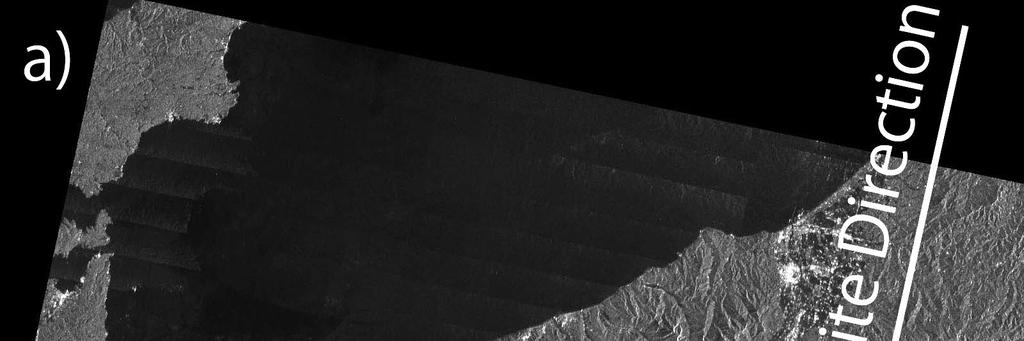
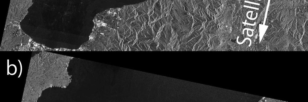
17 Truncation artifact and correction Fig. 8 ScanSAR image of an area east of Hokkaido, Japan, with a horizontal width of 130 km is depicted in two windows. The azimuth ambiguity south of the Shiretoko peninsula appearing in the red ellipse of a) is corrected by the proposed window function and thus cannot be seen in b).
18 Fig. 2 Schematic view of the SCAN-to-SCAN correction. At Step-1, the ScanSAR SAR data intensity is modeled by a quadratic equation of the slant range. In Step-2, the near range of SCAN2 is made continuous to the far range of SCAN1 with a multiplication factor. The near range of SCAN3 is made continuous to the far range of SCAN2 with a multiplication factor. Further steps will be implemented to SCAN5. In Step-3, the continuously connected line is rotated so that its center axis is aligned with that of Step-1.
19 3.1 Step-1: Gains Accumulated g l ( ) ( ) ( R)= s l +1,near R R S k, j = G k s l, far ( R)s k, j G k k l =1 ( R)= g l R ( ) 3.2 Step-2: Correction of the over/under estimation g c m ( R)= a l R l g % k C l =0 ( ) ( ) ( R)= G k R R g c 3.3 Step-3: Smoothing in azimuth k S k, j = g % C ( R) s k, j Error ( ) ( ) G ε rror = 10 log k R 10 R g c 2
20 Fig. 11 Comparison of inter SCAN banding for a PALSAR/ScanSAR image of northern Europe. Image a) is before correction; image b) is after correction.
21 Table 3 Data set used for ScanSAR analysis No. Observation Date Latitude (degrees) Longitude (degrees) 1 Nov. 24, Nov. 24, Jan. 9, Jan. 9, July 12, July 12, July 12,
22 Table 5 Gain offset by SCAN SCAN Aa (db) Ab (db) Note: Suffix ŅaÓ refers to data collected after Aug. 7, 2006, and suffix ŅbÓ refer On Aug. 7, 2006, the attenuator of the receiver was changed slightly for each data saturation rate. Table 6 Errors of the Scan-to-Scan disbanding processes Scene Average error Standard deviation Japan Amazon Amazon Sea ice Average
23 Fig. 4 Comparison of the two scalloping correction methods. Method-1 (broken line) does not correct the variation of the data over time; Method-2 (solid line) suppresses the variation of the antenna pattern. In this case, we adopted the simulation with the following parameters: =-490.2Hz/s, =1923Hz, =0.7891, =342, =0.05, and =0.0.
24 Error estimation using the following deviated antenna pattern Fig. 5 True azimuth antenna pattern (solid line) and deviated azimuth antenna pattern (broken line). The multiplicative error in the vertical antenna pattern is 5%.
25 Fig. 9 Samples of the Inter SCAN destriping process for two cases: the Amazon on the left and Japan on the right. Each has three correction curves: a thin solid line for the accumulated curve, a thin dotted curve for the calibrated curve, and a bold solid line for the final correction curve in the range direction.
26 Fig. 10 Averaged error associated with the scan-to-scan normalization for four different images.
27 Sample images produced by suing the proposed method Examples are selected from the uniform target, large variance of the scattering target, large contrasted target, and dark target Amazon Antarctica Hokkaido Sahara Desert


28 Sample images of the SCANSAR: Desert


29 Sample images of the SCANSAR:Amazon


30 Sample images of the SCANSAR:Hokkaido and O


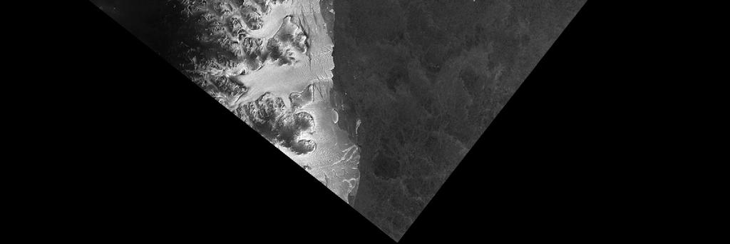
31 Sample images of the SCANSAR:Antarctica
32 Conclusions We have proposed a new method for scalloping reductions using the optimally estimated azimuth antenna pattern for the processor and using the Amazon forest target. The second method is to adopt the total weighting method to calculate the look summation of the different scans. The third method determines the gain difference of the neighboring paths balanced in range and azimuth directions.
33 Contents of this talk 1) Objectives 2) Problems 3) Scalloping 4) Inter Scan Banding 5) Examples 6) Discussions 7) Conclusions
PALSAR RADIOMETRIC AND GEOMETRIC CALIBRATION
 PALSAR RADIOMETRIC AND GEOMETRIC CALIBRATION Masanobu Shimada, Osamu Isoguchi, Takeo Tadono, and Kazuo Isono Japan Aerospace and Exploration Agency (JAXA), Earth Observation Research Center (EORC), Sengen
ALOS-2/PALSAR-2 Calibration and Validation Results
 ALOS-2/PALSAR-2 Calibration and Validation Results Ver. 2018.08.07 JAXA EORC & ALOS-2 Project Team 1 Content 1. Update of the calibration factor (CF) 2. Evaluation results for PALSAR-2 standard products
THE HIGH flexibility of the TerraSAR-X (TSX) instrument
 instrument") 614 IEEE GEOSCIENCE AND REMOTE SENSING LETTERS, VOL. 9, NO. 4, JULY 2012 Scalloping Correction in TOPS Imaging Mode SAR Data Steffen Wollstadt, Pau Prats, Member, IEEE, Markus Bachmann, Josef Mittermayer,
614 IEEE GEOSCIENCE AND REMOTE SENSING LETTERS, VOL. 9, NO. 4, JULY 2012 Scalloping Correction in TOPS Imaging Mode SAR Data Steffen Wollstadt, Pau Prats, Member, IEEE, Markus Bachmann, Josef Mittermayer,
First TOPSAR image and interferometry results with TerraSAR-X
 First TOPSAR image and interferometry results with TerraSAR-X A. Meta, P. Prats, U. Steinbrecher, R. Scheiber, J. Mittermayer DLR Folie 1 A. Meta - 29.11.2007 Introduction Outline TOPSAR acquisition mode
KALMAN FILTER FOR REMOVAL OF SCALLOPING AND INTER-SCAN BANDING IN SCANSAR IMAGES
 Progress In Electromagnetics Research, Vol. 132, 443 461, 2012 KALMAN FILTER FOR REMOVAL OF SCALLOPING AND INTER-SCAN BANDING IN SCANSAR IMAGES M. Iqbal, J. Chen *, W. Yang, P. Wang, and B. Sun School
ALOS PALSAR SCANSAR INTERFEROMETRY AND ITS APPLICATION IN WENCHUAN EARTHQUAKE
 ALOS PALSAR SCANSAR INTERFEROMETRY AND ITS APPLICATION IN WENCHUAN EARTHQUAKE Cunren Liang (1) (2), Qiming Zeng (1) (2), Jianying Jia (1) (2), Jian Jiao (1) (2), Xiai Cui (1) (2) (1) (2), Xiao Zhou (1)
Memorandum. Clint Slatton Prof. Brian Evans Term project idea for Multidimensional Signal Processing (EE381k)
") Memorandum From: To: Subject: Date : Clint Slatton Prof. Brian Evans Term project idea for Multidimensional Signal Processing (EE381k) 16-Sep-98 Project title: Minimizing segmentation discontinuities in
Memorandum From: To: Subject: Date : Clint Slatton Prof. Brian Evans Term project idea for Multidimensional Signal Processing (EE381k) 16-Sep-98 Project title: Minimizing segmentation discontinuities in
Digital Processing of Synthetic Aperture Radar Data
 Digital Processing of Synthetic Aperture Radar Data Algorithms and Implementation Ian G. Cumming Frank H. Wong ARTECH HOUSE BOSTON LONDON artechhouse.com Contents Foreword Preface Acknowledgments xix xxiii
The Staggered SAR Concept: Imaging a Wide Continuous Swath with High Resolution
 The Staggered SAR Concept: Imaging a Wide Continuous Swath with High Resolution Michelangelo Villano *, Gerhard Krieger *, Alberto Moreira * * German Aerospace Center (DLR), Microwaves and Radar Institute
Sentinel-1 Toolbox. TOPS Interferometry Tutorial Issued May 2014
 Sentinel-1 Toolbox TOPS Interferometry Tutorial Issued May 2014 Copyright 2015 Array Systems Computing Inc. http://www.array.ca/ https://sentinel.esa.int/web/sentinel/toolboxes Interferometry Tutorial
Do It Yourself 8. Polarization Coherence Tomography (P.C.T) Training Course
 Training Course") Do It Yourself 8 Polarization Coherence Tomography (P.C.T) Training Course 1 Objectives To provide a self taught introduction to Polarization Coherence Tomography (PCT) processing techniques to enable
Do It Yourself 8 Polarization Coherence Tomography (P.C.T) Training Course 1 Objectives To provide a self taught introduction to Polarization Coherence Tomography (PCT) processing techniques to enable
PALSAR-IPF SAR Data Products - Product Handbook
 PALSAR-IPF SAR Data Products Product Handbook Prepared by: A.M.Smith Phoenix Systems Reference: PALSAR-Products Issue: 2 Revision: 1 Date of issue: September 2014 Status: Issued Document type: Product
DERIVATION of the BACKSCATTERING COEFFICIENT σ o in ESA ERS SAR PRI PRODUCTS
 ERS SAR CALIBRATION DERIVATION of the BACKSCATTERING COEFFICIENT σ o in ESA ERS SAR PRI PRODUCTS H. Laur 1, P. Bally 2, P. Meadows 3, J. Sanchez 4, B. Schaettler 5, E. Lopinto 6, D. Esteban 4 Document
ALOS PALSAR. Orthorectification Tutorial Issued March 2015 Updated August Luis Veci
 ALOS PALSAR Orthorectification Tutorial Issued March 2015 Updated August 2016 Luis Veci Copyright 2015 Array Systems Computing Inc. http://www.array.ca/ http://step.esa.int ALOS PALSAR Orthorectification
IEEE JOURNAL OF SELECTED TOPICS IN APPLIED EARTH OBSERVATIONS AND REMOTE SENSING, VOL. 9, NO. 3, MARCH
 IEEE JOURNAL OF SELECTED TOPICS IN APPLIED EARTH OBSERVATIONS AND REMOTE SENSING, VOL. 9, NO. 3, MARCH 2016 1015 TerraSAR-X Staring Spotlight Mode Optimization and Global Performance Predictions Thomas
Individual Interferograms to Stacks
 Individual Interferograms to Stacks Piyush Agram Jet Propulsion Laboratory Aug 1, 2016 @UNAVCO Thanks to my colleagues from JPL, Caltech, Stanford University and from all over the world for providing images
ALOS-2 PALSAR-2 support in GAMMA Software
 ALOS-2 PALSAR-2 support in GAMMA Software Urs Wegmüller, Charles Werner, Andreas Wiesmann, Gamma Remote Sensing AG CH-3073 Gümligen, http://www.gamma-rs.ch 11-Sep-2014 1. Introduction JAXA has made available
Compression of RADARSAT Data with Block Adaptive Wavelets Abstract: 1. Introduction
 Compression of RADARSAT Data with Block Adaptive Wavelets Ian Cumming and Jing Wang Department of Electrical and Computer Engineering The University of British Columbia 2356 Main Mall, Vancouver, BC, Canada
Precise orbits and accurate timing simplifies software and enables seamless mosaicing. Geometric validation of ERS, Envisat, and ALOS.
 Geometric Calibration of GMTSAR Processing Software Using Corner Reflectors at Pinon Flat David Sandwell, UCSD/SIO CEOS Cal/Val Workshop, November 8, 2011 What is GMTSAR? Precise orbits and accurate timing
Individual Interferograms to Stacks!
 Individual Interferograms to Stacks! Piyush Agram! Jet Propulsion Laboratory!! Jun 29, 2015! @UNAVCO! Thanks to my colleagues from JPL, Caltech, Stanford University and from all over the world for providing
GEOG 4110/5100 Advanced Remote Sensing Lecture 4
 GEOG 4110/5100 Advanced Remote Sensing Lecture 4 Geometric Distortion Relevant Reading: Richards, Sections 2.11-2.17 Review What factors influence radiometric distortion? What is striping in an image?
Study of the Effects of Target Geometry on Synthetic Aperture Radar Images using Simulation Studies
 Study of the Effects of Target Geometry on Synthetic Aperture Radar Images using Simulation Studies K. Tummala a,*, A. K. Jha a, S. Kumar b a Geoinformatics Dept., Indian Institute of Remote Sensing, Dehradun,
SEA SURFACE SPEED FROM TERRASAR-X ATI DATA
 SEA SURFACE SPEED FROM TERRASAR-X ATI DATA Matteo Soccorsi (1) and Susanne Lehner (1) (1) German Aerospace Center, Remote Sensing Technology Institute, 82234 Weßling, Germany, Email: matteo.soccorsi@dlr.de
3 - SYNTHETIC APERTURE RADAR (SAR) SUMMARY David Sandwell, SIO 239, January, 2008
 SUMMARY David Sandwell, SIO 239, January, 2008") 1 3 - SYNTHETIC APERTURE RADAR (SAR) SUMMARY David Sandwell, SIO 239, January, 2008 Fraunhoffer diffraction To understand why a synthetic aperture in needed for microwave remote sensing from orbital altitude
1 3 - SYNTHETIC APERTURE RADAR (SAR) SUMMARY David Sandwell, SIO 239, January, 2008 Fraunhoffer diffraction To understand why a synthetic aperture in needed for microwave remote sensing from orbital altitude
Synthetic Aperture Radar Systems for Small Aircrafts: Data Processing Approaches
 20 Synthetic Aperture Radar Systems for Small Aircrafts: Data Processing Approaches Oleksandr O. Bezvesilniy and Dmytro M. Vavriv Institute of Radio Astronomy of the National Academy of Sciences of Ukraine
Synthetic Aperture Radar Modeling using MATLAB and Simulink
 Synthetic Aperture Radar Modeling using MATLAB and Simulink Naivedya Mishra Team Lead Uurmi Systems Pvt. Ltd. Hyderabad Agenda What is Synthetic Aperture Radar? SAR Imaging Process Challenges in Design
Experimental Radar Modes with TerraSAR-X and TanDEM-X
 Experimental Radar Modes with TerraSAR-X and TanDEM-X U. Steinbrecher 1, S. Baumgartner 1, S. Suchandt 2, S. Wollstadt 1, J. Mittermayer 1, R. Scheiber 1, D. Schulze 1, H. Breit 2 1 German Aerospace Center
MULTI-TEMPORAL SAR DATA FILTERING FOR LAND APPLICATIONS. I i is the estimate of the local mean backscattering
 MULTI-TEMPORAL SAR DATA FILTERING FOR LAND APPLICATIONS Urs Wegmüller (1), Maurizio Santoro (1), and Charles Werner (1) (1) Gamma Remote Sensing AG, Worbstrasse 225, CH-3073 Gümligen, Switzerland http://www.gamma-rs.ch,
Course Outline (1) #6 Data Acquisition for Built Environment. Fumio YAMAZAKI
 #6 Data Acquisition for Built Environment. Fumio YAMAZAKI") AT09.98 Applied GIS and Remote Sensing for Disaster Mitigation #6 Data Acquisition for Built Environment 9 October, 2002 Fumio YAMAZAKI yamazaki@ait.ac.th http://www.star.ait.ac.th/~yamazaki/ Course Outline
AT09.98 Applied GIS and Remote Sensing for Disaster Mitigation #6 Data Acquisition for Built Environment 9 October, 2002 Fumio YAMAZAKI yamazaki@ait.ac.th http://www.star.ait.ac.th/~yamazaki/ Course Outline
AN ESSENTIAL PART of SAR processing is the estimation. A Spatially Selective Approach to Doppler Estimation for Frame-Based Satellite SAR Processing
 IEEE TRANSACTIONS ON GEOSCIENCE AND REMOTE SENSING, VOL. 42, NO. 6, JUNE 2004 1135 A Spatially Selective Approach to Doppler Estimation for Frame-Based Satellite SAR Processing Ian G. Cumming, Member,
Adaptive Doppler centroid estimation algorithm of airborne SAR
 Adaptive Doppler centroid estimation algorithm of airborne SAR Jian Yang 1,2a), Chang Liu 1, and Yanfei Wang 1 1 Institute of Electronics, Chinese Academy of Sciences 19 North Sihuan Road, Haidian, Beijing
ALOS Data Service and Mission Operations
 ALOS Data Service and Mission Operations Shinichi Suzuki NASDA/EOSD ALOS Symposium @ Kogakuin Univ. March 27, 2001 Contents 1. ALOS User Service Concept 2. ALOS Data User / Distributor 3. ALOS Data Products
Phase Requirements, design and validation of phase preserving processors for a SAR system
 Phase Requirements, design and validation of phase preserving processors for a SAR system Michele Belotti (1) Silvia Scirpoli (2) Davide D Aria (1) Lorenzo Iannini (2) Andrea Monti Guarnieri (1)(2) (1)
A Short Narrative on the Scope of Work Involved in Data Conditioning and Seismic Reservoir Characterization
 A Short Narrative on the Scope of Work Involved in Data Conditioning and Seismic Reservoir Characterization March 18, 1999 M. Turhan (Tury) Taner, Ph.D. Chief Geophysicist Rock Solid Images 2600 South
Overview of MOLI data product (MOLI: Multi-footprint Observation Lidar and Imager)
") Overview of MOLI data product (MOLI: Multi-footprint Observation Lidar and Imager) Jan 7, 2016 JAXA Jumpei Murooka 1 Contents 1. Mission instruments: MOLI 2. Standard products of MOLI 3. Lidar product
Overview of MOLI data product (MOLI: Multi-footprint Observation Lidar and Imager) Jan 7, 2016 JAXA Jumpei Murooka 1 Contents 1. Mission instruments: MOLI 2. Standard products of MOLI 3. Lidar product
ENVISAT Post-Launch Products ASAR
 Page: 1 ENVISAT Post-Launch Products ASAR 1. Product Summary The following table describes all the ASAR products included in the package. The list is divided in two groups: The first part describes the
New Results on the Omega-K Algorithm for Processing Synthetic Aperture Radar Data
 New Results on the Omega-K Algorithm for Processing Synthetic Aperture Radar Data Matthew A. Tolman and David G. Long Electrical and Computer Engineering Dept. Brigham Young University, 459 CB, Provo,
AMBIGUOUS PSI MEASUREMENTS
 AMBIGUOUS PSI MEASUREMENTS J. Duro (1), N. Miranda (1), G. Cooksley (1), E. Biescas (1), A. Arnaud (1) (1). Altamira Information, C/ Còrcega 381 387, 2n 3a, E 8037 Barcelona, Spain, Email: javier.duro@altamira
Motion compensation and the orbit restitution
 InSA R Contents Introduction and objectives Pi-SAR Motion compensation and the orbit restitution InSAR algorithm DEM generation Evaluation Conclusion and future work Introduction and Objectives L-band
ALOS PALSAR VERIFICATION PROCESSOR
 ALOS PALSAR VERIFICATION PROCESSOR P. Pasquali (1), A. Monti Guarnieri (2), D. D Aria (3), L. Costa (3), D. Small (4), M. Jehle (4) and B. Rosich (5) (1) sarmap s.a., Cascine di Barico, 6989 Purasca, Switzerland,
GEOG 4110/5100 Advanced Remote Sensing Lecture 2
 GEOG 4110/5100 Advanced Remote Sensing Lecture 2 Data Quality Radiometric Distortion Radiometric Error Correction Relevant reading: Richards, sections 2.1 2.8; 2.10.1 2.10.3 Data Quality/Resolution Spatial
A SPECTRAL ANALYSIS OF SINGLE ANTENNA INTERFEROMETRY. Craig Stringham
 A SPECTRAL ANALYSIS OF SINGLE ANTENNA INTERFEROMETRY Craig Stringham Microwave Earth Remote Sensing Laboratory Brigham Young University 459 CB, Provo, UT 84602 March 18, 2013 ABSTRACT This paper analyzes
Calibration of IRS-1C PAN-camera
 Calibration of IRS-1C PAN-camera Karsten Jacobsen Institute for Photogrammetry and Engineering Surveys University of Hannover Germany Tel 0049 511 762 2485 Fax -2483 Email karsten@ipi.uni-hannover.de 1.
PSI Precision, accuracy and validation aspects
 PSI Precision, accuracy and validation aspects Urs Wegmüller Charles Werner Gamma Remote Sensing AG, Gümligen, Switzerland, wegmuller@gamma-rs.ch Contents Aim is to obtain a deeper understanding of what
Dual-Platform GMTI: First Results With The TerraSAR-X/TanDEM-X Constellation
 Dual-Platform GMTI: First Results With The TerraSAR-X/TanDEM-X Constellation Stefan V. Baumgartner, Gerhard Krieger Microwaves and Radar Institute, German Aerospace Center (DLR) Muenchner Strasse 20, 82234
Heath Yardley University of Adelaide Radar Research Centre
 Heath Yardley University of Adelaide Radar Research Centre Radar Parameters Imaging Geometry Imaging Algorithm Gamma Remote Sensing Modular SAR Processor (MSP) Motion Compensation (MoCom) Calibration Polarimetric
MODULE 3 LECTURE NOTES 3 ATMOSPHERIC CORRECTIONS
 MODULE 3 LECTURE NOTES 3 ATMOSPHERIC CORRECTIONS 1. Introduction The energy registered by the sensor will not be exactly equal to that emitted or reflected from the terrain surface due to radiometric and
An Observatory for Ocean, Climate and Environment. SAC-D/Aquarius. MWR Geometric Correction Algorithms. Felipe Madero
 An Observatory for Ocean, Climate and Environment SAC-D/Aquarius MWR Geometric Correction Algorithms Felipe Madero 7th Aquarius SAC-D Science Meeting Buenos Aires 1 April 11-13, 2012 Geometric Processing
Simulation of Brightness Temperatures for the Microwave Radiometer (MWR) on the Aquarius/SAC-D Mission. Salman S. Khan M.S. Defense 8 th July, 2009
 on the Aquarius/SAC-D Mission. Salman S. Khan M.S. Defense 8 th July, 2009") Simulation of Brightness Temperatures for the Microwave Radiometer (MWR) on the Aquarius/SAC-D Mission Salman S. Khan M.S. Defense 8 th July, 2009 Outline Thesis Objective Aquarius Salinity Measurements
Simulation of Brightness Temperatures for the Microwave Radiometer (MWR) on the Aquarius/SAC-D Mission Salman S. Khan M.S. Defense 8 th July, 2009 Outline Thesis Objective Aquarius Salinity Measurements
A Priori Knowledge-Based STAP for Traffic Monitoring Applications:
 A Priori Knowledge-Based STAP for Traffic Monitoring Applications: First Results André Barros Cardoso da Silva, German Aerospace Center (DLR), andre.silva@dlr.de, Germany Stefan Valentin Baumgartner, German
S2 MPC Data Quality Report Ref. S2-PDGS-MPC-DQR
 S2 MPC Data Quality Report Ref. S2-PDGS-MPC-DQR 2/13 Authors Table Name Company Responsibility Date Signature Written by S. Clerc & MPC Team ACRI/Argans Technical Manager 2015-11-30 Verified by O. Devignot
DEVELOPMENT OF ORIENTATION AND DEM/ORTHOIMAGE GENERATION PROGRAM FOR ALOS PRISM
 DEVELOPMENT OF ORIENTATION AND DEM/ORTHOIMAGE GENERATION PROGRAM FOR ALOS PRISM Izumi KAMIYA Geographical Survey Institute 1, Kitasato, Tsukuba 305-0811 Japan Tel: (81)-29-864-5944 Fax: (81)-29-864-2655
Calculation of beta naught and sigma naught for TerraSAR-X data
 Calculation of beta naught and sigma naught for TerraSAR-X data 1 Introduction The present document describes the successive steps of the TerraSAR-X data absolute calibration. Absolute calibration allows
In addition, the image registration and geocoding functionality is also available as a separate GEO package.
 GAMMA Software information: GAMMA Software supports the entire processing from SAR raw data to products such as digital elevation models, displacement maps and landuse maps. The software is grouped into
AN EFFICIENT IMAGING APPROACH FOR TOPS SAR DATA FOCUSING BASED ON SCALED FOURIER TRANSFORM
 Progress In Electromagnetics Research B, Vol. 47, 297 313, 2013 AN EFFICIENT IMAGING APPROACH FOR TOPS SAR DATA FOCUSING BASED ON SCALED FOURIER TRANSFORM Pingping Huang 1, * and Wei Xu 2 1 College of
Application level challenges and issues of processing different
 Application level challenges and issues of processing different sairam frequency, polarization and incidence angle Synthetic Aperture Radar data using distributed computing resources Dr. R Manavalan, Mangala
Sentinel-1 Toolbox. Interferometry Tutorial Issued March 2015 Updated August Luis Veci
 Sentinel-1 Toolbox Interferometry Tutorial Issued March 2015 Updated August 2016 Luis Veci Copyright 2015 Array Systems Computing Inc. http://www.array.ca/ http://step.esa.int Interferometry Tutorial The
RESOLUTION enhancement is achieved by combining two
 IEEE GEOSCIENCE AND REMOTE SENSING LETTERS, VOL. 3, NO. 1, JANUARY 2006 135 Range Resolution Improvement of Airborne SAR Images Stéphane Guillaso, Member, IEEE, Andreas Reigber, Member, IEEE, Laurent Ferro-Famil,
TOPSAR: Terrain Observation by Progressive Scans
 1 TOPSAR: Terrain Observation by Progressive Scans F. De Zan, A. Monti Guarnieri Dipartimento di Elettronica ed Informazione - Politecnico di Milano Piazza Leonardo Da Vinci, 32-2133 Milano - Italy tel.
Results of UAVSAR Airborne SAR Repeat-Pass Multi- Aperture Interferometry
 Results of UAVSAR Airborne SAR Repeat-Pass Multi- Aperture Interferometry Bryan Riel, Ron Muellerschoen Jet Propulsion Laboratory, California Institute of Technology 2011 California Institute of Technology.
SAR training processor
 Rudi Gens This manual describes the SAR training processor (STP) that has been developed to introduce students to the complex field of processed synthetic aperture radar (SAR) data. After a brief introduction
Geometric Rectification of Remote Sensing Images
 Geometric Rectification of Remote Sensing Images Airborne TerrestriaL Applications Sensor (ATLAS) Nine flight paths were recorded over the city of Providence. 1 True color ATLAS image (bands 4, 2, 1 in
InSAR Operational and Processing Steps for DEM Generation
 InSAR Operational and Processing Steps for DEM Generation By F. I. Okeke Department of Geoinformatics and Surveying, University of Nigeria, Enugu Campus Tel: 2-80-5627286 Email:francisokeke@yahoo.com Promoting
This is an author produced version of Accurate Reconstruction and Suppression for Azimuth Ambiguities in Spaceborne Stripmap SAR Images.
 This is an author produced version of Accurate Reconstruction and Suppression for Azimuth Ambiguities in Spaceborne Stripmap SAR Images. White Rose Research Online URL for this paper: http://eprints.whiterose.ac.uk/38/
ASCAT Verification, Calibration & Validation Plan
 ASCAT Verification, Calibration & Validation Plan Doc.No. Issue : : EUM/MET/TEN/11/0187 v1c EUMETSAT Eumetsat-Allee 1, D-64295 Darmstadt, Germany Tel: +49 6151 807-7 Fax: +49 6151 807 555 Date : 9 June
Filtering, unwrapping, and geocoding R. Mellors
 Filtering, unwrapping, and geocoding R. Mellors or what to do when your interferogram looks like this correlation Haiti ALOS L-band (23 cm) ascend T447, F249 3/9/09-1/25/10 azimuth phase Bperp = 780 (gmtsar)
Edge and local feature detection - 2. Importance of edge detection in computer vision
 Edge and local feature detection Gradient based edge detection Edge detection by function fitting Second derivative edge detectors Edge linking and the construction of the chain graph Edge and local feature
Challenges in Detecting & Tracking Moving Objects with Synthetic Aperture Radar (SAR)
") Challenges in Detecting & Tracking Moving Objects with Synthetic Aperture Radar (SAR) Michael Minardi PhD Sensors Directorate Air Force Research Laboratory Outline Focusing Moving Targets Locating Moving
Challenges in Detecting & Tracking Moving Objects with Synthetic Aperture Radar (SAR) Michael Minardi PhD Sensors Directorate Air Force Research Laboratory Outline Focusing Moving Targets Locating Moving
Empirical transfer function determination by. BP 100, Universit de PARIS 6
 Empirical transfer function determination by the use of Multilayer Perceptron F. Badran b, M. Crepon a, C. Mejia a, S. Thiria a and N. Tran a a Laboratoire d'oc anographie Dynamique et de Climatologie
Burst-Mode and ScanSAR Interferometry
 IEEE TRANSACTIONS ON GEOSCIENCE AND REMOTE SENSING, VOL. 40, NO. 9, SEPTEMBER 2002 1917 Burst-Mode and ScanSAR Interferometry Jürgen Holzner, Student Member, IEEE, and Richard Bamler, Senior Member, IEEE
SENTINEL-1 Toolbox. SAR Basics Tutorial Issued March 2015 Updated August Luis Veci
 SENTINEL-1 Toolbox SAR Basics Tutorial Issued March 2015 Updated August 2016 Luis Veci Copyright 2015 Array Systems Computing Inc. http://www.array.ca/ http://step.esa.int SAR Basics Tutorial The goal
MEASUREMENT OF SMALL TRANSVERSE BEAM SIZE USING INTERFEROMETRY
 MEASUREMENT OF SMALL TRANSVERSE BEAM SIZE USING INTERFEROMETRY T. Mitsuhashi High Energy Accelerator Research Organisation, Oho, Tsukuba, Ibaraki, 35-81 Japan Abstract The principle of measurement of the
Filtering Images. Contents
 Image Processing and Data Visualization with MATLAB Filtering Images Hansrudi Noser June 8-9, 010 UZH, Multimedia and Robotics Summer School Noise Smoothing Filters Sigmoid Filters Gradient Filters Contents
VELOCITY OPTIMIZATION METHOD OF X-BAND ANTTENA FOR JTTER ATTENUATION
 The 21 st International Congress on Sound and Vibration 13-17 July, 214, Beijing/China VELOCITY IMIZATION METHOD OF X-BAND ANTTENA FOR JTTER ATTENUATION Dae-Kwan Kim, Hong-Taek Choi Satellite Control System
Documentation - Theory. SAR Processing. Version 1.4 March 2008
 Documentation - Theory SAR Processing Version 1.4 March 2008 GAMMA Remote Sensing AG, Worbstrasse 225, CH-3073 Gümligen, Switzerland tel: +41-31-951 70 05, fax: +41-31-951 70 08, email: gamma@gamma-rs.ch
Motion Compensation in Bistatic Airborne SAR Based on a Geometrical Approach
 SAR Based on a Geometrical Approach Amaya Medrano Ortiz, Holger Nies, Otmar Loffeld Center for Sensorsystems (ZESS) University of Siegen Paul-Bonatz-Str. 9-11 D-57068 Siegen Germany medrano-ortiz@ipp.zess.uni-siegen.de
A Correlation Test: What were the interferometric observation conditions?
 A Correlation Test: What were the interferometric observation conditions? Correlation in Practical Systems For Single-Pass Two-Aperture Interferometer Systems System noise and baseline/volumetric decorrelation
Interferometry Tutorial with RADARSAT-2 Issued March 2014 Last Update November 2017
 Sentinel-1 Toolbox with RADARSAT-2 Issued March 2014 Last Update November 2017 Luis Veci Copyright 2015 Array Systems Computing Inc. http://www.array.ca/ http://step.esa.int with RADARSAT-2 The goal of
A Comparison of ALOS PALSAR-2 Calibration Data by Using External DEM
 CEOS SAR Calibration and Validation Workshop 2016 A Comparison of ALOS PALSAR-2 Calibration Data by Using External DEM Tokyo Denki University, Japan, 7 th -9 th September 2016 *Choen KIM College of Forest
G012 Scattered Ground-roll Attenuation for 2D Land Data Using Seismic Interferometry
 G012 Scattered Ground-roll Attenuation for 2D Land Data Using Seismic Interferometry D.F. Halliday* (Schlumberger Cambridge Research), P.J. Bilsby (WesternGeco), J. Quigley (WesternGeco) & E. Kragh (Schlumberger
Terrafirma: a Pan-European Terrain motion hazard information service.
 Terrafirma: a Pan-European Terrain motion hazard information service www.terrafirma.eu.com The Future of Terrafirma - Wide Area Product Nico Adam and Alessandro Parizzi DLR Oberpfaffenhofen Terrafirma
PRISM geometric Cal/Val and DSM performance
 PRISM geometric Cal/Val and DSM performance Junichi Takaku RESTEC Takeo Tadono JAXA Nov. 2008 Contents PRISM geometric Cal/Val Interior orientation parameters Exterior orientation parameters Triangulation
Radiometric Calibration of TerraSAR-X Data Beta Naught and Sigma Naught Coefficient Calculation
 Radiometric Calibration of TerraSAR-X Data Beta Naught and Sigma Naught Coefficient Calculation March 214 1/15 Introduction The present document describes TerraSAR-X data absolute calibration. Absolute
FIRST RESULTS OF THE ALOS PALSAR VERIFICATION PROCESSOR
 FIRST RESULTS OF THE ALOS PALSAR VERIFICATION PROCESSOR P. Pasquali (1), A. Monti Guarnieri (2), D. D Aria (3), L. Costa (3), D. Small (4), M. Jehle (4) and B. Rosich (5) (1) sarmap s.a., Cascine di Barico,
Design, Implementation and Performance Evaluation of Synthetic Aperture Radar Signal Processor on FPGAs
 Design, Implementation and Performance Evaluation of Synthetic Aperture Radar Signal Processor on FPGAs Hemang Parekh Masters Thesis MS(Computer Engineering) University of Kansas 23rd June, 2000 Committee:
MULTI-TEMPORAL INTERFEROMETRIC POINT TARGET ANALYSIS
 MULTI-TEMPORAL INTERFEROMETRIC POINT TARGET ANALYSIS U. WEGMÜLLER, C. WERNER, T. STROZZI, AND A. WIESMANN Gamma Remote Sensing AG. Thunstrasse 130, CH-3074 Muri (BE), Switzerland wegmuller@gamma-rs.ch,
User's Guide to NASDA's SAR products. Earth Observation research center NAtional Space Development Agency of Japan. March 10 '93 HE
 User's Guide to NASDA's SAR products Earth Observation research center NAtional Space Development Agency of Japan March 10 '93 HE-930014 Revision - 0 Revision - 1 Feb. 16, 1998 1 Title: User's Guide to
Repeat-pass SAR Interferometry Experiments with Gaofen-3: A Case Study of Ningbo Area
 Repeat-pass SAR Interferometry Experiments with Gaofen-3: A Case Study of Ningbo Area Tao Zhang, Xiaolei Lv, Bing Han, Bin Lei and Jun Hong Key Laboratory of Technology in Geo-spatial Information Processing
Range Imaging Through Triangulation. Range Imaging Through Triangulation. Range Imaging Through Triangulation. Range Imaging Through Triangulation
 Obviously, this is a very slow process and not suitable for dynamic scenes. To speed things up, we can use a laser that projects a vertical line of light onto the scene. This laser rotates around its vertical
MOTION COMPENSATION OF INTERFEROMETRIC SYNTHETIC APERTURE RADAR
 MOTION COMPENSATION OF INTERFEROMETRIC SYNTHETIC APERTURE RADAR David P. Duncan Microwave Earth Remote Sensing Laboratory Brigham Young University Provo, UT 84602 PH: 801.422.4884, FAX: 801.422.6586 April
A GLOBAL BACKSCATTER MODEL FOR C-BAND SAR
 A GLOBAL BACKSCATTER MODEL FOR C-BAND SAR Daniel Sabel (1), Marcela Doubková (1), Wolfgang Wagner (1), Paul Snoeij (2), Evert Attema (2) (1) Vienna University of Technology, Institute of Photogrammetry
Three-dimensional digital elevation model of Mt. Vesuvius from NASA/JPL TOPSAR
 Cover Three-dimensional digital elevation model of Mt. Vesuvius from NASA/JPL TOPSAR G.ALBERTI, S. ESPOSITO CO.RI.S.T.A., Piazzale V. Tecchio, 80, I-80125 Napoli, Italy and S. PONTE Department of Aerospace
Improving Segmented Interferometric Synthetic Aperture Radar Processing Using Presumming. by: K. Clint Slatton. Final Report.
 Improving Segmented Interferometric Synthetic Aperture Radar Processing Using Presumming by: K. Clint Slatton Final Report Submitted to Professor Brian Evans EE381K Multidimensional Digital Signal Processing
Sentinel-1 processing with GAMMA software
 Documentation User s Guide Sentinel-1 processing with GAMMA software Including an example of Sentinel-1 SLC co-registration and differential interferometry Version 1.1 May 2015 GAMMA Remote Sensing AG,
Anno accademico 2006/2007. Davide Migliore
 Robotica Anno accademico 6/7 Davide Migliore migliore@elet.polimi.it Today What is a feature? Some useful information The world of features: Detectors Edges detection Corners/Points detection Descriptors?!?!?
Anisotropic model building with well control Chaoguang Zhou*, Zijian Liu, N. D. Whitmore, and Samuel Brown, PGS
 Anisotropic model building with well control Chaoguang Zhou*, Zijian Liu, N. D. Whitmore, and Samuel Brown, PGS Summary Anisotropic depth model building using surface seismic data alone is non-unique and
Radiometric Calibration of S-1 Level-1 Products Generated by the S-1 IPF
 Radiometric Calibration of S-1 Level-1 Products Generated by the S-1 IPF Prepared by Nuno Miranda, P.J. Meadows Reference ESA-EOPG-CSCOP-TN-0002 Issue 1 Revision 0 Date of Issue 21/05/2015 Status Final
Geometric Accuracy Evaluation, DEM Generation and Validation for SPOT-5 Level 1B Stereo Scene
 Geometric Accuracy Evaluation, DEM Generation and Validation for SPOT-5 Level 1B Stereo Scene Buyuksalih, G.*, Oruc, M.*, Topan, H.*,.*, Jacobsen, K.** * Karaelmas University Zonguldak, Turkey **University
Modular SAR Processor - MSP
 Documentation User s Guide Version 1.10 November 2015 GAMMA Remote Sensing AG, Worbstrasse 225, CH-3073 Gümligen, Switzerland tel: +41-31-951 70 05, fax: +41-31-951 70 08, email: gamma@gamma-rs.ch Table
Processing techniques for a GNSS-R scatterometric remote sensing instrument
 Processing techniques for a GNSS-R scatterometric remote sensing instrument Philip J. Jales (1) Martin Unwin (2) Craig Underwood (1) (1) Surrey Space Centre, University Of Surrey, UK (2) Satellite Technology