OBLIQUE AERIAL IMAGES: POTENTIALITIES, APPLICATIONS AND BEST PRACTICES FRANCESCO NEX
|
|
|
- Percival Singleton
- 5 years ago
- Views:
Transcription


1 OBLIQUE AERIAL IMAGES: POTENTIALITIES, APPLICATIONS AND BEST PRACTICES FRANCESCO NEX
 was an oblique shot from a balloon. In 1906 G. R.")
 after the strong earthquake in the")
2 The history of oblique imagery First recorded aerial photo in the US (1860) by J.W. Black and S. King in Boston (USA) was an oblique shot from a balloon. In 1906 G. R. Lawrence used between nine and seventeen large kites to lift a huge camera and take some oblique aerial images of San Francisco (USA) after the strong earthquake in the area


3 The history of oblique imagery Oblique cameras on airplanes gained importance for military reconnaissance during World War I and World War 2. However, these systems were too expensive in the analogue times. Oblique systems were re-introduced on the market by Pictometry more than 10 years ago Zeiss twin RMK USGC-9 Fairchild T-3A


4 Current oblique camera systems Swiping camera Different solutions are nowadays available on the market, adopting: Different number of cameras Different acquisition geometries Single swiping camera FAN ACQUISITION


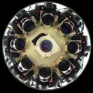

5 Current oblique camera systems Multi-camera 2 cameras 3 cameras 4 cameras IGI Dual n-cameras DLR-3K IGI Digicam 4 Rolleimetric AIC x4 MIDAS Optoblique


6 Current oblique camera systems Multi-camera 5 cameras MALTESE CROSS CONFIGURATION Vexcel Osprey Leica RCD 30 IGI Penta DigiCAM One nadir + 4 oblique cameras Modular (i.e. varying angles) vs fixed Small, medium or large format sensors RGB + NIR (in the nadir) Wide vs narrow angle lens


7 Questionnaire submitted by EuroSDR on the current status of oblique airborne imagery Run throughout 2014 and participants Who is interested in the oblique systems? Advantages of oblique imagery?

 Source: BlomUrbex Source: Xiao,")
8 First applications / use of oblique images Monoplotting / Building height measurements Interactive city modeling (Imagemodeler + Blomoblique) Source: BlomUrbex Source: Xiao, 2013
9 Nadir vs Oblique images and Photogrammetry VERTICAL: Good observation of roofs, constant scale, traditional approach OBLIQUE Pros / Benefits: Visibility of roofs and vertical structures (feat. extraction, texturing) Multiple views, including nadir Better interpretation (building footprints, number of floors, etc.) Higher redundancy & reliability 3D vs 2.5D point clouds more detailed 3D city models Improvement of the true-orthophoto automated generation OBLIQUE CONS: More occlusions (mitigated by multiple views and overlaps) Varying scale / GSD Big illumination changes Need for dedicated processing

 Airborne (nadir/oblique)")
 Dense image matching within/across")


10 Photogrammetric use of oblique image The photogrammetric use of oblique images is challenging researchers / companies interest Many papers and initiatives dealing with oblique imagery are already available Terrestrial image blocks UAV (nadir/oblique) Airborne (nadir/oblique) Foster research concerning: 1) Fully automatic and reliable orientation of multi platform imagery 2) Dense image matching within/across platforms [F. Nex, F., Gerke, M., Remondino, F., Przybilla, H.-J., Bäumker, M., Zurhorst, A., 2015: ISPRS benchmark for multi-platform photogrammetry. ISPRS Annals of the Photogrammetry, Remote Sensing and Spatial Information Sciences, Vol. II-3/W4, pp PIA15+HRIGI15 Joint ISPRS conference]


 Nadir Nadir &")
11 Data Collection State-of-the-art is 5 images for every acquisition position Large image block size (# images) Nadir Nadir & oblique Source: Ordnance and Survey UK


12 Data Collection Choose the right overlaps if a complete 3D model of the urban area is needed The street s width and the building s height play a major role in planning a successful urban survey campaign. The taller the architectures, the lower the camera incidence angle must be. A compromise should be found between the camera tilt setting, focal length, sensor size, overlap and geometry of the area. [Rupnik, E., Nex, F., Toschi, I., Remondino, F., 2015: Aerial multi-camera systems: Accuracy and block triangulation issues. ISPRS Journal of Photogrammetry and Remote Sensing, Vol. 101, pp ]

13 Data Processing Image orientation Problems for traditional photogrammetric tools / approaches: Convergent images Varying image scale / resolution (GCPs measured with diff. accuracy) Large perspective distortions (interest operators are less efficient) Long processing time


14 Data processing image orientation Different perspectives and illuminations in different image views


15 Data processing image orientation The final results will be many (separated) blocks, without a good strategy of concatenation of the images. Right Back Front Left Nadir Right Back Front Left Nadir The traditional approaches lose the connection between different sub-blocks acquired from different looking directions [Gerke, M., F. Nex, F. Remondino, K. Jacobsen, J. Kremer, W. Karel, H. Hu, W. Ostrowski, Orientation of oblique airborne image sets - experiences from the ISPRS/EUROSDR benchmark on multi-platform photogrammetry, ISPRS Archives, to be published]


16 Data processing image orientation Rely on GNSS/INS data Create a connectivity map/graph Use constraints like: overlap, looking direction, min num. of extracted tie points Exploit large observations redundancy [Rupnik, E., Nex, F., Remondino, F., 2013: Automatic orientation of large blocks of oblique images. ISPR Archives of the Photogrammetry, Remote Sensing and Spatial Information Sciences, ISPRS Hannover 2013]
17 Data processing Point cloud generation Use connectivity map/graph Use only images with same look direction and large overlaps in the matching process [Rupnik, E., Nex, F., and Remondino, F., 2014: Oblique multi-camera systems - orientation and dense matching issues. ISPRS Archives of the Photogrammetry, Remote Sensing and Spatial Information Sciences, XL-3/W1, pp ]
 1 view 2 views 4 views")

18 Data processing Point cloud generation Use connectivity map/graph Prefer images with same look direction Point cloud filtering Merge multiple point clouds (from every looking direction) 1 view 2 views 4 views [Rupnik, E., Nex, F., and Remondino, F., 2014: Oblique multi-camera systems - orientation and dense matching issues. ISPRS Archives of the Photogrammetry, Remote Sensing and Spatial Information Sciences, XL-3/W1, pp ]

19 Data processing Point cloud generation Dense Image Matching point cloud (MicMac)


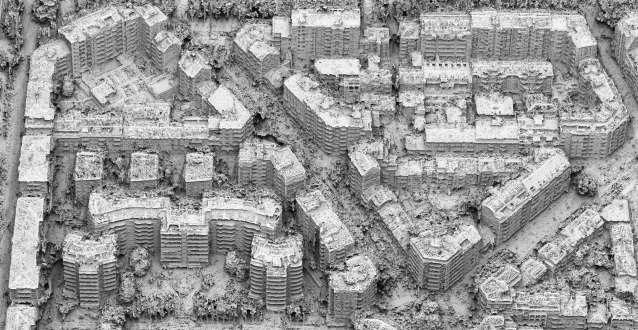
20 Data processing point cloud generatio Dortmund dataset (IGI PentaCam) ISPRS/EuroSDR benchmark GSD 10cm > 1000 images Courtesy: nframe [Haala, N., Rothermel, M. & Cavegn, S., Extracting 3D Urban Models from Oblique Aerial Images. JURSE 2015 Joint Urban Remote Sensing Event, Lausanne, Switzerland]

21 Courtesy: nframe

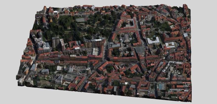
22 Data processing True-ortho generation Courtesy: nframe

23 Applications - 3D mesh / polygonal models Source: Toschi and Remondino, 2015


24 Applications - 3D building models Point cloud Roof segmentation and classification Building models Source: Toschi and Remondino, 2015


25 Applications Urban Monitoring L Aquila earthquake Automated delineation of damages [Vetrivel, A., Duarte, D., Nex, F., Gerke, M., Kerle, N., Vosselman, G., Potential of multi-temporal oblique airborne imagery for structural damage assessment. ISPRS Annals, to be published]

26 Applications Cadastral monitoring Number of floors Building footprints [Remondino, F., Toschi, I., Gerke, M., Nex, F., Holland, D., McGill, A., Talaya Lopez, J., Magarinos, A., Oblique aerial imagery for NMA Some best practices. ISPRS Archieves, to be published]


27 Early NMCA experiences Ordnance & Survey UK Classification 3D building model without prior knowledge Ordnance & Survey Ireland Map updating and systematic comparison existing methologies
 No need building footprint for 3D city modelling More accurate modelling Texture and additional information of façades Huge amount of data to be")
28 Institut Cartogràfic i Geològic de Catalunya Texturing 3D models and visual inspection Early NMCA experiences General remarks Use of available commercial solutions (i.e. Tridicon) No need building footprint for 3D city modelling More accurate modelling Texture and additional information of façades Huge amount of data to be managed
29 Final remarks and outlook Many systems and new ones might come out soon (sensor size?) Oblique requires a new approach in the photogrammetric pipeline Oblique airborne images could become a standard, complementary to traditional large format nadir images (especially in urban areas) Oblique are complementary to traditional nadir and UAV images Many possible applications: map update, 3D city modeling, inspection and interpretation, 3D cadaster, real estate, etc. NMCAs are thinking to adjust their production pipeline to cope with oblique Additional costs of oblique flights (especially additional flight lines) might be compensated by additional outcomes and benefits: Easier object identification / interpretation generation of point clouds on vertical elements More reliable generation of true-orthophotos Extension from 2D to 3D GIS data
 Feature extraction and automation in")
30 Final remarks and outlook Room for improvement in the use of oblique imagery: Management of scale and radiometric changes; Reliable and fast identification of homologues points, also across viewing directions; Processing time and reliable big-data processing Fusion of point clouds coming from different viewing directions (and with different accuracy) Feature extraction and automation in interpretation in complex scenes Integration of Oblique images with other data (UAV, MMS)
31 OBLIQUE AERIAL IMAGES: POTENTIALITIES, APPLICATIONS AND BEST PRACTICES FRANCESCO NEX Acknowledgements: Markus Gerke (ITC, The Netherlands), Fabio Remondino (FBK, Italy), Ordnance & Survey UK, Ordnance & Survey Ireland and Institut Cartogràfic i Geològic de Catalunya
OBLIQUE AERIAL IMAGERY FOR NMA SOME BEST PRACTICES
 OBLIQUE AERIAL IMAGERY FOR NMA SOME BEST PRACTICES F. Remondino 1, I. Toschi 1, M. Gerke 2, F. Nex 2, D. Holland 3, A. McGill 4, J. Talaya Lopez 5, A. Magarinos 5 1 3D Optical Metrology (3DOM) unit, Bruno
OBLIQUE AERIAL IMAGERY A REVIEW
 OBLIQUE AERIAL IMAGERY A REVIEW FABIO REMONDINO 3D Optical Metrology unit Bruno Kessler Foundation (FKB) Trento, Italy http://3dom.fbk.eu Email: remondino@fbk.eu MARKUS GERKE EOS dept. ITC / Univ. Twente,
STATUS OF AIRBORNE OBLIQUE IMAGING EUROSDR COMMISSION I PROJECT OBLIQUE IMAGERY. Markus Gerke May 15, 2014
 STATUS OF AIRBORNE OBLIQUE IMAGING EUROSDR COMMISSION I PROJECT OBLIQUE IMAGERY Markus Gerke May 15, 2014 THE FIRST AIRBORNE PHOTOS WERE OBLIQUE First recorded aerial photograph in the US (Boston), by
ISPRS Benchmark for Multi-Platform Photogrammetry
 ISPRS Benchmark for Multi-Platform Photogrammetry Francesco Nex (FBK) Markus Gerke (University of Twente/ITC) Fabio Remondino (FBK) Heinz-Jürgen Przybilla (HS Bochum) Manfred Bäumker (HS Bochum) Alexander
THE ISPRS/EUROSDR BENCHMARK ON MULTI-PLATFORM PHOTOGRAMMETRY: RESULTS AND LESSON LEARNT FRANCESCO NEX AND MARKUS GERKE
 THE ISPRS/EUROSDR BENCHMARK ON MULTI-PLATFORM PHOTOGRAMMETRY: RESULTS AND LESSON LEARNT FRANCESCO NEX AND MARKUS GERKE Overview Summary of the results Statistics Data release What s next? ISPRS / EuroSDR
HIGH DENSITY AERIAL IMAGE MATCHING: STATE-OF-THE-ART AND FUTURE PROSPECTS
 HIGH DENSITY AERIAL IMAGE MATCHING: STATE-OF-THE-ART AND FUTURE PROSPECTS N. Haala a *, S. Cavegn a, b a Institute for Photogrammetry, University of Stuttgart, Germany - norbert.haala@ifp.uni-stuttgart.de
CURRENT DEVELOPMENTS IN AIRBORNE OBLIQUE IMAGING SYSTEMS AND AUTOMATED INTERPRETATION OF COMPLEX BUILDINGS. Markus Gerke
 CURRENT DEVELOPMENTS IN AIRBORNE OBLIQUE IMAGING SYSTEMS AND AUTOMATED INTERPRETATION OF COMPLEX BUILDINGS Markus Gerke THE FIRST AIRBORNE PHOTOS WERE OBLIQUE First recorded aerial photograph in the US
USE OF VERTICAL AERIAL IMAGES FOR SEMI-OBLIQUE MAPPING
 USE OF VERTICAL AERIAL IMAGES FOR SEMI-OBLIQUE MAPPING D. Poli a, K. Moe a, K. Legat b, I. Toschi b, F. Lago b, F. Remondino b a Terra Messflug GmbH, Eichenweg 42, 6460 Imst, Austria (k.moe, d.poli)@terra-messflug.at
ACCURACY OF MEASUREMENTS IN OBLIQUE AERIAL IMAGES FOR URBAN ENVIRONMENT
 The International Archives of the Sciences, Volume XLII-2/W2, 2016 ACCURACY OF MEASUREMENTS IN OBLIQUE AERIAL IMAGES FOR URBAN ENVIRONMENT W. Ostrowski Department of Systems, Faculty of Geodesy and Cartography,
1. Introduction. A CASE STUDY Dense Image Matching Using Oblique Imagery Towards All-in- One Photogrammetry
 Submitted to GIM International FEATURE A CASE STUDY Dense Image Matching Using Oblique Imagery Towards All-in- One Photogrammetry Dieter Fritsch 1, Jens Kremer 2, Albrecht Grimm 2, Mathias Rothermel 1
Oblique aerial imagery in the praxis: applications and challenges
 ISPRS / EuroSDR Workshop on Oblique aerial cameras sensors and data processing Barcelona, 10 October 2017 Oblique aerial imagery in the praxis: applications and challenges Daniela Poli, Kjersti Moe, Klaus
REPORT OF THE SCIENTIFIC INITIATIVE
 Bruno Kessler Foundation (FBK) 3D Optical Metrology Unit (3DOM) Via Sommarive 18, Trento, Italy http://3dom.fbk.eu ISPRS BENCHMARK FOR MULTI-PLATFORM PHOTOGRAMMETRY REPORT OF THE SCIENTIFIC INITIATIVE
Automated Processing for 3D Mosaic Generation, a Change of Paradigm
 Automated Processing for 3D Mosaic Generation, a Change of Paradigm Frank BIGNONE, Japan Key Words: 3D Urban Model, Street Imagery, Oblique imagery, Mobile Mapping System, Parallel processing, Digital
Oblique aerial photography viewer and monoplotting tool for building façade inspection and disaster assessment
 Oblique aerial photography viewer and monoplotting tool for building façade inspection and disaster assessment Arnadi Murtiyoso Department of Topography INSA Strasbourg, France arnadi.murtiyoso@insa-strasbourg.fr
Image-based 3D Data Capture in Urban Scenarios
 Photogrammetric Week '15 Dieter Fritsch (Ed.) Wichmann/VDE Verlag, Belin & Offenbach, 2015 Haala, Rothermel 119 Image-based 3D Data Capture in Urban Scenarios Norbert Haala, Mathias Rothermel, Stuttgart
Multi-ray photogrammetry: A rich dataset for the extraction of roof geometry for 3D reconstruction
 Multi-ray photogrammetry: A rich dataset for the extraction of roof geometry for 3D reconstruction Andrew McClune, Pauline Miller, Jon Mills Newcastle University David Holland Ordnance Survey Background
POINT CLOUD ACQUISITION & STRUCTURING
 Point Cloud Processing 2018 March 13th, 2018 TU Delft, the Netherlands POINT CLOUD ACQUISITION & STRUCTURING Fabio REMONDINO 3D Optical Metrology (3DOM) Bruno Kessler Foundation (FBK) Trento, Italy Email:
Vexcel Imaging Ve V x e c x el e I l maging I G maging mbh www. wwwv. e v x e c x e c l e -limaging. - c imaging. om c
 Vexcel Imaging History 2016 MBO: becomes a privately owned company again 2006 Vexcel Imaging acquired by Microsoft Corp., Redmond/USA 2003 1992 1985 Merger of Vexcel Corp. & Vexcel Imaging 1 st Digital
3D recording of archaeological excavation
 5 th International Conference Remote Sensing in Archaeology The Age of Sensing 13-15 October 2014 - Duke University 3D recording of archaeological excavation Stefano Campana UNIVERSITY of CAMBRIDGE Faculty
UAV-BASED DAMAGE MAPPING AND THE FP7-PROJECT RECONASS
 UAV-BASED DAMAGE MAPPING AND THE FP7-PROJECT RECONASS Norman Kerle. ESA Department ITC-OOA-Group (with materials by Markus Gerke, Jorge Fernandez and Anand Vetrivel) ITC/ University Twente International
STATE-OF-THE-ART in DENSE IMAGE MATCHING
 STATE-OF-THE-ART in DENSE IMAGE MATCHING Fabio REMONDINO 3D Optical Metrology (3DOM) Bruno Kessler Foundation (FBK) Trento, Italy Email: remondino@fbk.eu http://3dom.fbk.eu Bruno Kessler Foundation (FBK)
The Leica Geosystems CityMapper Solution
 Photogrammetric Week '13 Dieter Fritsch (Ed.) Wichmann/VDE Verlag, Belin & Offenbach, 2013 Wagner et al. 89 The Leica Geosystems CityMapper Solution RUEDIGER WAGNER, Heerbrugg, Switzerland PETER LIECKFELDT,
THE USE OF UAVS FOR EARTH OBSERVATION FRANCESCO NEX
 THE USE OF UAVS FOR EARTH OBSERVATION FRANCESCO NEX f.nex@utwente.nl Overview Why UAVs for Earth Observation? Unmanned Aerial Vehicles classification Photogrammetric pipeline with UAVs Current applications
The use of different data sets in 3-D modelling
 The use of different data sets in 3-D modelling Ahmed M. HAMRUNI June, 2014 Presentation outlines Introduction Aims and objectives Test site and data Technology: Pictometry and UltraCamD Results and analysis
Assessing the Performance of Different Direct-Georeferencing with Large Format Digital Cameras
 Assessing the Performance of Different Direct-Georeferencing with Large Format Digital Cameras Civil and Environment Engineering Department, Mu ta University, Mu ta, Al-Karak, Jordan, 61710. E.mail: khaldoun_q@hotamil.com
2-in-1 Large Format and Oblique Aerial Camera Systems for 3D Urban Mapping. Philipp Grimm EUROSDR/ISPRS Workshop Oblique, Barcelona,
 2-in-1 Large Format and Oblique Aerial Camera Systems for 3D Urban Mapping Philipp Grimm EUROSDR/ISPRS Workshop Oblique, Barcelona, 09.10.2017 Mission Planning & Flight Guidance Sensor Management GNSS/IMU
Oblique Image Processing in SURE - First Experiments and Results
 EuroSDR / ISPRS Workshop, Southampton 2015 Oblique Image Processing in SURE - First Experiments and Results Mathias Rothermel Outline» General Workflow» 2.5D Meshing» Mesh Texturing» 3D Workflow» First
Mayden VP of Business Development Surdex Corporation
 Making Sense of Sensors Randy Mayden, Mayden VP of Business Development Surdex Corporation randym@surdex.com EARLYAERIAL PHOTOGRAPHY 2 FIRSTAERIAL CAMERA 3 AERIAL CAMERA SYSTEM DEVELOPMENT Aerial Camera
Automatic image network design leading to optimal image-based 3D models
 Automatic image network design leading to optimal image-based 3D models Enabling laymen to capture high quality 3D models of Cultural Heritage Bashar Alsadik & Markus Gerke, ITC, University of Twente,
Reality Modeling Drone Capture Guide
 Reality Modeling Drone Capture Guide Discover the best practices for photo acquisition-leveraging drones to create 3D reality models with ContextCapture, Bentley s reality modeling software. Learn the
THE INTERIOR AND EXTERIOR CALIBRATION FOR ULTRACAM D
 THE INTERIOR AND EXTERIOR CALIBRATION FOR ULTRACAM D K. S. Qtaishat, M. J. Smith, D. W. G. Park Civil and Environment Engineering Department, Mu ta, University, Mu ta, Karak, Jordan, 61710 khaldoun_q@hotamil.com
BUNDLE BLOCK ADJUSTMENT WITH HIGH RESOLUTION ULTRACAMD IMAGES
 BUNDLE BLOCK ADJUSTMENT WITH HIGH RESOLUTION ULTRACAMD IMAGES I. Baz*, G. Buyuksalih*, K. Jacobsen** * BIMTAS, Tophanelioglu Cad. ISKI Hizmet Binasi No:62 K.3-4 34460 Altunizade-Istanbul, Turkey gb@bimtas.com.tr
Multiray Photogrammetry and Dense Image. Photogrammetric Week Matching. Dense Image Matching - Application of SGM
 Norbert Haala Institut für Photogrammetrie Multiray Photogrammetry and Dense Image Photogrammetric Week 2011 Matching Dense Image Matching - Application of SGM p q d Base image Match image Parallax image
PERFORMANCE ANALYSIS OF FAST AT FOR CORRIDOR AERIAL MAPPING
 PERFORMANCE ANALYSIS OF FAST AT FOR CORRIDOR AERIAL MAPPING M. Blázquez, I. Colomina Institute of Geomatics, Av. Carl Friedrich Gauss 11, Parc Mediterrani de la Tecnologia, Castelldefels, Spain marta.blazquez@ideg.es
The Topographic Data Deluge Collecting and Maintaining Data in a 21 st Century Mapping Agency
 The Topographic Data Deluge Collecting and Maintaining Data in a 21 st Century Mapping Agency D. A. Holland a*, C. Pook a, D. Capstick a, A. Hemmings a a Ordnance Survey, Adanac Drive, Southampton SO16
Presented at the FIG Congress 2018, May 6-11, 2018 in Istanbul, Turkey
 Presented at the FIG Congress 2018, May 6-11, 2018 in Istanbul, Turkey Evangelos MALTEZOS, Charalabos IOANNIDIS, Anastasios DOULAMIS and Nikolaos DOULAMIS Laboratory of Photogrammetry, School of Rural
Segmentation of 3D Photogrammetric Point Cloud for 3D Building Modeling
 Segmentation of 3D Photogrammetric Point Cloud for 3D Building Modeling EMRE ÖZDEMİR 1,2, Fabio Remondino 1 1 3D Optical Metrology unit Bruno Kessler Foundation (FBK) Trento, Italy https://3dom.fbk.eu
PERFORMANCE OF LARGE-FORMAT DIGITAL CAMERAS
 PERFORMANCE OF LARGE-FORMAT DIGITAL CAMERAS K. Jacobsen Institute of Photogrammetry and GeoInformation, Leibniz University Hannover, Germany jacobsen@ipi.uni-hannover.de Inter-commission WG III/I KEY WORDS:
EVALUATION OF WORLDVIEW-1 STEREO SCENES AND RELATED 3D PRODUCTS
 EVALUATION OF WORLDVIEW-1 STEREO SCENES AND RELATED 3D PRODUCTS Daniela POLI, Kirsten WOLFF, Armin GRUEN Swiss Federal Institute of Technology Institute of Geodesy and Photogrammetry Wolfgang-Pauli-Strasse
Introduction. Acute3D S.A.S. WTC Valbonne Sophia Antipolis. 120 route des Macarons.
 Introduction This benchmark compares the performances of the three main photo-based 3Dmodeling software. Five projects related to different kind of applications were led on the same machine and this document
GENERATING BUILDING OUTLINES FROM TERRESTRIAL LASER SCANNING
 GENERATING BUILDING OUTLINES FROM TERRESTRIAL LASER SCANNING Shi Pu International Institute for Geo-information Science and Earth Observation (ITC), Hengelosestraat 99, P.O. Box 6, 7500 AA Enschede, The
EVOLUTION OF POINT CLOUD
 Figure 1: Left and right images of a stereo pair and the disparity map (right) showing the differences of each pixel in the right and left image. (source: https://stackoverflow.com/questions/17607312/difference-between-disparity-map-and-disparity-image-in-stereo-matching)
INCORPORATING SCENE CONSTRAINTS INTO THE TRIANGULATION OF AIRBORNE OBLIQUE IMAGES
 INCORPORATING SCENE CONSTRAINTS INTO THE TRIANGULATION OF AIRBORNE OBLIQUE IMAGES M. Gerke and A.P. Nyaruhuma International Institute for Geo-Information Science and Earth Observation ITC, Department of
GEOMETRY AND INFORMATION CONTENTS OF LARGE SIZE DIGITAL FRAME CAMERAS
 GEOMETRY AND INFORMATION CONTENTS OF LARGE SIZE DIGITAL FRAME CAMERAS Karsten Jacobsen Institute of Photogrammetry and Geoinformation Leibniz University Hannover jacobsen@ipi.uni-hannover.de KEY WORDS:
Texturing Techniques in 3D City Modeling
 Texturing Techniques in 3D City Modeling 1 İdris Kahraman, 2 İsmail Rakıp Karaş, Faculty of Engineering, Department of Computer Engineering, Karabuk University, Turkey 1 idriskahraman@karabuk.edu.tr, 2
Geometry of Aerial photogrammetry. Panu Srestasathiern, PhD. Researcher Geo-Informatics and Space Technology Development Agency (Public Organization)
") Geometry of Aerial photogrammetry Panu Srestasathiern, PhD. Researcher Geo-Informatics and Space Technology Development Agency (Public Organization) Image formation - Recap The geometry of imaging system
Geometry of Aerial photogrammetry Panu Srestasathiern, PhD. Researcher Geo-Informatics and Space Technology Development Agency (Public Organization) Image formation - Recap The geometry of imaging system
PHOTOGRAMMETRIC SOLUTIONS OF NON-STANDARD PHOTOGRAMMETRIC BLOCKS INTRODUCTION
 PHOTOGRAMMETRIC SOLUTIONS OF NON-STANDARD PHOTOGRAMMETRIC BLOCKS Dor Yalon Co-Founder & CTO Icaros, Inc. ABSTRACT The use of small and medium format sensors for traditional photogrammetry presents a number
ACCURATE ESTIMATION OF ORIENTATION PARAMETERS OF UAV IMAGES THROUGH IMAGE REGISTRATION WITH AERIAL OBLIQUE IMAGERY
 ACCURATE ESTIMATION OF ORIENTATION PARAMETERS OF UAV IMAGES THROUGH IMAGE REGISTRATION WITH AERIAL OBLIQUE IMAGERY F. A. Onyango *, F. Nex, M. S. Peter, P. Jende Dept. of Earth Observation Science, Faculty
Leica ADS80 and Leica XPro - A total solution for photogrammetric mapping
 Leica ADS80 and Leica XPro - A total solution for photogrammetric mapping Ruedi Wagner, VP Imaging, Geospatial Solutions Division Phowo 2009 - Real Geospatial Solutions What else can I do with my sensor?
3D CITY MODELLING WITH CYBERCITY-MODELER
 1 3D CITY MODELLING WITH CYBERCITY-MODELER Kilian Ulm 1 and Daniela Poli 1 1. CyberCity AG, Zurich, Switzerland, (kilian.ulm, daniela.poli)@cybercity.tv ABSTRACT 3D city models using stereo aerial-/satellite
UAV s in Surveying: Integration/processes/deliverables A-Z. 3Dsurvey.si
 UAV s in Surveying: Integration/processes/deliverables A-Z Info@eGPS.net TODAY S PROGRAM Introduction to photogrammetry and 3Dsurvey Theoretical facts about the technology and basics of 3dsurvey Introduction
ifp Universität Stuttgart Performance of IGI AEROcontrol-IId GPS/Inertial System Final Report
 Universität Stuttgart Performance of IGI AEROcontrol-IId GPS/Inertial System Final Report Institute for Photogrammetry (ifp) University of Stuttgart ifp Geschwister-Scholl-Str. 24 D M. Cramer: Final report
DENSE 3D POINT CLOUD GENERATION FROM UAV IMAGES FROM IMAGE MATCHING AND GLOBAL OPTIMAZATION
 DENSE 3D POINT CLOUD GENERATION FROM UAV IMAGES FROM IMAGE MATCHING AND GLOBAL OPTIMAZATION S. Rhee a, T. Kim b * a 3DLabs Co. Ltd., 100 Inharo, Namgu, Incheon, Korea ahmkun@3dlabs.co.kr b Dept. of Geoinformatic
High resolution survey and orthophoto project of the Dosso-Gaya region in the Republic of Niger. by Tim Leary, Woolpert Inc.
 High resolution survey and orthophoto project of the Dosso-Gaya region in the Republic of Niger by Tim Leary, Woolpert Inc. Geospatial Solutions Photogrammetry & Remote Sensing LiDAR Professional Surveying
2. POINT CLOUD DATA PROCESSING
 Point Cloud Generation from suas-mounted iphone Imagery: Performance Analysis A. D. Ladai, J. Miller Towill, Inc., 2300 Clayton Road, Suite 1200, Concord, CA 94520-2176, USA - (andras.ladai, jeffrey.miller)@towill.com
Unwrapping of Urban Surface Models
 Unwrapping of Urban Surface Models Generation of virtual city models using laser altimetry and 2D GIS Abstract In this paper we present an approach for the geometric reconstruction of urban areas. It is
INTEGRATION OF MOBILE LASER SCANNING DATA WITH UAV IMAGERY FOR VERY HIGH RESOLUTION 3D CITY MODELING
 INTEGRATION OF MOBILE LASER SCANNING DATA WITH UAV IMAGERY FOR VERY HIGH RESOLUTION 3D CITY MODELING Xianfeng Huang 1,2 Armin Gruen 1, Rongjun Qin 1 Tangwu Du 1, Wei Fang 1 1 Singapore-ETH Center, Future
The raycloud A Vision Beyond the Point Cloud
 The raycloud A Vision Beyond the Point Cloud Christoph STRECHA, Switzerland Key words: Photogrammetry, Aerial triangulation, Multi-view stereo, 3D vectorisation, Bundle Block Adjustment SUMMARY Measuring
AUTOMATIC ORIENTATION OF LARGE BLOCKS OF OBLIQUE IMAGES
 AUTOMATIC ORIENTATION OF LARGE BLOCKS OF OBLIQUE IMAGES E. Rupnik a,, F. Nex b, F. Remondino b a GEO Department, Vienna University of Technology - ewelina.rupnik@geo.tuwien.ac.at b 3D Optical Metrology
AUTOMATIC EXTRACTION OF BUILDING FEATURES FROM TERRESTRIAL LASER SCANNING
 AUTOMATIC EXTRACTION OF BUILDING FEATURES FROM TERRESTRIAL LASER SCANNING Shi Pu and George Vosselman International Institute for Geo-information Science and Earth Observation (ITC) spu@itc.nl, vosselman@itc.nl
AUTOMATIC GENERATION OF DIGITAL BUILDING MODELS FOR COMPLEX STRUCTURES FROM LIDAR DATA
 AUTOMATIC GENERATION OF DIGITAL BUILDING MODELS FOR COMPLEX STRUCTURES FROM LIDAR DATA Changjae Kim a, Ayman Habib a, *, Yu-Chuan Chang a a Geomatics Engineering, University of Calgary, Canada - habib@geomatics.ucalgary.ca,
Advanced point cloud processing
 Advanced point cloud processing George Vosselman ITC Enschede, the Netherlands INTERNATIONAL INSTITUTE FOR GEO-INFORMATION SCIENCE AND EARTH OBSERVATION Laser scanning platforms Airborne systems mounted
Overview of the Trimble TX5 Laser Scanner
 Overview of the Trimble TX5 Laser Scanner Trimble TX5 Revolutionary and versatile scanning solution Compact / Lightweight Efficient Economical Ease of Use Small and Compact Smallest and most compact 3D
AUTOMATIC EXTRACTION OF BUILDING ROOFS FROM PICTOMETRY S ORTHOGONAL AND OBLIQUE IMAGES
 AUTOMATIC EXTRACTION OF BUILDING ROOFS FROM PICTOMETRY S ORTHOGONAL AND OBLIQUE IMAGES Yandong Wang Pictometry International Corp. Suite A, 100 Town Centre Dr., Rochester, NY14623, the United States yandong.wang@pictometry.com
ISPRS Com1 Update Airborne Sensor Systems. Arthur Rohrbach SGPBF meeting, RSL, Fall 2006
 ISPRS Com1 Update Airborne Sensor Systems Arthur Rohrbach SGPBF meeting, RSL, Fall 2006 Significant Meetings / News (for Sensor Systems) 1/2 ASPRS, Reno, USA (May-06) Vexcel, Austria Leica, Switzerland
SimActive and PhaseOne Workflow case study. By François Riendeau and Dr. Yuri Raizman Revision 1.0
 SimActive and PhaseOne Workflow case study By François Riendeau and Dr. Yuri Raizman Revision 1.0 Contents 1. Introduction... 2 1.1. Simactive... 2 1.2. PhaseOne Industrial... 2 2. Testing Procedure...
The Processing of Laser Scan Data for the Analysis of Historic Structures in Ireland
 The 7th International Symposium on Virtual Reality, Archaeology and Cultural Heritage VAST (2006) M. Ioannides, D. Arnold, F. Niccolucci, K. Mania (Editors) The Processing of Laser Scan Data for the Analysis
Quality Accuracy Professionalism
 GeoWing - who are we? Mapping Data Service Provider Lidar Multispectral Topographic and Planimetric Maps Elevation Models Point Clouds / 3D Models Orthophotography FAA-Authorized UAS Operators WOSB / DBE
UAV-based Mapping of Surface Imperviousness for Water Runoff Modelling
 UAV-based Mapping of Surface Imperviousness for Water Runoff Modelling Piotr Tokarczyk, Jörg Rieckermann, Frank Blumensaat, Joao Paulo Leitao and Konrad Schindler Institute for Geodesy and Photogrammetry
Photogrammetry: A Modern Tool for Crash Scene Mapping
 Photogrammetry: A Modern Tool for Crash Scene Mapping Background A police accident investigator (AI) has many tasks when arriving at a crash scene. The officer s highest priority is public safety; the
Outline of Presentation. Introduction to Overwatch Geospatial Software Feature Analyst and LIDAR Analyst Software
 Outline of Presentation Automated Feature Extraction from Terrestrial and Airborne LIDAR Presented By: Stuart Blundell Overwatch Geospatial - VLS Ops Co-Author: David W. Opitz Overwatch Geospatial - VLS
Comeback of Digital Image Matching
 Photogrammetric Week '09 Dieter Fritsch (Ed.) Wichmann Verlag, Heidelberg, 2009 Haala 289 Comeback of Digital Image Matching NORBERT HAALA, Stuttgart ABSTRACT Despite the fact that tools for automatic
New Features in SOCET SET Stewart Walker, San Diego, USA
 New Features in SOCET SET Stewart Walker, San Diego, USA 2610083107A EXPORT CONTROL DATA. This presentation is approved for export as of 31 August 2007. The actual product and its technical information
GRAPHICS TOOLS FOR THE GENERATION OF LARGE SCALE URBAN SCENES
 GRAPHICS TOOLS FOR THE GENERATION OF LARGE SCALE URBAN SCENES Norbert Haala, Martin Kada, Susanne Becker, Jan Böhm, Yahya Alshawabkeh University of Stuttgart, Institute for Photogrammetry, Germany Forename.Lastname@ifp.uni-stuttgart.de
Drone2Map for ArcGIS: Bring Drone Imagery into ArcGIS. Will
 Drone2Map for ArcGIS: Bring Drone Imagery into ArcGIS Will Meyers @MeyersMaps A New Window on the World Personal Mapping for Micro-Geographies Accurate High Quality Simple Low-Cost Drone2Map for ArcGIS
SEGMENTATION OF 3D PHOTOGRAMMETRIC POINT CLOUD FOR 3D BUILDING MODELING
 SEGMENTATION OF 3D PHOTOGRAMMETRIC POINT CLOUD FOR 3D BUILDING MODELING E. Özdemir 1, F. Remondino 1 1 3D Optical Metrology, Bruno Kessler Foundation (FBK), Trento, Italy Email: (eozdemir, remondino)@fbk.eu
CO-REGISTRATION OF TERRESTRIAL AND UAV-BASED IMAGES EXPERIMENTAL RESULTS
 The International Archives of the Photogrammetry, Remote Sensing and Spatial Information Sciences, Volume XL-3/W4, 216 EuroCOW 216, the European Calibration and Orientation Workshop, 1 12 Feb 216, Lausanne,
MONO-IMAGE INTERSECTION FOR ORTHOIMAGE REVISION
 MONO-IMAGE INTERSECTION FOR ORTHOIMAGE REVISION Mohamed Ibrahim Zahran Associate Professor of Surveying and Photogrammetry Faculty of Engineering at Shoubra, Benha University ABSTRACT This research addresses
Trimble Geospatial Division Integrated Solutions for Geomatics professions. Volker Zirn Regional Sales Representative
 Trimble Geospatial Division Integrated Solutions for Geomatics professions Volker Zirn Regional Sales Representative 1 Agenda Trimble GeoSpatial Division Airborne System Solutions Trimble Inpho Software
International Archives of Photogrammetry and Remote Sensing. Vol. XXXII, Part 5. Hakodate 1998
 International Archives of Photogrammetry and Remote Sensing. Vol. XXXII, Part 5. Hakodate 1998 RAPID ACQUISITION OF VIRTUAL REALITY CITY MODELS FROM MULTIPLE DATA SOURCES Claus Brenner and Norbert Haala
High-Accuracy Satellite Image Analysis and Rapid DSM Extraction for Urban Environment Evaluations (Tripoli-Libya)
") High-Accuracy Satellite Image Analysis and Rapid DSM Extraction for Urban Environment Evaluations (Tripoli-Libya) Abdunaser Abduelmula, Maria Luisa M. Bastos, José A. Gonçalves International Science Index,
High-Accuracy Satellite Image Analysis and Rapid DSM Extraction for Urban Environment Evaluations (Tripoli-Libya) Abdunaser Abduelmula, Maria Luisa M. Bastos, José A. Gonçalves International Science Index,
Drone2Map: an Introduction. October 2017
 Drone2Map: an Introduction October 2017 Drone2Map: An Introduction Topics: - Introduction to Drone Mapping - Coordinate Systems - Overview of Drone2Map - Basic Drone2Map Workflow - 2D Data Processing -
Efficient Processing of UAV Projects
 Efficient Processing of UAV Projects Dr. Philippe Simard President SimActive Inc. IMAGE About SimActive Leading developer of photogrammetry software since 2003 Thousands of users in 50+ countries: military
Course Outline (1) #6 Data Acquisition for Built Environment. Fumio YAMAZAKI
 #6 Data Acquisition for Built Environment. Fumio YAMAZAKI") AT09.98 Applied GIS and Remote Sensing for Disaster Mitigation #6 Data Acquisition for Built Environment 9 October, 2002 Fumio YAMAZAKI yamazaki@ait.ac.th http://www.star.ait.ac.th/~yamazaki/ Course Outline
AT09.98 Applied GIS and Remote Sensing for Disaster Mitigation #6 Data Acquisition for Built Environment 9 October, 2002 Fumio YAMAZAKI yamazaki@ait.ac.th http://www.star.ait.ac.th/~yamazaki/ Course Outline
Photogrammetry: DTM Extraction & Editing
 Photogrammetry: DTM Extraction & Editing Review of terms Vertical aerial photograph Perspective center Exposure station Fiducial marks Principle point Air base (Exposure Station) Digital Photogrammetry:
Sasanka Madawalagama Geoinformatics Center Asian Institute of Technology Thailand
 Sasanka Madawalagama Geoinformatics Center Asian Institute of Technology Thailand This learning material was not prepared by ADB. The views expressed in this document are the views of the author/s and
Development of Geospatial Smart Cities and Management
 Presented at the FIG Congress 2018, May 6-11, 2018 in Istanbul, Turkey Development of Geospatial Smart Cities and Management (E. Yılmaz, F. Kartal, E. Uçar, K. Eren) FIG2018 - Istanbul, 8 th May 2018 1
Relative and absolute calibration of a multihead camera system with oblique and nadir looking cameras for a UAS
 Relative and absolute calibration of a multihead camera system with oblique and nadir looking cameras for a UAS Dipl.-Ing. Frank Niemeyer Rostock University Chair for Geodesy and Geoinformatics UAV-g 2013,
TRAINING MATERIAL HOW TO OPTIMIZE ACCURACY WITH CORRELATOR3D
 TRAINING MATERIAL WITH CORRELATOR3D Page2 Contents 1. UNDERSTANDING INPUT DATA REQUIREMENTS... 4 1.1 What is Aerial Triangulation?... 4 1.2 Recommended Flight Configuration... 4 1.3 Data Requirements for
DENSE MATCHING IN HIGH RESOLUTION OBLIQUE AIRBORNE IMAGES
 In: Stilla U, Rottensteiner F, Paparoditis N (Eds) CMRT09. IAPRS, Vol. XXXVIII, Part 3/W4 --- Paris, France, 3-4 September, 2009 DENSE MATCHING IN HIGH RESOLUTION OBLIQUE AIRBORNE IMAGES M. Gerke International
From Multi-sensor Data to 3D Reconstruction of Earth Surface: Innovative, Powerful Methods for Geoscience and Other Applications
 From Multi-sensor Data to 3D Reconstruction of Earth Surface: Innovative, Powerful Methods for Geoscience and Other Applications Bea Csatho, Toni Schenk*, Taehun Yoon* and Michael Sheridan, Department
MODEL DEFORMATION ACCURACY OF DIGITAL FRAME CAMERAS
 MODEL DEFORMATION ACCURACY OF DIGITAL FRAME CAMERAS V. Spreckels a, A. Schlienkamp a, K. Jacobsen b a Deutsche Steinkohle AG (DSK), Dept. Geoinformation/Engineering Survey BG G, Shamrockring 1, D-44623
Chapters 1 9: Overview
 Chapters 1 9: Overview Chapter 1: Introduction Chapters 2 4: Data acquisition Chapters 5 9: Data manipulation Chapter 5: Vertical imagery Chapter 6: Image coordinate measurements and refinements Chapters
Photogrammetry and 3D city modelling
 Digital Architecture and Construction 209 Photogrammetry and 3D city modelling Y. Kobayashi School of Architecture and Landscape Architecture, Arizona State University, USA Abstract 3D city modelling and
APPLICATION AND ACCURACY EVALUATION OF LEICA ADS40 FOR LARGE SCALE MAPPING
 APPLICATION AND ACCURACY EVALUATION OF LEICA ADS40 FOR LARGE SCALE MAPPING WenYuan Hu a, GengYin Yang b, Hui Yuan c,* a, b ShanXi Provincial Survey and Mapping Bureau, China - sxgcchy@public.ty.sx.cn c
A NEW APPROACH FOR GENERATING A MEASURABLE SEAMLESS STEREO MODEL BASED ON MOSAIC ORTHOIMAGE AND STEREOMATE
 A NEW APPROACH FOR GENERATING A MEASURABLE SEAMLESS STEREO MODEL BASED ON MOSAIC ORTHOIMAGE AND STEREOMATE Mi Wang State Key Laboratory of Information Engineering in Surveying Mapping and Remote Sensing
Journal Online Jaringan COT POLIPD (JOJAPS) Accuracy Assessment of Height Coordinate Using Unmanned Aerial Vehicle Images Based On Leveling Height
 Accuracy Assessment of Height Coordinate Using Unmanned Aerial Vehicle Images Based On Leveling Height") JOJAPS eissn 2504-8457 Abstract Journal Online Jaringan COT POLIPD (JOJAPS) Accuracy Assessment of Height Coordinate Using Unmanned Aerial Vehicle Images Based On Leveling Height Syamsul Anuar Bin Abu
JOJAPS eissn 2504-8457 Abstract Journal Online Jaringan COT POLIPD (JOJAPS) Accuracy Assessment of Height Coordinate Using Unmanned Aerial Vehicle Images Based On Leveling Height Syamsul Anuar Bin Abu
Smart Systems for Aerial Survey & Mobile Mapping
 Moscow, Feb. 2013 NEWS from IGI Smart Systems for Aerial Survey & Mobile Mapping Christian Grimm IGI, 57223 Kreuztal / Germany IGI mbh Langenauer Str. 46 57223 Kreuztal, Germany www.igi.eu www.litemapper.eu
TRIMBLE BUSINESS CENTER PHOTOGRAMMETRY MODULE
 TRIMBLE BUSINESS CENTER PHOTOGRAMMETRY MODULE WHITE PAPER TRIMBLE GEOSPATIAL DIVISION WESTMINSTER, COLORADO, USA July 2013 ABSTRACT The newly released Trimble Business Center Photogrammetry Module is compatible
Introduction Photogrammetry Photos light Gramma drawing Metron measure Basic Definition The art and science of obtaining reliable measurements by mean
 Photogrammetry Review Neil King King and Associates Testing is an art Introduction Read the question Re-Read Read The question What is being asked Answer what is being asked Be in the know Exercise the