D ATA P R O C E S S I N G S E R V I C E S. S e i s U P S O F T W A R E & D E V E L O P M E N T
|
|
|
- Charity James
- 5 years ago
- Views:
Transcription


1 D ATA P R O C E S S I N G S E R V I C E S S e i s U P S O F T W A R E & D E V E L O P M E N T
2
3 GeoCenter LP provides the latest in seismic data processing services and technology to the oil and gas industry. Founded in 1980, GeoCenter has steadily built a processing services staff of highly skilled geophysicists with diverse industry experience including seismic data acquisition, data processing, exploration and production and software engineering. Our geophysicists have over 200 years of combined experience, working on projects involving data from most of the significant geological provinces of the world. We have developed real world experience from successfully imaging challenging depositional and structural environments. GeoCenter strives to provide exceptional processing services to the major oil and gas companies, large independents, and smaller start up companies, with total client satisfaction as our mission. Although GeoCenter began as a data processing company, its founders quickly saw the need in the oil and gas industry for more approachable, graphical seismic processing technology. We focused on putting together a research and development team comprised of geophysicists, mathematicians, and software developers to meet the challenge. By 1990, we were well on our way to developing an interactive seismic data processing software program that would prove to be revolutionary in its flexibility and productivity. In 1992, GeoCenter was proud to introduce the SeisUP Production Seismic Software Processing System to the industry. Today with a research staff with over 130 years of combined experience and over 200 SeisUP licenses installed world-wide, we continue to broaden the scope and functionality of SeisUP every year. The GeoCenter processing staff and SeisUP developers occupy the same facility, and because of this close interaction, real processing and client needs drive software development to ensure that software tools keep pace with the ever evolving technological environment. With the dedication to utilize the best new technology, applied by a staff with great depth of experience, GeoCenter continues to be a leading provider of quality, performance-driven services and technology to the geophysical industry.
4 S e i s m i c P r o c e s s i n g S E R V I C E At GeoCenter, clients are the foundation for our business. We firmly believe the client must be involved in every phase of the processing flow. Our client s knowledge of the geology and processing objectives will help produce a superior data set. Information such At GeoCenter, we believe the definition of value combines a high level of service, flexible technology, and turnaround as near surface geology, well logs, and acquisition environmental conditions provided by the client helps with geometry validation and refraction static interpretation. Understanding these processes gives the client an understanding of localized signal to noise and resolution issues. commitments. Our focus is to create a competitive advantage for our customers and their exploration and production efforts. To aid in facilitating client interaction, we maintain remote access to our processing system. This software allows the client and processor to interact with the same processing session and work together seamlessly on a project. We also maintain a FTP site for the interchange of data sets such as stacks and gather subsets. Clients routinely download data through this vehicle for quality check purposes or for delivery of final products. Data delivery is also made available via traditional media. P A G E S 2 3

 Multiple")


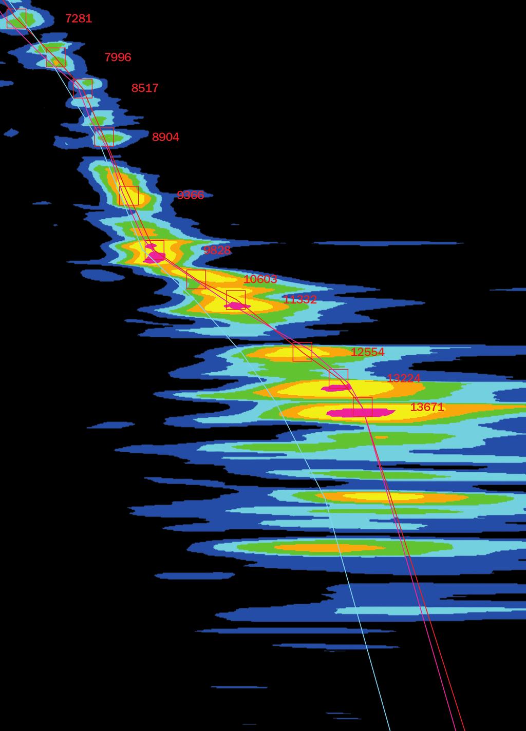
5 SAMPLE OF SERVICES OFFERED 2D/3D land and marine Interactive AVO analysis tools Pre-stack and post-stack inversion Wave equation and Kirchoff (curved ray) pre-stack time and depth migration Multi-component shear and converted wave algorithms (3 to 9C) Multiple attenuation with Radon, tau-p, wave equation, and FK processes Linear noise attenuation algorithms that preserve relative amplitudes A maximum power surface consistent residual statics routine and complete refraction statics analysis tools GRVA/4th Pick is our continuous velocity analysis suite. It performs a velocity analysis on every bin at every sample within a 3D set. The suite uses a 4th order and ETA correction to achieve very flat gathers.
6 E x p e r i e n c e GeoCenter has extensive experience worldwide with a variety of seismic data. GeoCenter is well suited to handle older data sets with both stratigraphic, complex geology, and thrive on new data challenges. Our experience with field data formats has lead us to identify and extract a set of XY coordinates from headers of a SEGD OBC data set to help validate navigation data and interpolate missing coordinates. P A G E S 4 5


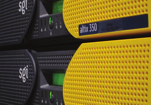
7 C E N T E R C A PAC I T Y GeoCenter utilizes a state-of-the-art data center to meet our processing and development needs. The data center is at the core of our facility featuring a scalable architecture. The design can meet changing needs and expand with the company by exploiting the integrating power, cooling, rack, and management infrastructure. This approach provides increased availability, improved adaptability, speed of deployment, and produces high availability through redundancy. The design also reduces risk of failure, human error, and lowers mean-time-to-repair. Finally, the center structure and design creates a high level of security and reliability for all processing and development projects. GeoCenter s data center features a fully scalable architecture that improves our adaptability, increased availability, speed of deployment, and produces high availability through redundancy.


8 T e c h n o l o g y GeoCenter began as a seismic data processing center, but it soon became evident that custom processing software would have major benefits not only to the company but also to our clients. In this spirit, SeisUP was created. The processing staff and SeisUP developers interact seamlessly together, and because of this close interaction, real world processing and client needs drive software development and ensure that software tools keep pace with processing requirements. The close relationship between processors and SeisUP developers is a major benefit to both service and technology providing flexibility to SeisUP was developed as a 3D interactive processing environment. Processing flows are built through an interactive graphical user interface. Data is QC d interactively even as a job is executing. Rapid interaction increases data throughput. A processor can quickly investigate problems relating to any aspect of a data set. our processing system. The relationship between processors and SeisUP developers is a major benefit in both service and technology. Adjustments and enhancements to the software can be implemented quickly. The processor and clients have ready access to the latest tools and algorithms developed for SeisUP. SeisUP flexibility: If a module does not exist for a defined process, it can be constructed from other existing modules. An example is the implementation of a procedure to compute converted wave refraction statics using interactive stacking of refraction arrivals. P A G E S 6 7
9


10 S e i s U P & S o f t w a r e D e v e l o p m e n t I N T R O D U C T I O N T O S e i s U P In 1986, GeoCenter began development of the SeisUP seismic data processing suite. The first license was issued in To date, GeoCenter has issued more than 200 licenses at centers around the world. SeisUP was designed from the ground up as a 3D processing suite as opposed to a 2D system that was modified for 3D applications. The suite includes processing SeisUP was designed from the ground up as a 3D processing suite as opposed to a 2D system that was modified for 3D applications. SeisUP includes processing applications for 2D, 3D, time, and depth imaging. The extensive suite of more than 305 modules will empower the experienced processor while the intuitive graphic user interface enables novices to be productive within hours. applications for 2D, 3D, time, and depth imaging. A complete list of modules can be found in the accompanying SeisUP literature or on our website. P A G E S 8 9


11 U S E R I N T E R FAC E SeisUP utilizes a graphical interface featuring a workspace containing a set of user specified flows. Data sets and processing modules are linked together with pipes on the canvas. Modules can be inserted from a module library or copied from existing flows and parameters are defined through pull down menus accessed through the module icons. Spreadsheet type parameters, such as velocity functions and mutes, are stored in a database and are available to any module within a project. Job execution is controlled via a job server that accepts job submission from any SeisUP platform on the network. Utility applications such as the Job Monitor, Data Manager and History Viewer show active job status, data set and storage management and information about previous job executions. I N P U T/O U T P U T SeisUP can import all standard seismic field data formats and most variations. Standard field header data, such as geometry, are routinely extracted and stored in processing trace headers and the database as needed. Additional header words may be extracted and mapped to processing trace headers. SEGY format may be imported and exported with complete header word mapping flexibility.

12 D A T A P R E P A R A T I O N Data preparation includes geometry assignment and validation as well as trace editing and polarity correction, all accomplished via interactive displays. Geometry information may be captured from trace headers or entered through a spreadsheet style interface. Coordinate data is easily entered through a Matrix Editor or imported from ASCII files such as SEGP1 and SPS format files. There is an extensive library of tools to manipulate trace header attributes when necessary. D E V E L O P E R T O O L K I T Because of the modular structure of SeisUP, functionality is easily added by the experienced programmer as a que module. API s and documentation are provided for modules written in FORTRAN 77, C, or C. Trace data are passed to a module in a buffer, one ensemble at a time along with pertinent data describing the traces. S e i s U P F I E L D P R O F E S S I O N A L SeisUP Field Professional is built upon the same SeisUP core, but with fewer modules included, allowing field acquisition crews to process seismic data through the brute stack stage. This added capability will offer superior quality assurance as well as increased productivity from your acquisition crew. P A G E S 10 11
13


14 Contact Information We s t w a y P a r k B l vd H o u s t o n, Te x a s Phone: Fax: w w w. g e o c e n t e r. c o m PA G E S 12 SeisUP is a registered trademark of GeoCenter LP.
15
16 4805 Westway Park Blvd. Houston, Texas 77041
The Omega Seismic Processing System. Seismic analysis at your fingertips
 The Omega Seismic Processing System Seismic analysis at your fingertips Omega is a flexible, scalable system that allows for processing and imaging on a single workstation up to massive compute clusters,
Seismic Time Processing. The Basis for Modern Seismic Exploration
 The Future of E&P Seismic Time Processing The Basis for Modern Seismic Exploration Fusion is a leading provider of Seismic Processing for the oil and gas industry from field tapes through final migration.
VISTA. Desktop seismic data processing software
 VISTA Desktop seismic data processing software VERSION 2017 VISTA desktop seismic data processing software VISTA Desktop seismic data processing software Comprehensive seismic processing and QC software
RadExPro seismic software for 2D/3D data QC and infield processing
 RadExPro seismic software for 2D/3D data QC and infield processing History The software took its origin in 1992 at the Geophysical Department, Faculty of Geology, Lomonosov Moscow State University and,
PGS hyperbeam - rapid scenario-testing of velocity models to optimize depth imaging
 A Publication of Petroleum Geo-Services Vol. 10 No. 4 April 2010 PGS hyperbeam - rapid scenario-testing of velocity models to optimize depth imaging Introduction Depth imaging is now established as a key
DUG HAS EXTENSIVE EXPERIENCE WITH COMPLEX DEPTH IMAGING PROJECTS FROM ALL MAJOR OIL AND GAS PRECINCTS
 DEPTH IMAGING DUG HAS EXTENSIVE EXPERIENCE WITH COMPLEX DEPTH IMAGING PROJECTS FROM ALL MAJOR OIL AND GAS PRECINCTS This combined experience, along with our advanced toolkit, means that we are ready and
Reflection Seismic Processing
 Reflection Seismic Processing Objective Processing Systems General concept of CMP processing Processing Tools SEGY and similar file formats General features of ProMAX Reading: ProMAX manual (Introduction)
Multiple suppression with land data: A case study
 Multiple suppression with land data: A case study Gabriel Alvarez 1 ABSTRACT Some of the most important methods for multiple suppression are based on the moveout difference between the hyperbolas corresponding
MiVu. Microseismic Processing System SURVEY DESIGN SIGNAL PROCESSING EVENT LOCATION VISUALIZATION.
 MiVu Microseismic Processing System SURVEY DESIGN SIGNAL PROCESSING EVENT LOCATION VISUALIZATION MiVuTM Microseismic Processing System MiVuTM is a software package designed to perform microseismic monitoring
GeOlympus. GeoPACS GeoTR GeoStaR GeoWZ
 GeOlympus GeoPACS GeoTR GeoStaR GeoWZ GeOlympus Workstation Work station Reflection time Refracted waves first arrivals Additional information Static and NMO corrections Layer by layer delay and statics
RadExPro release notes
 1 RadExPro 2017.3 release notes We are excited to tell you that RadExPro 2017.3 is ready now. There is a lot of useful new features in this release: Brand-new Acoustic Inversion module implements a genetic
Borehole Seismic Services Data processing, imaging and dedicated expertise
 Borehole Seismic Services Data processing, imaging and dedicated expertise To reduce risk and optimize recovery, you need a clear picture of the reservoir. OptaSense Borehole Seismic Services help you
Practical implementation of SRME for land multiple attenuation
 Practical implementation of SRME for land multiple attenuation Juefu Wang* and Shaowu Wang, CGGVeritas, Calgary, Canada juefu.wang@cggveritas.com Summary We present a practical implementation of Surface
GeoDepth. Velocity Determination, Modeling and Imaging
 1 GeoDepth Velocity Determination, Modeling and Imaging 1 GeoDepth An Integrated System for Highest Quality Imaging in Depth Depth image with salt domes A Comprehensive System for Improved Seismic Imaging
Residual Moveout Analysis in a 3D dataset from Amplitude Variations with Offfset
 P-270 Residual Moveout Analysis in a 3D dataset from Amplitude Variations with Offfset Summary Subhendu Dutta, ONGC The amplitude variations with offset (AVO) is a very useful tool which compliments the
Seismic Data Preconditioning for Improved Reservoir Characterization (Inversion and Fracture Analysis)
") Seismic Data Preconditioning for Improved Reservoir Characterization (Inversion and Fracture Analysis) Darren Schmidt *, Hampson-Russell, Calgary, AB, Canada Darren.Schmidt@cggveritas.com Alicia Veronesi,
Seismic Data Preconditioning for Improved Reservoir Characterization (Inversion and Fracture Analysis) Darren Schmidt *, Hampson-Russell, Calgary, AB, Canada Darren.Schmidt@cggveritas.com Alicia Veronesi,
Planning Land 3-D Seismic Surveys
 Planning Land 3-D Seismic Surveys Andreas Cordsen, Mike Galbraith, and John Peirce Edited by Bob A. Hardage Series Editor: Stephen J. Hill Geophysical Developments Series No. 9 Society of Exploration Geophysicists
Extension of delay time analysis for 3-D seismic refraction statics
 Extension of delay time analysis for 3-D Extension of delay time analysis for 3-D seismic refraction statics Jocelyn Dufour and Don C. Lawton ABSTRACT This current research is on the extension of delay
A Short Narrative on the Scope of Work Involved in Data Conditioning and Seismic Reservoir Characterization
 A Short Narrative on the Scope of Work Involved in Data Conditioning and Seismic Reservoir Characterization March 18, 1999 M. Turhan (Tury) Taner, Ph.D. Chief Geophysicist Rock Solid Images 2600 South
Seismic Reflection Method
 Seismic Reflection Method 1/GPH221L9 I. Introduction and General considerations Seismic reflection is the most widely used geophysical technique. It can be used to derive important details about the geometry
Challenges of pre-salt imaging in Brazil s Santos Basin: A case study on a variable-depth streamer data set Summary
 Challenges of pre-salt imaging in Brazil s Santos Basin: A case study on a variable-depth streamer data set Jeremy Langlois, Bing Bai, and Yan Huang (CGGVeritas) Summary Recent offshore discoveries in
G009 Multi-dimensional Coherency Driven Denoising of Irregular Data
 G009 Multi-dimensional Coherency Driven Denoising of Irregular Data G. Poole* (CGGVeritas Services (UK) Ltd) SUMMARY Many land and ocean bottom datasets suffer from high levels of noise which make the
A stochastic approach of Residual Move Out Analysis in seismic data processing
 A stochastic approach of Residual ove Out Analysis in seismic data processing JOHNG-AY T.,, BORDES L., DOSSOU-GBÉTÉ S. and LANDA E. Laboratoire de athématique et leurs Applications PAU Applied Geophysical
Selection of an optimised multiple attenuation scheme for a west coast of India data set
 P-391 Selection of an optimised multiple attenuation scheme for a west coast of India data set Summary R Pathak*, PC Kalita, CPS Rana, Dr. S. Viswanathan, ONGC In recent years a number of new algorithms
Geogiga Seismic Pro 9.0 Release Notes
 Geogiga Seismic Pro 9.0 Release Notes Copyright 2018, All rights reserved. Table of Contents Introduction...1 Part 1 New Modules...3 Modeling2D...3 Surface RT...4 Part 2 General Enhancements...5 Part 3
P071 Land Data Regularization and Interpolation Using Azimuth Moveout (AMO)
") P071 Land Data Regularization and Interpolation Using Azimuth Moveout (AMO) A.M. Popovici* (3DGeo Development Inc.), S. Crawley (3DGeo), D. Bevc (3DGeo) & D. Negut (Arcis Processing) SUMMARY Azimuth Moveout
P071 Land Data Regularization and Interpolation Using Azimuth Moveout (AMO) A.M. Popovici* (3DGeo Development Inc.), S. Crawley (3DGeo), D. Bevc (3DGeo) & D. Negut (Arcis Processing) SUMMARY Azimuth Moveout
By Tracy J. Stark 1. Search and Discovery Article #40133 (2004) Introduction
 Introduction") GC Value in Visualization* By Tracy J. Stark 1 Search and Discovery Article #40133 (2004) *Adapted from the Geophysical Corner column in AAPG Explorer, June, 2004, entitled Why Do We Need to Have Visualization?
GC Value in Visualization* By Tracy J. Stark 1 Search and Discovery Article #40133 (2004) *Adapted from the Geophysical Corner column in AAPG Explorer, June, 2004, entitled Why Do We Need to Have Visualization?
SeisSpace Software. SeisSpace enables the processor to be able focus on the science instead of being a glorified data manager.
 SeisSpace Software OVERVIEW Delivering large volumes of data quickly and accurately remains the hallmark of any seismic processing system. With intuitive analysis tools, state-of-the-art geophysical algorithms
We LHR5 06 Multi-dimensional Seismic Data Decomposition for Improved Diffraction Imaging and High Resolution Interpretation
 We LHR5 06 Multi-dimensional Seismic Data Decomposition for Improved Diffraction Imaging and High Resolution Interpretation G. Yelin (Paradigm), B. de Ribet* (Paradigm), Y. Serfaty (Paradigm) & D. Chase
NORSAR-3D. Predict and Understand Seismic. Exploring the Earth. Find the answers with NORSAR-3D seismic ray-modelling
 Exploring the Earth NORSAR-3D Predict and Understand Seismic Is undershooting possible? Which is the best survey geometry? MAZ, WAZ, RAZ, Coil, OBS? Why are there shadow zones? Can they be illuminated?
EarthStudy 360. Full-Azimuth Angle Domain Imaging and Analysis
 EarthStudy 360 Full-Azimuth Angle Domain Imaging and Analysis 1 EarthStudy 360 A New World of Information for Geoscientists Expanding the Frontiers of Subsurface Exploration Paradigm EarthStudy 360 is
Seismic data Interpolation in the Continuous Wavenumber Domain, Flexibility and Accuracy
 Seismic data Interpolation in the Continuous Wavenumber Domain, Flexibility and Accuracy Ye Zheng Geo-X Exploration Services Inc. Summary Our recently developed algorithm, ASFT (Arbitrarily Sampled Fourier
Introduction. Surface and Interbed Multtple Elimination
 Pre-stack Land Surface and Interbed Demultiple Methodology An Example from the Arabian Peninsula Roald van Borselen, Grog Fookes, Michel Schonewille, Constantine Tsingas, Michael West PGS Geophysical;
Zero offset VSP processing for coal reflections
 Zero offset VSP processing for coal reflections Salman K. Bubshait and Don C. Lawton ABSTRACT Shlumberger has acquired five VSP surveys on behalf of EnCana in Alberta. The primary goal of the VSP surveys
Azimuth Moveout (AMO) for data regularization and interpolation. Application to shallow resource plays in Western Canada
 for data regularization and interpolation. Application to shallow resource plays in Western Canada") Azimuth Moveout (AMO) for data regularization and interpolation. Application to shallow resource plays in Western Canada Dan Negut, Samo Cilensek, Arcis Processing, Alexander M. Popovici, Sean Crawley,
Azimuth Moveout (AMO) for data regularization and interpolation. Application to shallow resource plays in Western Canada Dan Negut, Samo Cilensek, Arcis Processing, Alexander M. Popovici, Sean Crawley,
Wave-equation migration from topography: Imaging Husky
 Stanford Exploration Project, Report 123, October 31, 2005, pages 49 56 Short Note Wave-equation migration from topography: Imaging Husky Jeff Shragge 1 INTRODUCTION Imaging land seismic data is wrought
Angle Gathers for Gaussian Beam Depth Migration
 Angle Gathers for Gaussian Beam Depth Migration Samuel Gray* Veritas DGC Inc, Calgary, Alberta, Canada Sam Gray@veritasdgc.com Abstract Summary Migrated common-image-gathers (CIG s) are of central importance
Examples of GLOBE Claritas Processing
 V6.0 Examples of GLOBE Claritas Processing Refraction Statics Removal of Noise (Land, 3D) Removal of Swell Noise Interpolation : shots/receivers Interpolation : 5D (STITCH) Demultiple : High Resolution
HPC Solutions in High Density Data Centers
 Executive Report HPC Solutions in High Density Data Centers How CyrusOne s Houston West data center campus delivers the highest density solutions to customers With the ever-increasing demand on IT resources,
Three critical concerns for marine seismics with portable systems. Source strength and tuning Streamer length 2D vs. 3D
 Three critical concerns for marine seismics with portable systems Source strength and tuning Streamer length 2D vs. 3D Airgun Source Single airgun Multiple airguns signal strength volume 1/3 1 x (200 in
Plus-Minus Method of Refraction Seismic Data Analysis in RadExPro Software
 Plus-Minus Method of Refraction Seismic Data Analysis in RadExPro Software (Revision of 28.11.2016) DECO Geophysical SC Moscow State University Science Park 1-77 Leninskie Gory Moscow 119992, Russia Tel.:
INGRAM MICRO & DELL. Partner Kit
 Partner Kit Partner Kit Welcome... Ingram Micro Dell Advantage Enterprise Range........................... Partner Support... Ingram Micro Key Contacts... Resources... 3 4 6 7 8 Partner Kit 2 Welcome to
ADVANTAGES AND DISADVANTAGES OF SURFACE AND DOWNHOLE SEISMIC ILLUSTRATED BY PROCESSING RESULTS OF 3D VSP AND 3D+VSP
 P3 ADVANTAGES AND DISADVANTAGES OF SURFACE AND DOWNHOLE SEISMIC ILLUSTRATED BY PROCESSING RESULTS OF 3D VSP AND 3D+VSP A.A. Tabakov* & K.V. Baranov** (* CGE JSC, Moscow, ** GEOVERS Ltd., Moscow) Abstract.
3-D vertical cable processing using EOM
 Carlos Rodriguez-Suarez, John C. Bancroft, Yong Xu and Robert R. Stewart ABSTRACT Three-dimensional seismic data using vertical cables was modeled and processed using equivalent offset migration (EOM),
The power of stacking, Fresnel zones, and prestack migration
 The power of stacking, Fresnel zones, and prestack migration John C. Bancroft and Shuang Sun ABSTRACT The stacking of common midpoint (CMP) gathers assumes the presence of specula reflection energy and
1.5D internal multiple prediction on physical modeling data
 1.5D internal multiple prediction on physical modeling data Pan Pan*, Kris Innanen and Joe Wong CREWES, University of Calgary Summary Multiple attenuation is a key aspect of seismic data processing, with
Processing converted-wave data in the tau-p domain: rotation toward the source and moveout correction
 τ-p domain converted-wave processing Processing converted-wave data in the tau-p domain: rotation toward the source and moveout correction Raul Cova and Kris Innanen ABSTRACT The asymmetry of the converted-wave
IBM WebSphere Message Broker for z/os V6.1 delivers the enterprise service bus built for connectivity and transformation
 IBM Europe Announcement ZP07-0445, dated October 9, 2007 IBM WebSphere Message Broker for z/os V6.1 delivers the enterprise service bus built for connectivity and transformation Description...2 Product
P312 Advantages and Disadvantages of Surface and Downhole Seismic Illustrated by Processing Results of 3D VSP and 3D+VSP
 P312 Advantages and Disadvantages of Surface and Downhole Seismic Illustrated by Processing Results of 3D VSP and 3D+VSP A.A. Tabakov* (Central Geophysical Expedition (CGE) JSC) & K.V. Baranov (Geovers
GeoProbe Geophysical Interpretation Software
 DATA SHEET GeoProbe Geophysical Interpretation Software overview DecisionSpace Geosciences key features Integrated building, editing and interactive deformation of sealed multi-z bodies extracted from
1D internal multiple prediction in a multidimensional world: errors and recommendations
 1D internal multiple prediction 1D internal multiple prediction in a multidimensional world: errors and recommendations Pan Pan and Kris Innanen ABSTRACT Internal multiples are more difficult to estimate
SeisEarth. Multi-survey Regional to Prospect Interpretation
 SeisEarth Multi-survey Regional to Prospect Interpretation 1 SeisEarth Fast and accurate interpretation, from regional to reservoir We ve been experimenting with the newest version of SeisEarth for some
Land Imaging with FireFly
 Land Imaging with FireFly Presented at the Lehman Brothers Investor Day By Jim Hollis (Executive VP and COO, ION Solutions) December 6, 2007 Houston, Texas USA Getting Grounded: The Seismic Imaging Market
CLASSIFICATION OF MULTIPLES
 Introduction Subsurface images provided by the seismic reflection method are the single most important tool used in oil and gas exploration. Almost exclusively, our conceptual model of the seismic reflection
Pre-stack Merging of 3D Vintages : A case History from Assam Arakan Fold Belt
 P-195 Apurba K. Basak*, Pulak K. Bera and Murali Mohan, ONGC Summary Pre-stack merging of 10 vintages of overlapping 3D seismic data of 632 sq. km acquired in several field seasons using different equipment
Maximizing the value of the existing seismic data in Awali field Bahrain, by utilizing advanced 3D processing technology.
 Maximizing the value of the existing seismic data in Awali field Bahrain, by utilizing advanced 3D processing technology. Eduard Maili* (OXY - Tatweer), Scott Burns (OXY), Neil Jones (Consultant, OXY)
Coherent partial stacking by offset continuation of 2-D prestack data
 Stanford Exploration Project, Report 82, May 11, 2001, pages 1 124 Coherent partial stacking by offset continuation of 2-D prestack data Nizar Chemingui and Biondo Biondi 1 ABSTRACT Previously, we introduced
P. Bilsby (WesternGeco), D.F. Halliday* (Schlumberger Cambridge Research) & L.R. West (WesternGeco)
, D.F. Halliday* (Schlumberger Cambridge Research) & L.R. West (WesternGeco)") I040 Case Study - Residual Scattered Noise Attenuation for 3D Land Seismic Data P. Bilsby (WesternGeco), D.F. Halliday* (Schlumberger Cambridge Research) & L.R. West (WesternGeco) SUMMARY We show that
I040 Case Study - Residual Scattered Noise Attenuation for 3D Land Seismic Data P. Bilsby (WesternGeco), D.F. Halliday* (Schlumberger Cambridge Research) & L.R. West (WesternGeco) SUMMARY We show that
RELEASING LATENT VALUE DOCUMENT: CA NETMASTER NETWORK MANAGEMENT R11.5. Releasing the Latent Value of CA NetMaster Network Management r11.
 RELEASING LATENT VALUE DOCUMENT: CA NETMASTER NETWORK MANAGEMENT R11.5 Releasing the Latent Value of CA NetMaster Network Management r11.5 Table of Contents Product Situation Analysis Analysis of Problems
L 5 Seismic Method. Courtesy of ExxonMobil. Mitchum et al., 1977b
 Courtesy of ExxonMobil L 5 Seismic Method AAPG 1977 reprinted with permission of the AAPG whose permission is required for further use. Mitchum et al., 1977b Basic Exploration Workflow Identify Opportunities
Seismic Imaging: Prestack
 Seismic Imaging: Prestack John C. Bancroft DEPARTMENT OF GEOLOGY & GEOPHYSICS, UNIVERSITY OF CALGARY, CALGARY, ALBERTA CSEG RECORDER NOV 2002 VOL. 26 NO. 09 Article Bios References Print Abstract The kinematics
AVS as a 3-D seismic data visualizing platform
 Stanford Exploration Project, Report 82, May 11, 2001, pages 1 104 AVS as a 3-D seismic data visualizing platform Robert G. Clapp, Biondo Biondi, and Martin Karrenbach 1 ABSTRACT In an effort to increase
Comparison of Kirchhoff and Wave Equation PSDM : A Case Study from West Patan Area
 P-352 : A Case Study from West Patan Area B. K. Medhi*, C. B. Yadava, Kuldeep Prakash, Kunal Niyogi, S. K. Das GEOPIC, Oil & Natural Gas Corporation Ltd, Dehradun Summary West Patan area of north Cambay
Minimizing Fracture Characterization Uncertainties Using Full Azimuth Imaging in Local Angle Domain
 P-237 Minimizing Fracture Characterization Uncertainties Using Full Azimuth Imaging in Local Angle Domain Shiv Pujan Singh*, Duane Dopkin, Paradigm Geophysical Summary Shale plays are naturally heterogeneous
Why do we need Visualization? By Tracy J. Stark STARK Research
 Why do we need Visualization? By Tracy J. Stark STARK Research tstark3@attglobal.net How do you convince a non believer, in a short article with only a few static figures, the need for visualization? Within
High-resolution Moveout Transform; a robust technique for modeling stackable seismic events Hassan Masoomzadeh* and Anthony Hardwick, TGS
 High-resolution Moveout Transform; a robust technique for modeling stackable seismic events Hassan Masoomzadeh* and Anthony Hardwick, TGS Summary We propose a time-domain approach to transform a gather
Review of seismic imaging: Prestack
 Review of seismic imaging: Prestack John C. Bancroft Published in the CSEG Recorder - November 001 Review of seismic migration: Prestack ABSTRACT The kinematics of prestack data considers an arbitrary
This course provides introductory knowledge of the land survey systems used in the United States - Congressional/Jeffersonian, Metes and Bounds,
 PDM-001 Introduction to High quality, trusted and accessible data and information is essential to the oil and gas industry. As the professional society for data managers, the plays a key role in meeting
HIGH RESOLUTION STACKING OF SEISMIC DATA. Marcos Ricardo Covre, Tiago Barros and Renato da Rocha Lopes
 HIGH RESOLUTION STACKING OF SEISMIC DATA Marcos Ricardo Covre, Tiago Barros and Renato da Rocha Lopes School of Electrical and Computer Engineering, University of Campinas DSPCom Laboratory, Department
Get more out of technology starting day one. ProDeploy Enterprise Suite
 Enterprise Suite Get more out of technology starting day one 1 Secure the path to a future-ready data center The landscape faced by IT managers and business leaders today can be daunting to navigate. Continually
Geology 554 Environmental and Exploration Geophysics II Final Exam
 Geology 554 Environmental and Exploration Geophysics II Final Exam In this exam, you are asked to apply some of the seismic interpretation skills you ve learned during the semester to the analysis of another
Missing trace interpolation and its enhancement of seismic processes
 Missing trace interpolation Missing trace interpolation and its enhancement of seismic processes Wai-kin Chan and Robert R. Stewart ABSTRACT Many multi-channel seismic algorithms assume that the input
RadExPro release notes
 RadExPro 2012.3 release notes We are happy to let you know that the next version of our seismic software, RadExPro 2012.3, is ready now for release. We have added a new trace header field, SOU_IND, for
It is widely considered that, in regions with significant
 Multifocusing-based multiple attenuation Alex Berkovitch and Kostya Deev, Geomage Evgeny Landa, OPERA It is widely considered that, in regions with significant geologic complexity, methods which work directly
G012 Scattered Ground-roll Attenuation for 2D Land Data Using Seismic Interferometry
 G012 Scattered Ground-roll Attenuation for 2D Land Data Using Seismic Interferometry D.F. Halliday* (Schlumberger Cambridge Research), P.J. Bilsby (WesternGeco), J. Quigley (WesternGeco) & E. Kragh (Schlumberger
Using GLOBE Claritas. 2D/3D Seismic Processing Software
 Using GLOBE Claritas 2D/3D Seismic Processing Software June 2008 GLOBE Claritas : Concept Created as a processing environment Designed to fit around your workflows and practices No un-wieldy database or
CREWES computer systems
 CREWES computer systems CREWES computer systems Rolf Maier, Kevin Hall and Henry Bland ABSTRACT Much of the research performed at CREWES is centred on numerical geophysics. Computers and the software packages
What s New and Where to Find It in V6.8
 What s New and Where to Find It in V6.8 Q4 2017 V6.8 At A Glance (Jan 2018) New SPSTAT2 module is simpler & easier to use, no specialized sort required, has inbuilt AGC and noise attenuation capability.
Geogiga Seismic Pro 8.0 Release Notes
 Geogiga Seismic Pro 8.0 Release Notes Copyright 2015, All rights reserved. Table of Contents Introduction...1 Part 1 General Enhancements...3 Trace Display...4 Color Section Display...6 Curve Plotting...8
Geogiga Seismic Pro 8.3 Release Notes
 Geogiga Seismic Pro 8.3 Release Notes Copyright 2017, All rights reserved. Table of Contents Introduction...1 Part 1 Utility Modules...2 Part 2 Reflection Modules...4 Updates in SF Imager...5 Updates in
Summary. Introduction
 Application of Surface-wave modeling and inversion in Cordova Embayment of northeastern British Columbia Antoun Salama*, Schlumberger-WesternGeco, Houston, Texas, USA ASalama@slb.com and Niranjan Banik,
Smart Data Center Solutions
 Smart Data Center Solutions New Data Center Challenges Require New Solutions Data Center Architecture. Inside and Out. Data centers are mission-critical facilities. A silo-based approach to designing,
IPTC Title: High Resolution, Simultaneous VSP and Land Seismic Acquisition. Scott Robinson, Qatar Petroleum
 Title: High Resolution, Simultaneous VSP and Land Seismic Acquisition Authors Scott Robinson, Qatar Petroleum primary author o P. O. Box 47, Doha, Qatar; (+974) 440-1465; s_robinson@qp.com.qa Salva R Seeni,
y Input k y2 k y1 Introduction
 A regularization workflow for the processing of cross-spread COV data Gordon Poole 1, Philippe Herrmann 1, Erika Angerer 2, and Stephane Perrier 1 1 : CGG-Veritas, 2 : OMV Data regularization is critical
P068 Case Study 4D Processing OBC versus Streamer Example of OFON filed, Block OML102, Nigeria
 P068 Case Study 4D Processing OBC versus Streamer Example of OFON filed, Block OML102, Nigeria T. Castex* (Total SA), P. Charrier (CGG), M.N. Dufrene (Total SA) & C. Orji (EPNL) SUMMARY This case study
A simulated Simultaneous Source Experiment in Shallow waters and the Impact of Randomization Schemes Rolf Baardman, Roald van Borselen, PGS
 simulated Simultaneous Source Experiment in Shallow waters and the Impact of Randomization Schemes Rolf aardman, Roald van orselen, PGS Summary In simultaneous source acquisition, seismic data can be recorded
PRODUCT HIGHLIGHTS. Velocity Modeling - Time/Depth Conversion A COMPLETE SEISMIC INTERPRETATION SOLUTION
 PRODUCT HIGHLIGHTS Velocity Modeling - Time/Depth Conversion Easily create reliable velocity models and depth convert seismic volumes and interpretation. Create multi-layer horizon top equivalences to
Veritas Hampson-Russell Software Release CE7 / R1. November 15, Release Notes
 Veritas Hampson-Russell Software Release CE7 / R1 November 15, 2004 Release Notes Product Name Main Programs Supplied and Version Numbers AFI afi (2.0) embedding avo (6.0) AVO avo (6.0) geoview (4.0) elog
Considerations in 3D depth-specific P-S survey design
 Considerations in 3D depth-specific P-S survey design Don C. Lawton and Peter W. Cary 3D P-S survey design ABSTRACT A new sparse-shot design for 3D P-S surveys is introduced. In the sparse shot design
Is the optimum XY spacing of the Generalized Reciprocal Method (GRM) constant or variable?
 constant or variable?") Is the optimum XY spacing of the Generalized Reciprocal Method (GRM) constant or variable? Abstract The Generalized Reciprocal Method (GRM) is suggested to be used for mapping subsurface structures with
Is the optimum XY spacing of the Generalized Reciprocal Method (GRM) constant or variable? Abstract The Generalized Reciprocal Method (GRM) is suggested to be used for mapping subsurface structures with
Agilent E7478A GPRS Drive Test System
 Agilent E7478A GPRS Drive Test System Product Overview Quickly deploy your GPRS networks and manage multiformat environments Our drive test solution doesn t just uncover problems on your GPRS network it
Assessing the Value of an Integrated GIS Seismic Management System
 March 8, 2005 Author: Scott McCulloch Assessing the Value of an Integrated GIS Seismic Management System TGS-NOPEC Geophysical Company Abstract TGS seismic order entry system is an enterprise-level database
Advances in radial trace domain coherent noise attenuation
 Advances in radial trace domain coherent noise attenuation ABSTRACT David C. Henley* CREWES, Department of Geology and Geophysics University of Calgary, Calgary, AB henley@crewes.org The radial trace transform,
Flexi Binning : A Solution for Irregular Acquisition Geometry
 5th Conference & Exposition on Petroleum Geophysics, Hyderabad-2004, India PP 199-203 Flexi Binning : A Solution for Irregular Acquisition Geometry M. S. Rawat 1, M. Goswamy 1 & M. Das 2 1 GEOPIC, ONGC,
MAPPING POISSON S RATIO OF UNCONSOLIDATED MATERIALS FROM A JOINT ANALYSIS OF SURFACE-WAVE AND REFRACTION EVENTS INTRODUCTION
 MAPPING POISSON S RATIO OF UNCONSOLIDATED MATERIALS FROM A JOINT ANALYSIS OF SURFACE-WAVE AND REFRACTION EVENTS Julian Ivanov, Choon B. Park, Richard D. Miller, and Jianghai Xia Kansas Geological Survey
Refractor 8.1 User Guide
 Refractor 8.1 User Guide Copyright 2016, All rights reserved. Table of Contents Preface...1 Conventions Used in This Guide...1 Where to Find Information...1 Technical Support...2 Feedback...2 Chapter 1
Chapter N/A: The Earthquake Cycle and Earthquake Size
 This sheet provides a general outline of the topics covered on your upcoming exam. This is not an exhaustive list, but is simply a general list of key points. In other words, most exam questions will be
Headwave Stacking in Terms of Partial Derivative Wavefield
 Geosystem Engineering, 7(1), 21-26 (March 2004) Headwave Stacking in Terms of Partial Derivative Wavefield Changsoo Shin School of Civil, Urban and Geosystem Engineering, Seoul National University, San
ProDeploy Suite. Accelerate enterprise technology adoption with expert deployment designed for you
 Accelerate enterprise technology adoption with expert deployment designed for you 1 Shift resources to innovate and drive better business outcomes The landscape faced by IT managers and business leaders
Seamless Pre-Stack Integration of Streamer Datasets with Q-Marine Dataset A Case Study from Eastern Coast of India
 P-247 Summary: Seamless Pre-Stack Integration of Streamer Datasets with Q-Marine Dataset A Case Study from Eastern Coast of India V P Singh*, D K Vishnoi, S Basu, Mrs S Mohapatra, Rajeev Mohan, A C Mandal