TACCIMO A CASE STUDY OF MIGRATING TO THE ARCGIS SERVER API FOR FLEX
|
|
|
- Gervase Stevenson
- 5 years ago
- Views:
Transcription


1 TACCIMO A CASE STUDY OF MIGRATING TO THE ARCGIS SERVER API FOR FLEX Todd Pierce, Jeff Hicks, Amber Ramirez, Caroline Dougherty UNC Asheville s National Environmental Modeling and Analysis Center Jennifer Moore Myers, Rob Herring, Emrys Treasure, Steve McNulty, and Chris Liggett USDA Forest Service, Eastern Forest Environmental Threat Assessment Center 2011 ESRI SERUG
2 Overview Purpose of presentation: v Describe TACCIMO product v Explain migration to Flex environment v Provide lessons learned
3 Project History TACCIMO (Template for Assessing Climate Change Impacts and Management Options) v helps users integrate climate change science into land management planning v provides land and resource managers and planners with the best available science they need to effectively and efficiently sustain forests and the services they provide under a changing climate.
4 Initial version released in 2010 as a web-based assessment and reporting tool included: v Geospatial explorer shows climate data maps v Geospatial report provides climate model projections for national forests through 2090 v Content explorer displays climate change impacts on forests, along with management options, objectives, and design criteria for creating forest response plans v Report wizard generates custom reports that provide climate change specific impacts and management options Project History TACCIMO was developed through a partnership between the USDA Forest Service s Southern Research Station and Southern Region Planning divisions.

5 Initial Version Geospatial Explorer: initial version used out-of-the-box ArcGIS Server web application; data in ESRI geodatabases


6 Initial Version Content Explorer and Report Wizard: HTML and ASP.NET Geospatial Report: manually generated reports in MS Word
7 Initial Version The initial version was successful, but the TACCIMO development team wanted to bring the various components together into one single web application. The team also wanted to have a richer web interface using the Adobe Flex/Flash platform. UNC Asheville s NEMAC was brought in to migrate TACCIMO to the new platform and to combine the components into one application (the integrator ).

8 Flex Migration New version combines previous components into one interface. Demonstration v GIS data in ESRI geodatabases v Data served with ESRI ArcGIS Server 10.NET v Climate model projection data in SQL Server 2008 database
9 Flex Migration Geospatial explorer included in GIS Viewer window v Flex SDK 3.2 v ESRI ArcGIS Server Flex API 1.3

10 Flex Migration Geospatial explorer supports charts of climate model projections for clicked map points v Flex SDK 3.2 v ESRI ArcGIS Server Flex API 1.3 v PHP v Zend 1.11
11 Flex Migration Climate Chart window shows climate data projections in tables and charts v Flex SDK 3.2 v PHP v Zend 1.11

12 Flex Migration Content Explorer available in Science and Planning pane shows management options for areas v Flex SDK 3.2 v PHP v Zend 1.11

13 Flex Migration Content Explorer available in Science and Planning pane also shows desired conditions, objectives, design criteria for forests v Flex SDK 3.2 v PHP v Zend 1.11

14 Flex Migration Menu box lets user switch between states, counties, regions, and US National Forests v Flex SDK 3.2

15 Flex Migration Geospatial Report now accessible from menu box v Flex SDK 3.2 v PHP v tcpdf 5.9

16 Flex Migration Geospatial Report generated on-the-fly for selected area and exported to PDF v PHP v tcpdf 5.9 v Map images from WMS services in ArcGIS Server
17 Lessons Learned Communicate, communicate, communicate v TACCIMO team in Raleigh, NEMAC in Asheville v NEMAC team Flex beginners; TACCIMO team Flex newcomers v Many phone calls and s v Four team visits over seven month period
18 Lessons Learned Moving from text based code language to compiled language presents some challenges v Flex uses ActionScript and MXML, both compiled into a SWF file for deployment v Code can no longer easily be opened in Notepad and edited on the server environment requires a development environment such as Flex Builder or Flash Builder (Eclipse is open source version) v Had to coordinate versions of Flex SDK (Software Development Kit), ESRI APIs, and Flex Builder

19 FlexBuilder 3 interface Lessons Learned
20 Lessons Learned Connecting Flex to databases requires use of server side language separate from ActionScript and MXML v For a data driven application, the Flash SWF app (client) must make requests to a database (server) v First attempts using ColdFusion worked easily, but USFS needed an open source solution v Final version uses PHP with Zend library to connect PHP to Flex (Zend located at
21 Lessons Learned Connecting Flex to databases requires use of server side language separate from ActionScript and MXML v Zend connection required several steps v Write PHP queries to database as functions v Create a PHP gateway file to load Zend and PHP functions v Edit services-config.xml in Flex to point to gateway file v Add the services XML file into the Flex project compile arguments v Set up Remote Object in Flex to connect to the PHP functions through the gateway file v Write functions to call the Remote Object and to process results returned from PHP
22 Lessons Learned Flex requires a team of programmers with different skills v Previous projects at NEMAC done by one or two persons v TACCIMO required a larger team with multiple skills v One member specialized in the interface colors, styles, graphics, transitions, effects v One member focused on the GIS-Flex interaction using the ESRI API for Flex v One member focused on the database schema and the PHP code needed to query the database v One member focused on the Flex-database interactions and Zend for PHP
23 Lessons Learned Dedicated team programming efforts make a big difference v NEMAC staff usually work on several projects at once v For this project, 2 members were 100% dedicated, and the other 2 members were roughly 75% dedicated v Led to rapid strides in development; initial prototype completed in just a couple months v Final version delivered five months after project start v Such concentration of resources often not possible has not been done again due to competing project deadlines

24 Lessons Learned Large teams need code management software and version control v Subversion plugin (open source) used for Flex v Supports code check in/out and change synchronization v Worked well most of the time as long as team remembered to commit changes, and to get latest changes when opening code v Requires setting up a subversion repository
25 Lessons Learned Use external configuration file(s) to minimize coding changes v Similar to approach used by ESRI s Flex Viewer application v Have XML configuration file store items that end user might want to change, without need for developers to edit code and recompile SWF file v ArcGIS services to load to map v Choices for background map (streets, image, terrain, etc) v Initial extent of map and bookmarks for quick zooming v Hyperlinks to external resources in links bar v Combinations of services into map themes v Settings for map tools (print, find, identify, export, etc)


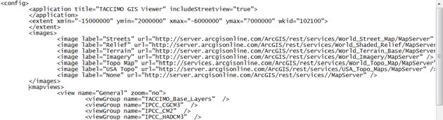
26 Lessons Learned Use external configuration file(s) to minimize coding changes
27 Lessons Learned Use external configuration file(s) to support portability v Similar to approach used by ESRI s Flex Viewer application v Have configuration file store items likely to change as application is moved across servers, or as data changes v Path to ArcGIS Server REST folder (different server names) v Location of needed images v Connection information for SQL server database v Path to export reports and resulting URL


28 Lessons Learned Don t be afraid to hard code things that don t change, if you get faster performance v List of states, counties, forests not expected to change store in code file instead of querying database
 v But, took 735 MB of space just for states, regions, forests counties not done (would add another 9")
29 Lessons Learned Don t be afraid to value speed over disk space v Maps of climate change projections for areas in geospatial report data not expected to change create pre-generated images at needed scale rather than query WMS server on the fly (saved several minutes per report) v But, took 735 MB of space just for states, regions, forests counties not done (would add another 9 GB)
30 v Training on needed skills to keep application running Lessons Learned Transferring working application to another organization requires considerable planning and probably on-site work v Setting up same environment on server (PHP, ArcGIS Server) v Moving spatial and SQL databases v Setting up ArcGIS Services v Finding hard coded paths and URLs and making generic v Handing off needed documentation and metadata

31 Conclusion The TACCIMO product serves as a useful case study of migration to Flex Many lessons learned being applied to other development projects at NEMAC tpierce@unca.edu jmooremyers@fs.fed.us
Working with the ArcGIS Viewer for Flex Application Builder
 Working with the ArcGIS Viewer for Flex Application Builder Esri Canada User Conference St. John s November 15, 2012 Presented By: Greg Yetman gyetman@esri.ca Agenda This seminar is designed to help you
Building Mashups Using the ArcGIS APIs for FLEX and JavaScript. Shannon Brown Lee Bock
 Building Mashups Using the ArcGIS APIs for FLEX and JavaScript Shannon Brown Lee Bock Agenda Introduction Mashups State of the Web Client ArcGIS Javascript API ArcGIS API for FLEX What is a mashup? What
Creating Web Mapping Applications. Nikki Golding
 Creating Web Mapping Applications Nikki Golding Agenda Web Mapping and Map Services Fundamentals ArcGIS Web Mapping Applications - ArcGIS.com Viewer - ArcGIS Explorer Online - ArcGIS Viewer for Flex -
ArcGIS Viewer for Flex Advanced Topics
 Esri International User Conference San Diego, California Technical Workshops July 27, 2012 ArcGIS Viewer for Flex Advanced Topics Lloyd Heberlie Björn Svensson Before we begin Who are we? - Bjorn Svensson
Flex 3 Pre-release Tour
 Flex 3 Pre-release Tour Andrew Shorten shorten@adobe.com Enrique Duvos duvos@adobe.com Flex 3 Pre-release Tour Agenda Adobe Platform Update (45 mins) Flex Builder 3 Features (45 mins) Adobe & Open Source
No Programming Required Create web apps rapidly with Web AppBuilder for ArcGIS
 No Programming Required Create web apps rapidly with Web AppBuilder for ArcGIS By Derek Law, Esri Product Manager, ArcGIS for Server Do you want to build web mapping applications you can run on desktop,
Web Mapping Applications with ArcGIS. Bernie Szukalski Derek Law
 Web Mapping Applications with ArcGIS Bernie Szukalski Derek Law Agenda Web Mapping and Map Services Fundamentals ArcGIS Web Mapping Applications - Hosted online - Hosted on-premise Summary Web Application
What s New in ArcGIS Server 10
 What s New in ArcGIS Server 10 Derek Law ArcGIS Server Product Management What s s new in ArcGIS Server 10? Agenda Highlights: Enhanced Web mapping More powerful server-based analysis Geo-collaboration
ArcGIS Viewer for Flex An Introduction
 2013 Esri International User Conference July 8 12, 2013 San Diego, California Technical Workshop ArcGIS Viewer for Flex An Introduction Bjorn Svensson and Heather Gonzago @Bjorn_Svensson @hgonzago Esri
EUCOM/AFRICOM DEFENSE USER GROUP MEETING MARCH 2010 STUTTGART WELCOME!
 EUCOM/AFRICOM DEFENSE USER GROUP MEETING 23-25 MARCH 2010 STUTTGART WELCOME! AGENDA March 23, Tuesday 0800-0900 Registration 0900-0915 Welcome and Introductions 0915-1000 Getting Started with ArcGIS Server
TRANSITIONING TO A WEB- BASED DATA MANAGEMENT AND DATA SHARING MODEL. Chris Bardash, GISP
 TRANSITIONING TO A WEB- BASED DATA MANAGEMENT AND DATA SHARING MODEL Chris Bardash, GISP The Problem No single source for GIS data at TxDOT Repeat requests for data are time consuming Very little data
Introduction to Autodesk MapGuide EnterpriseChapter1:
 Chapter 1 Introduction to Autodesk MapGuide EnterpriseChapter1: In this chapter, you review the high-level key components that comprise Autodesk MapGuide Enterprise. The Autodesk MapGuide Studio, an integral
Introduction to Autodesk MapGuide EnterpriseChapter1:
 Chapter 1 Introduction to Autodesk MapGuide EnterpriseChapter1: In this chapter, you review the high-level key components that make up Autodesk MapGuide Enterprise. The Autodesk MapGuide Studio, an integral
Author. Publish. Use
 Building Mashups Using the ArcGIS Web APIs Heather Gonzago Garima Vyas Agenda g Overview: Web Maps Overview: ArcGIS API for REST ArcGIS API for JavaScript p Google Maps Extension Bing Maps Extension ArcGIS
FAQ & Troubleshooting
 FAQ & Troubleshooting What is the most common issue users have when using the site? Pop-Up Blocker!!! Any link external to the viewer requires a new window to be opened in the browser. See My map or report
ESRI Software Evolution
 ArcGIS Jan Šlahař About ESRI ESRI - Environmental Systems Research Institute Founded in 1969, Redlands, California In 2002 Esri had approximately a 36 percent share of the GIS software market worldwide
ArcGIS Web Viewers and Templates. Andy Gup, Jim Barry
 ArcGIS Web Viewers and Templates Andy Gup, Jim Barry What s new in the ArcGIS Viewer for Flex Andy Gup, Jim Barry ArcGIS Viewer for Flex ArcGIS API for Flex ArcGIS Online / Portal / Orgs ArcGIS Server
Using an ArcGIS Server.Net version 10
 Using an ArcGIS Server.Net version 10 Created by Vince DiNoto Vince.dinoto@kctcs.edu Contents Concept... 2 Prerequisites... 2 Data... 2 Process... 3 Creating a Service... 3 Down Loading Shapefiles... 3
What is coming in. ArcGIS Server 10. Ismael Chivite ArcGIS Server Product Manager James Cardona Technical Marketing
 What is coming in ArcGIS Server 10 Ismael Chivite ArcGIS Server Product Manager James Cardona Technical Marketing ArcGIS Server is a complete server based GIS Delivering GIS with powerful services and
SAP BusinessObjects Dashboard Design Component SDK Installation Guide
 SAP BusinessObjects Dashboard Design Component SDK Installation Guide SAP BusinessObjects Dashboard Design Component SDK Installation Guide Copyright 2011 SAP AG. All rights reserved.sap, R/3, SAP NetWeaver,
JUGAT Flex 3. Christoph Atteneder. May Flash / Flex Development Technical Lead Adobe Systems Incorporated. All Rights Reserved.
 JUGAT Flex 3 Christoph Atteneder Flash / Flex Development Technical Lead May 2008 2006 Adobe Systems Incorporated. All Rights Reserved. 1 ADOBE FLEX 3 A highly productive, free open source framework for
Huerfano County GIS Portal User Guide
 Huerfano County GIS Portal User Guide Table of Contents What is a geoportal? 1 Using Huerfano County GIS portal 1 Navigating the map builder 5 Working with Layers 6 Using the Query Tool 7 Printing Maps
Developers Road Map to ArcGIS Desktop and ArcGIS Engine
 Developers Road Map to ArcGIS Desktop and ArcGIS Engine Core ArcObjects Desktop Team ESRI Developer Summit 2008 1 Agenda Dev Summit ArcGIS Developer Opportunities Desktop 9.3 SDK Engine 9.3 SDK Explorer
DOC - MS VISUAL STUDIO EXPRESS 2012 USER GUIDE
 08 November, 2017 DOC - MS VISUAL STUDIO EXPRESS 2012 USER GUIDE Document Filetype: PDF 454.51 KB 0 DOC - MS VISUAL STUDIO EXPRESS 2012 USER GUIDE NET API in Visual Studio 2008 Express. How do I install
Modernizing California State Highway Right of Way Records with GIS. Caltrans District 4 Oakland, CA
 Modernizing California State Highway Right of Way Records with GIS Caltrans District 4 Oakland, CA About Us Kirsten Lawrence (GISP), Senior Geospatial Analyst on staff augmentation contract with Caltrans
Flex Data Services for Component Developers
 Flex Data Services for Component Developers Jeff Vroom Adobe Systems 1 Flex Data Services in Flex 2 Flex Data Services (Client library) FlexBuilder (Eclipse based IDE) Flex Framework Flash 9 / AVM+ Channels
ABSTRACT INTRODUCTION THE ODS TAGSET FACILITY
 Graphs in Flash Using the Graph Template Language Himesh Patel, SAS Institute Inc., Cary, NC David Kelley, SAS Institute Inc., Cary, NC Dan Heath, SAS Institute Inc., Cary, NC ABSTRACT The Graph Template
Introduction to Geodatabase and Spatial Management in ArcGIS. Craig Gillgrass Esri
 Introduction to Geodatabase and Spatial Management in ArcGIS Craig Gillgrass Esri Session Path The Geodatabase - What is it? - Why use it? - What types are there? - What can I do with it? Query Layers
Asset Management for CSDS and BMP Infrastructure
 Asset Management for CSDS and BMP Infrastructure Ramzi K. Bannura GISP, MBA GeoSpatial Programs Manager Bureau of Highways Anne Arundel County Maryland 2662 Riva Road; Suite 123 Annapolis, MD 21401 (410)222-4163
TRAINING GUIDE. Lucity GIS. Web Administration
 TRAINING GUIDE Lucity GIS Web Administration Lucity GIS Web Administration Contents Portal Config and SSO... 2 Registering with Portal... 2 Behind the Scenes... 4 Resetting Portal Integration... 5 Single
Tom Brenneman. Good morning and welcome, introductions and thank you for being here.
 Welcome Tom Brenneman Good morning and welcome, introductions and thank you for being here. This is a best practices seminar. We're going to be sharing with you what we found to be best practices that
Standardized Data Production Strategies Across Your Enterprise
 Federal GIS Conference February 9 10, 2015 Washington, DC Standardized Data Production Strategies Across Your Enterprise Amber Bethell Sherry Fagin Authoritative content producers Knowledge Workers Executive
ArcGIS for Mobile An Introduction. Bonnie Stayer
 ArcGIS for Mobile An Introduction Bonnie Stayer Benefits of mobile GIS? Accessibility Timely Decisionmaking Efficiency and Accuracy Rapid Data Collection Types of mobile solutions? Apps & APIs Functionality
Foundation XML and E4X for Flash and Flex
 Foundation XML and E4X for Flash and Flex SasJacobs friendsof 0 D E S I G N E R TO D E S I G N E R " an Apress company About the Author About the Technical Reviewer About the Cover Image Designer Acknowledgments
Forest Technology: Apps, Maps, Phones, and Drones
 Forest Technology: Apps, Maps, Phones, and Drones TFA Annual Meeting 2018 Darian Yawn LandMark Spatial Solutions, LLC Forest Technology Company Sales, Training, Support GIS Consulting, Repairs, Rentals
Oracle Application Express: Administration 1-2
 Oracle Application Express: Administration 1-2 The suggested course agenda is displayed in the slide. Each lesson, except the Course Overview, will be followed by practice time. Oracle Application Express:
GeoPlanner Workshop. Esri Ocean GIS Forum November 4, Pete Aniello and Rob Stauder
 GeoPlanner Workshop Esri Ocean GIS Forum November 4, 2015 Pete Aniello and Rob Stauder Purpose and Take-aways Learn how to: - Create services - Use services in ArcGIS Online - Use services in GeoPlanner
Raster Serving with ArcGIS
 Raster Serving with ArcGIS Agenda Introduction to server technology Workflow considerations ESRI raster serving technology ArcGIS Server Basic (ArcSDE) ArcGIS Server Standard/Advanced Web Services ArcGIS
Using Flex 3 in a Flex 4 World *
 OpenStax-CNX module: m34631 1 Using Flex 3 in a Flex 4 World * R.G. (Dick) Baldwin This work is produced by OpenStax-CNX and licensed under the Creative Commons Attribution License 3.0 Abstract Learn how
Migrating from ArcIMS to ArcGIS Server Atlanta Regional Commission, Atlanta, GA. Brock Kingston Latitude Geographics
 Migrating from ArcIMS to ArcGIS Server Atlanta Regional Commission, Atlanta, GA Brock Kingston Latitude Geographics Agenda GIS at ARC ARC s initial foray into web-gis (ArcIMS) Successes & Challenges Next
Housekeeping Tips. Access a PDF of the slides, access the speakers bios. Participate in polls
 Housekeeping Tips Access a PDF of the slides, access the speakers bios Participate in polls Ask a question! or send a Tweet at @directionsmag, and include #GoogleWebinar An on-demand recording of today
Convert Manuals To Html5 With Adobe Flex
 Convert Manuals To Html5 With Adobe Flex The benefits to performing this conversion include, 1) making it better from a UI this year on a secret project I am working on with Adobe's Creative Cloud team.
Calendar Management A Demonstration Application of TopBraid Live
 Brief: Calendar Management Calendar Management A Demonstration of TopBraid Live What you will learn in this Brief: Rapid Semantic Building Full life cycle support from model to app Ease of building User
Configuring and Customizing the ArcGIS Viewer for Silverlight. Katy Dalton
 Configuring and Customizing the ArcGIS Viewer for Silverlight Katy Dalton kdalton@esri.com Agenda Overview of the ArcGIS Viewer for Silverlight Extensibility endpoints - Tools, Behaviors, Layouts, Controls
Design a Geodatabase. Rasu Muthurakku, Enterprise Solutions Architect / Consultant
 Rasu Muthurakku, Enterprise Solutions Architect / Consultant Agenda Overview Key Factors Design - Recommendations Key Considerations, Best Practices and Recommendations / Lessons Learned! Overview What
Establishing a Geospatial EnvironmentChapter1:
 Chapter 1 Establishing a Geospatial EnvironmentChapter1: The lessons in this chapter describe working with the SDF format, and feature sources such as raster and ODBC points. Feature sources can be both
Adobe ColdFusion level 1 course content (3-day)
") http://www.multimediacentre.co.za Cape Town: 021 790 3684 Johannesburg: 011 083 8384 Adobe ColdFusion level 1 course content (3-day) Course Description: ColdFusion 9 Fundamentals is a 3-day course that
http://www.multimediacentre.co.za Cape Town: 021 790 3684 Johannesburg: 011 083 8384 Adobe ColdFusion level 1 course content (3-day) Course Description: ColdFusion 9 Fundamentals is a 3-day course that
FlexJS. OmPrakash Apache Flex PMC Member Advisory Software Engineer, IBM
 FlexJS OmPrakash Muppirala @bigosmallm bigosmallm@apache.org Apache Flex PMC Member Advisory Software Engineer, IBM Who am I? Advisory Software Engineer at IBM Apache Flex Committer and PMC Member UI Architect
DanubeGIS User Manual Document number: Version: 1 Date: 11-Nov-2016
 DanubeGIS User Manual Document number: Version: 1 Date: 11-Nov-2016 Imprint Published by: ICPDR International Commission for the Protection of the Danube River ICPDR 2016 Contact ICPDR Secretariat Vienna
Introduction to ArcGIS API for Flex. Bjorn Svensson Lloyd Heberlie
 Introduction to ArcGIS API for Flex Bjorn Svensson Lloyd Heberlie Agenda API Introduction Getting started API concepts and examples Getting more information API Introduction ArcGIS 10 A Complete System
ArcGIS Enterprise: An Introduction. David Thom Solution Engineer State Government
 ArcGIS Enterprise: An Introduction David Thom Solution Engineer State Government What is ArcGIS Enterprise? ArcGIS Enterprise is server software that allows you to use infrastructure you manage to implement
Introduction to ArcGIS Server 10.1
 Introduction to ArcGIS Server 10.1 E-Learning for the GIS Professional Any Time, Any Place! geospatialtraining.com Module Outline What is ArcGIS Server? GIS Resources and Services ArcGIS Server Components
Scientific and Multidimensional Raster Support in ArcGIS
 Scientific and Multidimensional Raster Support in ArcGIS Sudhir Raj Shrestha sshrestha@esri.com Brief breakdown Scientific Multidimensional data Ingesting Scientific MultiDim Data in ArcGIS Ingesting and
Virginia Seamster 1, Ken Boykin 1, Matt Wunder 2 1
 Web-based tools to facilitate land use planning, information exchange, and wildlife conservation: pilot decision support system for wildlife in New Mexico Virginia Seamster 1, Ken Boykin 1, Matt Wunder
Explore some of the new functionality in ArcMap 10
 Explore some of the new functionality in ArcMap 10 Scenario In this exercise, imagine you are a GIS analyst working for Old Dominion University. Construction will begin shortly on renovation of the new
GEOG 487 Lesson 2: Step-by-Step Activity
 GEOG 487 Lesson 2: Step-by-Step Activity In Lesson 2, we are going to create a website that contains interactive maps with datasets related to our project scenario described in the Introduction. We will
US Geo-Explorer User s Guide. Web:
 US Geo-Explorer User s Guide Web: http://usgeoexplorer.org Updated on October 26, 2016 TABLE OF CONTENTS Introduction... 3 1. System Interface... 5 2. Administrative Unit... 7 2.1 Region Selection... 7
What s s Coming in ArcGIS 10 Desktop
 What s s Coming in ArcGIS 10 Desktop Damian Spangrud ArcGIS Product Manager, ESRI dspangrud@esri.com (or at least turn to silent) ArcGIS 10 A Simple & Pervasive System for Using Maps & Geographic Information
Compass INSPIRE Services. Compass INSPIRE Services. White Paper Compass Informatics Limited Block 8, Blackrock Business
 Compass INSPIRE Services White Paper 2010 Compass INSPIRE Services Compass Informatics Limited Block 8, Blackrock Business Park, Carysfort Avenue, Blackrock, County Dublin, Ireland Contact Us: +353 1 2104580
Exercise 1: Getting to know ArcGIS
 The Scenario You are working for the California Visitor s Commission. You have been asked to prepare a map of California for several dignitaries from out of the country. Your map will need to include enough
ArcGIS Enterprise: An Introduction. Philip Heede
 Enterprise: An Introduction Philip Heede Online Enterprise Hosted by Esri (SaaS) - Upgraded automatically (by Esri) - Esri controls SLA Core Web GIS functionality (Apps, visualization, smart mapping, analysis
Lab Assignment 4 Basics of ArcGIS Server. Due Date: 01/19/2012
 Lab Assignment 4 Basics of ArcGIS Server Due Date: 01/19/2012 Overview This lab assignment is designed to help you develop a good understanding about the basics of ArcGIS Server and how it works. You will
ArcGIS Enterprise: Architecture & Deployment. Anthony Myers
 ArcGIS Enterprise: Architecture & Deployment Anthony Myers 1 2 3 4 5 Web GIS Overview of ArcGIS Enterprise Federation & Hosted Server Deployment Patterns Implementation 1 Web GIS ArcGIS Enabling GIS for
GEOG 487 Lesson 2: Step-by-Step Activity
 GEOG 487 Lesson 2: Step-by-Step Activity In Lesson 2, we are going to create a website that contains interactive maps with datasets related to our project scenario described in the Introduction. We will
TERM OF REFERENCE DEVELOPMENT SPATIAL PLANNING MONITORING SYSTEM WEB BASED
 TERM OF REFERENCE DEVELOPMENT SPATIAL PLANNING MONITORING SYSTEM WEB BASED Output 15: M&E system and database for performance, including achievement of outputs and activities, and documenting measurable
GIS for the People. Sustainable, Simple and Affordable GIS for Community Based Organizations
 GIS for the People Sustainable, Simple and Affordable GIS for Community Based Organizations Tweet about this presentation #gispro2014 INTRODUCTIONS Michelle Thompson, Associate Professor University of
INSPIRE: The ESRI Vision. Tina Hahn, GIS Consultant, ESRI(UK) Miguel Paredes, GIS Consultant, ESRI(UK)
 Miguel Paredes, GIS Consultant, ESRI(UK)") INSPIRE: The ESRI Vision Tina Hahn, GIS Consultant, ESRI(UK) Miguel Paredes, GIS Consultant, ESRI(UK) Overview Who are we? Introduction to ESRI Inc. and ESRI(UK) Presenters ArcGIS The ESRI Solution to
INSPIRE: The ESRI Vision Tina Hahn, GIS Consultant, ESRI(UK) Miguel Paredes, GIS Consultant, ESRI(UK) Overview Who are we? Introduction to ESRI Inc. and ESRI(UK) Presenters ArcGIS The ESRI Solution to
INTRODUCTION TO COLDFUSION 8
 INTRODUCTION TO COLDFUSION 8 INTRODUCTION TO COLDFUSION 8 ABOUT THE COURSE TECHNICAL REQUIREMENTS ADOBE COLDFUSION RESOURCES UNIT 1: GETTING STARTED WITH COLDFUSION 8 INSTALLING SOFTWARE AND COURSE FILES
Using ArcGIS for Server. Javier Abadía, Esri España Peter McDaid, Esri UK
 Using ArcGIS for Server Javier Abadía, Esri España Peter McDaid, Esri UK 1. Intro 2. ArcGIS for Server = Geospatial Apps Server 3. Map Services Publishing Flow Apps 4. Spatial Functionality Services Publishing
JUGAT Adobe Technology Platform for Rich Internet Applications
 JUGAT Adobe Technology Platform for Rich Internet Applications Dieter Hovorka Sr.Systems Engineer Technical Sales dieter.hovorka@adobe.com May 2008 2006 Adobe Systems Incorporated. All Rights Reserved.
SuperGIS Server 3.2 Value Edition Specification
 SuperGIS Server 3.2 Value Edition Specification 20140826 Specification 1. All of the services support SOAP (Simple Object Access Protocol). 2. Use map file created by SuperGIS Desktop as map services SuperGIS
Chris Rotondo, GIS Specialist. Prince George s County Planning Department The Maryland-National Capital Park and Planning Commission
 Chris Rotondo, GIS Specialist Prince George s County Planning Department The Maryland-National Capital Park and Planning Commission MSGIC, July 2015 A 150-page report on implementing 3D technology, prepared
Key Terms. Attribute join Target table Join table Spatial join
 Key Terms Attribute join Target table Join table Spatial join Lect 10A Building Geodatabase Create a new file geodatabase Map x,y data Convert shape files to geodatabase feature classes Spatial Data Formats
Providing Interoperability Using the Open GeoServices REST Specification
 2013 Esri International User Conference July 8 12, 2013 San Diego, California Technical Workshop Providing Interoperability Using the Open GeoServices REST Specification Satish Sankaran Kevin Sigwart What
Model-Code-Deploy platform. Product Overview. Features. UML support. Requirements management
 Product Overview Model-Code-Deploy platform Visual Paradigm for UML (VP-UML) is a powerful, cross-platform and yet the most easy-to-use visual UML modeling and CASE tool. VP-UML provides software developers
Desktop. ArcGIS Server. ArcGIS
 Getting Started with ArcGIS Server Nakul Bhatia and David Crosby ESRI Charlotte 1 Agenda g Overview of ArcGIS Server 9.3.1 Working with GIS Services Using g Web GIS Service Clients ArcGIS Online Map Caching
Nick Tonias, P.E. The CEDRA Corporation. Ian Peebles, GISP The City of Edmond
 Nick Tonias, P.E. The CEDRA Corporation Ian Peebles, GISP The City of Edmond u u u u u u Brief Intro to CEDRA and City of Edmond Creating Apps using ArcGIS Online Creating Apps using ArcGIS Serer Presentation
GNAHRGIS MAP MIGRATION
 GNAHRGIS MAP MIGRATION GNAHRGIS Map Use Guide https://www.gnahrgis.org November, 2016 Contents 1 Overview... 2 2 GNAHRGIS Resource Access... 4 3 GNAHRGIS Widgets replaced with Map Tools... 5 December 10,
Making the Most of Raster Analysis with Living Atlas Data. Aileen Buckley, PhD, Research Cartographer Esri - Redlands
 Making the Most of Raster Analysis with Living Atlas Data Aileen Buckley, PhD, Research Cartographer Esri - Redlands Spatial Analysis with Online Data Your Desktop Web Device Never scrounge for or download
Development of an Interactive Web Interface for Spatial Data Warehousing
 Development of an Interactive Web Interface for Spatial Data Warehousing by Nathan K. Eaton Abstract: Finding a specific file to download is an inherent problem with many online spatial data clearinghouses.
Starter kit - Health GeoLab Collaborative ArcGIS Online platform
 Starter kit - Health GeoLab Collaborative ArcGIS Online platform Version 1.2 (04.09.2018) In collaboration with and with the support of: 0 Revision History Revision Revision Date Comment By 1.0 08 September
County of Los Angeles. Chief Information Office Preferred Technologies for Geographic Information Systems (GIS) Version 2 May 2015
 Version 2 May 2015") County of Los Angeles Chief Information Office Preferred Technologies for Geographic Information Systems (GIS) Version 2 May 2015 CIO Preferred Technologies for GIS This document lists the preferred Geographic
County of Los Angeles Chief Information Office Preferred Technologies for Geographic Information Systems (GIS) Version 2 May 2015 CIO Preferred Technologies for GIS This document lists the preferred Geographic
Web GIS: Principles and Applications. Pinde Fu, Ph.D. Project Lead / Senior Developer Professional Services Division
 Web GIS: Principles and Applications Pinde Fu, Ph.D. pfu@esri.com Project Lead / Senior Developer Professional Services Division 2 Web GIS: Principles and Applications Pinde Fu & Jiulin Sun Web GIS course
REDI 5.0 User Manual
 REDI 5.0 User Manual OBJECTIVE: REDI (Regional Economic Development Information System) provides a quick, convenient and easy way of accessing the City of San Diego Business Incentive Zones (BIZ) information.
Utility Network Management in ArcGIS: Migrating Your Data to the Utility Network. John Alsup & John Long
 Utility Network Management in ArcGIS: Migrating Your Data to the Utility Network John Alsup & John Long Presentation Outline Utility Network Preparation - Migration Patterns - Understanding the Asset Package
COPYRIGHTED MATERIAL. Part I: Getting Started. Chapter 1: Introducing Flex 2.0. Chapter 2: Introducing Flex Builder 2.0. Chapter 3: Flex 2.
 02671c01.qxd:02671c01 4/20/07 11:24 AM Page 1 Part I: Getting Started Chapter 1: Introducing Flex 2.0 Chapter 2: Introducing Flex Builder 2.0 Chapter 3: Flex 2.0 Basics Chapter 4: Using Flex Builder 2.0
Advanced Standard Basic Notes
 9.3 Functionality Matrix Data Management Scalable Geodatabase Access Full Geodatabase Support Create Geodatabases Load Spatial Data into Geodatabases Manage Geodatabases One-Way Replication Two-Way Replication
Planning and Designing Your Site p. 109 Design Concepts p. 116 Summary p. 118 Defining Your Site p. 119 The Files Panel p. 119 Accessing Your Remote
 Acknowledgments p. xxv Introduction p. xxvii Getting Started with Dreamweaver MX 2004 Is It 2004 Already? p. 3 The Internet p. 4 TCP/IP p. 7 Hypertext Transfer Protocol p. 8 Hypertext Markup Language p.
ArcGIS for Server Michele Lundeen
 ArcGIS for Server 10.1 Michele Lundeen Summary Vision Installation and Configuration Architecture Publishing Functional Enhancements Cloud Migration and Best Practices Powerful GIS capabilities Delivered
Get in Touch Module 1 - Core PHP XHTML
 PHP/MYSQL (Basic + Advanced) Web Technologies Module 1 - Core PHP XHTML What is HTML? Use of HTML. Difference between HTML, XHTML and DHTML. Basic HTML tags. Creating Forms with HTML. Understanding Web
Lytle Creek Watershed Interactive Map Project
 Lytle Creek Watershed Interactive Map Project By: Brandon Sierra Academic Adviser: Dr. David Turner Director of WRI: Susan Longville HSI Program Manager Principle Investigator: HSI Dr. Jim Noblet HSI Internship
Enterprise Geographic Information Servers. Dr David Maguire Director of Products Kevin Daugherty ESRI
 Enterprise Geographic Information Servers Dr David Maguire Director of Products Kevin Daugherty ESRI Outline Introduction Enterprise GIS vs. Spatially-enabled IS Architectures for building Enterprise GIS
Introduction to Geographic Information Systems Spring 2016
 Introduction to Geographic Information Systems Spring 2016 Exercise 2 Introduction to ArcGIS 10 Projects This exercise will introduce you to the common set-up functions of the ESRI ArcGIS software package.
Configuring the ArcGIS for Local Government Solution
 Configuring the ArcGIS for Local Government Solution Lindsay Thomas Steve Grise Scott Oppmann Esri UC 2015 Technical Workshop Agenda Introduction Configuration Patterns Implementation Approaches Your Feedback
SAW Stand-alone Application for Web GIS Configuration and Deployment. PhD. Bogdan Cheveresan Esri Romania
 SAW Stand-alone Application for Web GIS Configuration and Deployment PhD. Bogdan Cheveresan Esri Romania Web GIS Workflow Without SAW esri.com Desktop GIS User ArcGIS Server Administrator and Web GIS Programmer
Corporate Profile. Beyond Vision. Consulting Integration & Development
 Corporate Profile Beyond Consulting Integration & Development Contents Company Profile Wordpress Services Our Team Wordpress Portfolio Technologies Skill Set Work Timings Contact Info 1 2 3 4 5 6 6 Company
Adobe AIR 3 (1) Adobe Air 3 for Flash CS5.5 Developers Course 1. Adobe InDesign CS5 (1) Adobe InDesign CS5: Fundamentals Course 2.
 Adobe Air 3 for Flash CS5.5 Developers Course 1. Adobe InDesign CS5 (1) Adobe InDesign CS5: Fundamentals Course 2.") Skillsoft Curriculum Export as of 2017-10-11 Desktop Collections Collection Curriculum Series Asset Title Asset Type Hours DESKTOP COMPUTER SKILLS Adobe Adobe Reader X (1) Adobe Reader X Adobe AIR 3 (1)
Skillsoft Curriculum Export as of 2017-10-11 Desktop Collections Collection Curriculum Series Asset Title Asset Type Hours DESKTOP COMPUTER SKILLS Adobe Adobe Reader X (1) Adobe Reader X Adobe AIR 3 (1)
Real-Time GIS: Leveraging Stream Services
 Real-Time GIS: Leveraging Stream Services Mark Bramer Senior Technical Analyst Esri Professional Services mbramer@esri.com RJ Sunderman Product Engineer GeoEvent Extension Product Team rsunderman@esri.com
Answer the following general questions: 1. What happens when you right click on an icon on your desktop? When you left double click on an icon?
 Name: Date: June 27th, 2011 GIS Boot Camps For Educators Practical: Explore ArcGIS 10 Desktop Tools and functionality Day_1 Lecture 1 Sources: o ArcGIS Desktop help o ESRI website o Getting to Know ArcGIS
Review of File Management and Introduction to ArcGIS
 Review of File Management and Introduction to ArcGIS RNR/GEOG 417/517 Overview of Presentation Discuss the objectives of the lab exercise Introduce the class directory structure General file policies Introduce