Working with the ArcGIS Viewer for Flex Application Builder
|
|
|
- Kelly Walsh
- 5 years ago
- Views:
Transcription


1 Working with the ArcGIS Viewer for Flex Application Builder Esri Canada User Conference St. John s November 15, 2012 Presented By: Greg Yetman gyetman@esri.ca
2 Agenda This seminar is designed to help you understand: 1) ArcGIS Viewer for Flex overview 2) Creating a web application with Application Builder 3) Configure and extend the ArcGIS Viewer for Flex

3 1) ArcGIS Viewer for Flex Overview


4 ArcGIS 10: A complete system Easier, more powerful, and everywhere Mobile Web Discover Create Manage Visualize Analyze Collaborate Cloud Enterprise Local Desktop


5 ArcGIS Web Mapping APIs Esri offers ArcGIS API for JavaScript ArcGIS API for Flex ArcGIS API for Microsoft Silverlight Provides a comprehensive framework for creating GIS enabled Web mapping applications Work with ArcGIS Server and ArcGIS Online services Primarily geared towards developers


6 Web map design pattern Operational layers display on top of basemaps Operational layers Information overlays that end users interact with Contain dynamic data Basemaps Geographic frame of reference Contain static data Operational layers + Basemaps Common design pattern


 Keyhole Markup")
 Internet REST")
7 ArcGIS Server: Web protocols Support industry standards GIS services can be accessed via Representational State Transfer (REST) Simple Object Access Protocol (SOAP) Keyhole Markup Language (KML) Open Geospatial Consortium (OGC) Internet REST SOAP KML OGC

8 Services Directory ArcGIS Services Directory exposes REST API REST


9 ArcGIS Viewer for Flex Configurable, ready-to-deploy WYSIWYG Web client Built with ArcGIS API for Flex Quickly and easily create and implement mapping applications Complete set of core GIS tools and functionality No programming required

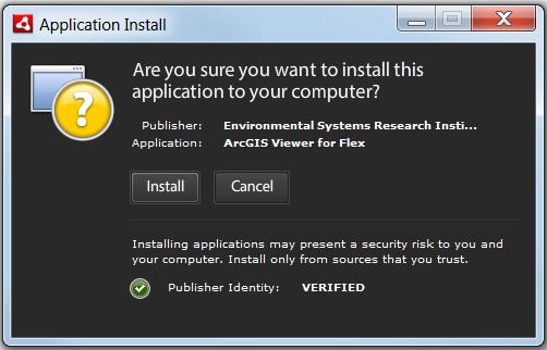
10 ArcGIS Viewer for Flex Two methods to build an application Configurable Viewer Download a deployable viewer Manually edit configuration files Application Builder Install a program Use a wizard-driven user interface to build and modify a viewer

11 Configurable Viewer Title Subtitle Logo Widget tray Map Switcher widget Navigation widget Scalebar
 Overview Map")
12 Configurable Viewer Open widget (from Widget tray) Overview Map widget

13 Resource Center Download software, documentation, widgets, samples, user forums
14 Demonstration 1 Explore a deployed Web application
15 Review and Questions Explore a deployed Web application
16 2) Creating Web Applications with Application Builder
17 Application Builder Provides GUI user experience to configure and deploy the Viewer Built on Adobe AIR technology Interactively configure: Data Content Functionality Appearance


18 Start with Application Builder Download and run the installer Initial page manages your applications


19 Application Builder: Tabs Five control tabs Define functionality and look and feel Non-linear workflow Maps tab Widgets tab Layout tab Design tab Preview tab


20 Application Builder: Maps tab Maps tab Specify data content ArcGIS.com Web Maps or Basemaps & Operational Layers


21 Widgets Viewer application functionality defined by widgets Many core widgets included Each widget is configurable No programming required Use a select group of widgets to create custom Web clients that address specific business workflows Build focused Web mapping applications Lego-like approach to client development Application Builder manage using Widgets tab
22 Core functional widgets Bookmark Data Extract Draw Edit GeoRSS Layer List Locate Print Query Search Time Slider Geoprocessing


23 Core UI widgets Header controller Map switcher Navigation Overview map


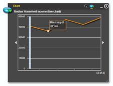

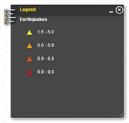
24 Core UI widgets Coordinates Legend Splash screen Chart
25 Demonstration 2 Build a new ArcGIS Viewer for Flex using the Application Builder
26 Review and Questions Build a new ArcGIS Viewer for Flex using the Application Builder
27 3) Configure and extend the ArcGIS Viewer for Flex
28 ArcGIS Viewer for Flex: Users 1. Novice Web application creators Use Application Builder to build and deploy the viewer > GIS Analysts, Managers 2. Configurators Advanced Viewer configuration Leverage existing widgets > GIS Analysts, Web Site Designers, Managers 3. Developers Extend Viewer functionality > Business Partners, Web Site Developers, Flex API developers
29 Configure the Viewer Advanced customization by editing the Viewer configuration file General properties UI elements Map properties Spatial extent Data content Edit config.xml file Appearance Functionality Data content Widget container Widgets

 file Customize widget by editing its")
30 Configure viewer widgets Widgets modular functionality XML configuration file Compiled Flash (.swf) file Customize widget by editing its configuration file Edit BookmarkWidget.xml file
31 Developing the Viewer Requirements Adobe Flex SDK 4.x Flash Player 10.0 IDE (Flash Builder 4) ArcGIS API for Flex Application and widget source code available Common patterns Change behavior of existing widgets Create new widgets Extend Viewer application Flash Player Flash Builder
32 Demonstration 3 Modify the viewer configuration file Extend application functionality with widgets
33 Summary In this Web Seminar you learned about... Configurable ready-to-deploy Web client > Complete set of core GIS tools and functionality Interactively create Web applications Configurable Viewer modify configuration files Application Builder WYSIWYG experience Simple customizations by editing configuration files Can be further extended with ArcGIS API for Flex
34 Thank You If you have any additional questions about the content presented to you, feel free to contact me: Greg Yetman
Web Mapping Applications with ArcGIS. Bernie Szukalski Derek Law
 Web Mapping Applications with ArcGIS Bernie Szukalski Derek Law Agenda Web Mapping and Map Services Fundamentals ArcGIS Web Mapping Applications - Hosted online - Hosted on-premise Summary Web Application
ArcGIS Viewer for Microsoft Silverlight An Introduction
 Esri International User Conference San Diego, CA Technical Workshops July 12, 2011 ArcGIS Viewer for Microsoft Silverlight An Introduction Art Haddad, Rich Zwaap, and Derek Law Agenda Background Product
Creating Web Mapping Applications. Nikki Golding
 Creating Web Mapping Applications Nikki Golding Agenda Web Mapping and Map Services Fundamentals ArcGIS Web Mapping Applications - ArcGIS.com Viewer - ArcGIS Explorer Online - ArcGIS Viewer for Flex -
No Programming Required Create web apps rapidly with Web AppBuilder for ArcGIS
 No Programming Required Create web apps rapidly with Web AppBuilder for ArcGIS By Derek Law, Esri Product Manager, ArcGIS for Server Do you want to build web mapping applications you can run on desktop,
Getting Started with ArcGIS for Server. Charmel Menzel and Ken Gorton
 Getting Started with ArcGIS for Server Charmel Menzel and Ken Gorton Agenda What is ArcGIS for Server? Types of Web services Publishing resources onto the Web Clients to ArcGIS for Server Editions and
Web App Builder: Code-free Development. Adam Ziegler, Esri-Northeast, Local Government Team
 Web App Builder: Code-free Development Adam Ziegler, aziegler@esri.com Esri-Northeast, Local Government Team Agenda Product overview Web AppBuilder for ArcGIS tour Adding Custom Widgets Community and Resources
ArcGIS Viewer for Flex An Introduction
 2013 Esri International User Conference July 8 12, 2013 San Diego, California Technical Workshop ArcGIS Viewer for Flex An Introduction Bjorn Svensson and Heather Gonzago @Bjorn_Svensson @hgonzago Esri
Web AppBuilder for ArcGIS: JavaScript Apps Made Easy
 Web AppBuilder for ArcGIS: JavaScript Apps Made Easy Ryan Sellman @rcsellman Agenda Product overview Web AppBuilder for ArcGIS tour Customization Community and Resources Summary The ArcGIS Platform enables
Web AppBuilder Presented by
 Web AppBuilder Presented by Agenda Product overview Web AppBuilder for ArcGIS tour What s new in the ArcGIS Online June 2016 update Customization Community and Resources Summary The ArcGIS Platform enables
Introduction to Web AppBuilder for ArcGIS: JavaScript Apps Made Easy
 Introduction to Web AppBuilder for ArcGIS: JavaScript Apps Made Easy Jianxia Song & Derek Law July 21, 2015 Agenda Product overview Web AppBuilder for ArcGIS tour What s New July 2015 ArcGIS Online update
Interactive webmaps with ArcGIS. Kristel Meikas, AlphaGIS
 Interactive webmaps with ArcGIS Kristel Meikas, AlphaGIS Agenda Overview of ArcGIS tools and resources Introduction to ArcGIS APIs In depth with Flex maps In depth with JavaScript maps ArcGIS Server Publish
What s New in ArcGIS Server 10
 What s New in ArcGIS Server 10 Derek Law ArcGIS Server Product Management What s s new in ArcGIS Server 10? Agenda Highlights: Enhanced Web mapping More powerful server-based analysis Geo-collaboration
EUCOM/AFRICOM DEFENSE USER GROUP MEETING MARCH 2010 STUTTGART WELCOME!
 EUCOM/AFRICOM DEFENSE USER GROUP MEETING 23-25 MARCH 2010 STUTTGART WELCOME! AGENDA March 23, Tuesday 0800-0900 Registration 0900-0915 Welcome and Introductions 0915-1000 Getting Started with ArcGIS Server
Configuring and Customizing the ArcGIS Viewer for Silverlight. Katy Dalton
 Configuring and Customizing the ArcGIS Viewer for Silverlight Katy Dalton kdalton@esri.com Agenda Overview of the ArcGIS Viewer for Silverlight Extensibility endpoints - Tools, Behaviors, Layouts, Controls
Author. Publish. Use
 Building Mashups Using the ArcGIS Web APIs Heather Gonzago Garima Vyas Agenda g Overview: Web Maps Overview: ArcGIS API for REST ArcGIS API for JavaScript p Google Maps Extension Bing Maps Extension ArcGIS
What s s Coming in ArcGIS 10 Desktop
 What s s Coming in ArcGIS 10 Desktop Damian Spangrud ArcGIS Product Manager, ESRI dspangrud@esri.com (or at least turn to silent) ArcGIS 10 A Simple & Pervasive System for Using Maps & Geographic Information
Introduction to ArcGIS Server 10.1
 Introduction to ArcGIS Server 10.1 E-Learning for the GIS Professional Any Time, Any Place! geospatialtraining.com Module Outline What is ArcGIS Server? GIS Resources and Services ArcGIS Server Components
An Introduction to GIS for developers
 An Introduction to GIS for developers Part 4: GIS Sharing Canserina Kurnia & Tom Shippee Agenda Web GIS ArcGIS Online Cloud-based ArcGIS Server ArcGIS Server on-premises ArcGIS a complete platform discover,
Introduction to ArcGIS API for Flex. Bjorn Svensson Lloyd Heberlie
 Introduction to ArcGIS API for Flex Bjorn Svensson Lloyd Heberlie Agenda API Introduction Getting started API concepts and examples Getting more information API Introduction ArcGIS 10 A Complete System
ArcGIS Viewer for Silverlight Advanced Topics
 Esri International User Conference San Diego, California Technical Workshops July 26, 2012 ArcGIS Viewer for Silverlight Advanced Topics Rich Zwaap Agenda Add-ins overview Tools Behaviors Controls Layouts
Getting Started with the ArcGIS Server JavaScript API
 Getting Started with the ArcGIS Server JavaScript API Agenda Introduction ArcGIS Server services and mashups REST API Services Directory JavaScript API ArcGIS Server Resource Center Dojo Maps, layers,
ICIT. Brian Hiller ESRI Account Manger. What s new in ArcGIS 10
 ICIT Brian Hiller ESRI Account Manger What s new in ArcGIS 10 ArcGIS 10 Fast Easy Powerful Everywhere late June 2010 ArcGIS System for Geographic Information Desktop Server Mobile Online A System A Complete
ArcGIS Online. The Road Ahead Geoff Mortson
 ArcGIS Online The Road Ahead Geoff Mortson gmortson@esricanada.com ArcGIS Online Easily create and share maps Delivered as intelligent maps Access on virtually any device anyone, anywhere Compliments and
ArcGIS Viewer for Flex Advanced Topics
 Esri International User Conference San Diego, California Technical Workshops July 27, 2012 ArcGIS Viewer for Flex Advanced Topics Lloyd Heberlie Björn Svensson Before we begin Who are we? - Bjorn Svensson
Leveraging OGC Services in ArcGIS Server. Satish Sankaran, Esri Yingqi Tang, Esri
 Leveraging OGC Services in ArcGIS Server Satish Sankaran, Esri Yingqi Tang, Esri GIS Creating and Managing Geo Information Products - Proprietary - Open Specifications - Standards Dissemination of Geo
Real-Time GIS: Leveraging Stream Services
 Real-Time GIS: Leveraging Stream Services Mark Bramer Senior Technical Analyst Esri Professional Services mbramer@esri.com RJ Sunderman Product Engineer GeoEvent Extension Product Team rsunderman@esri.com
ArcGIS API for Flex An Introduction
 Esri International User Conference San Diego, California Technical Workshops July 25, 2012 ArcGIS API for Flex An Introduction Lloyd Heberlie Heather Gonzago Before we begin Who are we? - Heather Gonzago
ArcGIS SDK for Windows Phone and ArcGIS for SharePoint. Jo Fraley Nikki Golding
 ArcGIS SDK for Windows Phone and ArcGIS for SharePoint Jo Fraley Nikki Golding ArcGIS for SharePoint Agenda Welcome / Introductions ArcGIS for SharePoint Demo - Working with the product Road map ArcGIS
Building Applications with the ArcGIS Runtime SDK for WPF
 Esri International User Conference San Diego, California Technical Workshops 24 th July 2012 Building Applications with the ArcGIS Runtime SDK for WPF Euan Cameron & Paul Pilkington Agenda Introduction
Building Mashups Using the ArcGIS APIs for FLEX and JavaScript. Shannon Brown Lee Bock
 Building Mashups Using the ArcGIS APIs for FLEX and JavaScript Shannon Brown Lee Bock Agenda Introduction Mashups State of the Web Client ArcGIS Javascript API ArcGIS API for FLEX What is a mashup? What
Esri Developer Summit in Europe Building Applications with ArcGIS Runtime SDK for Java
 Esri Developer Summit in Europe Building Applications with ArcGIS Runtime SDK for Java Mark Baird Mike Branscomb Agenda Introduction SDK Building the Map Editing Querying Data Geoprocessing Asynchronous
Tom Brenneman. Good morning and welcome, introductions and thank you for being here.
 Welcome Tom Brenneman Good morning and welcome, introductions and thank you for being here. This is a best practices seminar. We're going to be sharing with you what we found to be best practices that
Best Practices for Creating Web Maps. Brian Chong Justin Fan
 Best Practices for Creating Web Maps Brian Chong Justin Fan Agenda Overview of web maps Designing maps for the web Develop effective web maps What is a Web Map? Contains one or more GIS services Integrated
SDI SOLUTIONS FOR INSPIRE: TECHNOLOGIES SUPPORTING A FRAMEWORK OF COOPERATION
 SDI SOLUTIONS FOR INSPIRE: TECHNOLOGIES SUPPORTING A FRAMEWORK OF COOPERATION Roberto Lucchi 1, Marten Hogeweg 1, Guenther Pichler 2 1 Esri, Redlands, CA, USA 2 Esri Kranzberg, Germany 1 Vision INSPIRE
SAW Stand-alone Application for Web GIS Configuration and Deployment. PhD. Bogdan Cheveresan Esri Romania
 SAW Stand-alone Application for Web GIS Configuration and Deployment PhD. Bogdan Cheveresan Esri Romania Web GIS Workflow Without SAW esri.com Desktop GIS User ArcGIS Server Administrator and Web GIS Programmer
ArcGIS API for Silverlight An Introduction
 Esri Middle East and Africa User Conference December 10 12 Abu Dhabi, UAE ArcGIS API for Silverlight An Introduction Jo Fraley Agenda Silverlight platform API Overview Building Apps Road Ahead ArcGIS is
Using ArcGIS for Server. Javier Abadía, Esri España Peter McDaid, Esri UK
 Using ArcGIS for Server Javier Abadía, Esri España Peter McDaid, Esri UK 1. Intro 2. ArcGIS for Server = Geospatial Apps Server 3. Map Services Publishing Flow Apps 4. Spatial Functionality Services Publishing
Customizing Web AppBuilder using Third Party Products. Presented to: Esri Canada Toronto UC Presented by: Maura Daffern October 11 th, 2018
 Customizing Web AppBuilder using Third Party Products Presented to: Esri Canada Toronto UC Presented by: Maura Daffern October 11 th, 2018 Introduction Third Party Products? Who Am I? Agenda What is the
Working with Feature Layers. Russell Brennan Gary MacDougall
 Working with Feature Layers Russell Brennan Gary MacDougall Working with Feature Layers Session will focus on feature access and editing Highlight new features added over the last few releases Agenda Introduction
Providing Interoperability Using the Open GeoServices REST Specification
 2013 Esri International User Conference July 8 12, 2013 San Diego, California Technical Workshop Providing Interoperability Using the Open GeoServices REST Specification Satish Sankaran Kevin Sigwart What
ArcGIS Runtime SDK for WPF
 Esri Developer Summit in Europe November 9 th Rotterdam ArcGIS Runtime SDK for WPF Mike Branscomb Mark Baird Agenda Introduction SDK Building the Map Query Spatial Analysis Editing and Geometry Programming
ArcGIS for Mobile An Introduction. Bonnie Stayer
 ArcGIS for Mobile An Introduction Bonnie Stayer Benefits of mobile GIS? Accessibility Timely Decisionmaking Efficiency and Accuracy Rapid Data Collection Types of mobile solutions? Apps & APIs Functionality
Extend GIS. The Reach. Of Your GIS. Chris Cappelli Nathan Bennett
 Extend The Reach GIS Of Your GIS Chris Cappelli Nathan Bennett Where do your co-workers, managers, customers, and citizens go when they want to find or make a map? GIS is a practical system for problem
Leveraging Esri Web AppBuilder s Free Widgets in Your Web GIS
 Leveraging Esri Web AppBuilder s Free Widgets in Your Web GIS Dan Loegel, GISP Implementation Specialist GeoNexus Technologies June 18, 2018 Agenda 1. What is Web AppBuilder 2. The Basics 3. Widgets 4.
Getting Started with the ArcGIS API for JavaScript. Julie Powell, Paul Hann
 Getting Started with the ArcGIS API for JavaScript Julie Powell, Paul Hann Esri Developer Summit Berlin November 19 2012 Getting Started with the ArcGIS API for JavaScript ArcGIS for Server Is a Platform
IndianaMap Release 3. Rick Hill, Paul Rohwer,, Chris Dintaman, Becky Meyer, and Denver Harper
 IndianaMap Release 3 Rick Hill, Paul Rohwer,, Chris Dintaman, Becky Meyer, and Denver Harper IndianaMap Agenda Session 1 & 2 Overview Tentative rollout schedule Old versus New Design and construction of
Publishing Story Maps with ArcGIS
 Publishing Story Maps with ArcGIS Agenda This seminar is designed to help you understand: 1) Introducing story maps 2) Creating story maps using templates 3) Hosting story maps with ArcGIS Online Introducing
Free to download and distribute from
 Topics for this session Introduction Overview of features Using ArcGIS Explorer effectively Customization New features & capabilities Demonstrations *Note: Explorer 1200 What is ArcGIS Explorer GIS for
ArcMap: Tips and Tricks
 Esri International User Conference San Diego, California Technical Workshops July 23 27, 2012 ArcMap: Tips and Tricks Miriam Schmidts Jorge Ruiz-Valdepena Agenda Navigating ArcMap Repairing data links
How to become an INSPIRE node and fully exploit the investments made?
 How to become an INSPIRE node and fully exploit the investments made? Solution patterns for consumers: end users & developers (2/2) Roberto Lucchi 22 June 2010, Krakow 1 Geoportal extension Enabling discovery
DATA SHARING AND DISCOVERY WITH ARCGIS SERVER GEOPORTAL EXTENSION. Clive Reece, Ph.D. ESRI Geoportal/SDI Solutions Team
 DATA SHARING AND DISCOVERY WITH ARCGIS SERVER GEOPORTAL EXTENSION Clive Reece, Ph.D. ESRI Geoportal/SDI Solutions Team Geoportal Extension for ArcGIS Server Context within an Enterprise Spatial Data Infrastructure
Modernizing California State Highway Right of Way Records with GIS. Caltrans District 4 Oakland, CA
 Modernizing California State Highway Right of Way Records with GIS Caltrans District 4 Oakland, CA About Us Kirsten Lawrence (GISP), Senior Geospatial Analyst on staff augmentation contract with Caltrans
ArcGIS Web Viewers and Templates. Andy Gup, Jim Barry
 ArcGIS Web Viewers and Templates Andy Gup, Jim Barry What s new in the ArcGIS Viewer for Flex Andy Gup, Jim Barry ArcGIS Viewer for Flex ArcGIS API for Flex ArcGIS Online / Portal / Orgs ArcGIS Server
ESRI Software Evolution
 ArcGIS Jan Šlahař About ESRI ESRI - Environmental Systems Research Institute Founded in 1969, Redlands, California In 2002 Esri had approximately a 36 percent share of the GIS software market worldwide
Operations Dashboard for ArcGIS Monitoring GIS Operations. Michele Lundeen Esri
 Operations Dashboard for ArcGIS Monitoring GIS Operations Michele Lundeen Esri mlundeen@esri.com What is a dashboard? Conceptual term, can mean different things to different audiences Dashboards provide
What s New for Developers in ArcGIS Maura Daffern October 16
 What s New for Developers in ArcGIS 10.1 Maura Daffern October 16 mdaffern@esri.ca Today s Agenda This seminar is designed to help you understand: 1) Using Python to increase productivity 2) Overview of
Creating Transparency, Openness and Trust: Modern Approach to Redistricting
 Creating Transparency, Openness and Trust: Modern Approach to Redistricting Richard Leadbeater, Esri Jerry Howe, Utah Legislature Larry Boden, Esri NCSL Legislative Summit Sunday, Aug. 6 11:15 am-12:15
SuperGIS Server 3.2 Value Edition Specification
 SuperGIS Server 3.2 Value Edition Specification 20140826 Specification 1. All of the services support SOAP (Simple Object Access Protocol). 2. Use map file created by SuperGIS Desktop as map services SuperGIS
Desktop. ArcGIS Server. ArcGIS
 Getting Started with ArcGIS Server Nakul Bhatia and David Crosby ESRI Charlotte 1 Agenda g Overview of ArcGIS Server 9.3.1 Working with GIS Services Using g Web GIS Service Clients ArcGIS Online Map Caching
TACCIMO A CASE STUDY OF MIGRATING TO THE ARCGIS SERVER API FOR FLEX
 TACCIMO A CASE STUDY OF MIGRATING TO THE ARCGIS SERVER API FOR FLEX Todd Pierce, Jeff Hicks, Amber Ramirez, Caroline Dougherty UNC Asheville s National Environmental Modeling and Analysis Center Jennifer
Web GIS: Principles and Applications. Pinde Fu, Ph.D. Project Lead / Senior Developer Professional Services Division
 Web GIS: Principles and Applications Pinde Fu, Ph.D. pfu@esri.com Project Lead / Senior Developer Professional Services Division 2 Web GIS: Principles and Applications Pinde Fu & Jiulin Sun Web GIS course
Introduction to ArcGIS Online and Story Maps
 Introduction to ArcGIS Online and Story Maps Presented by the University of Connecticut s Center for Land Use Education and Research (CLEAR) CLEAR 1 Welcome! Instructor Introductions Course logistics Student
Chapter 20: Basic Application Design with Dojo and ArcGIS Templates
 Chapter 20: Basic Application Design with Dojo and ArcGIS Templates One of the most difficult tasks for many web developers building GIS applications is designing and creating the user interface. The ArcGIS
GNAHRGIS MAP MIGRATION
 GNAHRGIS MAP MIGRATION GNAHRGIS Map Use Guide https://www.gnahrgis.org November, 2016 Contents 1 Overview... 2 2 GNAHRGIS Resource Access... 4 3 GNAHRGIS Widgets replaced with Map Tools... 5 December 10,
A Developers Guide To Mobile GIS. David Cardella, Jeff Shaner
 A Developers Guide To Mobile GIS David Cardella, Jeff Shaner What is mobile GIS? Extends the reach of ArcGIS from the office to the field With a mobile GIS solution you can: - Carry your maps to the field
Designing and Using Basemaps. Jennifer Hughey
 Designing and Using Basemaps Jennifer Hughey Agenda The ArcGIS System Basemaps are a key component of your system Cartographic design considerations Using basemap layers in ArcMap Best practices for designing
County of Los Angeles. Chief Information Office Preferred Technologies for Geographic Information Systems (GIS) Version 2 May 2015
 Version 2 May 2015") County of Los Angeles Chief Information Office Preferred Technologies for Geographic Information Systems (GIS) Version 2 May 2015 CIO Preferred Technologies for GIS This document lists the preferred Geographic
County of Los Angeles Chief Information Office Preferred Technologies for Geographic Information Systems (GIS) Version 2 May 2015 CIO Preferred Technologies for GIS This document lists the preferred Geographic
Developers Road Map to ArcGIS Desktop and ArcGIS Engine
 Developers Road Map to ArcGIS Desktop and ArcGIS Engine Core ArcObjects Desktop Team ESRI Developer Summit 2008 1 Agenda Dev Summit ArcGIS Developer Opportunities Desktop 9.3 SDK Engine 9.3 SDK Explorer
Esri Maps for SharePoint
 Esri International User Conference San Diego, California Technical Workshops July, 2012 Esri Maps for SharePoint Art Haddad Nathan Bennett Agenda Location Analytics - Esri Maps for SharePoint - Overview
Accessing OGC Services To access OGC WMS and WFS open the service in the directory that you want to consume, and click on either WMS or WFS.
 Using Web Services Web Services Overview This user guide contains instructions on how to consume a range of services through a range of both web based and desktop GIS applications. Web services are a live
Serving Imagery with ArcGIS Server 10.1
 Serving Imagery with ArcGIS Server 10.1 Presented by: André Piasta apiasta@esri.ca Esri Canada Users Conference Calgary, AB 28 May 2013 Today s Agenda ArcGIS server and image services Publishing of imagery
ArcGIS 10.1 for Desktop Artie Robinson
 ArcGIS 10.1 for Desktop Artie Robinson ArcGIS A Complete System for Geographic Information Cloud Web Online Mobile Enterprise Desktop Name Change Name Prior to 10.1 ArcGIS Desktop ArcInfo ArcEditor ArcView
Juniata County, Pennsylvania
 GIS Parcel Viewer Web Mapping Application Functional Documentation June 21, 2017 Juniata County, Pennsylvania Presented by www.worldviewsolutions.com (804) 767-1870 (phone) (804) 545-0792 (fax) 115 South
SIX REASONS. You Should Use ArcGIS API 4.0 for JavaScript. By Julie Powell, Esri Product Management
 SIX REASONS You Should Use ArcGIS API 4.0 for JavaScript By Julie Powell, Esri Product Management Since 2008, developers have used ArcGIS API for JavaScript to build powerful web mapping applications.
Interoperability and Standards Supports in ArcGIS
 Esri International User Conference San Diego, California Technical Workshops July 26, 2012 Interoperability and Standards Supports in ArcGIS Satish Sankaran, Esri Yingqi Tang, Esri Agenda Esri s participation
The Now Platform Reference Guide
 The Now Platform Reference Guide A tour of key features and functionality START Introducing the Now Platform Digitize your business with intelligent apps The Now Platform is an application Platform-as-a-Service
Introduction to ArcGIS Server Architecture and Services. Amr Wahba
 Introduction to ArcGIS Server 10.1 - Architecture and Services Amr Wahba awahba@esri.com Agenda Architecture Features Publishing Security Cloud Powerful GIS capabilities Delivered as Web services To help
An introduction to ArcGIS Runtime
 2013 Europe, Middle East, and Africa User Conference October 23-25 Munich, Germany An introduction to ArcGIS Runtime Christine Brunner Lars Schmitz Welcome! Christine Brunner, Germany - Software Developer
IMAGERY FOR ARCGIS. Manage and Understand Your Imagery. Credit: Image courtesy of DigitalGlobe
 IMAGERY FOR ARCGIS Manage and Understand Your Imagery Credit: Image courtesy of DigitalGlobe 2 ARCGIS IS AN IMAGERY PLATFORM Empowering you to make informed decisions from imagery and remotely sensed data
Leveraging OGC Services in ArcGIS Server
 Esri International User Conference San Diego, CA Technical Workshops Jul.14 th 2011 Leveraging OGC Services in ArcGIS Server Satish Sankaran Yingqi Tang Agenda Interoperability
Review of File Management and Introduction to ArcGIS
 Review of File Management and Introduction to ArcGIS RNR/GEOG 417/517 Overview of Presentation Discuss the objectives of the lab exercise Introduce the class directory structure General file policies Introduce
GeoPlanner Workshop. Esri Ocean GIS Forum November 4, Pete Aniello and Rob Stauder
 GeoPlanner Workshop Esri Ocean GIS Forum November 4, 2015 Pete Aniello and Rob Stauder Purpose and Take-aways Learn how to: - Create services - Use services in ArcGIS Online - Use services in GeoPlanner
Leveraging OGC Services in ArcGIS Server. Satish Sankaran Yingqi Tang
 Leveraging OGC Services in ArcGIS Server Satish Sankaran ssankaran@esri.com Yingqi Tang ytang@esri.com Agenda Interoperability Enablers OGC and esri OGC Web Services ArcGIS and OGC Web Services - @ version
ArcGIS Enterprise Extending Services. Bill Major
 ArcGIS Enterprise Extending Services Bill Major Agenda Introduction Geoprocessing tools Server Object Extensions Server Object Interceptors Demo APPS Desktop Web Device SHARING SERVICES Portal API DATA
Nick Tonias, P.E. The CEDRA Corporation. Ian Peebles, GISP The City of Edmond
 Nick Tonias, P.E. The CEDRA Corporation Ian Peebles, GISP The City of Edmond u u u u u u Brief Intro to CEDRA and City of Edmond Creating Apps using ArcGIS Online Creating Apps using ArcGIS Serer Presentation
ArcGIS for Developers: An Introduction. Moey Min Ken
 ArcGIS for Developers: An Introduction Moey Min Ken AGENDA Is development right for me? Building Apps on the ArcGIS platform Rest API & Web API Native SDKs Configurable Apps and Builders Extending the
What s New in ArcGIS 10.4 for Server
 What s New in ArcGIS 10.4 for Server Derek Law, Esri Jan 19, 2016 Esri Southwest User Conference Agenda Product story GIS Server Sharing content from ArcGIS Pro Portal for ArcGIS Client Apps Summary Strongly
3D in the ArcGIS Platform. Chris Andrews
 3D in the ArcGIS Platform Chris Andrews Geospatial 3D is already all around us 3D is expanding the GIS community s opportunity to provide value 3D City & Infrastructure Models Generated 3D features Photogrammetrc
Developing Web Applications with ArcGIS Server. Kevin Deege Educational Services ESRI-Washington DC
 Developing Web Applications with ArcGIS Server Kevin Deege Educational Services ESRI-Washington DC Introductions Who am I? Who are you? ESRI Product Development Experience What development languages are
Chapter 9: Integrating Widgets
 Chapter 9: Integrating Widgets The API for JavaScript comes with several out of the box widgets that you can drop into your application for enhanced productivity. Included are the BasemapGallery, Legend,
ArcGIS App Strategies Ben
 ArcGIS App Strategies Ben Ramseth Bramseth@esri.com @esrimapninja DevSummit DC February 26, 2016 Washington, DC Session overview Topics Understanding ArcGIS s Defining strategies for building s Applying
ArcGIS Runtime SDK for.net Getting Started. Jo Fraley
 ArcGIS Runtime SDK for.net Getting Started Jo Fraley Agenda What is the ArcGIS Runtime? What s new for ArcGIS developers? ArcGIS Runtime SDK 10.2 for WPF ArcGIS Runtime SDK for.net Building Windows Store
What s New in Desktop 10.1
 What s New in Desktop 10.1 Damian Spangrud Esri Redlands Trip Down Memory Lane ArcGIS A Complete System for Geographic Information Cloud Web Online Mobile Enterprise Desktop Sharing Information sharing
Flex 3 Pre-release Tour
 Flex 3 Pre-release Tour Andrew Shorten shorten@adobe.com Enrique Duvos duvos@adobe.com Flex 3 Pre-release Tour Agenda Adobe Platform Update (45 mins) Flex Builder 3 Features (45 mins) Adobe & Open Source
ESRI Technology Update. Joe Holubar Larry Young
 ESRI Technology Update Joe Holubar Larry Young Continued Improvement Improving Quality and Extending and Refining Functionality First Half of 2009: Minor Update Release (ArcGIS 9.3.1) ArcGIS Explorer Fall
Agenda. Introduction. Supported Formats. Creating a Custom REST Service. What s Next
 Using the ArcGIS Server REST API Jeremy Bartley Keyur Shah Agenda Introduction Design and Concepts Supported Formats REST API Admin Creating a Custom REST Service What s New (Since 9.3) What s Next Conclusion
ArcGIS 9.2 Works as a Complete System
 ArcGIS 9.2 Works as a Complete System A New Way to Manage and Disseminate Geographic Knowledge Author/Serve/Use Maps Data Models Globes Metadata Use Desktop Explorer Web Map Viewer Mobile Open APIs Enterprise
Building Applications with ArcGIS Runtime SDK for ios - Part I. Divesh Goyal Mark Dostal
 Building Applications with ArcGIS Runtime SDK for ios - Part I Divesh Goyal Mark Dostal Agenda The ArcGIS System Using the Runtime SDK for ios - Display Maps - Perform Analysis - Visualize Results Q&A
ArcGIS Enterprise: Architecture & Deployment. Anthony Myers
 ArcGIS Enterprise: Architecture & Deployment Anthony Myers 1 2 3 4 5 Web GIS Overview of ArcGIS Enterprise Federation & Hosted Server Deployment Patterns Implementation 1 Web GIS ArcGIS Enabling GIS for
Creating Apps Using ArcGIS Online Templates. Matt Kennedy
 Creating Apps Using ArcGIS Online Templates Matt Kennedy Topics we will cover The publishing process Before you publish Where apps live Breakdown of apps Publishing web app templates The steps for publishing