The Reykjavik GIS project
|
|
|
- Phyllis Glenn
- 6 years ago
- Views:
Transcription


1 The Reykjavik GIS project Jörgen Þormóðsson - Manager of LUKR Stefán Guðlaugsson - GIS-manager of Samsýn City of Reykjavik Department of Environment and Planning Division of Geodesy and Geoinformatics
?")

2 What is LUKR? What is Borgarvefsjá (CityWebView)? What is Borgarsjá (CityView)? What is Skipulagssjá (CityPlannigView)? Technical overview
3 What is LUKR? LUKR is an abbreviation for Landupplýsingakerfi Reykjavíkur (The Land Information System of the Reykjavik Area). LUKR is a cooperative project of the technical departments of The City of Reykjavik (52%), Reykjavik Energy (36%) and Míla Telecom Company (12%). The task: Management and Development of the Reykjavik GIS.
4 More about LUKR The buildings and lots in LUKR are connected to corresponding records in the Building Inspector's database, the National Real Estate Registry and the National Population Registry. LUKR spans 15 basic themes (layers), more than 200 others themes and more than 100 tables. LUKR covers the Reykjavik municipality area of 270 km², including an urban area of 45 km². The total population of the Reykjavik urban area is about inhabitants, thereof about reside in the City of Reykjavik.
5 The Development of LUKR 1 st S T A G E 2 nd S T A G E Formal co-operation begins Feb City Council decides to start LUKR project July 1989 Arc/Info software from ESRI chosen in open bidding Nov Beginning of general data input May 1990 High speed connections between LUKR participants Des Input of all basic data themes finished Jan Data delivery on the Internet Feb Usage of SDE (Spatial Database Engine) from 1997 Development of City View on PC-Windows Development of City WebView on the Internet from 1999 Development of City PlannigView on the Internet from 2003 Dev. of City View on Internet with ArcGIS Server from 2004 Development of more web services with ArcGIS Server from 2007 (LUKR Time Machine 2008, Public Works Map Viewer 2011)
6 Cooperation, Coordination and Interconnection These three keystones must be kept in mind all the time if a GIS shall get maximal usefulness. Coordinated data, contact persons, committees and high speed connections make all the LUKR layers acting as a whole. Meetings are hold regularly: - Technical meetings about once a month. - Board meetings twice a year.

7 Organization Chart of LUKR The LUKR Board 9 representatives from companies Consultants Manager of LUKR Contact persons in the companies Technical Manager of LUKR Subcommittees for special tasks Technical Committee 11 employees from the companies People responsible for the databases in the companies/departments Employees in the companies/departments An agreement of co-operation has been signed, defining the roles and responsibilities of the participants in details.

8 Connections between LUKR and outer databases Real Estate File National Register (NR) Address database Register of businesses NR Number Buildings Streets Accident database Assessment Unit Number Parcel Number ERINDREKI Parcels Cables & pipelines Oracle Reykjavik Energy Telecom Company Building Inspector s database
9 What is Borgarvefsjá? Borgarvefsjá (City WebView) is a simple information system on the Web. It is based on ArcGIS Server and the LUKR data and gives access to various information about Reykjavik. Borgarvefsjá gives the public access to information about houses, lots, streets, areas, lots drawings, streets drawings, buildings drawings, etc. It s also possible to look at aerial photos, find an address on the map, get information of pipelines/cables, measure distances or areas, store locations, etc. Borgarvefsjá is accessible for the public on the Web. The Web path is:

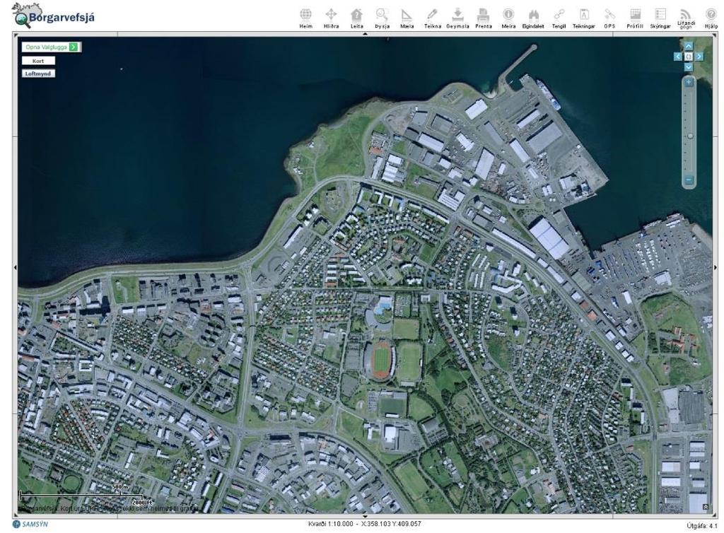


10 City WebView (Borgarvefsjá) - content Map display and features Theme selection Map and Aerial photo switch Search for addresses or streets Measure coordinates, lengths and areas Store and retrieve locations Display utilities Query attributes Display drawings Print maps


11 City WebView-app (Borgarvefsjá) - content Map display and features Theme selection Query attributes Search for addresses or streets Measure coordinates, lengths and areas

12 LUKR Time Machine (Tímavél LUKR) Compares LUKR databases at two different points in time. Based on database snapshots taken December 1st every year since Possibility to slide over time to see changes gradually. Print comparative maps.
13 What is Borgarsjá? Borgarsjá (City View) is an easy but powerful Web application where you can get access to many kinds of information about Reykjavik and vicinity. Borgarsjá is based on ArcGIS Server, giving many possibilities, like access control of information. Borgarsjá is a tool for looking at and querying or combining information from LUKR, Building Inspector s database, the Real Estate File for Iceland and the National Registry. Borgarsjá is accessible for all employees of the City of Reykjavik and the Reykjavik Energy and others according to agreements.


")


14 City of Reykjavik Department of Environment and Planning City View (Borgarsjá) - content Map display and features Building classification Demography and development ratio Parcel Information Info from National Register Planning and building info Utilities Query builder
15 What is Skipulagssjá Skipulagssjá (City Planning View) gives the public users information about master plan and local plans. Skipulagssjá (City Planning View) is based on ArcGIS Server. Skipulagssjá (City Planning View) is a tool that gives informations about local planning by connection to scanned papers and maps. The master plan is however build in geodatabase. Skipulagssjá (City Planning View) is accessible for the public on the Web.
 -")


16 City Planning View (Skipulagssjá) - content Map display and features Further information about local plan area Open scanned document Master plan Statistical informations about selected area
17 Access to LUKR data Since 1997 LUKR data has been available on the Web. Users had to pay license fee until the year Now all data is free and available for everone. Part of Reykjavik City open data policy. Private companys and individuals can use the data in new way and in a new context - and then increase the value. Possibly even create new jobs. We get more feedback on our data to make them more accurate.

18 Data delivery on the Web LUKR has a Web page where it is possible to download zipped shapefiles of 44 themes from LUKR. Themes are updated few times every year.


19 Data delivery on the Web Úttektarkerfi LUKR - Web application to deliver data to LUKR clients. After logging in user selects: 1. File Type (Shape or dxf) 2. Layers 3. Area 4. Coordinate system (National or local) Data is extracted and zipped.
 Live information of snowplowing.")
20 A few examples of how LUKR is used (1) Live information of snowplowing.

21 A few examples of how LUKR is used (2) Percent of kids that practice sport with each local team

22 A few examples of how LUKR is used (3) Heatmap of rat-incidents compared with age of the sewage system
 Graffiti and tags in city")
23 A few examples of how LUKR is used (4) Graffiti and tags in city center

24 A few examples of how LUKR is used (5) People were able to map their cycling path to work - the result was used to plan new cycling paths.
25 The Benefits of LUKR Information source both for specialists and for the general public. Base for data processing and research. Aid for management and decision making. Coordinating tool for institutions, departments and companies. Aid for teaching.... and the Goals of LUKR To stay among the leaders in GIS world. Serving employees and general public as well as possible.
26 Technical Overview Software ArcGIS 10.x used by everybody ArcSDE 10.0 (soon to be upgraded) ArcGIS Server (upgrade in progress) ArcGIS Desktop ArcGIS Online in beginning phase Web clients ArcGIS API for Javascript ArcGIS API for Flex (in process of being replaced) ArcGIS API for Silverlight (already been replaced) Mobile clients ios Android
27 Technical Overview Data replication From beginning the same principle has been used: Data that each party owns and maintains copied automatically to Reykjavik City where others can access or copy to themselves. Web Apps Web Apps ArcMap View ArcMap Edit RVK Míla RE Reykjavik Energy and Mila have their own desktop clients and internal and external web apps.
28 Technical Overview Data replication Data copied at least weekly Firewalls have been opened for ArcSDE port Direct Connections - not yet Python scripts to copy data. ArcSDE connection established Transfer details read from table If source data is OK, target is replaced Run as Windows scheduled task Error handling and messaging to system administrators Log files Windows event viewer
29 Technical Overview Data Analysis Data for display, query and analysis kept seperate from production Avoid schema locking Better access control Replication done by python script once a day Same process as described earlier. Can be run manually if need arise Replication process also joins features to external tabular data Speeds up and simplifies queries in Web Apps Application independent queries, can be done in ArcMap Type of joins Building and apartment size Age of buildings Value of buildings Owners and inhabitants Etc. Some joins are just spatially enabling tabular data. Every apartment or person is a point in a feature class


30 Technical Overview Data Analysis and display All web applications use one of 2 basemaps. Cached automatically in parts by python scripts Cached in scales from 1: to 1:200 Entire area renewed in one week
31 Thanks for your attention!
Key Terms. Attribute join Target table Join table Spatial join
 Key Terms Attribute join Target table Join table Spatial join Lect 10A Building Geodatabase Create a new file geodatabase Map x,y data Convert shape files to geodatabase feature classes Spatial Data Formats
Product-Specific Terms of Use
 Product-Specific Terms of Use SOFTWARE The following list identifies additional terms of use that apply to specific SoftwareProducts. Each Product listing identifies one or more footnotes that apply to
HOW TO FILL YOUR DATA INTO THE LOCAL GOVERNMENT INFORMATION MODEL. Jeremy Williams City of Clearwater 2014 ESRI User Conference / Presentation UC460
 HOW TO FILL YOUR DATA INTO THE LOCAL GOVERNMENT INFORMATION MODEL Jeremy Williams City of Clearwater 2014 ESRI User Conference / Presentation UC460 WHAT IS THE LOCAL GOVERNMENT INFORMATION MODEL? LGIM
An Introduction to GIS for developers
 An Introduction to GIS for developers Part 4: GIS Sharing Canserina Kurnia & Tom Shippee Agenda Web GIS ArcGIS Online Cloud-based ArcGIS Server ArcGIS Server on-premises ArcGIS a complete platform discover,
Modernizing California State Highway Right of Way Records with GIS. Caltrans District 4 Oakland, CA
 Modernizing California State Highway Right of Way Records with GIS Caltrans District 4 Oakland, CA About Us Kirsten Lawrence (GISP), Senior Geospatial Analyst on staff augmentation contract with Caltrans
Best Practices for Designing Effective Map Services
 2013 Esri International User Conference July 8 12, 2013 San Diego, California Technical Workshop Best Practices for Designing Effective Map Services Ty Fitzpatrick Tanu Hoque What s in this session Map
ICIT. Brian Hiller ESRI Account Manger. What s new in ArcGIS 10
 ICIT Brian Hiller ESRI Account Manger What s new in ArcGIS 10 ArcGIS 10 Fast Easy Powerful Everywhere late June 2010 ArcGIS System for Geographic Information Desktop Server Mobile Online A System A Complete
ArcGIS for Server Michele Lundeen
 ArcGIS for Server 10.1 Michele Lundeen Summary Vision Installation and Configuration Architecture Publishing Functional Enhancements Cloud Migration and Best Practices Powerful GIS capabilities Delivered
ArcGIS Online: Managing Data. Jeremy Bartley Sentha Sivabalan
 ArcGIS Online: Managing Data Jeremy Bartley (jbartley@esri.com) Sentha Sivabalan (ssivabalan@esri.com) Agenda Creating and managing content like Apps, Maps, Scenes and Layers in ArcGIS Today s Topics:
No Programming Required Create web apps rapidly with Web AppBuilder for ArcGIS
 No Programming Required Create web apps rapidly with Web AppBuilder for ArcGIS By Derek Law, Esri Product Manager, ArcGIS for Server Do you want to build web mapping applications you can run on desktop,
hereby recognizes that Timotej Verbovsek has successfully completed the web course 3D Analysis of Surfaces and Features Using ArcGIS 10
 3D Analysis of Surfaces and Features Using ArcGIS 10 Completed on September 5, 2012 3D Visualization Techniques Using ArcGIS 10 Completed on November 19, 2011 Basics of Map Projections (for ArcGIS 10)
Address Register of the Agency for Real Estate Cadastre
 Description of the software solution: Address Register of the Agency for Real Estate Cadastre Detail description of the solution and the technical implementation Agency for Real Estate Cadastre (AREC)
REDI 5.0 User Manual
 REDI 5.0 User Manual OBJECTIVE: REDI (Regional Economic Development Information System) provides a quick, convenient and easy way of accessing the City of San Diego Business Incentive Zones (BIZ) information.
TABLES, ANATOMY OF A TABLE
 week 6 TABLES, ANATOMY OF A TABLE topics of the week Table structure Working with tables Table relationships Cardinality, Joins and Relates Table Jargon What is a Database? What is a Table? What is a Record/Row?
Best Practices for Creating Web Maps. Brian Chong Justin Fan
 Best Practices for Creating Web Maps Brian Chong Justin Fan Agenda Overview of web maps Designing maps for the web Develop effective web maps What is a Web Map? Contains one or more GIS services Integrated
Working with Feature Layers. Russell Brennan Gary MacDougall
 Working with Feature Layers Russell Brennan Gary MacDougall Working with Feature Layers Session will focus on feature access and editing Highlight new features added over the last few releases Agenda Introduction
ESRI China (Hong Kong) Limited
 Limited") Setting Proper Windows XP Environment for Displaying Spatial Data with Traditional Chinese Article ID : 100007 Software : ArcGIS Desktop 9.x Platform : Windows XP Home, Windows XP Professional Date : September
Setting Proper Windows XP Environment for Displaying Spatial Data with Traditional Chinese Article ID : 100007 Software : ArcGIS Desktop 9.x Platform : Windows XP Home, Windows XP Professional Date : September
Advantages of using ArcIMS for project tracking
 Steven D. Straka Sanborn Advantages of using ArcIMS 4.0.1 for project tracking Sanborn provides customized data conversion, digital mapping, and consulting services to its clients. In this paper we discuss
What is coming in. ArcGIS Server 10. Ismael Chivite ArcGIS Server Product Manager James Cardona Technical Marketing
 What is coming in ArcGIS Server 10 Ismael Chivite ArcGIS Server Product Manager James Cardona Technical Marketing ArcGIS Server is a complete server based GIS Delivering GIS with powerful services and
Using ESRI data in Autodesk ISD Products
 GI13-3 Using ESRI data in Autodesk ISD Products 1.5 hr. Class 02-Dec-03 3:30pm - 5:00pm Session Description: We will focus on using data in a variety of ESRI formats within the Autodesk GIS product line,
Tip Sheet: Using the Selection Tools for Querying
 Tip Sheet: Using the Selection Tools for Querying Written by Barbara M. Parmenter, revised 10/2/2015 OVERVIEW OF SELECTION TOOLS... 1 TIPS FOR USING SELECT BY ATTRIBUTE... 3 TIPS FOR USING SELECT BY LOCATION...
ESRI Technology Update. Joe Holubar Larry Young
 ESRI Technology Update Joe Holubar Larry Young Continued Improvement Improving Quality and Extending and Refining Functionality First Half of 2009: Minor Update Release (ArcGIS 9.3.1) ArcGIS Explorer Fall
City of Mobile GIS Web Mapping Applications: New Technology, New Expectations
 City of Mobile GIS Web Mapping Applications: New Technology, New Expectations Presenters : Scott Kearney GIS Manager Patricia Creamer GIS Analyst Background: GIS Department Developing web mapping apps
What s New in ArcGIS Server 10
 What s New in ArcGIS Server 10 Derek Law ArcGIS Server Product Management What s s new in ArcGIS Server 10? Agenda Highlights: Enhanced Web mapping More powerful server-based analysis Geo-collaboration
IndianaMap Release 3. Rick Hill, Paul Rohwer,, Chris Dintaman, Becky Meyer, and Denver Harper
 IndianaMap Release 3 Rick Hill, Paul Rohwer,, Chris Dintaman, Becky Meyer, and Denver Harper IndianaMap Agenda Session 1 & 2 Overview Tentative rollout schedule Old versus New Design and construction of
GIS for the People. Sustainable, Simple and Affordable GIS for Community Based Organizations
 GIS for the People Sustainable, Simple and Affordable GIS for Community Based Organizations Tweet about this presentation #gispro2014 INTRODUCTIONS Michelle Thompson, Associate Professor University of
ArcGIS Online. The Road Ahead Geoff Mortson
 ArcGIS Online The Road Ahead Geoff Mortson gmortson@esricanada.com ArcGIS Online Easily create and share maps Delivered as intelligent maps Access on virtually any device anyone, anywhere Compliments and
Web GIS: Principles and Applications. Pinde Fu, Ph.D. Project Lead / Senior Developer Professional Services Division
 Web GIS: Principles and Applications Pinde Fu, Ph.D. pfu@esri.com Project Lead / Senior Developer Professional Services Division 2 Web GIS: Principles and Applications Pinde Fu & Jiulin Sun Web GIS course
An ESRI White Paper July 2009 Best Practices for Creating an ArcGIS Server Web Mapping Application for Municipal/Local Government
 An ESRI White Paper July 2009 Best Practices for Creating an ArcGIS Server Web Mapping Application ESRI 380 New York St., Redlands, CA 92373-8100 USA TEL 909-793-2853 FAX 909-793-5953 E-MAIL info@esri.com
ArcGIS Hub: Open data best practices. Graham Hudgins, esri product engineer
 ArcGIS Hub: Open data best practices Graham Hudgins, esri product engineer Agenda Overview of open data in the ArcGIS Hub Example sites - Hubs Around the World Storymap Making a good site map Preparing
Project: Configure ArcGIS Server 10 using Microsoft Server 2008 Failover Cluster
 July 25, 2012 Project: Configure ArcGIS Server 10 using Microsoft Server 2008 Failover Cluster Presented by Philip Dunn, Senior Consultant / Solution Architect POWER Engineers Established 1976 100% employee
Stir It Up: Achieving GIS Interoperability
 Stir It Up: Achieving GIS Interoperability City of Tacoma, Washington, USA Mike Murnane, Community & Economic Development John Shell, Public Works 2006 ESRI International User Conference - August 9, 8:30
Star Jedi font downloaded from
 Star Jedi font downloaded from http://www.dafont.com/star-jedi.font 1 2 3 4 5 Enhanced Networking = higher packet per second (PPS) performance, lower network jitter, lower latencies Enabled by default
What s New in ArcGIS 10.4 for Server
 What s New in ArcGIS 10.4 for Server Derek Law, Esri Jan 19, 2016 Esri Southwest User Conference Agenda Product story GIS Server Sharing content from ArcGIS Pro Portal for ArcGIS Client Apps Summary Strongly
KENYA 2019 Training Schedule
 KENYA 2019 Training Schedule Monday Tuesday Wednesday Thursday Friday 4th Feb 5th Feb 6th Feb 7th Feb 8th Feb Using 11th Feb 12th Feb 13th Feb 14th Feb 15th Feb Using (cont...) Field Data Collection and
TRANSITIONING TO A WEB- BASED DATA MANAGEMENT AND DATA SHARING MODEL. Chris Bardash, GISP
 TRANSITIONING TO A WEB- BASED DATA MANAGEMENT AND DATA SHARING MODEL Chris Bardash, GISP The Problem No single source for GIS data at TxDOT Repeat requests for data are time consuming Very little data
Select the Parks within Forest Acres
 Select the Parks within Forest Acres TASKS RESULT 1. Add the county boundary, municipalities and parks (pts.) layers to your map 2. Save your map (.mxd) to your desktop Your map should look something like
ArcMap - EXPLORING THE DATABASE Part I. SPATIAL DATA FORMATS Part II
 Week 5 ArcMap - EXPLORING THE DATABASE Part I SPATIAL DATA FORMATS Part II topics of the week Exploring the Database More on the Table of Contents Exploration tools Identify, Find, Measure, Map tips, Hyperlink,
ArcGIS Enterprise: An Introduction. Philip Heede
 Enterprise: An Introduction Philip Heede Online Enterprise Hosted by Esri (SaaS) - Upgraded automatically (by Esri) - Esri controls SLA Core Web GIS functionality (Apps, visualization, smart mapping, analysis
ArcGIS Schematics: Automatic Schematic Generation for ArcGIS
 ArcGIS Schematics: Automatic Schematic Generation for ArcGIS An ESRI White Paper May 2005 ESRI 380 New York St., Redlands, CA 92373-8100, USA TEL 909-793-2853 FAX 909-793-5953 E-MAIL info@esri.com WEB
Developing Similar Applications for Dissimilar Audiences
 Developing Similar Applications for Dissimilar Audiences Shea Lemar & Ayan Mitra Institute for Social Science Research Christopher Campisano School of Human Evolution and Social Change November 18, 2011
Integrating ArcGIS to Enterprise Oracle Spatial Using Direct Connect
 Integrating ArcGIS to Enterprise Oracle Spatial Using Direct Connect Michael D. Tsengouras Principal Software Engineer Navigation Technologies Corporation Abstract: Many organizations are adopting Enterprise
Introduction to Geodatabase and Spatial Management in ArcGIS. Craig Gillgrass Esri
 Introduction to Geodatabase and Spatial Management in ArcGIS Craig Gillgrass Esri Session Path The Geodatabase - What is it? - Why use it? - What types are there? - What can I do with it? Query Layers
Creating our Public Works Story
 Creating our Public Works Story The Evolution of an Interactive Map Application for Rancho Cordova Public Works April 26 th, 2017 Brad Findlay, GIS Analyst Interwest Consulting Group Overview Introduction
Using the Geodatabase
 Using the Geodatabase February 13, 2002 Presented by: John Stroud, ESRI GeoDatabase Geodatabase comes in two flavors Personal mdb format ArcSDE rdbms format ArcGIS is a suite of three products ArcView,
Locating unknown connection services during reading routes
 1 Locating unknown connection services during reading routes Introduction Canal de Isabel II was founded in 1851 to provide water to Madrid (capital of Spain). Now it provides water to 5.5 million people
Three Cases for Using the ArcGIS Server Out-of-the-Box Technology
 Three Cases for Using the ArcGIS Server Out-of-the-Box Technology Sarah Schrader Goodhue County GIS Specialist GIS/LIS Fall Conference - Thursday, October 14 th, 2010 Duluth, MN BACKGROUND Small Government
JANUARY Migrating standalone ArcGIS Server to ArcGIS Enterprise
 JANUARY 2018 Migrating standalone ArcGIS Server to ArcGIS Enterprise Copyright 2018 Esri All rights reserved. Printed in the United States of America. The information contained in this document is the
Using ArcGIS for Server. Javier Abadía, Esri España Peter McDaid, Esri UK
 Using ArcGIS for Server Javier Abadía, Esri España Peter McDaid, Esri UK 1. Intro 2. ArcGIS for Server = Geospatial Apps Server 3. Map Services Publishing Flow Apps 4. Spatial Functionality Services Publishing
Introduction to ArcSDE 8. John Calkins
 Introduction to ArcSDE 8 John Calkins Why are you here? Introduction to ArcSDE? What is a GeoDatabase? Existing SDE user? Existing ArcInfo user? Technical details on implementation? Just confused... ArcSDE
County of Los Angeles. Chief Information Office Preferred Technologies for Geographic Information Systems (GIS) Version 2 May 2015
 Version 2 May 2015") County of Los Angeles Chief Information Office Preferred Technologies for Geographic Information Systems (GIS) Version 2 May 2015 CIO Preferred Technologies for GIS This document lists the preferred Geographic
County of Los Angeles Chief Information Office Preferred Technologies for Geographic Information Systems (GIS) Version 2 May 2015 CIO Preferred Technologies for GIS This document lists the preferred Geographic
Feeding ESRI s ArcGIS Desktop with Query Tool Extensions at Anadarko Canada.
 Feeding ESRI s ArcGIS Desktop with Query Tool Extensions at Anadarko Canada. Primary Author: John Gillatt, Anadarko Secondary Author: Chuck Smith, Divestco Inc. ESRI PUG Houston March 2005 Agenda Introduction
Peoria County Front Desk Map Application
 Peoria County Front Desk Map Application Quick Guide, 2017 At a First Glance This guide will tell users all they need to know about the Peoria County Front Desk application which can be found on the Peoria
Esri Developer Summit in Europe Building Applications with ArcGIS Runtime SDK for Java
 Esri Developer Summit in Europe Building Applications with ArcGIS Runtime SDK for Java Mark Baird Mike Branscomb Agenda Introduction SDK Building the Map Editing Querying Data Geoprocessing Asynchronous
Creating Transparency, Openness and Trust: Modern Approach to Redistricting
 Creating Transparency, Openness and Trust: Modern Approach to Redistricting Richard Leadbeater, Esri Jerry Howe, Utah Legislature Larry Boden, Esri NCSL Legislative Summit Sunday, Aug. 6 11:15 am-12:15
PRELIMINARY DAMAGE ASSESSMENTS INDIVIDUAL ASSISTANCE
 PRELIMINARY DAMAGE ASSESSMENTS INDIVIDUAL ASSISTANCE Jason Ray jason.ray@em.myflorida.com GIS Administrator 850-815-4730 Florida Division of Emergency Management Setup How does FDEM create a Damage Assessments
Getting Started with ArcGIS for Server. Charmel Menzel and Ken Gorton
 Getting Started with ArcGIS for Server Charmel Menzel and Ken Gorton Agenda What is ArcGIS for Server? Types of Web services Publishing resources onto the Web Clients to ArcGIS for Server Editions and
SERVER GIS: HIGH PERFORMANCE DELIVERED!
 SERVER GIS: HIGH PERFORMANCE DELIVERED! Jayateerth Deshpande & Sanjay Shrivastava Reliance Industries Ltd. Abstract: In the current era of using web technologies for sharing information, WebGIS is becoming
Store and Manage Data in a DBMS With ArcView Database Access. Presented By: Andrew Arana & Canserina Kurnia
 Store and Manage Data in a DBMS With ArcView Database Access Presented By: Andrew Arana & Canserina Kurnia Overview Topics to be Covered: General method for accessing data database themes, database tables
Developing and Sustaining your Enterprise GIS Design
 Developing and Sustaining your Enterprise GIS Design Dave Peters ESRI Systems Integration 1of 51 Overview System Architecture Design Process Enterprise GIS Evolution GIS Software and Migration Roadmap
ArcGIS for Server: Publishing and Using Map Services
 ArcGIS for Server: Publishing and Using Map Services Matthias Schenker Gerhard Trichtl m.schenker@esri.ch g.trichtl@mysynergis.com Agenda Platform overview Publishing services - Demo: Publishing hosted
KEEPING DATA ACCURATE WITH THE DUSA APPLICATION
 KEEPING DATA ACCURATE WITH THE DUSA APPLICATION Jenn Sylvester, Mapping Branch Team Lead Adam Breznicky, Mapping Branch Web Master Transportation Planning & Programming Division (TPP) ESRI International
ArcGIS Extension User's Guide
 ArcGIS Extension 2010 - User's Guide Table of Contents OpenSpirit ArcGIS Extension 2010... 1 Installation ( ArcGIS 9.3 or 9.3.1)... 3 Prerequisites... 3 Installation Steps... 3 Installation ( ArcGIS 10)...
Server AMS/PLL 2014 SP1 for ArcGIS 10.0 SP5 Update Guide
 Server AMS/PLL 2014 SP1 for ArcGIS 10.0 SP5 Update Guide By Azteca Systems Inc. COPYRIGHT INFORMATION Copyright 2014 by Azteca Systems Inc. All rights reserved. Azteca Systems Inc. 11075 S. State St.,
Using ArcScan for ArcGIS
 ArcGIS 9 Using ArcScan for ArcGIS Copyright 00 005 ESRI All rights reserved. Printed in the United States of America. The information contained in this document is the exclusive property of ESRI. This
Software and Migration Services FAQ for more information (available from Electronic Data Solutions ). Some implementation will be required, including
. Some implementation will be required, including") Sales and Marketing What is the target audience for FieldSeeker GIS for Mosquito Control? It is hoped that FieldSeeker GIS for Mosquito Control will serve the needs of small, medium, and large enterprise
Sales and Marketing What is the target audience for FieldSeeker GIS for Mosquito Control? It is hoped that FieldSeeker GIS for Mosquito Control will serve the needs of small, medium, and large enterprise
This document outlines the changes in platform and functionality in the ArcGIS 10.0 and the upcoming ArcGIS 10.1 releases.
 DEPRECATION PLAN FOR ARCGIS 10.0 AND ARCGIS 10.1 We assess the required platforms and functionality of the ArcGIS platform at each release to account for changes in technologies and markets. As a result,
Lab 1: Exploring ArcMap and ArcCatalog In this lab, you will explore the ArcGIS applications ArcCatalog and ArcMap. You will learn how to use
 Lab 1: Exploring ArcMap and ArcCatalog In this lab, you will explore the ArcGIS applications ArcCatalog and ArcMap. You will learn how to use ArcCatalog to find maps and data and how to display maps in
Introduction to GIS & Mapping: ArcGIS Desktop
 Introduction to GIS & Mapping: ArcGIS Desktop Your task in this exercise is to determine the best place to build a mixed use facility in Hudson County, NJ. In order to revitalize the community and take
ESRI Software Evolution
 ArcGIS Jan Šlahař About ESRI ESRI - Environmental Systems Research Institute Founded in 1969, Redlands, California In 2002 Esri had approximately a 36 percent share of the GIS software market worldwide
This support note will discuss several methods of creating no spray zones for Sentinel GIS>
 Reason Sentinel Adulticiding support a polygon no spray layer. Adulticiding mobile software warns the driver when they are approaching a no spray zone so they can turn off the sprayer. Because no spray
Hydraulic Modeling in GIS: Time Series Results in Mapplet
 Hydraulic Modeling in GIS: Time Series Results in Mapplet Michael Hoolihan, IRWD Masoud Hoseyni, DCSE Haritha Vendra, DCSE A single Enterprise GIS (EGIS) dataset may be used by different users in water/wastewater
MAPLOGIC CORPORATION. GIS Software Solutions. Getting Started. With MapLogic Layout Manager
 MAPLOGIC CORPORATION GIS Software Solutions Getting Started With MapLogic Layout Manager Getting Started with MapLogic Layout Manager 2011 MapLogic Corporation All Rights Reserved 330 West Canton Ave.,
Advances in GIS help create Smarter Communities
 Advances in GIS help create Smarter Communities POP(ovich) Quiz Who is a Desktop User? Who is an ArcGIS Online User? Who is a ArcGIS Server Admin? Who is a Programmer? Who works with or for a government
ArcGIS Enterprise: Architecture & Deployment. Anthony Myers
 ArcGIS Enterprise: Architecture & Deployment Anthony Myers 1 2 3 4 5 Web GIS Overview of ArcGIS Enterprise Federation & Hosted Server Deployment Patterns Implementation 1 Web GIS ArcGIS Enabling GIS for
Explore some of the new functionality in ArcMap 10
 Explore some of the new functionality in ArcMap 10 Scenario In this exercise, imagine you are a GIS analyst working for Old Dominion University. Construction will begin shortly on renovation of the new
Map Library ArcView Version 1 02/20/03 Page 1 of 12. ArcView GIS
 Map Library ArcView Version 1 02/20/03 Page 1 of 12 1. Introduction 1 ArcView GIS ArcView is the most popular desktop GIS analysis and map presentation software package.. With ArcView GIS you can create
WebGIS, Kigali. UMUHIRE Cedric ICT Planner City of Kigali. 12 July 2017
 WebGIS, Kigali UMUHIRE Cedric ICT Planner City of Kigali 12 July 2017 Rwanda A country of 1000 hills - a middle - income nation with its Vision 2020 Kigali City, a green, clean and secure City in Africa
Learning What s New in ArcGIS 10.1 for Server: Administration
 Esri Mid-Atlantic User Conference December 11-12th, 2012 Baltimore, MD Learning What s New in ArcGIS 10.1 for Server: Administration Derek Law Product Manager Esri - Redlands ArcGIS for Server Delivering
Web App Builder: Code-free Development. Adam Ziegler, Esri-Northeast, Local Government Team
 Web App Builder: Code-free Development Adam Ziegler, aziegler@esri.com Esri-Northeast, Local Government Team Agenda Product overview Web AppBuilder for ArcGIS tour Adding Custom Widgets Community and Resources
8 Querying and Selecting Data
 8 Querying and Selecting Data In this chapter, we will cover the following recipes: ff ff ff ff ff Constructing proper attribute query syntax Creating feature layers and table views Selecting features
Egyptian Survey Authority Geographic Information Management System (ESA GIM)
") Egyptian Survey Authority Geographic Information Management System (ESA GIM) Sohail El ABD and Kholoud SAAD, Egypt Key words: GIS, theme, etc. SUMMARY ESA can be regarded as the backbone for supplying
Egyptian Survey Authority Geographic Information Management System (ESA GIM) Sohail El ABD and Kholoud SAAD, Egypt Key words: GIS, theme, etc. SUMMARY ESA can be regarded as the backbone for supplying
ArcGIS Pro: What s New in Editing and Data Management
 Federal GIS Conference February 9 10, 2015 Washington, DC ArcGIS Pro: What s New in Editing and Data Management Robert LeClair ArcGIS Pro Overview Esri FedUC 2015 Technical Workshop ArcGIS Pro: What's
Developing Real-Time Web Mapping Applications
 Developing Real-Time Web Mapping Applications Adam Mollenkopf, Solutions Product Manager Morakot Pilouk, Senior Software Consultant Hanoch Kalmanovich, Tracking Development Lead Agenda Real-Time Web Mapping
ArcSDE architecture and connections
 ArcSDE architecture and connections Lesson overview ArcSDE system components Application Server Connections Direct Connect Geodatabase properties ArcSDE versions What is a version ArcIMS and versions 6-2
Migrating Water & Sanitary Data to the Local Government Model using X-Ray for Geodatabases. Margaret Montgomery Darrell Hill May 2, 2016
 Migrating Water & Sanitary Data to the Local Government Model using X-Ray for Geodatabases Margaret Montgomery Darrell Hill May 2, 2016 Agenda Manassas Overview. GIS in Manassas. Local Govt Schema Review
Tip Sheet for Select Query Tools in ArcGIS 9.2
 Tip Sheet for Select Query Tools in ArcGIS 9.2 Overview The ArcGIS methods for selecting features are: 1. Interactive selection by point and click (or draw box) with the select tool http://webhelp.esri.com/arcgisdesktop/9.2/index.cfm?topicname=selecting_features_interactively
ArcPad An Introduction
 2013 Esri International User Conference July 8 12, 2013 San Diego, California Technical Workshop ArcPad An Introduction Chris LeSeuer, Marika Vertzonis, Hannah Ferrier Esri UC2013. Technical Workshop.
Logan City GIS Master Plan. Term Project. Colton Smith. David Tarboton CEE 6440
 Logan City GIS Master Plan Term Project Colton Smith David Tarboton CEE 6440 November 29, 2012 Introduction Logan City has lots of data available for streets, canals, trails, zoning maps, and municipalities.
Nick Tonias, P.E. The CEDRA Corporation. Ian Peebles, GISP The City of Edmond
 Nick Tonias, P.E. The CEDRA Corporation Ian Peebles, GISP The City of Edmond u u u u u u Brief Intro to CEDRA and City of Edmond Creating Apps using ArcGIS Online Creating Apps using ArcGIS Serer Presentation
Oracle Spatial A Unifying Framework at the Utah Department Of Transportation
 Oracle Spatial A Unifying Framework at the Utah Department Of Transportation Dan Paske Utah Department of Transportation Oracle DBA Jeff Saunders Farallon Geographics, Inc. Senior Geodatabase Developer
Maintain Geodatabase
 Maintain Geodatabase An application for Spatializing acquire and other Non-spatial Databases Dennis Geasan GIS Technologies Haines, AK and Reno, NV dgeasan@gmail.com 775-750-1619 Introduction The challenge
Frequently Asked Questions
 ArcGIS Online Map This map will support Forest Stewards, partner organizations, and contractors in carrying out the mission of the Green Seattle Partnership (GSP). Maps help communicate about work areas
Why use an RDBMS? ❽ Data maintenance ❽ Standardized access ❽ Multi-user access ❽ Data protection
 1 Why use an RDBMS? ❽ Data maintenance ❽ Standardized access ❽ Multi-user access ❽ Data protection 2 RDBMSs offer Data protection ❽ Recovery ❽ Concurrency ❽ Security 3 Data protection ❽ Recovery from ❽
Geog 469 GIS Workshop. System Requirements - Data
 Geog 469 GIS Workshop System Requirements - Data Outline 1. What are some principles of project management? 2. What are some fundamental issues associated with system requirements? 3. What are some issues
Pipeline Online Permitting System (POPS) External User Guide
 External User Guide") Pipeline Online Permitting System (POPS) External User Guide Railroad Commission of Texas Information Technology Services Division October 2018 Table of Contents Table of Contents... i Pipeline Online
Pipeline Online Permitting System (POPS) External User Guide Railroad Commission of Texas Information Technology Services Division October 2018 Table of Contents Table of Contents... i Pipeline Online
TRAINING GUIDE. GIS Session Preview (New Features) 2017 and 2017r2
 2017 and 2017r2") TRAINING GUIDE GIS Session Preview (New Features) 2017 and 2017r2 GIS Session Preview (New Features) 2017 and 2017r2 In this session, we ll provide an overview of GIS changes since ACT 2016 and a sneak
TRAINING GUIDE GIS Session Preview (New Features) 2017 and 2017r2 GIS Session Preview (New Features) 2017 and 2017r2 In this session, we ll provide an overview of GIS changes since ACT 2016 and a sneak
Creating a 3D GIS Program in the City of Cambridge
 Creating a 3D GIS Program in the City of Cambridge JEFF AMERO CITY OF CAMBRIDGE ESRI User Conference, San Diego, CA July 13, 2017 Presentation Overview -Bringing 3D GIS to Cambridge -Components of the
Geographical Information Systems Institute. Center for Geographic Analysis, Harvard University
 Geographical Information Systems Institute Center for Geographic Analysis, Harvard University LAB EXERCISE 5: Queries, Joins: Spatial and Non-spatial 1.0 Getting Census data 1. Go to the American Factfinder
Geographical Information Systems Institute. Center for Geographic Analysis, Harvard University. LAB EXERCISE 1: Basic Mapping in ArcMap
 Harvard University Introduction to ArcMap Geographical Information Systems Institute Center for Geographic Analysis, Harvard University LAB EXERCISE 1: Basic Mapping in ArcMap Individual files (lab instructions,