Rapid Extraction and Updating Road Network from LIDAR Data
|
|
|
- Norman Austin
- 5 years ago
- Views:
Transcription
1 Rapid Extraction and Updating Road Network from LIDAR Data Jiaping Zhao, Suya You, Jing Huang Computer Science Department University of Southern California October, 2011
2 Research Objec+ve Road extrac+on from remotely sensed data is a tradi+onal, but challenging topic Challenge: accuracy, confidence, completeness, and automa+on Comparing with 2D imageries, LIDAR data has 3D informa+on acached Our goal is to explore the advanced airborne LIDAR sensing data for automated road extrac+on and road quality mapping grid- structured urban road network

3 Data prepara+on Oakland LIDAR data Intensity image Depth image
4 Grid- structured road network extrac+on Major Steps 1. Ground Object Separa3on 2. Road Region Detec3on 3. Intersec3on Detec3on 4. Centerline Input: LIDAR data Data Conversion 2D intensity image 2D depth image Hierarchical Morphology Ground objects Elevated objects EM Classifica>on Road candidate image Radius- Rota>ng Sliced candidate image TLS Line Fi9ng Road centerlines 5. Road Network Comple3on Output: Vectorized road network Vote- based Removal & Missing Line Inference
5 1. Ground objects separa+on Goal: separate elevated and ground objects from depth image Method: Hierarchical Morphological Opening Approximate DTM Elevated objects = depth image approximate DTM Ground objects = (Elevated objects) C

6 1. Ground objects separa+on Oakland

7 1. Ground objects separa+on Denver
8 2. Road feature classifica+on Goal: road candidate extrac+on from ground objects mask and LIDAR intensity image Instead of classifying the whole intensity image, we carry out classifica+on on grounded objects only Assume intensity distribu+on of ground objects to be Gaussian Mixture K ( ) = ( ) ( ) = π (, ) k 1 k µ = k Σk p x p z p x z N z Employ Expecta+on- Maximiza+on(EM) algorithm to find the maximum likelihood solu+on for Gaussian Mixture models Each pixel is classified according to their posterior probability


9 2. Road feature classifica+on EM Intensity image Ground objects mask Road candidate image EM
10 3. Road intersec+on detec+on AXer EM classifica+on, ground road candidates (binary image) are separated. From this raster image, we proceed to detect road centerlines. Here, we develop our approach. First we propose a Radius- Rota>ng method to find road intersec+ons, and cut roads apart from these intersec+ons. Now originally con+nuous roads are sliced into disconnected segments. AXerwards, total least squares fi[ng is employed to es+mate centerlines for each segment.
11 3. Road intersec+on detec+on Radius- Rota>ng: Unlike template matching methods, in which various shape models like T, +, L shapes are defined, here we only have to put a radius on the candidate point, rotate it and count the number of road regions it goes across. Radius- Rota>ng method is illustrated in the following figure:
12 3. Road intersec+on detec+on a) 3 branches b) 2 branches a) 3 branches: intersec+on candidate point; b) 2 branches: further check the angle between the two direc+ons.


13 3. Road intersec+on detec+on


14 3. Road intersec+on detec+on
15 4. TLS road centerline fi[ng For each separated segment, we use total least squares(tls) to fit a center line. Given the line equa+on "#+$%+&=0, the criterion of TLS is to minimize the sum of perpendicular distances between points and the line, i.e. we need to minimize: i ( ax + by + c) 2 i i

16 4. TLS road centerline fi[ng Road candidate image TLS line fi[ng
17 5. Road network comple+on AXer TLS line fi[ng, there can be many false posi+ves (non- road centerlines). Before proceeding to missing road inference, we d becer remove these false posi+ves as many as possible. In general, false posi+ves have random direc+ons, while true road centerlines share several main direc+ons. Based on this observa+on, we propose the direc>on- based cumula>ve vo>ng process to pre- remove those centerlines with minor direc+ons (small voted values).
18 5. Road network comple+on Major direc>on: 5 green lines and 5 blue lines, each of them is voted by other 4 with similar direc+on. So each has cumula>ve voted value 4; Minor direc>on: randomly distributed (red, orange and black), there is no vote for them. So each has cumula>ve voted value 0.


19 5. Road network comple+on TLS line fi[ng cumula+ve vo+ng result Minor direc+on: removed
20 5. Road network comple+on AXer preliminary cumula+ve- vo+ng based segments removal, we adopt the following procedure for network inference and valida+on: Geometrical constraints guided gap filling Hypothesis test (back- projec+on valida+on) Geometrical constraints: 1) Collinearity 2) Gap 3) Curvature 4) Length. Hypothesis test: AXer inference of these possible gaps, we back- project them onto the intensity and depth image, and perform the valida+on using intensity and eleva+on within the regions.
21 5. Road network comple+on Based on these 4 measures, we define failing- link- rate by linear combina+on: flr = αa+ β D + µ C + νl the smaller, the more possible a) Collinearity: direc+on difference A1 A2 A = Amax if ( A A < A ) b) Gap: gap length gap D = Gmax gap < G 1 2 max otherwise max otherwise c) Curvature: direc+on variance C = T T + T T d) Length: longer road first L min L = min( L, L )


22 5. Road network comple+on Road network comple+on based on geometrical constraints and back- projec+on valida+on


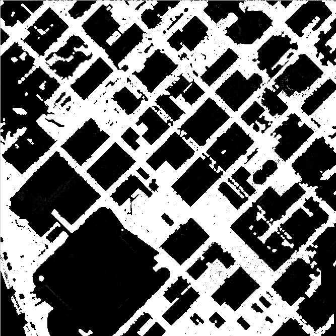
23 5. Road network comple+on Denver Depth image Intensity image Visual Quality: there are and roads and roads are extracted.


24 5. Road network comple+on Denver Depth image Intensity image Visual Quality: there are 10 ver+cal and 5 horizontal roads. 8 ver+cal and 4 horizontal roads are extracted.


25 5. Road network comple+on Oakland Depth image Intensity image Visual Quality: there are and roads and roads are extracted.


26 5. Road network comple+on Atlanta Depth image Intensity image Visual Quality: there are 7 ver+cal and 6 horizontal roads. 5 ver+cal and 4 horizontal roads are extracted.

27 Ques+ons
Sampling Strategies for Object Classifica6on. Gautam Muralidhar
 Sampling Strategies for Object Classifica6on Gautam Muralidhar Reference papers The Pyramid Match Kernel Grauman and Darrell Approximated Correspondences in High Dimensions Grauman and Darrell Video Google
STA 4273H: Sta-s-cal Machine Learning
 STA 4273H: Sta-s-cal Machine Learning Russ Salakhutdinov Department of Statistics! rsalakhu@utstat.toronto.edu! h0p://www.cs.toronto.edu/~rsalakhu/ Lecture 3 Parametric Distribu>ons We want model the probability
1. ORIENTATIONS OF LINES AND PLANES IN SPACE
 I Main Topics A Defini@ons of points, lines, and planes B Geologic methods for describing lines and planes C AMtude symbols for geologic maps D Reference frames 1 II Defini@ons of points, lines, and planes
CS395T Visual Recogni5on and Search. Gautam S. Muralidhar
 CS395T Visual Recogni5on and Search Gautam S. Muralidhar Today s Theme Unsupervised discovery of images Main mo5va5on behind unsupervised discovery is that supervision is expensive Common tasks include
ML4Bio Lecture #1: Introduc3on. February 24 th, 2016 Quaid Morris
 ML4Bio Lecture #1: Introduc3on February 24 th, 216 Quaid Morris Course goals Prac3cal introduc3on to ML Having a basic grounding in the terminology and important concepts in ML; to permit self- study,
CSCI 599 Class Presenta/on. Zach Levine. Markov Chain Monte Carlo (MCMC) HMM Parameter Es/mates
 HMM Parameter Es/mates") CSCI 599 Class Presenta/on Zach Levine Markov Chain Monte Carlo (MCMC) HMM Parameter Es/mates April 26 th, 2012 Topics Covered in this Presenta2on A (Brief) Review of HMMs HMM Parameter Learning Expecta2on-
CSCI 599 Class Presenta/on Zach Levine Markov Chain Monte Carlo (MCMC) HMM Parameter Es/mates April 26 th, 2012 Topics Covered in this Presenta2on A (Brief) Review of HMMs HMM Parameter Learning Expecta2on-
Manipula0on Algorithms Mo0on Planning. Mo#on Planning I. Katharina Muelling (NREC, Carnegie Mellon University) 1
 1") 16-843 Manipula0on Algorithms Mo0on Planning Mo#on Planning I Katharina Muelling (NREC, Carnegie Mellon University) 1 Configura0on Space Obstacles Star Algorithm Convex robot, transla#on C obs : convex
16-843 Manipula0on Algorithms Mo0on Planning Mo#on Planning I Katharina Muelling (NREC, Carnegie Mellon University) 1 Configura0on Space Obstacles Star Algorithm Convex robot, transla#on C obs : convex
Unit #13 : Integration to Find Areas and Volumes, Volumes of Revolution
 Unit #13 : Integration to Find Areas and Volumes, Volumes of Revolution Goals: Beabletoapplyaslicingapproachtoconstructintegralsforareasandvolumes. Be able to visualize surfaces generated by rotating functions
Improvement of the Edge-based Morphological (EM) method for lidar data filtering
 method for lidar data filtering") International Journal of Remote Sensing Vol. 30, No. 4, 20 February 2009, 1069 1074 Letter Improvement of the Edge-based Morphological (EM) method for lidar data filtering QI CHEN* Department of Geography,
International Journal of Remote Sensing Vol. 30, No. 4, 20 February 2009, 1069 1074 Letter Improvement of the Edge-based Morphological (EM) method for lidar data filtering QI CHEN* Department of Geography,
New Features in TerraScan. Arttu Soininen Software developer Terrasolid Ltd
 New Features in TerraScan Arttu Soininen Software developer Terrasolid Ltd Default Coordinate Setup Default coordinate setup category added to Settings Defines coordinate setup to use if you open a design
Road Network Extraction from Airborne LiDAR Data using Scene Context
 Road Network Extraction from Airborne LiDAR Data using Scene Context Jiaping Zhao Suya You University of Southern California Los Angeles, CA 90089 {jiapingz,suya}@usc.edu Abstract We presented a novel
Decision Trees, Random Forests and Random Ferns. Peter Kovesi
 Decision Trees, Random Forests and Random Ferns Peter Kovesi What do I want to do? Take an image. Iden9fy the dis9nct regions of stuff in the image. Mark the boundaries of these regions. Recognize and
TerraSwarm. A Machine Learning and Op0miza0on Toolkit for the Swarm. Ilge Akkaya, Shuhei Emoto, Edward A. Lee. University of California, Berkeley
 TerraSwarm A Machine Learning and Op0miza0on Toolkit for the Swarm Ilge Akkaya, Shuhei Emoto, Edward A. Lee University of California, Berkeley TerraSwarm Tools Telecon 17 November 2014 Sponsored by the
Clustering Lecture 5: Mixture Model
 Clustering Lecture 5: Mixture Model Jing Gao SUNY Buffalo 1 Outline Basics Motivation, definition, evaluation Methods Partitional Hierarchical Density-based Mixture model Spectral methods Advanced topics
CAP5415-Computer Vision Lecture 13-Support Vector Machines for Computer Vision Applica=ons
 CAP5415-Computer Vision Lecture 13-Support Vector Machines for Computer Vision Applica=ons Guest Lecturer: Dr. Boqing Gong Dr. Ulas Bagci bagci@ucf.edu 1 October 14 Reminders Choose your mini-projects
Machine Learning Crash Course: Part I
 Machine Learning Crash Course: Part I Ariel Kleiner August 21, 2012 Machine learning exists at the intersec
Deformable Part Models
 Deformable Part Models References: Felzenszwalb, Girshick, McAllester and Ramanan, Object Detec@on with Discrimina@vely Trained Part Based Models, PAMI 2010 Code available at hkp://www.cs.berkeley.edu/~rbg/latent/
Cover Page. Abstract ID Paper Title. Automated extraction of linear features from vehicle-borne laser data
 Cover Page Abstract ID 8181 Paper Title Automated extraction of linear features from vehicle-borne laser data Contact Author Email Dinesh Manandhar (author1) dinesh@skl.iis.u-tokyo.ac.jp Phone +81-3-5452-6417
CS 6140: Machine Learning Spring Final Exams. What we learned Final Exams 2/26/16
 Logis@cs CS 6140: Machine Learning Spring 2016 Instructor: Lu Wang College of Computer and Informa@on Science Northeastern University Webpage: www.ccs.neu.edu/home/luwang Email: luwang@ccs.neu.edu Assignment
CS 6140: Machine Learning Spring 2016
 CS 6140: Machine Learning Spring 2016 Instructor: Lu Wang College of Computer and Informa?on Science Northeastern University Webpage: www.ccs.neu.edu/home/luwang Email: luwang@ccs.neu.edu Logis?cs Assignment
Multivariable Calculus
 Multivariable Calculus Chapter 10 Topics in Analytic Geometry (Optional) 1. Inclination of a line p. 5. Circles p. 4 9. Determining Conic Type p. 13. Angle between lines p. 6. Parabolas p. 5 10. Rotation
EE368 Project: Visual Code Marker Detection
 EE368 Project: Visual Code Marker Detection Kahye Song Group Number: 42 Email: kahye@stanford.edu Abstract A visual marker detection algorithm has been implemented and tested with twelve training images.
CS 6140: Machine Learning Spring 2016
 CS 6140: Machine Learning Spring 2016 Instructor: Lu Wang College of Computer and Informa?on Science Northeastern University Webpage: www.ccs.neu.edu/home/luwang Email: luwang@ccs.neu.edu Logis?cs Exam
TerraSwarm. A Machine Learning and Op0miza0on Toolkit for the Swarm. Ilge Akkaya, Shuhei Emoto, Edward A. Lee. University of California, Berkeley
 TerraSwarm A Machine Learning and Op0miza0on Toolkit for the Swarm Ilge Akkaya, Shuhei Emoto, Edward A. Lee University of California, Berkeley TerraSwarm Tools Telecon 17 November 2014 Sponsored by the
AUTOMATIC GENERATION OF DIGITAL BUILDING MODELS FOR COMPLEX STRUCTURES FROM LIDAR DATA
 AUTOMATIC GENERATION OF DIGITAL BUILDING MODELS FOR COMPLEX STRUCTURES FROM LIDAR DATA Changjae Kim a, Ayman Habib a, *, Yu-Chuan Chang a a Geomatics Engineering, University of Calgary, Canada - habib@geomatics.ucalgary.ca,
Machine Learning A W 1sst KU. b) [1 P] Give an example for a probability distributions P (A, B, C) that disproves
![Machine Learning A W 1sst KU. b) [1 P] Give an example for a probability distributions P (A, B, C) that disproves](/thumbs/93/111796408.jpg "Machine Learning A W 1sst KU. b) [1 P] Give an example for a probability distributions P (A, B, C) that disproves") Machine Learning A 708.064 11W 1sst KU Exercises Problems marked with * are optional. 1 Conditional Independence I [2 P] a) [1 P] Give an example for a probability distribution P (A, B, C) that disproves
Machine Learning A 708.064 11W 1sst KU Exercises Problems marked with * are optional. 1 Conditional Independence I [2 P] a) [1 P] Give an example for a probability distribution P (A, B, C) that disproves
Towards Knowledge-Based Extraction of Roads from 1m-resolution Satellite Images
 Towards Knowledge-Based Extraction of Roads from 1m-resolution Satellite Images Hae Yeoun Lee* Wonkyu Park** Heung-Kyu Lee* Tak-gon Kim*** * Dept. of Computer Science, Korea Advanced Institute of Science
Automated Extraction of Buildings from Aerial LiDAR Point Cloud and Digital Imaging Datasets for 3D Cadastre - Preliminary Results
 Automated Extraction of Buildings from Aerial LiDAR Point Cloud and Digital Imaging Datasets for 3D Pankaj Kumar 1*, Alias Abdul Rahman 1 and Gurcan Buyuksalih 2 ¹Department of Geoinformation Universiti
6.801/866. Segmentation and Line Fitting. T. Darrell
 6.801/866 Segmentation and Line Fitting T. Darrell Segmentation and Line Fitting Gestalt grouping Background subtraction K-Means Graph cuts Hough transform Iterative fitting (Next time: Probabilistic segmentation)
Logis&c Regression. Aar$ Singh & Barnabas Poczos. Machine Learning / Jan 28, 2014
 Logis&c Regression Aar$ Singh & Barnabas Poczos Machine Learning 10-701/15-781 Jan 28, 2014 Linear Regression & Linear Classifica&on Weight Height Linear fit Linear decision boundary 2 Naïve Bayes Recap
Graphics Hardware and Display Devices
 Graphics Hardware and Display Devices CSE328 Lectures Graphics/Visualization Hardware Many graphics/visualization algorithms can be implemented efficiently and inexpensively in hardware Facilitates interactive
Unit 12 Topics in Analytic Geometry - Classwork
 Unit 1 Topics in Analytic Geometry - Classwork Back in Unit 7, we delved into the algebra and geometry of lines. We showed that lines can be written in several forms: a) the general form: Ax + By + C =
Broadband Pla+orm Valida/on Exercise for Pseudo- Spectral Accelera/on: Review Panel Summary
 Broadband Pla+orm Valida/on Exercise for Pseudo- Spectral Accelera/on: Review Panel Summary Douglas Dreger (UCB) Review Panel Gregory Beroza Steven Day Douglas Dreger (Chair) Chris/ne Goulet Thomas Jordan
Objec&ve % U&lize appropriate tools and methods to produce digital graphics.
 Objec&ve 102.04 20% U&lize appropriate tools and methods to produce digital graphics. Free Transform q Change by using rotate, scale, skew, distort, or perspec&ve in one con&nuous opera&on. Instead of
Segmentation and Modeling of the Spinal Cord for Reality-based Surgical Simulator
 Segmentation and Modeling of the Spinal Cord for Reality-based Surgical Simulator Li X.C.,, Chui C. K.,, and Ong S. H.,* Dept. of Electrical and Computer Engineering Dept. of Mechanical Engineering, National
Topic 5: Raster and Vector Data Models
 Geography 38/42:286 GIS 1 Topic 5: Raster and Vector Data Models Chapters 3 & 4: Chang (Chapter 4: DeMers) 1 The Nature of Geographic Data Most features or phenomena occur as either: discrete entities
BUILDING DETECTION AND STRUCTURE LINE EXTRACTION FROM AIRBORNE LIDAR DATA
 BUILDING DETECTION AND STRUCTURE LINE EXTRACTION FROM AIRBORNE LIDAR DATA C. K. Wang a,, P.H. Hsu a, * a Dept. of Geomatics, National Cheng Kung University, No.1, University Road, Tainan 701, Taiwan. China-
Name. Center axis. Introduction to Conic Sections
 Name Introduction to Conic Sections Center axis This introduction to conic sections is going to focus on what they some of the skills needed to work with their equations and graphs. year, we will only
Edge Detection. CS664 Computer Vision. 3. Edges. Several Causes of Edges. Detecting Edges. Finite Differences. The Gradient
 Edge Detection CS664 Computer Vision. Edges Convert a gray or color image into set of curves Represented as binary image Capture properties of shapes Dan Huttenlocher Several Causes of Edges Sudden changes
EDGE EXTRACTION ALGORITHM BASED ON LINEAR PERCEPTION ENHANCEMENT
 EDGE EXTRACTION ALGORITHM BASED ON LINEAR PERCEPTION ENHANCEMENT Fan ZHANG*, Xianfeng HUANG, Xiaoguang CHENG, Deren LI State Key Laboratory of Information Engineering in Surveying, Mapping and Remote Sensing,
Objec&ve % U&lize appropriate tools and methods to produce digital graphics.
 Objec&ve 102.04 20% U&lize appropriate tools and methods to produce digital graphics. Fill and Stroke q Stroke is the outline of a shape, text or image. Weight Color Style q Fill is the inside color of
Mul$-objec$ve Visual Odometry Hsiang-Jen (Johnny) Chien and Reinhard Kle=e
 Chien and Reinhard Kle=e") Mul$-objec$ve Visual Odometry Hsiang-Jen (Johnny) Chien and Reinhard Kle=e Centre for Robo+cs & Vision Dept. of Electronic and Electric Engineering School of Engineering, Computer, and Mathema+cal Sciences
Mul$-objec$ve Visual Odometry Hsiang-Jen (Johnny) Chien and Reinhard Kle=e Centre for Robo+cs & Vision Dept. of Electronic and Electric Engineering School of Engineering, Computer, and Mathema+cal Sciences
cse 252c Fall 2004 Project Report: A Model of Perpendicular Texture for Determining Surface Geometry
 cse 252c Fall 2004 Project Report: A Model of Perpendicular Texture for Determining Surface Geometry Steven Scher December 2, 2004 Steven Scher SteveScher@alumni.princeton.edu Abstract Three-dimensional
Combining Top-down and Bottom-up Segmentation
 Combining Top-down and Bottom-up Segmentation Authors: Eran Borenstein, Eitan Sharon, Shimon Ullman Presenter: Collin McCarthy Introduction Goal Separate object from background Problems Inaccuracies Top-down
3D Digital Design. SketchUp
 3D Digital Design SketchUp 1 Overview of 3D Digital Design Skills A few basic skills in a design program will go a long way: 1. Orien
REPORT DOCUMENTATION PAGE
 REPORT DOCUMENTATION PAGE Form Approved OMB NO. 0704-0188 The public reporting burden for this collection of information is estimated to average 1 hour per response, including the time for reviewing instructions,
Object Classification Using Tripod Operators
 Object Classification Using Tripod Operators David Bonanno, Frank Pipitone, G. Charmaine Gilbreath, Kristen Nock, Carlos A. Font, and Chadwick T. Hawley US Naval Research Laboratory, 4555 Overlook Ave.
EECS490: Digital Image Processing. Lecture #23
 Lecture #23 Motion segmentation & motion tracking Boundary tracking Chain codes Minimum perimeter polygons Signatures Motion Segmentation P k Accumulative Difference Image Positive ADI Negative ADI (ADI)
10-701/15-781, Fall 2006, Final
 -7/-78, Fall 6, Final Dec, :pm-8:pm There are 9 questions in this exam ( pages including this cover sheet). If you need more room to work out your answer to a question, use the back of the page and clearly
Area and Volume. where x right and x left are written in terms of y.
 Area and Volume Area between two curves Sketch the region and determine the points of intersection. Draw a small strip either as dx or dy slicing. Use the following templates to set up a definite integral:
Minimum Redundancy and Maximum Relevance Feature Selec4on. Hang Xiao
 Minimum Redundancy and Maximum Relevance Feature Selec4on Hang Xiao Background Feature a feature is an individual measurable heuris4c property of a phenomenon being observed In character recogni4on: horizontal
A Smartphone Based Real Time Ac5vity Monitoring System
 A Smartphone Based Real Time Ac5vity Monitoring System By: Shumei Zhang, Paul McCullagh, Jing Zhang, Tiezhong Yu Presented by: Jane Henderson A Smartphone Based-Real Time Daily Ac5vity Monitoring System
Lecture 9: Hough Transform and Thresholding base Segmentation
 #1 Lecture 9: Hough Transform and Thresholding base Segmentation Saad Bedros sbedros@umn.edu Hough Transform Robust method to find a shape in an image Shape can be described in parametric form A voting
Research on-board LIDAR point cloud data pretreatment
 Acta Technica 62, No. 3B/2017, 1 16 c 2017 Institute of Thermomechanics CAS, v.v.i. Research on-board LIDAR point cloud data pretreatment Peng Cang 1, Zhenglin Yu 1, Bo Yu 2, 3 Abstract. In view of the
FAST REGISTRATION OF TERRESTRIAL LIDAR POINT CLOUD AND SEQUENCE IMAGES
 FAST REGISTRATION OF TERRESTRIAL LIDAR POINT CLOUD AND SEQUENCE IMAGES Jie Shao a, Wuming Zhang a, Yaqiao Zhu b, Aojie Shen a a State Key Laboratory of Remote Sensing Science, Institute of Remote Sensing
INTEGRATION OF TREE DATABASE DERIVED FROM SATELLITE IMAGERY AND LIDAR POINT CLOUD DATA
 INTEGRATION OF TREE DATABASE DERIVED FROM SATELLITE IMAGERY AND LIDAR POINT CLOUD DATA S. C. Liew 1, X. Huang 1, E. S. Lin 2, C. Shi 1, A. T. K. Yee 2, A. Tandon 2 1 Centre for Remote Imaging, Sensing
Final Exam Assigned: 11/21/02 Due: 12/05/02 at 2:30pm
 6.801/6.866 Machine Vision Final Exam Assigned: 11/21/02 Due: 12/05/02 at 2:30pm Problem 1 Line Fitting through Segmentation (Matlab) a) Write a Matlab function to generate noisy line segment data with
AUTOMATIC EXTRACTION OF ROAD MARKINGS FROM MOBILE LASER SCANNING DATA
 AUTOMATIC EXTRACTION OF ROAD MARKINGS FROM MOBILE LASER SCANNING DATA Hao Ma a,b, Zhihui Pei c, Zhanying Wei a,b,*, Ruofei Zhong a a Beijing Advanced Innovation Center for Imaging Technology, Capital Normal
Presented at the FIG Congress 2018, May 6-11, 2018 in Istanbul, Turkey
 Presented at the FIG Congress 2018, May 6-11, 2018 in Istanbul, Turkey Evangelos MALTEZOS, Charalabos IOANNIDIS, Anastasios DOULAMIS and Nikolaos DOULAMIS Laboratory of Photogrammetry, School of Rural
Equation to LaTeX. Abhinav Rastogi, Sevy Harris. I. Introduction. Segmentation.
 Equation to LaTeX Abhinav Rastogi, Sevy Harris {arastogi,sharris5}@stanford.edu I. Introduction Copying equations from a pdf file to a LaTeX document can be time consuming because there is no easy way
Privacy-Preserving Shortest Path Computa6on
 Privacy-Preserving Shortest Path Computa6on David J. Wu, Joe Zimmerman, Jérémy Planul, and John C. Mitchell Stanford University Naviga6on desired des@na@on current posi@on Naviga6on: A Solved Problem?
TIDAL CHANNEL IDENTIFICATION FROM REMOTELY SENSED DATA USING SPECTRAL AND SHAPE CHARACTERISTICS
 TIDAL CHANNEL IDENTIFICATION FROM REMOTELY SENSED DATA USING SPECTRAL AND SHAPE CHARACTERISTICS Bharat Lohani a, *, B. Sreenivas a a Department of Civil Engineering, IIT Kanpur, Kanpur 0806 (India)- blohani@iitk.ac.in
On the Selection of an Interpolation Method for Creating a Terrain Model (TM) from LIDAR Data
 from LIDAR Data") On the Selection of an Interpolation Method for Creating a Terrain Model (TM) from LIDAR Data Tarig A. Ali Department of Technology and Geomatics East Tennessee State University P. O. Box 70552, Johnson
On the Selection of an Interpolation Method for Creating a Terrain Model (TM) from LIDAR Data Tarig A. Ali Department of Technology and Geomatics East Tennessee State University P. O. Box 70552, Johnson
Fast Sample Generation with Variational Bayesian for Limited Data Hyperspectral Image Classification
 Fast Sample Generation with Variational Bayesian for Limited Data Hyperspectral Image Classification July 26, 2018 AmirAbbas Davari, Hasan Can Özkan, Andreas Maier, Christian Riess Pattern Recognition
Motion Tracking and Event Understanding in Video Sequences
 Motion Tracking and Event Understanding in Video Sequences Isaac Cohen Elaine Kang, Jinman Kang Institute for Robotics and Intelligent Systems University of Southern California Los Angeles, CA Objectives!
AN EFFICIENT METHOD FOR AUTOMATIC ROAD EXTRACTION BASED ON MULTIPLE FEATURES FROM LiDAR DATA
 AN EFFICIENT METHOD FOR AUTOMATIC ROAD EXTRACTION BASED ON MULTIPLE FEATURES FROM LiDAR DATA Y. Li a, X. Hu b, H. Guan c, P. Liu d a School of Civil Engineering and Architecture, Nanchang University, 330031,
Stereo imaging ideal geometry
 Stereo imaging ideal geometry (X,Y,Z) Z f (x L,y L ) f (x R,y R ) Optical axes are parallel Optical axes separated by baseline, b. Line connecting lens centers is perpendicular to the optical axis, and
Search Engines. Informa1on Retrieval in Prac1ce. Annota1ons by Michael L. Nelson
 Search Engines Informa1on Retrieval in Prac1ce Annota1ons by Michael L. Nelson All slides Addison Wesley, 2008 Evalua1on Evalua1on is key to building effec$ve and efficient search engines measurement usually
Digital Image Processing Fundamentals
 Ioannis Pitas Digital Image Processing Fundamentals Chapter 7 Shape Description Answers to the Chapter Questions Thessaloniki 1998 Chapter 7: Shape description 7.1 Introduction 1. Why is invariance to
Today s Class. High Dimensional Data & Dimensionality Reduc8on. Readings for This Week: Today s Class. Scien8fic Data. Misc. Personal Data 2/22/12
 High Dimensional Data & Dimensionality Reduc8on Readings for This Week: Graphical Histories for Visualiza8on: Suppor8ng Analysis, Communica8on, and Evalua8on, Jeffrey Heer, Jock D. Mackinlay, Chris Stolte,
Learning and Inferring Depth from Monocular Images. Jiyan Pan April 1, 2009
 Learning and Inferring Depth from Monocular Images Jiyan Pan April 1, 2009 Traditional ways of inferring depth Binocular disparity Structure from motion Defocus Given a single monocular image, how to infer
Chapter 3 Image Registration. Chapter 3 Image Registration
 Chapter 3 Image Registration Distributed Algorithms for Introduction (1) Definition: Image Registration Input: 2 images of the same scene but taken from different perspectives Goal: Identify transformation
REGION BASED SEGEMENTATION
 REGION BASED SEGEMENTATION The objective of Segmentation is to partition an image into regions. The region-based segmentation techniques find the regions directly. Extract those regions in the image whose
6. Applications - Text recognition in videos - Semantic video analysis
 6. Applications - Text recognition in videos - Semantic video analysis Stephan Kopf 1 Motivation Goal: Segmentation and classification of characters Only few significant features are visible in these simple
Module 6: Pinhole camera model Lecture 32: Coordinate system conversion, Changing the image/world coordinate system
 The Lecture Contains: Back-projection of a 2D point to 3D 6.3 Coordinate system conversion file:///d /...(Ganesh%20Rana)/MY%20COURSE_Ganesh%20Rana/Prof.%20Sumana%20Gupta/FINAL%20DVSP/lecture%2032/32_1.htm[12/31/2015
Geometric and Algebraic Connections
 Geometric and Algebraic Connections Geometric and Algebraic Connections Triangles, circles, rectangles, squares... We see shapes every day, but do we know much about them?? What characteristics do they
Learning and Recognizing Visual Object Categories Without First Detecting Features
 Learning and Recognizing Visual Object Categories Without First Detecting Features Daniel Huttenlocher 2007 Joint work with D. Crandall and P. Felzenszwalb Object Category Recognition Generic classes rather
Lab 2. Decision (Classification) Tree
 Tree") Lab 2. Decision (Classification) Tree Represented as a set of hierarchically-arranged decision rules (i.e., tree-branch-leaf) Could be generated by knowledge engineering, neural network, or statistic methods.
Lab 2. Decision (Classification) Tree Represented as a set of hierarchically-arranged decision rules (i.e., tree-branch-leaf) Could be generated by knowledge engineering, neural network, or statistic methods.
CRF Based Point Cloud Segmentation Jonathan Nation
 CRF Based Point Cloud Segmentation Jonathan Nation jsnation@stanford.edu 1. INTRODUCTION The goal of the project is to use the recently proposed fully connected conditional random field (CRF) model to
Adaptive Learning of an Accurate Skin-Color Model
 Adaptive Learning of an Accurate Skin-Color Model Q. Zhu K.T. Cheng C. T. Wu Y. L. Wu Electrical & Computer Engineering University of California, Santa Barbara Presented by: H.T Wang Outline Generic Skin
ELEN E4830 Digital Image Processing. Homework 6 Solution
 ELEN E4830 Digital Image Processing Homework 6 Solution Chuxiang Li cxli@ee.columbia.edu Department of Electrical Engineering, Columbia University April 10, 2006 1 Edge Detection 1.1 Sobel Operator The
The Curse of Dimensionality
 The Curse of Dimensionality ACAS 2002 p1/66 Curse of Dimensionality The basic idea of the curse of dimensionality is that high dimensional data is difficult to work with for several reasons: Adding more
DIGITAL SURFACE MODELS OF CITY AREAS BY VERY HIGH RESOLUTION SPACE IMAGERY
 DIGITAL SURFACE MODELS OF CITY AREAS BY VERY HIGH RESOLUTION SPACE IMAGERY Jacobsen, K. University of Hannover, Institute of Photogrammetry and Geoinformation, Nienburger Str.1, D30167 Hannover phone +49
COMPARATIVE STUDY OF DIFFERENT APPROACHES FOR EFFICIENT RECTIFICATION UNDER GENERAL MOTION
 COMPARATIVE STUDY OF DIFFERENT APPROACHES FOR EFFICIENT RECTIFICATION UNDER GENERAL MOTION Mr.V.SRINIVASA RAO 1 Prof.A.SATYA KALYAN 2 DEPARTMENT OF COMPUTER SCIENCE AND ENGINEERING PRASAD V POTLURI SIDDHARTHA
COORDINATE TRANSFORMATION. Lecture 6
 COORDINATE TRANSFORMATION Lecture 6 SGU 1053 SURVEY COMPUTATION 1 Introduction Geomatic professional are mostly confronted in their work with transformations from one two/three-dimensional coordinate system
Math 8 Review Package
 UNIVERSITY HILL SECONDARY SCHOOL Math 8 Review Package Chapter 8 Math 8 Blk: F Timmy Harrison Jan 2013/6/7 This is a unit review package of chapter 8 in Theory and Problems for Mathematics 8 This review
Spa$al Analysis and Modeling (GIST 4302/5302) Guofeng Cao Department of Geosciences Texas Tech University
 Guofeng Cao Department of Geosciences Texas Tech University") Spa$al Analysis and Modeling (GIST 432/532) Guofeng Cao Department of Geosciences Texas Tech University Representa$on of Spa$al Data Representa$on of Spa$al Data Models Object- based model: treats the
Spa$al Analysis and Modeling (GIST 432/532) Guofeng Cao Department of Geosciences Texas Tech University Representa$on of Spa$al Data Representa$on of Spa$al Data Models Object- based model: treats the
Chapter 9 Topics in Analytic Geometry
 Chapter 9 Topics in Analytic Geometry What You ll Learn: 9.1 Introduction to Conics: Parabolas 9.2 Ellipses 9.3 Hyperbolas 9.5 Parametric Equations 9.6 Polar Coordinates 9.7 Graphs of Polar Equations 9.1
HS Geometry Mathematics CC
 Course Description This course involves the integration of logical reasoning and spatial visualization skills. It includes a study of deductive proofs and applications from Algebra, an intense study of
Correlation of the ALEKS courses Algebra 1 and High School Geometry to the Wyoming Mathematics Content Standards for Grade 11
 Correlation of the ALEKS courses Algebra 1 and High School Geometry to the Wyoming Mathematics Content Standards for Grade 11 1: Number Operations and Concepts Students use numbers, number sense, and number
Terrestrial Laser Scanning: Applications in Civil Engineering Pauline Miller
 Terrestrial Laser Scanning: Applications in Civil Engineering Pauline Miller School of Civil Engineering & Geosciences Newcastle University Overview Laser scanning overview Research applications geometric
MATHEMATICS (SYLLABUS D) 4024/02
 4024/02") CAMBRIDGE INTERNATIONAL EXAMINATIONS General Certificate of Education Ordinary Level MATHEMATICS (SYLLABUS D) 4024/02 Paper 2 Additional Materials: Answer Booklet/Paper Electronic calculator Geometrical
CAMBRIDGE INTERNATIONAL EXAMINATIONS General Certificate of Education Ordinary Level MATHEMATICS (SYLLABUS D) 4024/02 Paper 2 Additional Materials: Answer Booklet/Paper Electronic calculator Geometrical
UTILIZACIÓN DE DATOS LIDAR Y SU INTEGRACIÓN CON SISTEMAS DE INFORMACIÓN GEOGRÁFICA
 UTILIZACIÓN DE DATOS LIDAR Y SU INTEGRACIÓN CON SISTEMAS DE INFORMACIÓN GEOGRÁFICA Aurelio Castro Cesar Piovanetti Geographic Mapping Technologies Corp. (GMT) Consultores en GIS info@gmtgis.com Geographic
Basic relations between pixels (Chapter 2)
") Basic relations between pixels (Chapter 2) Lecture 3 Basic Relationships Between Pixels Definitions: f(x,y): digital image Pixels: q, p (p,q f) A subset of pixels of f(x,y): S A typology of relations:
Basic relations between pixels (Chapter 2) Lecture 3 Basic Relationships Between Pixels Definitions: f(x,y): digital image Pixels: q, p (p,q f) A subset of pixels of f(x,y): S A typology of relations:
Rethinking Road Planning and Design Workflows:
 Rethinking Road Planning and Design Workflows: Unlocking the Potential of LiDAR Craig Speirs Softree Technical Systems Forest road construction is one of the most expensive components of timber harvesting.
SUPPLEMENTARY FILE S1: 3D AIRWAY TUBE RECONSTRUCTION AND CELL-BASED MECHANICAL MODEL. RELATED TO FIGURE 1, FIGURE 7, AND STAR METHODS.
 SUPPLEMENTARY FILE S1: 3D AIRWAY TUBE RECONSTRUCTION AND CELL-BASED MECHANICAL MODEL. RELATED TO FIGURE 1, FIGURE 7, AND STAR METHODS. 1. 3D AIRWAY TUBE RECONSTRUCTION. RELATED TO FIGURE 1 AND STAR METHODS
The Prac)cal Applica)on of Knowledge Discovery to Image Data: A Prac))oners View in The Context of Medical Image Mining
cal Applica)on of Knowledge Discovery to Image Data: A Prac))oners View in The Context of Medical Image Mining") The Prac)cal Applica)on of Knowledge Discovery to Image Data: A Prac))oners View in The Context of Medical Image Mining Frans Coenen (http://cgi.csc.liv.ac.uk/~frans/) 10th Interna+onal Conference on Natural
The Prac)cal Applica)on of Knowledge Discovery to Image Data: A Prac))oners View in The Context of Medical Image Mining Frans Coenen (http://cgi.csc.liv.ac.uk/~frans/) 10th Interna+onal Conference on Natural
Energy- Aware Time Change Detec4on Using Synthe4c Aperture Radar On High- Performance Heterogeneous Architectures: A DDDAS Approach
 Energy- Aware Time Change Detec4on Using Synthe4c Aperture Radar On High- Performance Heterogeneous Architectures: A DDDAS Approach Sanjay Ranka (PI) Sartaj Sahni (Co- PI) Mark Schmalz (Co- PI) University
HEURISTIC FILTERING AND 3D FEATURE EXTRACTION FROM LIDAR DATA
 HEURISTIC FILTERING AND 3D FEATURE EXTRACTION FROM LIDAR DATA Abdullatif Alharthy, James Bethel School of Civil Engineering, Purdue University, 1284 Civil Engineering Building, West Lafayette, IN 47907
VOCABULARY. Chapters 1, 2, 3, 4, 5, 9, and 8. WORD IMAGE DEFINITION An angle with measure between 0 and A triangle with three acute angles.
 Acute VOCABULARY Chapters 1, 2, 3, 4, 5, 9, and 8 WORD IMAGE DEFINITION Acute angle An angle with measure between 0 and 90 56 60 70 50 A with three acute. Adjacent Alternate interior Altitude of a Angle