Getting Out of Squaresville: MODFLOW USG Tools for ArcGIS Steven E. Silver, GISP
|
|
|
- Tyler Dickerson
- 5 years ago
- Views:
Transcription

1 Getting Out of Squaresville: MODFLOW USG Tools for ArcGIS Steven E. Silver, GISP ESRI 2014 Users Conference BALLEAU GROUNDWATER, INC.


2 Why Use ArcGIS for Hydrologic Modeling? 1) Access map-base and data
 Flexibility to meet new classes of problems Use well known MODFLOW")

3 Why Use ArcGIS for Hydrologic Modeling? 2) Flexibility to meet new classes of problems Use well known MODFLOW input output patterns and model concepts and flexibly apply geo-spatialy aware scripting tools to achieve novel analysis and visualizations of hydrologic model and related data.

4 Why Use ArcGIS for Hydrologic Modeling? 3) Results look like Hydrogeology.
, was developed to support a wide variety of structured and unstructured grid types, including nested grids and grids based on")
5 What is MODFLOW-USG? A new version of MODFLOW, called MODFLOW USG (for UnStructured Grid), was developed to support a wide variety of structured and unstructured grid types, including nested grids and grids based on prismatic triangles, rectangles, hexagons, and other cell shapes. Flexibility in grid design can be used to focus resolution along rivers and around wells, for example, or to subdiscretize individual layers to better represent hydrostratigraphic units.


6 Background: Finite Element Models in ArcGIS


7 Background: Integrated Finite Difference in MODFLOW-88 and ArcGIS Romero, D.M., and Silver S.E., 2006, Grid cell distortion and MODFLOW s integrated finitedifference numerical solution: Ground Water v. 44, p


8 Implementation: Toolset and Schema


9 Implementation: Code (ArcPy + Python)
10 Implementation: Use
11 Grids and Meshes The term unstructured grid simply means that the number of connections may be variable for each cell. For example, with mesh-centered triangular finite-elements, a node may be common to several elements, and this connectivity may vary for each node. This variability results in an unstructured system of equations. Similarly, in CVFD schemes the connectivity of a cell depends on the number of shared faces, which may vary for each cell. USGS Techniques and Methods 6 A45 pg. 8

12 Grids and Meshes: Tools

13 Grids and Meshes: Tools Mesh tool utilizes Gmsh: C. Geuzaine and J.-F. Remacle. Gmsh: a threedimensional finite element mesh generator with built-in pre- and post-processing facilities. International Journal for Numerical Methods in Engineering 79(11), pp , 2009


14 Grids and Meshes: Refinement and Boundary
15 Grids and Meshes: Grid
16 Grids and Meshes: Grid with Irregular Domain

17 Grids and Meshes: Grid with Quad-Tree Refinement
18 Grids and Meshes: Grid with Sub-Grids

19 Grids and Meshes: Triangular Mesh

20 Grids and Meshes: Quadrilateral Mesh
21 Grids and Meshes: Triangular Mesh With Embedded Polyline

22 Grids and Meshes: Quadrilateral Mesh With Attractor

23 Grids and Meshes: Quadrilateral Transfinite Mesh

24 Geo-Cellular Model
25 Geo-Cellular Model

26 Geo-Cellular Model

27 Building Grid Topology: Lateral Connections BALLEAU GROUNDWATER, INC


28 Building Grid Topology: Lateral Connections BALLEAU GROUNDWATER, INC

29 Building Grid Topology: Lateral Connections
, no connection to layer 3.")
 Lateral Connections by layer, flow area")
30 Building Grid Topology: Lateral Connections Layers 10,11 and 12 connect to layer 3 Layers 12 ends (pinches out), no connection to layer 3. Layer 3 Layer 10 Layer 11 Layer 12 Layer 3 Layer 12 1) Lateral Connections and flow area by geometric intersection 2) Lateral Connections by layer, flow area by layer geometry
 Write constant head package 8) Write RIV1 and ET packages 9) Create polygon FC from geo-cells 10) Create cross section 11) Read MF-USG solution head file and create water-table grid and")
31 Interaction with MODFLOW-USG 1) Write discretization package arrays 2) Write LPF/UPW arrays 3) Write starting head 4) Return number of cell in each layer 5) Return top most active cells 6) Return edge cells 7) Write constant head package 8) Write RIV1 and ET packages 9) Create polygon FC from geo-cells 10) Create cross section 11) Read MF-USG solution head file and create water-table grid and saturated outcrop.

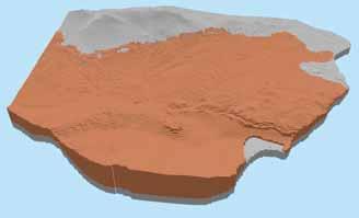
32 Example


33 Example

34 Example
35 Example
 Ghost Node Placement and Calculation 2) Connected")
36 Next Steps? 1) Ghost Node Placement and Calculation 2) Connected Linear Network Support 3) Transient stress packages
MODFLOW-USG Complex Stratigraphy Create a MODFLOW-USG model of a site with complex 3D stratigraphy using GMS
 v. 10.1 GMS 10.1 Tutorial MODFLOW-USG Complex Stratigraphy Create a MODFLOW-USG model of a site with complex 3D stratigraphy using GMS Objectives GMS supports building MODFLOW-USG models with multiple
Groundwater in Hydrologic Cycle
 Groundwater in Hydrologic Cycle Types of Terrestrial Water Surface Water Soil Moisture Ground water Pores Full of Combination of Air and Water Unsaturated Zone / Zone of Aeration / Vadose (Soil Water)
The General Purpose Parameter Based Two Dimensional Mesh Generator
 The General Purpose Parameter Based Two Dimensional Mesh Generator Abstract Sivamayam Sivasuthan Department of Electrical and Computer Engineering Michigan State University East Lansing, MI 48824, USA
Tutorial: MODFLOW-USG Tutorial
 Tutorial: Visual MODFLOW Flex 5.0 Integrated Conceptual & Numerical Groundwater Modeling Software 1 1 Visual MODFLOW Flex 5.0 The following example is a walk through of creating a MODFLOW-USG groundwater
Tutorial: Conceptual Modeling Tutorial. Integrated Conceptual & Numerical Groundwater Modeling Software by Waterloo Hydrogeologic
 Tutorial: Visual MODFLOW Flex 5.1 Integrated Conceptual & Numerical Groundwater Modeling Software 1 1 Visual MODFLOW Flex 5.1 The following example is a quick walk-through of the basics of building a conceptual
A Semi-Analytical Particle Tracking Algorithm for Arbitrary Unstructured Grids
 A Semi-Analytical Particle Tracking Algorithm for Arbitrary Unstructured Grids by Muhammad Ramadhan A thesis presented to the University of Waterloo in fulfillment of the thesis requirement for the degree
Topological Issues in Hexahedral Meshing
 Topological Issues in Hexahedral Meshing David Eppstein Univ. of California, Irvine Dept. of Information and Computer Science Outline I. What is meshing? Problem statement Types of mesh Quality issues
Data Representation in Visualisation
 Data Representation in Visualisation Visualisation Lecture 4 Taku Komura Institute for Perception, Action & Behaviour School of Informatics Taku Komura Data Representation 1 Data Representation We have
ARC HYDRO GROUNDWATER TUTORIALS
 ARC HYDRO GROUNDWATER TUTORIALS Working with MODFLOW Models Steady State Arc Hydro Groundwater (AHGW) is a geodatabase design for representing groundwater datasets within ArcGIS. The data model helps to
Saab. Kyle McDonald. Polygon Meshes
 Saab Kyle McDonald Polygon Meshes Siddhartha Chaudhuri http://www.cse.iitb.ac.in/~cs749 What is a polygon mesh? Like a point cloud, it is a discrete sampling of a surface... but, it adds linear (flat)
3.1 Conceptual Modeling
 Quick Start Tutorials 35 3.1 Conceptual Modeling Conceptual Modeling Tutorial The following example is a quick walk through of the basics of building a conceptual model and converting this to a numerical
GMS 10.0 Tutorial MODFLOW Conceptual Model Approach II Build a multi-layer MODFLOW model using advanced conceptual model techniques
 v. 10.0 GMS 10.0 Tutorial Build a multi-layer MODFLOW model using advanced conceptual model techniques 00 Objectives The conceptual model approach involves using the GIS tools in the Map Module to develop
MODFLOW Conceptual Model Approach II Build a multi-layer MODFLOW model using advanced conceptual model techniques
 v. 10.2 GMS 10.2 Tutorial Build a multi-layer MODFLOW model using advanced conceptual model techniques 00 Objectives The conceptual model approach involves using the GIS tools in the Map module to develop
Meshing of flow and heat transfer problems
 Meshing of flow and heat transfer problems Luyao Zou a, Zhe Li b, Qiqi Fu c and Lujie Sun d School of, Shandong University of science and technology, Shandong 266590, China. a zouluyaoxf@163.com, b 1214164853@qq.com,
MODFLOW Regional to Local Model Conversion,
 v. 10.2 GMS 10.2 Tutorial MODFLOW Regional to Local Model Conversion, Steady State Create a local model from a regional model using convenient tools provided in GMS Objectives Use the convenient tools
GMS 9.1 Tutorial MODFLOW Conceptual Model Approach II Build a multi-layer MODFLOW model using advanced conceptual model techniques
 v. 9.1 GMS 9.1 Tutorial Build a multi-layer MODFLOW model using advanced conceptual model techniques 00 Objectives The conceptual model approach involves using the GIS tools in the Map module to develop
Geometry Vocabulary. acute angle-an angle measuring less than 90 degrees
 Geometry Vocabulary acute angle-an angle measuring less than 90 degrees angle-the turn or bend between two intersecting lines, line segments, rays, or planes angle bisector-an angle bisector is a ray that
Conceptual Approach to Groundwater Modeling A New Generation of Waterloo Hydrogeologic Software
 Conceptual Approach to Groundwater Modeling A New Generation of Waterloo Hydrogeologic Software Serguei Chmakov 1, Petr Sychev 2, Wayne Hesch 1, Collin Tu1, Marconi Lima 3, 1 Schlumberger Water Services,
MODFLOW - Conceptual Model Approach
 GMS 7.0 TUTORIALS MODFLOW - Conceptual Model Approach 1 Introduction Two approaches can be used to construct a MODFLOW simulation in GMS: the grid approach or the conceptual model approach. The grid approach
OpenACC Based GPU Parallelization of Plane Sweep Algorithm for Geometric Intersection. Anmol Paudel Satish Puri Marquette University Milwaukee, WI
 OpenACC Based GPU Parallelization of Plane Sweep Algorithm for Geometric Intersection Anmol Paudel Satish Puri Marquette University Milwaukee, WI Introduction Scalable spatial computation on high performance
Cartographic Techniques and Representations
 Cartographic Techniques and Representations NEARC 2007 ESRI Technical Session ESRI, Boston Overview of Presentation Labeling and Annotation Masking Layout Tips Cartographic Representations Labeling versus
Femap Version
 Femap Version 11.3 Benefits Easier model viewing and handling Faster connection definition and setup Faster and easier mesh refinement process More accurate meshes with minimal triangle element creation
Structured Grid Generation for Turbo Machinery Applications using Topology Templates
 Structured Grid Generation for Turbo Machinery Applications using Topology Templates January 13th 2011 Martin Spel martin.spel@rtech.fr page 1 Agenda: R.Tech activities Grid Generation Techniques Structured
Gmsh GUI Tutorial I: How to Create a Simple 2D Model?
 Gmsh GUI Tutorial I: How to Create a Simple 2D Model? Christophe Geuzaine and Jean-François Remacle January 4, 2006 http://geuz.org/gmsh/doc/gui_tutorial/ This tutorial shows all the steps involved in
An Efficient Paving Method of Pure Quad Mesh Generation
 2016 International Conference on Intelligent Manufacturing and Materials (ICIMM 2016) ISBN: 978-1-60595-363-2 An Efficient Paving Method of Pure Quad Mesh Generation Yongcai Liu, Wenliang Chen and Yidong
PorePy: A Python Simulation Tool for Fractured and Deformable Porous Media. Eirik Keilegavlen, Alessio Fumagalli, Runar Berge, Ivar Stefansson
 PorePy: A Python Simulation Tool for Fractured and Deformable Porous Media Eirik Keilegavlen, Alessio Fumagalli, Runar Berge, Ivar Stefansson Summary Meshing and discretization of dynamics in fractured
APPLICATION OF ALGORITHMS FOR AUTOMATIC GENERATION OF HEXAHEDRAL FINITE ELEMENT MESHES
 MESTRADO EM ENGENHARIA MECÂNICA November 2014 APPLICATION OF ALGORITHMS FOR AUTOMATIC GENERATION OF HEXAHEDRAL FINITE ELEMENT MESHES Luís Miguel Rodrigues Reis Abstract. The accuracy of a finite element
A new multidimensional-type reconstruction and limiting procedure for unstructured (cell-centered) FVs solving hyperbolic conservation laws
 FVs solving hyperbolic conservation laws") HYP 2012, Padova A new multidimensional-type reconstruction and limiting procedure for unstructured (cell-centered) FVs solving hyperbolic conservation laws Argiris I. Delis & Ioannis K. Nikolos (TUC)
HYP 2012, Padova A new multidimensional-type reconstruction and limiting procedure for unstructured (cell-centered) FVs solving hyperbolic conservation laws Argiris I. Delis & Ioannis K. Nikolos (TUC)
Anoka Hennepin K-12 Curriculum plan
 Anoka Hennepin K-12 Curriculum plan Department: Elementary Math Unit Title: Packages and Polygons (Blue Book, Geo and Measurement) Triangles and Beyond (Blue Book, Geo and Measurement) Everyday Math: Volume
v SMS 11.1 Tutorial SRH-2D Prerequisites None Time minutes Requirements Map Module Mesh Module Scatter Module Generic Model SRH-2D
 v. 11.1 SMS 11.1 Tutorial SRH-2D Objectives This lesson will teach you how to prepare an unstructured mesh, run the SRH-2D numerical engine and view the results all within SMS. You will start by reading
Conceptual Model Development for FEFLOW or MODFLOW Models A New Generation of Schlumberger Water Services Software
 Conceptual Model Development for FEFLOW or MODFLOW Models A New Generation of Schlumberger Water Services Software Serguei Chmakov schmakov@slb.com Wayne Hesch whesch@slb.com Collin Tu xtu@slb.com Marconi
GMS 9.0 Tutorial MODFLOW Conceptual Model Approach II Build a multi-layer MODFLOW model using advanced conceptual model techniques
 v. 9.0 GMS 9.0 Tutorial Build a multi-layer MODFLOW model using advanced conceptual model techniques 00 Objectives The conceptual model approach involves using the GIS tools in the Map module to develop
An Overview of Commonly Used Groundwater Modelling Software
 An Overview of Commonly Used Groundwater Modelling Software C. P. Kumar Scientist G, National Institute of Hydrology, Roorkee 247667, India ABSTRACT: A groundwater model is any computational method that
Integrated 2D Surface-Groundwater Modeling of the Green Swamp, Florida
 Integrated 2D Surface-Groundwater Modeling of the Green Swamp, Florida Peter J. Singhofen, P.E. Gordon L. McClung, P.E Streamline Technologies, Inc. 1900 Town Plaza Ct. Winter Springs, FL 32708 407-679-1696
Geometric Modeling in Graphics
 Geometric Modeling in Graphics Part 10: Surface reconstruction Martin Samuelčík www.sccg.sk/~samuelcik samuelcik@sccg.sk Curve, surface reconstruction Finding compact connected orientable 2-manifold surface
NUMERICAL COUPLING BETWEEN DEM (DISCRETE ELEMENT METHOD) AND FEA (FINITE ELEMENTS ANALYSIS).
 AND FEA (FINITE ELEMENTS ANALYSIS).") NUMERICAL COUPLING BETWEEN DEM (DISCRETE ELEMENT METHOD) AND FEA (FINITE ELEMENTS ANALYSIS). Daniel Schiochet Nasato - ESSS Prof. Dr. José Roberto Nunhez Unicamp Dr. Nicolas Spogis - ESSS Fabiano Nunes
NUMERICAL COUPLING BETWEEN DEM (DISCRETE ELEMENT METHOD) AND FEA (FINITE ELEMENTS ANALYSIS). Daniel Schiochet Nasato - ESSS Prof. Dr. José Roberto Nunhez Unicamp Dr. Nicolas Spogis - ESSS Fabiano Nunes
2.4 Angle Properties in Polygons.notebook. October 27, 2013 ENTRANCE SLIP
 ENTRANCE SLIP If you are given one interior angle and one exterior angle of a triangle, can you always determine the other interior angles of the triangle? Explain, using diagrams. 1 2.4 Angle Properties
A New Smoothing Algorithm for Quadrilateral and Hexahedral Meshes
 A New Smoothing Algorithm for Quadrilateral and Hexahedral Meshes Sanjay Kumar Khattri Department of Mathematics, University of Bergen, Norway sanjay@mi.uib.no http://www.mi.uib.no/ sanjay Abstract. Mesh
Physically-Based Modeling and Animation. University of Missouri at Columbia
 Overview of Geometric Modeling Overview 3D Shape Primitives: Points Vertices. Curves Lines, polylines, curves. Surfaces Triangle meshes, splines, subdivision surfaces, implicit surfaces, particles. Solids
New Engines. The following SEAWAT flow packages are supported in Visual MODFLOW Flex:
 Visual MODFLOW Flex provides vibrant tools and time-saving workflow options, giving you the ability to efficiently build complex groundwater models. Visually stunning projects are at your fingertips with
Scalar Field Visualization I
 Scalar Field Visualization I What is a Scalar Field? The approximation of certain scalar function in space f(x,y,z). Image source: blimpyb.com f What is a Scalar Field? The approximation of certain scalar
Surface Mesh Generation
 Surface Mesh Generation J.-F. Remacle Université catholique de Louvain September 22, 2011 0 3D Model For the description of the mesh generation process, let us consider the CAD model of a propeller presented
HPC Computer Aided CINECA
 HPC Computer Aided Engineering @ CINECA Raffaele Ponzini Ph.D. CINECA SuperComputing Applications and Innovation Department SCAI 16-18 June 2014 Segrate (MI), Italy Outline Open-source CAD and Meshing
The Regular Hierarchical Surface Model (RHSM)
") The Regular Hierarchical Surface Model (RHSM) Joseph W. Wright 1 2, Antoni B. Moore * 1 and Gregory H. Leonard 1 1 School of Surveying, University of Otago, PO Box 56, Dunedin, New Zealand 2 Cardno, Wellington,
The Regular Hierarchical Surface Model (RHSM) Joseph W. Wright 1 2, Antoni B. Moore * 1 and Gregory H. Leonard 1 1 School of Surveying, University of Otago, PO Box 56, Dunedin, New Zealand 2 Cardno, Wellington,
FEMA Floodplain Mapping
 FEMA Floodplain Mapping By Luke Sturtevant Introduction The National Flood Insurance Program (NFIP) has compiled massive databases containing information and maps of floodplains for the entire United States.
Describe Plane Shapes
 Lesson 12.1 Describe Plane Shapes You can use math words to describe plane shapes. point an exact position or location line endpoints line segment ray a straight path that goes in two directions without
Integrated Groundwater Surface Water Modeling of the Green Swamp, Florida
 Integrated Groundwater Surface Water Modeling of the Green Swamp, Florida Data Management Challenges and Opportunities Peter J. Singhofen, P.E. Gordon L. McClung, P.E Streamline Technologies, Inc. 1900
SMS v D Summary Table. SRH-2D Tutorial. Prerequisites. Requirements. Time. Objectives
 SMS v. 12.3 SRH-2D Tutorial Objectives Learn the process of making a summary table to compare the 2D hydraulic model results with 1D hydraulic model results. This tutorial introduces a method of presenting
Chapter 7 Geometric Relationships. Practice Worksheets MPM1D
 Chapter 7 Geometric Relationships Practice Worksheets MPM1D Chapter 7 Geometric Relationships Intro Worksheet MPM1D Jensen Part 1: Classify Triangles 1. Classify each triangle according to its side lengths.
Fast unstructured quadrilateral mesh generation
 Fast unstructured quadrilateral mesh generation Andrew Giuliani a, Lilia Krivodonova a, a Department of Applied Mathematics, University of Waterloo Abstract We present a novel approach for the indirect
Consolidation of Grade 6 EQAO Questions Geometry and Spatial Sense
 Consolidation of Grade 6 EQAO Questions Geometry and Spatial Sense SE2 Families of Schools Year GV1 GV2 GV3 Spring 2006 Spring 2007 Spring 2008 MC14 MC24 MC13 OR9 MC17 OR30 OR9 MC21 MC18 MC3 MC23 OR30
Viscous Hybrid Mesh Generation
 Tutorial 4. Viscous Hybrid Mesh Generation Introduction In cases where you want to resolve the boundary layer, it is often more efficient to use prismatic cells in the boundary layer rather than tetrahedral
Topic 5: Raster and Vector Data Models
 Geography 38/42:286 GIS 1 Topic 5: Raster and Vector Data Models Chapters 3 & 4: Chang (Chapter 4: DeMers) 1 The Nature of Geographic Data Most features or phenomena occur as either: discrete entities
Spacecraft Plasma Interaction System Course and Practical Work Part 1: Introduction
 11 th SPINE meeting, ESA/ESTEC, 04/2007 Spacecraft Plasma Interaction System Course and Practical Work Part 1: Introduction J.Forest (1), S.Jourdain (1), S. Bagnier (1), contact@artenum.com (1) Artenum,
FEFLOW simulation of dynamic groundwater flow and solute transport
 FEFLOW simulation of dynamic groundwater flow and solute transport Post Doctoral Associate Aarhus University Research Foundation TATION presen Outline Scientific motivation The FEFLOW model The FEFLOW
Linear Complexity Hexahedral Mesh Generation
 Linear Complexity Hexahedral Mesh Generation David Eppstein Department of Information and Computer Science University of California, Irvine, CA 92717 http://www.ics.uci.edu/ eppstein/ Tech. Report 95-51
Delineating Watersheds from a Digital Elevation Model (DEM)
") Delineating Watersheds from a Digital Elevation Model (DEM) (Using example from the ESRI virtual campus found at http://training.esri.com/courses/natres/index.cfm?c=153) Download locations for additional
Delineating Watersheds from a Digital Elevation Model (DEM) (Using example from the ESRI virtual campus found at http://training.esri.com/courses/natres/index.cfm?c=153) Download locations for additional
9. Three Dimensional Object Representations
 9. Three Dimensional Object Representations Methods: Polygon and Quadric surfaces: For simple Euclidean objects Spline surfaces and construction: For curved surfaces Procedural methods: Eg. Fractals, Particle
M. Andrea Rodríguez-Tastets. I Semester 2008
 M. -Tastets Universidad de Concepción,Chile andrea@udec.cl I Semester 2008 Outline refers to data with a location on the Earth s surface. Examples Census data Administrative boundaries of a country, state
Visualization Toolkit(VTK) Atul Kumar MD MMST PhD IRCAD-Taiwan
 Atul Kumar MD MMST PhD IRCAD-Taiwan") Visualization Toolkit(VTK) Atul Kumar MD MMST PhD IRCAD-Taiwan Visualization What is visualization?: Informally, it is the transformation of data or information into pictures.(scientific, Data, Information)
Visualization Toolkit(VTK) Atul Kumar MD MMST PhD IRCAD-Taiwan Visualization What is visualization?: Informally, it is the transformation of data or information into pictures.(scientific, Data, Information)
Automatic hybrid mesh generation for the boundary face method
 Boundary Elements and Other Mesh Reduction Methods XXXVI 139 Automatic hybrid mesh generation for the boundary face method Cheng Huang & Jianming Zhang State Key Laboratory of Advanced Design and Manufacturing
Curriculum Correlation Geometry Cluster 1: 2-D Shapes
 Master 1a ON 17.1 explore, sort, and compare the attributes (e.g., reflective symmetry) and the properties (e.g., number of faces) of traditional and non-traditional two-dimensional shapes and three-dimensional
v mod-path3du Transient Particle tracking with a transient MODFLOW-USG model GMS Tutorials Time minutes Prerequisite Tutorials mod-path3du
 v. 10.3 GMS 10.3 Tutorial Particle tracking with a transient MODFLOW-USG model Objectives Learn more about GMS's mod-path3du interface and how transient simulations are done. Prerequisite Tutorials mod-path3du
v Getting Started An introduction to GMS GMS Tutorials Time minutes Prerequisite Tutorials None
 v. 10.3 GMS 10.3 Tutorial An introduction to GMS Objectives This tutorial introduces GMS and covers the basic elements of the user interface. It is the first tutorial that new users should complete. Prerequisite
MODFLOW Conceptual Model Approach I Build a basic MODFLOW model using the conceptual model approach
 v. 10.1 GMS 10.1 Tutorial Build a basic MODFLOW model using the conceptual model approach Objectives The conceptual model approach involves using the GIS tools in the Map module to develop a conceptual
and its Interfaces 2016 / 1 Interfaces
 and its Interfaces 2016 / 1 Interfaces Interfaces Graphical Interfaces SOFiPLUS-(X) AutoCAD FEA Extensions Revit Rhino Rhinoceros by Robert McNeel & Associates IFC Industry Foundation Classes Numerical
GMS 10.3 Tutorial MODFLOW-USG Map Shapefile to CLN Map a Shapefile to the CLN package with MODFLOW-USG in GMS
 v. 10.3 GMS 10.3 Tutorial MODFLOW-USG Map Shapefile to CLN Map a Shapefile to the CLN package with MODFLOW-USG in GMS Objectives Learn how to map shapefile geometry and attributes to the CLN package in
Model as a Service (MaaS): middle and high school students learn about groundwater
: middle and high school students learn about groundwater") Model as a Service (MaaS): middle and high school students learn about groundwater using MODFLOW Summary Jointly with the Office of Mathematics, Science, and Technology Education (MSTE) at University of
Model as a Service (MaaS): middle and high school students learn about groundwater using MODFLOW Summary Jointly with the Office of Mathematics, Science, and Technology Education (MSTE) at University of
AUTOMATING MANNING S N COEFFICIENT VALUE ASSIGNMENTS FOR HYDRAULIC MODELING
 Imagery Source: Bing Maps via ESRI AUTOMATING MANNING S N COEFFICIENT VALUE ASSIGNMENTS FOR HYDRAULIC MODELING Kyle Gallagher, GISP Black & Veatch Special Projects Corp. Project Overview USACE Tulsa District
Transient Groundwater Analysis
 Transient Groundwater Analysis 18-1 Transient Groundwater Analysis A transient groundwater analysis may be important when there is a time-dependent change in pore pressure. This will occur when groundwater
A NEW TYPE OF SIZE FUNCTION RESPECTING PREMESHED ENTITIES
 A NEW TYPE OF SIZE FUNCTION RESPECTING PREMESHED ENTITIES Jin Zhu Fluent, Inc. 1007 Church Street, Evanston, IL, U.S.A. jz@fluent.com ABSTRACT This paper describes the creation of a new type of size function
Geometry !!!!! Tri-Folds 3.G.1 - # 1. 4 Mystery Shape 5 Compare & Contrast. 3rd Grade Math. Compare. Name: Date: Contrast
 4 Mystery Shape 5 Compare & Contrast 1. Draw and label a shape that has one more side than a triangle. Draw it. 2. Draw and label a shape that has three more sides than a triangle. 3. Draw and label a
Lecture 2 Unstructured Mesh Generation
 Lecture 2 Unstructured Mesh Generation MIT 16.930 Advanced Topics in Numerical Methods for Partial Differential Equations Per-Olof Persson (persson@mit.edu) February 13, 2006 1 Mesh Generation Given a
Mesh-Free Applications for Static and Dynamically Changing Node Configurations
 Mesh-Free Applications for Static and Dynamically Changing Node Configurations Natasha Flyer Computational Information Systems Lab National Center for Atmospheric Research Boulder, CO Meshes vs. Mesh-free
Numerical Hydraulics
 ETHZ, Fall 2017 Numerical Hydraulics Assignment 3 Comparison of two numerical solutions of river flow: use of Finite Elements (HEC-RAS) and Finite Volumes (BASEMENT) 1 Introduction In the course, two different
GIS in agriculture scale farm level - used in agricultural applications - managing crop yields, monitoring crop rotation techniques, and estimate
 Types of Input GIS in agriculture scale farm level - used in agricultural applications - managing crop yields, monitoring crop rotation techniques, and estimate soil loss from individual farms or agricultural
Grade 6 Mathematics Item Specifications Florida Standards Assessments
 Content Standard MAFS.6.G Geometry MAFS.6.G.1 Solve real-world and mathematical problems involving area, surface area, and volume. Assessment Limits Calculator s Context A shape is shown. MAFS.6.G.1.1
Using GIS for hierarchial refinement of MODFLOW models
 HydroGÏS 96: Application of Geographic Information Systems in Hydrology and Water Resources Management (Proceedings of the Vienna Conference, April 1996). IAHS Publ. no. 235, 1996. 535 Using GIS for hierarchial
Representing Geography
 Data models and axioms Chapters 3 and 7 Representing Geography Road map Representing the real world Conceptual models: objects vs fields Implementation models: vector vs raster Vector topological model
Accurate Visualization of Pathlines in an Unstructured Finite-Volume Hydrological Model
 1 Accurate Visualization of Pathlines in an Unstructured Finite-Volume Hydrological Model Adrienne Dunham Dept. of Computer Science Seattle Pacific University Seattle, WA, USA dunhama@spu.edu Rachael Luhr
MODFLOW STR Package The MODFLOW Stream (STR) Package Interface in GMS
 Package Interface in GMS") v. 10.1 GMS 10.1 Tutorial The MODFLOW Stream (STR) Package Interface in GMS Objectives Learn how to create a model containing STR-type streams. Create a conceptual model of the streams using arcs and orient
v. 10.1 GMS 10.1 Tutorial The MODFLOW Stream (STR) Package Interface in GMS Objectives Learn how to create a model containing STR-type streams. Create a conceptual model of the streams using arcs and orient
The best hydrogeologic modeling software! Software from an Industry Leader. Get a quote now with ARRH:
 Software from an Industry Leader GMS is developed by Aquaveo, an engineering services company with many years of experience developing groundwater modeling solutions. Step-by-step tutorials and how-to
1. Exercise Modeling of Hydrosystems: Introduction 1
 1. Exercise Modeling of Hydrosystems: Introduction 1 Informations and tools needed for numerically modeling a hydrosystem: Conceptual model: Geometry of the domain, lengths and hights of the domain Soil
Code_Aster. Methods Python of piloting of GMSH
 Titre : Méthodes Python de pilotage de GMSH Date : 14/02/2013 Page : 1/10 Methods Python of piloting of GMSH Summary: This document introduces the supervisor making it possible to control GMSH since Python,
lecture 8 Groundwater Modelling -1
 The Islamic University of Gaza Faculty of Engineering Civil Engineering Department Water Resources Msc. Groundwater Hydrology- ENGC 6301 lecture 8 Groundwater Modelling -1 Instructor: Dr. Yunes Mogheir
Groundwater hydraulics numerical modelling
 Groundwater hydraulics numerical modelling Martin Šanda, B673 martin.sanda@fsv.cvut.cz Martina Sobotková, B609 martina.sobotkova@fsv.cvut.cz CTU in Prague, FCE, Dept. of Irrigation, Drainage and landscape
Metafor FE Software. 2. Operator split. 4. Rezoning methods 5. Contact with friction
 ALE simulations ua sus using Metafor eao 1. Introduction 2. Operator split 3. Convection schemes 4. Rezoning methods 5. Contact with friction 1 Introduction EULERIAN FORMALISM Undistorted mesh Ideal for
version Contents François Cuvelier September 26, Introduction 2
 Documentation of the version 0.0.19 Octave package François Cuvelier September 26, 2018 Abstract This experimental Octave package make it possible to generate mesh les from.geo les by using gmsh. It's
Subdivision Surfaces
 Subdivision Surfaces 1 Geometric Modeling Sometimes need more than polygon meshes Smooth surfaces Traditional geometric modeling used NURBS Non uniform rational B-Spline Demo 2 Problems with NURBS A single
Unit 3 Geometry. Chapter 7 Geometric Relationships Chapter 8 Measurement Relationships Chapter 9 Optimizing Measurements MPM1D
 Unit 3 Geometry Chapter 7 Geometric Relationships Chapter 8 Measurement Relationships Chapter 9 Optimizing Measurements MPM1D Chapter 7 Outline Section Subject Homework Notes Lesson and Homework Complete
Purpose: To explore the raster grid and vector map element concepts in GIS.
 GIS INTRODUCTION TO RASTER GRIDS AND VECTOR MAP ELEMENTS c:wou:nssi:vecrasex.wpd Purpose: To explore the raster grid and vector map element concepts in GIS. PART A. RASTER GRID NETWORKS Task A- Examine
MIKE SHE Basic Exercises
 MIKE SHE - Basic Exercises 1 MIKE SHE Basic Exercises 1 INTRODUCTION... 3 1.1 HYDROLOGIC PROCESSES SIMULATED BY MIKE SHE... 3 1.2 APPLICATIONS AROUND THE WORLD... 3 1.3 THE MIKE SHE USER INTERFACE... 4
CHAPTER 1. Introduction
 ME 475: Computer-Aided Design of Structures 1-1 CHAPTER 1 Introduction 1.1 Analysis versus Design 1.2 Basic Steps in Analysis 1.3 What is the Finite Element Method? 1.4 Geometrical Representation, Discretization
Objectives Learn how to import and display shapefiles with and without ArcObjects. Learn how to convert the shapefiles to GMS feature objects.
 v. 10.0 GMS 10.0 Tutorial Importing, displaying, and converting shapefiles Objectives Learn how to import and display shapefiles with and without ArcObjects. Learn how to convert the shapefiles to GMS
A complete methodology for the implementation of XFEM models. Team: - Carlos Hernán Villanueva - Kai Yu
 A complete methodology for the implementation of XFEM models Team: - Carlos Hernán Villanueva - Kai Yu Problem Statement QUAD4 DISCONTINUITY Problem Statement Traditional FEM Mesh generates discrete representation
DATA MODELS IN GIS. Prachi Misra Sahoo I.A.S.R.I., New Delhi
 DATA MODELS IN GIS Prachi Misra Sahoo I.A.S.R.I., New Delhi -110012 1. Introduction GIS depicts the real world through models involving geometry, attributes, relations, and data quality. Here the realization
: Mesh Processing. Chapter 2
 600.657: Mesh Processing Chapter 2 Data Structures Polygon/Triangle Soup Indexed Polygon/Triangle Set Winged-Edge Half-Edge Directed-Edge List of faces Polygon Soup Each face represented independently
Lecture 3.2 Methods for Structured Mesh Generation
 Lecture 3.2 Methods for Structured Mesh Generation 1 There are several methods to develop the structured meshes: Algebraic methods, Interpolation methods, and methods based on solving partial differential
Stability with FE Stresses
 1 Introduction Stability with FE Stresses In the finite element stresses stability analysis method, the stresses in the ground can be computed using SIGMA/W, and then SLOPE/W uses the SIGMA/W stresses
Geometry Chapter 8 & 11 Capacity Matrix Quadrilaterals and Areas of Polygons and Circles
 Geometry Chapter 8 & 11 Capacity Matrix Quadrilaterals and Areas of Polygons and Circles Learning Targets: The student can: 1. Learn all the quadrilaterals and their attributes. (All of Ch 8) 2. Solve