Introduction to Geophysical Modelling and Inversion
|
|
|
- Tyler Hunter
- 6 years ago
- Views:
Transcription


1 Introduction to Geophysical Modelling and Inversion James Reid GEOPHYSICAL INVERSION FOR MINERAL EXPLORERS ASEG-WA, SEPTEMBER 2014 Mira Geoscience Ltd.
 F is an operator")
2 Forward modelling vs. inversion Forward Modelling: Given a model m and predicting data d d=f(m) F is an operator representing the governing equations relating the model and data F Model Data
3 Inversion Geophysical inversion refers to the mathematical and statistical techniques for recovering information on subsurface physical properties (magnetic susceptibility, density, electrical conductivity etc) from observed geophysical data.
4 What is inversion? Inversion: Recording data d and predicting model m m=f -1 (d) Data Model F -1
5 What is inversion? Forward Modelling: Given a model and predicting data d=f(m) Inversion: Recording data and predicting model m=f -1 (d) Not Possible - Ill Conditioned F Data Model F -1
6 Iterative inversion Starting model and acquisition parameters Calculate model response using forward modelling algorithm Compare observed and model responses, and calculate Objective function Each cycle through the inversion process is called an iteration Objective function large Objective function small, or maximum no. of iterations exceeded Alter model parameters so as to reduce objective function Inversion process is complete: Output final model
7 How do inversions work? This chart summarizes the requirements for proceeding with inversion of geophysical data. Given: - Field observations - Error estimates - Ability to forward model - Prior knowledge Each box has important implications for successful inversion. Discretize the Earth Ability to do forward modelling calculations is assumed. Choose a suitable data misfit Design model norm Perform inversion Evaluate results Iterate Interpret preferred model(s)
 Plate in a half space Plate in a layered model (after: Inversion for Applied")
8 Models Model Types Single Physical Property Value Parameterized object (susceptibility, length, depth, orientation) Physical property varies as a function of depth Plate in a free-space (vacuum) Plate in a half space Plate in a layered model (after: Inversion for Applied Geophysics)

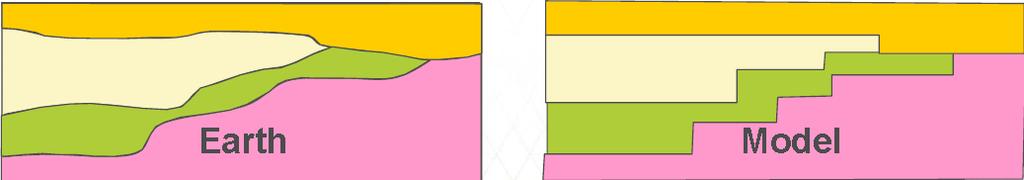
9 Models Model Types 2D models Model is unchanging perpendicular to profile section Physical properties change in all 3 directions. Generalized structure 2.5D models Model objects have limited strike length Concatenated 1D models Geometry Model Geologic unit boundaries adjust location to create 3D shapes and bodies. (after: Inversion for Applied Geophysics)
10 Why invert data? Helps explain complex data sets e.g. DCIP, Gravity Gradiometry, AEM, ZTEM, DHEM Removes topography effects Explains the data with a model(s) of the earth: Provides a quantitative model that can be analysed What is the depth, geometry, volume, physical property of the model features? More easily relates to geology - easier for interpretation What geologic features can be determined in the model? Can QC the data, identify problematic data acquisition problems Helps separate the noise from the signal in the data estimates the noise levels estimates depth of penetration


11 Example: Target in presence of geological noise Data are sometimes difficult to interpret IP data Shallow anomalies represent chargeable boulders in till Subtle responses are important Inversion result is more easily interpretable in terms of geology Recovered chargeability
12 Know The Data In order for modelling to occur, all instrument system and survey acquisition parameters have to be known. In general, try to do as little as possible to the data to preserve the information Obviously erroneous data should be removed prior to inversion. This includes features/anomalies in the data which are not modelled by the forward modelling algorithm e.g., IP or SPM effects in EM data etc RUBBISH IN = RUBBISH OUT
13 Inverse Modelling Modelling Styles Parametric few unknowns e.g. TEM decay 15 Data db/dt t 1 t 2 s 1 s 2 1D Conductivity model 7 unknown model parameters t 3 s 3 (conductivity of each layer; thickness of upper three layers) time s 4
14 Inverse Modelling Modelling Styles Parametric few unknowns Generalized many unknowns e.g. TEM decay db/dt 15 Data time 1D Conductivity model 40 unknown model parameters 1D Mesh structure predefined but smaller than expected structure of geology. structure inferred from the resulting model
15 Inverse Modelling Modelling Styles Lithology based VP suite (Fullagar Geophysics) Geomodeller (Intrepid) Physical Property based UBC-GIF codes Geosoft Voxi VP suite
16 Inverse Modelling Physical Property Based Modelling Physical property values of many individual cells are adjusted. General structure is recovered e.g. Magnetic Data 3D susceptibility model (low value cells removed)


17 Inverse Modelling Physical Property Based Modelling Physical property values of many individual cells are adjusted. General structure is recovered. e.g. Magnetic Data 3D susceptibility model (low value cells removed) 10,000+ unknown model parameters 3D Mesh structure predefined but smaller than expected structure of geology. structure inferred from the resulting model RESULT IS A PHYSICAL PROPERTY MODEL CONTAINING STRUCTURE
 10^6 10^5 10^4 10^6 10^5 10^4 1000 1000 100 100 Starting Model (courtesy Anglo American) 600 600 550 550 500 500")
18 Inverse Modelling Lithology Based Modelling Provide physical properties (single value or distribution) for each lithology and adjust the geometry to fit the data. RESULT IS A GEOLOGICAL MODEL Selected Spectrem EM Channels (Obs - blue, Calc - red) 10^6 10^5 10^4 10^6 10^5 10^ Starting Model (courtesy Anglo American) Inverted Model
19 Inverse Modelling Which Modelling Style to choose? Depends on the geophysical method, the survey design, and the exploration goal. Some examples might be: Is the goal to define the geometry/volume? Measure the physical properties well and choose a lithologic based inversion (e.g. VPmg) Is the goal to define a thickness of cover from a few TEM soundings? Use a parametric inversion Is the goal to define both physical properties and geometry? Use a generalized inversion (e.g. UBC) What geologic information is available that can be integrated into the modelling?
 than observed data points (underdetermined problem) Some physically-based")
20 Acceptable models and non-uniqueness There are infinitely many models that can explain the observed data Why is this so? Because there are usually more unknowns (model parameters) than observed data points (underdetermined problem) Some physically-based nonuniqueness Real data contain noise

21 Acceptable models and non-uniqueness There are infinitely many models that can explain the observed data
22 How to chose one of infinitely many solutions? Narrow down the range of options using prior knowledge Geophysical prior knowledge: Values are positive, and/or within bounds Physical Properties: Estimates for host rock properties Point-location values from drill hole information Logical prior knowledge: Find a simple result - as featureless as possible. This sacrifices resolution but prevents over-interpreting the data. Geological prior knowledge: Character of the model (smooth, discontinuous) Some idea of scale length (or size) of the bodies Structural Constraints
23 Model norm The model norm is a measure of the (mathematical) size of a model The inversion process is an automated decision making scheme The model norm is a way of encoding prior information in a form suitable for mathematical optimisation we seek the smallest model The model norm is part of the solution to nonuniqueness Nonuniqueness is addressed by choosing the one model (from infinitely many) that minimizes the defined model norm

24 Model norms Smooth Minimum horizontal structure Minimum vertical structure Minimise difference between the model and some reference model


25 Data misfit Measure of DIFFERENCE
: Predictions can be")
26 What is a good measure of misfit? If we assume errors follow a particular distribution then a measure of total misfit between predictions and field data can be defined d (m): Predictions can be considered OK when d (m) < tolerance We don t want to fit the data too closely or we are fitting noise Not all measures of Data Misfit are equal
27 What contributes to data noise? Natural and cultural noise sources Accuracy and precision in data measurements Data positioning errors Approximations made in forward modelling 1D 2D 3D Plates Anisotropy Discretization of topography
28 % Cu % Copper Measures of misfit Consider the problem of fitting a straight line to the data shown below: Depth in drillhole (m) The residuals are the differences between the data points and the best-fit line at each depth They may be positive or negative e 11 e 28 y = x Depth in drillhole (m)
29 Measures of misfit L1 and L2 norms
30 Measures of misfit L1 and L2 norms y = x Original data Misfit = sum of squares of residuals (L2 norm = least-squares)
31 Measures of misfit L1 and L2 norms Original data Misfit = sum of absolute values of residuals (L1 norm)
32 Measures of misfit L1 and L2 norms y = x Add an outlying data point
33 Measures of misfit L1 and L2 norms y = x One outlying data point Misfit = sum of squares of residuals (L2 norm = least-squares)
34 Measures of misfit L1 and L2 norms L1 Less affected by outliers (noise) One outlying data point Misfit = sum of absolute values of residuals (L1 norm)
 is the combined objective function b is the trade off parameter (regularisation")
35 Combining model norms and misfit A statement of the inverse problem is: Find the model which Minimises the model norm ( M ), and Produces an acceptably small data misfit ( D ) Mathematically, this becomes a single optimisation Minimise = D + b M (subject to d < tolerance) is the combined objective function b is the trade off parameter (regularisation parameter)
 optimal fit. Best estimate of a model which adequately re-creates the observations. * d b 0 m Tikhonov curve")
36 b is the regularization parameter d b Solve: (m) = d (m) + b m (m) b too large underfitting the data. Structural information lost. b too small overfitting the data. Noise becomes imaged as structure. b just right ( d N ) optimal fit. Best estimate of a model which adequately re-creates the observations. * d b 0 m Tikhonov curve
37 Inverse Modelling Non-Uniqueness: Solution (partial ) Provide explicit geological information Constraints Combine information from independent geophysical methods Joint or Cooperative Inversions e.g. Gravity with Magnetics, Airborne EM with CSAMT, etc.
38 Integrated Modelling: Constraints Sources of Data Geologic Mapping DH geological logs Interpreted cross-sections 3D geological models Physical property data per lithology Located physical property data measurements Some information is subjective and some information is objective. As with the geophysical data we would desire to quantify the uncertainty associated with this data as an input to the inversion.

39 Rock properties are the link between geology and geophysics


40 Shameless plug Mira Geoscience Rock Property Database System Free! 6 million measurements, including GSC database and published data

41 Rock Property Database System Organise, understand, preserve and provide access to physical property data
42 Common Earth Modelling Extending the model to include multiple properties, that honour multiple data sets, on a single model object. Goal: Obtain the most complete representation of the earth. Benefits: Improved resolution away from constraints Allows more precise exploration using quantitative 3D GIS analysis.
43 Common Earth Modelling: Constrained Inversion Modelling 2D Gravity Synthetic (Nick Williams)
44 Common Earth Modelling: Constrained Inversion Modelling 2D Gravity Synthetic + (Nick Williams)
45 Common Earth Modelling: Constrained Inversion Modelling 2D Gravity Synthetic + (Nick Williams)


46 Common Earth Modelling: Constrained Inversion Modelling 2D Gravity Synthetic + Surface constraints can result in dramatic improvements (Nick Williams)
47 Joint and cooperative inversion Inversion using more than one geophysical method Methods sensitive to same physical property (e.g., TEM and CSAMT) Methods sensitive to related properties (e.g., seismic and gravity) Joint inversion single objective function Cooperative inversion iterative/sequential approach These approaches require that we establish relationships between the physical properties each method is sensitive to


48 Appraisal How good is our model? Over-fitting vs under-fitting data Limits to the data Limits to the physics Depth of investigation Suite of models Point-spread functions Model resolution analysis Sensitivity analysis Extremal models Model Covariance Matrix Co-Kriging error
49 Summary and conclusion Inversion has the potential to greatly improve the geological interpretation of geophysical data High quality data is essential for the success of geophysical modelling More appropriate/efficient surveys can be designed Complex data sets can be understood (DH IP, 3D EM) Understanding physical property data is the key to successful inversion interpretation. Rock type Alteration Mineralization
50 Summary and conclusion Non uniqueness in inversion is dealt with by imposing constraints Provide the constraints or they will be provided for you Minimum structure or geological Interpretation of inversion requires understanding of which parts of the model are driven by constraints and which parts are driven by data. Requires inspection of multiple models Inspect observed and predicted data before accepting a model. Did the inversion fit the data anomalies you are interested in? Beware of over-fitting and under-fitting your data
51 Summary and conclusion Geologically constrained inversion will greatly improve your results Constraints can be factual or conceptual (hypothesis testing) Sparse or detailed From different sources Geological maps Outcrop samples Estimates of overburden depth Detailed drill data
52 Acknowledgements Nigel Phillips Dianne Mitchinson Scott Napier Shannon Frey Thomas Campagne - Mira Geoscience, Vancouver Ross Brodie - Geoscience Australia Ken Witherly - Condor Consulting Regis Neroni - FMGL Doug Oldenburg - UBC-GIF
53 Reference Inversion for Applied Geophysics
3D modeling of the Quest Projects Geophysical Datasets. Nigel Phillips
 3D modeling of the Quest Projects Geophysical Datasets Nigel Phillips Advanced Geophysical Interpretation Centre Undercover Exploration workshop KEG-25 April 2012 Mineral Physical Properties: density sus.
Introduction to Geophysical Inversion
 Introduction to Geophysical Inversion Goals Understand the non-uniqueness in geophysical interpretations Understand the concepts of inversion. Basic workflow for solving inversion problems. Some important
QUEST Project: 3D inversion modelling, integration, and visualization of airborne gravity, magnetic, and electromagnetic data, BC, Canada.
 Mira Geoscience Limited 409 Granville Street, Suite 512 B Vancouver, BC Canada V6C 1T2 Tel: (778) 329-0430 Fax: (778) 329-0668 info@mirageoscience.com www.mirageoscience.com QUEST Project: 3D inversion
Inversion concepts: Introducing geophysical inversion
 Inversion concepts: Introducing geophysical inversion This chapter deals with basic concepts underlying geophysical inversion. Four sections provide an overview of essential ideas without mentioning mathematical
Regional 3D inversion modelling of airborne gravity, magnetic, and electromagnetic data, Central BC, Canada.
 Mira Geoscience Limited 409 Granville Street, Suite 512 B Vancouver, BC Canada V6C 1T2 Tel: (778) 329-0430 Fax: (778) 329-0668 info@mirageoscience.com www.mirageoscience.com Regional 3D inversion modelling
Three-dimensional inversion of borehole, time-domain, electromagnetic data for highly conductive ore-bodies.
 Three-dimensional inversion of borehole, time-domain, electromagnetic data for highly conductive ore-bodies. Nigel Phillips, Doug Oldenburg, Eldad Haber, Roman Shekhtman. UBC-Geophysical Inversion Facility
3D Inversion of Time-Domain Electromagnetic Data for Ground Water Aquifers
 3D Inversion of Time-Domain Electromagnetic Data for Ground Water Aquifers Elliot M. Holtham 1, Mike McMillan 1 and Eldad Haber 2 (1) Computational Geosciences Inc. (2) University of British Columbia Summary
Electromagnetic migration of marine CSEM data in areas with rough bathymetry Michael S. Zhdanov and Martin Čuma*, University of Utah
 Electromagnetic migration of marine CSEM data in areas with rough bathymetry Michael S. Zhdanov and Martin Čuma*, University of Utah Summary In this paper we present a new approach to the interpretation
Airborne IP for Kimberlite
 The University of British Columbia Geophysical Inversion Facility Airborne IP for Kimberlite Douglas W. Oldenburg and Seogi Kang IP workshop 2016 June 7 th 2016 gif.eos.ubc.ca slide 1 Acknowledgements
26257 Nonlinear Inverse Modeling of Magnetic Anomalies due to Thin Sheets and Cylinders Using Occam s Method
 26257 Nonlinear Inverse Modeling of Anomalies due to Thin Sheets and Cylinders Using Occam s Method R. Ghanati* (University of Tehran, Insitute of Geophysics), H.A. Ghari (University of Tehran, Insitute
Data Acquisition. Chapter 2
 Data Acquisition Chapter 2 1 st step: get data Data Acquisition Usually data gathered by some geophysical device Most surveys are comprised of linear traverses or transects Typically constant data spacing
Oasis montaj How-To Guide. VOXI Earth Modelling - Running an Inversion Using Gradient Weighting
 Oasis montaj How-To Guide VOXI Earth Modelling - Running an Inversion Using Gradient Weighting The software described in this manual is furnished under license and may only be used or copied in accordance
GEOPHYS 242: Near Surface Geophysical Imaging. Class 8: Joint Geophysical Inversions Wed, April 20, 2011
 GEOPHYS 4: Near Surface Geophysical Imaging Class 8: Joint Geophysical Inversions Wed, April, 11 Invert multiple types of data residuals simultaneously Apply soft mutual constraints: empirical, physical,
Oasis montaj How-To Guide. VOXI Earth Modelling - Running an Inversion
 Oasis montaj How-To Guide VOXI Earth Modelling - Running an Inversion The software described in this manual is furnished under license and may only be used or copied in accordance with the terms of the
2D Inversions of 3D Marine CSEM Data Hung-Wen Tseng*, Lucy MacGregor, and Rolf V. Ackermann, Rock Solid Images, Inc.
 2D Inversions of 3D Marine CSEM Data Hung-Wen Tseng*, Lucy MacGregor, and Rolf V. Ackermann, Rock Solid Images, Inc. Summary A combination of 3D forward simulations and 2D and 3D inversions have been used
(x, y, z) m 2. (x, y, z) ...] T. m 2. m = [m 1. m 3. Φ = r T V 1 r + λ 1. m T Wm. m T L T Lm + λ 2. m T Hm + λ 3. t(x, y, z) = m 1
![(x, y, z) m 2. (x, y, z) ...] T. m 2. m = [m 1. m 3. Φ = r T V 1 r + λ 1. m T Wm. m T L T Lm + λ 2. m T Hm + λ 3. t(x, y, z) = m 1](/thumbs/73/69256451.jpg "(x, y, z) m 2. (x, y, z) ...] T. m 2. m = [m 1. m 3. Φ = r T V 1 r + λ 1. m T Wm. m T L T Lm + λ 2. m T Hm + λ 3. t(x, y, z) = m 1") Class 1: Joint Geophysical Inversions Wed, December 1, 29 Invert multiple types of data residuals simultaneously Apply soft mutual constraints: empirical, physical, statistical Deal with data in the same
Class 1: Joint Geophysical Inversions Wed, December 1, 29 Invert multiple types of data residuals simultaneously Apply soft mutual constraints: empirical, physical, statistical Deal with data in the same
Unstructured grid modelling to create 3-D Earth models that unify geological and geophysical information
 Unstructured grid modelling to create 3-D Earth models that unify geological and geophysical information Peter Lelièvre, Angela Carter-McAuslan, Cassandra Tycholiz, Colin Farquharson and Charles Hurich
Stage terrain 3A Heissenstein. Electrical surveying
 Stage terrain 3A Heissenstein Electrical surveying Introduction The principle method for measuring the surface resistivity is always the same. An electric current is sent into the subsurface through two
Incorporating FWI velocities in Simulated Annealing based acoustic impedance inversion
 Incorporating FWI velocities in Simulated Annealing based acoustic impedance inversion Date: 27 September 2018 Authors: Nasser Bani Hassan, Sean McQuaid Deterministic vs Stochastic Inversion Deterministic
Robust 3D gravity gradient inversion by planting anomalous densities
 Robust 3D gravity gradient inversion by planting anomalous densities Leonardo Uieda Valéria C. F. Barbosa Observatório Nacional September, 2011 Outline Outline Forward Problem Outline Forward Problem Inverse
EOSC 454 Lab #3. 3D Magnetics. Date: Feb 3, Due: Feb 10, 2009.
 EOSC 454 Lab #3 3D Magnetics Date: Feb 3, 2009. Due: Feb 10, 2009. 1 Introduction In this exercise you will perform both forward models and inversions of magnetic data. You will compare the response of
Dealing with uncertainty in AEM models (and learning to live with it)
") Dealing with uncertainty in AEM models (and learning to live with it) A. Yusen * Mineral Resources, CSIRO Kensington, WA, 6151, Australia yusen.ley@csiro.au SUMMARY Interpreting inversions and modelling
Dealing with uncertainty in AEM models (and learning to live with it) A. Yusen * Mineral Resources, CSIRO Kensington, WA, 6151, Australia yusen.ley@csiro.au SUMMARY Interpreting inversions and modelling
Target 3D Geology Surfaces
 Target 3D Geology Surfaces The Target 3D Geology Surfaces (Contact Surface from Geology Grids) tool enables you to create subsurface topography grids, where the "Z" values correspond to the elevation of
3D inversion of marine CSEM data: A feasibility study from the Shtokman gas field in the Barents Sea
 3D inversion of marine CSEM data: A feasibility study from the Shtokman gas field in the Barents Sea M. S. Zhdanov 1,2, M. Čuma 1,2, A. Gribenko 1,2, G. Wilson 2 and N. Black 2 1 The University of Utah,
Stage terrain 3A Heissenstein. Electrical surveying
 Stage terrain 3A Heissenstein Electrical surveying Introduction The principle method for measuring the surface resistivity is always the same. An electric current is sent into the subsurface through two
Efficient 3D Gravity and Magnetic Modeling
 Efficient 3D Gravity and Magnetic Modeling X. Li Fugro Gravity & Magnetic Services Inc., Houston, Texas, USA Summary There are many different spatial-domain algorithms for 3D gravity and magnetic forward
EMIGMA V9.x Premium Series April 8, 2015
 EMIGMA V9.x Premium Series April 8, 2015 EMIGMA for Gravity EMIGMA for Gravity license is a comprehensive package that offers a wide array of processing, visualization and interpretation tools. The package
Engineering and Environmental Geophysics with terratem
 Engineering and Environmental Geophysics with terratem (1) Geophysical Consultant Alpha Geosciences Pty. Ltd. Sydney NSW 2210 Australia Email: rhenderson@terratem.com Roger Henderson (1) ABSTRACT terratem
SUMMARY. method to synthetic datasets is discussed in the present paper.
 Geophysical modeling through simultaneous Joint Inversion of Seismic, Gravity and Magnetotelluric data Michele De Stefano (1), Daniele Colombo (1) WesternGeco EM - Geosystem, via Clericetti 42/A, 20133
Lithological and surface geometry joint inversions using multi-objective global optimization methods
 Lithological and surface geometry joint inversions using multi-objective global optimization methods Peter G. Lelièvre 1, Rodrigo Bijani and Colin G. Farquharson 1 plelievre@mun.ca http://www.esd.mun.ca/~peter/home.html
Gravity Gradients in PreStack Depth Migration
 Index Table of contents Gravity Gradients in PreStack Depth Migration Ed. K. Biegert Shell International Exploration and Production Summary Subsurface de-risking is presently almost exclusively done by
Oasis montaj How-To Guide. VOXI Earth Modelling - Running an AGG Unconstrained Inversion
 Oasis montaj How-To Guide VOXI Earth Modelling - Running an AGG Unconstrained Inversion The software described in this manual is furnished under license and may only be used or copied in accordance with
Issues During the Inversion of Crosshole Radar Data: Can We Have Confidence in the Outcome?
 Boise State University ScholarWorks Geosciences Faculty Publications and Presentations Department of Geosciences 12-1-2006 Issues During the Inversion of Crosshole Radar Data: Can We Have Confidence in
WinGLink. Geophysical interpretation software VERSION
 WinGLink Geophysical interpretation software VERSION 2.21.08 WinGLink geophysical interpretation software WinGLink Geophysical interpretation software Essential tools for data QC, processing, and modeling
Sparse wavelet expansions for seismic tomography: Methods and algorithms
 Sparse wavelet expansions for seismic tomography: Methods and algorithms Ignace Loris Université Libre de Bruxelles International symposium on geophysical imaging with localized waves 24 28 July 2011 (Joint
Joint seismic traveltime and TEM inversion for near surface imaging Jide Nosakare Ogunbo*, Jie Zhang, GeoTomo LLC
 Jide Nosaare Ogunbo*, Jie Zhang, GeoTomo LLC Summary For a reliable interpretation of the subsurface structure, the joint geophysical inversion approach is becoming a viable tool. Seismic and EM methods
We 2MIN 02 Data Density and Resolution Power in 3D DC Resistivity Surveys
 We 2MIN 02 Data Density and Resolution Power in 3D DC Resistivity Surveys M. Gharibi 1 *, R. Sharpe 1 1 Quantec Geoscience Ltd Summary Resolution power of a field 3D DC dataset is examined by gradually
M. Warner* (S-Cube), T. Nangoo (S-Cube), A. Umpleby (S-Cube), N. Shah (S-Cube), G. Yao (S-Cube)
, T. Nangoo (S-Cube), A. Umpleby (S-Cube), N. Shah (S-Cube), G. Yao (S-Cube)") Tu A12 15 High-Resolution Reflection FWI M. Warner* (S-Cube), T. Nangoo (S-Cube), A. Umpleby (S-Cube), N. Shah (S-Cube), G. Yao (S-Cube) Summary We demonstrate reflection FWI on a less-than-ideal 3D narrow-azimuth
Tu A12 15 High-Resolution Reflection FWI M. Warner* (S-Cube), T. Nangoo (S-Cube), A. Umpleby (S-Cube), N. Shah (S-Cube), G. Yao (S-Cube) Summary We demonstrate reflection FWI on a less-than-ideal 3D narrow-azimuth
Noise in FTG Data and its Comparison With Conventional Gravity Surveys
 Noise in FTG Data and its Comparison With Conventional Gravity Surveys G. Barnes, J. umley, P. Houghton, R. Gleave ARKeX td. Cambridge, U.K. Summary Employing various assumptions and approximations, we
Oasis montaj Best Practice Guide. VOXI Earth Modelling - Creating Gradient Weighting Voxels
 Oasis montaj Best Practice Guide VOXI Earth Modelling - Creating Gradient Weighting Voxels The software described in this manual is furnished under license and may only be used or copied in accordance
Tying well information and seismic data
 Stanford Exploration Project, Report 84, May 9, 2001, pages 1 319 Tying well information and seismic data Arnaud Berlioux 1 ABSTRACT Well log information and seismic data for a given horizon may not tie
Inversion after depth imaging
 Robin P. Fletcher *, Stewart Archer, Dave Nichols, and Weijian Mao, WesternGeco Summary In many areas, depth imaging of seismic data is required to construct an accurate view of the reservoir structure.
Adaptive spatial resampling as a Markov chain Monte Carlo method for uncertainty quantification in seismic reservoir characterization
 1 Adaptive spatial resampling as a Markov chain Monte Carlo method for uncertainty quantification in seismic reservoir characterization Cheolkyun Jeong, Tapan Mukerji, and Gregoire Mariethoz Department
Integral equation method for anisotropic inversion of towed streamer EM data: theory and application for the TWOP survey
 Integral equation method for anisotropic inversion of towed streamer EM data: theory and application for the TWOP survey Michael S. Zhdanov 1,2, Masashi Endo 1, Daeung Yoon 1,2, Johan Mattsson 3, and Jonathan
D020 Statics in Magnetotellurics - Shift or Model?
 D020 Statics in Magnetotellurics - Shift or Model? W. Soyer* (WesternGeco-Geosystem), S. Hallinan (WesternGeco- Geosystem), R.L. Mackie (WesternGeco-Geosystem) & W. Cumming (Cumming Geoscience) SUMMARY
Geophysics 224 B2. Gravity anomalies of some simple shapes. B2.1 Buried sphere
 Geophysics 4 B. Gravity anomalies of some simple shapes B.1 Buried sphere Gravity measurements are made on a surface profile across a buried sphere. The sphere has an excess mass M S and the centre is
Total variation tomographic inversion via the Alternating Direction Method of Multipliers
 Total variation tomographic inversion via the Alternating Direction Method of Multipliers Landon Safron and Mauricio D. Sacchi Department of Physics, University of Alberta Summary Geophysical inverse problems
Temporal Integration Of Seismic Traveltime Tomography
 Temporal Integration Of Seismic Traveltime Tomography Jonathan B Ajo-Franklin, Earth Resources Laboratory Dept of Earth, Atmospheric, and Planetary Sciences Massachusetts Institute of Technology Cambridge,
Oasis montaj Best Practice Guide. VOXI Earth Modelling - Preparing Data for Inversion
 Oasis montaj Best Practice Guide VOXI Earth Modelling - Preparing Data for Inversion The software described in this manual is furnished under license and may only be used or copied in accordance with the
Curvature. Definition of curvature in 2D and 3D
 Curvature Deformation associated with folding and faulting alters the location and shape of geological surfaces. In Move, the strain caused by deformation can be quantified using restoration algorithms
Mo 21P1 08 Comparison of Different Acquisition Patterns for 2D Tomographic Resistivity Surveys
 Mo 21P1 08 Comparison of Different Acquisition Patterns for 2D Tomographic Resistivity Surveys R. Martorana* (University of Palermo), P. Capizzi (University of Palermo), A. D'Alessandro (INGV - Roma) &
A MATLAB-Based Numerical and GUI Implementation of Cross-Gradients Joint Inversion of Gravity and Magnetic Data
 Journal of Software Engineering and Applications, 2015, 8, 93-101 Published Online February 2015 in SciRes. http://www.scirp.org/journal/jsea http://dx.doi.org/10.4236/jsea.2015.82010 A MATLAB-Based Numerical
prismatic discretization of the digital elevation model, and their associated volume integration problems. Summary
 A new method of terrain correcting airborne gravity gradiometry data using 3D Cauchy-type integrals Michael S. Zhdanov*, University of Utah and TechnoImaging, Glenn A. Wilson, TechnoImaging, and Xiaojun
SUMMARY. denoise the original data at each iteration. This can be
 A comparison of D reconstruction methods Aaron Stanton*, Nadia Kreimer, David Bonar, Mostafa Naghizadeh, and Mauricio Sacchi, Department of Physics, University of Alberta SUMMARY A comparison is made between
Improved image segmentation for tracking salt boundaries
 Stanford Exploration Project, Report 115, May 22, 2004, pages 357 366 Improved image segmentation for tracking salt boundaries Jesse Lomask, Biondo Biondi and Jeff Shragge 1 ABSTRACT Normalized cut image
Oasis montaj Best Practice Guide. VOXI Earth Modelling - Rules of Thumb for Voxel Element Sizes
 Oasis montaj Best Practice Guide VOXI Earth Modelling - Rules of Thumb for Voxel Element Sizes The software described in this manual is furnished under license and may only be used or copied in accordance
Getting Started with montaj GridKnit
 Getting Started with montaj GridKnit Today s explorers use regional and local geophysical compilations of magnetic, radiometric and apparent resistivity data to perform comprehensive geologic interpretations
Application of wavelet theory to the analysis of gravity data. P. Hornby, F. Boschetti* and F. Horowitz, Division of Exploration and Mining, CSIRO,
 Application of wavelet theory to the analysis of gravity data. P. Hornby, F. Boschetti* and F. Horowitz, Division of Exploration and Mining, CSIRO, Australia. Summary. The fundamental equations of potential
Interpreting Data in IX1D v 3 A Tutorial
 Interpreting Data in IX1D v 3 A Tutorial Version 1.0 2006 Interpex Limited All rights reserved Select a Sounding from the Map Display using the Mouse If you right-click on the sounding, there are more
REPORT ON A 3D INDUCED POLARISATION SURVEY OVER THE HOMEEP AND SHIRLEY TRENDS, CONCORDIA DISTRICT, NORTHERN CAPE
 GEOSPEC INSTRUMENTS (PTY) LTD REPORT ON A 3D INDUCED POLARISATION SURVEY OVER THE HOMEEP AND SHIRLEY TRENDS, CONCORDIA DISTRICT, NORTHERN CAPE PREPARED FOR MINXCOM (Pty) Ltd and Galileo Resources PLC BY
Question: What are the origins of the forces of magnetism (how are they produced/ generated)?
?") This is an additional material to the one in the internet and may help you to develop interest with the method. You should try to integrate some of the discussions here while you are trying to answer the
This is an additional material to the one in the internet and may help you to develop interest with the method. You should try to integrate some of the discussions here while you are trying to answer the
Closing the Loop via Scenario Modeling in a Time-Lapse Study of an EOR Target in Oman
 Closing the Loop via Scenario Modeling in a Time-Lapse Study of an EOR Target in Oman Tania Mukherjee *(University of Houston), Kurang Mehta, Jorge Lopez (Shell International Exploration and Production
Tensor Based Approaches for LVA Field Inference
 Tensor Based Approaches for LVA Field Inference Maksuda Lillah and Jeff Boisvert The importance of locally varying anisotropy (LVA) in model construction can be significant; however, it is often ignored
Model parametrization strategies for Newton-based acoustic full waveform
 Model parametrization strategies for Newton-based acoustic full waveform inversion Amsalu Y. Anagaw, University of Alberta, Edmonton, Canada, aanagaw@ualberta.ca Summary This paper studies the effects
Potent can model multi-component data, such as down-hole Fx, Fy, Fz magnetic data, or tensor gravity data.
 Getting Started What is Potent? Main concepts A simple tutorial What is Potent? Potent is a program for modelling the magnetic and gravitational effects of subsurface structures. It provides a highly interactive
GG450 4/5/2010. Today s material comes from p and in the text book. Please read and understand all of this material!
 GG450 April 6, 2010 Seismic Reflection I Today s material comes from p. 32-33 and 81-116 in the text book. Please read and understand all of this material! Back to seismic waves Last week we talked about
Gravity Methods (VII) wrap up
 wrap up") Environmental and Exploration Geophysics II Gravity Methods (VII) wrap up tom.h.wilson tom.wilson@mail.wvu.edu Department of Geology and Geography West Virginia University Morgantown, WV Items on the list
Environmental and Exploration Geophysics II Gravity Methods (VII) wrap up tom.h.wilson tom.wilson@mail.wvu.edu Department of Geology and Geography West Virginia University Morgantown, WV Items on the list
High definition tomography brings velocities to light Summary Introduction Figure 1:
 Saverio Sioni, Patrice Guillaume*, Gilles Lambaré, Anthony Prescott, Xiaoming Zhang, Gregory Culianez, and Jean- Philippe Montel (CGGVeritas) Summary Velocity model building remains a crucial step in seismic
Seismic Time Processing. The Basis for Modern Seismic Exploration
 The Future of E&P Seismic Time Processing The Basis for Modern Seismic Exploration Fusion is a leading provider of Seismic Processing for the oil and gas industry from field tapes through final migration.
Noise-thresholding sparse-spike inversion with global convergence: calibration and applications
 Noise-thresholding sparse-spike inversion with global convergence: calibration and applications Douglas S. Sassen and Michael Glinsky, Ion Geophysical 2013 SEG Douglas Sassen 9/25/13 1 Illustrative Abstract!
Target Lithology Voxels
 Target Lithology Voxels The Target Lithology Voxels tool enables you to create a 3D grid (voxel) based on data contained in a string channel within a from-to drillhole database. A lithology voxel can be
Timelapse ERT inversion approaches and their applications
 Timelapse ERT inversion approaches and their applications THOMAS GÜNTHER Leibniz-Institute for Applied Geophysics (LIAG), Hannover, Germany. thomas.guenther@liag-hannover.de Introduction Aim of timelapse
FINITE ELEMENT MODELING OF IP ANOMALOUS EFFECT FROM BODIES OF ANY GEOMETRICAL SHAPE LOCATED IN RUGED RELIEF AREA
 FINITE ELEMENT MODELING OF IP ANOMALOUS EFFECT FROM BODIES OF ANY GEOMETRICAL SHAPE LOCATED IN RUGED RELIEF AREA Alfred FRASHËRI, Neki FRASHËRI Geophysical Technologist Training Program Quantec Geophysics
Effects of multi-scale velocity heterogeneities on wave-equation migration Yong Ma and Paul Sava, Center for Wave Phenomena, Colorado School of Mines
 Effects of multi-scale velocity heterogeneities on wave-equation migration Yong Ma and Paul Sava, Center for Wave Phenomena, Colorado School of Mines SUMMARY Velocity models used for wavefield-based seismic
2010 SEG SEG Denver 2010 Annual Meeting
 Localized anisotropic tomography with checkshot : Gulf of Mexico case study Andrey Bakulin*, Yangjun (Kevin) Liu, Olga Zdraveva, WesternGeco/Schlumberger Summary Borehole information must be used to build
Geogiga Seismic Pro 8.3 Release Notes
 Geogiga Seismic Pro 8.3 Release Notes Copyright 2017, All rights reserved. Table of Contents Introduction...1 Part 1 Utility Modules...2 Part 2 Reflection Modules...4 Updates in SF Imager...5 Updates in
The determination of the correct
 SPECIAL High-performance SECTION: H i gh-performance computing computing MARK NOBLE, Mines ParisTech PHILIPPE THIERRY, Intel CEDRIC TAILLANDIER, CGGVeritas (formerly Mines ParisTech) HENRI CALANDRA, Total
Adaptive Waveform Inversion: Theory Mike Warner*, Imperial College London, and Lluís Guasch, Sub Salt Solutions Limited
 Adaptive Waveform Inversion: Theory Mike Warner*, Imperial College London, and Lluís Guasch, Sub Salt Solutions Limited Summary We present a new method for performing full-waveform inversion that appears
Elastic full waveform Inversion for land walkaway VSP data
 Elastic full waveform Inversion for land walkaway VSP data Olga Podgornova, Scott Leaney, arwan Charara, Schlumberger; Eric von Lunen, Nexen Energy ULC Summary Full waveform inversion (FWI) is capable
We Survey Design and Modeling Framework for Towed Multimeasurement Seismic Streamer Data
 We-04-12 Survey Design and Modeling Framework for Towed Multimeasurement Seismic Streamer Data K. Eggenberger* (Schlumberger), P. Christie (Schlumberger), M. Vassallo (Schlumberger) & D.J. van Manen (Schlumberger)
Stabilization of the Euler deconvolution algorithm by means of a two steps regularization approach
 Stabilization of the Euler deconvolution algorithm by means of a two steps regularization approach R. Pašteka ( 1,2 ), D. Kušnirák ( 1 ), H.-J. Götze ( 2 ) ( 1 )Department of Applied Geophysics, Comenius
Main Menu. Well. is the data misfit vector, corresponding to residual moveout, well misties, etc. The L matrix operator contains the d / α
 Application of steering filters to localized anisotropic tomography with well data Andrey Bakulin, Marta Woodward*, Yangjun (Kevin) Liu, Olga Zdraveva, Dave Nichols, Konstantin Osypov WesternGeco Summary
TRAVELTIME TOMOGRAPHY (CONT)
") 30 March 005 MODE UNIQUENESS The forward model TRAVETIME TOMOGRAPHY (CONT di = A ik m k d = Am (1 Data vecto r Sensitivit y matrix Model vector states the linearized relationship between data and model
30 March 005 MODE UNIQUENESS The forward model TRAVETIME TOMOGRAPHY (CONT di = A ik m k d = Am (1 Data vecto r Sensitivit y matrix Model vector states the linearized relationship between data and model
cv R z design. In this paper, we discuss three of these new methods developed in the last five years.
 Nick Moldoveanu, Robin Fletcher, Anthony Lichnewsky, Darrell Coles, WesternGeco Hugues Djikpesse, Schlumberger Doll Research Summary In recent years new methods and tools were developed in seismic survey
Experimental Evaluation of 3D Geoelectrical Resistivity Imaging using Orthogonal 2D Profiles
 Experimental Evaluation of 3D Geoelectrical Resistivity Imaging using Orthogonal 2D Profiles A. P. Aizebeokhai 1 *, A. I. Olayinka 2, V. S. Singh 3 and O. A. Oyebanjo 4 1 Department of Physics, Covenant
Introduction to seismic body waves Tomography
 Introduction to seismic body waves Tomography Presented by Han Zhang Prepared by group work of Justin Wilgus and Han Zhang Outlines 1. Velocity derived from wave equation 2. Two commonly used reference
Geometric theory of inversion and seismic imaging II: INVERSION + DATUMING + STATIC + ENHANCEMENT. August Lau and Chuan Yin.
 Geometric theory of inversion and seismic imaging II: INVERSION + DATUMING + STATIC + ENHANCEMENT August Lau and Chuan Yin January 6, 2017 Abstract The goal of seismic processing is to convert input data
Geostatistics 2D GMS 7.0 TUTORIALS. 1 Introduction. 1.1 Contents
 GMS 7.0 TUTORIALS 1 Introduction Two-dimensional geostatistics (interpolation) can be performed in GMS using the 2D Scatter Point module. The module is used to interpolate from sets of 2D scatter points
Improvements in time domain FWI and its applications Kwangjin Yoon*, Sang Suh, James Cai and Bin Wang, TGS
 Downloaded 0/7/13 to 05.196.179.38. Redistribution subject to SEG license or copyright; see Terms of Use at http://library.seg.org/ Improvements in time domain FWI and its applications Kwangjin Yoon*,
Application of MPS Simulation with Multiple Training Image (MultiTI-MPS) to the Red Dog Deposit
 to the Red Dog Deposit") Application of MPS Simulation with Multiple Training Image (MultiTI-MPS) to the Red Dog Deposit Daniel A. Silva and Clayton V. Deutsch A Multiple Point Statistics simulation based on the mixing of two
Application of MPS Simulation with Multiple Training Image (MultiTI-MPS) to the Red Dog Deposit Daniel A. Silva and Clayton V. Deutsch A Multiple Point Statistics simulation based on the mixing of two
GOCAD Mining Suite 17 update1 - Release notes
 GOCAD Mining Suite 17 update1 - Release notes 2018 Paradigm B. V. and Mira Geoscience Limited. All rights reserved. The information in this document is subject to change without notice and should not be
Mitigating Uncertainties in Towed Streamer Acquisition and Imaging by Survey Planning
 Mitigating Uncertainties in Towed Streamer Acquisition and Imaging by Survey Planning M.T. Widmaier* (Petroleum Geo-Services) SUMMARY Uncertainties in seismic images or reservoir characterisation can very
P257 Transform-domain Sparsity Regularization in Reconstruction of Channelized Facies
 P257 Transform-domain Sparsity Regularization in Reconstruction of Channelized Facies. azemi* (University of Alberta) & H.R. Siahkoohi (University of Tehran) SUMMARY Petrophysical reservoir properties,
Combined Electrical and Magnetic Resistivity Tomography (ERT/MMR)
") Combined Electrical and Magnetic Resistivity Tomography (ERT/MMR) Gail Heath 1, John M. Svoboda 1, Birsen Canan 2, Shannon Ansley 1, David Alumbaugh 3, Douglas LaBrecque 4, Roger Sharpe 4,Roelof Versteeg
Combined Electrical and Magnetic Resistivity Tomography (ERT/MMR) Gail Heath 1, John M. Svoboda 1, Birsen Canan 2, Shannon Ansley 1, David Alumbaugh 3, Douglas LaBrecque 4, Roger Sharpe 4,Roelof Versteeg
Tu A4 09 3D CSEM Inversion Of Data Affected by Infrastructure
 Tu A4 09 3D CSEM Inversion Of Data Affected by Infrastructure J.P. Morten (EMGS), L. Berre* (EMGS), S. de la Kethulle de Ryhove (EMGS), V. Markhus (EMGS) Summary We consider the effect of metal infrastructure
Summary. Introduction
 Chris Davison*, Andrew Ratcliffe, Sergio Grion (CGGeritas), Rodney Johnston, Carlos Duque, Jeremy Neep, Musa Maharramov (BP). Summary Azimuthal velocity models for HTI (Horizontal Transverse Isotropy)
GRAV3D Version 3.0. A Program Library for Forward Modelling and Inversion of Gravity Data over 3D Structures.
 GRAV3D Version 3.0 A Program Library for Forward Modelling and Inversion of Gravity Data over 3D Structures. UBC-Geophysical Inversion Facility Department of Earth and Ocean Sciences University of British
MAPPING POISSON S RATIO OF UNCONSOLIDATED MATERIALS FROM A JOINT ANALYSIS OF SURFACE-WAVE AND REFRACTION EVENTS INTRODUCTION
 MAPPING POISSON S RATIO OF UNCONSOLIDATED MATERIALS FROM A JOINT ANALYSIS OF SURFACE-WAVE AND REFRACTION EVENTS Julian Ivanov, Choon B. Park, Richard D. Miller, and Jianghai Xia Kansas Geological Survey
Deconvolution with curvelet-domain sparsity Vishal Kumar, EOS-UBC and Felix J. Herrmann, EOS-UBC
 Deconvolution with curvelet-domain sparsity Vishal Kumar, EOS-UBC and Felix J. Herrmann, EOS-UBC SUMMARY We use the recently introduced multiscale and multidirectional curvelet transform to exploit the
Benefits of Integrating Rock Physics with Petrophysics
 Benefits of Integrating Rock Physics with Petrophysics Five key reasons to employ an integrated, iterative workflow The decision to take a spudded well to completion depends on the likely economic payout.