Working with M 3 Data. Jeff Nettles M 3 Data Tutorial at AGU December 13, 2010
|
|
|
- Rosalind Harrington
- 6 years ago
- Views:
Transcription
1 Working with M 3 Data Jeff Nettles M 3 Data Tutorial at AGU December 13, 2010
2 For Reference Slides and example data from today s workshop available at See Green et al. (2010) and Boardman et al. (2010) for complete descriptions of topics discussed here
3 Topics to be discussed M3 observation history Instrument design Data set description Calibration pipeline Walkthrough of calculating I/F with M3 L1B data in ENVI slides online at
4 M3 Mission History
5 Planned vs. Actual Flight Planned observation time was 4 two-month optical periods defined by equatorial solar zenith of 0-30 One month was to be contiguous low-resolution (Global Mode) overview; the remainder was to be used for the optimal high-resolution resolution data (Target Mode).
6 Planned vs. Actual Flight Thermal issues plagued the spacecraft as soon as it arrived at the Moon on November 8, 2008 Lost the 1 st of 2 star trackers before a single image was taken Extended commissioning phase was required, lasting into Jan 2009
7 Planned Vs. Actual Flight The ISRO Chandrayaan-1 Mission Operations team did a fantastic job redesigning the mission in real time throughout the mission lifetime Despite all the challenges, M3 was able to meet minimum mission requirements thanks to heroic efforts on the part of Ch-1 and M3 team members LOLA topography data was essential for orthorectification
8 Impact on data: Planned vs. Actual Flight Instrument was operated at less favorable viewing conditions, resulting in lower reflected surface signal, increased effects of shadows and highly variable thermal environment The spacecraft acquired data intermittently during two optical periods Almost all M3 data were acquired in reduced resolution (Global) mode; very few optimal resolution (Target) mode data acquired Most of 2 nd optical period taken at higher orbit (200km vs 100km) and with no star tracker
9 M3 Optical Periods M3 observed data during two optical periods The team subdivided the optical periods based on data characteristics: Period Dates Image Strips Orbit Star Sensors Status OP1A Nov 18 Jan km 1 of 2 OP1B Jan 25 Feb km 1 of 2 OP2A Apr 15 Apr km 1 of 2 OP2B May 13 May km 0 of 2 OP2C May 20 Aug km 0 of 2 extended commissioning operational, high solar zenith angles operational, high solar zenith angles S/C emergency, orbit raised operational, variable conditions
 and")
10 M3 Environment During Data Acquisition Optimal low detector temperature acquistions occurred during highest beta angles (angle between orbit plane and sun direction) and lowest signal

11 M3 Coverage per OP + Targets
12 PDS Delivery Schedule Level 0 and Level 1B: OP1: June 2010 OP2: December 31, 2010 Level 2: OP1 and OP2: June 2011 still in progress L0 = raw spacecraft data, L1B=radiance + backplanes, L2 = reflectance
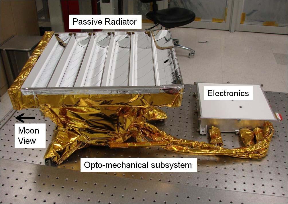
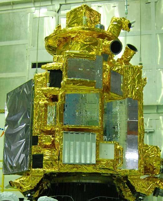
13 M3 Instrument


14 Target (Optimal Resolution) High spatial/spectral resolution mode Only a few target observations were actually acquired Global M3 Instrument acquires full resolution data then onboard software averages data to produce reduced resolution data Lower resolution mode for mapping the entire Moon Almost all M3 data were acquired in Global mode Operational Modes
15 Spatial and Spectral Resolution Spectral Coverage: Target: nm Spectral Resolution: Target: 10nm Global: 20 or 40 nm Spatial Resolution: Target: 70 m/pixel Global: 140 m/pixel from 200 km orbit spatial sampling remains 140 m/pixel, but cross-track is ~280m/pixel
16 Instrument Design Pushbroom spectrometer Each detector readout is 1 line of an image cube. The entire image is built as M3 moves along the ground track. High Spectral/Spatial Uniformity Greater than 90% spectral crosstrack and spectral IFOV uniformity
17 M3 File Formats/PDS Structure


18 PDS Directory Structure Standard PDS structure
19 M3 File Naming Convention M3G T113444_V01_RDN.IMG Basename Version Data Type Basename covered next slide Version always V01 in June 2010 L1B PDS delivery Data type tells you the type of information stored in the file Possible values in L1B delivery: L0 raw spacecraft data RDN radiance File Type OBS observational data (incidence, emission, phase angles, etc.) LOC location data (latitude, longitude, radius) TIM time of observation File Type tells you the file format Possible Values in L1B delivery: IMG raw binary image data HDR ENVI header L0, L1B PDS label type LBL PDS label TAB tabular data stored in ASCII format
20 M3 File Naming Convention (cont d) Example Basename: M3G T M3 G T Always M3 Year Month Day Hour Observation mode: G=Global, T=Target Always T Minutes Seconds Note: Sorting by filename is only equivalent to sorting by observation time if you do not have global and target data mixed together. If you do have a mix of the two, remove the first three characters then sort by filename to also sort by observation time.
21 M3 image data format The following applies to all M3 image data: Files are raw binary data (no offset) Interleave is BIL (line-interleaved) Global data have 304 samples (columns) for all image types (except L0, which has 320) Target data have 608 samples (L0 has 640) Number of lines (rows) is variable (determined by length of observation) Data type is 32-bit floating point (LOC files are 64- bit double precision floating point) Backplanes = OBS, LOC, and TIM files
 The 16 columns that are removed are for monitoring")
22 M3 Data types: L0 M3G T033545_V01_L0.IMG L0 is raw spacecraft data, units are DN 320 samples which are reduced to 304 when converted to radiance (in Global mode, Target mode is 640/608) The 16 columns that are removed are for monitoring dark signal level and scattered light Each frame has a 1280-byte header To directly compare L0 to radiance: No sample or line flip starting Nov Sample only flip starting Dec Line only flip starting Mar Sample and line flip starting Jun
 Steps used to create radiance described in calibration slides PDS label or ENVI header can be used to open ENVI header contains: Calibration steps")
23 M3 Data Types: L1B RDN M3G T033545_V01_RDN.IMG Radiance data, units W/(m 2 Sr µm) Steps used to create radiance described in calibration slides PDS label or ENVI header can be used to open ENVI header contains: Calibration steps Target wavelengths Target FWHM Dark Signal Image Anomalous Detector Map Flat Field Image Detector Temperature Beta Angle Sample/Line flip code
24 M3 Data Types: OBS List of bands in OBS file: To-Sun Azimuth (deg) To-Sun Zenith (deg) To-M3 Azimuth (deg) To-M3 Zenith (deg) Phase (deg) To-Sun Path Length (au ) To-M3 Path Length (m) Facet Slope (deg) Facet Aspect (deg) Facet Cos(i) (unitless) Scene-mean to-sun path length (Different for each scene) Values in the To-Sun Path Length band are the difference from the scene mean path length.


25 M3 Data Types: OBS Phase band Facet cos(i) band
26 M3 Data Types: LOC List of channels in LOC file: Longitude (Degrees East 0-360) Latitude Radius Subtract lunar radius of km to get difference in elevation from reference sphere Based on LOLA topography (Boardman, 2010) Reference frame is Moon Mean Earth Polar Axes (MOON_ME) frame


27 M3 Data Types: LOC Band 3 Radius 750nm albedo draped over Radius band

28 M3 Data Types: TIM One ASCII text record per frame: Column 2: UTC Time Column 1: Frame Number Column 3: Year In OP2 the S/C is ascending and the time listing is reversed Column 4: Decimal Day of Year
29 Good Stuff in the PDS Directories CALIB Record of detector temperatures, band pass functions, spectral calib. file (wavelength center positions), radiometric calibration coefficients DOCUMENT Data Product SIS document that describes all files released to PDS down to the byte level, Archive Volume SIS describes PDS directory structure EXTRAS Flat fields, anomalous detector element maps, quicklooks
30 Calibration
31 Current steps in radiance calibration (Version R) Raw image; Dark signal subtraction; Anomalous detector element interpolation; Interpolate filter edges c13, c50; Interpolate detector panel edges s81, s161, s241; Electronic panel ghost correction; Dark pedestal shift correction; Scattered light correction; Laboratory flat field; Image based flat field w/ photometry preserved; Apply radiometric calibration coefficients; Units (W/m^2/um/sr) See Green et al (2010) for detailed description
32 Basic calibration equation L = RCC ( C, (,, λ λ s λ DNl, s, λ DS l s s, λ L = calibrated radiance RCC = Radiometric calibration coefficients C = term encompassing all correction factors (flat fields,etc.) DN = raw digital number DS = dark signal )
33 Initial Steps of (ongoing) Level 2 Preparation
34 Converting Radiance to Reflectance Official M3 L2 Product is still under development Until that is available, team use an intermediate product called I/F I F = L π F d 2 Where: L = measured radiance in W/m 2 /Sr/µm F = solar flux (solar spectrum) in W/m 2 /µm d = Moon-Sun distance in AU
35 Download M3 Solar Spectrum MODTRAN-based (See Green et al, 2010) Global resolution version can be downloaded in ASCII format from the above link
36 Download M3 Solar Spectrum File is tabdelimited ASCII text 3 lines of header information to be skipped when importing
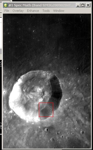
37 Example conversion of radiance to I/F in ENVI


38 Step 1: Import M3 Spectral Library Step 1: Step 2: (Can also choose ASCII File. here but that has more steps)


39 Step 1: Import M3 Spectral Library Step 3: Step 4:


40 Step 1: Import M3 Spectral Library Step 3: Done! Click Plot (Can save file as spectral library from File menu)
41 Step 2: Open Files Open radiance (RDN) file in ENVI: File > Open Image File Open observations (OBS) file also This step can be skipped if you want to use 1.0 AU for the Moon-Sun distance (~2% error) Open and plot the M3 solar spectrum if you have not already

42 Step 3: Get the Moon-Sun Distance Get mean distance from list of band names of the OBS file Could use perpixel values in the To-Sun Path Length Band (band math)

43 Step 4: Call Spectral Math Select Spectral Math under Basic Tools menu (also under Spectral menu)
/s2 I F = Lπd F 2 Radiance Double precision π Moon-Sun distance")
44 Step 5: Enter the expression Expression is: (s1*!dpi* ^2)/s2 I F = Lπd F 2 Radiance Double precision π Moon-Sun distance squared Solar Spectrum


45 Step 6: Define s1 Click Map Variable to Input File and select your radiance (RDN) file Should end up with this:
46 Step 7: Define s2 First Click Second Click


47 Step 8: Choose Output File Then click OK and ENVI goes to work

48 Last Step: Enjoy!
49 Check your work! Example radiance, observations, and I/F file posted to M3 website so that you can make sure you get the same answer we do: Presentation slides available there also
CRISM (Compact Reconnaissance Imaging Spectrometer for Mars) on MRO. Calibration Upgrade, version 2 to 3
 on MRO. Calibration Upgrade, version 2 to 3") CRISM (Compact Reconnaissance Imaging Spectrometer for Mars) on MRO Calibration Upgrade, version 2 to 3 Dave Humm Applied Physics Laboratory, Laurel, MD 20723 18 March 2012 1 Calibration Overview 2 Simplified
CRISM (Compact Reconnaissance Imaging Spectrometer for Mars) on MRO Calibration Upgrade, version 2 to 3 Dave Humm Applied Physics Laboratory, Laurel, MD 20723 18 March 2012 1 Calibration Overview 2 Simplified
CRISM Instrument, Mission, and Data Set Description
 CRISM Instrument, Mission, and Data Set Description 22 March 2009 Scott L. Murchie and the CRISM team 1 Topics to be Discussed Instrument characteristics Hardware overview Data configuration and characteristics
Kaguya s HDTV and Its Imaging
 Kaguya s HDTV and Its Imaging C h a p t e r 2 Overview of the HDTV System In addition to Kaguya s 13 science instruments, the HDTV was unique in being specifically included to engage the public in the
GOCI Post-launch calibration and GOCI-II Pre-launch calibration plan
 Breakout Session: Satellite Calibration, IOCS Meeting 2015, 18 June 2015. GOCI Post-launch calibration and GOCI-II Pre-launch calibration plan Seongick CHO Korea Ocean Satellite Center, Korea Institute
GEOG 4110/5100 Advanced Remote Sensing Lecture 2
 GEOG 4110/5100 Advanced Remote Sensing Lecture 2 Data Quality Radiometric Distortion Radiometric Error Correction Relevant reading: Richards, sections 2.1 2.8; 2.10.1 2.10.3 Data Quality/Resolution Spatial
SPICAM Archive Tutorial. Principal Investigator : J.L. Bertaux Archive Manager : A. Reberac
 SPICAM Archive Tutorial Principal Investigator : J.L. Bertaux Archive Manager : A. Reberac 1 SPICAM Archive Tutorial SPICAM Instrument SPICAM data levels/products SPICAM Archive volume set organization
Introduction to Remote Sensing Wednesday, September 27, 2017
 Lab 3 (200 points) Due October 11, 2017 Multispectral Analysis of MASTER HDF Data (ENVI Classic)* Classification Methods (ENVI Classic)* SAM and SID Classification (ENVI Classic) Decision Tree Classification
Improvements to Ozone Mapping Profiler Suite (OMPS) Sensor Data Record (SDR)
 Sensor Data Record (SDR)") Improvements to Ozone Mapping Profiler Suite (OMPS) Sensor Data Record (SDR) *C. Pan 1, F. Weng 2, T. Beck 2 and S. Ding 3 * 1 ESSIC, University of Maryland, College Park, MD 20740; 2 NOAA NESDIS/STAR,
Improvements to Ozone Mapping Profiler Suite (OMPS) Sensor Data Record (SDR) *C. Pan 1, F. Weng 2, T. Beck 2 and S. Ding 3 * 1 ESSIC, University of Maryland, College Park, MD 20740; 2 NOAA NESDIS/STAR,
Revision History. Applicable Documents
 Revision History Version Date Revision History Remarks 1.0 2011.11-1.1 2013.1 Update of the processing algorithm of CAI Level 3 NDVI, which yields the NDVI product Ver. 01.00. The major updates of this
MRO CRISM TRR3 Hyperspectral Data Filtering
 MRO CRISM TRR3 Hyperspectral Data Filtering CRISM Data User's Workshop 03/18/12 F. Seelos, CRISM SOC CRISM PDS-Delivered VNIR TRR3 I/F 3-Panel Plot False Color RGB Composite Composite band distribution
Data Processing Status
 Data Processing Status William Vacca Assoc. Director, Science Data Systems USRA-SOFIA SOFIA Users Group Meeting #10 November 2016 SOFIA Pipeline Products Defined in the Data Processing Plan for SOFIA SIs
Multi-sensors vicarious calibration activities at CNES
 Multi-sensors vicarious calibration activities at CNES Patrice Henry, Bertrand Fougnie June 11, 2013 CNES background in image quality monitoring of operational Earth observation systems Since the launch
TOPOGRAPHIC NORMALIZATION INTRODUCTION
 TOPOGRAPHIC NORMALIZATION INTRODUCTION Use of remotely sensed data from mountainous regions generally requires additional preprocessing, including corrections for relief displacement and solar illumination
The Gain setting for Landsat 7 (High or Low Gain) depends on: Sensor Calibration - Application. the surface cover types of the earth and the sun angle
 depends on: Sensor Calibration - Application. the surface cover types of the earth and the sun angle") Sensor Calibration - Application Station Identifier ASN Scene Center atitude 34.840 (34 3'0.64"N) Day Night DAY Scene Center ongitude 33.03270 (33 0'7.72"E) WRS Path WRS Row 76 036 Corner Upper eft atitude
Sensor Calibration - Application Station Identifier ASN Scene Center atitude 34.840 (34 3'0.64"N) Day Night DAY Scene Center ongitude 33.03270 (33 0'7.72"E) WRS Path WRS Row 76 036 Corner Upper eft atitude
Laser Beacon Tracking for High-Accuracy Attitude Determination
 Laser Beacon Tracking for High-Accuracy Attitude Determination Tam Nguyen Massachusetts Institute of Technology 29 th AIAA/USU Conference on Small Satellites SSC15-VIII-2 08/12/2015 Outline Motivation
IMAGING SPECTROMETER DATA CORRECTION
 S E S 2 0 0 5 Scientific Conference SPACE, ECOLOGY, SAFETY with International Participation 10 13 June 2005, Varna, Bulgaria IMAGING SPECTROMETER DATA CORRECTION Valentin Atanassov, Georgi Jelev, Lubomira
Airborne Hyperspectral Imaging Using the CASI1500
 Airborne Hyperspectral Imaging Using the CASI1500 AGRISAR/EAGLE 2006, ITRES Research CASI 1500 overview A class leading VNIR sensor with extremely sharp optics. 380 to 1050nm range 288 spectral bands ~1500
ASTER User s Guide. ERSDAC Earth Remote Sensing Data Analysis Center. 3D Ortho Product (L3A01) Part III. (Ver.1.1) July, 2004
 Part III. (Ver.1.1) July, 2004") ASTER User s Guide Part III 3D Ortho Product (L3A01) (Ver.1.1) July, 2004 ERSDAC Earth Remote Sensing Data Analysis Center ASTER User s Guide Part III 3D Ortho Product (L3A01) (Ver.1.1) TABLE OF CONTENTS
ASTER User s Guide Part III 3D Ortho Product (L3A01) (Ver.1.1) July, 2004 ERSDAC Earth Remote Sensing Data Analysis Center ASTER User s Guide Part III 3D Ortho Product (L3A01) (Ver.1.1) TABLE OF CONTENTS
Definition of Level 1B Radiance product for OMI
 Definition of Level 1B Radiance product for OMI document: RS-OMIE-KNMI-206 version: 1.0 date: 31 July 2000 authors: J.P. Veefkind KNMI veefkind@knmi.nl A. Mälkki FMI anssi.malkki@fmi.fi R.D. McPeters NASA
GENESIS Generator of Spectral Image Simulations
 MBT Space Division - GENESIS Generator of Spectral Image Simulations Dr. Yael Efraim, Dr. N. Cohen, Dr. G. Tidhar, Dr. T. Feingersh Dec 2017 1 Scope GENESIS: End-to-end simulation of hyper-spectral (HS)
UCD discussion from SSIG. B. Cecconi, S. Erard, P. Le Sidaner Observatoire de Paris
 UCD discussion from SSIG B. Cecconi, S. Erard, P. Le Sidaner Observatoire de Paris Previous proposal (1) Plasma environment modeling magnetic potential vector. phys.magfield;phys.potential OR phys.magfield.potentialvector
10/2/2012 Corporate Headquarters 9390 Gateway Dr, Ste 100 Reno, NV p: f:
 SRS Project Report 1538 R.I.T. 10/2/2012 Corporate Headquarters 9390 Gateway Dr, Ste 100 Reno, NV 89521 p: 775.329.6660 f: 775.329.6668 Table of Contents 1 Overview 2 Acquisition Summary 3 4 2.1 Collection
Dr. Larry J. Paxton Johns Hopkins University Applied Physics Laboratory Laurel, MD (301) (301) fax
 (301) fax") Dr. Larry J. Paxton Johns Hopkins University Applied Physics Laboratory Laurel, MD 20723 (301) 953-6871 (301) 953-6670 fax Understand the instrument. Be able to convert measured counts/pixel on-orbit into
Dr. Larry J. Paxton Johns Hopkins University Applied Physics Laboratory Laurel, MD 20723 (301) 953-6871 (301) 953-6670 fax Understand the instrument. Be able to convert measured counts/pixel on-orbit into
Correction and Calibration 2. Preprocessing
 Correction and Calibration Reading: Chapter 7, 8. 8.3 ECE/OPTI 53 Image Processing Lab for Remote Sensing Preprocessing Required for certain sensor characteristics and systematic defects Includes: noise
LAB EXERCISE NO. 02 DUE DATE: 9/22/2015 Total Points: 4 TOPIC: TOA REFLECTANCE COMPUTATION FROM LANDSAT IMAGES
 LAB EXERCISE NO. 02 DUE DATE: 9/22/2015 Total Points: 4 TOPIC: TOA REFLECTANCE COMPUTATION FROM LANDSAT IMAGES You are asked to perform a radiometric conversion from raw digital numbers to reflectance
How GOSAT has provided uniform-quality spectra and optimized global sampling patterns for seven years
 IWGGMS -12 Session II: SWIR Spectroscopy & Retrieval Algorithms How GOSAT has provided uniform-quality spectra and optimized global sampling patterns for seven years June 7, 2016, Kyoto Akihiko KUZE, Kei
Sentinel-2/Landsat-8 Characterization and Cross - Cal
 Sentinel-2/Landsat-8 Characterization and Cross - Cal Markham Support for analysis of MSI performance data; coordination of Cal Team; Pre-launch Cross calibrations Helder/Leigh Improved use of PICS sites
S-NPP CrIS Full Resolution Sensor Data Record Processing and Evaluations
 S-NPP CrIS Full Resolution Sensor Data Record Processing and Evaluations Yong Chen 1* Yong Han 2, Likun Wang 1, Denis Tremblay 3, Xin Jin 4, and Fuzhong Weng 2 1 ESSIC, University of Maryland, College
HQ AFWA. DMSP Satellite Raw Sensor Data Record (RSDR) File Format Specification
 File Format Specification") HQ AFWA DMSP Satellite Raw Sensor Data Record (RSDR) File Format Specification (Version 1.0 updated, Final, 19 Jan 01) (Replaces version 1.0 Final, 2 Nov 00) Produced by Capt. David M. Paal HQ AFWA/Space
HQ AFWA DMSP Satellite Raw Sensor Data Record (RSDR) File Format Specification (Version 1.0 updated, Final, 19 Jan 01) (Replaces version 1.0 Final, 2 Nov 00) Produced by Capt. David M. Paal HQ AFWA/Space
Bird Solar Model Source Creator
 Bird Solar Model Source Creator INTRODUCTION This knowledge base article describes a script that generates a FRED source that models the properties of solar light incident on a tilted or solar-tracking
CrIS Full Spectral Resolution SDR and S-NPP/JPSS-1 CrIS Performance Status
 CrIS Full Spectral Resolution SDR and S-NPP/JPSS-1 CrIS Performance Status Yong Han NOAA Center for Satellite Applications and Research, College Park, MD, USA and CrIS SDR Science Team ITSC-0 October 7
Description of NOMAD Observation Types and HDF5 Datasets NOT YET COMPLETE
 NOMAD Science Team KONINKLIJK BELGISCH INSTITUUT VOOR RUIMTE-AERONOMIE INSTITUT ROYAL D AERONOMIE SPATIALE DE BELGIQUE ROYAL BELGIAN INSTITUTE OF SPACE AERONOMY KONINKLIJK BELGISCH INSTITUUT VOOR RUIMTE-AERONOMIE
11.2 ABI s Unique Calibration and Validation Capabilities
 The Advanced Baseline Imager (ABI) is a NOAA funded, NASA administered meteorological instrument program. This document does not reflect the views or policy of the GOES-R Program Office. 11.2 ABI s Unique
Analysis Ready Data For Land (CARD4L-ST)
") Analysis Ready Data For Land Product Family Specification Surface Temperature (CARD4L-ST) Document status For Adoption as: Product Family Specification, Surface Temperature This Specification should next
Analysis Ready Data For Land Product Family Specification Surface Temperature (CARD4L-ST) Document status For Adoption as: Product Family Specification, Surface Temperature This Specification should next
7.1 Advanced Himawari Imager (AHI) Design and Operational Flexibility Dr. Paul C. Griffith
 Design and Operational Flexibility Dr. Paul C. Griffith") 7.1 Advanced Himawari Imager (AHI) Design and Operational Flexibility Dr. Paul C. Griffith 12th Annual Symposium on New Generation Operational Environmental Satellite Systems This document is not export
7.1 Advanced Himawari Imager (AHI) Design and Operational Flexibility Dr. Paul C. Griffith 12th Annual Symposium on New Generation Operational Environmental Satellite Systems This document is not export
CHRIS DATA PRODUCTS - LATEST ISSUE
 CHRIS DATA PRODUCTS - LATEST ISSUE Mike Cutter (1), Lisa Johns (2) (1) Sira Technology Ltd, South Hill, Chislehurst, Kent, BR7 5EH, England. E-mail: Mike.Cutter@sira.co.uk (2) Sira Technology Ltd, South
The 2014 IEEE GRSS Data Fusion Contest
 The 2014 IEEE GRSS Data Fusion Contest Description of the datasets Presented to Image Analysis and Data Fusion Technical Committee IEEE Geoscience and Remote Sensing Society (GRSS) February 17 th, 2014
MODULE 3 LECTURE NOTES 3 ATMOSPHERIC CORRECTIONS
 MODULE 3 LECTURE NOTES 3 ATMOSPHERIC CORRECTIONS 1. Introduction The energy registered by the sensor will not be exactly equal to that emitted or reflected from the terrain surface due to radiometric and
DEVELOPMENT OF CAMERA MODEL AND GEOMETRIC CALIBRATION/VALIDATION OF XSAT IRIS IMAGERY
 DEVELOPMENT OF CAMERA MODEL AND GEOMETRIC CALIBRATION/VALIDATION OF XSAT IRIS IMAGERY Leong Keong Kwoh, Xiaojing Huang, Wee Juan Tan Centre for Remote, Imaging Sensing and Processing (CRISP), National
Meteosat Third Generation (MTG) Lightning Imager (LI) instrument performance and calibration from user perspective
 Lightning Imager (LI) instrument performance and calibration from user perspective") Meteosat Third Generation (MTG) Lightning Imager (LI) instrument performance and calibration from user perspective Marcel Dobber, Jochen Grandell EUMETSAT (Darmstadt, Germany) 1 Meteosat Third Generation
Meteosat Third Generation (MTG) Lightning Imager (LI) instrument performance and calibration from user perspective Marcel Dobber, Jochen Grandell EUMETSAT (Darmstadt, Germany) 1 Meteosat Third Generation
Simulation of Brightness Temperatures for the Microwave Radiometer (MWR) on the Aquarius/SAC-D Mission. Salman S. Khan M.S. Defense 8 th July, 2009
 on the Aquarius/SAC-D Mission. Salman S. Khan M.S. Defense 8 th July, 2009") Simulation of Brightness Temperatures for the Microwave Radiometer (MWR) on the Aquarius/SAC-D Mission Salman S. Khan M.S. Defense 8 th July, 2009 Outline Thesis Objective Aquarius Salinity Measurements
Simulation of Brightness Temperatures for the Microwave Radiometer (MWR) on the Aquarius/SAC-D Mission Salman S. Khan M.S. Defense 8 th July, 2009 Outline Thesis Objective Aquarius Salinity Measurements
An Observatory for Ocean, Climate and Environment. SAC-D/Aquarius. MWR Geometric Correction Algorithms. Felipe Madero
 An Observatory for Ocean, Climate and Environment SAC-D/Aquarius MWR Geometric Correction Algorithms Felipe Madero 7th Aquarius SAC-D Science Meeting Buenos Aires 1 April 11-13, 2012 Geometric Processing
CWG Analysis: ABI Max/Min Radiance Characterization and Validation
 CWG Analysis: ABI Max/Min Radiance Characterization and Validation Contact: Frank Padula Integrity Application Incorporated Email: Frank.Padula@noaa.gov Dr. Changyong Cao NOAA/NESDIS/STAR Email: Changyong.Cao@noaa.gov
ENHANCEMENT OF DIFFUSERS BRDF ACCURACY
 ENHANCEMENT OF DIFFUSERS BRDF ACCURACY Grégory Bazalgette Courrèges-Lacoste (1), Hedser van Brug (1) and Gerard Otter (1) (1) TNO Science and Industry, Opto-Mechanical Instrumentation Space, P.O.Box 155,
MERIS solar diffuser BRDF modelling. Gerhard Meister and Ewa Kwiatkowska
 MERIS solar diffuser BRDF modelling Gerhard Meister and Ewa Kwiatkowska MERIS QWG-27 meeting, 12-14 June, 2013 Motivation for the solar diffuser model reanalysis MERIS radiometric gains display a seasonal
Monte Carlo Ray Tracing Based Non-Linear Mixture Model of Mixed Pixels in Earth Observation Satellite Imagery Data
 Monte Carlo Ray Tracing Based Non-Linear Mixture Model of Mixed Pixels in Earth Observation Satellite Imagery Data Verification of non-linear mixed pixel model with real remote sensing satellite images
Evaluation of Different Calibration Approaches for JPSS CrIS
 Evaluation of Different Calibration Approaches for JPSS CrIS Yong Chen 1, and Yong Han Acknowledgement: CrIS SDR science team for the development and improvement of J1 CrIS SDR algorithm 1 CICS-MD, ESSIC,
ENVI Classic Tutorial: Multispectral Analysis of MASTER HDF Data 2
 ENVI Classic Tutorial: Multispectral Analysis of MASTER HDF Data Multispectral Analysis of MASTER HDF Data 2 Files Used in This Tutorial 2 Background 2 Shortwave Infrared (SWIR) Analysis 3 Opening the
Do It Yourself 8. Polarization Coherence Tomography (P.C.T) Training Course
 Training Course") Do It Yourself 8 Polarization Coherence Tomography (P.C.T) Training Course 1 Objectives To provide a self taught introduction to Polarization Coherence Tomography (PCT) processing techniques to enable
Do It Yourself 8 Polarization Coherence Tomography (P.C.T) Training Course 1 Objectives To provide a self taught introduction to Polarization Coherence Tomography (PCT) processing techniques to enable
The 4A/OP model: from NIR to TIR, new developments for time computing gain and validation results within the frame of international space missions
 ITSC-21, Darmstadt, Germany, November 29th-December 5th, 2017 session 2a Radiative Transfer The 4A/OP model: from NIR to TIR, new developments for time computing gain and validation results within the
InSAR Operational and Processing Steps for DEM Generation
 InSAR Operational and Processing Steps for DEM Generation By F. I. Okeke Department of Geoinformatics and Surveying, University of Nigeria, Enugu Campus Tel: 2-80-5627286 Email:francisokeke@yahoo.com Promoting
CARBON NANOTUBE FLAT PLATE BLACKBODY CALIBRATOR. John C. Fleming
 CARBON NANOTUBE FLAT PLATE BLACKBODY CALIBRATOR John C. Fleming Ball Aerospace, jfleming@ball.com Sandra Collins, Beth Kelsic, Nathan Schwartz, David Osterman, Bevan Staple Ball Aerospace, scollins@ball.com
GLOBAL PRECIPITATION MEASUREMENT PRECIPITATION PROCESSING SYSTEM. File Specification AMSUBBASE. Preliminary Version
 GLOBAL PRECIPITATION MEASUREMENT PRECIPITATION PROCESSING SYSTEM File Specification AMSUBBASE Preliminary Version October 12, 2015 0.1 AMSUBBASE - AMSUB base AMSUBBASE contains brightness temperature from
Simulation and Analysis of an Earth Observation Mission Based on Agile Platform
 Simulation and Analysis of an Earth Observation Mission Based on Agile Platform Augusto Caramagno Fabrizio Pirondini Dr. Luis F. Peñín Advanced Projects Division DEIMOS Space S.L. -1 - Engineering activities
ENMAP RADIOMETRIC INFLIGHT CALIBRATION
 ENMAP RADIOMETRIC INFLIGHT CALIBRATION Harald Krawczyk 1, Birgit Gerasch 1, Thomas Walzel 1, Tobias Storch 1, Rupert Müller 1, Bernhard Sang 2, Christian Chlebek 3 1 Earth Observation Center (EOC), German
These notes are designed to provide an introductory-level knowledge appropriate to understanding the basics of digital data formats.
 A brief guide to binary data Mike Sandiford, March 2001 These notes are designed to provide an introductory-level knowledge appropriate to understanding the basics of digital data formats. The problem
University of Texas Center for Space Research ICESAT/GLAS Document: CSR SCF Release Notes for Orbit and Attitude Determination
 University of Texas Center for Space Research ICESAT/GLAS Document: CSR SCF Notes for Orbit and Attitude Determination Tim Urban Sungkoo Bae Hyung-Jin Rim Charles Webb Sungpil Yoon Bob Schutz Version 3.0
CRISM File Naming Convention Secret Decoder Ring
 CRISM File Naming Convention Secret Decoder Ring Observing Mode Unique Target ID Segment ID Data Type Macro ID or Browse Product Detector Product Type and Version Number Extension Observing Mode 3-letter
Aardobservatie en Data-analyse Image processing
 Aardobservatie en Data-analyse Image processing 1 Image processing: Processing of digital images aiming at: - image correction (geometry, dropped lines, etc) - image calibration: DN into radiance or into
Phoenix SSI Calibration Report, University of Arizona,
 Phoenix Stereo Surface Imager (SSI) University of Arizona Document No. 415640-1200 Rev. A August 24, 2007 FM SSI Calibration Report Created By: RT 8-31-2007 Reviewed By: RR 8-31-2007 Approved By: Peter
TES Algorithm Status. Helen Worden
 TES Algorithm Status Helen Worden helen.m.worden@jpl.nasa.gov Outline TES Instrument System Testing Algorithm updates One Day Test (ODT) 2 TES System Testing TV3-TV19: Interferometer-only thermal vacuum
Suomi NPP CrIS Reprocessed SDR Long-term Accuracy and Stability
 Suomi NPP CrIS Reprocessed SDR Long-term Accuracy and Stability Yong Chen 1, Yong Han, Likun Wang 1, Fuzhong Weng, Ninghai Sun, and Wanchun Chen 1 CICS-MD, ESSIC, University of Maryland, College Park,
Summary of Publicly Released CIPS Data Versions.
 Summary of Publicly Released CIPS Data Versions. Last Updated 13 May 2012 V3.11 - Baseline data version, available before July 2008 All CIPS V3.X data versions followed the data processing flow and data
Diffraction gratings. e.g., CDs and DVDs
 Diffraction gratings e.g., CDs and DVDs Diffraction gratings Constructive interference where: sinθ = m*λ / d (If d > λ) Single-slit diffraction 1.22 * λ / d Grating, plus order-sorting filters on detector
Camera Parameters Estimation from Hand-labelled Sun Sositions in Image Sequences
 Camera Parameters Estimation from Hand-labelled Sun Sositions in Image Sequences Jean-François Lalonde, Srinivasa G. Narasimhan and Alexei A. Efros {jlalonde,srinivas,efros}@cs.cmu.edu CMU-RI-TR-8-32 July
v1.4, 7/1/2017 EPN-TAP services: Virtis / Venus Express demo S. Erard, B. Cecconi, P. Le Sidaner, F. Henry, R. Savalle, C. Chauvin
 v1.4, 7/1/2017 EPN-TAP services: Virtis / Venus Express demo S. Erard, B. Cecconi, P. Le Sidaner, F. Henry, R. Savalle, C. Chauvin Go to VESPA web site http://vespa.obspm.fr - Check "All VO" to access
MWR L1 Algorithm & Simulator
 MWR L1 Algorithm & Simulator Héctor Raimondo & Felipe Madero 19-21 July 2010 Seattle, Washington, USA MWR Overview & characteristics 2 of 57 Overview & Characteristics 3 of 57 Overview & Characteristics
GEOG 4110/5100 Advanced Remote Sensing Lecture 4
 GEOG 4110/5100 Advanced Remote Sensing Lecture 4 Geometric Distortion Relevant Reading: Richards, Sections 2.11-2.17 Review What factors influence radiometric distortion? What is striping in an image?
Interactive comment on Quantification and mitigation of the impact of scene inhomogeneity on Sentinel-4 UVN UV-VIS retrievals by S. Noël et al.
 Atmos. Meas. Tech. Discuss., www.atmos-meas-tech-discuss.net/5/c741/2012/ Author(s) 2012. This work is distributed under the Creative Commons Attribute 3.0 License. Atmospheric Measurement Techniques Discussions
Interactive comment on Quantification and mitigation of the impact of scene inhomogeneity on Sentinel-4 UVN UV-VIS retrievals by S. Noël et al.
 Atmos. Meas. Tech. Discuss., 5, C741 C750, 2012 www.atmos-meas-tech-discuss.net/5/c741/2012/ Author(s) 2012. This work is distributed under the Creative Commons Attribute 3.0 License. Atmospheric Measurement
JWST Pipeline & Data Products
 JWST Pipeline & Data Products Stage 1: Ramps-to-Slopes Karl D. Gordon JWST Calibration WG Lead Space Telescope Sci. Inst. Baltimore, MD, USA Stage 2: Calibrated Slopes Stage 3: Ensemble Processing Star
Validation of MODTRAN 5.3 sea surface radiance computations
 Validation of MODTRAN 5.3 sea surface radiance computations Vincent Ross*, Denis Dion** et Daniel St-Germain** * With AEREX Avionique Inc., ** With DRDC Valcartier ITBM&S, Toulouse France. June 27th 211
New capabilities of diffuser calibration lab at GSFC NASA to support remote sensing instrumentation
 New capabilities of diffuser calibration lab at GSFC NASA to support remote sensing instrumentation Jinan Zeng1, Jim Butler2, and Jack Xiong2 1Fibertek Incorporation, 13605 Dulles Technology Dr., Herndon,
Class 11 Introduction to Surface BRDF and Atmospheric Scattering. Class 12/13 - Measurements of Surface BRDF and Atmospheric Scattering
 University of Maryland Baltimore County - UMBC Phys650 - Special Topics in Experimental Atmospheric Physics (Spring 2009) J. V. Martins and M. H. Tabacniks http://userpages.umbc.edu/~martins/phys650/ Class
Reprocessing of Suomi NPP CrIS SDR and Impacts on Radiometric and Spectral Long-term Accuracy and Stability
 Reprocessing of Suomi NPP CrIS SDR and Impacts on Radiometric and Spectral Long-term Accuracy and Stability Yong Chen *1, Likun Wang 1, Denis Tremblay 2, and Changyong Cao 3 1.* University of Maryland,
Update on Pre-Cursor Calibration Analysis of Sentinel 2. Dennis Helder Nischal Mishra Larry Leigh Dave Aaron
 Update on Pre-Cursor Calibration Analysis of Sentinel 2 Dennis Helder Nischal Mishra Larry Leigh Dave Aaron Background The value of Sentinel-2 data, to the Landsat world, will be entirely dependent on
Radiometric Correction. Lecture 4 February 5, 2008
 Radiometric Correction Lecture 4 February 5, 2008 Procedures of image processing Preprocessing Radiometric correction is concerned with improving the accuracy of surface spectral reflectance, emittance,
Beginner s Guide to VIIRS Imagery Data. Curtis Seaman CIRA/Colorado State University 10/29/2013
 Beginner s Guide to VIIRS Imagery Data Curtis Seaman CIRA/Colorado State University 10/29/2013 1 VIIRS Intro VIIRS: Visible Infrared Imaging Radiometer Suite 5 High resolution Imagery channels (I-bands)
Measuring Ground Deformation using Optical Imagery
 Measuring Ground Deformation using Optical Imagery Sébastien Leprince California Institute of Technology, USA October 29, 2009 Keck Institute for Space Studies Workshop Measuring Horizontal Ground Displacement,
SAC-D/Aquarius. HSC - Radiometric Calibration H Raimondo M Marenchino. An Observatory for Ocean, Climate and Environment
 An Observatory for Ocean, Climate and Environment SAC-D/Aquarius HSC - Radiometric Calibration H Raimondo M Marenchino 1 Buenos Aires April 11-13, 2012 HSC - Switchable ranges Ø HSC is a versatile instrument.
Atmospheric correction of hyperspectral ocean color sensors: application to HICO
 Atmospheric correction of hyperspectral ocean color sensors: application to HICO Amir Ibrahim NASA GSFC / USRA Bryan Franz, Zia Ahmad, Kirk knobelspiesse (NASA GSFC), and Bo-Cai Gao (NRL) Remote sensing
Astronomy Announcements. Reduction/Calibration I 9/23/15
 Astronomy 3310 Lecture 5: In-Flight Data Reduction/Calibration: Working With Calibration Data and the Calibration Pipeline Lecture 5 Astro 3310 1 Announcements You should be finishing Lab 2... Lab 2 is
Science Data Processing and Data Products
 and Data Products Chris Pankratz LASP/CU (303)492-0696 chris.pankratz@lasp.colorado.edu Page 1 Abstract The SORCE Science Data System will produce assigned EOS Standard Products using data acquired from
THE COMPARISON OF DIFFERENT THERMAL ANALYSIS SOFTWARE FOR THERMAL SIMULATION OF THE SPACE TELESCOPE
 Remote Sensing Satellite Technology Workshop 216 Nov. 28, 216 THE COMPARISON OF DIFFERENT THERMAL ANALYSIS SOFTWARE FOR THERMAL SIMULATION OF THE SPACE TELESCOPE Cheng-En Ho, Meng-Hao Chen, Jeng-Der Huang,
Geometric Correction
 CEE 6150: Digital Image Processing Geometric Correction 1 Sources of Distortion Sensor Characteristics optical distortion aspect ratio non-linear mirror velocity detector geometry & scanning sequence Viewing
TANDEM-X: DEM ACQUISITION IN THE THIRD YEAR ERA
 TANDEM-X: DEM ACQUISITION IN THE THIRD YEAR ERA D. Borla Tridon, M. Bachmann, D. Schulze, C. J. Ortega Miguez, M. D. Polimeni, M. Martone and TanDEM-X Team Microwaves and Radar Institute, DLR 5 th International
Analysis Ready Data For Land
 Analysis Ready Data For Land Product Family Specification Optical Surface Reflectance (CARD4L-OSR) Document status For Adoption as: Product Family Specification, Surface Reflectance, Working Draft (2017)
BATHYMETRIC EXTRACTION USING WORLDVIEW-2 HIGH RESOLUTION IMAGES
 BATHYMETRIC EXTRACTION USING WORLDVIEW-2 HIGH RESOLUTION IMAGES M. Deidda a, G. Sanna a a DICAAR, Dept. of Civil and Environmental Engineering and Architecture. University of Cagliari, 09123 Cagliari,
FIFI-LS: Basic Cube Analysis using SOSPEX
 FIFI-LS: Basic Cube Analysis using SOSPEX Date: 1 Oct 2018 Revision: - CONTENTS 1 INTRODUCTION... 1 2 INGREDIENTS... 1 3 INSPECTING THE CUBE... 3 4 COMPARING TO A REFERENCE IMAGE... 5 5 REFERENCE VELOCITY
Algorithm Theoretical Basis Document (ATBD) for ray-matching technique of calibrating GEO sensors with Aqua-MODIS for GSICS.
 for ray-matching technique of calibrating GEO sensors with Aqua-MODIS for GSICS.") Algorithm Theoretical Basis Document (ATBD) for ray-matching technique of calibrating GEO sensors with Aqua-MODIS for GSICS David Doelling 1, Rajendra Bhatt 2, Dan Morstad 2, Benjamin Scarino 2 1 NASA-
Algorithm Theoretical Basis Document (ATBD) for ray-matching technique of calibrating GEO sensors with Aqua-MODIS for GSICS David Doelling 1, Rajendra Bhatt 2, Dan Morstad 2, Benjamin Scarino 2 1 NASA-
Calculation steps 1) Locate the exercise data in your PC C:\...\Data
 Locate the exercise data in your PC C:\...\Data") Calculation steps 1) Locate the exercise data in your PC (freely available from the U.S. Geological Survey: http://earthexplorer.usgs.gov/). C:\...\Data The data consists of two folders, one for Athens
Calculation steps 1) Locate the exercise data in your PC (freely available from the U.S. Geological Survey: http://earthexplorer.usgs.gov/). C:\...\Data The data consists of two folders, one for Athens
Calculation of beta naught and sigma naught for TerraSAR-X data
 Calculation of beta naught and sigma naught for TerraSAR-X data 1 Introduction The present document describes the successive steps of the TerraSAR-X data absolute calibration. Absolute calibration allows
Vicarious Radiometric Calibration of MOMS at La Crau Test Site and Intercalibration with SPOT
 Vicarious Radiometric Calibration of MOMS at La Crau Test Site and Intercalibration with SPOT M. Schroeder, R. Müller, P. Reinartz German Aerospace Center, DLR Institute of Optoelectronics, Optical Remote
TET- the first satellite of the FIREBIRD constellation Eckehard Lorenz DLR OS-CV
 www.dlr.de Chart 1 Presentation > E. Lorenz FIREBIRD-Info > 29. 08. 2014 TET- the first satellite of the FIREBIRD constellation Eckehard Lorenz DLR OS-CV www.dlr.de Chart 2 Presentation > E. Lorenz FIREBIRD-Info
OCEANSAT-2 OCEAN COLOUR MONITOR (OCM-2)
") OCEANSAT-2 OCEAN COLOUR MONITOR (OCM-2) Update of post launch vicarious, lunar calibrations & current status Presented by Prakash Chauhan Space Applications Centre Indian Space Research Organistaion Ahmedabad-
OCEANSAT-2 OCEAN COLOUR MONITOR (OCM-2) Update of post launch vicarious, lunar calibrations & current status Presented by Prakash Chauhan Space Applications Centre Indian Space Research Organistaion Ahmedabad-
SWAP Image Calibration. Daniel B. Seaton, D. Shaun Bloomfield, ROB & TCD SWAP Teams
 SWAP Image Calibration Daniel B. Seaton, D. Shaun Bloomfield, ROB & TCD SWAP Teams Primary Image Calibration Steps Implemented Dark Subtraction Pixel Map Correction Image Scaling, Rotation, & Centering
Assessments of MODIS On-orbit Spatial and Spectral Characterization
 EOS Assessments of MODIS On-orbit Spatial and Spectral Characterization Jack Xiong, Dan Link, Kevin Twedt, and Ben Wang NASA GSFC, Greenbelt, MD 0, USA SSAI, 00 Greenbelt Road, Lanham, MD 00, USA Acknowledgements
DIRS Technical Report Tech Report #
 Rochester Institute of Technology Technical Memorandum Topic: NEFDS Beard-Maxwell BRDF Model Implementation in Matlab Primary Author: Matt Montanaro Collaborators: Carl Salvaggio Scott Brown David Messinger
CHRIS Proba Workshop 2005 II
 CHRIS Proba Workshop 25 Analyses of hyperspectral and directional data for agricultural monitoring using the canopy reflectance model SLC Progress in the Upper Rhine Valley and Baasdorf test-sites Dr.
Sentinel-1 Toolbox. TOPS Interferometry Tutorial Issued May 2014
 Sentinel-1 Toolbox TOPS Interferometry Tutorial Issued May 2014 Copyright 2015 Array Systems Computing Inc. http://www.array.ca/ https://sentinel.esa.int/web/sentinel/toolboxes Interferometry Tutorial