1/8/2013. Not one, single technology, rather a convergence of several technologies Systems for:
|
|
|
- Jocelin Bailey
- 6 years ago
- Views:
Transcription
1 Tracking Technologies Priscilla ill Grantham, Esq. Sr. Research Counsel National Center for Justice and the Rule of Law Copyright 2012 Priscilla Grantham & National Center for Justice and the Rule of Law NCJRL. org 1 Special thanks: Don Mason Acting Director National Center for Justice and the Rule of Law 2 Location Tracking Not one, single technology, rather a convergence of several technologies Systems for: Tracking inventory, livestock, vehicles, or humans Delivering location-based services to wireless devices 3 1


2 Types of Devices Smartphones GPS Digital Cameras Beepers 4 Tracking Devices? 5 Secure Continuous Remote Alcohol Monitor SCRAM 6 2


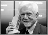


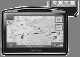
3 Our Focus Today Cell phones Networks and how they work Cell site location information (CSLI) Beepers Global Positioning System (GPS) Digital Cameras 7 Processes Cellular network triangulation GPS trilateration Geotagging 8 From bricks to smartphones 9 3


4 Statistics Over 5.7 billion cell phones worldwide 327 million in US (103% of population) 1.6 billion smartphones sold in Most Towers Tri-directional


5 Cellular network Cellular Networks 15 5


6


 kept")


7 19 Cell Site Location Information Mobile switching centers may retain location information in call detail records at least for a period of time (e.g., 24 hours) Authorities can track subscriber s general movements by following sequence of towers contacted by the phone May also obtain last recorded location before signal or power lost 20 Cell Site Location Information Most useful location information comes from initiation or receipt of a call or text Call data record (CDR) kept for billing purposes Yields historical account of cell phone s locations Officers may also locate phone in real time while a call is in progress 21 7


8 Enhanced FCC mandate of 95% of phones Locate phone location within 300 meters Within 6 minutes 22 Smartphones GPS (discussed in next Section) 23 There s an App for that 24 8
9 Smartphones Therefore, cell phones contain lots of data: Messages Voic s s Pictures & Video Location, trip data Contacts However, some of this information may not be on the phone 25 Beepers 26 Beepers Requires tailing Antenna used to track radio signals Up to 5 miles Placed on car or package 1 x2 to 3 x5 Does not store information 27 9
10 Beepers Use beeps and/or lights to indicate: Direction (but not very well) Distance 28 GPS 29 GPS Global Positioning System Developed by US government for military purposes Cost unknown, but EU s competing system expected to cost around $25 billion Still operated by the military 30 10


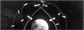


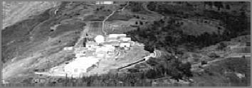
11 GPS: three components 1. Satellites 32 Earth-orbiting solar-powered satellites Each knows its distance from the center of the Earth 2. Ground Stations 11 around the globe 3. Receivers Calculate their distance from satellite 31 GPS Satellites 32 GPS Ground Stations 33 11


12 GPS receivers 34 2-D Trilateration Involves a series of difficult calculations Instead of learning that, let s use pictures 35 2-D Trilateration Detroit 366 miles 36 12


13 2-D Trilateration Detroit 312 miles Richmond 37 2-D Trilateration Detroit Charleston 388 miles Richmond Nashville 38 3-D Trilateration 39 13


14 3-D Trilateration 40 3-D Trilateration 41 3-D Trilateration 42 14
15 3-D Trilateration 43 GPS Accuracy is limited by: Earth s atmosphere Weather generally has no effect But doesn t work underwater Structures, Terrain, Foliage Clock errors Gravitational effect on satellite orbits 44 GPS Generally, accurate to 15 meters Receivers use Differential GPS to calculate error Makes measurement accurate to 10 meters, but possibly up to 10 centimeters 45 15
16 Assisted GPS (A-GPS) Uses an assistance server to more rapidly or accurately obtain a location Can be used in lieu of a fully functional GPS receiver or can be used to enhance accuracy of a location If the GPS receiver has trouble determining a location, A-GPS can make a connection using cell network to send data 46 Assisted GPS (A-GPS) Many cell phones use A-GPS, cell site triangulation and other technology to determine location Other benefits Uses less battery power Less time to get a fix Better coverage System can be upgraded at network level 47 Assisted GPS (A-GPS) Satellites Phone Company s Receiver Cell Towers Smartphone A-GPS Server 48 16


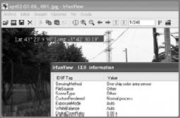
17 GPS Data Data that may be located on the GPS receiver includes: Device information Deleted locations Owner information Last fix Waypoints Routes/Journeys Home location Track logs Points of interest (POI) Favorites 49 Digital Cameras Pictures and video Geotagging Especially in smartphones 50 Geotagging Adds latitude and longitude coordinates to pictures and video Stored in metadata; not visible in the image Usually derived from GPS Camera must have a built-in in GPS receiver Can also be used with text messages, social networking updates, and blog posts 51 17


18 Geotagging 52 Convergence 53 Presented by Priscilla Grantham Senior Research Counsel, NCJRL
Mobile Devices. Objectives. Types of Devices 4/25/2012
 Mobile Devices Objectives Identify mobile devices Learn how mobile devices obtain and transmit information Identify potential evidence that may be obtained from mobile devices Learn where data is stored
Mobile Devices. Questions. NCJRL ICAC Webinar Mobile Devices October 25, Don Mason Associate Director, NCJRL. Presenter
 Mobile Devices Presenter Don Mason Associate Director, NCJRL 662-915-6898 drmason@olemiss.edu Questions Feel free to email any time to: drmason@olemiss.edu Please include your phone number In case it might
Inside vs. Outside. Inside the Box What the computer owner actually has possession of 1/18/2011
 Outside the Box: Networks and The Internet Don Mason Associate Director Copyright 2011 National Center for Justice and the Rule of Law All Rights Reserved Inside vs. Outside Inside the Box What the computer
Location, Location, Location
 Location, Location, Location Larry Rudolph 1 Outline Positioning Technology GPS and others Location Specifiers Privacy Issues Universal Location On earth, we need three piece of information: latitude,
WELCOME Mobile Applications Testing. Copyright
 WELCOME Mobile Applications Testing 1 Mobile Applications Testing List of MUST HAVE to survive this class Required Google Drive account Google email Flash Drive Mobile Phone (iphone/android) Desired Have
LOCATION DATA. Location information from mobile devices is typically obtained using the following:
 LOCATION DATA Location information from mobile devices is typically obtained using the following: 1. Cell PING (Triangulation) 2. Stingray device 3. Wi-Fi, Bluetooth tracking 4. Apps and Web browsing 5.
(Geo)Location, Location, Location.!! Matt Blaze University of Pennsylvania
Location, Location, Location.!! Matt Blaze University of Pennsylvania") (Geo)Location, Location, Location!! Matt Blaze University of Pennsylvania Mobile Devices Computers, but you carry them with you they have lots of sensors (GPS, etc) they transmit (cell, wifi, bluetooth,
(Geo)Location, Location, Location!! Matt Blaze University of Pennsylvania Mobile Devices Computers, but you carry them with you they have lots of sensors (GPS, etc) they transmit (cell, wifi, bluetooth,
BT-Q1000XT Quick Installation Guide
 GPS Travel Recorder English BT-Q1000XT Quick Installation Guide A. Standard Package (1) GPS Unit BT-Q1000XT (2) Lithium-ION Rechargeable Battery (3) Cigarette Adapter (4) mini USB Cable (5) Warranty Card
GPS for Scouts LEAD 2018
 GPS for Scouts LEAD 2018 Steve von Ehrenkrook steve@cjsassociates.com 1 Introductions Steve von Ehrenkrook Geographer Cartographer Scoutmaster Orienterrerrerr 2 MOST Important Goal as Scouters? SAFETY!!
LOXCEL CELLULAR SERVICES (Canada, Australia & New Zealand) Loxcel Geomatics loxcel.com
 Loxcel Geomatics loxcel.com") LOXCEL CELLULAR SERVICES (Canada, Australia & New Zealand) Loxcel Geomatics sales @ loxcel.com In a Nutshell Do you work with Cellular or WISP networks in Canada, Australia or New Zealand? Loxcel Cellular
LOXCEL CELLULAR SERVICES (Canada, Australia & New Zealand) Loxcel Geomatics sales @ loxcel.com In a Nutshell Do you work with Cellular or WISP networks in Canada, Australia or New Zealand? Loxcel Cellular
MOBILE COMPUTING 2/11/18. Location-based Services: Definition. Convergence of Technologies LBS. CSE 40814/60814 Spring 2018
 MOBILE COMPUTING CSE 40814/60814 Spring 2018 Location-based Services: Definition LBS: A certain service that is offered to the users based on their locations. Convergence of Technologies GIS/ Spatial Database
Annual Meeting of Stockholders. May 16, 2017
 Annual Meeting of Stockholders May 16, 2017 Safe Harbor Language This presentation contains certain statements that are forward-looking statements within the meaning of the Private Securities Litigation
Outside the Box: Networks and The Internet
 Outside the Box: Networks and The Internet Don Mason Associate Director Copyright 2011 National Center for Justice and the Rule of Law All Rights Reserved Inside vs. Outside Inside the Box What the computer
LOXCEL CELLULAR SERVICES (Canada, Australia & New Zealand) Loxcel Geomatics loxcel.com
 Loxcel Geomatics loxcel.com") LOXCEL CELLULAR SERVICES (Canada, Australia & New Zealand) Loxcel Geomatics sales @ loxcel.com In a Nutshell Do you work with Cellular or Fixed Wireless networks in Canada, Australia or New Zealand? Loxcel
LOXCEL CELLULAR SERVICES (Canada, Australia & New Zealand) Loxcel Geomatics sales @ loxcel.com In a Nutshell Do you work with Cellular or Fixed Wireless networks in Canada, Australia or New Zealand? Loxcel
Satellite Services Regulatory Issues and Broadband Internet. Note: Please ask Questions Anytime!
 Satellite Services Regulatory Issues and Broadband Internet Note: Please ask Questions Anytime! Presenter: E. Kasule Musisi ITSO Consultant Email: kasule@datafundi.co.ug Cell: +256 772 783 784 Skype: ekasule
Wireless# Guide to Wireless Communications. Objectives
 Wireless# Guide to Wireless Communications Chapter 1 Introduction to Wireless Communications Jorge Olenewa jolenewa@georgebrown.ca Office: E425 ext. 6809 Objectives Explain how the major wireless technologies
Welcome! Presented by Paul Pearson National Corvette Museum, August 28, 2014
 Welcome! Presented by Paul Pearson National Corvette Museum, August 28, 2014 Linking IP to Driver Mode Selector If your car IP gauges don t change when you turn the driver mode selector, you just need
SYNOPSIS FOR GSM AND GPS BASED VEHICLE SPEED MONITORING AND CONTROL SYSTEM
 SYNOPSIS FOR GSM AND GPS BASED VEHICLE SPEED MONITORING AND CONTROL SYSTEM Introduction We know that demand for automobile has been increased traffic and thereby causing more accidents on the road. Major
WIRELESS BROADBAND Supplemental Broadband Solution
 WIRELESS BROADBAND Supplemental Broadband Solution Our Public Power: The Next Generation April 3, 2017 NO BOARD ACTION REQUESTED WHY ARE WE HERE? Follow-up on our 2015 Strategic Planning recommendation
Making your farm a modern, connected workplace
 Making your farm a modern, connected workplace IAN WARE SEPTEMBER 2016 Why adopt new technology? Improve efficiency and profit with time and labour savings Improvements in Water use efficiency Increases
Call Detail Records The Evidence 10/19/2017. Locating Cell Phones
 Cell Phone Location Evidence for Legal Professionals Larry Daniel DFCP, EnCE, ACE, AME, BCE, CTNS, CTA, CWA Locating Cell Phones Least Precise to Most Call Detail Records (Drive Testing) Google Location
Computers Are Your Future Tenth Edition
 Computers Are Your Future Tenth Edition Chapter 3: Wired & Wireless Communication Copyright 2009 Pearson Education, Inc. Publishing as Prentice Hall 1 All rights reserved. No part of this publication may
Strengthening connections today, while building for tomorrow.
 Strengthening connections today, while building for tomorrow. Bringing you the connectivity you want, when you want it. People everywhere are using connected devices for nearly everything. On average,
ExakTime Mobile for iphone
 ExakTime Mobile for iphone Guide to Getting Started Contents Chapter 1. Introduction... 1 What s Needed to Start?... 1 Chapter 2. Configure TimeSummit... 2 Enter your Serial Numbers... 3 Set up Employees
Global Tracking. Personal Tracker and Messenger Connect with Your Workers Anywhere in the World
 Global Tracking Personal Tracker and Messenger Connect with Your Workers Anywhere in the World Connect With Your Workers Anywhere in the World. When the safety of your personnel is at stake especially
Sally Ride EarthKAM Earth Knowledge Acquired by Middle School Students
 Sally Ride EarthKAM Earth Knowledge Acquired by Middle School Students User Guide Last updated:10/20/2015 1 Table of Contents Welcome to Sally Ride EarthKAM@Space Camp!...3 Using Your Teacher Account...4-6
1. Select your preferred language, then tap to confirm your selection. Later you can change it in Regional settings.
 Initial set-up 1. Select your preferred language, then tap to confirm your selection. Later you can change it in Regional settings. 2. Read the End User Licence Agreement, and tap if you agree with the
Gathering and Using Cell Phone and Location Evidence in Criminal Cases Supplemental Materials
 Gathering and Using Cell Phone and Location Evidence in Criminal Cases Supplemental Materials 1. Definitions of Some Key Terms 2. Historical Cell-Site Location Information Subpoena Example 3. Non-Disclosure
GLOSSARY OF CELLUAR TERMS
 GLOSSARY OF CELLUAR TERMS Air Interface: It is the operating system of a wireless network.. Airtime: The amount of time a person spends talking on their cellular device. AMPS: Advanced mobile phone service
GPS Essentials. This guide may be downloaded as gps-essentials_en.odt or gps-essentials_en.pdf Reviewed
 GPS Essentials GPS Essentials This guide may be downloaded as gps-essentials_en.odt or gps-essentials_en.pdf Reviewed 2015-05-24 Installation of GPS Essentials 1. Tap the Google Play Store app icon on
Real Time Animal Movement
 Real Time Animal Movement Bradley K. Smith M.Sc. Livestock Technology Specialist Livestock and Farm Business Section Livestock Research and Extension Branch Agriculture and Forestry (403) 653-5136 Office
Wireless Public Alerting
 Wireless Public Alerting 1. What is wireless public alerting? Wireless public alerting allows governments across Canada to send public safety messages directly to smartphones in a region. If there is an
Frequently Asked Questions. Nokia E71x
 Frequently Asked Questions Nokia E71x general Is the Nokia E71x a quad band device? Yes. What is the battery life of the Nokia E71x? The Nokia E71x offers up to 4.5 hours of 3G talk time*. * Talk and standby
Dealer Account Request: Needed Information Admin First/Last Name Admin Address If available, list of PROSVR device IMEIs
 PROSVR Dealer Guide How Login to and get URL a PROSVR Dealer Account Dealer account requests will be sent to: mlynch@voxxintl.com Dealer Account Request: Needed Information Admin First/Last Name Admin
Satellite Services Regulatory Issues and Broadband Internet
 Satellite Services Regulatory Issues and Broadband Internet 1 Role of Broadband According to the Director of ITU/BDT: Broadband: has become a key priority of the 21st Century, is an enabler for economic
Types of Computers. Computer Technology (S1 Obj 1-1)
") Types of Computers Computer Technology (S1 Obj 1-1) Introduction There are many different types of computers available today. They are categorized into different types depending on their size and processing
Types of Computers Computer Technology (S1 Obj 1-1) Introduction There are many different types of computers available today. They are categorized into different types depending on their size and processing
> Acoustical feedback in the form of a beep with increasing urgency with decreasing distance to an obstacle
 PARKING ASSIST TESTING THE MEASURABLE DIFFERENCE. > Creation of complex 2-dimensional objects > Online distance calculations between moving and stationary objects > Creation of Automatic Points of Interest
GPS/GIS Activities Summary
 GPS/GIS Activities Summary Group activities Outdoor activities Use of GPS receivers Use of computers Calculations Relevant to robotics Relevant to agriculture 1. Information technologies in agriculture
Tips to Choosing the Right Satellite Phones for Your Organization
 Tips to Choosing the Right Satellite Phones for Your Organization GlobaFone Satellite Phones 155 Lafayette Rd North Hampton, NH 03862 WHERE DO I START WHEN CHOOSING MY PHONES? There are several things
BEFORE USING THE APPLICATION
 5 5 APPS145 BEFORE USING THE APPLICATION BEFORE USING THE APPLICATION BEFORE USING THE APPLICATION Precautions to be aware of when using the application are shown below. In this chapter, iphone or Android
WHAT IS GEOTAGGING GOOD FOR? HOW IT WORKS
 WHAT IS GEOTAGGING GOOD FOR? Geotagging is the process of adding a location to your photos. It makes it easy to find exactly where you shot your images and it s also great for organizing your photos. The
AT&T and Small Cells. Enhancing our network to meet consumer demand today while preparing for the technologies and innovations of tomorrow.
 AT&T and Small Cells Enhancing our network to meet consumer demand today while preparing for the technologies and innovations of tomorrow. Jennifer Price AT&T External Affairs April 2017 2016 AT&T Intellectual
Chapter 3. Wired and Wireless Communication. What You Will Learn... Computers Are Your Future. What You Will Learn...
 What You Will Learn... Computers Are Your Future Chapter 3 The definition of bandwidth The bandwidth needs of a typical user How modems change digital signals into analog Transmission media and methods
[Mule, 4(2), February, 2017] ISSN: IMPACT FACTOR
![[Mule, 4(2), February, 2017] ISSN: IMPACT FACTOR](/thumbs/74/70241684.jpg "[Mule, 4(2), February, 2017] ISSN: IMPACT FACTOR") SOLDIER TRACKING AND HEALTH MONITORING SYSTEM USING GSM OR GPS. Ketan Mule* 1, Yogesh Shelar 2 & Sanket Bhalerao 3 *1, 2,&3 Research Scholar, Department of Electronics & Telecommunication Engineering,
SOLDIER TRACKING AND HEALTH MONITORING SYSTEM USING GSM OR GPS. Ketan Mule* 1, Yogesh Shelar 2 & Sanket Bhalerao 3 *1, 2,&3 Research Scholar, Department of Electronics & Telecommunication Engineering,
Accelerating solutions for highway safety, renewal, reliability, and capacity. Connected Vehicles and the Future of Transportation
 Accelerating solutions for highway safety, renewal, reliability, and capacity Regional Operations Forums Connected Vehicles and the Future of Transportation ti Session Overview What are connected and automated
Geotagging your images.
 Geotagging your images http://goo.gl/ybryr Where was this taken? Where was this taken? Why Geocode your images Organize images better, keep track of where you ve been Better way to show your images Remembers
MOBILE LOCATION-BASED SERVICES
 MOBILE LOCATION-BASED SERVICES SUMMARY Summary Executive summary Mobile location-based services (LBS) are gradually achieving mainstream market acceptance. Popular service categories include mapping and
SHARPENING THE EDGE ON COMMUNICATION
 THRANE & THRANE EXPLORER 700 SHARPENING THE EDGE ON COMMUNICATION A cutting-edge robust broadband solution now connects all corners of the world. FACE TO FACE WITHIN SECONDS Broadband is an integral and
Off Road Navigation and Location-Based Photomarking & Blogging. 8/4/2005 The Best GPS is the one you have with you 1
 Off Road Navigation and Location-Based Photomarking & Blogging 8/4/2005 The Best GPS is the one you have with you 1 Always active Never lost, Trimble Outdoors TM The BEST GPS is the one you have with you
Add Maps With its microsd card slot and 1.7 GB of internal memory, etrex 30 lets you load maps.
 Garmin etrex 30 etrex 30 takes one of the most popular and reliable GPS handhelds and makes it better. Enhanced ergomics, an improved interface, paperless geocaching and expanded mapping capabilities makes
How are you able to get unlimited range?
 User Guide 1 System Overview: Tell me about the New Quick Track Omni. The Quick Track OMNI system takes tracking to the next generation with unlimited range capability and an interactive app designed for
Wireless and Mobile Networks Reading: Sections 2.8 and 4.2.5
 Wireless and Mobile Networks Reading: Sections 2.8 and 4.2.5 Acknowledgments: Lecture slides are from Computer networks course thought by Jennifer Rexford at Princeton University. When slides are obtained
Major features Support multi-language Automatically match photo and GPS tracks by time synchronization. Add photo comments.
 Users Manual V1.1 Users Manual Major features Read GPS log from device Add Photo and photo management Auto match photo and waypoints in tracks Shift photo time View in Google earth Save as kmz file GeoTag
Tech & Space: A Symbiotic Relationship. Rich Goldman Vice President
 Tech & Space: A Symbiotic Relationship Rich Goldman Vice President Birth of the Industries 1940s & 1950s An IBM 360 mainframe in the early 60s was 5x more powerful than the Sputnik ground guidance computers
User Guide. GeoManager Pocket Edition. March 2013
 User Guide GeoManager Pocket Edition March 2013 GeoManager Pocket Edition Administration Guide www.trimble.com/fsm Copyright 2013, Trimble Navigation Limited. All rights reserved. Trimble and the Globe
itrail Convoy (Global) User s Manual
 User s Manual") itrail Convoy (Global) User s Manual 1 What s Inside 1. Wiring Harness 2. Antenna 3. itrail Convoy Base Device 4. Serial Number (Located on the box and device) 1 2 2 3 4 3 itrail Convoy Wiring Diagram
itrail Convoy (Global) User s Manual 1 What s Inside 1. Wiring Harness 2. Antenna 3. itrail Convoy Base Device 4. Serial Number (Located on the box and device) 1 2 2 3 4 3 itrail Convoy Wiring Diagram
Cell Catcher CC1900 3G Target Identifier + IMSI Catcher + Phone Tracking
 The Cell Catcher model CC1900 tracks criminal cell phones on location, through UMTS networks, collecting and analyzing surveillance data of IMSI and IMEI numbers. 3G UMTS Gateway Technologies The Cell
CHAPTER 1 INTRODUCTION
 CHAPTER 1 INTRODUCTION These slides are made available to faculty in PowerPoint form. Slides can be freely added, modified, and deleted to suit student needs. They represent substantial work on the part
WEBINAR. Web Browsing 101 1/12/2012 WEBINAR TIPS:
 Browsing 101 WEBINAR TIPS: 1. Power off cell phones. 2. If accessing webinar through telephone, turn down volume of computer speakers (or mute them.) 3. Conference attendees will be muted during webinar
TripMate852. User s Manual
 TripMate852 User s Manual Published on 5-Auguest-2010 Note and Warning - TripMate852 uses AAA battery*2. If TripMate852 is used in temperature lower than -10 C or higher than 60 C, the battery capability
VCalm S-12. Speed Feedback Radar Sign
 VCalm S-12 Strongest Overall: 24"(W) x 30"(H) x 3.625"(D) Numerals: 12"(H) Less than 30 lbs VCalm S-16 Strongest Overall: 30"(W) x 36"(H) x 3.625"(D) Numerals: 16"(H) Less than 32 lbs VCalm S-18 Strongest
Removing Economical Constraints of Rural Deployments with RAN hardware Innovation
 Removing Economical Constraints of Rural Deployments with RAN hardware Innovation Connecting the Unconnected Today and Tomorrow The Digital Divide The digital divide = 3.7 billion* people unconnected worldwide
+50,000 Archived GCPs. The Most Comprehensive Ground Control Points Solution. Make Geospatial Data More Accurate
 The Most Comprehensive Ground Control Points Solution Make Geospatial Data More Accurate +50,000 Archived GCPs www.compassdatainc.com +1 (303) 627-4058 solutions@compassdatainc.com HOW GCPs Are Created?
House Republican Policy Committee. April 5, 2018
 Testimony of: before the House Republican Policy Committee April 5, 2018 Frank P. Buzydlowski Director, State Government Relations 717.777.5858 F.P.Buzydlowski@Verizon.com Good morning, Chairman Benninghoff
GL300 START GUIDE. To activate your account and device:
 GL300 START GUIDE Before using our products or installing a device, carefully read our legal terms which you can find at http://us.americaloc.com/legal_info.html. To activate your account and device: 1.
MOTHER TERESA SR. SEC. CO-ED SCHOOL. CLASS VIII (Comp Sc.) CHAPTER-1 : ABOUT NETWORKING
 CHAPTER-1 : ABOUT NETWORKING") Q1. Multiple Choice Questions MOTHER TERESA SR. SEC. CO-ED SCHOOL 1) WLAN stands for : CLASS VIII (Comp Sc.) 2017-18 CHAPTER-1 : ABOUT NETWORKING a) Wide Local Area Network b) World Local Area Network
Q1. Multiple Choice Questions MOTHER TERESA SR. SEC. CO-ED SCHOOL 1) WLAN stands for : CLASS VIII (Comp Sc.) 2017-18 CHAPTER-1 : ABOUT NETWORKING a) Wide Local Area Network b) World Local Area Network
Twelfth Edition. Chapter 8: Wired and Wireless Communication. Copyright 2012 Pearson Education, Inc. Publishing as Prentice Hall 1
 Computers Are Your Future Twelfth Edition Chapter 8: Wired and Wireless Communication Copyright 2012 Pearson Education, Inc. Publishing as Prentice Hall 1 Wired and Wireless Communication Copyright 2012
7 Android Cabbie s Mate - Trouble shooting and Previously Asked Questions
 7 Android Cabbie s Mate - Trouble shooting and Previously Asked Questions INDEX CHARGING ISSUES: 1- Device doesn t switch on 2- Device is not charging 3- Device is not holding charge 4- Device battery
GNSS/GPS Overview for the DEP Status and Trend Networks
 GNSS/GPS Overview for the DEP Status and Trend Networks Florida Department of Environmental Protection Tom Biernacki Video of this presentation is posted at https://fldeploc.dep.state.fl.us/appdata/status/sol
TripMate852. User s Manual
 TripMate852 User s Manual Published on 17-July-2009 Note and Warning - TripMate852 uses AAA battery*2. If TripMate852 is used in temperature lower than -10 C or higher than 60 C, the battery capability
CERBERUS it just works. cerberus.briartek.com
 CERBERUS it just works cerberus.briartek.com Introducing Cerberus Adventurers, meet your new best friend. As its legendary name suggests, Cerberus is a three-part system that will protect you just as the
ENTUNE AUDIO. - Audio System - Bluetooth Functions - Entune App Suite - Integrated Navigation ENTUNE SYSTEM QUICK REFERENCE GUIDE
 2 0 1 9 ENTUNE AUDIO - Audio System - Bluetooth Functions - Entune App Suite - Integrated Navigation ENTUNE SYSTEM QUICK REFERENCE GUIDE TABLE OF CONTENTS OVERVIEW 2 LIMITATIONS OF THE QUICK REFERENCE
President of X DOT, Inc. NSMA 2014 Conference
 Coordinate Inaccuracies Presented by James C. Wolfson President of X DOT, Inc. NSMA 2014 Conference Introduction Review FCC/FAA coordinate and elevation requirements FAA Accuracy Codes Examples Tower site,
Mobile, Smartphones, Wi-Fi, and Apps
 Mobile, Smartphones, Wi-Fi, and Apps What Are We Talking About Today? 1. Mobile 2. Different Needs 3. Geolocation & Georeference 4. Mobile-Friendliness 5. Location-Based Services 6. Wi-Fi 7. Apps vs. Websites
Setting up a GPS Unit and Basic GPS Mapping Techniques Manual
 Setting up a GPS Unit and Basic GPS Mapping Techniques Manual 1 Introduction This manual is intended to provide users with a basic understanding of a Garmin etrex GPS receiver and how it can help to support
Trimble Positioning for Automotive Applications
 Trimble Positioning for Automotive Applications Trimble at a Glance Core Markets Agriculture Construction Building Construction Geospatial Transportation Emerging Markets Automotive Rail A MARKET LEADER
MAKING BUSINESSES SMARTER AND SIMPLER MONITORING MORE EFFECTIVELY REAPING THE BENEFITS OF IOT CONNECTIVITY
 MAKING BUSINESSES SMARTER AND SIMPLER MONITORING MORE EFFECTIVELY REAPING THE BENEFITS OF IOT CONNECTIVITY INTERNET OF THINGS (IOT): THE NEXT MAJOR TECH DISRUPTOR BIGGER THAN SMARTPHONES CONNECTING EVERYTHING
AGRICULTURE CORRECTION SERVICES
 AGRICULTURE CORRECTION SERVICES NEW! CENterPoint RTX The new Trimble CenterPoint RTX Correction Service delivers GNSS enabled, repeatable 1.5-inch (4 cm) corrections to your receiver anywhere in the world.
PRIME/ESSENTIAL NAVIGATION QUICK START GUIDE
 PRIME/ESSENTIAL NAVIGATION QUICK START GUIDE EN Initial set-up 1. Select your preferred language, then tap to confirm your selection. Later you can change it in Regional settings. 2. Read the End User
GPS Nothing comes close to a Cobra. Owner s Manual ENGLISH
 Owner s Manual GPS 1080 GLOBAL POSITIONING SYSTEM RECEIVER Nothing comes close to a Cobra Printed in China Part No. 480-146-P ENGLISH IMPORTANT INFORMATION Cautions and Warnings Caution: The user is responsible
SOFTWARE DEFINED RADIO PROGRAMMABLE TRANSCEIVERS FOR FEMTOCELLS
 SOFTWARE DEFINED RADIO PROGRAMMABLE TRANSCEIVERS FOR FEMTOCELLS Erik L. Org (BitWave Semiconductor, Inc., Lowell, MA, USA; erik@bitwave.com ); Russell J. Cyr (BitWave Semiconductor, Inc., Lowell, MA, USA;
Distracted Driving Enforcement in New York
 Distracted Driving Enforcement in New York Alec Slatky Government Relations Liaison, AAA Northeast Northeast Transportation Safety Conference October 25, 2017 Distracted Driving is on the Rise 90% % of
di-gps Pro L digital images GPS receiver (Built-in data Logger)
") di-gps Pro L digital images GPS receiver (Built-in data Logger) User Guide Ver 1.4 Please visit our website www.di-gps.com for the latest version of the user guide V1.4 1 Contents Introduction 3 Warning
di-gps Pro L digital images GPS receiver (Built-in data Logger) User Guide Ver 1.4 Please visit our website www.di-gps.com for the latest version of the user guide V1.4 1 Contents Introduction 3 Warning
FREQUENTLY ASKED QUESTIONS
 TITLE: Over-the-Air Software Update DOCUMENT DATE: 10-March-2017 BACKGROUND: Just like your smartphone, the Uconnect systems in FCA vehicles work best when they have the latest software available from
Driving Smarter Fleets & Better Businesses
 Driving Smarter Fleets & Better Businesses Smart Fleet, fleet telematics Tailored to Small and Medium Enterprise While most of existing fleet management solutions are developed for heavy duty vehicles,
Safety and Security in a Digital Age. South Carolina Bar Convention Family Law Section January 22, 2010
 Safety and Security in a Digital Age South Carolina Bar Convention Family Law Section January 22, 2010 Melissa F. Brown Melissa F. Brown, LLC 145 King Street, Suite 405 Charleston, SC 29401 843.722.8900
Cellular Records Review and Analysis Part 4: T-Mobile
 Cellular Records Review and Analysis Part 4: T-Mobile PATCtech Glenn K Bard, Chief Technology Officer Jim Alsup, Director PATCtech Scott Lucas, Instructor and Examiner Brian Sprinkle, Case Manager and
MileWiz - the complete guide
 MileWiz - the complete guide Introduction Each year, each country s tax agency specifies the rates for tax deductions for driving. The rules vary from country to country. MileWiz currently supports the
WEB SITE USERS GUIDE. Manual Contents
 WEB SITE USERS GUIDE Manual Contents New Account Creation... 1 Login to Your Account... 2 Billing Information... 3 Adding a Vehicle... 4 Edit Car... 4 Vehicle Access & Control... 6 GPS locating... 7 GPS
Using your Iridium Extreme with TracPlus
 1 Using your Iridium Extreme with TracPlus Using your Iridium Extreme, you can make telephone calls and send regular tracking reports as well as check-in and emergency alert messages to TracPlus from anywhere
WELCOME Mobile Applications Testing. Copyright
 WELCOME Mobile Applications Testing 1 NETWORK: WiFi ( Hotspots) A HOTSPOT is a physical location where people may obtain Internet access, typically using Wi-Fi technology, via a wireless local area network
BRx6 Sensor Calibration Using SurvCE/SurvPC
 OVERVIEW BRx6 Sensor Calibration Using SurvCE/SurvPC The BRx6 internal sensors (tilt, accelerometer and compass) must be calibrated in order to use the electronic bubble and tilted pole corrections in
Mobile Millennium Using Smartphones as Traffic Sensors
 Mobile Millennium Using Smartphones as Traffic Sensors Dan Work and Alex Bayen Systems Engineering, Civil and Environmental Engineering, UC Berkeley Intelligent Infrastructure, Center for Information Technology
Geospatial Data Collection
 Geospatial Data Collection Etienne Coetzee Regional Manager: Africa OPTRON at a glance Established in 1986, Trimble dealer since 1987 Offices(6) in Centurion, Cape Town, Somerset-West, Durban, Nairobi
CANNOCK CHASE U3A SCIENCE & TECHNOLOGY GROUP. Mobile Phone Packages, Data, Wifi, SIMs, , Internet, GSM system. May 2016
 Barry K James, PhoneSIMSsystemRevC.ppt CANNOCK CHASE U3A SCIENCE & TECHNOLOGY GROUP Mobile Phone Packages, Data, Wifi, SIMs, Email, Internet, GSM system May 2016 A POTTED HISTORY Radio Telephones (in-car)
Chapter 6 The Internet
 Chapter The Internet Computer Concepts 2014 Chapter Contents Section A: Internet Technology Section B: Fixed Internet Access Section C: Portable and Mobile Internet Access Section D: Internet Services
GSM-R: expanding the applications
 GSM-R: expanding the applications Giovanni Guidotti, Philippe Branly 1 GSM-R evolution GSM-R initially designed for voice and signalling traffic GSM-R: not a substitute for some products, but a powerful
Verizon Wireless Ranks Highest in Wireless Network Quality Performance in Five Regions; U.S. Cellular Ranks Highest in One Region
 J.D. Power and Associates Reports: Wireless Customers Using 4G LTE Technology-Enabled Devices Experience Fewer Problems Than Those Using 3G and Other 4G-Enabled Devices Verizon Wireless Ranks Highest in
CEO Position starts January 2012
 CEO Position starts January 2012 Peter Hirsch It is a Cell Phone (of course) It is a Video Conferencing Phone It is a Digital HD Camera (Photos and Videos) It is a MP3 Player (Music Player) It is a Digital
Planning a Wireless Network. Marco Zennaro Ermanno Pietrosemoli
 Planning a Wireless Network Marco Zennaro Ermanno Pietrosemoli Goals To understand why there is a need for planning a wireless network (or link) and how it can be performed effectively To know what kind