Publishing CitiSense Data: Privacy Concerns and Remedies
|
|
|
- Christian Garrett
- 5 years ago
- Views:
Transcription
1 Publishing CitiSense Data: Privacy Concerns and Remedies Kapil Gupta Advisor : Prof. Bill Griswold 1
2 Location Based Services Great utility of location based services data traffic control, mobility management, urban planning etc. Critical to preserve privacy of the users involved Anonymity cannot be assured by simply replacing users real identifiers with pseudonyms. This project deals with these issues for CitiSense dataset 2 CSE Dept., University of California, San Diego


3 CitiSense: Introduction Portable pollution monitoring system Real-time air quality readings on a phone 3

4 CitiSense: Introduction 4
5 CitiSense: Objective Deliver air quality estimation to individuals and public health agencies. Understand the behavior of air pollutants within urban areas. So far so good! Where is the problem? 5

6 CitiSense: Data Publishing 6

7 Solutions? Strip the location information Utility completely lost! Add noise to location data Will hurt the utility Addition is not privacy-aware Does striping user identifiers from dataset still has privacy implications? Yes!!, underlying linear relation between temporal and spatial movement of individual. 7
8 Rest of the presentation: CitiSense data overview Data preprocessing Why Steps Privacy Breaches What will an attacker do What information is compromised Location Anonymization How Utility 8
9 CitiSense: Data Overview Spatio-temporal data moving object data, trajectory data, or mobility data Readings from 30 users over a period of five weeks(jul30 - Sep7) 21.5 million readings (data points) 7 sensors 9

10 CitiSense: Visualization? If 1 marker = 1 pixel 21.5M markers => whole screen covered! 10

11 CitiSense: Visualization Millions of point Browser crashes after 600 MB of memory First try Quality Threshold Clustering? 11
12 CitiSense: Preprocessing Filter outlier/noise/speed smoothing Trip Segmentation Trajectory Smoothing Trajectory Compression Error Measure for Trajectory Compression 12
13 CitiSense: Preprocessing Filter outlier/noise/speed smoothing Trip Segmentation Trajectory Smoothing Trajectory Compression Error Measure for Trajectory Compression 13


14 CitiSense: Side Note location data => earth s coordinates Mercator projection cylindrical map projection Earth s Radius = m 14
15 CitiSense: Filtering Duplication filter Multiple sensor s leads to multiple readings with same time and location information Speed and Acceleration filter few readings indicate speed of 546km/hr with 52m/sec 2 acceleration neighboring data points need to be smoothed accordingly 15
16 CitiSense: Filtering Results Data points combined threshold of 30 seconds && No location change. speed limit of 150km/s and acceleration of 10m/s 2 16 CSE Dept., University of California, San Diego
17 17 CSE Dept., University of California, San Diego
18 CitiSense: Preprocessing Filter outlier/noise/speed smoothing Trip Segmentation Trajectory Smoothing Trajectory Compression Error Measure for Trajectory Compression 18
19 CitiSense: Trip Segmentation extract trips from Change in speed. Time gap between consecutive positions Length of the trip Values set are: 300 seconds and 100 m for and respectively. 19


20 CitiSense: Trip Segmentation 20 CSE Dept., University of California, San Diego
21 CitiSense: Preprocessing Filter outlier/noise/speed smoothing Trip Segmentation Trajectory Smoothing Trajectory Compression Error Measure for Trajectory Compression 21
22 CitiSense: Trajectory Smoothing smooth noise Apply Median filter. Although suffer from lag 22
23 CitiSense: Preprocessing Filter outlier/noise/speed smoothing Trip Segmentation Trajectory Smoothing Trajectory Compression Error Measure for Trajectory Compression 23
24 CitiSense: Trajectory Compression Error Measure: Euclidean distance 24
")
25 CitiSense: Trajectory Compression Synchronous Euclidean distance (SED) 25
26 CitiSense: Trajectory Compression Similar to line generalization problem Uniform sampling algorithm? Douglas-Peucker Curve matching Top-down time-ratio (TD-TR) GTC trajectory compression algorithm Greedy solution Uses farthest point with an approximated SED less than the given error tolerance. 26
27 CitiSense: Trajectory Compression 27
28 CitiSense: Preprocessing Summary 28

29 CitiSense: Privacy Breaches Region of Interest (ROI) Behavior Mining Predictive Query Regular Routes Mining Recognizing Travel Modes 29 CSE Dept., University of California, San Diego
30 CitiSense: Privacy Breaches Region of Interest (ROI) Behavior Mining Predictive Query Regular Routes Mining Recognizing Travel Modes 30 CSE Dept., University of California, San Diego
31 CitiSense: Region of Interest (ROI) Stops Semantically important part of a trajectory 31 CSE Dept., University of California, San Diego
32 CitiSense: Region of Interest (ROI) Algorithms: IB-SMoT (Intersection Based Stops and Moves of Trajectories) CB-SMoT (Clustering-Based Stops and Moves of Trajectories) Depends on speed variation If stops are repeated frequently => ROI User s home, office, gym location etc 32 CSE Dept., University of California, San Diego
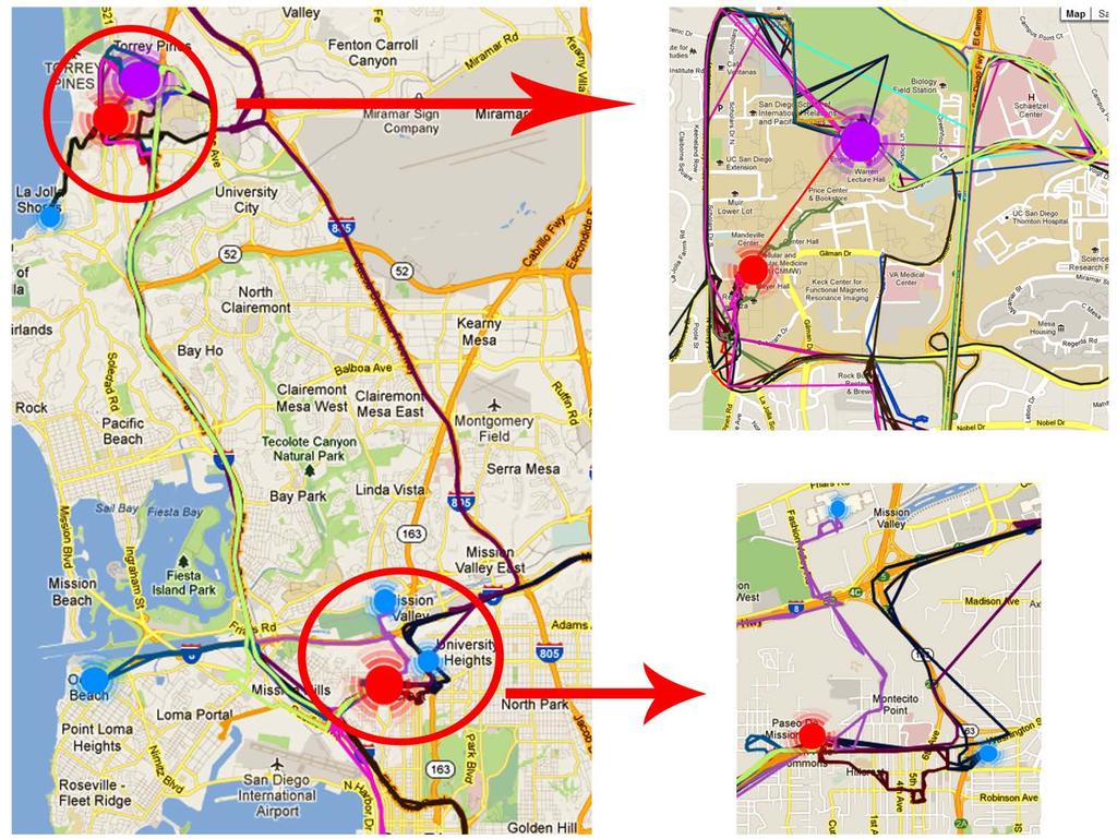
33 CitiSense: ROIs 33
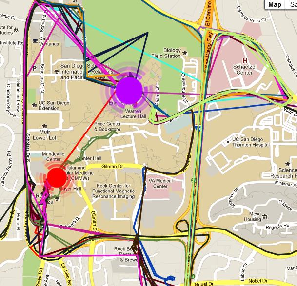
34 CitiSense: ROIs 34
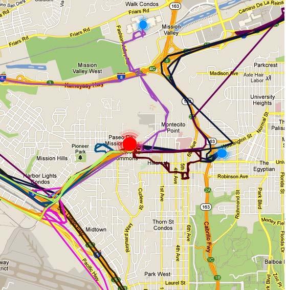
35 CitiSense: ROIs 35
36 CitiSense: Privacy Breaches Region of Interest (ROI) Behavior Mining Predictive Query Regular Routes Mining Recognizing Travel Modes 36 CSE Dept., University of California, San Diego

37 37 CSE Dept., University of California, San Diego
38 CitiSense: Privacy Breaches Region of Interest (ROI) Behavior Mining Predictive Query Regular Routes Mining Recognizing Travel Modes 38 CSE Dept., University of California, San Diego

39 39 CSE Dept., University of California, San Diego
40 CitiSense: Privacy Breaches Region of Interest (ROI) Behavior Mining Predictive Query Regular Routes Mining Recognizing Travel Modes 40 CSE Dept., University of California, San Diego
41 CitiSense: Regular Route Mining Routes Similarity Routes Grouping 41 CSE Dept., University of California, San Diego

42 CitiSense: Regular Route Mining 42 CSE Dept., University of California, San Diego
43 CitiSense: Privacy Breaches Region of Interest (ROI) Behavior Mining Predictive Query Regular Routes Mining Recognizing Travel Modes 43 CSE Dept., University of California, San Diego
44 CitiSense: Recognizing Travel Modes Walk 2-3 miles/hr 44 CSE Dept., University of California, San Diego
45 CitiSense: Recognizing Travel Modes Bike 4-5 miles/hr 45 CSE Dept., University of California, San Diego
46 CitiSense: Recognizing Travel Modes Car miles/hr 46 CSE Dept., University of California, San Diego
47 Demo 47 CSE Dept., University of California, San Diego
48 CitiSense: Trajectory Anonymization Clustering based Anonymization ROI based Anonymization Temporal Cloaking 48
49 CitiSense: Trajectory Anonymization Clustering based Anonymization ROI based Anonymization Temporal Cloaking 49
50 CitiSense: Clustering based Anonymization Also called NWA (Never Walk Alone) Based on the inherent uncertainty of GPS system Trajectory is not a line, it is cylinder utilizes the uncertainty of trajectory data to group k co-localized trajectories within the same time period to form a k-anonymized aggregate trajectory. 50

51 CitiSense: Clustering based Anonymization 51
52 CitiSense: Clustering based Anonymization 3 main steps: Pre-processing step: group all trajectories that have the same starting and ending times. Trajectories trimmed if necessary Clustering step: clusters trajectories, near by k-1 Radius is bounded by Space transformation step: arithmetic mean of the cluster See next figure. 52
53 CitiSense: Clustering based Anonymization 53
54 CitiSense: Trajectory Anonymization Clustering based Anonymization ROI based Anonymization Temporal Cloaking 54
55 CitiSense: Utility Before proceeding further, lets analyze utility of CitiSense data. Utility of CitiSense data: is not hurt by changing temporal dimension by a small amount. does not depend on number of points in database, rather number of points in different regions. 55 CSE Dept., University of California, San Diego
56 CitiSense: ROI based Anonymization Information is revealed from ROIs. Remove frequent stops from trajectory data! Simply removing stops won t work, attacker can still extrapolate. Solution: remove all points in the neighboring regions of the stops also Parameters: Avg. duration and frequency of stop to qualify, area to be removed 56
57 CitiSense: ROI based Anonymization A user trajectory on a particular day 57
58 CitiSense: ROI based Anonymization Stops in the trajectory 58
59 CitiSense: ROI based Anonymization Trajectory after removal of stops 59
60 CitiSense: ROI based Anonymization Further improvements: Semantic analysis: Tag public and private places for each user Remove private ROIs Increasing utility If privately tagged location contains more than k users. 60
61 CitiSense: Trajectory Anonymization Clustering based Anonymization ROI based Anonymization Temporal Cloaking 61
62 CitiSense: Temporal Cloaking Privacy breaches depends on successful creation of trips. Trip segmentation depends heavily on temporal pattern. Idea: Blur the users presence at a location at a particular time by inserting Gaussian noise into time linear relation between distance and time is disrupted. 62
63 CitiSense: Temporal Cloaking Introduce Gaussian noise in temporal part of the data. Small noises does not hurt the utility of the CitiSense data. 63
64 CitiSense Anonymization Results 64
65 CitiSense: Clustering based Anonymization Percentage of points anonymize by NWA is only 48% Points belong to dense region All located near CSE, UCSD k-anonymity NWA needs regions having more than 1 CitiSense user present at approximately the same time. 65 CSE Dept., University of California, San Diego

66 CitiSense: ROI Results Side Note: concentrated data point => trips=0, stops=1 66
67 CitiSense: ROI Results 67
68 CitiSense: ROI Results 68


69 CitiSense: ROI Results Table suggests anonymization leads to loss of huge data and utility. Is it the right measure? 69 CSE Dept., University of California, San Diego
70 CitiSense: ROI Results, Coverage The coverage by a data point can be defined as the area where the readings from the sensor can be considered same is the diameter of the cluster is the coverage parameter 70
71 CitiSense: Results 71
72 CitiSense: ROI Results Note: Area covered does not take into account overlapping of trajectories. Why? NWA can take care. 72
73 CitiSense: Temporal Cloaking Results Gaussian parameters (mean, sigma) are set to 600 seconds and 1 respectively. Performing preprocessing in this transformed data results in 54% less trips Points discarded as outliers. 73 CSE Dept., University of California, San Diego
74 CitiSense: Anonymization Order In what order should we apply these 3 techniques? 1. NWA 2. ROI based 3. Temporal Cloaking. Why? 74 CSE Dept., University of California, San Diego
75 CitiSense: Results Summary % of points anonymize by NWA is 48% mainly in dense regions ROI based data anonymization Protect personal information of users by compromising utility by 6%. Temporal Cloaking () => 54% less trip segmentation. Implies low data mining to extract information Ex. finding regular routes, mode of transportation 75
76 Conclusion Major privacy concern is resolved by loss of 6% loss of in utility. NWA will work better in dense data Temporal Cloaking needs more analysis. Can we find mathematical guarantees for immunity against attackers? 76

77 Questions? 77
Time Distortion Anonymization for the Publication of Mobility Data with High Utility
 Time Distortion Anonymization for the Publication of Mobility Data with High Utility Vincent Primault, Sonia Ben Mokhtar, Cédric Lauradoux and Lionel Brunie Mobility data usefulness Real-time traffic,
Mobility Data Management & Exploration
 Mobility Data Management & Exploration Ch. 07. Mobility Data Mining and Knowledge Discovery Nikos Pelekis & Yannis Theodoridis InfoLab University of Piraeus Greece infolab.cs.unipi.gr v.2014.05 Chapter
Publishing CitiSense Data: Privacy Concerns and Remedies
 University of California, San Diego Master s Project Publishing CitiSense Data: Privacy Concerns and Remedies Author: Kapil Gupta Supervisor: Prof. Bill Griswold March 15, 2013 Publishing CitiSense Data:
Contents. Part I Setting the Scene
 Contents Part I Setting the Scene 1 Introduction... 3 1.1 About Mobility Data... 3 1.1.1 Global Positioning System (GPS)... 5 1.1.2 Format of GPS Data... 6 1.1.3 Examples of Trajectory Datasets... 8 1.2
Fosca Giannotti et al,.
 Trajectory Pattern Mining Fosca Giannotti et al,. - Presented by Shuo Miao Conference on Knowledge discovery and data mining, 2007 OUTLINE 1. Motivation 2. T-Patterns: definition 3. T-Patterns: the approach(es)
DS595/CS525: Urban Network Analysis --Urban Mobility Prof. Yanhua Li
 Welcome to DS595/CS525: Urban Network Analysis --Urban Mobility Prof. Yanhua Li Time: 6:00pm 8:50pm Wednesday Location: Fuller 320 Spring 2017 2 Team assignment Finalized. (Great!) Guest Speaker 2/22 A
DS504/CS586: Big Data Analytics Data Management Prof. Yanhua Li
 Welcome to DS504/CS586: Big Data Analytics Data Management Prof. Yanhua Li Time: 6:00pm 8:50pm R Location: KH 116 Fall 2017 First Grading for Reading Assignment Weka v 6 weeks v https://weka.waikato.ac.nz/dataminingwithweka/preview
APPLICATION OF AERIAL VIDEO FOR TRAFFIC FLOW MONITORING AND MANAGEMENT
 Pitu Mirchandani, Professor, Department of Systems and Industrial Engineering Mark Hickman, Assistant Professor, Department of Civil Engineering Alejandro Angel, Graduate Researcher Dinesh Chandnani, Graduate
Privacy-Preserving of Check-in Services in MSNS Based on a Bit Matrix
 BULGARIAN ACADEMY OF SCIENCES CYBERNETICS AND INFORMATION TECHNOLOGIES Volume 15, No 2 Sofia 2015 Print ISSN: 1311-9702; Online ISSN: 1314-4081 DOI: 10.1515/cait-2015-0032 Privacy-Preserving of Check-in
Database and Knowledge-Base Systems: Data Mining. Martin Ester
 Database and Knowledge-Base Systems: Data Mining Martin Ester Simon Fraser University School of Computing Science Graduate Course Spring 2006 CMPT 843, SFU, Martin Ester, 1-06 1 Introduction [Fayyad, Piatetsky-Shapiro
TrajStore: an Adaptive Storage System for Very Large Trajectory Data Sets
 TrajStore: an Adaptive Storage System for Very Large Trajectory Data Sets Philippe Cudré-Mauroux Eugene Wu Samuel Madden Computer Science and Artificial Intelligence Laboratory Massachusetts Institute
Detecting Anomalous Trajectories and Traffic Services
 Detecting Anomalous Trajectories and Traffic Services Mazen Ismael Faculty of Information Technology, BUT Božetěchova 1/2, 66 Brno Mazen.ismael@vut.cz Abstract. Among the traffic studies; the importance
Evaluation of Privacy Preserving Algorithms Using Traffic Knowledge Based Adversary Models
 Evaluation of Privacy Preserving Algorithms Using Traffic Knowledge Based Adversary Models Zhanbo Sun, Bin Zan*, Jeff (Xuegang) Ban, Marco Gruteser* and Peng Hao Rensselaer Polytechnic Institute 110 8th
Public Sensing Using Your Mobile Phone for Crowd Sourcing
 Institute of Parallel and Distributed Systems () Universitätsstraße 38 D-70569 Stuttgart Public Sensing Using Your Mobile Phone for Crowd Sourcing 55th Photogrammetric Week September 10, 2015 Stuttgart,
A Geometric Stack for Location-Aware Networking. Marco Gruteser, Rich Martin WINLAB, Rutgers University
 A Geometric Stack for Location-Aware Networking Marco Gruteser, Rich Martin WINLAB, Rutgers University Why Location-Aware Networking? The Revenge of Geography Low-cost localization Point-of-Interest Queries
Scalable Selective Traffic Congestion Notification
 Scalable Selective Traffic Congestion Notification Győző Gidófalvi Division of Geoinformatics Deptartment of Urban Planning and Environment KTH Royal Institution of Technology, Sweden gyozo@kth.se Outline
Spatial Outlier Detection
 Spatial Outlier Detection Chang-Tien Lu Department of Computer Science Northern Virginia Center Virginia Tech Joint work with Dechang Chen, Yufeng Kou, Jiang Zhao 1 Spatial Outlier A spatial data point
Filtering and Enhancing Images
 KECE471 Computer Vision Filtering and Enhancing Images Chang-Su Kim Chapter 5, Computer Vision by Shapiro and Stockman Note: Some figures and contents in the lecture notes of Dr. Stockman are used partly.
Trajectory Data Mining: An Overview
 Trajectory Data Mining: An Overview 1 YU ZHENG Microsoft Research The advances in location-acquisition and mobile computing techniques have generated massive spatial trajectory data, which represent the
Schedule-Driven Coordination for Real-Time Traffic Control
 Schedule-Driven Coordination for Real-Time Traffic Control Xiao-Feng Xie, Stephen F. Smith, Gregory J. Barlow The Robotics Institute Carnegie Mellon University International Conference on Automated Planning
Evaluation of Seed Selection Strategies for Vehicle to Vehicle Epidemic Information Dissemination
 Evaluation of Seed Selection Strategies for Vehicle to Vehicle Epidemic Information Dissemination Richard Kershaw and Bhaskar Krishnamachari Ming Hsieh Department of Electrical Engineering, Viterbi School
OSM-SVG Converting for Open Road Simulator
 OSM-SVG Converting for Open Road Simulator Rajashree S. Sokasane, Kyungbaek Kim Department of Electronics and Computer Engineering Chonnam National University Gwangju, Republic of Korea sokasaners@gmail.com,
ACTIVITY IDENTIFICATION FROM ANIMAL GPS TRACKS WITH SPATIAL TEMPORAL CLUSTERING METHOD DDB-SMOT
 ACTIVITY IDENTIFICATION FROM ANIMAL GPS TRACKS WITH SPATIAL TEMPORAL CLUSTERING METHOD DDB-SMOT A Thesis presented to the Faculty of the Graduate School at the University of Missouri In Partial Fulfillment
Introduction to Trajectory Clustering. By YONGLI ZHANG
 Introduction to Trajectory Clustering By YONGLI ZHANG Outline 1. Problem Definition 2. Clustering Methods for Trajectory data 3. Model-based Trajectory Clustering 4. Applications 5. Conclusions 1 Problem
Mobility Data Mining. Mobility data Analysis Foundations
 Mobility Data Mining Mobility data Analysis Foundations MDA, 2015 Trajectory Clustering T-clustering Trajectories are grouped based on similarity Several possible notions of similarity Start/End points
Spatio-temporal Range Searching Over Compressed Kinetic Sensor Data. Sorelle A. Friedler Google Joint work with David M. Mount
 Spatio-temporal Range Searching Over Compressed Kinetic Sensor Data Sorelle A. Friedler Google Joint work with David M. Mount Motivation Kinetic data: data generated by moving objects Sensors collect data
Large-Scale Flight Phase identification from ADS-B Data Using Machine Learning Methods
 Large-Scale Flight Phase identification from ADS-B Data Using Methods Junzi Sun 06.2016 PhD student, ATM Control and Simulation, Aerospace Engineering Large-Scale Flight Phase identification from ADS-B
CRF Based Point Cloud Segmentation Jonathan Nation
 CRF Based Point Cloud Segmentation Jonathan Nation jsnation@stanford.edu 1. INTRODUCTION The goal of the project is to use the recently proposed fully connected conditional random field (CRF) model to
Trip Reconstruction and Transportation Mode Extraction on Low Data Rate GPS Data from Mobile Phone
 Trip Reconstruction and Transportation Mode Extraction on Low Data Rate GPS Data from Mobile Phone Apichon Witayangkurn, Teerayut Horanont, Natsumi Ono, Yoshihide Sekimoto and Ryosuke Shibasaki Institute
Differentially Private Multi- Dimensional Time Series Release for Traffic Monitoring
 DBSec 13 Differentially Private Multi- Dimensional Time Series Release for Traffic Monitoring Liyue Fan, Li Xiong, Vaidy Sunderam Department of Math & Computer Science Emory University 9/4/2013 DBSec'13:
Visual Traffic Jam Analysis based on Trajectory Data
 Visualization Workshop 13 Visual Traffic Jam Analysis based on Trajectory Data Zuchao Wang 1, Min Lu 1, Xiaoru Yuan 1, 2, Junping Zhang 3, Huub van de Wetering 4 1) Key Laboratory of Machine Perception
Privacy Protected Spatial Query Processing
 Privacy Protected Spatial Query Processing Slide 1 Topics Introduction Cloaking-based Solution Transformation-based Solution Private Information Retrieval-based Solution Slide 2 1 Motivation The proliferation
A System for Discovering Regions of Interest from Trajectory Data
 A System for Discovering Regions of Interest from Trajectory Data Muhammad Reaz Uddin, Chinya Ravishankar, and Vassilis J. Tsotras University of California, Riverside, CA, USA {uddinm,ravi,tsotras}@cs.ucr.edu
Solutions. Location-Based Services (LBS) Problem Statement. PIR Overview. Spatial K-Anonymity
 Problem Statement. PIR Overview. Spatial K-Anonymity") 2 Location-Based Services (LBS) Private Queries in Location-Based Services: Anonymizers are Not Necessary Gabriel Ghinita Panos Kalnis Ali Khoshgozaran 2 Cyrus Shahabi 2 Kian Lee Tan LBS users Mobile devices
2 Location-Based Services (LBS) Private Queries in Location-Based Services: Anonymizers are Not Necessary Gabriel Ghinita Panos Kalnis Ali Khoshgozaran 2 Cyrus Shahabi 2 Kian Lee Tan LBS users Mobile devices
Important issues. Query the Sensor Network. Challenges. Challenges. In-network network data aggregation. Distributed In-network network Storage
 Query the ensor Network Jie Gao Computer cience Department tony Brook University // Jie Gao CE9-fall Challenges Data Rich and massive data, spatially distributed. Data streaming and aging. Uncertainty,
A Framework for Trajectory Data Preprocessing for Data Mining
 A Framework for Trajectory Data Preprocessing for Data Mining Luis Otavio Alvares, Gabriel Oliveira, Vania Bogorny Instituto de Informatica Universidade Federal do Rio Grande do Sul Porto Alegre Brazil
Data Mining. Jeff M. Phillips. January 7, 2019 CS 5140 / CS 6140
 Data Mining CS 5140 / CS 6140 Jeff M. Phillips January 7, 2019 What is Data Mining? What is Data Mining? Finding structure in data? Machine learning on large data? Unsupervised learning? Large scale computational
An algorithm for Trajectories Classification
 An algorithm for Trajectories Classification Fabrizio Celli 28/08/2009 INDEX ABSTRACT... 3 APPLICATION SCENARIO... 3 CONCEPTUAL MODEL... 3 THE PROBLEM... 7 THE ALGORITHM... 8 DETAILS... 9 THE ALGORITHM
Clustering Part 4 DBSCAN
 Clustering Part 4 Dr. Sanjay Ranka Professor Computer and Information Science and Engineering University of Florida, Gainesville DBSCAN DBSCAN is a density based clustering algorithm Density = number of
Code No: R Set No. 1
 Code No: R05321204 Set No. 1 1. (a) Draw and explain the architecture for on-line analytical mining. (b) Briefly discuss the data warehouse applications. [8+8] 2. Briefly discuss the role of data cube
CrowdPath: A Framework for Next Generation Routing Services using Volunteered Geographic Information
 CrowdPath: A Framework for Next Generation Routing Services using Volunteered Geographic Information Abdeltawab M. Hendawi, Eugene Sturm, Dev Oliver, Shashi Shekhar hendawi@cs.umn.edu, sturm049@umn.edu,
Surface Creation & Analysis with 3D Analyst
 Esri International User Conference July 23 27 San Diego Convention Center Surface Creation & Analysis with 3D Analyst Khalid Duri Surface Basics Defining the surface Representation of any continuous measurement
Network Traffic Measurements and Analysis
 DEIB - Politecnico di Milano Fall, 2017 Introduction Often, we have only a set of features x = x 1, x 2,, x n, but no associated response y. Therefore we are not interested in prediction nor classification,
Research on Recognition and Classification of Moving Objects in Mixed Traffic Based on Video Detection
 Hu, Qu, Li and Wang 1 Research on Recognition and Classification of Moving Objects in Mixed Traffic Based on Video Detection Hongyu Hu (corresponding author) College of Transportation, Jilin University,
Understanding Tracking and StroMotion of Soccer Ball
 Understanding Tracking and StroMotion of Soccer Ball Nhat H. Nguyen Master Student 205 Witherspoon Hall Charlotte, NC 28223 704 656 2021 rich.uncc@gmail.com ABSTRACT Soccer requires rapid ball movements.
A STUDY ON CURRENT TRENDS IN VEHICULAR AD HOC NETWORKS
 953 A STUDY ON CURRENT TRENDS IN VEHICULAR AD HOC NETWORKS K.Prasuna 1, Chilakalapudi Meher Babu 2,K.Ram Kumar 3 1 Asst.Professor, Vijaya Institute of Technology for Women, Enikepadu, INDIA. 2 Ph.D., Scholar,
CS 229: Machine Learning Final Report Identifying Driving Behavior from Data
 CS 9: Machine Learning Final Report Identifying Driving Behavior from Data Robert F. Karol Project Suggester: Danny Goodman from MetroMile December 3th 3 Problem Description For my project, I am looking
Efficient Orienteering-Route Search over Uncertain Spatial Datasets
 Efficient Orienteering-Route Search over Uncertain Spatial Datasets Mr. Nir DOLEV, Israel Dr. Yaron KANZA, Israel Prof. Yerach DOYTSHER, Israel 1 Route Search A standard search engine on the WWW returns
IEEE networking projects
 IEEE 2018-18 networking projects An Enhanced Available Bandwidth Estimation technique for an End-to-End Network Path. This paper presents a unique probing scheme, a rate adjustment algorithm, and a modified
University of Florida CISE department Gator Engineering. Clustering Part 5
 Clustering Part 5 Dr. Sanjay Ranka Professor Computer and Information Science and Engineering University of Florida, Gainesville SNN Approach to Clustering Ordinary distance measures have problems Euclidean
A Review on Privacy Preserving Data Mining Approaches
 A Review on Privacy Preserving Data Mining Approaches Anu Thomas Asst.Prof. Computer Science & Engineering Department DJMIT,Mogar,Anand Gujarat Technological University Anu.thomas@djmit.ac.in Jimesh Rana
Introduction to Indexing R-trees. Hong Kong University of Science and Technology
 Introduction to Indexing R-trees Dimitris Papadias Hong Kong University of Science and Technology 1 Introduction to Indexing 1. Assume that you work in a government office, and you maintain the records
Activity-Based Human Mobility Patterns Inferred from Mobile Phone Data: A Case Study of Singapore
 Activity-Based Human Mobility Patterns Inferred from Mobile Phone Data: A Case Study of Singapore By: Shan Jiang, Joseph Ferreira, Jr., and Marta C. Gonzalez Published in: 2017 Presented by: Masijia Qiu
Detection of Missing Values from Big Data of Self Adaptive Energy Systems
 Detection of Missing Values from Big Data of Self Adaptive Energy Systems MVD tool detect missing values in timeseries energy data Muhammad Nabeel Computer Science Department, SST University of Management
CS4445 Data Mining and Knowledge Discovery in Databases. A Term 2008 Exam 2 October 14, 2008
 CS4445 Data Mining and Knowledge Discovery in Databases. A Term 2008 Exam 2 October 14, 2008 Prof. Carolina Ruiz Department of Computer Science Worcester Polytechnic Institute NAME: Prof. Ruiz Problem
Trajectory Compression under Network constraints
 Trajectory Compression under Network constraints Georgios Kellaris University of Piraeus, Greece Phone: (+30) 6942659820 user83@tellas.gr 1. Introduction The trajectory of a moving object can be described
Horizontal Aggregations for Mining Relational Databases
 Horizontal Aggregations for Mining Relational Databases Dontu.Jagannadh, T.Gayathri, M.V.S.S Nagendranadh. Department of CSE Sasi Institute of Technology And Engineering,Tadepalligudem, Andhrapradesh,
Tuning an Algorithm for Identifying and Tracking Cells
 Tuning an Algorithm for Identifying and Tracking Cells VA L L I A P PA L A K S H M A N A N N AT I O N A L S E V E R E S T O R M S L A B O R AT O R Y / U N I V E R S I T Y O F O K L A H O M A J U LY, 2
A method for depth-based hand tracing
 A method for depth-based hand tracing Khoa Ha University of Maryland, College Park khoaha@umd.edu Abstract An algorithm for natural human-computer interaction via in-air drawing is detailed. We discuss
Viscous Fingers: A topological Visual Analytic Approach
 Viscous Fingers: A topological Visual Analytic Approach Jonas Lukasczyk University of Kaiserslautern Germany Bernd Hamann University of California Davis, U.S.A. Garrett Aldrich Univeristy of California
Practical Use of ADUS for Real- Time Routing and Travel Time Prediction
 Practical Use of ADUS for Real- Time Routing and Travel Time Prediction Dr. Jaimyoung Kwon Statistics, Cal State East Bay, Hayward, CA, USA Dr. Karl Petty, Bill Morris, Eric Shieh Berkeley Transportation
M Thulasi 2 Student ( M. Tech-CSE), S V Engineering College for Women, (Affiliated to JNTU Anantapur) Tirupati, A.P, India
, S V Engineering College for Women, (Affiliated to JNTU Anantapur) Tirupati, A.P, India") Volume 4, Issue 7, July 2014 ISSN: 2277 128X International Journal of Advanced Research in Computer Science and Software Engineering Research Paper Available online at: www.ijarcsse.com Enhanced Driving
Volume 4, Issue 7, July 2014 ISSN: 2277 128X International Journal of Advanced Research in Computer Science and Software Engineering Research Paper Available online at: www.ijarcsse.com Enhanced Driving
Void main Technologies
 SNO TITLE Domain 1. A Hybrid Approach for Detecting Automated Spammers in Twitter Data mining 2. A Key-Policy Attribute-Based Temporary Keyword Search scheme for Secure Storage 3. A Lightweight Secure
Challenges in Ubiquitous Data Mining
 LIAAD-INESC Porto, University of Porto, Portugal jgama@fep.up.pt 1 2 Very-short-term Forecasting in Photovoltaic Systems 3 4 Problem Formulation: Network Data Model Querying Model Query = Q( n i=0 S i)
Analyzing Dshield Logs Using Fully Automatic Cross-Associations
 Analyzing Dshield Logs Using Fully Automatic Cross-Associations Anh Le 1 1 Donald Bren School of Information and Computer Sciences University of California, Irvine Irvine, CA, 92697, USA anh.le@uci.edu
Learning the Three Factors of a Non-overlapping Multi-camera Network Topology
 Learning the Three Factors of a Non-overlapping Multi-camera Network Topology Xiaotang Chen, Kaiqi Huang, and Tieniu Tan National Laboratory of Pattern Recognition, Institute of Automation, Chinese Academy
Location Based Advertising and Location k- Anonymity
 Location Based Advertising and Location k- Anonymity How can our location information be kept safe? Matthew Gaba Protecting Location Privacy with Personalized k-anonymity: Architecture and Algorithms Bugra
Who Cares about Others Privacy: Personalized Anonymization of Moving Object Trajectories
 Who Cares about Others Privacy: Personalized Anonymization of Moving Object Trajectories Despina Kopanaki Dept. of Informatics University of Piraeus, Greece dkopanak@unipi.gr Vasilis Theodossopoulos Dept.
University of Florida CISE department Gator Engineering. Clustering Part 4
 Clustering Part 4 Dr. Sanjay Ranka Professor Computer and Information Science and Engineering University of Florida, Gainesville DBSCAN DBSCAN is a density based clustering algorithm Density = number of
A New Perspective On Trajectory Compression Techniques
 A New Perspective On Trajectory Compression Techniques Nirvana Meratnia Department of Computer Science University of Twente P.O. Box 217, 7500 AE, Enschede The Netherlands meratnia@cs.utwente.nl Rolf A.
A Framework for Mobility Pattern Mining and Privacy- Aware Querying of Trajectory Data
 A Framework for Mobility Pattern Mining and Privacy- Aware Querying of Trajectory Data Despina Kopanaki Dept. of Informatics University of Piraeus Piraeus, Greece dkopanak@unipi.gr Nikos Pelekis Dept.
TRAJECTORY PATTERN MINING
 TRAJECTORY PATTERN MINING Fosca Giannotti, Micro Nanni, Dino Pedreschi, Martha Axiak Marco Muscat Introduction 2 Nowadays data on the spatial and temporal location is objects is available. Gps, GSM towers,
CHAPTER 7 INTEGRATION OF CLUSTERING AND ASSOCIATION RULE MINING TO MINE CUSTOMER DATA AND PREDICT SALES
 94 CHAPTER 7 INTEGRATION OF CLUSTERING AND ASSOCIATION RULE MINING TO MINE CUSTOMER DATA AND PREDICT SALES 7.1 INTRODUCTION Product Bundling and offering products to customers is a great challenge in retail
Forecasting of Road Traffic Congestion Using Weighted Density Variation Algorithm
 International Journal of Computing Science and Information Technology, 2013, Vol. 01 (01), 17-21 ISSN: 2278-9669, January 2013 (http://ijcsit.org) Forecasting of Road Traffic Congestion Using Weighted
Using GPS-enabled Cell Phones to Improve Multimodal Planning and Facilitate Travel Behavior Change
 Using GPS-enabled Cell Phones to Improve Multimodal Planning and Facilitate Travel Behavior Change Center for Urban Transportation Research (CUTR) Computer Science & Engineering (CSE) Overview Background
DETECTION AND ROBUST ESTIMATION OF CYLINDER FEATURES IN POINT CLOUDS INTRODUCTION
 DETECTION AND ROBUST ESTIMATION OF CYLINDER FEATURES IN POINT CLOUDS Yun-Ting Su James Bethel Geomatics Engineering School of Civil Engineering Purdue University 550 Stadium Mall Drive, West Lafayette,
Privacy-Preserving Assessment of Location Data Trustworthiness
 Purdue University Purdue e-pubs Cyber Center Publications Cyber Center 2011 Privacy-Preserving Assessment of Location Data Trustworthiness Chenyun Dai Fang-Yu Rao Gabriel Ghinita Elisa Bertino Purdue University,
European Network on New Sensing Technologies for Air Pollution Control and Environmental Sustainability - EuNetAir COST Action TD1105
 European Network on New Sensing Technologies for Air Pollution Control and Environmental Sustainability - EuNetAir COST Action TD1105 A Holistic Approach in the Development and Deployment of WSN-based
Mobility Models. Larissa Marinho Eglem de Oliveira. May 26th CMPE 257 Wireless Networks. (UCSC) May / 50
 May / 50") Mobility Models Larissa Marinho Eglem de Oliveira CMPE 257 Wireless Networks May 26th 2015 (UCSC) May 2015 1 / 50 1 Motivation 2 Mobility Models 3 Extracting a Mobility Model from Real User Traces 4 Self-similar
Mobility Models Larissa Marinho Eglem de Oliveira CMPE 257 Wireless Networks May 26th 2015 (UCSC) May 2015 1 / 50 1 Motivation 2 Mobility Models 3 Extracting a Mobility Model from Real User Traces 4 Self-similar
TRAFFIC INFORMATION SERVICE IN ROAD NETWORK USING MOBILE LOCATION DATA
 TRAFFIC INFORMATION SERVICE IN ROAD NETWORK USING MOBILE LOCATION DATA Katsutoshi Sugino *, Yasuo Asakura **, Takehiko Daito *, Takeshi Matsuo *** * Institute of Urban Transport Planning Co., Ltd. 1-1-11,
Compression of Trajectory Data: A Comprehensive Evaluation and New Approach
 Noname manuscript No. (will be inserted by the editor) Compression of Trajectory Data: A Comprehensive Evaluation and New Approach Jonathan Muckell Paul W. Olsen Jr. Jeong-Hyon Hwang Catherine T. Lawson
Analysis of Image and Video Using Color, Texture and Shape Features for Object Identification
 IOSR Journal of Computer Engineering (IOSR-JCE) e-issn: 2278-0661,p-ISSN: 2278-8727, Volume 16, Issue 6, Ver. VI (Nov Dec. 2014), PP 29-33 Analysis of Image and Video Using Color, Texture and Shape Features
Defining a Better Vehicle Trajectory With GMM
 Santa Clara University Department of Computer Engineering COEN 281 Data Mining Professor Ming- Hwa Wang, Ph.D Winter 2016 Defining a Better Vehicle Trajectory With GMM Christiane Gregory Abe Millan Contents
Cybercasing the Joint: On the Privacy Implications of Geo-Tagging
 Cybercasing the Joint: On the Privacy Implications of Geo-Tagging Gerald Friedland, Robin Sommer International Computer Science Institute Berkeley, CA fractor,robin@icsi.berkeley.edu What is Geotagging?
Time Handling in Programming Language
 CSE 237B Fall 2009 Time Handling in Programming Language Rajesh Gupta University of California, San Diego System Characteristics Complexity in function (and in size) Concurrent control of separate components
Co-clustering for differentially private synthetic data generation
 Co-clustering for differentially private synthetic data generation Tarek Benkhelif, Françoise Fessant, Fabrice Clérot and Guillaume Raschia January 23, 2018 Orange Labs & LS2N Journée thématique EGC &
The Role of a Context Service in a System that aims at integrating the Digital with the Real World
 The Role of a Context Service in a System that aims at integrating the Digital with the Real World Dagstuhl Seminar Ubiquitous Computing, 09.09.2001 Fritz Hohl (hohl@sony.de) Telecommunication Research
Quadstream. Algorithms for Multi-scale Polygon Generalization. Curran Kelleher December 5, 2012
 Quadstream Algorithms for Multi-scale Polygon Generalization Introduction Curran Kelleher December 5, 2012 The goal of this project is to enable the implementation of highly interactive choropleth maps
Clustering in Data Mining
 Clustering in Data Mining Classification Vs Clustering When the distribution is based on a single parameter and that parameter is known for each object, it is called classification. E.g. Children, young,
Mapping Internet Sensors with Probe Response Attacks
 Mapping Internet Sensors with Probe Response Attacks Computer Sciences Department University of Wisconsin, Madison Introduction Outline Background Example Attack Introduction to the Attack Basic Probe
Chapter 8: GPS Clustering and Analytics
 Chapter 8: GPS Clustering and Analytics Location information is crucial for analyzing sensor data and health inferences from mobile and wearable devices. For example, let us say you monitored your stress
3. Data Structures for Image Analysis L AK S H M O U. E D U
 3. Data Structures for Image Analysis L AK S H M AN @ O U. E D U Different formulations Can be advantageous to treat a spatial grid as a: Levelset Matrix Markov chain Topographic map Relational structure
A Novel Method for Activity Place Sensing Based on Behavior Pattern Mining Using Crowdsourcing Trajectory Data
 A Novel Method for Activity Place Sensing Based on Behavior Pattern Mining Using Crowdsourcing Trajectory Data Wei Yang 1, Tinghua Ai 1, Wei Lu 1, Tong Zhang 2 1 School of Resource and Environment Sciences,
Mobile Millennium Using Smartphones as Traffic Sensors
 Mobile Millennium Using Smartphones as Traffic Sensors Dan Work and Alex Bayen Systems Engineering, Civil and Environmental Engineering, UC Berkeley Intelligent Infrastructure, Center for Information Technology
Browsing the World in the Sensors Continuum. Franco Zambonelli. Motivations. all our everyday objects all our everyday environments
 Browsing the World in the Sensors Continuum Agents and Franco Zambonelli Agents and Motivations Agents and n Computer-based systems and sensors will be soon embedded in everywhere all our everyday objects
Data Structures for Moving Objects
 Data Structures for Moving Objects Pankaj K. Agarwal Department of Computer Science Duke University Geometric Data Structures S: Set of geometric objects Points, segments, polygons Ask several queries
TrajStore: an Adaptive Storage System for Very Large Trajectory Data Sets
 TrajStore: an Adaptive Storage System for Very Large Trajectory Data Sets Philippe Cudré-Mauroux Eugene Wu Samuel Madden Computer Science and Artificial Intelligence Laboratory Massachusetts Institute
AIAA ANERS Radar Trajectory Processing Technique for Merged Data Sources. April 21, 2017 Prepared by Bao Tong. Federal Aviation Administration
 AIAA ANERS 2017 Administration Radar Trajectory Processing Technique for Merged Data Sources April 21, 2017 Prepared by Bao Tong Federal 0 Aviation Administration 0 Introduction The FAA has access to multiple
CHAPTER 5 ANT-FUZZY META HEURISTIC GENETIC SENSOR NETWORK SYSTEM FOR MULTI - SINK AGGREGATED DATA TRANSMISSION
 CHAPTER 5 ANT-FUZZY META HEURISTIC GENETIC SENSOR NETWORK SYSTEM FOR MULTI - SINK AGGREGATED DATA TRANSMISSION 5.1 INTRODUCTION Generally, deployment of Wireless Sensor Network (WSN) is based on a many
TxDOT Video Analytics System User Manual
 TxDOT Video Analytics System User Manual Product 0-6432-P1 Published: August 2012 1 TxDOT VA System User Manual List of Figures... 3 1 System Overview... 4 1.1 System Structure Overview... 4 1.2 System