Stir It Up: Achieving GIS Interoperability
|
|
|
- Dominick Shields
- 5 years ago
- Views:
Transcription
1 Stir It Up: Achieving GIS Interoperability City of Tacoma, Washington, USA Mike Murnane, Community & Economic Development John Shell, Public Works 2006 ESRI International User Conference - August 9, 8:30 am, Room 30 C
2 Stir It Up - Achieving GIS Interoperability (Abstract) Achieving GIS interoperability between diverse systems can be accomplished with ArcSDE,, Oracle, and a few tricks. GIS at the City of Tacoma Washington uses a mix of desktop tools (ESRI ArcGIS, Autodesk Map, and GE Energy s Smallworld), data types (some readable to only one desktop tool), web tools (ESRI ArcIMS and Autodesk MapGuide), and numerous staff dispersed throughout several departments. High quality work is achieved with this mix, but challenges do exist. e Lack of an enterprise database appears to be the most limiting factor. f Recent use of Oracle has illustrated the potential for interoperability among users via Oracle s s spatial capabilities. By using a common database and a few maintenance tricks, productivity can increase. Individual users can keep their favorite tools while all can access the same data. This paper will discuss technical procedures, successes, and future ure direction.
3 Abstract GIS at Tacoma: 1. Numerous GIS tools 2. Numerous staff in several departments 3. Numerous data types Limiting Factor: No enterprise database Solution: A spatial database (Oracle Locater) Discussion: Procedures, successes, future
4 Current Conditions 1. Numerous GIS tools: ESRI ArcGIS 9.1 Planning ESRI ArcIMS 9.1 Planning (Internet) Autodesk Map 3D 2006 Engineering Autodesk MapGuide 6.3 Engineering (Internet) GE Smallworld 3.3 Utilities Oracle Locater 10g R2 SQL spatial queries Microsoft Access 2003 Attribute updates 2. Numerous staff in several departments: Decentralized with ~50 staff in seven departments 3. Numerous data types: Some readable to only one GIS tool Suitable for a wide range of GIS users, but Can interoperability be achieved?
5 GIS Interoperability (Definition per City of Tacoma Public Works Department) 1. Data Centric: Organized real-time geographic information 2. No Barriers: Accessible to GIS tools, databases, and web 3. Functional and Easy: No extra effort for technical/casual end-user
6 Solution - Oracle Locater Native access to spatial data advantages: 1. No conversion 2. No data loss 3. No data copies 4. No stale data
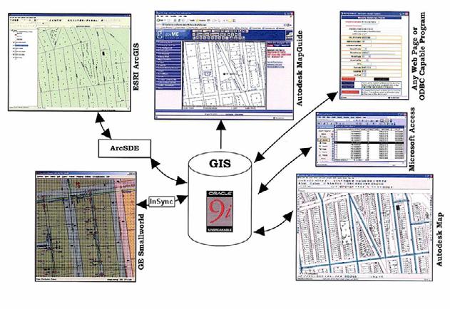
7 GIS Interoperability
8 Oracle Geometry Type SDO_Geometry: New data type, OGC-compliant Allows SQL geoprocessing: Intersect, buffer, etc ArcGIS 9.2: Access, create, update, and delete data via standard SQL to the ESRI Spatial Type for Oracle
9 Geometry Type Interoperability There is a common misconception that applications can interoperate simply because they support the same underlying geometry type. The geometry type is only one aspect of the interoperability picture a common understanding of rules, constraints, schema, and implementation is also required. ArcSDE Configuration and Tuning Guide for Oracle p.158
10 Interoperability Constraints Autodesk GE ESRI Geometry Columns Multiple Multiple or Single Single Coordinates x, y, z x, y x, y Connector Built In InSync ArcSDE Metadata Tables Yes Yes Yes Other ADMP columns - -
11 Solution to Constraints One master GIS tool per theme Oracle triggers mirroring the data One way synchronization Master Edits Data Mirrored Data Updated
12 Triggers Depend on Creator Creates Data ArcGIS Smallworld Map 3D MapGuide 3 No Trigger Needed MapGuide, Smallworld MapGuide,, ArcGIS 1 MapGuide, Smallworld Map 3D, Smallworld,, ArcGIS Trigger Needed Map 3D Map 3D, ArcGIS 1, 2 ArcGIS 2 N/A 1 Trigger needed if multiple geometry columns exist 2 An SDE View may be used instead of a trigger 3 Data created through SQL commands to a web service

13 Technical Procedures - ESRI Step 1 Export to Feature Class

14 Technical Procedures - ESRI Step 2 Set Oracle keyword
15 Technical Procedures - ESRI Step 3 - Edit Data 1. Register as Versioned (SDE copy ) 2. Edit (Area - ESRI Technical Article ID: 27329) 3. Compress Database (SDE mirror )


16 Technical Procedures - GE Step 1 - Connect

17 Technical Procedures - GE Step 2 Select tables to replicate

18 Technical Procedures - GE Step 3 Create data


19 Technical Procedures - AutoDesk Map 3D Oracle Toolbar
 to")
20 Technical Procedures - AutoDesk Export (write) to Oracle
")
21 Technical Procedures - AutoDesk Import (read) Oracle Data
22 Native access to spatial data: 1. No conversion after the conversion or initial migration 2. No data loss just hidden 3. No data copies triggers instead 4. No stale data unless there s s no time for maintenance
23 Successes Building a city-wide GIS database Seeing all data despite creation tools Users can keep their tools Immediate updates Time savings Web geoprocessing with SQL (Critical Areas, Zoning example)

24 govme government Made Easy

25 Parcel Summary SQL Intersect

26 Parcel Summary SQL Intersect Habitat Zone Percent:

27 Parcel Summary SQL Intersect Zoning Occurrence:
28 Future GIS Users Group Change procedures with software updates Eliminate triggers whenever possible Cost Sharing Agreement Policies for sharing, editing, & metadata Continue to explore options for user needs
29 Questions? Mike Murnane: John Shell:
30 Acknowledgements Special thanks to the following City of Tacoma employees for their assistance on this presentation: Gary Cantu, Public Works J.R. Smith, Public Works Mitch Webb, Public Works Ronnie Harris, Power Tom Arter, Power
31 Primary Author Information Mike Murnane Senior GIS Analyst City of Tacoma, Washington Community & Economic Development Department 747 Market Street, Room 900 Tacoma, WA / FAX mmurnane@cityoftacoma.org
FDO Data Access Technology at a Glance
 Autodesk Geospatial FDO Data Access Technology at a Glance Work seamlessly with your geospatial data whatever the format 1 The Challenge The growing need for openness and interoperability between traditional
Enterprise GIS for Managing Reservation Land
 Enterprise GIS for Managing Reservation Land Beckie Howell GIS Manager Agua Caliente Band of Cahuilla Indians ESRI UC 2014 Tribal Indigenous GIS Track Empowering Tribal Governments with Enterprise GIS
Key Terms. Attribute join Target table Join table Spatial join
 Key Terms Attribute join Target table Join table Spatial join Lect 10A Building Geodatabase Create a new file geodatabase Map x,y data Convert shape files to geodatabase feature classes Spatial Data Formats
The Oracle Enterprise Geodatabase (EGDB) Charlie Crocker Farallon Geographics, Inc.
 Charlie Crocker Farallon Geographics, Inc.") The Oracle Enterprise Geodatabase (EGDB) Charlie Crocker Farallon Geographics, Inc. www.fargeo.com Norcal URISA Chapter Meeting 2/9/2005 Todays Goals Enterprise geodatabase defined Roles Oracle can play
The Oracle Enterprise Geodatabase (EGDB) Charlie Crocker Farallon Geographics, Inc. www.fargeo.com Norcal URISA Chapter Meeting 2/9/2005 Todays Goals Enterprise geodatabase defined Roles Oracle can play
Administering Your Oracle Geodatabase. Amit Kesarwani Mandar Purohit
 Administering Your Oracle Geodatabase Amit Kesarwani Mandar Purohit Intended Audience Desktop Web Device You are.. - A geodatabase administrator - An accidental DBA - A deliberate DBA Portal Portal Server
Subject: Migration Information for ArcIMS, ArcSDE, and ArcGIS Server Users
 December 12, 2006 Subject: Migration Information for ArcIMS, ArcSDE, and ArcGIS Server Users Summary This document provides information about how we are migrating your licenses and maintenance for ESRI
ArcGIS for Server Michele Lundeen
 ArcGIS for Server 10.1 Michele Lundeen Summary Vision Installation and Configuration Architecture Publishing Functional Enhancements Cloud Migration and Best Practices Powerful GIS capabilities Delivered
Using ESRI data in Autodesk ISD Products
 GI13-3 Using ESRI data in Autodesk ISD Products 1.5 hr. Class 02-Dec-03 3:30pm - 5:00pm Session Description: We will focus on using data in a variety of ESRI formats within the Autodesk GIS product line,
ArcSDE 8.1 Questions and Answers
 ArcSDE 8.1 Questions and Answers 1. What is ArcSDE 8.1? ESRI ArcSDE software is the GIS gateway that facilitates managing spatial data in a database management system (DBMS). ArcSDE allows you to manage
Introduction to Geodatabase and Spatial Management in ArcGIS. Craig Gillgrass Esri
 Introduction to Geodatabase and Spatial Management in ArcGIS Craig Gillgrass Esri Session Path The Geodatabase - What is it? - Why use it? - What types are there? - What can I do with it? Query Layers
Administering Your Oracle Geodatabase. Jim McAbee Mandar Purohit
 Administering Your Oracle Geodatabase Jim McAbee Mandar Purohit Intended Audience Desktop Web Device You are.. - A geodatabase administrator - An accidental DBA - A deliberate DBA - Not sure what DBA means
Software and Migration Services FAQ for more information (available from Electronic Data Solutions ). Some implementation will be required, including
. Some implementation will be required, including") Sales and Marketing What is the target audience for FieldSeeker GIS for Mosquito Control? It is hoped that FieldSeeker GIS for Mosquito Control will serve the needs of small, medium, and large enterprise
Sales and Marketing What is the target audience for FieldSeeker GIS for Mosquito Control? It is hoped that FieldSeeker GIS for Mosquito Control will serve the needs of small, medium, and large enterprise
Introduction to ArcSDE 8. John Calkins
 Introduction to ArcSDE 8 John Calkins Why are you here? Introduction to ArcSDE? What is a GeoDatabase? Existing SDE user? Existing ArcInfo user? Technical details on implementation? Just confused... ArcSDE
Assimilating GIS-Based Voter Districting Processes in Maricopa County, Arizona
 Assimilating GIS-Based Voter Districting Processes in Maricopa County, Arizona Tim Johnson Geographic Information Systems Manager Maricopa County Recorder/Elections Department Abstract Accurate district
Editing Versioned Geodatabases : An Introduction
 Esri International User Conference San Diego, California Technical Workshops July 24, 2012 Editing Versioned Geodatabases : An Introduction Cheryl Cleghorn Shawn Thorne Assumptions: Basic knowledge of
ArcGIS 9: Deploying Server-Based GIS Functionality for Indianapolis/Marion County, Indiana
 ArcGIS 9: Deploying Server-Based GIS Functionality for Indianapolis/Marion County, Indiana Richard L. Petrecca, Jr. and Jonathan R. Downey This presentation focuses on ArcGIS Server and its usefulness
Integrating ArcGIS desktop in data interoperability environments with heterogeneous GIS clients
 Data-Interoperability based on Common Databases Integrating ArcGIS desktop in data interoperability environments with heterogeneous GIS clients M.Sc Abdurasyid Moestofa / Prof. Rainer Kettemann Stuttgart
Desktop. ArcGIS Server. ArcGIS
 Getting Started with ArcGIS Server Nakul Bhatia and David Crosby ESRI Charlotte 1 Agenda g Overview of ArcGIS Server 9.3.1 Working with GIS Services Using g Web GIS Service Clients ArcGIS Online Map Caching
Enterprise Geographic Information Servers. Dr David Maguire Director of Products Kevin Daugherty ESRI
 Enterprise Geographic Information Servers Dr David Maguire Director of Products Kevin Daugherty ESRI Outline Introduction Enterprise GIS vs. Spatially-enabled IS Architectures for building Enterprise GIS
Data Synchronization: Autodesk AutoCAD Map 3D Enterprise, FME, and ESRI ArcGIS
 Data Synchronization: Autodesk AutoCAD Map 3D Enterprise, FME, and ESRI ArcGIS Drew Burgasser, P.E. Vice-President, CAD Masters, Inc. Join us on Twitter: #AU2013 Class summary Sacramento Area Sewer District
ESRI Software Evolution
 ArcGIS Jan Šlahař About ESRI ESRI - Environmental Systems Research Institute Founded in 1969, Redlands, California In 2002 Esri had approximately a 36 percent share of the GIS software market worldwide
Integrating ArcGIS to Enterprise Oracle Spatial Using Direct Connect
 Integrating ArcGIS to Enterprise Oracle Spatial Using Direct Connect Michael D. Tsengouras Principal Software Engineer Navigation Technologies Corporation Abstract: Many organizations are adopting Enterprise
ESRI Technology Update. Joe Holubar Larry Young
 ESRI Technology Update Joe Holubar Larry Young Continued Improvement Improving Quality and Extending and Refining Functionality First Half of 2009: Minor Update Release (ArcGIS 9.3.1) ArcGIS Explorer Fall
Geog 469 GIS Workshop. System Requirements
 Geog 469 GIS Workshop System Requirements Outline 1. What are some fundamental issues associated with system requirements? 2. What are your GIS data requirements? 3. What are your GIS software requirements?
GEOSPATIAL ERDAS APOLLO. Your Geospatial Business System for Managing and Serving Information
 GEOSPATIAL ERDAS APOLLO Your Geospatial Business System for Managing and Serving Information ERDAS APOLLO Do you have large volumes of data, a geographicallydistributed user base and rapidly changing
VanMap Integration at the City of Vancouver. Zsigmond Balogh Meng Li Jonathan Mark
 VanMap Integration at the City of Vancouver Zsigmond Balogh Meng Li Jonathan Mark City of Vancouver December 13, 2007 Presentation Objectives Describe GIS approach at Vancouver Describe VanMap integration
Web Map Servers. Mark de Blois. Septembre 2016
 Web Map Servers Mark de Blois Septembre 2016 Learning Objectives After this lecture you will be able to understand web map servers as used in Web-GIS applications Introduction A Web Map Server is a computer
Design a Geodatabase. Rasu Muthurakku, Enterprise Solutions Architect / Consultant
 Rasu Muthurakku, Enterprise Solutions Architect / Consultant Agenda Overview Key Factors Design - Recommendations Key Considerations, Best Practices and Recommendations / Lessons Learned! Overview What
Schema transformations in mass data harmonization process. Yohann Ly 8/9 Octobre 2013 Marne la Vallée
 Schema transformations in mass data harmonization process Yohann Ly 8/9 Octobre 2013 Marne la Vallée Mass data harmonization process Problematic : Multiple data providers Multiple storage format Multiple
What s New in Desktop 10.1
 What s New in Desktop 10.1 Damian Spangrud Esri Redlands Trip Down Memory Lane ArcGIS A Complete System for Geographic Information Cloud Web Online Mobile Enterprise Desktop Sharing Information sharing
Bridging the gap between CAD and GIS for Cadastral Mapping
 Bridging the gap between CAD and GIS for Cadastral Mapping CCMA 2008 Annual Conference - Sacramento Colin Hobson Munsys, Inc Sample Customers North America Overview Munsys provides an integrated family
AutoCAD Map 3D and ESRI ArcSDE
 AUTOCAD MAP 3D 2009 WHITE PAPER AutoCAD Map 3D and ESRI ArcSDE Many organizations, such as utilities, telecommunication providers, and government agencies, depend on geospatial data that is stored in a
ArcGIS 9.2 Works as a Complete System
 ArcGIS 9.2 Works as a Complete System A New Way to Manage and Disseminate Geographic Knowledge Author/Serve/Use Maps Data Models Globes Metadata Use Desktop Explorer Web Map Viewer Mobile Open APIs Enterprise
Esri s ArcGIS Enterprise. Today s Topics. ArcGIS Enterprise. IT4GIS Keith T. Weber, GISP GIS Director ISU GIS Training and Research Center
 Esri s ArcGIS Enterprise IT4GIS Keith T. Weber, GISP GIS Director ISU GIS Training and Research Center Today s Topics Part 1: ArcGIS Enterprise architecture Part 2: Storing and serving data for the enterprise
ArcSDE architecture and connections
 ArcSDE architecture and connections Lesson overview ArcSDE system components Application Server Connections Direct Connect Geodatabase properties ArcSDE versions What is a version ArcIMS and versions 6-2
What s New in ArcGIS Server 10
 What s New in ArcGIS Server 10 Derek Law ArcGIS Server Product Management What s s new in ArcGIS Server 10? Agenda Highlights: Enhanced Web mapping More powerful server-based analysis Geo-collaboration
Esri s Spatial Database Engine. Today s Topics. ArcSDE. A spatial database engine that works on
 Esri s Spatial Database Engine IT4GIS Keith T. Weber, GISP GIS Director ISU GIS Training and Research Center Today s Topics Part 1: What is ArcSDE? Why use ArcSDE? ArcSDE Data Structure How is data stored
ArcGIS Schematics: Automatic Schematic Generation for ArcGIS
 ArcGIS Schematics: Automatic Schematic Generation for ArcGIS An ESRI White Paper May 2005 ESRI 380 New York St., Redlands, CA 92373-8100, USA TEL 909-793-2853 FAX 909-793-5953 E-MAIL info@esri.com WEB
GEOFidelis Program Update
 GEOFidelis Program Update JSEM & Geospatial Conference Columbus, OH 22 May 2007 Organization Secretary of the Navy CNO CMC GEOFidelis Program Office MCI NCR MCI East MCRD ERR MCI West MCRD WRR MCI Mid
Feature Enhancements by Release
 Autodesk Map Feature Enhancements by Release This document highlights the feature enhancements that have occurred with each release of Autodesk Map software from Release 4 (2000i) through the current 2004
Understanding ArcGIS Pipeline Referencing for Vertically Integrated Gas Companies. GeoConX 2017 September 7, 2017
 Understanding ArcGIS Pipeline Referencing for Vertically Integrated Gas Companies GeoConX 2017 September 7, 2017 The Asset Intelligence Imperative GOAL The necessity to learn ever more, in as close to
This support note will discuss several methods of creating no spray zones for Sentinel GIS>
 Reason Sentinel Adulticiding support a polygon no spray layer. Adulticiding mobile software warns the driver when they are approaching a no spray zone so they can turn off the sprayer. Because no spray
ArcGIS 9 Installation Guide: ArcSDE 64 bit for Microsoft SQL Server
 ArcGIS 9 Installation Guide: ArcSDE 64 bit for Microsoft SQL Server Copyright 2009 ESRI All Rights Reserved. Printed in the United States of America. The information contained in this document is the exclusive
Overview of Server Technologies. Katja Krivoruchko ESRI
 Overview of Server Technologies Katja Krivoruchko ESRI Agenda Introduction to Server Technology Workflow Considerations ESRI Server Technology ArcSDE ArcGIS Server ArcGIS Image Server File Server Implementation
GEOGRAPHIC INFORMATION SYSTEMS Lecture 18: Spatial Modeling
 Spatial Analysis in GIS (cont d) GEOGRAPHIC INFORMATION SYSTEMS Lecture 18: Spatial Modeling - the basic types of analysis that can be accomplished with a GIS are outlined in The Esri Guide to GIS Analysis
Locating unknown connection services during reading routes
 1 Locating unknown connection services during reading routes Introduction Canal de Isabel II was founded in 1851 to provide water to Madrid (capital of Spain). Now it provides water to 5.5 million people
ORACLE SPATIAL AT IOWA DOT. Eric Abrams Iowa Department of Transportation GIS-T 2012
 ORACLE SPATIAL AT IOWA DOT Eric Abrams Iowa Department of Transportation GIS-T 2012 HISTORY High and Low Roads to GIS Development Bijan Azad - Beirut, Lebanon 1997 1998 combine business data Road data
What s s Coming in ArcGIS 10 Desktop
 What s s Coming in ArcGIS 10 Desktop Damian Spangrud ArcGIS Product Manager, ESRI dspangrud@esri.com (or at least turn to silent) ArcGIS 10 A Simple & Pervasive System for Using Maps & Geographic Information
Army ITAM GIS: Utilizing ArcSDE and SDSFIE to Support the Enterprise
 Army ITAM GIS: Utilizing ArcSDE and SDSFIE to Support the Enterprise Gary Senseman ITAM GIS Western Regional Support, Center for Environmental Management of Military Lands, Colorado State University, Fort
Esri Support for Geospatial Standards
 APRIL 2017 ArcGIS Is Open and Interoperable Esri Support for Geospatial Standards Copyright 2017 Esri All rights reserved. Printed in the United States of America. The information contained in this document
Learning What s New in ArcGIS 10.1 for Server: Administration
 Esri Mid-Atlantic User Conference December 11-12th, 2012 Baltimore, MD Learning What s New in ArcGIS 10.1 for Server: Administration Derek Law Product Manager Esri - Redlands ArcGIS for Server Delivering
Training courses. Course Overview Details Audience Duration. Applying GIS
 Training courses (Last update: December 2017) Remarks: As part of a course a certificate is issued for each attendee. All software used during the courses is Open Source Software. Contact: allspatial Geospatial
GIS Basics for Urban Studies
 GIS Basics for Urban Studies Date: March 21, 2018 Contacts: Mehdi Aminipouri, Graduate Peer GIS Faciliator, SFU Library (maminipo@sfu.ca) Keshav Mukunda, GIS & Map Librarian Librarian for Geography (kmukunda@sfu.ca)
May 21, 2014 Walter E. Washington Convention Center Washington, DC USA. Copyright 2014, Oracle and/or its affiliates. All rights reserved.
 May 21, 2014 Walter E. Washington Convention Center Washington, DC USA 1 How to Build a Better GIS Application Siva Ravada Senior Director of Development Spatial and Graph & MapViewer Oracle Program Agenda
Kelar Corporation. Leaseline Management Application (LMA)
") Kelar Corporation Leaseline Management Application (LMA) Overview LMA is an ObjectARX application for AutoCAD Map software. It is designed to add intelligence to the space management drawings associated
Kelar Corporation Leaseline Management Application (LMA) Overview LMA is an ObjectARX application for AutoCAD Map software. It is designed to add intelligence to the space management drawings associated
San José Implementing GIS the Spatial Way. Addressing compliance, security, scalability, interoperability and open standards for business needs
 San José Implementing GIS the Spatial Way Addressing compliance, security, scalability, interoperability and open standards for business needs Overview Key Strategy & Requirements Building on Previous
DSL Target Marketing using ArcIMS. Authored By: Eric Pimpler and Eric Cabading
 DSL Target Marketing using ArcIMS Authored By: Eric Pimpler and Eric Cabading Abstract SBC Communications, Inc., is a global leader in telecommunications services, and provides a full range of voice, data,
Lab 1: Exploring ArcMap and ArcCatalog In this lab, you will explore the ArcGIS applications ArcCatalog and ArcMap. You will learn how to use
 Lab 1: Exploring ArcMap and ArcCatalog In this lab, you will explore the ArcGIS applications ArcCatalog and ArcMap. You will learn how to use ArcCatalog to find maps and data and how to display maps in
Compass INSPIRE Services. Compass INSPIRE Services. White Paper Compass Informatics Limited Block 8, Blackrock Business
 Compass INSPIRE Services White Paper 2010 Compass INSPIRE Services Compass Informatics Limited Block 8, Blackrock Business Park, Carysfort Avenue, Blackrock, County Dublin, Ireland Contact Us: +353 1 2104580
AGIC 2012 Workshop Leveraging Free RDBMS in ArcGIS
 AGIC 2012 Workshop Leveraging Free RDBMS in ArcGIS Prescott, AZ October 2012 Instructors: Bo Guo, PE, PhD Terry Li Workshop Outline Part I Introduction Why RDBMS Discussion on Obstacles for using RDBMS
Working with Metadata in ArcGIS
 Esri International User Conference San Diego, California Technical Workshops July 26, 2012 Working with Metadata in ArcGIS Aleta Vienneau Metadata in ArcGIS ArcGIS metadata goals Editing metadata Setting
The Reykjavik GIS project
 The Reykjavik GIS project Jörgen Þormóðsson - Manager of LUKR Stefán Guðlaugsson - GIS-manager of Samsýn City of Reykjavik Department of Environment and Planning Division of Geodesy and Geoinformatics
Building and Deploying Enterprise ArcGIS Server Solutions (Best Practices) Wittaker Mathot Developer Summit
 Wittaker Mathot Developer Summit") Building and Deploying Enterprise ArcGIS Server Solutions (Best Practices) Wittaker Mathot Developer Summit 2007 1 Presentation Goals See real world, Enterprise implementations of ArcGIS Server presented
Building and Deploying Enterprise ArcGIS Server Solutions (Best Practices) Wittaker Mathot Developer Summit 2007 1 Presentation Goals See real world, Enterprise implementations of ArcGIS Server presented
Basic Tasks in ArcGIS 10.3.x
 Basic Tasks in ArcGIS 10.3.x This guide provides instructions for performing a few basic tasks in ArcGIS 10.3.1, such as adding data to a map document, viewing and changing coordinate system information,
Naval I. nstallation Restoration I nformation Solution. Innovation Leadership Performance
 Naval I nstallation Restoration I nformation Solution Innovation Leadership Performance Navy's Solution for Environmental Restoration Data Management 2007 JSEM Josh Fortenberry (805) 982-4990 Naval Facilities
APPENDIX G. VMT Spreadsheet Tool. FINAL REPORT Improved Data & Tools for Integrated Land Use-Transportation Planning in California TOPICS:
 FINAL REPORT Improved Data & Tools for Integrated Land Use-Transportation Planning in California APPENDIX G VMT Spreadsheet Tool TOPICS: 1. Overview of Tool 2. Code Documentation 3. User Guide 4. Validation
Administering Your Microsoft SQL Server Geodatabase
 Esri International User Conference San Diego, California Technical Workshops July 25, 2012 Administering Your Microsoft SQL Server Geodatabase Thomas Dunn and Shannon Shields Topics for this presentation
How to Create Metadata in ArcGIS 10.0
 How to Create Metadata in ArcGIS 10.0 March 2012 Table of Contents Introduction... 1 Getting Started... 2 Software Requirements... 2 Configure ArcGIS Desktop to View FGDC Metadata... 2 Other Thoughts...
Feeding ESRI s ArcGIS Desktop with Query Tool Extensions at Anadarko Canada.
 Feeding ESRI s ArcGIS Desktop with Query Tool Extensions at Anadarko Canada. Primary Author: John Gillatt, Anadarko Secondary Author: Chuck Smith, Divestco Inc. ESRI PUG Houston March 2005 Agenda Introduction
Enterprise Architecture Deployment Options. Mark Causley Sandy Milliken Sue Martin
 Enterprise Architecture Deployment Options Mark Causley Sandy Milliken Sue Martin GIS is Being Implemented in Many Settings Organization Business to Business Department Workgroup GIS is Moving to the Enterprise
Configuring, Tuning and Managing ArcGIS Server. Dan O Leary James Cardona Owen Evans
 Configuring, Tuning and Managing ArcGIS Server Dan O Leary James Cardona Owen Evans Introductions and Overview Welcome and Thanks for Attending Approach of this Session Share Best Practices and Techniques
Spatially Enable Your DBA PUG Miles Phillips LandWorks, Inc Feb 27, 2008
 Spatially Enable Your DBA PUG 2008 Miles Phillips mphillips@landworks.com LandWorks, Inc Feb 27, 2008 Audience Experienced DBAs assigned to support ArcSDE Experienced ArcGIS users that need to understand
Best Practices for Designing Effective Map Services
 2013 Esri International User Conference July 8 12, 2013 San Diego, California Technical Workshop Best Practices for Designing Effective Map Services Ty Fitzpatrick Tanu Hoque What s in this session Map
Utility Network Management in ArcGIS: Migrating Your Data to the Utility Network. John Alsup & John Long
 Utility Network Management in ArcGIS: Migrating Your Data to the Utility Network John Alsup & John Long Presentation Outline Utility Network Preparation - Migration Patterns - Understanding the Asset Package
INSPIRE: The ESRI Vision. Tina Hahn, GIS Consultant, ESRI(UK) Miguel Paredes, GIS Consultant, ESRI(UK)
 Miguel Paredes, GIS Consultant, ESRI(UK)") INSPIRE: The ESRI Vision Tina Hahn, GIS Consultant, ESRI(UK) Miguel Paredes, GIS Consultant, ESRI(UK) Overview Who are we? Introduction to ESRI Inc. and ESRI(UK) Presenters ArcGIS The ESRI Solution to
INSPIRE: The ESRI Vision Tina Hahn, GIS Consultant, ESRI(UK) Miguel Paredes, GIS Consultant, ESRI(UK) Overview Who are we? Introduction to ESRI Inc. and ESRI(UK) Presenters ArcGIS The ESRI Solution to
ArcGIS Issues Addressed List
 ArcGIS 10.4.1 Issues Addressed List ArcGIS for Desktop (Also Contains ArcGIS Engine) Portal for ArcGIS ArcGIS Data Store Home Application ArcGIS for Server Amazon Documentation Feature Services Geocode
What Is the ArcIMS Tracking Server?
 What Is the ArcIMS Tracking Server? An ESRI White Paper May 2003 ESRI 380 New York St., Redlands, CA 92373-8100, USA TEL 909-793-2853 FAX 909-793-5953 E-MAIL info@esri.com WEB www.esri.com Copyright 2003
FDO Data Access Technology How to add new data sources with Third Party and Open Source FDO Providers
 AUTODESK GEOSPATIAL WHITE PAPER FDO Data Access Technology How to add new data sources with Third Party and Open Source FDO Providers Work seamlessly with your geospatial data whatever the format Autodesk
How to install ArcGIS for Desktop 10.1
 Welcome to ArcGIS How to install ArcGIS for Desktop 10.1 This guide will help you install ArcGIS for Desktop (Basic, Standard, Advanced). First, let s review the setup requirements that you need to consider
Accessing and Administering your Enterprise Geodatabase through SQL and Python
 Accessing and Administering your Enterprise Geodatabase through SQL and Python Brent Pierce @brent_pierce Russell Brennan @russellbrennan hashtag: #sqlpy Assumptions Basic knowledge of SQL, Python and
Bentley Systems Army Training Program Focuses on CAD GIS Integration
 Bentley Systems Army Training Program Focuses on CAD GIS Integration Tom Brown, Army Account Manager, Bentley Systems, Inc. Installations face serious challenges managing, analyzing and publishing geospatial
Creating Python Scripts for ArcGIS STUDENT EDITION
 Creating Python Scripts for ArcGIS STUDENT EDITION Copyright 2018 Esri All rights reserved. Course version 1.2. Version release date August 2018. Printed in the United States of America. The information
Best Practices with ArcSDE Technology. Katja Krivoruchko CA/NV/HI Technical Marketing ESRI
 Best Practices with ArcSDE Technology Katja Krivoruchko CA/NV/HI Technical Marketing ESRI Agenda What is ArcSDE Maintaining ArcSDE performance Geodatabase Toolset (GDBT) Upgrading ArcSDE Capacity Planning
hereby recognizes that Timotej Verbovsek has successfully completed the web course 3D Analysis of Surfaces and Features Using ArcGIS 10
 3D Analysis of Surfaces and Features Using ArcGIS 10 Completed on September 5, 2012 3D Visualization Techniques Using ArcGIS 10 Completed on November 19, 2011 Basics of Map Projections (for ArcGIS 10)
Tracking and defending changes in an ESRI Geodatabase
 Tracking and defending changes in an ESRI Geodatabase 2017 ESRI Petroleum User Group (PUG) Conference Jeff Wilcox Kinder Morgan Peter Veenstra - TRC Introduction and Overview Introductions Jeff Wilcox
Leveraging OGC Services in ArcGIS Server. Satish Sankaran, Esri Yingqi Tang, Esri
 Leveraging OGC Services in ArcGIS Server Satish Sankaran, Esri Yingqi Tang, Esri GIS Creating and Managing Geo Information Products - Proprietary - Open Specifications - Standards Dissemination of Geo
ArcMap - EXPLORING THE DATABASE Part I. SPATIAL DATA FORMATS Part II
 Week 5 ArcMap - EXPLORING THE DATABASE Part I SPATIAL DATA FORMATS Part II topics of the week Exploring the Database More on the Table of Contents Exploration tools Identify, Find, Measure, Map tips, Hyperlink,
Moving Dynamic Segmentation to the Server: Linear Referencing for Web- Based Applications
 Moving Dynamic Segmentation to the Server: Linear Referencing for Web- Based Applications Paper 6.4.2 Graham Stickler and Rob Coupe Exor Corporation Contents Why move things to the database Oracle spatial
Unity In diversity. ArcGIS JS API as an Integration Tool. RICARDO BANDEIRA - IplanRio
 Unity In diversity ArcGIS JS API as an Integration Tool RICARDO BANDEIRA - IplanRio Introduction Integrating the processes of an entire City Hall is not an easy task. Decision making requires updated information
Advanced Standard Basic Notes
 9.3 Functionality Matrix Data Management Scalable Geodatabase Access Full Geodatabase Support Create Geodatabases Load Spatial Data into Geodatabases Manage Geodatabases One-Way Replication Two-Way Replication
System Design and Tuning
 System Design and Tuning Lucity 2018 R2 Overview Lucity Specifications 2018 R2 Web Identity Server Document Server File Server Database Server Service Server Citizen Portal Mobile Server Android Devices
Company Profile. Language independence for the entire system, which has been recently implemented, makes the software suitable for global deployment.
 Company Profile Barthauer Software GmbH is a mediumsized company that has been operating in the German-speaking regions of Europe for over 25 years. More than 1,700 customers are now using Barthauer software.
What's New in ArcGIS 9.2 Service Packs
 What's New in ArcGIS 9.2 Service Packs 18 July 2007 Updated for Service Pack 3 This document describes the main enhancements to 9.2 added by the service packs. It does not cover the bug fixes and quality
ArcSDE Configuration and Tuning Guide for Oracle. ArcGIS 8.3
 ArcSDE Configuration and Tuning Guide for Oracle ArcGIS 8.3 Copyright 1999, 2002 ESRI All Rights Reserved. Printed in the United States of America. The information contained in this document is the exclusive
STATEWIDE CENTERLINE INITIATIVE EDITED: MAY 17, 2013
 STATEWIDE CENTERLINE INITIATIVE EDITED: MAY 17, 2013 WHAT IS THE CENTERLINE INITIATIVE? The Centerline Initiative is a joint effort between the Minnesota Department of Transportation (MnDOT), Minnesota
ESRI-Supported Open Geospatial Consortium, Inc., and ISO/TC 211 Standards
 ESRI-Supported Open Geospatial Consortium, Inc., and ISO/TC 211 Standards An ESRI White Paper June 2008 ESRI 380 New York St., Redlands, CA 92373-8100 USA TEL 909-793-2853 FAX 909-793-5953 E-MAIL info@esri.com
Map Functions August 3, 2015 Triangle Homes Group
 Map Functions August 3, 2015 Triangle Homes Group Preston Neighborhoods and Property Map The Map is an interactive web based using ArcGIS Online by ESRI ESRI is the world s largest Geographic Information
Mid-West ESRI Utility User s Group Conference. March 26, 2014
 Mid-West ESRI Utility User s Group Conference March 26, 2014 Presented by: Hillary Bjorstrom, GIS Analyst STAR Energy Services LLC 1 What are Data Driven Pages? Data Driven Pages Workflow Creating an Index
Advanced Parcel Editing. Amy Andis Tim Hodson
 Advanced Parcel Editing Amy Andis Tim Hodson Overview What to expect in this technical workshop Review of the Parcel Fabric Data Model Advanced Tips and tricks for Parcel entry Assessing Quality of Parcel
Leveraging SAP HANA and ArcGIS. Melissa Jarman Eugene Yang
 Melissa Jarman Eugene Yang Outline SAP HANA database ArcGIS Support for HANA Database access Sharing via Services Geodatabase support Demo SAP HANA In-memory database Support for both row and column store