Tom Achtor, Tom Rink, Tom Whittaker. Space Science & Engineering Center (SSEC) at the University of Wisconsin - Madison
|
|
|
- Emil Silvester Daniel
- 5 years ago
- Views:
Transcription


 at the University of")
1 Interactive Processing of Multi- and Hyper-spectral Environmental Satellite Data: The Next Generation of McIDAS EUMETSAT-AMS Conf. Amsterdam, NL 27 September 2007 Tom Achtor, Tom Rink, Tom Whittaker Space Science & Engineering Center (SSEC) at the University of Wisconsin - Madison
 Collection of user programs and libraries for visualizing and analyzing geophysical data (focus on environmental satellites) UNIX, PC & Mac capable A")
2 What is McIDAS? (Man computer Interactive Data Access System) Collection of user programs and libraries for visualizing and analyzing geophysical data (focus on environmental satellites) UNIX, PC & Mac capable A synergistic tool that integrates numerous data types into one system First developed in the early 1970s Still in use world-wide at research, operational, educational, and commercial sites
3 Key McIDAS-X Attributes Access to extensive geophysical database Core package (MUG supported) plus user-written applications Diverse functionality through software (1 million + lines of code) Extensive 2-D visualization capabilities Satellite and NOAAPORT data ingest
4 McIDAS-X Functionality Digital Image Processing GIS Applications Weather and Climate Data Analysis and Applications Graphical Displays of Data & Information Gridded Data Processing and Analysis Tools Display & Process Control Utilities Interactive and Background Processing
5 McIDAS-X Users NOAA NESDIS, AWC, SPC, TPC, etc. NASA STS, LaRC, MSFC, JPL Unidata 130 universities, colleges and international educational collaborators International EUMETSAT, Spain, Greece, Mexico, Australia Industry Honeywell, Weathernews, Universal Weather, Meteorlogix, Weather Central, etc.
6 Why the Change? Forthcoming GOES-R & NPOESS operational satellite data cannot be optimally utilized great increase in data rates new tools for working with these large data sets McIDAS software (written in Fortran 77 and C) has a 30+ year heritage resulting in limited extensibility potential Platform / OS dependence New data analysis and visualization concepts are now available (e.g. 4-D)
7 McIDAS-V Functionality McIDAS-V will be a collection of software tools, and networked services and data designed to take advantage of a scalable distributed computing environment to meet user needs Full support for McIDAS-X OpenDap / OpenADDE Open GIS Consortium Database archives Cluster computing McIDAS-V will be open source and freely available


8 What is McIDAS-V McIDAS-X VisAD + IDV + HYDRA = McIDAS-V
9 VisAD Developer: Bill Hibbard, UW SSEC Open-source, Java library for building interactive and collaborative visualization and analysis tools Features include: Powerful mathematical data model that embraces virtually any numerical data set General display model that supports 2- and 3-D displays, multiple data views, direct manipulation Adapters for multiple data formats (netcdf, HDF-5, FITS, HDF-EOS, McIDAS, Vis5D, etc.) and access to remote data servers through HTTP, FTP, DODS/OpenDAP, and OpenADDE protocols Metadata can be integrated into each data object

")
10 What is the IDV? Unidata developed, VisADbased, scientific analysis and visualization library and toolkit Open Source, Java framework and reference application Provides 2- and 3-D displays of geo-scientific data (plus, of course, animations) Stand-alone or networked application

11


12
13 HYDRA enables interrogation of multispectral and hyperspectral fields of data Individual pixel location and spectral band measurements can be easily displayed spectral channels can be combined in linear functions and the resulting images displayed false color images can be constructed from multiple channel combinations scatter plots of spectral channel combinations can be viewed pixels in images can be found in scatter plots and vice versa transects of measurements can be displayed L2 products; e.g. soundings of temperature and moisture as well as spectra from selected pixels can be compared integrated data exploration and analysis between GEO and POLAR observing platforms

14 AIRS Cirrus vs Clear Sky Spectra


15


16 SO2 signal cm-1 Mt Etna viewed by AIRS 28 Oct 2002

17 Inferring ash cloud height from AIRS clear sky and in ash soundings Ash cloud and clear sky spectra

18 Offline-Online in LW CO2

19 Offline-Online in H2O
20 What is McIDAS-V McIDAS-X VisAD + IDV + HYDRA = McIDAS-V
21 The X to V Bridge Interacts with a McIDAS-X remote session Users provides command line input in a McIDAS-V Data Chooser that sends commands to a server running McIDAS-X Runs all McIDAS-X commands, including status, text, imagery and graphics McIDAS-X output displayed in McIDAS-V Allows bi-directional interactive communication between McIDAS-V and McIDAS-X


22 The X to V Bridge


23 The X to V Bridge
24 McIDAS-V is a collection of software tools, and networked services and data designed to take advantage of a scalable distributed computing environment to meet user needs OpenDAP/ ADDE GIS Cluster computing McIDAS-V GeoCAT McIDAS-X Database/ SAN Matlab/IDL
25 Origami Experiment Goals Visualization of meteorological fields from very large simulated model and retrieved data sets Remotely query a large database to obtain the required data from a Storage Area Network (SAN) and load into an application (the task) Invoke the task on a cluster computer, reading from the database and writing results to a temporary file Informing the user where the output data resides (e.g. bring the result into McIDAS-V)


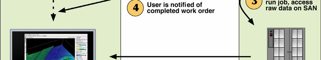

26 The Origami Experiment

27 Viewing multiple data blocks (cubes or granules) as part of a single visualization request across a larger geographic area.

28 McIDAS-V Transition Plan Built upon the existing capabilities of VisAD/IDV Incorporate the functionality of the Hyperspectral Data for Research Analysis (HYDRA) toolkit Allows McIDAS-X heritage code to be usable in the new environment without a need to rewrite Bridge software allows McIDAS-X commands to be submitted from the McIDAS-V display Provides a new environment for developing algorithms and new visualizations that take advantage of multi and hyper-spectral data from emerging observing systems
29 McIDAS-V Future Work Complete HYDRA integration Complete development of the X to V Bridge to provide an evolutionary path for MUG into McIDAS-V (October 2007) Alpha 1.0 release at 10/2007 MUG meeting Support the development of applications for the NPP/NPOESS and GOES R science teams (ongoing) Data management and accessibility Broad array of formats and services Advanced analysis and visualization tools
30 Interactive Processing of Multi- and Hyper-spectral Environmental Satellite Data: The Next Generation of McIDAS EUMETSAT-AMS Conf. Amsterdam, NL 27 September 2007 Tom Achtor, Tom Rink, Tom Whittaker Space Science & Engineering Center (SSEC) at the University of Wisconsin - Madison
McIDAS-V: An open source data analysis and visualization tool for multiand hyperspectral satellite data ITSC-XVI, Angra do Reis, Brazil, 7 May 2008
 McIDAS-V: An open source data analysis and visualization tool for multiand hyperspectral satellite data ITSC-XVI, Angra do Reis, Brazil, 7 May 2008 Tom Achtor, Tom Rink, Tom Whittaker, Dave Parker, Gail
McIDAS Transition Summary Tom Achtor McIDAS Users Group Meeting Madison, WI - 17 October 2007
 McIDAS Transition Summary Tom Achtor McIDAS Users Group Meeting Madison, WI - 17 October 2007 Space Science & Engineering Center (SSEC) at the University of Wisconsin - Madison Interactive Processing of
McIDAS-V - A powerful data analysis and visualization tool for multi and hyperspectral environmental satellite data *
 McIDAS-V - A powerful data analysis and visualization tool for multi and hyperspectral environmental satellite data * Thomas Achtor, Thomas Rink, Thomas Whittaker, David Parker and David Santek Space Science
McIDAS-V Tutorial Installation and Introduction updated September 2015 (software version 1.5)
") McIDAS-V Tutorial Installation and Introduction updated September 2015 (software version 1.5) McIDAS-V is a free, open source, visualization and data analysis software package that is the next generation
McIDAS-V Tutorial Installation and Introduction updated September 2015 (software version 1.5) McIDAS-V is a free, open source, visualization and data analysis software package that is the next generation
The Integrated Data Viewer A Tool for Scientific Analysis and Visualization
 The Integrated Data Viewer A Tool for Scientific Analysis and Visualization Don Murray Unidata Program Center Overview What is the Integrated Data Viewer (IDV)? IDV features Web enabled features Client/Server
The Integrated Data Viewer A web-enabled enabled tool for geoscientific analysis and visualization
 The Integrated Data Viewer A web-enabled enabled tool for geoscientific analysis and visualization Don Murray Unidata Program Center University Corporation for Atmospheric Research Overview Unidata Overview
McIDAS Users Group MUG Update
 McIDAS Users Group MUG Update Becky Schaffer Program Manager McIDAS User Services MUG Update MUG Personnel What s New in 2016 Who uses McIDAS-X and McIDAS-V? McIDAS Support Requests How long will McIDAS-X
McIDAS-V Tutorial Using Simulated ABI Data updated July 2016 (software version 1.6)
") McIDAS-V Tutorial Using Simulated ABI Data updated July 2016 (software version 1.6) McIDAS-V is a free, open source, visualization and data analysis software package that is the next generation in SSEC's
McIDAS-V Tutorial Using Simulated ABI Data updated July 2016 (software version 1.6) McIDAS-V is a free, open source, visualization and data analysis software package that is the next generation in SSEC's
McIDAS Users Group MUG Update
 McIDAS Users Group MUG Update Becky Schaffer Program Manager McIDAS User Services MUG Update What s New in 2015 MUG Personnel McIDAS-V McIDAS Support What s New in 2015 Happy Anniversary! 2013 was the
Toward the Development of a Comprehensive Data & Information Management System for THORPEX
 Toward the Development of a Comprehensive Data & Information Management System for THORPEX Mohan Ramamurthy, Unidata Steve Williams, JOSS Jose Meitin, JOSS Karyn Sawyer, JOSS UCAR Office of Programs Boulder,
McIDAS-V Tutorial. Displaying Suomi NPP Data. updated January 2016 (software version 1.5)
") McIDAS-V Tutorial Displaying Suomi NPP Data updated January 2016 (software version 1.5) McIDAS-V is a free, open source, visualization and data analysis software package that is the next generation in
McIDAS-V Tutorial Displaying Suomi NPP Data updated January 2016 (software version 1.5) McIDAS-V is a free, open source, visualization and data analysis software package that is the next generation in
McIDAS-V Tutorial Displaying Polar Satellite Imagery updated July 2016 (software version 1.6)
") McIDAS-V Tutorial Displaying Polar Satellite Imagery updated July 2016 (software version 1.6) McIDAS-V is a free, open source, visualization and data analysis software package that is the next generation
McIDAS-V Tutorial Displaying Polar Satellite Imagery updated July 2016 (software version 1.6) McIDAS-V is a free, open source, visualization and data analysis software package that is the next generation
McIDAS-V Tutorial Importing Data from Text Files updated July 2016 (software version 1.6)
") McIDAS-V Tutorial Importing Data from Text Files updated July 2016 (software version 1.6) McIDAS-V is a free, open source, visualization and data analysis software package that is the next generation in
McIDAS-V Tutorial Importing Data from Text Files updated July 2016 (software version 1.6) McIDAS-V is a free, open source, visualization and data analysis software package that is the next generation in
McIDAS-V Tutorial Using and Creating Formulas updated September 2013 (software version 1.4)
") McIDAS-V Tutorial Using and Creating Formulas updated September 2013 (software version 1.4) McIDAS-V is a free, open source, visualization and data analysis software package that is the next generation
McIDAS-V Tutorial Using and Creating Formulas updated September 2013 (software version 1.4) McIDAS-V is a free, open source, visualization and data analysis software package that is the next generation
RAMADDA and THREDDS. Projects. Tom Yoksas, John Caron, Ethan Davis 1 Jeff McWhirter 2, Don Murray 3 Matthew Lazzara 4. Unidata Program Center/UCAR 2
 Use in Support of Two Disparate RAMADDA and THREDDS Projects Tom Yoksas, John Caron, Ethan Davis 1 Jeff McWhirter 2, Don Murray 3 Matthew Lazzara 4 1 Program Center/UCAR 2 UNAVCO 3 NOAA/ESRL/PSD and CIRES
The Many Facets of THREDDS Thematic Real-time Environmental Distributed Data Services
 The Many Facets of THREDDS Thematic Real-time Environmental Distributed Data Services For March 2007 Unidata Policy Committee Meeting Ben Domenico 1 Motivation From the Unidata 2003 proposal: utilizing
Unidata and data-proximate analysis and visualization in the cloud
 Unidata and data-proximate analysis and visualization in the cloud Mohan Ramamurthy and Many Unidata Staff 1 June 2017 Modeling in the Cloud Workshop Unidata: A program of the community, by the community,
McIDAS-V Tutorial. Displaying Suomi NPP Data. updated June 2015 (software version 1.5)
") McIDAS-V Tutorial Displaying Suomi NPP Data updated June 2015 (software version 1.5) McIDAS-V is a free, open source, visualization and data analysis software package that is the next generation in SSEC's
McIDAS-V Tutorial Displaying Suomi NPP Data updated June 2015 (software version 1.5) McIDAS-V is a free, open source, visualization and data analysis software package that is the next generation in SSEC's
McIDAS-V Tutorial Displaying Level II Radar Imagery updated July 2016 (software version 1.6)
") McIDAS-V Tutorial Displaying Level II Radar Imagery updated July 2016 (software version 1.6) McIDAS-V is a free, open source, visualization and data analysis software package that is the next generation
McIDAS-V Tutorial Displaying Level II Radar Imagery updated July 2016 (software version 1.6) McIDAS-V is a free, open source, visualization and data analysis software package that is the next generation
ORIGAMI AND GIPS: RUNNING A HYPERSPECTRAL SOUNDER PROCESSING SYSTEM ON A LIGHTWEIGHT ON-DEMAND DISTRIBUTED COMPUTING FRAMEWORK
 ORIGAMI AND GIPS: RUNNING A HYPERSPECTRAL SOUNDER PROCESSING SYSTEM ON A LIGHTWEIGHT ON-DEMAND DISTRIBUTED COMPUTING FRAMEWORK Maciej Smuga-Otto, Raymond Garcia, Graeme Martin, Bruce Flynn, Robert Knuteson
Steve Ansari *, Stephen Del Greco, Neal Lott NOAA National Climatic Data Center, Asheville, North Carolina 2. DATA
 5A.1 THE WEATHER AND CLIMATE TOOLKIT Steve Ansari *, Stephen Del Greco, Neal Lott NOAA National Climatic Data Center, Asheville, North Carolina ABSTRACT The Weather and Climate Toolkit (WCT) is free, platform
Python: Working with Multidimensional Scientific Data. Nawajish Noman Deng Ding
 Python: Working with Multidimensional Scientific Data Nawajish Noman Deng Ding Outline Scientific Multidimensional Data Ingest and Data Management Analysis and Visualization Extending Analytical Capabilities
NWP SAF CIMMS Liaison Meeting, May 2006
 NWP SAF Satellite Application Facility for Numerical Weather Prediction Document NWPSAF-MO-VS-021 Version 1.0 May 2006 NWP SAF CIMMS Liaison Meeting, 15-17 May 2006 Nigel Atkinson 1, Pascal Brunel 2 and
Kenneth A. Hawick P. D. Coddington H. A. James
 Student: Vidar Tulinius Email: vidarot@brandeis.edu Distributed frameworks and parallel algorithms for processing large-scale geographic data Kenneth A. Hawick P. D. Coddington H. A. James Overview Increasing
NetCDF and HDF5. NASA Earth Science Data Systems Working Group October 20, 2010 New Orleans. Ed Hartnett, Unidata/UCAR, 2010
 NetCDF and HDF5 NASA Earth Science Data Systems Working Group October 20, 2010 New Orleans Ed Hartnett, Unidata/UCAR, 2010 Unidata Mission: To provide the data services, tools, and cyberinfrastructure
The Comprehensive Large Array Stewardship System (CLASS) Living with a multi- petabyte resource. CLASS A Component of NOAA Data Management
 Living with a multi- petabyte resource. CLASS A Component of NOAA Data Management") The Comprehensive Large Array Stewardship System () Living with a multi- petabyte resource 1 Outline What is? The role of in NOAA? The Future of Hardware API s Relation to Data Centers 2 Why do I care?
The Comprehensive Large Array Stewardship System () Living with a multi- petabyte resource 1 Outline What is? The role of in NOAA? The Future of Hardware API s Relation to Data Centers 2 Why do I care?
McIDAS-V Tutorial Displaying Gridded Data updated January 2016 (software version 1.5)
") McIDAS-V Tutorial Displaying Gridded Data updated January 2016 (software version 1.5) McIDAS-V is a free, open source, visualization and data analysis software package that is the next generation in SSEC's
McIDAS-V Tutorial Displaying Gridded Data updated January 2016 (software version 1.5) McIDAS-V is a free, open source, visualization and data analysis software package that is the next generation in SSEC's
McIDAS-X Software Development and Demonstration
 McIDAS-X Software Development and Demonstration Dave Santek and Jay Heinzelman 16 October 2007 Overview McIDAS-X 2006, 2007 McIDAS-XRD 2006, 2007 Software Development in 2007 Software Plans for 2008 McIDAS-X
Managing Scientific Data Efficiently in a DBMS
 Introduced by: Presented by: Managing Scientific Data Efficiently in a DBMS Christine D Angela (IBM Corporation) Ian Barrodale (Barrodale Computing Services - BCS) and Robert Uleman (IBM Corporation) Date:02/18/2009
NOAA s Archive, Access, and Assessment of Satellite Data for Climate Applications
 NOAA s Archive, Access, and Assessment of Satellite Data for Climate Applications John J. Bates, Chief Remote Sensing Applications Division NOAA/NESDIS National Climatic Data Center, Asheville, North Carolina,
Products and Software Working Group
 Products and Software Working Group Action items from ITSC-18 Nathalie Selbach, Liam Gumley and Nigel Atkinson Web site Action 1.1: Decide on a solution for working group user driven content and set up
Data Centre NetCDF Implementation Pilot
 Data Centre NetCDF Implementation Pilot Peter Miu EUMETSAT User Conference Oslo, Sep. 2011 Splinter Session, Facilitating Data Access and Utilisation Slide: 1 EUM/OPS/VWG/11/2600 V.1 What is this Pilot
Uniform Resource Locator Wide Area Network World Climate Research Programme Coupled Model Intercomparison
 Glossary API Application Programming Interface AR5 IPCC Assessment Report 4 ASCII American Standard Code for Information Interchange BUFR Binary Universal Form for the Representation of meteorological
A ONE-STOP SERVICE HUB INTEGRATING ESSENTIAL WEATHER AND GEOPHYSICAL INFORMATION ON A GIS PLATFORM. Hong Kong Observatory
 A ONE-STOP SERVICE HUB INTEGRATING ESSENTIAL WEATHER AND GEOPHYSICAL INFORMATION ON A GIS PLATFORM Hong Kong Observatory Mission HONG KONG OBSERVATORY To provide people-oriented quality services in meteorology
McIDAS-V Tutorial Displaying Gridded Data updated June 2015 (software version 1.5)
") McIDAS-V Tutorial Displaying Gridded Data updated June 2015 (software version 1.5) McIDAS-V is a free, open source, visualization and data analysis software package that is the next generation in SSEC's
McIDAS-V Tutorial Displaying Gridded Data updated June 2015 (software version 1.5) McIDAS-V is a free, open source, visualization and data analysis software package that is the next generation in SSEC's
Physical Modeling for Processing Geosynchronous Imaging Fourier Transform Spectrometer (GIFTS) Indian Ocean METOC Imager (IOMI) Hyperspectral Data
 Indian Ocean METOC Imager (IOMI) Hyperspectral Data") University of Wisconsin - Madison (UW) University of Hawaii (UH) Texas A& M (TAMU) University of Colorado at Boulder (CU) University of Alabama in Huntsville (UAH) MURI Physical Modeling for Processing
University of Wisconsin - Madison (UW) University of Hawaii (UH) Texas A& M (TAMU) University of Colorado at Boulder (CU) University of Alabama in Huntsville (UAH) MURI Physical Modeling for Processing
Distributed Online Data Access and Analysis
 Distributed Online Data Access and Analysis Ruixin Yang George Mason University Slides from SIESIP Partners and from NOMADS PI, Glenn K. Rutledge of US NCDC on NOMADS SIESIP: Seasonal-to-Interannual Earth
AAPP status report and preparations for processing METOP data
 AAPP status report and preparations for processing METOP data Nigel C Atkinson *, Pascal Brunel, Philippe Marguinaud and Tiphaine Labrot * Met Office, Exeter, UK Météo-France, Centre de Météorologie Spatiale,
Working with Scientific Data in ArcGIS Platform
 Working with Scientific Data in ArcGIS Platform Sudhir Raj Shrestha sshrestha@esri.com Hong Xu hxu@esri.com Esri User Conference, San Diego, CA. July 11, 2017 What we will cover today Scientific Multidimensional
cdo Data Processing (and Production) Luis Kornblueh, Uwe Schulzweida, Deike Kleberg, Thomas Jahns, Irina Fast
 Luis Kornblueh, Uwe Schulzweida, Deike Kleberg, Thomas Jahns, Irina Fast") cdo Data Processing (and Production) Luis Kornblueh, Uwe Schulzweida, Deike Kleberg, Thomas Jahns, Irina Fast Max-Planck-Institut für Meteorologie, DKRZ September 24, 2014 MAX-PLANCK-GESELLSCHAFT Data
cdo Data Processing (and Production) Luis Kornblueh, Uwe Schulzweida, Deike Kleberg, Thomas Jahns, Irina Fast Max-Planck-Institut für Meteorologie, DKRZ September 24, 2014 MAX-PLANCK-GESELLSCHAFT Data
Clare Richards, Benjamin Evans, Kate Snow, Chris Allen, Jingbo Wang, Kelsey A Druken, Sean Pringle, Jon Smillie and Matt Nethery. nci.org.
 The important role of HPC and data-intensive infrastructure facilities in supporting a diversity of Virtual Research Environments (VREs): working with Climate Clare Richards, Benjamin Evans, Kate Snow,
Cumulus Services Working Group. Dan Pilone SE TIM / August 2017
 Cumulus Services Working Group Dan Pilone dan@element84.com SE TIM / August 2017 2 Reminder: Why are we doing this? 3 Background: Motivation for Cloud Growth of Mission Data & Processing: Projected rapid
The CEDA Archive: Data, Services and Infrastructure
 The CEDA Archive: Data, Services and Infrastructure Kevin Marsh Centre for Environmental Data Archival (CEDA) www.ceda.ac.uk with thanks to V. Bennett, P. Kershaw, S. Donegan and the rest of the CEDA Team
Rapid Prototyping Capabilities for Conducting Research of Sun-Earth System
 Rapid Prototyping Capabilities for Conducting Research of Sun-Earth System T. Haupt, A. Kalyanasundaram, I. Zhuk High Performance Computing Collaboratory, Mississippi State University Abstract: This paper
Data Stewardship NOAA s Programs for Archive, Access, and Producing Climate Data Records
 Data Stewardship NOAA s Programs for Archive, Access, and Producing Climate Data Records John Bates, NOAA s National Climatic Data Center Mitch Goldberg, NOAA s Office of Research and Applications 1 Background
SPACE WEATHER PRODUCT GENERATION TRANSITION FROM SWPC to NESDIS. Arthur T McClinton Jr* Noblis, Inc., Falls Church, Virginia. 1.
 Session 7.8 SPACE WEATHER PRODUCT GENERATION TRANSITION FROM SWPC to NESDIS Arthur T McClinton Jr* Noblis, Inc., Falls Church, Virginia K. Mckenzie 1, S. Hill 2, C. Ortiz 2, A. Booth 3, and P. Yu 4 1 NOAA/NESDIS/OSD,
GEONETCast Future Plans at CIMH
 GEONETCast Future Plans at CIMH Operations, Training, Climate Monitoring and Disaster Preparedness WORLD METEOROLOGICAL ORGANIZATION COORDINATION GROUP ON SATELLITE DATA REQUIREMENTS FOR REGION III AND
HDF Update. Elena Pourmal The HDF Group. October 16, 2008 IDL User Group Meeting 1
 HDF Update Elena Pourmal The HDF Group October 16, 2008 IDL User Group Meeting 1 The HDF Group The HDF Group is a not-for-profit company with its mission focused on the support and growth of the HDF technologies
Database Web Portal Version 1
 Database Web Portal Version 1 Deliverable D6.5 Issue 0.2 Due date of deliverable: 01 Dec 2014 Actual submission date: 05 Dec 2014 SEN3APP Processing Lines And Operational Services Combining Sentinel And
CHAPTER 15 INVESTIGATING LAND, OCEAN, AND ATMOSPHERE WITH MULTISPECTRAL MEASUREMENTS
 CHAPTER 15 INVESTIGATING LAND, OCEAN, AND ATMOSPHERE WITH MULTISPECTRAL MEASUREMENTS 15.1 Introducing Hydra A multi-spectral data analysis toolkit has been developed using freeware; it is called Hydra.
Table of Contents. IDV User Guide. Unidata's Integrated Data Viewer...1/435 How can I get the IDV?...2/ Overview...3/435
 Table of Contents Unidata's Integrated Data Viewer...1/435 How can I get the IDV?...2/435 1 Overview...3/435 1.0 Release Notes...4/435 1.1. Use of netcdf 4.0 library...4/435 1.2. Use of Java 1.6...4/435
Hyperspectral Infrared Measurements Simulation and Collection for GOES-R Sounder Lossless and Lossy Data Compression Study and Beyond
 Hyperspectral Infrared Measurements Simulation and Collection for GOES-R Sounder Lossless and Lossy Data Compression Study and Beyond HUNG-LUNG HUANG, BORMIN HUANG, KEVIN BAGGETT, ALOK AHUJA Cooperative
GSICS Data and Products Server User Guide
 GSICS Data and Products Server User Guide Doc.No. : EUM/OPS/MAN/09/1146 Issue : v1 Date : 29 September 2009 EUMETSAT EUMETSAT Allee 1, D-64295 Darmstadt, Germany Tel: +49 6151 807-7 Fax: +49 6151 807 555
Using the Network Common Data Form for storage of atmospheric data
 Using the Network Common Data Form for storage of atmospheric data Maarten Plieger Royal Netherlands Meteorological Institute The NetCDF4 data format (Network Common Data Form) is used within the ADAGUC
McIDAS-X GOES-R Tutorial November 2016 (software version )
") McIDAS-X GOES-R Tutorial November 2016 (software version 2016.2) In existence since 1973, McIDAS (Man computer Interactive Data Access System) is a suite of sophisticated software packages that perform
McIDAS-X GOES-R Tutorial November 2016 (software version 2016.2) In existence since 1973, McIDAS (Man computer Interactive Data Access System) is a suite of sophisticated software packages that perform
BIG DATA CHALLENGES A NOAA PERSPECTIVE
 BIG DATA CHALLENGES A NOAA PERSPECTIVE Dr. Edward J. Kearns NASA Examiner, Science and Space Branch, OMB/EOP and Chief (acting), Remote Sensing and Applications Division National Climatic Data Center National
New Datasets, Functionality and Future Development. Ashwanth Srinivasan, (FSU) Steve Hankin (NOAA/PMEL) Major contributors: Jon Callahan (Mazama(
 Steve Hankin (NOAA/PMEL) Major contributors: Jon Callahan (Mazama(") HYCOM Data Service New Datasets, Functionality and Future Development Ashwanth Srinivasan, (FSU) Steve Hankin (NOAA/PMEL) Major contributors: Jon Callahan (Mazama( Consulting) Roland Schweitzer (Weathertop
HYCOM Data Service New Datasets, Functionality and Future Development Ashwanth Srinivasan, (FSU) Steve Hankin (NOAA/PMEL) Major contributors: Jon Callahan (Mazama( Consulting) Roland Schweitzer (Weathertop
Introduction to NetCDF
 Introduction to NetCDF NetCDF is a set of software libraries and machine-independent data formats that support the creation, access, and sharing of array-oriented scientific data. First released in 1989.
National Research Council Space Studies Board
 National Research Council Space Studies Board Mary E. Kicza Assistant Administrator for Satellite and Information Services National Oceanic and Atmospheric Administration March 9, 2010 National Oceanic
Table of Contents. IDV User Guide. Unidata's Integrated Data Viewer...1/483 How can I get the IDV?...2/ Overview...3/483
 Table of Contents Unidata's Integrated Data Viewer...1/483 How can I get the IDV?...2/483 1 Overview...3/483 1.0 Release Notes...4/483 1.1. IDV memory allocation...4/483 1.2. Mac OS X bundle...4/483 1.1
Table of Contents. IDV User Guide. Unidata's Integrated Data Viewer...1/408 How can I get the IDV?...2/ Overview...3/408
 Table of Contents Unidata's Integrated Data Viewer...1/408 How can I get the IDV?...2/408 1 Overview...3/408 1.0 Release Notes...4/408 Display Settings...4/408 Set vertical range in cross sections...4/408
Making data access easier with OPeNDAP. James Gallapher (OPeNDAP TM ) Duan Beckett (BoM) Kate Snow (NCI) Robert Davy (CSIRO) Adrian Burton (ARDC)
 Duan Beckett (BoM) Kate Snow (NCI) Robert Davy (CSIRO) Adrian Burton (ARDC)") Making data access easier with OPeNDAP James Gallapher (OPeNDAP TM ) Duan Beckett (BoM) Kate Snow (NCI) Robert Davy (CSIRO) Adrian Burton (ARDC) Outline Introduction and trajectory (James Gallapher) OPeNDAP
Making data access easier with OPeNDAP James Gallapher (OPeNDAP TM ) Duan Beckett (BoM) Kate Snow (NCI) Robert Davy (CSIRO) Adrian Burton (ARDC) Outline Introduction and trajectory (James Gallapher) OPeNDAP
ENVI. Get the Information You Need from Imagery.
 Visual Information Solutions ENVI. Get the Information You Need from Imagery. ENVI is the premier software solution to quickly, easily, and accurately extract information from geospatial imagery. Easy
2016 MUG Meeting McIDAS-V Demonstration Outline
 2016 MUG Meeting McIDAS-V Demonstration Outline Presented 17 November 2016 by Bob Carp and Jay Heinzelman, SSEC Note: The data files referenced in this document can be found at: ftp://ftp.ssec.wisc.edu/pub/mug/mug_meeting/2016/presentations/2016_mcidas-v_demo.zip
RealEarth. Real-time Visualization of Global Satellite Data and Derived Products
 RealEarth Real-time Visualization of Global Satellite Data and Derived Products Sam Batzli, Dave Parker, Russ Dengel, Nick Bearson, Dave Santek, Tommy Jasmin Space Science & Engineering Center University
Using ESML in a Semantic Web Approach for Improved Earth Science Data Usability
 Using in a Semantic Web Approach for Improved Earth Science Data Usability Rahul Ramachandran, Helen Conover, Sunil Movva and Sara Graves Information Technology and Systems Center University of Alabama
Comparison of Full-resolution S-NPP CrIS Radiance with Radiative Transfer Model
 Comparison of Full-resolution S-NPP CrIS Radiance with Radiative Transfer Model Xu Liu NASA Langley Research Center W. Wu, S. Kizer, H. Li, D. K. Zhou, and A. M. Larar Acknowledgements Yong Han NOAA STAR
NetCDF-4: : Software Implementing an Enhanced Data Model for the Geosciences
 NetCDF-4: : Software Implementing an Enhanced Data Model for the Geosciences Russ Rew, Ed Hartnett, and John Caron UCAR Unidata Program, Boulder 2006-01-31 Acknowledgments This work was supported by the
Understanding users workflows
 Understanding users workflows GloFAS current and future data services Fredrik Wetterhall 1 University of Leeds 6 September 2017 Objective of the talk and exercise 1. Demonstrate how GloFAS data is disseminated
Tech Talk On security, networking, and performance. Dave Parker UW SSEC
 Tech Talk On security, networking, and performance Dave Parker UW SSEC ADDE Security via SSH tunneling SSH fully encrypts all network traffic between the client and the server Secure shell for remote access
Machine learning approach to retrieving physical variables from remotely sensed data
 Machine learning approach to retrieving physical variables from remotely sensed data Fazlul Shahriar November 11, 2016 Introduction There is a growing wealth of remote sensing data from hundreds of space-based
P2.1 Accessing HDF5 data via OPeNDAP. MuQun Yang* 1, Hyo-Kyung Lee 1, James Gallagher 2. I. Introduction
 P2.1 Accessing HDF5 data via OPeNDAP MuQun Yang* 1, Hyo-Kyung Lee 1, James Gallagher 2 1 The HDF Group, 2 OPeNDAP, Inc. I. Introduction HDF[1] is a set of data formats and software libraries for storing
First experiences of using WC(P)S at ECMWF
S at ECMWF") Earth Server-2 First experiences of using WC(P)S at ECMWF Julia Wagemann and Stephan Siemen European Centre for Medium-Range Weather Forecasts Workshop on Meteorological Operational Systems #OpenDataWeek
Earth Server-2 First experiences of using WC(P)S at ECMWF Julia Wagemann and Stephan Siemen European Centre for Medium-Range Weather Forecasts Workshop on Meteorological Operational Systems #OpenDataWeek
McIDAS - XCD McIDAS Users Group Meeting
 McIDAS - XCD 2015 McIDAS Users Group Meeting Rewrite Team Kevin Baggett, Dan Forrest, Kevin Hallock, Jay Heinzelman, Dave Parker, Roseann Spangler, Becky Schaffer, Jerrold Robaidek, Clayton Suplinski McIDAS
Satellite Infrared Radiance Validation Studies using a Multi-Sensor/Model Data Fusion Approach
 Satellite Infrared Radiance Validation Studies using a Multi-Sensor/Model Data Fusion Approach Aqua A. Larar a, W. Smith b, D. Zhou a, X. Liu a, and S. Mango c a NASA Langley Research Center, Hampton,
Implementing a Data Quality Strategy to simplify access to data
 IN43D-07 AGU Fall Meeting 2016 Implementing a Quality Strategy to simplify access to data Kelsey Druken, Claire Trenham, Ben Evans, Clare Richards, Jingbo Wang, & Lesley Wyborn National Computational Infrastructure,
UV Remote Sensing of Volcanic Ash
 UV Remote Sensing of Volcanic Ash Kai Yang University of Maryland College Park WMO Inter-comparison of Satellite-based Volcanic Ash Retrieval Algorithms Workshop June 26 July 2, 2015, Madison, Wisconsin
DIAS_Satellite_MODIS_SurfaceReflectance dataset
 DIAS_Satellite_MODIS_SurfaceReflectance dataset 1. IDENTIFICATION INFORMATION DOI Metadata Identifier DIAS_Satellite_MODIS_SurfaceReflectance dataset doi:10.20783/dias.273 [http://doi.org/10.20783/dias.273]
NATIONAL OCEANIC AND ATMOSPHERIC ADMINISTRATION S SCIENTIFIC DATA STEWARDSHIP PROGRAM
 J2.3A NATIONAL OCEANIC AND ATMOSPHERIC ADMINISTRATION S SCIENTIFIC DATA STEWARDSHIP PROGRAM John J. Bates * NOAA National Climatic Center, Asheville, North Carolina Richard G. Reynolds Office of Systems
Scientific Data Plat f or m
 Usi n g Ar cgis as a Scientific Data Plat f or m Feroz Kadar Sudhir Raj Shrestha Top i cs Introduction Ingesting and managing Visualizing and analyzing Disseminating and consuming The road ahead Scientific
Open Software Standards for Next- Generation Community Satellite Software Packages June 2017
 Atmospheric and Environmental Research www.aer.com Lexington, MA 2017 IMAP/ CSPP Users Group Meeting Open Software Standards for Next- Generation Community Satellite Software Packages June 2017 David Hogan
Estimating land surface albedo from polar orbiting and geostationary satellites
 Estimating land surface albedo from polar orbiting and geostationary satellites Dongdong Wang Shunlin Liang Tao He Yuan Zhou Department of Geographical Sciences University of Maryland, College Park Nov
McIDAS-X Version 2008 Upgrade Procedure May 2008
 McIDAS-X Version 2008 Upgrade Procedure May 2008 Please take the time to read this entire document; it s important to understand the whole procedure before you begin. If you connect to ADDE remote servers
Use case: mapping sparse spatial data with TOPCAT
 Use case: mapping sparse spatial data with TOPCAT This use case describes a workflow related to large hyperspectral datasets. In this example you will use data from the VIRTIS/Rosetta experiment and study
THE EUCLID ARCHIVE SYSTEM: A DATA-CENTRIC APPROACH TO BIG DATA
 THE EUCLID ARCHIVE SYSTEM: A DATA-CENTRIC APPROACH TO BIG DATA Rees Williams on behalf of A.N.Belikov, D.Boxhoorn, B. Dröge, J.McFarland, A.Tsyganov, E.A. Valentijn University of Groningen, Groningen,
THE EUCLID ARCHIVE SYSTEM: A DATA-CENTRIC APPROACH TO BIG DATA
 THE EUCLID ARCHIVE SYSTEM: A DATA-CENTRIC APPROACH TO BIG DATA Sara Nieto on behalf of B.Altieri, G.Buenadicha, J. Salgado, P. de Teodoro European Space Astronomy Center, European Space Agency, Spain O.R.
Lidar Radar Open Software Environment LROSE and the Python ARM Radar Toolkit Py-ART
 Lidar Radar Open Software Environment LROSE and the Python ARM Radar Toolkit Py-ART Joe VanAndel and Mike Dixon Earth Observing Laboratory (EOL) National Center for Atmospheric Research (NCAR) Scott Collis
Investigation of Predictor-based Schemes for Lossless Compression of 3D Hyperspectral Sounder Data
 Investigation of Predictor-based Schemes for Lossless Compression of 3D Hyperspectral Sounder Data Bormin Huang 1*, Alok Ahuja 1, Hung-Lung Huang 1, Timothy J. Schmit 2, and Roger W. Heymann 3 1 Space
13.2 REVISTING 3D STEREO SATELLITE IMAGE DISPLAYS. 1. Introduction. 2. 3D Developments from 30 Years Ago-True Stereo. Frederick R.
 13.2 REVISTING 3D STEREO SATELLITE IMAGE DISPLAYS Frederick R. Mosher * Embry-Riddle Aeronautical University Daytona Beach, FL. 1. Introduction This past spring, a super salesperson convinced my Department
Cross-mission Analysis Through Space Physics Data Facility (SPDF) Services
 Services") Presented at the Fall 2012 AGU meeting Paper SM43A-2231 Cross-mission Analysis Through Space Physics Data Facility (SPDF) Services R.M. Candey, D. Bilitza, R. Chimiak, J.F. Cooper, L.N. Garcia, B. Harris,
Presented at the Fall 2012 AGU meeting Paper SM43A-2231 Cross-mission Analysis Through Space Physics Data Facility (SPDF) Services R.M. Candey, D. Bilitza, R. Chimiak, J.F. Cooper, L.N. Garcia, B. Harris,
Lab on MODIS Cloud spectral properties, Cloud Mask, NDVI and Fire Detection
 MODIS and AIRS Workshop 5 April 2006 Pretoria, South Africa 5/2/2006 10:54 AM LAB 2 Lab on MODIS Cloud spectral properties, Cloud Mask, NDVI and Fire Detection This Lab was prepared to provide practical
ARCHITECTURE OF MADIS DATA PROCESSING AND DISTRIBUTION AT FSL
 P2.39 ARCHITECTURE OF MADIS DATA PROCESSING AND DISTRIBUTION AT FSL 1. INTRODUCTION Chris H. MacDermaid*, Robert C. Lipschutz*, Patrick Hildreth*, Richard A. Ryan*, Amenda B. Stanley*, Michael F. Barth,
Data Discovery Tools and Services Part A
 Data Discovery Tools and Services Part A A Panel Presentation: Pat Liggett, Ron Weaver, Sean Hardman, Ben Holt (with help from Dave Gallaher, SIDC) October 15, 16 2008 Burbank Airport Marriott User Scenario:
HDF Product Designer: A tool for building HDF5 containers with granule metadata
 The HDF Group HDF Product Designer: A tool for building HDF5 containers with granule metadata Lindsay Powers Aleksandar Jelenak, Joe Lee, Ted Habermann The HDF Group Data Producer s Conundrum 2 HDF Features
The Logical Data Store
 Tenth ECMWF Workshop on Meteorological Operational Systems 14-18 November 2005, Reading The Logical Data Store Bruce Wright, John Ward & Malcolm Field Crown copyright 2005 Page 1 Contents The presentation
Desarrollo de una herramienta de visualización de datos oceanográficos: Modelos y Observaciones
 Desarrollo de una herramienta de visualización de datos oceanográficos: Modelos y Observaciones J. Fernandez, J. Lopez, I. Carlos, F. Jerez, F. Hermosilla, M. Espino SIMO, LIM-UPC, CIIRC FIELD_AC 7 th
FedGeoDay Interactive Visualization of Satellite (and Other) Data Online Using Cesium. October 13, 2016
 Data Online Using Cesium. October 13, 2016") FedGeoDay 2016 Interactive Visualization of Satellite (and Other) Data Online Using Cesium October 13, 2016 Matthew Lammers (matthew.r.lammers@nasa.gov) Web Analyst/Developer NASA Goddard Space Flight
FedGeoDay 2016 Interactive Visualization of Satellite (and Other) Data Online Using Cesium October 13, 2016 Matthew Lammers (matthew.r.lammers@nasa.gov) Web Analyst/Developer NASA Goddard Space Flight
Land surface temperature products validation for
 FRM4STS International Workshop, National Physical Laboratory, Teddington, UK Land surface temperature products validation for GOES-R and JPSS missions: status and challenge Yuhan Rao 1,2, Yunyue (Bob)
A hybrid object-based/pixel-based classification approach to detect geophysical phenomena
 A hybrid object-based/pixel-based classification approach to detect geophysical phenomena Xiang Li, Rahul Ramachandran*, Sara Graves, Sunil Movva Information Technology and Systems Center University of
Metview s new Python interface
 Metview s new Python interface Workshop on developing Python frameworks for earth system sciences. ECMWF, 2018 Iain Russell Development Section, ECMWF Thanks to Sándor Kertész Fernando Ii Stephan Siemen