McIDAS Transition Summary Tom Achtor McIDAS Users Group Meeting Madison, WI - 17 October 2007
|
|
|
- Johnathan Johnston
- 5 years ago
- Views:
Transcription


1 McIDAS Transition Summary Tom Achtor McIDAS Users Group Meeting Madison, WI - 17 October 2007 Space Science & Engineering Center (SSEC) at the University of Wisconsin - Madison
2 Interactive Processing of Multi- and Hyper-spectral Environmental Satellite Data: The Next Generation of McIDAS SPIE San Diego, CA - 28 August 2007 Tom Achtor, Tom Rink, Tom Whittaker Space Science & Engineering Center (SSEC) at the University of Wisconsin - Madison
3 McIDAS-V Conference Presentations AMS IIPS , 2006, 2007, 2008 AMS Sat Met AGU Fall Mtg 2005, 2007 SPIE
4 Outline The heritage of McIDAS-X What is McIDAS-V VisAD IDV Developing powerful McIDAS-V Components for future observing systems HYDRA X to V bridge Proxy/Origami/GEOCAT Supporting NPOESS and GOES R
5 Transition to McIDAS-V McIDAS nearly 35 years of development 1 st generation 1973 Harris/5 computer 2 nd generation 1978 Harris/6 computers, distributed system 3 rd generation 1984 IBM mainframe 43xx, OS/2 workstation 4 th generation 1992 McIDAS-X, Unix environment 5 th generation 2007 McIDAS-V
 Collection of user programs and libraries for visualizing and analyzing geophysical data (focus on environmental satellites) UNIX, PC & Mac capable A")
6 What is McIDAS-X? (Man computer Interactive Data Access System) Collection of user programs and libraries for visualizing and analyzing geophysical data (focus on environmental satellites) UNIX, PC & Mac capable A synergistic tool that integrates numerous data types into one system First developed in the early 1970s Still in use world-wide at research, operational, educational, and commercial sites
7 Key McIDAS-X Attributes Access to extensive geophysical database Core package plus user-written applications Diverse functionality through software (1 million + lines of code) Extensive visualization capabilities Satellite and NOAAPORT data ingest
8 McIDAS-X Functionality Digital Image Processing GIS Applications Weather and Climate Data Analysis and Applications Graphical Displays of Data & Information Gridded Data Processing and Analysis Tools Display & Process Control Utilities Interactive and Background Processing
9 McIDAS-X Users NOAA NESDIS, AWC, SPC, TPC, etc. NASA STS, LaRC, MSFC Unidata 130 universities, colleges and international collaborators International Australia, EUMETSAT, Greece, Kwajalein, Mexico, Spain, etc. Industry Honeywell, ImpactWeather, Meteorlogix, Weather Central, Weathernews, WTVT, etc.
10 Why the Change? Forthcoming GOES-R & NPOESS operational satellite data cannot be optimally utilized great increase in data rates new tools for working with these large data sets McIDAS software (written in Fortran 77 and C) has a 30+ year heritage resulting in limited extensibility potential New data analysis and visualization concepts cannot be incorporated (e.g. 4-D)
11 Project Requirements Create a powerful and versatile software system for environmental data processing, analysis and visualization Support existing and evolving needs of scientific research and algorithm/applications development for new programs Support data fusion and algorithm interoperability from existing and future sources Continue to fully support McIDAS Users Group (MUG) and McIDAS-X functionality as users transition to McIDAS-V Support operational users by providing frameworks in McIDAS-V, enabling a natural transition path for research results into operations Use system to educate students in remote sensing and physical sciences; involve students in its development, evolution and use
12 McIDAS-V Functionality McIDAS-V will be a collection of software tools, and networked services and data designed to take advantage of a scalable distributed computing environment to meet user needs McIDAS-X OpenADDE / OPeNDAP Open GIS Consortium Database archives Cluster computing
13 Transition to McIDAS-V McIDAS-V software built on SSEC s VisAD and Unidata s IDV libraries McIDAS-V 1.0alpha5 just the beginning Emphasize on user interface McIDAS-X bridge McIDAS-V open-source / freely available McIDAS-V user support available through McIDAS Users Group (MUG)
14 McIDAS-V 4 Goals for the MUG Meeting Easy installation and configuration of McIDAS-V and the McIDAS-X listener New McIDAS-V GUI McIDAS-V must be able to bridge with current McIDAS-X Integrate HYDRA (Hyperspectral Viewer for Development of Research Applications) into McIDAS-V
15 What is McIDAS-V McIDAS-X VisAD + IDV + HYDRA = McIDAS-V
16 The X to V Bridge Interacts with a McIDAS-X remote session Users provides command line input in a McIDAS-V Data Chooser that sends commands to a server running McIDAS-X Runs all McIDAS-X commands, including status, text, imagery and graphics McIDAS-X output displayed in McIDAS-V Allows bi-directional interactive communication between McIDAS-V and McIDAS-X


17 The X to V Bridge
18 What is McIDAS-V McIDAS-X VisAD + IDV + HYDRA = McIDAS-V

19

20 AIRS Cirrus vs Clear Sky Spectra


21
 is mapped to Red, Band8 minus Band9 (9.7,10.")

22 HYDRA RGB composite tool applied to MSG SEVIRI channels. In the above, Band 5 minus Band 6, (6.7micron,7.3micron) is mapped to Red, Band8 minus Band9 (9.7,10.8) is mappped to Green and Band5 is mapped to Red. The latter is inverted using the histogram stretch tool. This composite technique was developed by Eumetsat to emphasize cyclogenesis, jet-streaks and mid vs high-level clouds.
23 McIDAS-V Future Ported McIDAS-X Functionality McIDAS-V GUI HYDRA IDV VisAD NEW McIDAS-V Functionality McIDAS-X Bridge JAVA Servers Future Bridges MUG Packaged McIDAS-X mctext, mcimage, ADDE servers Other Servers OpenADDE, OPeNDAP Other Resources IDL, MATLAB, Origami, Database Access.. Data Commands Data Data
24 McIDAS-V is a collection of software tools, and networked services and data designed to take advantage of a scalable distributed computing environment to meet user needs. OPeNDAP/ ADDE GIS Cluster computing McIDAS-V GEOCAT McIDAS-X MATLAB/ IDL Database/ SAN
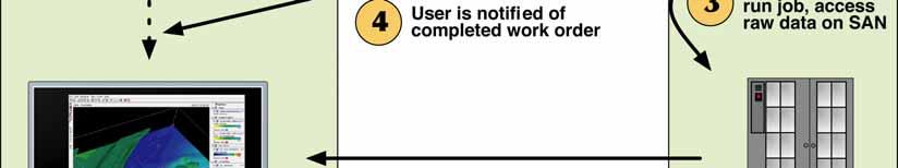
25 Origami Experiment Goals Visualization of meteorological fields from very large simulated model and retrieved data sets Submit request from web service or McIDAS-V Remotely query a large database to obtain the required data and load into an application or task Invoke the task on a cluster computer, reading from the database and writing results to a temporary file Inform the user where the output data resides and bring results into McIDAS-V


26 The Origami Experiment
27 GEOCAT Conceptual Model -Satellite Images -Ancillary Data Calibrated/navigated radiances and ancillary data are loaded into data structures that can be accessed by algorithms GEOCAT Navigation and Calibration Map ancillary data to pixel level Calculate clear sky radiances (if needed) L1 (radiances) L2 (pixel-level products) RTM (clear radiances) Execute higher order algorithms Execute lower order algorithms Output from high order algorithms is available to lower level algorithms
28 GEOCAT - McIDAS-V Link McIDAS-V can readily access services following emerging standards for distributed application systems. For algorithm testing on large proxy, simulation and real datasets, the GEOCAT test framework can be distributed on computing clusters. A toolset for submitting large GEOCAT calculations and directly displaying output in McIDAS-V will allow increased productivity for algorithm developers.
29 McIDAS-V Funding MUG is providing support for the Bridge and the GUI The IPO and GOES R Risk Reduction are supporting the integration of HYDRA The NASA PEATE project is providing some design support The GOES R Algorithm Working Group will provide development funds to support multi and hyperspectral data analysis
30 McIDAS-V Future Work Complete HYDRA integration Complete development of the X to V Bridge to provide an evolutionary path for MUG into McIDAS-V (October 2007) Beta 1.0 release forthcoming (early 2008) Support the development of applications for the NPP/NPOESS and GOES R science teams (ongoing) Data management and accessibility Broad array of formats and services Advanced analysis and visualization tools
31 McIDAS-V Next Areas for Development McIDAS-V, without the bridge, must access and output other types of data already available in McIDAS-X Display local and remote image datasets including archived satellite imagery Plot and contour local and remote McIDAS grid datasets Contour remote datasets and contour and plot local McIDAS point datasets Save the digital data file(s) generated in above
32 McIDAS-V Contributors McIDAS-X Kevin Baggett Jon Beavers Gail Dengel Rick Kohrs Dave Parker Becky Schaffer Jessica Staude VisAD/IDV/HYDRA Tom Whittaker Tom Rink Bruce Flynn Don Murray Jeff McWhirter Bill Hibbard Origami/GEOCAT Ray Garcia Maciek S-O Mike Pavolonis Bob Knuteson
33 McIDAS Transition Summary Tom Achtor McIDAS Users Group Meeting Madison, WI - 17 October 2007 Space Science & Engineering Center (SSEC) at the University of Wisconsin - Madison
Tom Achtor, Tom Rink, Tom Whittaker. Space Science & Engineering Center (SSEC) at the University of Wisconsin - Madison
 at the University of Wisconsin - Madison") Interactive Processing of Multi- and Hyper-spectral Environmental Satellite Data: The Next Generation of McIDAS EUMETSAT-AMS Conf. Amsterdam, NL 27 September 2007 Tom Achtor, Tom Rink, Tom Whittaker Space
Interactive Processing of Multi- and Hyper-spectral Environmental Satellite Data: The Next Generation of McIDAS EUMETSAT-AMS Conf. Amsterdam, NL 27 September 2007 Tom Achtor, Tom Rink, Tom Whittaker Space
McIDAS-V: An open source data analysis and visualization tool for multiand hyperspectral satellite data ITSC-XVI, Angra do Reis, Brazil, 7 May 2008
 McIDAS-V: An open source data analysis and visualization tool for multiand hyperspectral satellite data ITSC-XVI, Angra do Reis, Brazil, 7 May 2008 Tom Achtor, Tom Rink, Tom Whittaker, Dave Parker, Gail
McIDAS-V - A powerful data analysis and visualization tool for multi and hyperspectral environmental satellite data *
 McIDAS-V - A powerful data analysis and visualization tool for multi and hyperspectral environmental satellite data * Thomas Achtor, Thomas Rink, Thomas Whittaker, David Parker and David Santek Space Science
McIDAS Users Group MUG Update
 McIDAS Users Group MUG Update Becky Schaffer Program Manager McIDAS User Services MUG Update What s New in 2015 MUG Personnel McIDAS-V McIDAS Support What s New in 2015 Happy Anniversary! 2013 was the
McIDAS Users Group MUG Update
 McIDAS Users Group MUG Update Becky Schaffer Program Manager McIDAS User Services MUG Update MUG Personnel What s New in 2016 Who uses McIDAS-X and McIDAS-V? McIDAS Support Requests How long will McIDAS-X
ORIGAMI AND GIPS: RUNNING A HYPERSPECTRAL SOUNDER PROCESSING SYSTEM ON A LIGHTWEIGHT ON-DEMAND DISTRIBUTED COMPUTING FRAMEWORK
 ORIGAMI AND GIPS: RUNNING A HYPERSPECTRAL SOUNDER PROCESSING SYSTEM ON A LIGHTWEIGHT ON-DEMAND DISTRIBUTED COMPUTING FRAMEWORK Maciej Smuga-Otto, Raymond Garcia, Graeme Martin, Bruce Flynn, Robert Knuteson
McIDAS-V Tutorial Installation and Introduction updated September 2015 (software version 1.5)
") McIDAS-V Tutorial Installation and Introduction updated September 2015 (software version 1.5) McIDAS-V is a free, open source, visualization and data analysis software package that is the next generation
McIDAS-V Tutorial Installation and Introduction updated September 2015 (software version 1.5) McIDAS-V is a free, open source, visualization and data analysis software package that is the next generation
RAMADDA and THREDDS. Projects. Tom Yoksas, John Caron, Ethan Davis 1 Jeff McWhirter 2, Don Murray 3 Matthew Lazzara 4. Unidata Program Center/UCAR 2
 Use in Support of Two Disparate RAMADDA and THREDDS Projects Tom Yoksas, John Caron, Ethan Davis 1 Jeff McWhirter 2, Don Murray 3 Matthew Lazzara 4 1 Program Center/UCAR 2 UNAVCO 3 NOAA/ESRL/PSD and CIRES
The Integrated Data Viewer A Tool for Scientific Analysis and Visualization
 The Integrated Data Viewer A Tool for Scientific Analysis and Visualization Don Murray Unidata Program Center Overview What is the Integrated Data Viewer (IDV)? IDV features Web enabled features Client/Server
Toward the Development of a Comprehensive Data & Information Management System for THORPEX
 Toward the Development of a Comprehensive Data & Information Management System for THORPEX Mohan Ramamurthy, Unidata Steve Williams, JOSS Jose Meitin, JOSS Karyn Sawyer, JOSS UCAR Office of Programs Boulder,
McIDAS-V Tutorial Using Simulated ABI Data updated July 2016 (software version 1.6)
") McIDAS-V Tutorial Using Simulated ABI Data updated July 2016 (software version 1.6) McIDAS-V is a free, open source, visualization and data analysis software package that is the next generation in SSEC's
McIDAS-V Tutorial Using Simulated ABI Data updated July 2016 (software version 1.6) McIDAS-V is a free, open source, visualization and data analysis software package that is the next generation in SSEC's
The Integrated Data Viewer A web-enabled enabled tool for geoscientific analysis and visualization
 The Integrated Data Viewer A web-enabled enabled tool for geoscientific analysis and visualization Don Murray Unidata Program Center University Corporation for Atmospheric Research Overview Unidata Overview
McIDAS - XCD McIDAS Users Group Meeting
 McIDAS - XCD 2015 McIDAS Users Group Meeting Rewrite Team Kevin Baggett, Dan Forrest, Kevin Hallock, Jay Heinzelman, Dave Parker, Roseann Spangler, Becky Schaffer, Jerrold Robaidek, Clayton Suplinski McIDAS
McIDAS-V Tutorial Displaying Polar Satellite Imagery updated July 2016 (software version 1.6)
") McIDAS-V Tutorial Displaying Polar Satellite Imagery updated July 2016 (software version 1.6) McIDAS-V is a free, open source, visualization and data analysis software package that is the next generation
McIDAS-V Tutorial Displaying Polar Satellite Imagery updated July 2016 (software version 1.6) McIDAS-V is a free, open source, visualization and data analysis software package that is the next generation
Unidata and data-proximate analysis and visualization in the cloud
 Unidata and data-proximate analysis and visualization in the cloud Mohan Ramamurthy and Many Unidata Staff 1 June 2017 Modeling in the Cloud Workshop Unidata: A program of the community, by the community,
Open Software Standards for Next- Generation Community Satellite Software Packages June 2017
 Atmospheric and Environmental Research www.aer.com Lexington, MA 2017 IMAP/ CSPP Users Group Meeting Open Software Standards for Next- Generation Community Satellite Software Packages June 2017 David Hogan
NOAA Satellite and Information Service Dan St. Jean, NESDIS Office of Systems Architecture and Advance Planning
 NOAA/NESDIS Updates on Architecture Studies and Commercial Data Process Committee on Earth Science and Applications from Space December 2, 2015 NOAA Satellite and Information Service Dan St. Jean, NESDIS
McIDAS-V Tutorial. Displaying Suomi NPP Data. updated January 2016 (software version 1.5)
") McIDAS-V Tutorial Displaying Suomi NPP Data updated January 2016 (software version 1.5) McIDAS-V is a free, open source, visualization and data analysis software package that is the next generation in
McIDAS-V Tutorial Displaying Suomi NPP Data updated January 2016 (software version 1.5) McIDAS-V is a free, open source, visualization and data analysis software package that is the next generation in
McIDAS-V Tutorial. Displaying Suomi NPP Data. updated June 2015 (software version 1.5)
") McIDAS-V Tutorial Displaying Suomi NPP Data updated June 2015 (software version 1.5) McIDAS-V is a free, open source, visualization and data analysis software package that is the next generation in SSEC's
McIDAS-V Tutorial Displaying Suomi NPP Data updated June 2015 (software version 1.5) McIDAS-V is a free, open source, visualization and data analysis software package that is the next generation in SSEC's
The Many Facets of THREDDS Thematic Real-time Environmental Distributed Data Services
 The Many Facets of THREDDS Thematic Real-time Environmental Distributed Data Services For March 2007 Unidata Policy Committee Meeting Ben Domenico 1 Motivation From the Unidata 2003 proposal: utilizing
AAPP status report and preparations for processing METOP data
 AAPP status report and preparations for processing METOP data Nigel C Atkinson *, Pascal Brunel, Philippe Marguinaud and Tiphaine Labrot * Met Office, Exeter, UK Météo-France, Centre de Météorologie Spatiale,
Hyperspectral Infrared Measurements Simulation and Collection for GOES-R Sounder Lossless and Lossy Data Compression Study and Beyond
 Hyperspectral Infrared Measurements Simulation and Collection for GOES-R Sounder Lossless and Lossy Data Compression Study and Beyond HUNG-LUNG HUANG, BORMIN HUANG, KEVIN BAGGETT, ALOK AHUJA Cooperative
Kenneth A. Hawick P. D. Coddington H. A. James
 Student: Vidar Tulinius Email: vidarot@brandeis.edu Distributed frameworks and parallel algorithms for processing large-scale geographic data Kenneth A. Hawick P. D. Coddington H. A. James Overview Increasing
McIDAS-V Tutorial Importing Data from Text Files updated July 2016 (software version 1.6)
") McIDAS-V Tutorial Importing Data from Text Files updated July 2016 (software version 1.6) McIDAS-V is a free, open source, visualization and data analysis software package that is the next generation in
McIDAS-V Tutorial Importing Data from Text Files updated July 2016 (software version 1.6) McIDAS-V is a free, open source, visualization and data analysis software package that is the next generation in
McIDAS-V Tutorial Using and Creating Formulas updated September 2013 (software version 1.4)
") McIDAS-V Tutorial Using and Creating Formulas updated September 2013 (software version 1.4) McIDAS-V is a free, open source, visualization and data analysis software package that is the next generation
McIDAS-V Tutorial Using and Creating Formulas updated September 2013 (software version 1.4) McIDAS-V is a free, open source, visualization and data analysis software package that is the next generation
Tech Talk On security, networking, and performance. Dave Parker UW SSEC
 Tech Talk On security, networking, and performance Dave Parker UW SSEC ADDE Security via SSH tunneling SSH fully encrypts all network traffic between the client and the server Secure shell for remote access
McIDAS-V Tutorial Displaying Gridded Data updated June 2015 (software version 1.5)
") McIDAS-V Tutorial Displaying Gridded Data updated June 2015 (software version 1.5) McIDAS-V is a free, open source, visualization and data analysis software package that is the next generation in SSEC's
McIDAS-V Tutorial Displaying Gridded Data updated June 2015 (software version 1.5) McIDAS-V is a free, open source, visualization and data analysis software package that is the next generation in SSEC's
Lidar Radar Open Software Environment LROSE and the Python ARM Radar Toolkit Py-ART
 Lidar Radar Open Software Environment LROSE and the Python ARM Radar Toolkit Py-ART Joe VanAndel and Mike Dixon Earth Observing Laboratory (EOL) National Center for Atmospheric Research (NCAR) Scott Collis
McIDAS-V Tutorial Displaying Gridded Data updated January 2016 (software version 1.5)
") McIDAS-V Tutorial Displaying Gridded Data updated January 2016 (software version 1.5) McIDAS-V is a free, open source, visualization and data analysis software package that is the next generation in SSEC's
McIDAS-V Tutorial Displaying Gridded Data updated January 2016 (software version 1.5) McIDAS-V is a free, open source, visualization and data analysis software package that is the next generation in SSEC's
McIDAS-X Version 2008 Upgrade Procedure May 2008
 McIDAS-X Version 2008 Upgrade Procedure May 2008 Please take the time to read this entire document; it s important to understand the whole procedure before you begin. If you connect to ADDE remote servers
McIDAS-X Software Development and Demonstration
 McIDAS-X Software Development and Demonstration Dave Santek and Jay Heinzelman 16 October 2007 Overview McIDAS-X 2006, 2007 McIDAS-XRD 2006, 2007 Software Development in 2007 Software Plans for 2008 McIDAS-X
RealEarth. Real-time Visualization of Global Satellite Data and Derived Products
 RealEarth Real-time Visualization of Global Satellite Data and Derived Products Sam Batzli, Dave Parker, Russ Dengel, Nick Bearson, Dave Santek, Tommy Jasmin Space Science & Engineering Center University
NWP SAF CIMMS Liaison Meeting, May 2006
 NWP SAF Satellite Application Facility for Numerical Weather Prediction Document NWPSAF-MO-VS-021 Version 1.0 May 2006 NWP SAF CIMMS Liaison Meeting, 15-17 May 2006 Nigel Atkinson 1, Pascal Brunel 2 and
SPACE WEATHER PRODUCT GENERATION TRANSITION FROM SWPC to NESDIS. Arthur T McClinton Jr* Noblis, Inc., Falls Church, Virginia. 1.
 Session 7.8 SPACE WEATHER PRODUCT GENERATION TRANSITION FROM SWPC to NESDIS Arthur T McClinton Jr* Noblis, Inc., Falls Church, Virginia K. Mckenzie 1, S. Hill 2, C. Ortiz 2, A. Booth 3, and P. Yu 4 1 NOAA/NESDIS/OSD,
NetCDF-4: : Software Implementing an Enhanced Data Model for the Geosciences
 NetCDF-4: : Software Implementing an Enhanced Data Model for the Geosciences Russ Rew, Ed Hartnett, and John Caron UCAR Unidata Program, Boulder 2006-01-31 Acknowledgments This work was supported by the
McIDAS-X GOES-R Tutorial November 2016 (software version )
") McIDAS-X GOES-R Tutorial November 2016 (software version 2016.2) In existence since 1973, McIDAS (Man computer Interactive Data Access System) is a suite of sophisticated software packages that perform
McIDAS-X GOES-R Tutorial November 2016 (software version 2016.2) In existence since 1973, McIDAS (Man computer Interactive Data Access System) is a suite of sophisticated software packages that perform
EUMETSAT response on ET SAT Action 5.1
 EUMETSAT response on ET SAT Action 5.1 Contents 1 Background... 1 2 Requirements for hosting the RRR database and related DOORS capabilities... 2 3 Tentative data model for the GOS Dossier... 3 3.1 GOS
GEONETCast Future Plans at CIMH
 GEONETCast Future Plans at CIMH Operations, Training, Climate Monitoring and Disaster Preparedness WORLD METEOROLOGICAL ORGANIZATION COORDINATION GROUP ON SATELLITE DATA REQUIREMENTS FOR REGION III AND
Steve Ansari *, Stephen Del Greco, Neal Lott NOAA National Climatic Data Center, Asheville, North Carolina 2. DATA
 5A.1 THE WEATHER AND CLIMATE TOOLKIT Steve Ansari *, Stephen Del Greco, Neal Lott NOAA National Climatic Data Center, Asheville, North Carolina ABSTRACT The Weather and Climate Toolkit (WCT) is free, platform
The Logical Data Store
 Tenth ECMWF Workshop on Meteorological Operational Systems 14-18 November 2005, Reading The Logical Data Store Bruce Wright, John Ward & Malcolm Field Crown copyright 2005 Page 1 Contents The presentation
Universities Access IBM/Google Cloud Compute Cluster for NSF-Funded Research
 CollabrATEC ATEC 6351.002 Research and Design Home Archive Assignments Environment Ideas Interface Presentation Technology Narrative Search Universities Access IBM/Google Cloud Compute Cluster for NSF-Funded
New Datasets, Functionality and Future Development. Ashwanth Srinivasan, (FSU) Steve Hankin (NOAA/PMEL) Major contributors: Jon Callahan (Mazama(
 Steve Hankin (NOAA/PMEL) Major contributors: Jon Callahan (Mazama(") HYCOM Data Service New Datasets, Functionality and Future Development Ashwanth Srinivasan, (FSU) Steve Hankin (NOAA/PMEL) Major contributors: Jon Callahan (Mazama( Consulting) Roland Schweitzer (Weathertop
HYCOM Data Service New Datasets, Functionality and Future Development Ashwanth Srinivasan, (FSU) Steve Hankin (NOAA/PMEL) Major contributors: Jon Callahan (Mazama( Consulting) Roland Schweitzer (Weathertop
EarthCube and Cyberinfrastructure for the Earth Sciences: Lessons and Perspective from OpenTopography
 EarthCube and Cyberinfrastructure for the Earth Sciences: Lessons and Perspective from OpenTopography Christopher Crosby, San Diego Supercomputer Center J Ramon Arrowsmith, Arizona State University Chaitan
McIDAS-V Tutorial Displaying Level II Radar Imagery updated July 2016 (software version 1.6)
") McIDAS-V Tutorial Displaying Level II Radar Imagery updated July 2016 (software version 1.6) McIDAS-V is a free, open source, visualization and data analysis software package that is the next generation
McIDAS-V Tutorial Displaying Level II Radar Imagery updated July 2016 (software version 1.6) McIDAS-V is a free, open source, visualization and data analysis software package that is the next generation
Introduction to FREE National Resources for Scientific Computing. Dana Brunson. Jeff Pummill
 Introduction to FREE National Resources for Scientific Computing Dana Brunson Oklahoma State University High Performance Computing Center Jeff Pummill University of Arkansas High Peformance Computing Center
NOAA s Archive, Access, and Assessment of Satellite Data for Climate Applications
 NOAA s Archive, Access, and Assessment of Satellite Data for Climate Applications John J. Bates, Chief Remote Sensing Applications Division NOAA/NESDIS National Climatic Data Center, Asheville, North Carolina,
Scientific Workflow Tools. Daniel Crawl and Ilkay Altintas San Diego Supercomputer Center UC San Diego
 Scientific Workflow Tools Daniel Crawl and Ilkay Altintas San Diego Supercomputer Center UC San Diego 1 escience Today Increasing number of Cyberinfrastructure (CI) technologies Data Repositories: Network
GSICS Data and Products Server User Guide
 GSICS Data and Products Server User Guide Doc.No. : EUM/OPS/MAN/09/1146 Issue : v1 Date : 29 September 2009 EUMETSAT EUMETSAT Allee 1, D-64295 Darmstadt, Germany Tel: +49 6151 807-7 Fax: +49 6151 807 555
The CEDA Archive: Data, Services and Infrastructure
 The CEDA Archive: Data, Services and Infrastructure Kevin Marsh Centre for Environmental Data Archival (CEDA) www.ceda.ac.uk with thanks to V. Bennett, P. Kershaw, S. Donegan and the rest of the CEDA Team
Modeling of the ageing effects on Meteosat First Generation Visible Band
 on on Meteosat First Generation Visible Band Ilse Decoster, N. Clerbaux, J. Cornelis, P.-J. Baeck, E. Baudrez, S. Dewitte, A. Ipe, S. Nevens, K. J. Priestley, A. Velazquez Royal Meteorological Institute
MTG-FCI: ATBD for Outgoing Longwave Radiation Product
 MTG-FCI: ATBD for Outgoing Longwave Radiation Product Doc.No. Issue : : EUM/MTG/DOC/10/0527 v2 EUMETSAT Eumetsat-Allee 1, D-64295 Darmstadt, Germany Tel: +49 6151 807-7 Fax: +49 6151 807 555 Date : 14
And now for something completely different
 And now for something completely different (data management?) HYCOM Data Management & Services Ashwanth Srinivasan (RSMAS) Steve Hankin (PMEL) A community of of contributors, including Peter Peter Cornillon,
Data Stewardship NOAA s Programs for Archive, Access, and Producing Climate Data Records
 Data Stewardship NOAA s Programs for Archive, Access, and Producing Climate Data Records John Bates, NOAA s National Climatic Data Center Mitch Goldberg, NOAA s Office of Research and Applications 1 Background
Spectral Classification
 Spectral Classification Spectral Classification Supervised versus Unsupervised Classification n Unsupervised Classes are determined by the computer. Also referred to as clustering n Supervised Classes
Eclipse, Java, Scientific Software, Etc.
 Eclipse, Java, Scientific Software, Etc. Kenneth Evans, Jr. Presented at the European Synchrotron Radiation Facility ESRF May 3, 2007 Grenoble, France Outline Scientific Software and Examples Java Eclipse
Ocean, Atmosphere & Climate Model Assessment for Everyone
 Ocean, Atmosphere & Climate Model Assessment for Everyone Rich Signell USGS Woods Hole, MA Unidata 2014 DeSouza Award Presentation Boulder, CO : Sep 15, 2014 2 US Integrated Ocean Observing System (IOOS
Scientific Visualization Services at RZG
 Scientific Visualization Services at RZG Klaus Reuter, Markus Rampp klaus.reuter@rzg.mpg.de Garching Computing Centre (RZG) 7th GOTiT High Level Course, Garching, 2010 Outline 1 Introduction 2 Details
Copernicus Data and Information Access Services(DIAS)
") Data and Information Access Services(DIAS) DG GROW EU EU EU www.copernicus.eu COPERNICUS IN BRIEF is a flagship programme of the European Union: Monitors the Earth, its environment and ecosystems Prepares
Data and Information Access Services(DIAS) DG GROW EU EU EU www.copernicus.eu COPERNICUS IN BRIEF is a flagship programme of the European Union: Monitors the Earth, its environment and ecosystems Prepares
ANSWER ALL QUESTIONS ON THE SEPARATE ANSWER SHEET
 GIS Career Awareness Learning Module Version 1.0 August 18, 2008 Your Family Tree Page GIS Application Estimated Time: 1.5 Hours Learning Goal: This module will introduce the application of GIS by using
NetCDF and HDF5. NASA Earth Science Data Systems Working Group October 20, 2010 New Orleans. Ed Hartnett, Unidata/UCAR, 2010
 NetCDF and HDF5 NASA Earth Science Data Systems Working Group October 20, 2010 New Orleans Ed Hartnett, Unidata/UCAR, 2010 Unidata Mission: To provide the data services, tools, and cyberinfrastructure
Lecture 1: January 22
 CMPSCI 677 Distributed and Operating Systems Spring 2018 Lecture 1: January 22 Lecturer: Prashant Shenoy Scribe: Bin Wang 1.1 Introduction to the course The lecture started by outlining the administrative
Extension of the CREWtype Analysis to VIIRS. Andrew Heidinger, Andi Walther, Yue Li and Denis Botambekov NOAA/NESDIS and UW/CIMSS, Madison, WI, USA
 Extension of the CREWtype Analysis to VIIRS Andrew Heidinger, Andi Walther, Yue Li and Denis Botambekov NOAA/NESDIS and UW/CIMSS, Madison, WI, USA CREW-4 Grainau, Germany, March 2014 Motivation Important
Lecture 1: January 23
 CMPSCI 677 Distributed and Operating Systems Spring 2019 Lecture 1: January 23 Lecturer: Prashant Shenoy Scribe: Jonathan Westin (2019), Bin Wang (2018) 1.1 Introduction to the course The lecture started
Managing Scientific Data Efficiently in a DBMS
 Introduced by: Presented by: Managing Scientific Data Efficiently in a DBMS Christine D Angela (IBM Corporation) Ian Barrodale (Barrodale Computing Services - BCS) and Robert Uleman (IBM Corporation) Date:02/18/2009
OPeNDAP: Accessing HYCOM (and other data) remotely
 remotely") OPeNDAP: Accessing HYCOM (and other data) remotely Presented at The HYCOM NOPP GODAE Meeting By Peter Cornillon OPeNDAP Inc., Narragansett, RI 02882 7 December 2005 8/25/05 HYCOM NOPP GODAE 1 Acknowledgements
OPeNDAP: Accessing HYCOM (and other data) remotely Presented at The HYCOM NOPP GODAE Meeting By Peter Cornillon OPeNDAP Inc., Narragansett, RI 02882 7 December 2005 8/25/05 HYCOM NOPP GODAE 1 Acknowledgements
NATIONAL OCEANIC AND ATMOSPHERIC ADMINISTRATION S SCIENTIFIC DATA STEWARDSHIP PROGRAM
 J2.3A NATIONAL OCEANIC AND ATMOSPHERIC ADMINISTRATION S SCIENTIFIC DATA STEWARDSHIP PROGRAM John J. Bates * NOAA National Climatic Center, Asheville, North Carolina Richard G. Reynolds Office of Systems
Introduction to Data Management for Ocean Science Research
 Introduction to Data Management for Ocean Science Research Cyndy Chandler Biological and Chemical Oceanography Data Management Office 12 November 2009 Ocean Acidification Short Course Woods Hole, MA USA
Introduction to Grid Computing
 Milestone 2 Include the names of the papers You only have a page be selective about what you include Be specific; summarize the authors contributions, not just what the paper is about. You might be able
Products and Software Working Group
 Products and Software Working Group Action items from ITSC-18 Nathalie Selbach, Liam Gumley and Nigel Atkinson Web site Action 1.1: Decide on a solution for working group user driven content and set up
MTG-FCI: ATBD for Clear Sky Reflectance Map Product
 MTG-FCI: ATBD for Clear Sky Reflectance Map Product Doc.No. Issue : : v2 EUMETSAT Eumetsat-Allee 1, D-64295 Darmstadt, Germany Tel: +49 6151 807-7 Fax: +49 6151 807 555 Date : 14 January 2013 http://www.eumetsat.int
The National Fusion Collaboratory
 The National Fusion Collaboratory A DOE National Collaboratory Pilot Project Presented by David P. Schissel at ICC 2004 Workshop May 27, 2004 Madison, WI PRESENTATION S KEY POINTS Collaborative technology
Conducting a Self-Assessment of a Long-Term Archive for Interdisciplinary Scientific Data as a Trustworthy Digital Repository
 Conducting a Self-Assessment of a Long-Term Archive for Interdisciplinary Scientific Data as a Trustworthy Digital Repository Robert R. Downs and Robert S. Chen Center for International Earth Science Information
Clare Richards, Benjamin Evans, Kate Snow, Chris Allen, Jingbo Wang, Kelsey A Druken, Sean Pringle, Jon Smillie and Matt Nethery. nci.org.
 The important role of HPC and data-intensive infrastructure facilities in supporting a diversity of Virtual Research Environments (VREs): working with Climate Clare Richards, Benjamin Evans, Kate Snow,
Use case: mapping sparse spatial data with TOPCAT
 Use case: mapping sparse spatial data with TOPCAT This use case describes a workflow related to large hyperspectral datasets. In this example you will use data from the VIRTIS/Rosetta experiment and study
Ice Cover and Sea and Lake Ice Concentration with GOES-R ABI
 GOES-R AWG Cryosphere Team Ice Cover and Sea and Lake Ice Concentration with GOES-R ABI Presented by Yinghui Liu 1 Team Members: Yinghui Liu 1, Jeffrey R Key 2, and Xuanji Wang 1 1 UW-Madison CIMSS 2 NOAA/NESDIS/STAR
Case Study: CyberSKA - A Collaborative Platform for Data Intensive Radio Astronomy
 Case Study: CyberSKA - A Collaborative Platform for Data Intensive Radio Astronomy Outline Motivation / Overview Participants / Industry Partners Documentation Architecture Current Status and Services
4) DAVE CLARKE. OASIS: Constructing knowledgebases around high resolution images using ontologies and Linked Data
 DAVE CLARKE. OASIS: Constructing knowledgebases around high resolution images using ontologies and Linked Data") require a change in development culture and thus training. 5. Impact and Benefits The project was delivered on time and on budget unusual for a project of this scale and the project was hailed as a great
require a change in development culture and thus training. 5. Impact and Benefits The project was delivered on time and on budget unusual for a project of this scale and the project was hailed as a great
ENVI 5 & E3De. The Next Generation of Image Analysis
 ENVI 5 & E3De The Next Generation of Image Analysis The information contained in this document pertains to software products and services that are subject to the controls of the Export Administration Regulations
Argon ST. Creative People Applying Advanced Technology
 Argon ST Creative People Applying Advanced Technology Background Argon ST provides advanced intelligence, surveillance, and reconnaissance systems to the U.S. Department of Defense and certain foreign
6A.3 INTEGRATING NAWIPS INTO THE NEW NWS SERVICE ORIENTED ARCHITECTURE
 6A.3 INTEGRATING NAWIPS INTO THE NEW NWS SERVICE ORIENTED ARCHITECTURE Steve Schotz* 1, Jason P. Tuell 2, Scott Jacobs 1, David Plummer 1, Stephen Gilbert 1, Ronla Henry 2 1 NOAA / NWS / NCEP / NCO, Camp
Integrating Imagery into ArcGIS Runtime Application. Jie Zhang, Zhiguang Han San Jacinto, 5:30 pm 6:30 pm
 Integrating Imagery into ArcGIS Runtime Application Jie Zhang, Zhiguang Han San Jacinto, 5:30 pm 6:30 pm Overviews Imagery is an essential component of ArcGIS - Visualization, Processing and Analysis -
Bruce Wright, John Ward, Malcolm Field, Met Office, United Kingdom
 The Met Office s Logical Store Bruce Wright, John Ward, Malcolm Field, Met Office, United Kingdom Background are the lifeblood of the Met Office. However, over time, the organic, un-governed growth of
Working with Scientific Data in ArcGIS Platform
 Working with Scientific Data in ArcGIS Platform Sudhir Raj Shrestha sshrestha@esri.com Hong Xu hxu@esri.com Esri User Conference, San Diego, CA. July 11, 2017 What we will cover today Scientific Multidimensional
Overview of the USGS Plan for Quality Assurance of Digital Aerial Imagery
 Overview of the USGS Plan for Quality Assurance of Digital Aerial Imagery Presented to MAPPS Conference March 14, 2006 U.S. Department of the Interior U.S. Geological Survey Outline Introduction Background
EUMETCast Reception System in AEMET
 EUMETCast Reception System in AEMET Miguel A. Martinez, Nieves Clemente, Esteban Rodriguez, Ana Sanchez State Meteorological Agency of Spain (AEMET), Spain Abstract The paper describes the current reception
Data Centre NetCDF Implementation Pilot
 Data Centre NetCDF Implementation Pilot Peter Miu EUMETSAT User Conference Oslo, Sep. 2011 Splinter Session, Facilitating Data Access and Utilisation Slide: 1 EUM/OPS/VWG/11/2600 V.1 What is this Pilot
J3.12 EFFECTIVE RETRIEVAL PERFORMED BY DIMES WITH THE APPLICATION OF LUCENE
 J3.12 EFFECTIVE RETRIEVAL PERFORMED BY DIMES WITH THE APPLICATION OF LUCENE Yujie Zhao, Ruixin Yang *, Menas Kafatos Center for Earth Observing & Space Research (CEOSR) George Mason University (GMU) ABSTRACT
BIG DATA CHALLENGES A NOAA PERSPECTIVE
 BIG DATA CHALLENGES A NOAA PERSPECTIVE Dr. Edward J. Kearns NASA Examiner, Science and Space Branch, OMB/EOP and Chief (acting), Remote Sensing and Applications Division National Climatic Data Center National
Challenges in data compression for current and future imagers and hyperspectral sounders
 Challenges in data compression for current and future imagers and hyperspectral sounders Nigel Atkinson (Met Office) ITSC-19, Jeju, 28 March 2014 or How to store your satellite data without needing too
Analysis Ready Data For Land (CARD4L-ST)
") Analysis Ready Data For Land Product Family Specification Surface Temperature (CARD4L-ST) Document status For Adoption as: Product Family Specification, Surface Temperature This Specification should next
Analysis Ready Data For Land Product Family Specification Surface Temperature (CARD4L-ST) Document status For Adoption as: Product Family Specification, Surface Temperature This Specification should next
Stewarding NOAA s Data: How NCEI Allocates Stewardship Resources
 Stewarding NOAA s Data: How NCEI Allocates Stewardship Resources Eric Kihn, Ph.D. Director, NCEI Center for Coasts, Oceans and Geophysics (CCOG) Krisa M. Arzayus, Ph.D. Deputy Director (Acting), NCEI Center
The Changing Role of Data Stewardship in Creating Trustworthy, Transdisciplinary High Performance Data Platforms for the Future
 AGU Fall Meeting 2016 IN31-G The Changing Role of Data Stewardship in Creating Trustworthy, Transdisciplinary High Performance Data Platforms for the Future Clare Richards, Ben Evans, Lesley Wyborn, Jingbo
Satellite Infrared Radiance Validation Studies using a Multi-Sensor/Model Data Fusion Approach
 Satellite Infrared Radiance Validation Studies using a Multi-Sensor/Model Data Fusion Approach Aqua A. Larar a, W. Smith b, D. Zhou a, X. Liu a, and S. Mango c a NASA Langley Research Center, Hampton,
The Virtual Observatory and the IVOA
 The Virtual Observatory and the IVOA The Virtual Observatory Emergence of the Virtual Observatory concept by 2000 Concerns about the data avalanche, with in mind in particular very large surveys such as
A hybrid object-based/pixel-based classification approach to detect geophysical phenomena
 A hybrid object-based/pixel-based classification approach to detect geophysical phenomena Xiang Li, Rahul Ramachandran*, Sara Graves, Sunil Movva Information Technology and Systems Center University of
Operational use of the Orfeo Tool Box for the Venµs Mission
 Operational use of the Orfeo Tool Box for the Venµs Mission Thomas Feuvrier http://uk.c-s.fr/ Free and Open Source Software for Geospatial Conference, FOSS4G 2010, Barcelona Outline Introduction of the
Graphical Access to IU's Supercomputers with Karst Desktop Beta
 Graphical Access to IU's Supercomputers with Karst Desktop Beta A Thota, R Henschel, C Dennis, J Rinkovsky, D Hancock Research Technologies Indiana University 1 Show of hands Who here has Run statistical
Table of Contents. IDV User Guide. Unidata's Integrated Data Viewer...1/435 How can I get the IDV?...2/ Overview...3/435
 Table of Contents Unidata's Integrated Data Viewer...1/435 How can I get the IDV?...2/435 1 Overview...3/435 1.0 Release Notes...4/435 1.1. Use of netcdf 4.0 library...4/435 1.2. Use of Java 1.6...4/435
Implementing SQL Server 2016 with Microsoft Storage Spaces Direct on Dell EMC PowerEdge R730xd
 Implementing SQL Server 2016 with Microsoft Storage Spaces Direct on Dell EMC PowerEdge R730xd Performance Study Dell EMC Engineering October 2017 A Dell EMC Performance Study Revisions Date October 2017
RECENT ADVANCES IN THE FSL CENTRAL FACILITY DATA SYSTEMS. Robert C. Lipschutz* and Christopher H. MacDermaid*
 P2.25 P2.25 RECENT ADVANCES IN THE FSL CENTRAL FACILITY DATA SYSTEMS Robert C. Lipschutz* and Christopher H. MacDermaid* NOAA Research Forecast Systems Laboratory Boulder, Colorado *In collaboration with