First experiences of using WC(P)S at ECMWF
|
|
|
- Claire Ford
- 5 years ago
- Views:
Transcription
1 Earth Server-2 First experiences of using WC(P)S at ECMWF Julia Wagemann and Stephan Siemen European Centre for Medium-Range Weather Forecasts Workshop on Meteorological Operational Systems #OpenDataWeek Reading, 2 March 2017 ECMWF March 4, 2017
2 ECMWF s current data service retrieve, class=ei, type=an, stream=oper, expver=0001, number=0, levtype=sfc, param= , date= /to/ , area=90/-180/-90/179.5, resol=av, grid=0.5/0.5, time=0000, step=00, target= CHANGEME" MARS request MARS Global data / subsets GRIB / netcdf Limitations GRIB format Download Service Inefficient for timeseries retrieval
S request AIM rasdaman WC(P)S Objective Provide access to over 1 PB of global climate reanalysis data Offer server-based data access and processing Make ECMWF data more")
3 ECMWF s participation in EarthServer-2 MARS.netCDF, image formats, further processing Raw data / subsets / time-series MARS request? WC(P)S request AIM rasdaman WC(P)S Objective Provide access to over 1 PB of global climate reanalysis data Offer server-based data access and processing Make ECMWF data more accessible to users, especially outside the MetOcean domain
S WC(P)S")
4 ECMWF s participation in EarthServer-2 MARS MARS request? MARS rasdaman WC(P)S.netCDF, image formats, further processing rasdaman Raw data / subsets / time-series WC(P)S WC(P)S request AIM CURRENT STATUS


")
")
5 What has been done so far? Identification of meteorological data models 3D 4D 5D ERA-interim 2m air temperature (surface) ERA-interim temperature (pressure level) River discharge forecast (GLoFAS)
6 What has been done so far? Setup of a WCS 2.0 with processing extension + demo web client


7 What has been done so far? Setup of a WCS 2.0 with processing extension + demo web client

8 What has been done so far? Extensive performance testing of server technology DATA INGEST v. REGISTRATION Structure of grib files (e.g. monthly vs yearly files) Multi-dimensional GRIB / netcdf support DATA REQUEST Data model in returned netcdf Performance of different requests (point retrieval vs. geographical subsetting)


9 What has been done so far? Tutorials OGC WCS Liaison with potential web service users Use-cases #FloodHack

10 Preliminary conclusion WCS is way forward for large data centers As an ancillary data service not a replacement of existing data services

11 BUT

12 MetOcean e.g. Geospatial
13 Challenges on different levels Semantic data model User requirements Server performance


14 Challenges on different levels Semantic data model Pixel vs. Grid-point User requirements Server performance
15 Challenges on different levels Semantic data model Continuous vs. discrete space User requirements Server performance

16 Challenges on different levels Semantic data model Keep it simple and hide complexity User requirements Server performance
17 Challenges on different levels Semantic data model User requirements Server performance Keep it simple and hide complexity DATA FORMATS Formats such as GeoJSON METADATA INFORMATION Example: lat/lon information for ad-hoc plotting HUMAN vs. MACHINE READABLE Example: ansi date format vs. unix time
18 Challenges on different levels Semantic data model User requirements Server performance rasdaman-mars connection ASYNCHRONOUS DATA ACCESS SCALABILITY? OPEN QUESTIONS Limit data volume per request? Flexibility for different kind of requests (point retrieval vs. geographical subset) How to store data in rasdaman? How to retrieve data from MARS?
19 Conclusion Quite far away from being an operational service Further testing / exploration required Potential to offer on-demand data access in an interoperable way Stronger advocacy of MetOcean domain in developing / defining standards What s next? Focus on rasdaman- MARS connection Practical examples of MetOcean Application Profile
20 THANK YOU! Questions?
Understanding users workflows
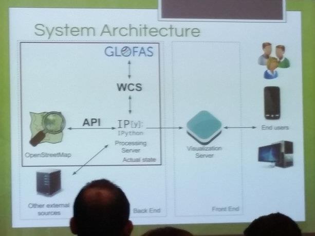
 Understanding users workflows GloFAS current and future data services Fredrik Wetterhall 1 University of Leeds 6 September 2017 Objective of the talk and exercise 1. Demonstrate how GloFAS data is disseminated
OGC at KNMI: Current use and plans
 OGC at KNMI: Current use and plans 4th Workshop on the use of GIS/OGC standards in meteorology 4 th of March 2013, Reading 1. Ernst de Vreede 2. Maarten Plieger Contents 1. ADAGUC 2. Internal applications
Metview and Python - what they can do for each other
 Metview and Python - what they can do for each other Workshop on Python for Earth System Sciences, ECMWF Iain Russell, Fernando Ii, Sándor Kertész, Stephan Siemen Development Section, ECMWF ECMWF November
Metview s new Python interface
 Metview s new Python interface Workshop on developing Python frameworks for earth system sciences. ECMWF, 2018 Iain Russell Development Section, ECMWF Thanks to Sándor Kertész Fernando Ii Stephan Siemen
Serving Large-Scale Coverages - How to Tame an Elephant
 Serving Large-Scale s - How to Tame an Elephant OGC Workshop 2 INSPIRE Conference Edinburgh, 29-jun-2011 Peter Baumann Jacobs University rasdaman GmbH OGC WCS.SWG chair OGC spec editor Sensor & Image Data
Prototyping WCS 2.0 extension for meteorological grid handling
 www.iblsoft.com Prototyping WCS 2.0 extension for meteorological grid handling Michal Weis IBL Pavol Novotný, PhD Prototype developer, IBL Jozef Matula IBL 5 th Workshop on the use of GIS/OGC standards
ECMWF's Next Generation IO for the IFS Model and Product Generation
 ECMWF's Next Generation IO for the IFS Model and Product Generation Future workflow adaptations Tiago Quintino, B. Raoult, S. Smart, A. Bonanni, F. Rathgeber, P. Bauer ECMWF tiago.quintino@ecmwf.int ECMWF
Working with Scientific Data in ArcGIS Platform
 Working with Scientific Data in ArcGIS Platform Sudhir Raj Shrestha sshrestha@esri.com Hong Xu hxu@esri.com Esri User Conference, San Diego, CA. July 11, 2017 What we will cover today Scientific Multidimensional
C3S Data Portal: Setting the scene
 C3S Data Portal: Setting the scene Baudouin Raoult Baudouin.raoult@ecmwf.int Funded by the European Union Implemented by Evaluation & QC function from European commission e.g.,fp7 Space call Selected set
How to run OpenIFS as a shallow water model
 How to run OpenIFS as a shallow water model OpenIFS includes a number of idealised configurations. In this article we explain how to: setup and run a shallow-water model set idealized (e.g. Rossby-Haurwitz
Meteorology and Python
 Meteorology and Python desperately trying to forget technical details Claude Gibert, Europython 2011 Background Meteorology - NWP Numerical Weather Prediction ECMWF European Centre for Medium-Range Weather
Metview 5.0 and Beyond, to its Pythonic Future
 Metview 5.0 and Beyond, to its Pythonic Future MOS 2017, ECMWF Iain Russell, Fernando Ii, Sándor Kertész, Stephan Siemen Development Section, ECMWF ECMWF March 02, 2017 What is Metview? Workstation software
Metview 4 ECMWF s latest generation meteorological workstation
 from Newsletter Number 126 Winter 2010/11 COMPUTING Metview 4 ECMWF s latest generation meteorological workstation doi:10.21957/v4xszl60 This article appeared in the Computing section of ECMWF Newsletter
The challenges of the ECMWF graphics packages
 The challenges of the ECMWF graphics packages Sylvie Lamy-Thépaut Graphics Section ECMWF Slide 1 1 Outline Who are we? - ECMWF - The Graphics Section What are our Missions? - Magics - Metview - Wrep :
Python: Working with Multidimensional Scientific Data. Nawajish Noman Deng Ding
 Python: Working with Multidimensional Scientific Data Nawajish Noman Deng Ding Outline Scientific Multidimensional Data Ingest and Data Management Analysis and Visualization Extending Analytical Capabilities
Uniform Resource Locator Wide Area Network World Climate Research Programme Coupled Model Intercomparison
 Glossary API Application Programming Interface AR5 IPCC Assessment Report 4 ASCII American Standard Code for Information Interchange BUFR Binary Universal Form for the Representation of meteorological
Integrating OGC web services into Metview and Magics++
 Integrating OGC web services into Metview and Magics++ Developing ECMWF s tools for OGC web services Sylvie Lamy-Thépaut, Stephan Siemen, Fernando Ii, Slide 1 Sándor Kertész,Vesa Karhila, Iain Russel Graphics
Beyond Rasters: Introducing The New OGC Web Coverage Service 2.0
 Beyond Rasters: Introducing The New OGC Web Coverage Service 2.0 Peter Baumann Jacobs University Bremen rasdaman GmbH Jacobs University Bremen International, multi-cultural,300+ students, 0 nations, 75%
Generating SVG weather maps and meteorological graphs using Magics++
 Generating SVG weather maps and meteorological graphs using Magics++ Stephan Siemen Graphics Section ECMWF Slide 1 1 Outline What is ECMWF? What is Magics++? How did we implement our SVG output? Some examples
Abstract. Introduction. OGC Web Coverage Service 2.0
 786 Introducing WCS 2.0, EO-WCS, and Open Source Implementations (MapServer, rasdaman, and EOxServer) Enabling the Online Data Access to Heterogeneous Multi-dimensional Satellite Data Christian SCHILLER,
Online intercomparison of models and observations using OGC and community standards
 Online intercomparison of models and observations using OGC and community standards Alastair Gemmell * Jon Blower Keith Haines Adit Santokhee Reading e-science e Centre, Environmental Systems Science Centre,
Best Practices for using OGC WMS with Time-Dependent or Elevation-Dependent Data
 Best Practices for using WMS with Time-Dependent or Elevation-Dependent Data 4 th Workshop on the use of GIS/ standards in meteorology ECMWF, Reading Marie-Francoise Voidrot, Chris Little Co chairs of
TIGGE and the EU Funded BRIDGE project
 TIGGE and the EU Funded BRIDGE project Baudouin Raoult Head of Data and Services Section ECMWF Slide 1 Slide 1 The TIGGE core dataset THORPEX Interactive Grand Global Ensemble Global ensemble forecasts
Interoperability Between GRDC's Data Holding And The GEOSS Infrastructure
 City University of New York (CUNY) CUNY Academic Works International Conference on Hydroinformatics 8-1-2014 Interoperability Between GRDC's Data Holding And The GEOSS Infrastructure Volker Andres Henning
Spatio-Temporal Big Data: - the rasdaman approach
 Spatio-Temporal Big Data: - the rasdaman approach OGRS 2014 Otaniemi, Espoo, Finland, 10 June 2014 Peter Baumann Jacobs University rasdaman GmbH p.baumann@jacobs-university.de [animation: gamingfeeds.com]
ECMWF s Next Generation IO for the IFS Model
 ECMWF s Next Generation IO for the Model Part of ECMWF s Scalability Programme Tiago Quintino, B. Raoult, P. Bauer ECMWF tiago.quintino@ecmwf.int ECMWF January 14, 2016 ECMWF s HPC Targets What do we do?
eccharts Cihan Sahin Slide 1 Meteorological Operational Systems November
 eccharts Cihan Sahin on behalf of the eccharts development team Peter Bispham, Andy Brady, Jose Casado, Ricardo Correa, Tim Orford, Baudouin Raoult, David Richardson, Cihan Sahin, Stephan Slide Siemen,
WCS2.1 Met-Ocean. 16 th Workshop on Operational Systems. Crown copyright Met Office
 WCS2.1 Met-Ocean 16 th Workshop on Operational Systems Crown copyright Met Office A Revolutionary Approach to Multi- Dimensional Data Access of Gridded Datasets Using Current and Proposed OGC Web Coverage
Metview 4 ECMWF s latest generation meteorological workstation
 Metview 4 ECMWF s latest generation meteorological workstation Iain Russell, Stephan Siemen, Fernando Ii, Sándor Kertész, Sylvie Lamy-Thépaut, Vesa Karhila Version 4 builds on the flexible and proven modular
Bruce Wright, John Ward, Malcolm Field, Met Office, United Kingdom
 The Met Office s Logical Store Bruce Wright, John Ward, Malcolm Field, Met Office, United Kingdom Background are the lifeblood of the Met Office. However, over time, the organic, un-governed growth of
ECMWF Copernicus Procurement
 ECMWF Copernicus Procurement Invitation to Tender Copernicus Climate Change Service Volume II Software Development for the Climate Data Store (CDS) Toolbox ITT Ref: C3S_25 ISSUED BY: ECMWF Administration
Gridded Data Speedwell Derived Gridded Products
 Gridded Data Speedwell Derived Gridded Products Introduction Speedwell Weather offers access to a wide choice of gridded data series. These datasets are sourced from the originating agencies in their native
The C3S Climate Data Store and its upcoming use by CAMS
 Atmosphere The C3S Climate Data Store and its upcoming use by CAMS Miha Razinger, ECMWF thanks to Angel Alos, Baudouin Raoult, Cedric Bergeron and the CDS contractors Atmosphere What are C3S and CDS? The
The EC Presenting a multi-terabyte dataset MWF via ER the web
 The EC Presenting a multi-terabyte dataset MWF via ER the web Data Management at the BADC Ag Stephens BADC Data Scientist 11 November 2003 Presentation outline An introduction to the BADC. The project
Urban SIS D4.4 Visualisation report
 Urban SIS D4.4 Visualisation report Issued by: Swedish Meteorological and Hydrological Institute Date: 29/12/2016 Official deadline: 31/12/2016 REF.: C3S_441 Lot3 Urban SIS D4.4 Copernicus Climate Change
Approaches to I/O Scalability Challenges in the ECMWF Forecasting System
 Approaches to I/O Scalability Challenges in the ECMWF Forecasting System PASC 16, June 9 2016 Florian Rathgeber, Simon Smart, Tiago Quintino, Baudouin Raoult, Stephan Siemen, Peter Bauer Development Section,
A brief introduction 1 to retrieving ERA Interim via the web and webapi
 A brief introduction 1 to retrieving ERA Interim via the web and webapi Adrian Tompkins (ICTP), Email: tompkins@ictp.it Last updated May 9, 2017 1 Analysis and Reanalysis Overview For a full description
The EU-funded BRIDGE project
 from Newsletter Number 117 Autumn 2008 COMPUTING The EU-funded BRIDGE project doi:10.21957/t8axr71gg0 This article appeared in the Computing section of ECMWF Newsletter No. 117 Autumn 2008, pp. 29-32.
cdo Data Processing (and Production) Luis Kornblueh, Uwe Schulzweida, Deike Kleberg, Thomas Jahns, Irina Fast
 Luis Kornblueh, Uwe Schulzweida, Deike Kleberg, Thomas Jahns, Irina Fast") cdo Data Processing (and Production) Luis Kornblueh, Uwe Schulzweida, Deike Kleberg, Thomas Jahns, Irina Fast Max-Planck-Institut für Meteorologie, DKRZ September 24, 2014 MAX-PLANCK-GESELLSCHAFT Data
cdo Data Processing (and Production) Luis Kornblueh, Uwe Schulzweida, Deike Kleberg, Thomas Jahns, Irina Fast Max-Planck-Institut für Meteorologie, DKRZ September 24, 2014 MAX-PLANCK-GESELLSCHAFT Data
Metview 4 ECMWF s next generation meteorological workstation
 Metview 4 ECMWF s next generation meteorological workstation Iain Russell Graphics Section ECMWF Slide 1 21 st EGOWS, Reading, 1 4 June 2010 1 What is Metview? (1) Working environment for Operational and
CERA: Database System and Data Model
 CERA: Database System and Data Model Michael Lautenschlager Frank Toussaint World Data Center for Climate (M&D/MPIMET, Hamburg) NINTH WORKSHOP ON METEOROLOGICAL OPERATIONAL SYSTEMS ECMWF, Reading/Berks.,
MIR. ECMWF s New Interpolation Package. P. Maciel, T. Quintino, B. Raoult, M. Fuentes, S. Villaume ECMWF. ECMWF March 9, 2016
 MIR ECMWF s New Interpolation Package P. Maciel, T. Quintino, B. Raoult, M. Fuentes, S. Villaume ECMWF mars-admins@ecmwf.int ECMWF March 9, 2016 Upgrading the Interpolation Package Interpolation is pervasive:
ECMWF New Users Metview Tutorial
 ECMWF New Users Metview Tutorial Author: Date: URL: Iain Russell 06-Mar-2014 08:43 https://software.ecmwf.int/wiki/display/metv/ecmwf+new+users+metview+tutorial 1 of 12 Table of Contents 1 Preparation
Scientific and Multidimensional Raster Support in ArcGIS
 Scientific and Multidimensional Raster Support in ArcGIS Sudhir Raj Shrestha sshrestha@esri.com Brief breakdown Scientific Multidimensional data Ingesting Scientific MultiDim Data in ArcGIS Ingesting and
EVOlution of EO Online Data Access Services (EVO-ODAS) ESA GSTP-6 Project by DLR, EOX and GeoSolutions (2015/ /04)
 ESA GSTP-6 Project by DLR, EOX and GeoSolutions (2015/ /04)") EVOlution of EO Online Data Access Services (EVO-ODAS) ESA GSTP-6 Project by DLR, EOX and GeoSolutions (2015/10 2017/04) 2016 Conference on Big Data from Space - BiDS 16, Tenerife, 15 th -17 th March Evolution
EVOlution of EO Online Data Access Services (EVO-ODAS) ESA GSTP-6 Project by DLR, EOX and GeoSolutions (2015/10 2017/04) 2016 Conference on Big Data from Space - BiDS 16, Tenerife, 15 th -17 th March Evolution
ECMWF point database: providing direct access to any model output grid-point values
 ECMWF point database: providing direct access to any model output grid-point values Baudouin Raoult, Cihan Şahin, Sylvie Lamy-Thépaut ECMWF ECMWF Slide 1 Why a point database? ECMWF main models output
NOAA NextGen IT/Web Services (NGITWS)
") NOAA NextGen IT/Web Services (NGITWS) Robert Bunge (Office of Dissemination) Ryan Solomon (Aviation Weather Center) Steve Olson (Office of Science and Technology) August 24, 2016 ATIEC 2016 Topics Origins
NOAA NextGen IT/Web Services (NGITWS) Robert Bunge (Office of Dissemination) Ryan Solomon (Aviation Weather Center) Steve Olson (Office of Science and Technology) August 24, 2016 ATIEC 2016 Topics Origins
Big changes coming to ECMWF Product Generation system
 Big changes coming to ECMWF Product Generation system European Working Group on Operational meteorological Workstations (EGOWS): 15-17 October 2018 Marta Gutierrez ECMWF Forecast Department Marta.Gutierrez@ecmwf.int
Observations and Measurements as a basis for semantic reconciliation between GRIB and netcdf... and some other ideas.
 Observations and Measurements as a basis for semantic reconciliation between GRIB and netcdf... and some other ideas. Jeremy Tandy 24 th September 2014 Problem statement: interoperability interoperable
The Logical Data Store
 Tenth ECMWF Workshop on Meteorological Operational Systems 14-18 November 2005, Reading The Logical Data Store Bruce Wright, John Ward & Malcolm Field Crown copyright 2005 Page 1 Contents The presentation
Existing Solutions. Operating data services: Climate Explorer ECA&D climate4impact.eu data.knmi.nl
 Existing Solutions Operating data services: Climate Explorer ECA&D climate4impact.eu data.knmi.nl Wim Som de Cerff, KNMI R&D Observations and Data Technology sdecerff@knmi.nl Climate data services at KNMI
Instituting an observation database (ODB) capability in the GSI
 capability in the GSI") Instituting an observation database (ODB) capability in the GSI Jeff Whitaker, Scott Gregory, and Tom Hamill NOAA / ESRL Physical Sciences Division Presentation to Blueprints for Next-Generation Data Assimilation
Instituting an observation database (ODB) capability in the GSI Jeff Whitaker, Scott Gregory, and Tom Hamill NOAA / ESRL Physical Sciences Division Presentation to Blueprints for Next-Generation Data Assimilation
Ocean, Atmosphere & Climate Model Assessment for Everyone
 Ocean, Atmosphere & Climate Model Assessment for Everyone Rich Signell USGS Woods Hole, MA Unidata 2014 DeSouza Award Presentation Boulder, CO : Sep 15, 2014 2 US Integrated Ocean Observing System (IOOS
Metview s new Python interface first results and roadmap for further developments
 Metview s new Python interface first results and roadmap for further developments EGOWS 2018, ECMWF Iain Russell Development Section, ECMWF Thanks to Sándor Kertész Fernando Ii Stephan Siemen ECMWF October
MetOcean Themes in INSPIRE
 MetOcean Themes in INSPIRE Cliquez pour modifier le style du titre 4th Workshop on the use of GIS/OGC standards in meteorology Cliquez pour modifier le style des sous-titres Frédéric du Guillaud masque
Metview Introduction
 Metview Introduction Fernando Ii Slide 1 Meteorological Visualisation Section ECMWF Metview - Introduction June 2013 1 Outline Introduction Interactive usage demo Slide 2 Metview - Introduction June 2013
Multi-Community, Multi-Sensor Maritime Earth Observation DC
 Multi-Community, Multi-Sensor Maritime Earth Observation DC How do you eat the elephant? Gianluca Luraschi EO Project Manager and Application Architect Gianluca.luraschi@emsa.europa.eu SafeSeaNet Ecosystem
Metview BUFR Tutorial. Meteorological Visualisation Section Operations Department ECMWF
 Meteorological Visualisation Section Operations Department ECMWF 05/03/2015 This tutorial was tested with Metview version 4.3.0 and some features might not work for previous versions. Copyright 2015 European
Python Winding Itself Around Datacubes
 Python Winding Itself Around Datacubes FOSDEM 2017, Brussels [co-funded through EU EarthServer-2] Siddhart Shukla, Vlad Merticariu, Peter Baumann Jacobs University rasdaman GmbH baumann@rasdaman.com [gamingfeeds.com]
Introduction to Metview
 Introduction to Metview Fernando Ii, Iain Russell, Sándor Slide Kertész 1 Development Section - ECMWF 1 What is Metview? Retrieve/manipulate/visualise meteorological data Working environment for operational
Manual MARS web viewer
 Manual MARS web viewer 08 July 2010 Document Change Log Issue Date Description of changes 0.1 03-FEB-2009 Initial version 0.2 13-MAR-2009 Manual for viewer version 16-3-2009 1.0 20-MAY-2009 Manual for
Tom Achtor, Tom Rink, Tom Whittaker. Space Science & Engineering Center (SSEC) at the University of Wisconsin - Madison
 at the University of Wisconsin - Madison") Interactive Processing of Multi- and Hyper-spectral Environmental Satellite Data: The Next Generation of McIDAS EUMETSAT-AMS Conf. Amsterdam, NL 27 September 2007 Tom Achtor, Tom Rink, Tom Whittaker Space
Interactive Processing of Multi- and Hyper-spectral Environmental Satellite Data: The Next Generation of McIDAS EUMETSAT-AMS Conf. Amsterdam, NL 27 September 2007 Tom Achtor, Tom Rink, Tom Whittaker Space
Magics support in CDO
 Magics support in CDO Creating of contour, vector and graph plots January 2016 Kameswarrao Modali, Ralf Müller, Uwe Schulzweida Max Planck Institute for Meteorology Contents 1 Introduction 3 2 Building
A JSON format (and tools) for Coverage data. OGC Technical Committee Dublin, Ireland Maik Riechert 22 June 2016
 for Coverage data. OGC Technical Committee Dublin, Ireland Maik Riechert 22 June 2016") Sponsored by Hosted by A JSON format (and tools) for Coverage data OGC Technical Committee Dublin, Ireland Maik Riechert 22 June 2016 What we want Work with coverage data in browsers Standardized webby
Sponsored by Hosted by A JSON format (and tools) for Coverage data OGC Technical Committee Dublin, Ireland Maik Riechert 22 June 2016 What we want Work with coverage data in browsers Standardized webby
A ONE-STOP SERVICE HUB INTEGRATING ESSENTIAL WEATHER AND GEOPHYSICAL INFORMATION ON A GIS PLATFORM. Hong Kong Observatory
 A ONE-STOP SERVICE HUB INTEGRATING ESSENTIAL WEATHER AND GEOPHYSICAL INFORMATION ON A GIS PLATFORM Hong Kong Observatory Mission HONG KONG OBSERVATORY To provide people-oriented quality services in meteorology
Ecography. Supplementary material
 Ecography ECOG-03031 Fordham, D. A., Saltré, F., Haythorne, S., Wigley, T. M. L., Otto-Bliesner, B. L., Chan, K. C. and Brooks, B. W. 2017. PaleoView: a tool for generating continuous climate projections
Putting Your Data on the Map
 Putting Your Data on the Map Cyndy Chandler WHOI Marine Chemistry Department Woods Hole Data Mongers / Ocean Informatics Meeting 4 April 2007 - WHOI Finding the OI in WHOI What is Ocean Informatics? The
The 4-Dimensional Weather Data Cube
 The 4-Dimensional Cube Tom Ryan, FAA Jason Tuell, NWS Bruce Lambert, Lt Col, USAF 12 May 2009 1 Presentation Outline What is the 4-D (Wx) Cube? The 4-D Wx Cube Interagency Plan Demonstrations 2 What is
Proba-V and S3-SYN SNAP Toolbox: status and updates
 Proba-V QWG-07 Proba-V and S3-SYN SNAP Toolbox: status and updates Carsten Brockmann 04.05.2018 SNAP 6 Release January 2018 SNAP http://step.esa.int Version 6 Direct data access (SciHub) integration Plotting
Dl 9 Development and implementation of an IWRMS
 Project no: GOCE -036952 Project acronym: BRAHMATWINN Instrument: Specific Targeted Research Project Thematic Priority: Global Change and Ecosystems Project title: Twinning European and South Asian River
Achieving Interoperability using the ArcGIS Platform. Satish Sankaran Roberto Lucchi
 Achieving Interoperability using the ArcGIS Platform Satish Sankaran Roberto Lucchi Thank you Please fill out the session survey in your mobile app Select [Achieving Interoperability using the ArcGIS Platform]
Version 3 Updated: 10 March Distributed Oceanographic Match-up Service (DOMS) User Interface Design
 User Interface Design") Distributed Oceanographic Match-up Service (DOMS) User Interface Design Shawn R. Smith 1, Jocelyn Elya 1, Adam Stallard 1, Thomas Huang 2, Vardis Tsontos 2, Benjamin Holt 2, Steven Worley 3, Zaihua Ji
Distributed Oceanographic Match-up Service (DOMS) User Interface Design Shawn R. Smith 1, Jocelyn Elya 1, Adam Stallard 1, Thomas Huang 2, Vardis Tsontos 2, Benjamin Holt 2, Steven Worley 3, Zaihua Ji
Web Services at ECMWF
 Web Services at ECMWF Delivering data and graphical products to our Users Sylvie Lamy-Thépaut, Cristian Codorean, Cihan Sahin, Carlos Valiente, Tim Orford ECMWF March 4, 2017 Web services at ECMWF Which
Standards and business models transformations
 Standards and business models transformations Inspire Conference 2017 by Jean Michel Zigna, with support of Elisabeth Lambert, Tarek Habib, Tony Jolibois and Sylvain Marty Collecte Localisation Satellite
WRF-NMM Standard Initialization (SI) Matthew Pyle 8 August 2006
 Matthew Pyle 8 August 2006") WRF-NMM Standard Initialization (SI) Matthew Pyle 8 August 2006 1 Outline Overview of the WRF-NMM Standard Initialization (SI) package. More detailed look at individual SI program components. SI software
WRF-NMM Standard Initialization (SI) Matthew Pyle 8 August 2006 1 Outline Overview of the WRF-NMM Standard Initialization (SI) package. More detailed look at individual SI program components. SI software
Index Introduction Setting up an account Searching and accessing Download Advanced features
 ESGF Earth System Grid Federation Tutorial Index Introduction Setting up an account Searching and accessing Download Advanced features Index Introduction IT Challenges of Climate Change Research ESGF Introduction
Steps towards a Web Data Laboratory: data analysis for the 21 st Century
 Steps towards a Web Data Laboratory: data analysis for the 21 st Century M. Benno Blumenthal International Research Institute for Climate and Society Columbia University http://iridl.ldeo.columbia.edu/
International Civil Aviation Organization THE SECOND MEETING OF SYSTEM WIDE INFORMATION MANAGEMENT TASK FORCE (SWIM TF/2)
") SWIM TF/2 IP/09 Agenda Item 4 09-12/04/18 International Civil Aviation Organization THE SECOND MEETING OF SYSTEM WIDE INFORMATION MANAGEMENT TASK FORCE (SWIM TF/2) Bangkok, Thailand, 09 12 April 2018 Agenda
SWIM TF/2 IP/09 Agenda Item 4 09-12/04/18 International Civil Aviation Organization THE SECOND MEETING OF SYSTEM WIDE INFORMATION MANAGEMENT TASK FORCE (SWIM TF/2) Bangkok, Thailand, 09 12 April 2018 Agenda
OPeNDAP: Accessing HYCOM (and other data) remotely
 remotely") OPeNDAP: Accessing HYCOM (and other data) remotely Presented at The HYCOM NOPP GODAE Meeting By Peter Cornillon OPeNDAP Inc., Narragansett, RI 02882 7 December 2005 8/25/05 HYCOM NOPP GODAE 1 Acknowledgements
OPeNDAP: Accessing HYCOM (and other data) remotely Presented at The HYCOM NOPP GODAE Meeting By Peter Cornillon OPeNDAP Inc., Narragansett, RI 02882 7 December 2005 8/25/05 HYCOM NOPP GODAE 1 Acknowledgements
Current Progress of Grid Project in KMA
 Current Progress of Grid Project in KMA CUG 2006 Kim, Hee-Sik Cray Korea Inc. This Presentation May Contain Some Preliminary Information, Subject To Change Outline KMA s Cray X1E system Relationship between
AWIPS Technology Infusion Darien Davis NOAA/OAR Forecast Systems Laboratory Systems Development Division April 12, 2005
 AWIPS Technology Infusion Darien Davis NOAA/OAR Forecast Systems Laboratory Systems Development Division Plans for AWIPS Next Generation 1 What s a nice lab like you, doing in a place like this? Plans
(Towards) A metadata model for atmospheric data resources
 A metadata model for atmospheric data resources") (Towards) A metadata model for atmospheric data resources Anne De Rudder and Jean-Christopher Lambert Belgian Institute for Space Aeronomy (IASB-BIRA), Brussels The context EU FP7 Ground-based atmospheric
(Towards) A metadata model for atmospheric data resources Anne De Rudder and Jean-Christopher Lambert Belgian Institute for Space Aeronomy (IASB-BIRA), Brussels The context EU FP7 Ground-based atmospheric
IMAGERY FOR ARCGIS. Manage and Understand Your Imagery. Credit: Image courtesy of DigitalGlobe
 IMAGERY FOR ARCGIS Manage and Understand Your Imagery Credit: Image courtesy of DigitalGlobe 2 ARCGIS IS AN IMAGERY PLATFORM Empowering you to make informed decisions from imagery and remotely sensed data
Desarrollo de una herramienta de visualización de datos oceanográficos: Modelos y Observaciones
 Desarrollo de una herramienta de visualización de datos oceanográficos: Modelos y Observaciones J. Fernandez, J. Lopez, I. Carlos, F. Jerez, F. Hermosilla, M. Espino SIMO, LIM-UPC, CIIRC FIELD_AC 7 th
Catalog-driven, Reproducible Workflows for Ocean Science
 Catalog-driven, Reproducible Workflows for Ocean Science Rich Signell, USGS, Woods Hole, MA, USA Filipe Fernandes, Centro Universidade Monte Serrat, Santos, Brazil. 2015 Boston Light Swim, Aug 15, 7:00am
J1.6 MONITORING AND ANALYZING THE GLOBAL OCEAN OBSERVING SYSTEM WITH THE OBSERVING SYSTEM MONITORING CENTER
 J1.6 MONITORING AND ANALYZING THE GLOBAL OCEAN OBSERVING SYSTEM WITH THE OBSERVING SYSTEM MONITORING CENTER Kevin M. O'Brien 1*,S. Hankin 2, R. Schweitzer 3, K. Kern 4, M. Little 4,T. Habermann 5, N. Auerbach
Introduction to ECMWF resources:
 Introduction to ECMWF resources: Computing and archive services. and how to access them Paul Dando User Support Paul.Dando@ecmwf.int advisory@ecmwf.int University of Reading - 23 January 2014 ECMWF Slide
NOTICE. This document is only one section of a larger document. All sections together collectively form the NNEW Documentation.
 NOTICE This document is only one section of a larger document. All sections together collectively form the NNEW Documentation. Please be advised that: This section may need to be interpreted in the context
The Semantic Sensor Network Ontology A Generic Language to Describe Sensor Assets
 Ben Ridge Road Weather Station, South Esk River Catchment, Tasmania The Semantic Sensor Network Ontology A Generic Language to Describe Sensor Assets Holger Neuhaus Michael Compton Commonwealth Scientific
GSKY: A scalable, distributed geospatial data-server
 GSKY: A scalable, distributed geospatial data-server Pablo R. Larraondo, Sean Pringle, Joseph Antony, Ben Evans pablo.larraondo@anu.edu.au National Computational Infrastructure, Australian National University
Observation trends: Expectations from European Comission regarding data exchange and interoperability
 Observation trends: Expectations from European Comission regarding data exchange and interoperability Marcin Wichorowski (IO PAN), Sławomir Sagan (IO PAN), Declan Dunne (UCC MaREI), John Barton (UCC-TYNDALL)
Interpolation. Computer User Training Course Paul Dando. User Support. ECMWF 25 February 2016
 Interpolation Computer User Training Course 2016 Paul Dando User Support advisory@ecmwf.int ECMWF 25 February 2016 1 Contents Introduction Overview of Interpolation Spectral Transformations Grid point
ISO/IEC JTC 1 N 11274
 ISO/IEC JTC 1 N 11274 ISO/IEC JTC 1 Information technology Secretariat: ANSI (USA) Document type: Title: Status: Officer's Contribution SC 32 Chairman Presentation to the November 2012 JTC 1 Plenary Meeting
McIDAS-V Tutorial Installation and Introduction updated September 2015 (software version 1.5)
") McIDAS-V Tutorial Installation and Introduction updated September 2015 (software version 1.5) McIDAS-V is a free, open source, visualization and data analysis software package that is the next generation
McIDAS-V Tutorial Installation and Introduction updated September 2015 (software version 1.5) McIDAS-V is a free, open source, visualization and data analysis software package that is the next generation
An Outline of a WCS2.0 MetOC Profile for discussion. Crown copyright Met Office
 An Outline of a WCS2.0 MetOC Profile for discussion ECMWF 2013 The aims of this discussion To Agree the basic principles i.e. Use cases using the Met Ocean dwg. Form a working group to look at creating
_ LUCIADFUSION V PRODUCT DATA SHEET _ LUCIADFUSION PRODUCT DATA SHEET
 _ LUCIADFUSION PRODUCT DATA SHEET V2016 LuciadFusion is the solution for efficient and effective use of geospatial data. It allows you to organize your data so that each user has one-click access to a
Getting Started with the JS API for Multidimensional Image Services. Hong Xu, Wenxue Ju
 Getting Started with the JS API for Multidimensional Image Services Hong Xu, Wenxue Ju Outline How to publish a multidimensional image service - ArcGIS multidimensional data model JS API for multidimensional
Oceanic Observatory for the Iberian Shelf
 Oceanic Observatory for the Iberian Shelf B.Vila Barcelona, 26th September 2016 Objectives: The Project Improve the oceanic observation at the North Western Iberian coast (meteorological, oceanographical
Levenberg-Marquardt minimisation in ROPP
 Ref: SAF/GRAS/METO/REP/GSR/006 Web: www.grassaf.org Date: 4 February 2008 GRAS SAF Report 06 Levenberg-Marquardt minimisation in ROPP Huw Lewis Met Office, UK Lewis:Levenberg-Marquardt in ROPP GRAS SAF
COM INTRO 2017: GRIB Decoding - Solutions to practicals. Solution to Practical 1: using grib_dump and grib_ls
 COM INTRO 2017: GRIB Decoding - Solutions to practicals Solution to Practical 1: using grib_dump and grib_ls 1. To list the GRIB messages in % grib_ls edition centre typeoflevel level datadate steprange