USER GUIDE. Created by MyCRM Ltd. emap. Installation and Configuration
|
|
|
- Barnaby Hawkins
- 5 years ago
- Views:
Transcription
1 USER GUIDE Created by MyCRM Ltd emap Installation and Configuration MyCRM Ltd 1/1/2014
2 2 About This Guide This guide is intended for CRM system administrators who wish to understand the installation, configuration and customization of emap. Installation The trial of emap can be installed by following these steps: Register for an account at Once logged in, get a Product Key for emap Download the MyCRM Licence Manager installer The installer will guide you through the process of installing the MyCRM Licence Manager in your CRM instance Once you have the Licence Manager installed, open up your CRM instance and go to Settings -> Extensions -> MyCRM Licence Manager Click the Install New Product button and enter your emap licence key The Licence Manager will guide you through the process of installing the emap solution Network Requirements emap uses Bing webservices and Javascript controls to perform geocoding and provide the end-user map interface. The product also requires an occasional licence check to MyCRM-hosted servers. To that end, the following endpoints will need to be made available for connection when the CRM server or end-users are behind a firewall or proxy: Server-side The following endpoints will need to be made available to the servers which run the CRM front-end and Plugin Sandbox service: dev.virtualearth.net the Bing geocoding webservice. This should be made available on port 443 (https). licencedev.mycrmservice.net the MyCRM licencing webservice. Also port 443 (https). Where possible, it is best to use wildcards for the above domains when defining rules (e.g. *.virtualearth.net). Client-side The following endpoints will need to be made available to end-users of CRM when using the emap controls: (*all* subdomains on this address should be enabled)
3 3 Default Data Once emap is installed in your CRM you may install the default maps and geocode configurations to get up and running quickly. This is recommended for demonstration and trial purposes. Experienced emap administrators can skip this step and build out their own configurations if preferred. Go to Settings -> Customizations -> Solutions Double-click the emap solution to open the Solution Click the Install Default Data button (found under Configuration if the Solution does not open it by default): The default data installation should only take a few seconds to a minute. Once complete, you re ready to go! User Permissions and Licencing All users (including System Administrators) of the front-end maps (either the Master Map or Form Maps) require the emap User security role, which is installed as part of the emap solution. If the emap User role is not applied to a user, that user will see an error message when they attempt to navigate to one of the map areas. When a user with the emap User role navigates to either the Master Map or a Form Map, they will be assigned a licence if there is a licence slot available. You can manage which users are assigned licences via the MyCRM Download Centre app in CRM. Note that if you remove a user from a licence slot via the Download Centre app, you must also remove the emap User role from them otherwise they will be re-assigned a licence the next time they navigate to a map display.
4 4 Geocoding Geocoding is the process of converting a street address to latitude and longitude co-ordinates to pinpoint a location on a map. In order to display a CRM entity s location on a map, an entity must have enough relevant address information for the Bing Maps geocoding service to successfully geocode its location. A postal code alone will be enough to geocode to the postal area, but more accurate geolocation will only be possible where an entity has a house/business address number, street name, city and so on. The more accurate your address information in your CRM entities is, the more accurate the resulting location on the map will be. Geocoding in CRM with emap In order to geocode entity addresses in CRM, you must first set up an Entity Geocode Configuration for that entity. Once emap is installed, you will find Entity Geocode Configurations in Settings -> Extensions: The emap default data contains geocode configurations for Account, Contact, Lead and User. These are the four main entities that include latitude and longitude fields out-of-the-box. By default, the configurations use the Address1_ fields to geocode.
5 5 Creating and Editing Entity Geocode Configurations An Entity Geocode Configuration takes fields from any CRM entity and maps them to fields used by the Bing Maps geocoding service. Here, for example, is the default Account configuration: The fields in the drop-down boxes are your entity fields in CRM. The field labels refer to the address field as used by Bing. For instance, Address Line 1 on the Bing service is mapped to the Address 1: Street 1 field on the Account in CRM. Note: Only text fields are supported for the address field mappings. The Latitude and Longitude mappings are the fields that the resulting Lat/Long co-ordinates from Bing are written to in CRM. Most default entities in CRM that have address fields also have corresponding Latitude and Longitude fields. If you are mapping a custom entity s address fields, you will need to create Latitude and Longitude fields to store the geocode information. Note: Latitude and Longitude fields must be defined as Floating Point Number types. Default Country The text content of the Default Country field is used during geocoding when the mapped Country field is blank for the record being geocoded. Using Account as an example, the geocoding process will first look at the Address 1: Country/Region field for data. If there is no data, the default country will be used. Scenario: If your company is based in the UK, and you mostly work with Accounts in the UK your users may not always fill in the Country field with UK. The Country field might only be used when an Account is outside of the UK. Supplying UK as the Default Country will then restrict geocoding to addresses within the UK (where a Country is not entered on the entity), providing more accurate results for the majority of your Accounts in CRM.

6 6 The Geocoding Process Once some Entity Geocoding Configurations have been defined, there are two ways to begin the Geocoding process. Manual Geocoding of all entities for a configuration On the Entity Geocoding Configuration form, there is a tool to run that geocoding configuration against all matching entities in CRM: Once all of the required fields have been mapped, simply hit the Bulk Geocode command button to begin the geocoding process. This will run against all records of the entity type defined in the Entity drop-down. You will see progress counters as the geocoding process runs. Records Examined: A count of records that the tool has processed. Records Skipped: A record will be skipped if a) there is not enough address information to perform a geocode; or b) the record already has information in the Latitude or Longitude fields. You can force a regeocode on records that already have a Latitude or Longitude by checking the Re-geocode already geocoded records box before running the geocode. Successful Geocodes: The number of records that were successfully geocoded by the Bing Maps Geocoding service. Unsuccessful Geocodes: The number of records that could not be geocoded. This will be due to bad address information in one or more of the address fields.
7 7 The Geocoding plugin emap includes a plugin that runs on Create and Update of any entity that has an Entity Geocode Configuration set up for it. A geocode will only be attempted if one or more of the entity s address fields (as configured) are updated, or included when the entity is created. By default, the plugin runs synchronously, so the geocoding result will happen as soon as a record is updated. It may take several seconds to perform the geocode. The Create plugin step will run on a data import so you can be sure that imported records will be geocoded providing that the correct address fields are mapped and imported successfully. The plugin can be disabled via Settings -> Customizations -> Customize the System if required. The plugin does not need to be enabled for the manual geocoding process, as described above.


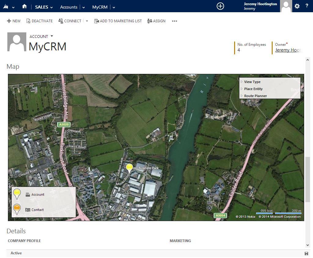
8 8 Map Configuration emap allows you to flexibly create new maps that can be displayed in one or more of three places: The Master Map, initially installed in Sales -> Maps: On a dashboard: On an entity form:
9 9
10 10 Creating a New Map In Settings -> Extensions -> Map Configurations, click the New ribbon button. You will be given a blank Map Configuration to fill out: Name: A friendly name for your map. For example: Active Accounts, Open Cases etc. Available on Master Map: When checked, the new map will be available to select on the Master Map in Workplace. It will be available to all emap users to view. You should not check this option if you are creating a Map that will be displayed on an entity form (see later).
11 11 Is Data Paged: (On by default) emap loads data from your CRM view onto the map either with or without paging. With paging turned on, records are loaded a maximum of 1000 at a time, according to the area you are viewing on the map. Panning and/or zooming will refresh the data accordingly. With paging tuned off, all data is loaded up-front when the map loads. This can take a long time with views that have more than 10,000 records. Some map features (Entity Distance Filtering and Route Filtering) require all records to be loaded to work. If Data Paging is off when one of these features is used, all records will be temporarily loaded. Default Map View: The default Bing Maps imagery that will be used on the map. Either Road, Aerial or Automatic. Enable Map View Selection: Determines whether the end-user will be able to change the Map imagery as set in the Default Map View option. Enable Pan and Zoom: If disabled, the end-user will not be able to pan and zoom on the map the map will be locked and zoomed on the available pins. This option might be useful where a map is used only for display purposes such as on a dashboard or entity form. Heat Map Enabled / On by default / Default Intensity: Allows users to switch the map to display a heat map of records. See the user guide for more info on heat maps. Heat maps requires an HTML5/Canvas compatible browser. Click to Open Popup: (Off by default) When enabled, the pin popup is opened with a left-click, as opposed to just hovering the mouse. Recommended for touch-screen devices. Shrink Pins Below Zoom Level: Sets a zoom level below which a small version of the pin icon will be used. The map has a zoom level of 0-20, with 0 being zoomed out the furthest. Recommend setting this to around 8 with maps that have more than a few records. Default Pan and Zoom: (Form maps only) When displaying a map on an entity form, it is sometimes useful to have the map automatically centre on the entity s pin, at a predefined zoom level. Switch to Form Entity to accommodate this. Show Legend: Determines whether the legend (showing pin colours and entity names) will be visible on the map. Enable Layer Show / Hide: When disabled, the end-user will not be able to toggle visibility of individual map layers. Enable Layer Filter Change: When disabled, the end-user will not be able to alter the data filtering on a layer, other than by using emaps features. Enable Features: A master option that will completely enable or disable map Features. If disabled, the Features bar on the right of the map display will not be shown, regardless of whether an individual Feature is enabled or disabled. See the user guide for explanation of the individual features. Local Search: Enable the Local Search feature, and set it on or off by default. See the user guide for more information on Local Search.
12 12 Layers: A regular related entity grid that allows you to add and remove layers from the map (see below).
13 13 Map Layers Map layers are at the heart of emap s flexible ability to display data on a map. Each Map Configuration must have at least one Layer in order to display data. Each layer is linked to an entity type and determines the set of data that emap will display for the selected entity. Layers are so-called because they are drawn on the map in order from top (layer order 0) to bottom (layer order n). For instance, if you have a layer with display order 0 containing Account data, and a layer with display order 1 containing Contact data, the Account pins will appear on top of the Contact pins when displayed on the map. Data Sources Layers user CRM Views to determine which data is displayed on the layer. For example, selecting the Active Accounts view when setting up an Account layer will only show Active Accounts. Selecting My Accounts as the view for a layer will display the Accounts that are owned by the end-user that is viewing the map. You could set up custom views in CRM to show different sets of data for the selected entity. There is one exception to using Views: when setting up a map that will be displayed on an entity form, you may wish to have a layer that will show the location of only the entity that has been opened. In this case you would use the Form Entity data source. Geocode Sources By default, layers will take their location from the latitude and longitude fields as set up in the Entity Geocode Configuration for the layer s selected entity. There are times when you will need to get geocode information from a related entity. Example: Opportunities contain no address information. You may however wish to create a layer that displays Opportunities on a map. In order to get a location for an Opportunity, you would look at the related Customer entity. This will allow the layer to place Opportunity pins at the geocoded location of the Contact or Account that is provided as a Customer on the Opportunity. Form Entity Filtering Scenario: I wish to create a map that will be displayed on the Account form. I want this map to display the location of the Account that I open, but I also want to display the location of all the Contacts associated with that Account We can use the special Form Entity Filter layer option to provide this functionality. In the given scenario, the Map would have two layers: One Account layer that has a Form Entity data source, and a Contact Layer that uses the Active Contacts view as its data source. On the Contact Layer, we would select Parent Account as the Form Entity Filter. This will then display Active Contacts where the Parent Account is the Account displayed on the open form. Behind the scenes, the filter takes the ID of the entity of the current form and adds it to the selected view s pre-created filter. Form Entity Filtering is a powerful feature that is useful any time a map is added to a form for an entity that has a one-to-many relationship with another entity.
14 14 Creating a New Map Layer Map Layers can only be created via the related entity grid of a Map Layer Configuration. When you click the New Map Layer button, the following form is displayed: Map Configuration: The map that this layer will be displayed on. This lookup will be set automatically. Layer Order: The order that the layer will be displayed in. 0 is the topmost layer. When this value is changed for one layer on a map - or if a layer is deleted - the rest of the layers for that map will have their display orders updated. Entity: The entity type that will be displayed on this layer. Layer Display Name: A friendly name for the map layer, as displayed in the Legend. Defaults to the entity name. Data Source: Either View or Form Entity. See the previous page for a description of Data Sources. View: Only available if the Data Source is set to View. The view that will be used to gather data to display on the Layer. Allow user to change view: When enabled, a drop-down box will appear below the layer in the map Legend to allow the user to select a different view to display. This includes the user s Saved Views. Geocode Source: Either This Entity or Related Entity. See the previous page for a description of Geocode Sources.
15 15 Related Entity: Only available if Geocode Source is set to Related Entity. The related entity that the latitude/longitude data is taken from. Form Entity Filter: The lookup that is filtered by the ID of the form that the map is placed on. Only used if the layer is on a map that is placed on an entity form. See the previous page for a description of Form Entity Filtering. Pin Type: Either: Basic Color, Webresource Field or Appointment (appointment pin type only available on an Appointments layer) Pin Color: The pin that will be used for this layer when the Pin Type is Basic Color. Webresource Url: Choose a field from the entity that will contain the URL of a custom pin to load. When the map loads, the pin icon for this entity will be taken from the corresponding field. The URL can be CRM relative /images/my_pin.png if loading from a Web Resource, or absolute if loading from an external site. Loading the pin image from a URL is very powerful. For example, you could have small pins with users faces on them when setting up a User layer, or a custom coloured pin that is set by a workflow when an entity is updated (think: Job Status for a Case). Appointment: When setting up an Appointments layer, the Appointment pin type is a special pin that will show the number of days until the appointment (or negative if the appointment has passed). Today s appointments will be highlighted in green. Display Name Field: The field that will be used as a title when displaying the popup box for this layer on the map. Recommended fields to use would be Name for Account/Lead, Full Name for Contact etc. Display Fields: The extra fields that will be displayed on the popup box on the map. You can include any fields you like here, and change the display order using the up/down arrows. Most common fields to include would be relevant address fields, but you could use any fields that would be useful information for the end-user have at a glance. The fields selected here are also used as columns when using the List Creator function. See the user guide for more information.
16 16 Adding Maps in CRM So, you ve created a new Map and added Layers to it. Now it s time to get it displayed to end-users in CRM. Maps that are enabled for display on the Master Map will automatically be available on the Master Map under Workplace -> My Work. The end-user can choose between any available Master Maps by using the Map Selector dropdown box. Adding Maps to entity forms and dashboards requires a little customization, and will be detailed below. Map IDs In order to place a map on a form or dashboard, we need to know the Map ID. Once a Map Configuration has been created, the Map ID is displayed on the Map Configuration form, as shown: The Map ID can be copied from here and used in the detailed scenarios below.
17 17 Removing or Relocating the Master Map The Master Map is created via a standard CRM Site Map entry and can be removed or relocated using any number of CRM 2011 Sitemap Editors available, or by exporting the sitemap and editing it manually. The Master Map is added to the site map via the myce_/emap_master.html web resource. The following image shows the Master Map sitemap entry in a popular free Site Map editing tool:
18 18 Changing the Default Master Map By default, the Master Map will display the first map in the list of Maps that are available for display on the Master Map, sorted alphabetically by Name. You can specify a default map by adding to the Web Resource URL in the site map. In the screenshot below, we use the Sitemap Editor tool to add?data=<map ID> to the myce_/emap_master.html url: Here, we used the ID copied from the Active Accounts map in the Map IDs section screenshot on the previous page and appended it to the myce_/emap_master.html web resource URL. As a result, the Active Accounts map is now shown by default on the Master Map page.
19 19 Displaying a Map on a Dashboard You can use the CRM Dashboard Editor to place Maps on a dashboard section. Select Web Resource when editing a dashboard section, and then set the Web Resource s properties as follows: Web Resource: Select the myce_/emap.html resource (note: do not use the myce_/emap_master.html resource on a dashboard section) Name / Label: Can be set as required. It is not recommended to set the Display label on the Dashboard option, as this causes cut-off issues when used with an HTML web resource. Custom Parameter(data): Paste your copied Map ID into this box. The corresponding map will be used in this dashboard section. You may display as many maps as you like on one dashboard. It is recommended that Features are turned off when displaying a map on a dashboard, especially if the map is constrained to a small portion of the screen. If the map needs to be fully-functional, consider a single map dashboard with a large display area for the dashboard section.
 that a new Tab is set up for the Map to be displayed in.")
20 20 Displaying a Map on an Entity Form Open up the form editor for the CRM entity as normal. It is recommended (but not required) that a new Tab is set up for the Map to be displayed in. Create a new form section and insert a web resource via the Insert tab: Set the Web Resource properties as follows:
21 21 Web Resource: Select the myce_/emap.html resource (note: do not use the myce_/emap_master.html resource on a form) Name / Label: Can be set as required. Custom Parameter(data): Paste your copied Map ID into this box. The corresponding map will be used on this form. On the Formatting tab:
22 22 Layout: Two columns. Row Layout: 6 rows is the absolute minimum space required for a map, and it is recommended to use Automatically expand to use available space. Scrolling: As necessary. Border: Off.
USER GUIDE. Created by MyCRM Ltd. emap. User Guide
 USER GUIDE Created by MyCRM Ltd emap User Guide MyCRM Ltd 1/1/2014 2 About This Guide This guide is intended for CRM users who wish to understand how to use emap and get the most out of its advanced location
USER GUIDE PowerMap CRM
 USER GUIDE PowerMap CRM 2013 2015 Contents Configuring PowerMap Setting up Entities for Geocoding Geocoding Existing Records Advanced Settings Bing Maps Credentials Initial Latitude Initial Longitude Initial
MAPLYTICS User Manual
 MAPLYTICS User Manual Page 1 of 70 Contents INTRODUCTION... 3 LANGUAGE SUPPORT... 4 MAPLYTICS CONFIGURATION (PERSONALIZATION)... 5 INDIVIDUAL RECORD MAP... 5 DETAIL MAP... 8 Plot: There are five different
USER MANUAL. Quick Maps TABLE OF CONTENTS. Version: 2.1
 USER MANUAL Quick Maps Version: 2.1 Compatibility: Microsoft Dynamics CRM 2016(v8.0) and above TABLE OF CONTENTS Introduction... 2 Benefits of Quick Maps... 2 Prerequisites... 2 Installation & Configuration...
Tutorial for Lane County Mapping Applications
 Tutorial for Lane County Mapping Applications Contents Overview... 2 Tools... 2 Navigation Tools... 3 Display Tools... 5 Information Tools... 6 Sharing Tools... 7 Common Tasks... 9 Identify or Show Data
USER MANUAL. Quick Maps TABLE OF CONTENTS. Version: 1.0
 USER MANUAL Quick Maps Version: 1.0 Compatibility: Microsoft Dynamics CRM 2016(v8.0) and above TABLE OF CONTENTS Introduction... 2 Benefits of Quick Maps... 2 Prerequisites... 2 Installation & Configuration...
Maplytics User Manual MAPLYTICS User Manual
 MAPLYTICS User Manual Page 1 of 57 Contents INTRODUCTION... 3 LANGUAGE SUPPORT:... 4 INDIVIDUAL RECORD MAP:... 5 DETAIL MAP... 8 By Location... 9 By Region... 12 By Drawing.... 13 By Territory... 15 By
Market Insight Geo Mapping User Guide v1.0
 Market Insight Geo Mapping v1.0 D&B Market Insight Geo Mapping Manual Version: 1.0 Software Version: System: 2017 Q3 Training (UK) Contents Introduction... 1 Data Structure... 2 How to Login... 3 Map Options...
INTERACTIVE MAP TUTORIAL
 Wisconsin Breeding Bird Atlas II INTERACTIVE MAP TUTORIAL General Information There are two versions of the map, the PC Desktop Version, and the Mobile/Mac Version. Most of this guide will assume you are
This document describes the various enhancements and modifications to DRM Windows that occurred between versions and
 This document describes the various enhancements and modifications to DRM Windows that occurred between versions 8.3.260 and 9.1.270. New Feature: Customer Mapping The mapping feature lets you interact
VISAV Ltd. 20/01/2015
 NEIGHBOURHOOD ALERT User Dashboard Help Manual VISAV Ltd. 20/01/2015 Documentation for the Neighbourhood Alert: User Dashboard. 1 Contents 1 Contents... 1 2 Overview... 2 3 Accessing the Dashboard... 2
NJUNS Users Guide.
 NJUNS Users Guide www.njuns.com The National Joint Utilities Notification system, NJUNS, is a national organization of member utilities formed for the purpose of improving the coordination of joint ventures.
Vision-e 19 Gloria Lane Fairfield, NJ
 Version.0 Section Page 1.0 Manage User Licenses 3 1.1 Geocoding Your Records 4 1.2 Enabling Custom Objects 5 1.3 Create a Map 5 1.4 Import Report 6 1.5 Edit a Map 6 1.6 Clone a Map 7 1.7 Delete a Map 7
Viewing the Data 3 Turning Layers On / Off 4 Navigation Toolbar 5 Layout Toolbar 7 Identify Tool 8 Find Tool 10 Measure Tool 12 Go To XY Tool 14
 1 Viewing the Data 3 Turning Layers On / Off 4 Navigation Toolbar 5 Layout Toolbar 7 Identify Tool 8 Find Tool 10 Measure Tool 12 Go To XY Tool 14 Transparency Tool 16 Markup Tools 19 ArcMap Markup Tools
New Visual Design for IRON HQ Release Notes
 New Visual Design for IRON HQ Release Notes Based on customer feedback, NetSuite, our platform for HQ, has improved key areas of the user interface including readability, navigation, data entry, and dashboard
How to use the DuPage County Parcel Viewer Interactive Web Mapping Application.
 How to use the DuPage County Parcel Viewer Interactive Web Mapping Application. Parcel Viewer URL: URL: http://gis.dupageco.org/parcelviewer/ Initial View (And frequently asked questions) Parcel Search
Address Management User Guide. PowerSchool 8.x Student Information System
 PowerSchool 8.x Student Information System Released July 2014 Document Owner: Documentation Services This edition applies to Release 8.0.1 of the PowerSchool software and to all subsequent releases and
Quick Guide FAST HR. For more resources, including a guide on FAST HR codes, visit # Instructions Screenshot
 Tips & tricks This quick guide describes basic navigation within the FAST HR reporting tool, including how to use filter options, format columns and export reports. For more resources, including a guide
U N I V E R S I T Y O F K E N T U C K Y. efacts 2-click Interactive Building Information Map ~ Help Guide ~ Revised January 20, 2016
 U N I V E R S I T Y O F K E N T U C K Y efacts 2-click Interactive Building Information Map ~ Help Guide ~ Revised January 20, 2016 Contents BUILDING SEARCH... 3 A. FIND A CAMPUS LOCATION... 3 GRAPHICAL
Connecting Software. CB Mobile CRM - iphone. User Manual
 CB Mobile CRM - iphone User Manual Summary This document describes the ios app Mobile CRM, its functionality and features available. The document is intended for end users as user manual to provide knowledge
Installation and Configuration Manual
 Installation and Configuration Manual IMPORTANT YOU MUST READ AND AGREE TO THE TERMS AND CONDITIONS OF THE LICENSE BEFORE CONTINUING WITH THIS PROGRAM INSTALL. CIRRUS SOFT LTD End-User License Agreement
Space Management_. Tips and Tricks_ UniSA All Staff
 Space Management_ Tips and Tricks_ UniSA All Staff Contents Click to go to that location in the document: Favourite views... 3 Quick find Room on plan... 4 Quick link to Room record... 5 View plan details
The Connector Version 2.0 Microsoft Project to Atlassian JIRA Connectivity
 The Connector Version 2.0 Microsoft Project to Atlassian JIRA Connectivity User Manual Ecliptic Technologies, Inc. Copyright 2011 Page 1 of 99 What is The Connector? The Connector is a Microsoft Project
MAPLYTICS User Manual
 MAPLYTICS User Manual Page 1 of 115 Contents INTRODUCTION... 5 LANGUAGE SUPPORT... 6 MAPLYTICS CONFIGURATION (PERSONALIZATION)... 6 MAPLYTICS SECURITY TEMPLATE... 7 INDIVIDUAL RECORD MAP... 10 Steps to
Atrio Map. Installation and User Guide
 Atrio Map Version 8 Installation and User Guide Atrio 6001 N. Adams Road, Suite 285 Bloomfield Hills, Michigan 48304-1547 (248) 594-1500 - www.atriocrm.com Table of Contents Introduction... 3 Requirements/Compatibility...
City of La Crosse Online Mapping Website Help Document
 City of La Crosse Online Mapping Website Help Document This document was created to assist in using the new City of La Crosse online mapping sites. When the website is first opened, a map showing the City
Greenville County Internet Mapping System User s Guide
 Greenville County Internet Mapping System User s Guide Version 2.0 Greenville County Geographic Information Systems May 30, 2006 Table of Contents NAVIGATING TO THE ONLINE MAPPING APPLICATIONS...- 3 -
ALES Wordpress Editor documentation ALES Research websites
 ALES Wordpress Editor documentation ALES Research websites Contents Login... 2 Website Dashboard... 3 Editing menu order or structure... 4 Add a new page... 6 Move a page... 6 Select a page to edit...
Creating Dashboard Widgets. Version: 16.0
 Creating Dashboard Widgets Version: 16.0 Copyright 2017 Intellicus Technologies This document and its content is copyrighted material of Intellicus Technologies. The content may not be copied or derived
ebooks in OASIS ebooks in OASIS
 ebooks in OASIS ebooks in OASIS Slide 2 - Agenda AGENDA ebooks in OASIS Administration Manage Group What platforms & licenses do you have access to? Preferred platforms & licenses Manage Account Individual
SmartBar for MS CRM 2013
 SmartBar for MS CRM 2013 Version 2013.15, March 2014 Installation and User Guide (How to install/uninstall and use SmartBar for MS CRM 2013) The content of this document is subject to change without notice.
Welcome to Book Display Widgets
 Welcome to Book Display Widgets Book Display Widgets allow you to create virtual book displays on your website, where covers link to that item s record in your catalog. As a subscriber to Ebook Central
Reset Cursor Tool Clicking on the Reset Cursor tool will clear all map and tool selections and allow tooltips to be displayed.
 SMS Featured Icons: Mapping Toolbar This document includes a brief description of some of the most commonly used tools in the SMS Desktop Software map window toolbar as well as shows you the toolbar shortcuts
Xrm.Location AddOn User Manual
 Microsoft Dynamics CRM 2013/2015/2016 Xrm.Location AddOn User Manual Table of Contents Overview... 3 Configuring Xrm.Location... 4 GeoLocating Dynamics Crm Entities... 7 Placing GeoCoded Entities on a
Creating Dashboard. Version: 7.3
 Creating Dashboard Version: 7.3 Copyright 2015 Intellicus Technologies This document and its content is copyrighted material of Intellicus Technologies. The content may not be copied or derived from, through
User Manual InfoGrow Corporation
 CRM SMARTMAP DESKTOP User Manual Table of Contents Opening the SmartMap Desktop Application...2 Searching Options...2 Basic Map Navigation...3 Completed Search Options...5 Product Support... 11 pg.1 Opening
CRM F1 for Microsoft Dynamics
 CRM F1 for Microsoft Dynamics Installation and Configuration Guide www.crfm1.com info@crmf1.com Table of Contents Overview...1 System Requirements..1 Installing and Configuring CRM F1 for Microsoft Dynamics
Welcome to Book Display Widgets
 Welcome to Book Display Widgets Book Display Widgets allow you to create virtual book displays on your website, where covers link to that item s record in your catalog. Bring your own lists of books, or
Release 28 - Alpha Tracker Release Notes
 Release 28 - Alpha Tracker Release Notes New Features / Changes (from SVN2841 to SVN3056) 1. With the introduction of GDPR, there are some important new features now available in Alpha Tracker. There is
Using Syracuse Community Geography s MapSyracuse
 Using Syracuse Community Geography s MapSyracuse MapSyracuse allows the user to create custom maps with the data provided by Syracuse Community Geography. Starting with the basic template provided, you
Manual for v Last updated - 4/2/ P age
 Manual for v6.1.6 Last updated - 4/2/2015 1 P age CONTENTS General Interface and Usage... 5... 5 NAVIGATION... 5 GRIDS... 6 ACTION BUTONS... 8 Overview... 8 USER ACCOUNTS... 8 Overview... 8 Setting up
Table of contents. DMXzone Google Maps 2 DMXzone
 Table of contents Table of contents... 1 About... 2 Features in Detail... 3 The Basics: Inserting Google Maps on a Page... 20 Advanced: Control Google Maps with Behaviors... 27 Advanced: Track Your Current
USER GUIDE PowerGrid CRM 2013/2015
 USER GUIDE PowerGrid CRM 2013/2015 Contents Configuring PowerGrid Activity Setup Security Roles Navigating to PowerGrid Grid Entity View Search Bar Reading Pane In-line Edit Action Toolbar Opening a Record
Sage Getting Started Guide. September 2017
 Sage 100 2018 Getting Started Guide September 2017 2017 The Sage Group plc or its licensors. All rights reserved. Sage, Sage logos, and Sage product and service names mentioned herein are the trademarks
12d Synergy V4 Release Notes. 12d Synergy V4 Release Notes. Prerequisites. Upgrade Path. Check Outs. Scripts. Workspaces
 12d Synergy V4 Release Notes V4 contains a large number of features. Many of these features are listed in this document, but this list may not be exhaustive. This document also contains pre-requisites
User Interface (Windows Edition)
") User Interface (Windows Edition) User Interface (Windows Edition) 1 Overview 1.1 1.2 1.3 1.4 1.5 1.6 1.7 1.8 1.9 1.10 1.11 Top Level Navigation 4 Navigation Menus 5 Expanding Navigation Category Menus
User Interface (Windows Edition) User Interface (Windows Edition) 1 Overview 1.1 1.2 1.3 1.4 1.5 1.6 1.7 1.8 1.9 1.10 1.11 Top Level Navigation 4 Navigation Menus 5 Expanding Navigation Category Menus
Dashboard Instructions
 Dashboard Instructions The instructions below provide a brief overview of some of the tools available to you as you navigate the COMPASS performance dashboard. The dashboard was created to provide Communities
Travel Insurance and Registrations System (TIRS) Get the data you need: Workplace, Dashboard and Views
 Get the data you need: Workplace, Dashboard and Views") Travel Insurance and Registrations System (TIRS) Get the data you need: Workplace, Dashboard and Views Version 1.0 Page 1 of 19 Contents 1 Getting the data you need out of CRM... 3 1.1 Views... 3 1.2 Ordering
Travel Insurance and Registrations System (TIRS) Get the data you need: Workplace, Dashboard and Views Version 1.0 Page 1 of 19 Contents 1 Getting the data you need out of CRM... 3 1.1 Views... 3 1.2 Ordering
Address Management User Guide. PowerSchool 6.0 Student Information System
 User Guide PowerSchool 6.0 Student Information System Released June 2009 Document Owner: Document Services This edition applies to Release 6.0 of the PowerSchool Premier software and to all subsequent
DYNAMICS 365 BUSINESS PROCESS VISUALIZATION USING VISIO
 MICROSOFT LABS JANUARY 10, 2019 DYNAMICS 365 BUSINESS PROCESS VISUALIZATION USING VISIO A Solution to create a Microsoft VISIO template by consuming the configured entity values from the CRM entity record.
Propel PRO User Guide
 Propel PRO User Guide Propel PRO Version 3.2.0a Page 1 Welcome to the latest version of Propel PRO which offers fast performance and easy navigation. Please refer to this user guide for common features
User Guide. General Navigation
 User Guide General Navigation Table of Contents INTRODUCTION 2 TECHNICAL REQUIREMENTS 3 Screen Display for Laptop 3 Screen Display for Desktop PC 3 NAVIGATION 4 Contact Us 4 Log Out 4 Menu > Sub Menu Display
Eurostat Regions and Cities Illustrated: Usage guide
 Eurostat Regions and Cities Illustrated: Usage guide With Regions and Cities Illustrated, you can easily visualise regional indicators and view data for regions you are most interested in. This interactive
Astra Scheduling Grids
 Astra Scheduling Grids To access the grids, click on the Scheduling Grids option from the Calendars tab. A default grid will be displayed as defined by the calendar permission within your role. Choosing
1. Introduction What is DayLite Notes... 2
 Table of Contents 1. Introduction... 2 1.1. What is DayLite... 2 1.2. Notes... 2 2. Getting Started... 2 2.1. Accessing DayLite... 2 2.2. How to Bookmark Site... 3 2.3. How to Add Short Cut to Home Screen...
GEOCIRRUS 3D Viewer. User Manual: GEOCIRRUS 3D Viewer Document version 1.6 Page 1
 GEOCIRRUS 3D Viewer Page 1 Table of Contents 3D Viewer Functionality... 3 Line of Sight (LoS)... 4 Identify... 8 Measurement... 9 3D Line Measure Tool... 10 3D Area Measure Tool... 11 Environment... 12
Imagine. Create. Discover. User Manual. TopLine Results Corporation
 Imagine. Create. Discover. User Manual TopLine Results Corporation 2008-2009 Created: Tuesday, March 17, 2009 Table of Contents 1 Welcome 1 Features 2 2 Installation 4 System Requirements 5 Obtaining Installation
DEVELOPMENT ASSISTANCE DATABASE FOR COMOROS (DAD COMOROS)
") DEVELOPMENT ASSISTANCE DATABASE FOR COMOROS (DAD COMOROS) ANALYTICAL INTERFACE USER MANUAL Version 1.3 COPYRIGHT 2001-2014 SYNERGY INTERNATIONAL SYSTEMS INC ALL RIGHTS RESERVED DAD COMOROS ANALYTICAL INTERFACE
DEVELOPMENT ASSISTANCE DATABASE FOR COMOROS (DAD COMOROS) ANALYTICAL INTERFACE USER MANUAL Version 1.3 COPYRIGHT 2001-2014 SYNERGY INTERNATIONAL SYSTEMS INC ALL RIGHTS RESERVED DAD COMOROS ANALYTICAL INTERFACE
Starting Your SD41 Wordpress Blog blogs.sd41.bc.ca
 Starting Your SD41 Wordpress Blog blogs.sd41.bc.ca The web address to your blog starts with blogs.sd41.bc.ca/lastnamefirstinitial (eg. John Smith s blog is blogs.sd41.bc.ca/smithj) All work is done in
IP4 - Running reports
 To assist with tracking and monitoring HRIS recruitment and personnel, reports can be run from Discoverer Plus. This guide covers the following process steps: Logging in... 2 What s changed? Changed reference
Release Notes V9.5 (inc V9.4) Release Notes. Phone: Fax:
 Release Notes. Phone: Fax:") Release Notes V9.5 (inc V9.4) 2016 Release Notes Phone: 01981 590410 Fax: 01981 590411 E-mail: information@praceng.com RELEASE NOTES These Release Notes give you information regarding changes, modifications
Release Notes V9.5 (inc V9.4) 2016 Release Notes Phone: 01981 590410 Fax: 01981 590411 E-mail: information@praceng.com RELEASE NOTES These Release Notes give you information regarding changes, modifications
OnCOR Silverlight Viewer Guide
 Getting Around There are many ways to move around the map! The simplest option is to use your mouse in the map area. If you hold the left button down, then click and drag, you can pan the map to a new
Quick Start Guide - Contents. Opening Word Locating Big Lottery Fund Templates The Word 2013 Screen... 3
 Quick Start Guide - Contents Opening Word... 1 Locating Big Lottery Fund Templates... 2 The Word 2013 Screen... 3 Things You Might Be Looking For... 4 What s New On The Ribbon... 5 The Quick Access Toolbar...
HBS Training - IT Solutions. PlanWeb. Introduction
 HBS Training - IT Solutions PlanWeb Introduction CONTENTS Logging on to the system...3 The PlanWeb Window...5 The Tool Bar...6 The Status Bar...6 The Map Window...6 The Information Window...7 Changing
Unit 8: Working with Actions
 Unit 8: Working with Actions Questions Covered What are actions? How are actions triggered? Where can we access actions to create or edit them? How do we automate the sending of email notifications? How
Using Sitecore 5.3.1
 Using Sitecore 5.3.1 An End-User s Guide to Using and Administrating Sitecore Author: Sitecore Corporation Date: December 12, 2007 Release: Rev. 1.0 Language: English Sitecore is a registered trademark.
STORE LOCATOR USER GUIDE Extension version: 1.0 Magento Compatibility: CE 2.0
 support@magestore.com sales@magestore.com Phone: +1-606-657-0768 STORE LOCATOR USER GUIDE Extension version: 1.0 Magento Compatibility: CE 2.0 Table of Contents 1. INTRODUCTION 3 Outstanding Features...3
Veco User Guides. Grids, Views, and Grid Reports
 Veco User Guides Grids, Views, and Grid Reports Introduction A Grid is defined as being a list of data records presented to the user. A grid is shown generally when an option is selected from the Tree
USER MANUAL. Calendar 365 TABLE OF CONTENTS. Version: 4.0
 USER MANUAL TABLE OF CONTENTS Introduction... 1 Benefits of Calendar 365... 1 Pre-requisites... 2 Installation... 2 Installation Steps... 2 Configuration Steps... 5 Calendar Management... 19 Calendar Activities...
Fusion. CBR Fusion MLS Level 1 Core Functions. Class Handout
 Fusion 1 CBR Fusion MLS Level 1 Core Functions Class Handout GETTING STARTED IN FUSION Logging On and Off To log on to Fusion MLS: 1. Type your user name in the User ID box. 2. Type your password in the
edirectory Change log
 edirectory 11.2.00 Change log Arca Solutions 7138 Little River Turnpike #1825 Annandale, VA 22003 www.arcasolutions.com 1. What s new 1. Sponsors can now add a video to their classifieds ads 2. Sponsors
TRAINING GUIDE. Lucity Webmap 2017r2
 TRAINING GUIDE Lucity Webmap 2017r2 Web Map The Lucity Web Map provides a way for users to see and work with their asset and work data. This allows them to see relationships between objects and plan work
WA L KT H R O U G H 1
 WA L KT H R O U G H 1 udig Install and Introduction 08 June 2008 TABLE OF CONTENTS 1Goals...3 2Installing and Running The udig Application...4 3Online Documentation and Tutorials...8 3.1Help Categories...9
Astra Scheduling Grids
 Astra Scheduling Grids To access the grids, click on the Scheduling Grids option from the Calendars tab. A default grid will be displayed as defined by the calendar permission within your role. Choosing
Forms/Distribution Acrobat X Professional. Using the Forms Wizard
 Forms/Distribution Acrobat X Professional Acrobat is becoming a standard tool for people and businesses to use in order to replicate forms and have them available electronically. If a form is converted
Managing Files & Folders
 Managing Files & Folders 1 Navigation Pane 2 Back, Forward, and Up Buttons 3 Ribbon 4 Address Bar or Navigation Bar 5 File List 6 Column Headings 7 Search Box 8 Status Bar 9 Preview Pane Identify parts
Vertisee Help Interface and Tools VERTISEE HELP. Interface and Tools. McElhanney Consulting Services Ltd Page 1
 VERTISEE HELP Interface and Tools McElhanney Consulting Services Ltd. 2016 Page 1 Contents Browser Interface... 3 Bookmark Tool... 4 Basemap... 5 Coordinate Display Tool... 6 Edit Tool... 7 Find Coordinates
Free ebooks ==>
 www.ebook777.com Table of Contents Free ebooks ==> www.ebook777.com Copyright Excel Apps Maps People Graph Other Lessons www.ebook777.com Mastering Excel Chart Apps Mark Moore Copyright 2015 by Mark Moore.
TRAINING GUIDE. Mobile for Administrators Part 3 - GIS
 TRAINING GUIDE Mobile for Administrators Part 3 - GIS Mobile for Administrators - GIS One of the critical components of mobile is GIS, and it can also be the most complex. The mobile GIS maps are designed
Omeka: A tool for building online exhibits, archives, mapping, and digital humanities research
 Omeka: A tool for building online exhibits, archives, mapping, and digital humanities research Why Omeka? Omeka is an easy way to display student projects, faculty/student research, and other types of
Lucas County Engineer s GIS Maps User Guide
 Lucas County Engineer s GIS Maps User Guide The Web Map Interface On the left hand side of the screen, you will see the Legend of the layers shown in the map. If you click on Details, you will see just
Quick Reference Card Effort Planning System (EPS) Faculty DOE Review & Processing
 Faculty DOE Review & Processing") Process: This Quick Reference Card (QRC) contains brief, direct instructions for faculty members to access, review and process their DOEs in the UK Effort Planning System (EPS). More detailed information
Process: This Quick Reference Card (QRC) contains brief, direct instructions for faculty members to access, review and process their DOEs in the UK Effort Planning System (EPS). More detailed information
SmartBar for MS CRM 2015/2016 and Dynamics 365
 v.2.2, November 2016 SmartBar for MS CRM 2015/2016 and Dynamics 365 PowerSearch (How to work with PowerSearch for MS CRM 2015/2016 and Dynamics 365) The content of this document is subject to change without
USING ITEM SYNC FINESTRA POS
 USING ITEM SYNC FINESTRA POS POSitec is pleased to provide the Item Sync program to support the review and apply process for items presented based on your Pharmasave My Catalogue subscription. Item Sync
Lionbridge Connector for Sitecore. User Guide
 Lionbridge Connector for Sitecore User Guide Version 4.0.2 March 28, 2018 Copyright Copyright 2018 Lionbridge Technologies, Inc. All rights reserved. Lionbridge and the Lionbridge logotype are registered
Lionbridge Connector for Sitecore. User Guide
 Lionbridge Connector for Sitecore User Guide Version 4.0.5 November 2, 2018 Copyright Copyright 2018 Lionbridge Technologies, Inc. All rights reserved. Lionbridge and the Lionbridge logotype are registered
Guide to Mapping Website (Public) December 2016 GC_236594
 December 2016 GC_236594") Guide to Mapping Website (Public) December 2016 GC_236594 Table of Contents Guide to Mapping Website (Public)... 1 December 2016... 1 Quick Start... 3 Map Layers... 4 How do I?... 5 Draw on the Map...
Guide to Mapping Website (Public) December 2016 GC_236594 Table of Contents Guide to Mapping Website (Public)... 1 December 2016... 1 Quick Start... 3 Map Layers... 4 How do I?... 5 Draw on the Map...
Layout and display. STILOG IST, all rights reserved
 2 Table of Contents I. Main Window... 1 1. DEFINITION... 1 2. LIST OF WINDOW ELEMENTS... 1 Quick Access Bar... 1 Menu Bar... 1 Windows... 2 Status bar... 2 Pop-up menu... 4 II. Menu Bar... 5 1. DEFINITION...
Overview. Setting Up. Geospatial Centre University of Waterloo November 2015
 Overview ArcGIS Online is a web-based mapping and app-building site created by Esri, the world leader in GIS software. In an effort to empower users of all levels to create interactive maps and applications
Emote 1.0 Users Manual
 Emote 1.0 Users Manual Part No: 141318 Rev A 2018 Eventide Inc., One Alsan Way, Little Ferry, NJ, 07643 USA 1 Table of Contents Introduction... 3 Downloading the Installer... 3 Making Sure Your H9000 Hardware
With ClaroIdeas you can quickly and easily create idea maps using a combination of words, symbols and pictures.
 Welcome to ClaroIdeas ClaroIdeas is a fresh tool to support the creation and editing of concept maps or idea maps using visual and audio components. It has been specifically developed to support people
Open Source Cloud Map User Guide
 Open Source Cloud Map User Guide Table of Contents Map Page... 1 Static Mercator Map... 1 Customizable Map... 1 Title Bar... 2 Toolbar... 2 Non Toolbar Navigation... 3 Map Window... 3 Layers / Legend Window...
RAPIDMAP Geocortex HTML5 Viewer Manual
 RAPIDMAP Geocortex HTML5 Viewer Manual This site was developed using the evolving HTML5 web standard and should work in most modern browsers including IE, Safari, Chrome and Firefox. Even though it was
CRM FOR PROFESSIONALS MOBILE USER GUIDE.
 CRM FOR PROFESSIONALS MOBILE USER GUIDE www.templetonsolutions.com Table of Contents 1. Introduction... 2 2. Install the App... 3 3. Use the App... 5 4. Accounts... 12 5. Contacts... 16 6. Opportunities...
Blue Form Builder extension for Magento 2
 Blue Form Builder extension for Magento 2 User Guide Version 1.0 Table of Contents I) Introduction......5 II) General Configurations....6 1) General Settings.....7 2) ReCaptcha... 8 III) Manage Forms......
Access Groups. Collect and Store. Text Currency Date/Time. Tables Fields Data Type. You Your Friend Your Parent. Unique information
 Tutorial A database is a computerized record keeping system used to collect, store, analyze and report electronic information for a variety of purposes. Microsoft Access is a database. There are three
Learn how to login to Sitefinity and what possible errors you can get if you do not have proper permissions.
 USER GUIDE This guide is intended for users of all levels of expertise. The guide describes in detail Sitefinity user interface - from logging to completing a project. Use it to learn how to create pages
Office 365 Portal, OneDrive, & Delve
 Office 365 Portal, OneDrive, & Delve Training Packet Welcome to Technology Solution s Office 365, OneDrive, and Delve training! We will use this packet as a guide throughout today s training. We ll introduce
Contents. Mapping. Mapping 2. Constituent Density Map 3 Address Geocodes 4 Map Entities 4 Map Instances 8
 Mapping Last Updated: 08/05/2016 for ResearchPoint 4.91 Contents Mapping 2 Constituent Density Map 3 Address Geocodes 4 Map Entities 4 Map Instances 8 chapter 1: MAPPI NG Mapping To geographically locate
MYOB EXO Business Services
 MYOB EXO Business Services Release Notes 1.3 SP1 Contents Introduction 1 What s New in this Release?... 1 Installation 2 Pre-Install Requirements... 2 Installing the EXO Business Services... 2 Setting