OGC Simple Features (for SQL and XML/GML)
|
|
|
- Deirdre Fletcher
- 6 years ago
- Views:
Transcription
1 Daniel Wirz, Department of Geography - GIS Division, University of Zurich mailto:wirz@geo.unizh.ch January 2004
2 What,...? Introduction Develop publicly available geoprocessing specifications. Open interfaces and protocols defined by OpenGIS Specifications support interoperable solutions that geo-enable the Web, wireless and location-based services, and mainstream IT, and empower technology developers to make complex spatial information and services accessible and useful with all kinds of applications. dw
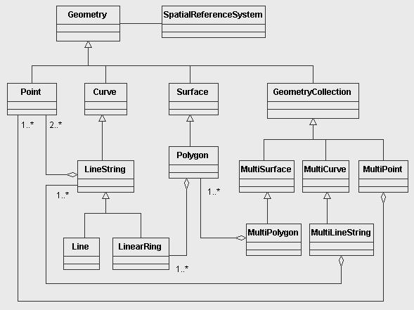
3 Geometry Object Model Introduction Conceptual model DCP-neutral, not SQL specific defines geometries and operations/methods on them Geometry is an abstract class Instantiable subclasses in essence: Points A point in 2-dimensional space Lines are linear edges between two points Linestrings are connected lines (end-point is start-point of next line) Linear Rings are closed Linestrings (last end-point is first start-point ) Polygons Surface within a Linear Ring, potentially excluding inner Linear Rings Uniform Collections of concrete Types dw
4 Introduction dw
5 Introduction Limitations of the Simple Features Geometry Object Model No explicit declaration of topological relations Only 2-dimensional geometries Only linear geometries No Rasterdata dw
6 ..., why,... Introduction Interoperability Share representation of geometric properties of spatial features GI for the Mainstream Extend the market dw
7 ..., who,... Introduction OpenGIS Consortium Members ESRI Mapinfo Cadcorp IBM Informix Oracle... dw
8 ..., and how? Introduction Features to be stored in tables with geometry-valued columns: Main characteristics Each feature constitutes one row in a feature table The feature table contains one or more geometry-valued columns Non-spatial attributes mapped to SQL92 datatypes Spatial attributes mapped onto columns of additional geometric datatypes To be accessed by ODBC dw
9 Two (three) possible implementations for SQL: Implementation Specification for ANSI SQL92 SQL92 using numeric SQL types for geometry storage SQL92 using binary SQL types for geometry storage (WKB GEOMETRY) SQL92 with geometry types Required Tables and Views (SQL92): Feature tables Feature table metadata views GEOMETRY SPATIAL REFERENCE SYSTEMS,... Geometry tables COLUMNS, dw
10 Fig 2.13/ p2-20 Feature tables: Implementation Specification for ANSI SQL92 SQL92 Feature tables 1/3 CREATE TABLE <feature-name> ( <FID name> <FID type>, <feature attributes> <other FID type> REFERENCES <other feature view>,... <geometry attribute 1> <GID type>,... PRIMARY KEY <FID name>,... FOREIGN KEY <geometric attribute 1> REFERENCES <geometry-table-name-1>, FOREIGN KEY <FID relation name> REFERENCES <FEATURE table> <other FID name>,... ) dw
11 Feature table metadata views: Implementation Specification for ANSI SQL92 GEOMETRY COLUMNS ID of feature table SRS ID type of storage (0 = normalized; 1 = WKB) type of geometry (0 = GEOMETRY; 1 = POINT; = MULTIPOLYGON) coordinate dimension of column ID of geometry table Navigation info for normalized geometry storage SPATIAL REFERENCE SYSTEMS dw
12 Implementation Specification for ANSI SQL92 SQL92 Feature tables 2/3: Numeric Geometry SQL types Geometry Tables or Views: CREATE TABLE <table name> ( GID NUMBER NOT NULL, -- ID of Geometry ESEQ INTEGER NOT NULL, -- multiple components within a geometry ETYPE INTEGER NOT NULL, -- (1 = Point, 2 = LineString, 3 = Polygon) SEQ INTEGER NOT NULL, -- row-sequence to define a geometry component X1 <ordinate type>, Y1 <ordinate type>,... <repeated for each ordinate, repeated for each point> X<max_ppr> <ordinate type>, Y<max_ppr> <ordinate type>,..., <attribute name> <attribute type> CONSTRAINT GID_PK PRIMARY KEY (GID, ESEQ, SEQ) ) dw
13 Implementation Specification for ANSI SQL92 SQL92 Feature tables 3/3: Binary Geometry Geometry Tables: CREATE TABLE <table name> ( GID NUMBER NOT NULL PRIMARY KEY, XMIN <ordinate type>, YMIN <ordinate type>, XMAX <ordinate type>, YMAX <ordinate type>, WKB_GEOMETRY VARBINARY, -- Blob? <attribute name> <attribute type> ) The bounding box allows for spatial indexing without accessing the WKB GEOMETRY. dw
14 Implementation Specification for ANSI SQL92 SQL92 Feature tables with geometry types Fig 2.15/ p2-26 Just a subset of SQL92-implementation outlined above: Abstract Data Types (SQL Type extensions) Specification standardizes Types (names, geometric definitions) Functions (names, signature, geometric definitions) Blackbox -access through SQL-functions only (Encapsulation) dw
15 Feature table metadata views: Implementation Specification for ANSI SQL92 GEOMETRY COLUMNS: 1 row for each geometry column in DB ID of feature table SRS ID type of geometry coordinate dimension of column Geometries are assigned to SRS at construction time, SRS-check at insertion time Example: PointFromText(pointTaggedText String, SRID Integer): Point (pointtaggedtext is in Well-known Text-Representation of Geometry) p dw
16 Component Specifications Implementation in Oracle Spatial Chapter 3 of OGC s Simple Feature Specification for SQL provides detailed instructions on how to implement each one of the three suggested alternatives. dw
17 Oracle Spatial Implementation in Oracle Spatial Provides: A schema (MDSYS) that prescribes the storage, syntax, and semantics of supported geometric data types A spatial indexing mechanism A set of operators and functions for performing area-of-interest queries and spatial join queries Administrative utilities... dw
18 Oracle Spatial Implementations Implementation in ESRI SDE Spatial supports two mechanisms, or models, for representing geometries: The relational model uses a table with a predefined set of columns of type NUMBER and one or more rows for each geometry instance. corresponds to OGC s SF for SQL - numeric SQL92 types The object-relational model uses a table with a single column of type MDSYS.SDO GEOMETRY and a single row per geometry instance. corresponds to OGC s SF for SQL - SQL with Geometry Types Oracle recommends using the object-relational model! Some advantages: Additional geometry types: arcs, circles, compound polygons, compound line strings, and optimized rectangles. Performance is greatly improved. dw

19 ESRI SDE Implementation in Postgres/PostGIS ESRI was the first vendor to complete the conformance tests with fully functional, commercial off-the-shelf software: SDE v Implementation: Normalized schema and SQL data types dw
20 Implementation in XML: GML 1 and 2 Postgres/PostGIS An OpenSource Database System supporting OGC SF Thomy Hächler dw
21 Implementation in XML: GML 1 and 2 GML - Geography Markup Language An XML-implementation specification of the Simple Features XML Extensible Markup Language XML gets increasingly popular for integrating heterogenous distributed systems. (Web Services) Dedicated to exchanging (and storing) interoperable data Easy to parse (strict syntax-rules), language neutral, readable for machines and humans Hierarchical content model: Formalism is standardized, but the actual model must/can be defined to match application-specific requirements. XML is a Meta-Language designed to define Markup Languages dw
22 Implementation in XML: GML 1 and 2 GML 1 and 2 still use the (limited) Geometry Model of Simple Features: GML = Simple Features for XML GML3 is expected to support Rasterdata, 3D-Geometries, Topology, etc. GML gets the highest attention of all OGC standards. Apparently it drives the further development even at the conceptual level of Simple Features. GML is designed as data-modeling markup language. It does not provide built-in visualization, but it works well with other XML-technologies dedicated for that purpose, i.e. Scaleable Vector Graphics (SVG). dw
23 Implementation in XML: GML 1 and 2 GML - Geography Markup Language: GML Implementation GML 1.0 based on a Document Type Definition GML 2.0 based on a set of XML-schemas Type system can be extended in an object oriented manner Standardized Geometry schema Standardized XLINK schema for declaring references between resources Application schema to be custom built dw
24 Implementation in XML: GML 1 and 2 GML-2 Example A fictive example from the GML specification. Namespaces: location According to GML Geometry schema, Dean, nickname Defined in application schema. <Dean> <familyname>smith</familyname> <age>42</age> <nickname>smithy</nickname> <nickname>bonehead</nickname> <gml:location> <gml:point> <gml:coord><gml:x>1.0</gml:x><gml:y>1.0</gml:y></gml:coord> </gml:point> <gml:location> </Dean> dw
25 Implementation in XML: GML 1 and 2 Two real world applications of GML: OS MasterMap UK s national mapping agency Ordnance Survey, uses GML for distributing UK digital maps: GDI NRW Testbed Geodaten-Infrastruktur Nordrhein-Westfalen (GDI) This project examplifies the intention to broaden the market for digital geographic information. It is dedicated not only to GI-specialists but to the general public! dw
26 Implementation in XML: GML 3 Commercial systems with GML support No official OGC certification programme for GML-conformance yet. Many GIS applications do provide some level of GML-export/import facilities. Some vendors already do offer products based on OGC s Web Feature Server Specification: Cadcorp Cadcorp SIS Feature Server Ionic IONIC WFS Framework Web Edition, IONIC Suite for ORACLE 8i/9i Cubewerx CubeServ (WFS) Galdos Data Management Suite dw
27 Implementation in XML: GML 3 GML Version 3 Not so simple anymore pages of specification, more than 1000 new tags, finalized in Jan 2003 limited backward compatibility Modularity: Few (or no) products are expected to support the full standard. Packaging tool creates a tailored schema containing only the required components from the GML core schemas Beyond Simple Features ISO TC211 Conformity Temporal information Nonlinear Geometry Topology dw
28 Implementation in XML: GML 3 Topology Mathematically speaking... Definition.... Topology describes the properties of objects which are invariant under continuous deformation. For example, a circle is topologically equivalent to an ellipse because one can be transformed into the other by stretching. In geographic modelling, the foremost use of topology is in accelerating computational geometry. Remark. In most cases we will be more interested in topological relationships between different features rather than the topological properties of a features individual geometries. dw
29 Implementation in XML: GML 3 GML3 conceptual Model for Topology Volume Topology The GML3 Conceptual Model for Topology describes the correspondence of topological and geometric relationships in up to 3 dimensions. according to Topic 1 of the OGC Abstract Specification (ISO DIS 19107) There are four instantiable classes: Node (0D) Edge (1D) Face (2D) TopoSolid (3D) dw
SVENSK STANDARD SS-ISO :2004. Geografisk information Hantering av enklare objekt Del 2: SQL-gränssnitt (ISO :2004, IDT)
") SVENSK STANDARD Fastställd 2004-09-24 Utgåva 1 Geografisk information Hantering av enklare objekt Del 2: SQL-gränssnitt (ISO 19125-2:2004, IDT) Geographic information Simple feature access Part 2: SQL
SVENSK STANDARD Fastställd 2004-09-24 Utgåva 1 Geografisk information Hantering av enklare objekt Del 2: SQL-gränssnitt (ISO 19125-2:2004, IDT) Geographic information Simple feature access Part 2: SQL
XML and Inter-Operability in Distributed GIS
 XML and Inter-Operability in Distributed GIS KIM Do-Hyun and KIM Min-Soo, Republic of Korea Key words: GML(Geography Markup Language), Interoperability, GIS. SUMMARY Web GIS (Geographic Information Systems)
International Organization for Standardization Technical Committee 211 (ISO/TC211)
") Esri Support for Geospatial Standards: Open Geospatial Consortium (OGC) International Organization for Standardization Technical Committee 211 (ISO/TC211) An Esri White Paper April 2015 Copyright 2015
Esri Support for Geospatial Standards: Open Geospatial Consortium (OGC) International Organization for Standardization Technical Committee 211 (ISO/TC211) An Esri White Paper April 2015 Copyright 2015
GML, WFS and SVG: A New Frontier of Internet GIS
 GML, WFS and SVG: A New Frontier of Internet GIS Zhong-Ren Peng Director Center for Advanced Spatial Information Research Associate Professor Department of Urban Planning University of Wisconsin-Milwaukee
Open Geospatial Consortium Inc.
 Open Geospatial Consortium Inc. Date: 2016-12-05 Reference number of this OGC document: OGC 07-036r1 Version: 3.2.2 Category: OpenGIS Standard Editor: Clemens Portele OpenGIS Geography Markup Language
Open boundaries in GIS
 Open boundaries in GIS OpenGIS and the SDO and SDE implementation Godefridus C. Cattenstart Dissertation submitted in part fulfilment of requirements for the degree of Master of Science in Geographical
Esri Support for Geospatial Standards
 APRIL 2017 ArcGIS Is Open and Interoperable Esri Support for Geospatial Standards Copyright 2017 Esri All rights reserved. Printed in the United States of America. The information contained in this document
An introduction and overview of Geography Markup Language
 An introduction and overview of Geography Markup Language Lecturer: Dr Dan Cornford d.cornford@aston.ac.uk http://wiki.aston.ac.uk/dancornford CS3210, Geographic Information Systems, Aston University,
A GML-Based Open Architecture for Building A Geographical Information Search Engine Over the Internet
 A GML-Based Open Architecture for Building A Geographical Information Search Engine Over the Internet Jianting Zhang Le Gruenwald School of Computer Science The University of Oklahoma U.S.A. ggruenwald@ou.edu
Oracle. Oracle Spatial 11g Essentials. 1z Version: Demo. [ Total Questions: 10] Web:
![Oracle. Oracle Spatial 11g Essentials. 1z Version: Demo. [ Total Questions: 10] Web:](/thumbs/90/101573895.jpg "Oracle. Oracle Spatial 11g Essentials. 1z Version: Demo. [ Total Questions: 10] Web:") Oracle 1z0-595 Oracle Spatial 11g Essentials Version: Demo [ Total Questions: 10] Web: www.myexamcollection.com Email: support@myexamcollection.com IMPORTANT NOTICE Feedback We have developed quality product
Oracle 1z0-595 Oracle Spatial 11g Essentials Version: Demo [ Total Questions: 10] Web: www.myexamcollection.com Email: support@myexamcollection.com IMPORTANT NOTICE Feedback We have developed quality product
Beyond PostGIS. New developments in Open Source Spatial Databases. Karsten Vennemann. Seattle
 New developments in Open Source Spatial Databases Karsten Vennemann Seattle Talk Overview Intro Relational Databases PostGIS JASPA INGRES Geospatial MySQL Spatial Support HatBox a user space extension
The Interoperability of Location-Tracking Service based on Geographic Information
 The Interoperability of Location-Tracking Service based on Geographic Information Do Hyun KIM and Byung Tae JANG, Korea Key words: Interoperability, Location-Tracking, GIS SUMMARY Tracking Service based
SERVO - ACES Abstract
 1 of 6 12/27/2004 2:33 PM 2 of 6 12/27/2004 2:33 PM Implementing GIS Grid Services for the International Solid Earth Research Virtual Observatory Galip Aydin (1), Marlon Pierce (1), Geoffrey Fox (1), Mehmet
Esri Support for Geospatial Standards: OGC and ISO/TC211. An Esri White Paper May 2015
 Esri Support for Geospatial Standards: OGC and ISO/TC211 An Esri White Paper May 2015 Copyright 2015 Esri All rights reserved. Printed in the United States of America. The information contained in this
FDO Data Access Technology at a Glance
 Autodesk Geospatial FDO Data Access Technology at a Glance Work seamlessly with your geospatial data whatever the format 1 The Challenge The growing need for openness and interoperability between traditional
Geospatial Intelligence Interoperability Through Standards Gordon C.Ferrari Chief, Content Standards and Interoperability Division
 Geospatial Intelligence Interoperability Through Standards Gordon C.Ferrari Chief, Content Standards and Interoperability Division 15 May 2002 NIMA Vision and Mission Statements National Imagery and Mapping
Introduction to Geodatabase and Spatial Management in ArcGIS. Craig Gillgrass Esri
 Introduction to Geodatabase and Spatial Management in ArcGIS Craig Gillgrass Esri Session Path The Geodatabase - What is it? - Why use it? - What types are there? - What can I do with it? Query Layers
Using ESRI data in Autodesk ISD Products
 GI13-3 Using ESRI data in Autodesk ISD Products 1.5 hr. Class 02-Dec-03 3:30pm - 5:00pm Session Description: We will focus on using data in a variety of ESRI formats within the Autodesk GIS product line,
Spatio-Temporal Data Exchange Standards
 2003 IEEE. Personal use of this material is permitted. However, permission to reprint/republish this material for advertising or promotional purposes or for creating new collective works for resale or
Welcome. to Pre-bid meeting. Karnataka State Spatial Data Infrastructure (KSSDI) Project, KSCST, Bangalore.
 Project, KSCST, Bangalore.") Welcome to Pre-bid meeting Karnataka State Spatial Data Infrastructure (KSSDI) Project, KSCST, Bangalore. DEVELOPMENT OF KARNATAKA STATE SPATIAL DATA INFRASTRUCTURE (KSSDI) PROJECT Objective: To develop
Welcome to Pre-bid meeting Karnataka State Spatial Data Infrastructure (KSSDI) Project, KSCST, Bangalore. DEVELOPMENT OF KARNATAKA STATE SPATIAL DATA INFRASTRUCTURE (KSSDI) PROJECT Objective: To develop
Leveraging OGC Services in ArcGIS Server. Satish Sankaran, Esri Yingqi Tang, Esri
 Leveraging OGC Services in ArcGIS Server Satish Sankaran, Esri Yingqi Tang, Esri GIS Creating and Managing Geo Information Products - Proprietary - Open Specifications - Standards Dissemination of Geo
Regarding the quality attributes, the architecture of the system must be:
 The SDSS System Overview This chapter gives an overview of the software architecture of the RiskChanges SDSS system. One of the objectives within the project is the development of a SDSS system for probabilistic
Tutorial International Standards. Web Map Server (WMS) & Web Feature Server (WFS) Overview
 & Web Feature Server (WFS) Overview") ISO/TC 211 17 th Plenary & Associated Meetings Berlin, Germany, DIN Institute / 2003-10-31 Advisory Group on Outreach Tutorial International Standards Web Map Server (WMS) & Web Feature Server (WFS) Overview
ISO/TC 211 17 th Plenary & Associated Meetings Berlin, Germany, DIN Institute / 2003-10-31 Advisory Group on Outreach Tutorial International Standards Web Map Server (WMS) & Web Feature Server (WFS) Overview
OGC,, WMS and WFS. Strategic Goals. The Vision and the Mission
 The Vision and the Mission OGC,, WMS and WFS Vision: Realization of the full societal, economic and scientific benefits of integrating electronic location resources into commercial and institutional processes
Standards, GML and AIXM. Dr. David Burggraf Vice President Galdos Systems Inc
 Standards, and AIXM Dr. David Burggraf Vice President Galdos Systems Inc Copyright Galdos Systems Inc. May 6, 2010 Geography Markup Language: What is it? A modeling language for geographic features A set
Application Development in Web Mapping 1.
 University of West Hungary, Faculty of Geoinformatics László Kottyán Application Development in Web Mapping 1. module ADW1 Web Technologies and Geospatial Standards SZÉKESFEHÉRVÁR 2010 The right to this
ISO INTERNATIONAL STANDARD. Geographic information Filter encoding. Information géographique Codage de filtres. First edition
 INTERNATIONAL STANDARD ISO 19143 First edition 2010-10-15 Geographic information Filter encoding Information géographique Codage de filtres Reference number ISO 19143:2010(E) ISO 2010 PDF disclaimer This
Understanding and Working with the OGC Geopackage. Keith Ryden Lance Shipman
 Understanding and Working with the OGC Geopackage Keith Ryden Lance Shipman Introduction - Introduction to Simple Features - What is the GeoPackage? - Esri Support - Looking ahead Geographic Things 3 Why
The AAA Model as Contribution to the Standardisation of the Geoinformation Systems in Germany
 The AAA Model as Contribution to the Standardisation of the Geoinformation Systems in Germany Markus SEIFERT, Germany Key words: ISO, CEN, OGC, AdV, Spatial Data Infrastructure SUMMARY Germany is a classic
presented by: Tim Haithcoat University of Missouri Columbia
 12 presented by: Tim Haithcoat University of Missouri Columbia Introduction Very early attempts to build GIS began from scratch, using limited tools like operating systems & compilers More recently, GIS
A Framework of Feature-Level Transportation Geospatial Data Sharing Systems
 A Framework of Feature-Level Transportation Geospatial Data Sharing Systems Zhong-Ren Peng, Ph.D. Director Center for Advanced Spatial Information Research Associate Professor Department of Urban Planning
ISO INTERNATIONAL STANDARD. Geographic information Simple feature access Part 1: Common architecture
 INTERNATIONAL STANDARD ISO 19125-1 First edition 2004-08-01 Corrected version 2004-11-01 Geographic information Simple feature access Part 1: Common architecture Information géographique Accès aux entités
PODS Lite. Technical Overview and Guide
 PODS Lite Technical Overview and Guide Introduction Since 1998, the Pipeline Open Data Standard (PODS) Association has been focused on providing a comprehensive, open, vendor-neutral, highly scalable,
INSPIRE: The ESRI Vision. Tina Hahn, GIS Consultant, ESRI(UK) Miguel Paredes, GIS Consultant, ESRI(UK)
 Miguel Paredes, GIS Consultant, ESRI(UK)") INSPIRE: The ESRI Vision Tina Hahn, GIS Consultant, ESRI(UK) Miguel Paredes, GIS Consultant, ESRI(UK) Overview Who are we? Introduction to ESRI Inc. and ESRI(UK) Presenters ArcGIS The ESRI Solution to
INSPIRE: The ESRI Vision Tina Hahn, GIS Consultant, ESRI(UK) Miguel Paredes, GIS Consultant, ESRI(UK) Overview Who are we? Introduction to ESRI Inc. and ESRI(UK) Presenters ArcGIS The ESRI Solution to
IT Infrastructure for BIM and GIS 3D Data, Semantics, and Workflows
 IT Infrastructure for BIM and GIS 3D Data, Semantics, and Workflows Hans Viehmann Product Manager EMEA ORACLE Corporation November 23, 2017 @SpatialHannes Safe Harbor Statement The following is intended
Maps as Numbers. Maps as Numbers. Chapter 3: Maps as Numbers 14SND Getting Started with GIS Chapter 3
 Maps as Numbers Getting Started with GIS Chapter 3 Chapter 3: Maps as Numbers 3.1 Representing Maps as Numbers 3.2 Structuring Attributes 3.3 Structuring Maps 3.4 Why Topology Matters 3.5 Formats for GIS
SOFTWARE PRODUCT. GEOINFORMATION SYSTEM «PANORAMA» (GIS Panorama) Applied tasks. Import and export data of format ArcSDE to DB Oracle
 Applied tasks. Import and export data of format ArcSDE to DB Oracle") APPROVED -AS Orig. Inv. No. Signature and date Repl. inv. No. Copy inv. No. Signature and date SOFTWARE PRODUCT GEOINFORMATION SYSTEM «PANORAMA» (GIS Panorama) Applied tasks. Import and export data of
APPROVED -AS Orig. Inv. No. Signature and date Repl. inv. No. Copy inv. No. Signature and date SOFTWARE PRODUCT GEOINFORMATION SYSTEM «PANORAMA» (GIS Panorama) Applied tasks. Import and export data of
Introduction to Information Systems
 Table of Contents 1... 2 1.1 Introduction... 2 1.2 Architecture of Information systems... 2 1.3 Classification of Data Models... 4 1.4 Relational Data Model (Overview)... 8 1.5 Conclusion... 12 1 1.1 Introduction
XML Metadata Standards and Topic Maps
 XML Metadata Standards and Topic Maps Erik Wilde 16.7.2001 XML Metadata Standards and Topic Maps 1 Outline what is XML? a syntax (not a data model!) what is the data model behind XML? XML Information Set
Application of the Catalogue and Validator tools in the context of Inspire Alberto Belussi, Jody Marca, Mauro Negri, Giuseppe Pelagatti
 Application of the Catalogue and Validator tools in the context of Inspire Alberto Belussi, Jody Marca, Mauro Negri, Giuseppe Pelagatti Politecnico di Milano giuseppe.pelagatti@polimi.it spatialdbgroup.polimi.it
IHO S-100 Framework. The Essence. WP / Task: Date: Author: hansc/dga Version: 0.6. Document name: IHO S-100 Framework-The Essence
 WP / Task: 4.4.1. Date: 2015-09-25 Author: hansc/dga Version: 0.6 Document name: IHO S-100 Framework-The Essence IHO S-100 Framework Version 0.6 The Essence Document information More recent versions of
MySQL for Developers with Developer Techniques Accelerated
 Oracle University Contact Us: 02 696 8000 MySQL for Developers with Developer Techniques Accelerated Duration: 5 Days What you will learn This MySQL for Developers with Developer Techniques Accelerated
ESRI & Interoperability. David Danko ISO TC 211 Metadata Project Leader OGC Metadata WG Chair ESRI Senior Consultant GIS Standards
 ESRI & Interoperability David Danko ISO TC 211 Metadata Project Leader OGC Metadata WG Chair ESRI Senior Consultant GIS Standards ddanko@esri.com GIS has always required Interoperability Social Factors
SPECIFICATION FOR GMT VECTOR DATA FORMAT FOR OGR COMPATABILITY. DRAFT v0.2. Brent Wood
 SPECIFICATION FOR GMT VECTOR DATA FORMAT FOR OGR COMPATABILITY DRAFT v0.2 Brent Wood pcreso@pcreso.com Background. The National Institute for Water and Atmospheric Research (NIWA) in New Zealand is funding
The cadastral data and standards based on XML in Poland
 The cadastral data and standards based on XML in Poland Jarosław Bydłosz, Piotr Parzych AGH University of Science and Technology Cracow, Poland 1 XML XML Extensible Markup Language Extensible Markup Language
COORDINATE SYSTEM TRANSFORM SERVICE REFERENCE
 COORDINATE SYSTEM TRANSFORM SERVICE REFERENCE Information in this document is subject to change without notice and does not represent a commitment on the part of the vendor or its representatives. No part
Automatic Generation of OpenGIS-compliant Relational Database from XML Schema
 Master Thesis Automatic Generation of OpenGIS-compliant Relational Database from XML Schema Aivaras Pigaga Matr. Nr.: 20726 Information and Media Technologies Technical University of Hamburg-Harburg Under
SVENSK STANDARD SS-ISO :2004. Geografisk information Hantering av enklare objekt Del 1: Arkitektur (ISO :2004, IDT)
") SVENSK STANDARD Fastställd 2004-09-24 Utgåva 1 Geografisk information Hantering av enklare objekt Del 1: Arkitektur (ISO 19125-1:2004, IDT) Geographic information Simple feature access Part 1: Common architecture
SVENSK STANDARD Fastställd 2004-09-24 Utgåva 1 Geografisk information Hantering av enklare objekt Del 1: Arkitektur (ISO 19125-1:2004, IDT) Geographic information Simple feature access Part 1: Common architecture
OGC - The Missing Link
 Cadcorp SIS OGC - The Missing Link or Where have all the flowers services gone? Martin Daly Technical Director Cadcorp OGC Best Practice Seminar BGS 25 th January, 2007 Agenda UK OGC Exemplars Debunking
SQL/MM Spatial: The Standard to Manage Spatial Data in Relational Database Systems
 SQL/MM Spatial: The Standard to Manage Spatial Data in Relational Database Systems Knut Stolze Friedrich Schiller University Jena Database and Information Systems Group Ernst Abbe Platz 1 4 07743 Jena,
Key Terms. Attribute join Target table Join table Spatial join
 Key Terms Attribute join Target table Join table Spatial join Lect 10A Building Geodatabase Create a new file geodatabase Map x,y data Convert shape files to geodatabase feature classes Spatial Data Formats
ArcGIS 9.2 Works as a Complete System
 ArcGIS 9.2 Works as a Complete System A New Way to Manage and Disseminate Geographic Knowledge Author/Serve/Use Maps Data Models Globes Metadata Use Desktop Explorer Web Map Viewer Mobile Open APIs Enterprise
Open Geospatial Consortium Inc.
 Open Geospatial Consortium Inc. Date: 2005-12-16 Reference number of this OGC document: OGC 05-101 Version: 0.0.4 Category: OpenGIS Discussion Paper Editor: David S. Burggraf OWS 3 GML Investigations Performance
Integrating ArcGIS desktop in data interoperability environments with heterogeneous GIS clients
 Data-Interoperability based on Common Databases Integrating ArcGIS desktop in data interoperability environments with heterogeneous GIS clients M.Sc Abdurasyid Moestofa / Prof. Rainer Kettemann Stuttgart
Service Oriented Architecture
 Service Oriented Architecture Web Services Security and Management Web Services for non-traditional Types of Data What are Web Services? Applications that accept XML-formatted requests from other systems
PostGIS: future developments
 PostGIS: future developments What is PostGIS GPL PostgreSQL extension for Geographic Objects Types Operators Functions Indexes Standard interfaces Extension API Current features OpenGIS Simple Features
Map Types Used. Topographical map (1:10 000, 1: ) Land Cadastre Map (1: ) Utility base map (1:500) Joint utility map (1:500)
 Land Cadastre Map (1: ) Utility base map (1:500) Joint utility map (1:500)") Map Types Used Topographical map (1:10 000, 1:200 000) Land Cadastre Map (1:1000-1-4000) Utility base map (1:500) Joint utility map (1:500) Detailed utility map (1:500) Town development plan (map) (1:1000-1:10000)
Map Types Used Topographical map (1:10 000, 1:200 000) Land Cadastre Map (1:1000-1-4000) Utility base map (1:500) Joint utility map (1:500) Detailed utility map (1:500) Town development plan (map) (1:1000-1:10000)
Geographic Information Fundamentals Overview
 CEN TC 287 Date: 1998-07 CR 287002:1998 CEN TC 287 Secretariat: AFNOR Geographic Information Fundamentals Overview Geoinformation Übersicht Information géographique Vue d'ensemble ICS: Descriptors: Document
Standardized Data Modeling and its Benefits
 Michael GERMANN infogrips LTD, Technoparkstrasse 1, 8005, Zürich, Switzerland michael.germann@infogrips.ch Key words: Data Modeling, MDA, INTERLIS SUMMARY The Swiss Federal Act on Geoinformation [1] caused
Introduction to ArcSDE 8. John Calkins
 Introduction to ArcSDE 8 John Calkins Why are you here? Introduction to ArcSDE? What is a GeoDatabase? Existing SDE user? Existing ArcInfo user? Technical details on implementation? Just confused... ArcSDE
A Conceptual Design Towards Semantic Geospatial Data Access
 A Conceptual Design Towards Semantic Geospatial Data Access Mingzhen Wei 1, Tian Zhao 2, Dalia Varanka 1, E. Lynn Usery 1 1 U.S. Geological Survey, Rolla, MO, 65401, USA, {mwei, dvaranka, usery}@usgs.gov
Bonus Content. Glossary
 Bonus Content Glossary ActiveX control: A reusable software component that can be added to an application, reducing development time in the process. ActiveX is a Microsoft technology; ActiveX components
Introduction THE OPENGEO ARCHITECTURE
 Introduction Putting maps on the web used to be very very difficult. It required specialized software, and more important, specialized knowledge about the kinds of data and processes used to create cartographic
Download Service Implementing Rule and Technical Guidance
 Download and Transformation Draft Implementing Rules Presentation for INSPIRE Initiatives Download Service Implementing Rule and Technical Guidance Olaf Østensen Statens kartverk Norwegian Mapping Authority
Oracle Spatial Improving Quality of Data in New Zealand Post David Thornburrow
 Oracle Spatial Improving Quality of Data in New Zealand Post David Thornburrow New Zealand Post Introduction This paper is a real life example of how Oracle Spatial has made it possible for New Zealand
CHAPTER 10 Creating and maintaining geographic databases Overview Learning objectives Keywords and concepts Overview Chapter summary
 CHAPTER 10 Creating and maintaining geographic databases (GEO 465/565 lecture covers material through Section 10.4 only. The rest is covered in GEO 580, Advanced GIS) Overview After people, the database
Web Technologies Present and Future of XML
 Web Technologies Present and Future of XML Faculty of Computer Science A.I.Cuza University of Iasi, Romania busaco@infoiasi.ro http://www.infoiasi.ro/~busaco Ph.D. Student: Multimedia Object Manipulation
Cadcorp SIS 7.1. Training Brochure
 Cadcorp SIS 7.1 Training Brochure AGI Accredited Training 2014 Copyright 2000-2014 Computer Aided Development Corporation Limited (Cadcorp). All rights reserved. Overview Duration Page GIS User An Introduction
A GML SCHEMA MAPPING APPROACH TO OVERCOME SEMANTIC HETEROGENEITY IN GIS
 A GML SCHEMA MAPPING APPROACH TO OVERCOME SEMANTIC HETEROGENEITY IN GIS Manoj Paul, S. K. Ghosh School of Information Technology, Indian Institute of Technology, Kharagpur 721302, India - (mpaul, skg)@sit.iitkgp.ernet.in
ESRI-Supported Open Geospatial Consortium, Inc., and ISO/TC 211 Standards
 ESRI-Supported Open Geospatial Consortium, Inc., and ISO/TC 211 Standards An ESRI White Paper June 2008 ESRI 380 New York St., Redlands, CA 92373-8100 USA TEL 909-793-2853 FAX 909-793-5953 E-MAIL info@esri.com
Advances in GML for Geospatial Applications
 Advances in GML for Geospatial Applications Chang-Tien Lu, Raimundo F. Dos Santos Jr, Lakshmi N. Sripada, Yufeng Kou Department of Computer Science Virginia Polytechnic Institute and State University {ctlu,rdossant,
The New Electronic Chart Product Specification S-101: An Overview
 The New Electronic Chart Product Specification S-101: An Overview Julia Powell Marine Chart Division, Office of Coast Survey, NOAA 1315 East West Hwy, Silver Spring, MD 20715 Julia.Powell@noaa.gov 301-713-0388
Topology in spatial DBMSs
 Topology in spatial DBMSs Wilko Quak, Jantien Stoter and Theo Tijssen Department of Geodesy, Faculty of Civil Engineering and Geosciences Delft University of Technology, The Netherlands Telephone: +31
Infrastructure for Spatial Information in Europe. Proposed action for update of MIWP: Alternative encodings for INSPIRE data
 INSPIRE Infrastructure for Spatial Information in Europe Proposed action for update of MIWP: Alternative encodings for INSPIRE data Type Creator MIWP Action fiche DG ENV Date/status/version 20/11/2017
An Evaluation of Geo-Ontology Representation Languages for Supporting Web Retrieval of Geographical Information
 An Evaluation of Geo-Ontology Representation Languages for Supporting Web Retrieval of Geographical Information P. Smart, A.I. Abdelmoty and C.B. Jones School of Computer Science, Cardiff University, Cardiff,
Mapping Network Relationships from Spatial Database Schemas to GML Documents
 Mapping Network Relationships from Spatial Database Schemas to GML Documents André C. Hora, Clodoveu A. Davis Jr., Mirella M. Moro Universidade Federal de Minas Gerais, Brazil {andrech,clodoveu,mirella}@dcc.ufmg.br
ISO International Organization for Standardization ISO/IEC JTC 1/SC 32 Data Management and Interchange WG 4 SQL Multimedia and Application Packages
 ISO/IEC JTC 1/SC 32/WG 4: TXL-016r2 INCITS H2-2005-107r2 April 21, 2005 Authoritative file: txl016-topo-concepts-the-sequel.pdf Number of Pages: 18 ISO International Organization for Standardization ISO/IEC
Geodatabases. Dr. Zhang SPRING 2016 GISC /03/2016
 Geodatabases Dr. Zhang SPRING 2016 GISC 1401 10/03/2016 Using and making maps Navigating GIS maps Map design Working with spatial data Spatial data infrastructure Interactive maps Map Animations Map layouts
Experiences of UML-to-GML Encoding
 Experiences of UML-to-GML Encoding Roy Grønmo, Ida Solheim, David Skogan SINTEF Telecom and Informatics Forskningsveien 1, Pb 124 Blindern, N-0314 Oslo, Norway {roy.gronmo ida.solheim david.skogan}@informatics.sintef.no
Publishing Statistical Data and Geospatial Data as Linked Data Creating a Semantic Data Platform
 Publishing Statistical Data and Geospatial Data as Linked Data Creating a Semantic Data Platform Hans Viehmann Product Manager EMEA ORACLE Corporation January 22, 2017 @SpatialHannes Safe Harbor Statement
Integrating Heterogeneous Traveler Information Using Web Service. Shanzhen Yi
 Integrating Heterogeneous Traveler Information Using Web Service Shanzhen Yi Department of Civil Engineering National University of Singapore 10 Kent Ridge Crescent, Singapore 117576 Tel: (65)-6874-5035
A GML-Based Open Architecture for Building a Geographical Information Search Engine Over the Internet
 A GML-Based Open Architecture for Building a Geographical Information Search Engine Over the Internet Jianting Zhang Le Gruenwald The University of Oklahoma, School of Computer Science, Norman, OK, 73019
Introduction to Geographic Information Science. Updates. Last Lecture. Geography 4103 / Database Management
 Geography 4103 / 5103 Introduction to Geographic Information Science Database Management Updates Last Lecture We tried to explore the term spatial model by looking at definitions, taxonomies and examples
Tourism Guided Information System for Location-Based Services
 Tourism Guided Information System for Location-Based Services Chang-Won Jeong 1, Yeong-Jee Chung 2, Su-Chong Joo, 2 and Joon-whoan Lee 1 1 Research Center for Advanced LBS Technology of Chonbuk National
Utility Network Management in ArcGIS: Migrating Your Data to the Utility Network. John Alsup & John Long
 Utility Network Management in ArcGIS: Migrating Your Data to the Utility Network John Alsup & John Long Presentation Outline Utility Network Preparation - Migration Patterns - Understanding the Asset Package
Oracle 10g GeoSpatial Technologies. Eve Kleiman Asia/Pacific Spatial Product Manager Oracle Corporation
 Oracle 10g GeoSpatial Technologies Eve Kleiman Asia/Pacific Spatial Product Manager Oracle Corporation Eve.Kleiman@oracle.com Agenda Market and Technology Trends Oracle GeoSpatial Technology Stack What
Mobile Viewers based on SVG ±geo and XFormsGI
 Mobile Viewers based on SVG ±geo and XFormsGI Thomas Brinkhoff 1, Jürgen Weitkämper 2 Institut für Angewandte Photogrammetrie und Geoinformatik (IAPG) Fachhochschule Oldenburg/Ostfriesland/Wilhelmshaven
DCMI Abstract Model - DRAFT Update
 1 of 7 9/19/2006 7:02 PM Architecture Working Group > AMDraftUpdate User UserPreferences Site Page Actions Search Title: Text: AttachFile DeletePage LikePages LocalSiteMap SpellCheck DCMI Abstract Model
SEXTANT 1. Purpose of the Application
 SEXTANT 1. Purpose of the Application Sextant has been used in the domains of Earth Observation and Environment by presenting its browsing and visualization capabilities using a number of link geospatial
SQL. History. From Wikipedia, the free encyclopedia.
 SQL From Wikipedia, the free encyclopedia. Structured Query Language (SQL) is the most popular computer language used to create, modify and retrieve data from relational database management systems. The
Teiid Designer User Guide 7.5.0
 Teiid Designer User Guide 1 7.5.0 1. Introduction... 1 1.1. What is Teiid Designer?... 1 1.2. Why Use Teiid Designer?... 2 1.3. Metadata Overview... 2 1.3.1. What is Metadata... 2 1.3.2. Editing Metadata
Esri Geodatabase (File Geodatabase API) Reader/Writer
 Reader/Writer") FME Readers and Writers 2013 SP1 Esri Geodatabase (File Geodatabase API) Reader/Writer The Esri Geodatabase (File Geodatabase API) reader and writer modules allow FME to store data in and retrieve data
FME Readers and Writers 2013 SP1 Esri Geodatabase (File Geodatabase API) Reader/Writer The Esri Geodatabase (File Geodatabase API) reader and writer modules allow FME to store data in and retrieve data
INSPIRE Download Services of the CNIG (Spain) Emilio López Romero
 Emilio López Romero") INSPIRE Download Services of the CNIG (Spain) Emilio López Romero 1 The beginning One day, few years ago, we decided to implement INSPIRE seriously 2 The sources The first step was to identify the available
INSPIRE Download Services of the CNIG (Spain) Emilio López Romero 1 The beginning One day, few years ago, we decided to implement INSPIRE seriously 2 The sources The first step was to identify the available
Guidelines for the encoding of spatial data
 INSPIRE Infrastructure for Spatial Information in Europe Guidelines for the encoding of spatial data Title Status Creator Date 2012-06-15 Subject Publisher Type Description Contributor Format Source Rights
OpenGIS GeoPackage Implementation Specification
 Open Geospatial Consortium Inc. Date: 2013-08-01 Reference number of this OGC project document: OGC 12-128r8 Version: 0.8.0 Category: OGC Implementation Specification Editor: Paul OpenGIS GeoPackage Implementation
METAINFORMATION INFRASTRUCTURE FOR GEOSPATIAL INFORMATION
 2010/2 PAGES 1 7 RECEIVED 15. 6. 2009 ACCEPTED 2. 3. 2010 T. KLIMENT METAINFORMATION INFRASTRUCTURE FOR GEOSPATIAL INFORMATION ABSTRACT Tomáš KLIMENT email: tomas.kliment@stuba.sk Research field: Spatial
Introduction to the Dimensionally Extended 9 Intersection Model (DE-9IM) in PostgreSQL/PostGIS Tutorial
 in PostgreSQL/PostGIS Tutorial") Introduction to the Dimensionally Extended 9 Intersection Model (DE-9IM) in PostgreSQL/PostGIS Tutorial Germán Carrillo gcarrillo@uni-muenster.de geotux_tuxman@linuxmail.org Objectives Following this tutorial
Introduction to the Dimensionally Extended 9 Intersection Model (DE-9IM) in PostgreSQL/PostGIS Tutorial Germán Carrillo gcarrillo@uni-muenster.de geotux_tuxman@linuxmail.org Objectives Following this tutorial
Service Oriented Architecture For GIS Applications
 The 12 th International Conference of International Association for Computer Methods and Advances in Geomechanics (IACMAG) 1-6 October, 2008 Goa, India Service Oriented Architecture For GIS Applications
Poom Malakul Na Ayudhya
 DataClient 1.0.6 Manual By Poom Malakul Na Ayudhya pmalakul@gmail.com (Under Development) Page 1 Contents 1. Introduction 2. Installation 2.1. Knowledge Requirements 2.2. Software Requirements 2.3. DataClient
GML DOCUMENTS: AN APPROACH FOR DATABASE SCHEMA DESIGN AND STORING
 GML DOCUMENTS: AN APPROACH FOR DATABASE SCHEMA DESIGN AND STORING Leonardo G. Chaves 1 ), Jugurta Lisboa Filho 2 ), Marcus V. A. Andrade 2 ) Abstract GML (Geography Markup Language) uses the XML pattern