Geodatabases. Dr. Zhang SPRING 2016 GISC /03/2016
|
|
|
- Harriet Reynolds
- 5 years ago
- Views:
Transcription

1 Geodatabases Dr. Zhang SPRING 2016 GISC /03/2016
2 Using and making maps Navigating GIS maps Map design Working with spatial data Spatial data infrastructure Interactive maps Map Animations Map layouts Geoprocessing Digitizing File geodatabases Geocoding
3 Outline Tables Geocodes Data Table Joins Spatial Joins Spatial Data Formats Geodatabases Calculating Geometry 3
4 TABLES 4
5 Two kinds of tables in ArcGIS Feature attribute table of map layer Attribute data is part of map layers Data table with geocodes (such as census IDs) Can add as table to ArcMap Can join to map layer to add more attributes to layer Join via same geocode values in both the data table and map layer s attribute table Census data example too many census variables to supply already in feature attribute table, so download custom table and join to appropriate polygon layer 5
6 Data table format Rectangular table with one value per cell Columns (fields) are attributes Rows are observations (records) 6
7 Data table format First row must have column names that are selfdocumenting labels E.g., Shape, POP2000 First character of attribute name must be a letter Remaining characters can be any letter, digit, or the underscore character (but no blanks) 7
8 Data table format All additional rows of a data table must contain only attribute values (raw data) none of the rows can be sums, averages, or other statistics for raw data rows 8


9 Primary keys Each table has a primary key attribute with two properties Each value is unique There are no null values 9
10 Field calculator Add computed columns in ArcGIS ArcGIS does not have the query capacity of relational database packages to compute new columns on the fly So must create permanent new columns Full range of computation Can add, multiply, etc. Has numeric and text functions Can concatenate text values 10
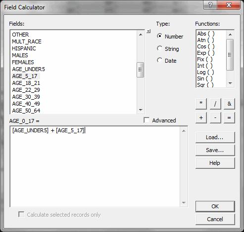
11 Field calculator (numeric) 11


12 Field calculator (text) Concatenate house number and street fields 12
 Very transportable format, very large files Each table record is a row terminated with a line-break character (invisible,")

13 External table file formats for import into ArcGIS Plain ASCII text with comma separated values (.csv) Very transportable format, very large files Each table record is a row terminated with a line-break character (invisible, non-printing value) Has values separated by a delimiter, usually a comma For data values that contain the delimiter, enclose the value in double quotes Sometimes columns get wrong data type on import (use double quotes to force text data type for digits, say for house numbers) 13
14 External table file formats for import to ArcGIS Excel (.xls,.xlsx) Excel 2003, up to 65,000 rows and 256 columns Excel 2007, up to 1,048,576 rows and 16,384 columns dbase database table(.dbf) Legacy format ArcMap truncates field names to 1 st 10 characters dbase IV has maximum of 255 columns Can open dbase file in Excel but cannot save dbase from Excel Microsoft Access database (.mdb) Up to 2GB file size See following for other limits: 14
15 GEOCODES 15
16 Geocodes (2000) Federal Information Processing Standards (FIPS) Developed by the National Institute of Standards and Technology Codes for place names throughout the world countries states/provinces counties metropolitan statistical areas (MSA s) cities places - Indian reservations, airports, and post offices in the US See for additional geocodes. 16
17 Geocodes: hierarchical FIPS codes (political boundaries) Country: US State: 42 (Pennsylvania) County: 003 (Allegheny) Minor Civil Division: (Pittsburgh) Census codes (statistical boundaries) Tract: 1917 Block Group: 003 Block: 005 (US ) Local government cadastral data (legal boundaries) Parcel Block & Lot number 0096-P (1690 Seaton St, Pittsburgh, PA 15226)

18 World and US 18


19 US and state 42 State 42 and county


20 County 003 and municipality Municipality and tract


21 Tract 1917 and block group 003 Block group 003 and block
22 Geocodes (2010) ANSI Codes American National Standards Institute Codes Replace the Federal Information Processing Standards (FIPS) The entities covered include: states and statistically equivalent entities counties and statistically equivalent entities named populated and related location entities (such as, places and county subdivisions) American Indian and Alaska Native areas See 22
23 DATA TABLE JOINS 23
24 Review: table joins Puts two tables together, on the fly, to make one table One-to-one join (e.g., join state attribute data to state shapefile by StateName) One-to-many join (e.g., join code table to feature attribute table to add code description. Many records can use the same code value.) Each table in a join must have key attribute for matching Must have same values and data types for key in both tables 24

25 Example join + = 25
 Text values left align while numeric")
26 Problems with Joins Field types are different (e.g. one is numeric and one is text) Text values left align while numeric values right align 26

27 Solution Create a new field of the same type and use field calculator 27

28 Solution Both tables are same field types 28


29 Problems with Joins Data format varies Must remove dashes 29
30 SPATIAL JOINS 30
31 Spatial Joins Joins using shape (not attribute field) Enables data aggregation (counting or summing points by polygon) Common Spatial Joins Points to Polygons (counts) Polygons to Points (adds text) Points to points (distances) 31
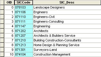
32 Points to polygons How many businesses are in each neighborhood? Start with: Business points Neighborhood polygons 32

33 Points to polygons Right-click neighborhoods > Joins and Relates > Join 33


34 Spatial join result New polygon layer with count of points (number of architects and engineers) 34

35 Spatial join result Show as a choropleth map, with labels, or table Neighborhood Name Count Central Business District 53 Southside Flats 14 Shadyside 9 Bloomfield 8 Lower Lawrenceville 8 North Shore 8 Squirrel Hill South 6 Strip District 6 Point Breeze 4 Squirrel Hill North 4 Garfield 3 South Oakland 3 Friendship 2 North Oakland 2 Carrick 2 Central Lawrenceville 2 East Allegheny 2 Mount Washington 2 East Liberty 1 Central Northside 1 Westwood 1 Banksville 1 Brookline 1 Perry North 1 Highland Park 1 Larimer 1 Allegheny West 1 Middle Hill 1 Bluff 1 Southside Slopes 1 35
36 Points to polygons What neighborhood is a business in? Start with: Business points Neighborhood polygons 36

37 Polygons to points Right-click business points> Joins and Relates > Join 37

38 Spatial join result Point shapefile with neighborhood data on each business 38
39 Points to points How close is the nearest bus stop to a business? Start with: Business points Bus stop points 39
40 Points to points Right-click business points> Joins and Relates > Join 40

41 Result Distance field added to new layer of businesses and stops joined 41
42 SPATIAL DATA FORMATS 42


43 Esri legacy format: Coverage Folder with multiple files Can have points, lines, and/or polygons Has several intermediate data products (topology) to speed up processing (now calculated on the fly) 43


44 Esri legacy format: Shapefile Multiple files, all with the same name but different file extensions No intermediate data products, but has indices to speed data processing Widely used to share spatial data files 44

 Country layer World.")
45 Geodatabases A geodatabase is a container used to hold a collection of datasets (GIS features, tables, raster images, and other objects) Country layer World.gdb Graticule layer 45
46 The architecture of a geodatabase The geodatabase storage model is based on a series of simple yet essential relational database concepts and leverages the strengths of the underlying database management system (DBMS). Simple tables and well-defined attribute types are used to store the schema, rule, base, and spatial attribute data for each geographic dataset. This approach provides a formal model for storing and working with your data. Through this approach, structured query language (SQL) a series of relational functions and operators can be used to create, modify, and query tables and their data elements. 46

47 The architecture of a geodatabase You can see how this works by examining how a feature with polygon geometry is modeled in the geodatabase. A feature class is stored as a table, often referred to as the base or business table. Each row in the table represents one feature. The shape column stores the polygon geometry for each feature. The contents of this table, including the shape when stored as a SQL spatial type, can be accessed through SQL. 47
48 Geodatabase storage in relational databases two primary sets of tables; system tables and dataset tables. At the core of the geodatabase is a standard relational database schema (a series of standard database tables, column types, indexes, and other database objects). The schema is persisted in a collection of geodatabase system tables in the DBMS that defines the integrity and behavior of the geographic information. Well-defined column types are used to store traditional tabular attributes. When the geodatabase is stored within a DBMS, spatial representations, most commonly represented by vectors or rasters, are generally stored using an extended spatial type. 48

49 Dataset table Dataset tables Each dataset in the geodatabase is stored in one or more tables. The dataset tables work with the system tables to manage data. 49
50 Enterprise geodatabases Practically unlimited size and multiple simultaneous users Use enterprise data management systems Store spatial datasets in a number of DBMSs: IBM DB2, Microsoft SQL Server, Oracle, or Postgres 50
51 Personal geodatabase Parallels enterprise geodatabase but on PC Stores datasets in a Microsoft Access.mdb file Limited to 2GB Much overhead in space and extra structure Tempting to apply one s own Access skills, but needs ArcGIS Catalog utility for manipulation 51
52 File geodatabase Esri s replacement for shapefiles Vector and raster map layers Other objects (tables) Stores one or more datasets in a folder of files with.gdb extension Can be up to 1 TB in size Can be used across platforms Can be compressed and encrypted for read-only, secure use 52


53 View geodatabases Cannot identify names in Windows Explorer Must use ArcCatalog 53
54 Non-Esri vector formats Interoperability Ability of different vendors hardware and software to share data Driven by the Internet with standards evolving for open data access (International Organization for Standardization, Open Geospatial Consortium, US Federal Geographic Data Committee) Over 110 vector file formats available in ArcGIS Data Interoperability extension ( 54
55 KML (Keyhole Markup Language) XML schema for Internet-based maps Originally created by Keyhole, Inc. for satellite images and purchased by Google to become Google Maps Provides a set of features (points, lines, polygons, images, text, etc.) with lat/long coordinates plus altitude for 3D viewing KMZ is zipped KML and associated files, needed for upload to Google Maps Portability Can import and export KML/KMZ via ArcToolbox in ArcGIS Can upload to Google maps from your computer 55

56 XY Data Point data table with X and Y attributes Increasingly popular to include X and Y with data Commonly used for GPS data 56
57 CALCULATING GEOMETRY 57

58 Point centroids When displaying or analyzing small polygons it is often better to use point centroids 58
59 Calculate XY fields Add new X and Y fields in the attribute table 59


60 Calculate XY fields Calculate geometry for X field, repeat for Y 60

61 XY field results Results are X and Y values based on map properties (e.g. Long/Lat or XY feet) 61


62 Export table with XY values 62

63 Add XY data table 63

64 Export features XY events should be exported as permanent shapefile or feature class 64


65 Count point centroids Population can be spatially joined to buffer around polluting companies 65
66 Other geometry calculations Area Perimeter Length 66
67 Summary Tables Geocodes Data Table Joins Spatial Joins Spatial Data Formats Geodatabases Calculating Geometry 67
68 Lab and Assignments Lab: Tutorial Lab: Assignment 4.1, 4.2 Due: 10/03/2016 Project outline 68
Key Terms. Attribute join Target table Join table Spatial join
 Key Terms Attribute join Target table Join table Spatial join Lect 10A Building Geodatabase Create a new file geodatabase Map x,y data Convert shape files to geodatabase feature classes Spatial Data Formats
GIS Basics for Urban Studies
 GIS Basics for Urban Studies Date: March 21, 2018 Contacts: Mehdi Aminipouri, Graduate Peer GIS Faciliator, SFU Library (maminipo@sfu.ca) Keshav Mukunda, GIS & Map Librarian Librarian for Geography (kmukunda@sfu.ca)
Lecture 7 Digitizing. Dr. Zhang Spring, 2017
 Lecture 7 Digitizing Dr. Zhang Spring, 2017 Model of the course Using and making maps Navigating GIS maps Map design Working with spatial data Geoprocessing Spatial data infrastructure Digitizing File
Introduction to Geodatabase and Spatial Management in ArcGIS. Craig Gillgrass Esri
 Introduction to Geodatabase and Spatial Management in ArcGIS Craig Gillgrass Esri Session Path The Geodatabase - What is it? - Why use it? - What types are there? - What can I do with it? Query Layers
ENGRG 59910: Introduction to GIS
 ENGRG 59910: Introduction to GIS Lecture 05: GIS and Databases Basics Acknowledgment: Michael Piasecki Where are we now? Basic geographic concepts Introduction to GIS, coordinate system, projection, datum
Chapter 7. A Quick Tour of ArcGIS Pro
 Chapter 7 A Quick Tour of ArcGIS Pro Skills you will learn: This tutorial is intended to get you going using ArcGIS Pro, a new desktop application that is part of ArcGIS Desktop. A separate tutorial gives
Using the Geodatabase
 Using the Geodatabase February 13, 2002 Presented by: John Stroud, ESRI GeoDatabase Geodatabase comes in two flavors Personal mdb format ArcSDE rdbms format ArcGIS is a suite of three products ArcView,
-In windows explorer navigate to your Exercise_4 folder and right-click the DEC_10_SF1_P1.csv file and choose Open With > Notepad.
 BIOL 4460/5460 and GEOL 4460 Introduction to GIS LAB 4 MAKING A THEMATIC MAP This exercise is to show you how to create a map for printing. As you have seen in the lecture, maps can have different purposes
Basic Tasks in ArcGIS 10.3.x
 Basic Tasks in ArcGIS 10.3.x This guide provides instructions for performing a few basic tasks in ArcGIS 10.3.1, such as adding data to a map document, viewing and changing coordinate system information,
Tutorial 1: Finding and Displaying Spatial Data Using ArcGIS
 Tutorial 1: Finding and Displaying Spatial Data Using ArcGIS This tutorial will introduce you to the following: Websites where you may browse to find geospatial information Identifying spatial data, usable
Assimilating GIS-Based Voter Districting Processes in Maricopa County, Arizona
 Assimilating GIS-Based Voter Districting Processes in Maricopa County, Arizona Tim Johnson Geographic Information Systems Manager Maricopa County Recorder/Elections Department Abstract Accurate district
NAACCR Webinar Exercises. May 6, 2010 Kevin Henry Francis Boscoe
 NAACCR Webinar Exercises May 6, 2010 Kevin Henry Francis Boscoe EXERCISE 1 Google Earth and Geocoding Individual Cases Part 1 Introduction to Google Earth 1 Open Google Earth Click Start Programs Google
Chapter 7. A Quick Tour of ArcGIS Desktop (ArcMap)
") Chapter 7 A Quick Tour of ArcGIS Desktop (ArcMap) Skills you will learn: This tutorial is intended to get you going using ArcMap, which is the traditional desktop application that is part of ArcGIS Desktop.
Chapter 7 A Quick Tour of ArcGIS Desktop (ArcMap) Skills you will learn: This tutorial is intended to get you going using ArcMap, which is the traditional desktop application that is part of ArcGIS Desktop.
ArcGIS Online (AGOL) Quick Start Guide Fall 2018
 Quick Start Guide Fall 2018") ArcGIS Online (AGOL) Quick Start Guide Fall 2018 ArcGIS Online (AGOL) is a web mapping tool available to UC Merced faculty, students and staff. The Spatial Analysis and Research Center (SpARC) provides
ArcGIS Online (AGOL) Quick Start Guide Fall 2018 ArcGIS Online (AGOL) is a web mapping tool available to UC Merced faculty, students and staff. The Spatial Analysis and Research Center (SpARC) provides
SAGIS Property Map Viewer Instruction Manual Instructions for using the SAGIS Property Map Viewer. Published December 21, 2018.
 SAGIS Property Map Viewer Instruction Manual www.sagis.org/map Instructions for using the SAGIS Property Map Viewer. Published December 21, 2018. 1 Instructional Videos Click on a link to watch a video
Lab #7: Mapping US Census Data
 Lab #7: Mapping US Census Data Objectives: Access US Census Data via the Web Download census data in excel format Create new variables based on calculations Create key fields for merging with NYC Planning
WOMEN'S INTERAGENCY HIV STUDY SECTION 40: GEOCODING PROTOCOL
 WOMEN'S INTERAGENCY HIV STUDY SECTION 40: GEOCODING PROTOCOL A. BACKGROUND & STUDY PURPOSE This study will investigate how socioeconomic context and health care coverage contribute to health outcomes among
Geocoding Reference USA data in ArcMap 9.3
 Tufts GIS Tip Sheet Geocoding Reference USA data in ArcMap 9.3 Written by Barbara Parmenter Revised 3/1/2011 In this exercise, you will map businesses or services for a town in the Boston metropolitan
1. Open the New American FactFinder using this link:
 Exercises for Mapping and Using US Census Data MIT GIS Services, IAP 2012 More information, including a comparison of tools available through the MIT Libraries, can be found at: http://libraries.mit.edu/guides/types/census/tools-overview.html
Appendix 2: Random Plots Workbook: Unstratified Sample
 Appendix 2: Random Plots Workbook: Unstratified Sample These instructions will help users of all skill levels create a random sample of i-tree Eco plot centers, plot areas, and the associated i-tree Eco-required
INTRODUCTION TO GIS WORKSHOP EXERCISE
 111 Mulford Hall, College of Natural Resources, UC Berkeley (510) 643-4539 INTRODUCTION TO GIS WORKSHOP EXERCISE This exercise is a survey of some GIS and spatial analysis tools for ecological and natural
Welcome to NR402 GIS Applications in Natural Resources. This course consists of 9 lessons, including Power point presentations, demonstrations,
 Welcome to NR402 GIS Applications in Natural Resources. This course consists of 9 lessons, including Power point presentations, demonstrations, readings, and hands on GIS lab exercises. Following the last
Getting Started with ArcGIS Background and Introduction
 Getting Started with ArcGIS Background and Introduction BACKGROUND ON ArcGIS SOFTWARE ArcGIS is a set of tools for collecting, storing, managing, analyzing, and representing geographic information. It
Working with International Census Data in GIS
 Working with International Census Data in GIS Updated February 23, 2015 Table of Contents SETTING UP... 1 DATA SOURCES... 1 TABULAR CENSUS DATA... 2 2001 Tabular Census Data... 5 GEOGRAPHIC DATA... 5 JOINING
Geocoding vs. Add XY Data using Reference USA data in ArcMap
 Geocoding vs. Add XY Data using Reference USA data in ArcMap 10.4.1 Written by Barbara Parmenter. Revised by Carolyn Talmadge 2/27/2017 GETTING BUSINESS DATA FROM REFERENCE USA BY NAICS AND CITY... 2 MODIFY
The Data Journalist Chapter 7 tutorial Geocoding in ArcGIS Desktop
 The Data Journalist Chapter 7 tutorial Geocoding in ArcGIS Desktop Summary: In many cases, online geocoding services are all you will need to convert addresses and other location data into geographic data.
Working with 2000 Census Data in ArcGIS: Using the US Census Bureau Web Site for SF1 and SF3 Data
 Tufts University GIS Tutorial Working with 2000 Census Data in ArcGIS: Using the US Census Bureau Web Site for SF1 and SF3 Data Revised October 14, 2010 Note: we highly recommend Mozilla Firefox for this
LAB 1: Introduction to ArcGIS 8
 LAB 1: Introduction to ArcGIS 8 Outline Introduction Purpose Lab Basics o About the Computers o About the software o Additional information Data ArcGIS Applications o Starting ArcGIS o o o Conclusion To
Exercise 3: Creating a Geodatabase
 Exercise 3: Creating a Geodatabase Introduction: A database (DB) is an organized collection of data, that we can visualize as being a group of tables. An example of a simple database can be seen below:
QGIS Workshop Su Zhang and Laura Gleasner 11/15/2018. QGIS Workshop
 1. Introduction to QGIS QGIS Workshop QGIS is a free and open source Geographic Information System (GIS). QGIS can help users create, edit, visualize, analyze, and publish geospatial information on various
LAB EXERCISE #1 (25pts)
") Grossmont College Introduction to Geographic Information Science Name: Instructors: Judd Curran & Mark Goodman 1 LAB EXERCISE #1 (25pts) ArcGIS Map Projection on the Fly: Working with: U.S. Map illustrating
Grossmont College Introduction to Geographic Information Science Name: Instructors: Judd Curran & Mark Goodman 1 LAB EXERCISE #1 (25pts) ArcGIS Map Projection on the Fly: Working with: U.S. Map illustrating
Downloading Census Data from American Factfinder for use in ArcGIS
 Downloading Census Data from American Factfinder for use in ArcGIS Written by Barbara Parmenter, revised September 24 2013 OBTAINING DATA FROM AMERICAN FACTFINDER (AFF)... 1 PREPARING AMERICAN FACTFINDER
4/7/2009. Model: Abstraction of reality following formal rules e.g. Euclidean space for physical space
 Model: Abstraction of reality following formal rules e.g. Euclidean space for physical space At different levels: mathematical model (Euclidean space) conceptual design model (ER model) data model (design)
Office of Geographic Information Systems
 Office of Geographic Information Systems Print this Page Summer 2011 - Desktop GIS: You Want More Data? By Joe Sapletal, GISP In the Summer 2010 Tech Talk article ArcGIS Services, we addressed connecting
TABLES, ANATOMY OF A TABLE
 week 6 TABLES, ANATOMY OF A TABLE topics of the week Table structure Working with tables Table relationships Cardinality, Joins and Relates Table Jargon What is a Database? What is a Table? What is a Record/Row?
Data Assembly, Part II. GIS Cyberinfrastructure Module Day 4
 Data Assembly, Part II GIS Cyberinfrastructure Module Day 4 Objectives Continuation of effective troubleshooting Create shapefiles for analysis with buffers, union, and dissolve functions Calculate polygon
Introduction to GIS & Mapping: ArcGIS Desktop
 Introduction to GIS & Mapping: ArcGIS Desktop Your task in this exercise is to determine the best place to build a mixed use facility in Hudson County, NJ. In order to revitalize the community and take
Exercise 1: An Overview of ArcMap and ArcCatalog
 Exercise 1: An Overview of ArcMap and ArcCatalog Introduction: ArcGIS is an integrated collection of GIS software products for building a complete GIS. ArcGIS enables users to deploy GIS functionality
Feature Enhancements by Release
 Autodesk Map Feature Enhancements by Release This document highlights the feature enhancements that have occurred with each release of Autodesk Map software from Release 4 (2000i) through the current 2004
ESRI China (Hong Kong) Limited
 Limited") Using Attribute Table Article ID : 100006 Software : ArcGIS Desktop 9.x Platform : Windows 2000, Windows XP Date : September 30, 2005 Background Sometimes the function provided in Attribute Table was overlooked
Using Attribute Table Article ID : 100006 Software : ArcGIS Desktop 9.x Platform : Windows 2000, Windows XP Date : September 30, 2005 Background Sometimes the function provided in Attribute Table was overlooked
Geographical Information Systems Institute. Center for Geographic Analysis, Harvard University. LAB EXERCISE 1: Basic Mapping in ArcMap
 Harvard University Introduction to ArcMap Geographical Information Systems Institute Center for Geographic Analysis, Harvard University LAB EXERCISE 1: Basic Mapping in ArcMap Individual files (lab instructions,
Chapter 9. Attribute joins
 Chapter 9 Spatial Joins 9-1 Copyright McGraw-Hill Education. Permission required for reproduction or display. Attribute joins Recall that Attribute joins: involve combining two attribute tables together
LSGI 521: Principles of GIS. Lecture 5: Spatial Data Management in GIS. Dr. Bo Wu
 Lecture 5: Spatial Data Management in GIS Dr. Bo Wu lsbowu@polyu.edu.hk Department of Land Surveying & Geo-Informatics The Hong Kong Polytechnic University Contents 1. Learning outcomes 2. From files to
Geographical Information Systems Institute. Center for Geographic Analysis, Harvard University
 Geographical Information Systems Institute Center for Geographic Analysis, Harvard University LAB EXERCISE 5: Queries, Joins: Spatial and Non-spatial 1.0 Getting Census data 1. Go to the American Factfinder
Select the Parks within Forest Acres
 Select the Parks within Forest Acres TASKS RESULT 1. Add the county boundary, municipalities and parks (pts.) layers to your map 2. Save your map (.mxd) to your desktop Your map should look something like
The GIS Spatial Data Model
 The GIS Spatial Data Model Introduction: Spatial data are what drive a GIS. Every piece of functionality that makes a GIS separate from another analytical environment is rooted in the spatially explicit
CE 549 Lab 1 - Linking Streamflow Data to a Gauging Station
 CE 549 Lab 1 - Linking Streamflow Data to a Gauging Station Prepared by Venkatesh Merwade Lyles School of Civil Engineering, Purdue University vmerwade@purdue.edu January 2018 Objective The objective of
Topology at the US Census
 Topology at the US Census Daniel Abugov www.acquisinc acquisinc.com dabugov@acquisinc acquisinc.com US Census Requirement for a census is incorporated into the Constitution of the United States* Used for:
ENGRG Introduction to GIS
 ENGRG 59910 Introduction to GIS Michael Piasecki October 5, 2014 Lecture 05: GIS and Databases Basics Where are we now? Basic geographic concepts Introduction to GIS, coordinate system, projection, datum
How to calculate population and jobs within ½ mile radius of site
 How to calculate population and jobs within ½ mile radius of site Caltrans Project P359, Trip Generation Rates for Transportation Impact Analyses of Smart Growth Land Use Projects SECTION PAGE Population
The Oracle Enterprise Geodatabase (EGDB) Charlie Crocker Farallon Geographics, Inc.
 Charlie Crocker Farallon Geographics, Inc.") The Oracle Enterprise Geodatabase (EGDB) Charlie Crocker Farallon Geographics, Inc. www.fargeo.com Norcal URISA Chapter Meeting 2/9/2005 Todays Goals Enterprise geodatabase defined Roles Oracle can play
The Oracle Enterprise Geodatabase (EGDB) Charlie Crocker Farallon Geographics, Inc. www.fargeo.com Norcal URISA Chapter Meeting 2/9/2005 Todays Goals Enterprise geodatabase defined Roles Oracle can play
AGIC 2012 Workshop Leveraging Free RDBMS in ArcGIS
 AGIC 2012 Workshop Leveraging Free RDBMS in ArcGIS Prescott, AZ October 2012 Instructors: Bo Guo, PE, PhD Terry Li Workshop Outline Part I Introduction Why RDBMS Discussion on Obstacles for using RDBMS
Answer the following general questions: 1. What happens when you right click on an icon on your desktop? When you left double click on an icon?
 Name: Date: June 27th, 2011 GIS Boot Camps For Educators Practical: Explore ArcGIS 10 Desktop Tools and functionality Day_1 Lecture 1 Sources: o ArcGIS Desktop help o ESRI website o Getting to Know ArcGIS
Size: Small Medium X Large
 Field Operations Guide By: Elise Fisher Organization: EF Geographic. L.C. Response Time Analysis Brief Explanation: Uses GIS to assess expected response times from each of their existing public safety
Creating a Smaller Data Set from a Larger Data Set Vector Data
 Creating a Smaller Data Set from a Larger Data Set Vector Data Written by Barbara Parmenter, revised by Carolyn Talmadge January 16, 2015 USING THE SELECTION METHOD QUICK METHOD BY CREATING A LAYER FILE...
From Non-Spatial Data to Spatial Data. Geocoding & Georeferencing in ArcGIS
 03-Geocoding & Georeferencing In Arcgis.Doc Page 1 of 10 From Non-Spatial Data to Spatial Data. Geocoding & Georeferencing in ArcGIS Objectives Upon completion of this tutorial, you should be able to perform
New Media in Landscape Architecture: Advanced GIS
 New Media in Landscape Architecture: Advanced GIS - Projections and Transformations - Version 10.2, English ANHALT UNIVERSITY OF APPLIED SCIENCES Hochschule Anhalt Author: Dr. Matthias Pietsch Tutorial-Version:
ArcMap - EXPLORING THE DATABASE Part I. SPATIAL DATA FORMATS Part II
 Week 5 ArcMap - EXPLORING THE DATABASE Part I SPATIAL DATA FORMATS Part II topics of the week Exploring the Database More on the Table of Contents Exploration tools Identify, Find, Measure, Map tips, Hyperlink,
Lab 4. Accessing Secondary Data with CartoDB
 Lab 4 Accessing Secondary Data with CartoDB What You Will Learn How To Access a wide variety of geographic data sources Perform queries on data Digitize your own data Screen-scape from web pages Georeference
Efficient Geocoding with ArcGIS Pro
 What you will need: An ArcGIS Online for organizations account ArcGIS Pro Efficient Geocoding with ArcGIS Pro By Mike Price, Entrada/San Juan, Inc. Public safety organizations rely on reliable, repeatable
PlaceMap. Accommodation. Slide 1
 PlaceMap for Accommodation Slide 1 PlaceMap Using the power of Google Earth to store and display all of your spatial data in a much more dynamic way Google Earth is a free software program that lets you
Module 10 Data-action models
 Introduction Geo-Information Science Practical Manual Module 10 Data-action models 10. INTRODUCTION 10-1 DESIGNING A DATA-ACTION MODEL 10-2 REPETITION EXERCISES 10-6 10. Introduction Until now you have
Explore some of the new functionality in ArcMap 10
 Explore some of the new functionality in ArcMap 10 Scenario In this exercise, imagine you are a GIS analyst working for Old Dominion University. Construction will begin shortly on renovation of the new
Quantitative Mapping Using Census Data
 MAP, DATA & GIS LIBRARY maplib@brocku.ca ArcGIS Pro Census Mapping Quantitative Mapping Using Census Data This tutorial includes all necessary steps to create a thematic map using numeric census tract
Using ESRI data in Autodesk ISD Products
 GI13-3 Using ESRI data in Autodesk ISD Products 1.5 hr. Class 02-Dec-03 3:30pm - 5:00pm Session Description: We will focus on using data in a variety of ESRI formats within the Autodesk GIS product line,
US Geo-Explorer User s Guide. Web:
 US Geo-Explorer User s Guide Web: http://usgeoexplorer.org Updated on October 26, 2016 TABLE OF CONTENTS Introduction... 3 1. System Interface... 5 2. Administrative Unit... 7 2.1 Region Selection... 7
8 Querying and Selecting Data
 8 Querying and Selecting Data In this chapter, we will cover the following recipes: ff ff ff ff ff Constructing proper attribute query syntax Creating feature layers and table views Selecting features
QGIS LAB SERIES GST 103: Data Acquisition and Management Lab 1: Reviewing the Basics of Geospatial Data
 QGIS LAB SERIES GST 103: Data Acquisition and Management Lab 1: Reviewing the Basics of Geospatial Data Objective Explore and Understand Geospatial Data Models and File Formats Document Version: 2014-08-15
Georeferencing. Georeferencing: = linking a layer or dataset with spatial coordinates. Registration: = lining up layers with each other
 Georeferencing How do we make sure all our data layers line up? Georeferencing: = linking a layer or dataset with spatial coordinates Registration: = lining up layers with each other Rectification: The
Esri s ArcGIS Enterprise. Today s Topics. ArcGIS Enterprise. IT4GIS Keith T. Weber, GISP GIS Director ISU GIS Training and Research Center
 Esri s ArcGIS Enterprise IT4GIS Keith T. Weber, GISP GIS Director ISU GIS Training and Research Center Today s Topics Part 1: ArcGIS Enterprise architecture Part 2: Storing and serving data for the enterprise
An Introduction to Data Interoperability
 Esri International User Conference San Diego, California 2012 Technical Workshops July 24/25 An Introduction to Data Interoperability Bruce Harold - Esri Dale Lutz Safe Software Background Why Data Interoperability?
This document explains how to connect to a SQL Server database using ESRI ArcCatalog in order to extract data containing spatial coordinates.
 Arctic Network Arctic Network Data Management Standard Operating Procedure Inventory & Monitoring Program U.S. Department of the Interior Data Management Standard Operating Procedure NPS/ARCN/DMSOP-2009-07
Getting Started with GIS using ArcGIS 10.6 What is GIS? and - Module 1 Creating a map document
 Getting Started with GIS using ArcGIS 10.6 What is GIS? and - Module 1 Creating a map document Marcel Fortin Map & Data Library mdl@library.utoronto.ca 2018 http://mdl.library.utoronto.ca This workshop
Using the SABINS Data Finder
 Using the SABINS Data Finder August 2011 This guide shows users how to use the School Attendance Boundary Information System (SABINS) to access GIS boundary files and data tables for school attendance
Introduction to ArcCatalog
 Introduction to ArcCatalog Introduction To Arc Catalog ArcCatalog is a data- centric GUI tool used for managing spatial data With ArcCatalog you can. Inspect properties and attributes of data Preview and
Data Interoperability Extension Tutorial
 Data Interoperability Extension Tutorial Copyright 1995-2012 Esri All rights reserved. Table of Contents About the Data Interoperability extension tutorial...................... 3 Exercise 1: Using direct-read
Introduction to GIS 2011
 Introduction to GIS 2011 Digital Elevation Models CREATING A TIN SURFACE FROM CONTOUR LINES 1. Start ArcCatalog from either Desktop or Start Menu. 2. In ArcCatalog, create a new folder dem under your c:\introgis_2011
Map Library ArcView Version 1 02/20/03 Page 1 of 12. ArcView GIS
 Map Library ArcView Version 1 02/20/03 Page 1 of 12 1. Introduction 1 ArcView GIS ArcView is the most popular desktop GIS analysis and map presentation software package.. With ArcView GIS you can create
ENGRG Introduction to GIS
 ENGRG 59910 Introduction to GIS Michael Piasecki October 06, 2017 Lecture 05: GIS and Database Basics Where are we now? Basic geographic concepts Introduction to GIS, coordinate system, projection, datum
Data Visualization Techniques with Google Earth
 Data Visualization Techniques with Google Earth E-Learning for the GIS Professional Any Time, Any Place! geospatialtraining.com Course Outline Module 1: Google Earth Pro Fundamentals Module 2: Adding Features
GEOG4017 Geographical Information Systems Lab 3 Data Collection and Integration (I)
") DEPARTMENT OF GEOGRAPHY HONG KONG BAPTIST UNIVERSITY Prof. Q. Zhou GEOG4017 Geographical Information Systems Lab 3 Data Collection and Integration (I) Objectives Before we can use GIS for any analysis
DEPARTMENT OF GEOGRAPHY HONG KONG BAPTIST UNIVERSITY Prof. Q. Zhou GEOG4017 Geographical Information Systems Lab 3 Data Collection and Integration (I) Objectives Before we can use GIS for any analysis
GPS TO GIS EXERCISE (30 PTS)
") GPS TO GIS EXERCISE (30 PTS) This exercise will allow you to demonstrate your cumulative knowledge of using a GPS receiver to collect data with locational information, downloading this data to a desktop
GPS TO GIS EXERCISE (30 PTS) This exercise will allow you to demonstrate your cumulative knowledge of using a GPS receiver to collect data with locational information, downloading this data to a desktop
Lab Assignment 4 Basics of ArcGIS Server. Due Date: 01/19/2012
 Lab Assignment 4 Basics of ArcGIS Server Due Date: 01/19/2012 Overview This lab assignment is designed to help you develop a good understanding about the basics of ArcGIS Server and how it works. You will
Accessing Data Where it Lives
 Accessing Data Where it Lives Session 3A Steve Carr TSI Tyson Haverkort Safe Software Session Description We ll discuss many types of data that can be used in MapInfo Professional such as: Business Data
Mapping Census data in QGIS
 Mapping Census data in QGIS Contents Contents 1. Introduction...3 1.1. Census data...3 1.2. Boundary data...3 1.3. Mapping software...3 2. Obtain your census data...4 Step 1: Geography...4 Step 2: Topics...5
GIS LAB 1. Basic GIS Operations with ArcGIS. Calculating Stream Lengths and Watershed Areas.
 GIS LAB 1 Basic GIS Operations with ArcGIS. Calculating Stream Lengths and Watershed Areas. ArcGIS offers some advantages for novice users. The graphical user interface is similar to many Windows packages
RASTER ANALYSIS S H A W N L. P E N M A N E A R T H D A T A A N A LY S I S C E N T E R U N I V E R S I T Y O F N E W M E X I C O
 RASTER ANALYSIS S H A W N L. P E N M A N E A R T H D A T A A N A LY S I S C E N T E R U N I V E R S I T Y O F N E W M E X I C O TOPICS COVERED Spatial Analyst basics Raster / Vector conversion Raster data
Editing Versioned Geodatabases : An Introduction
 Esri International User Conference San Diego, California Technical Workshops July 24, 2012 Editing Versioned Geodatabases : An Introduction Cheryl Cleghorn Shawn Thorne Assumptions: Basic knowledge of
Converting census data into GIS data
 Converting census data into GIS data For those interested in analyzing Canadian demographics data, census data can be downloaded directly from ODESI or the Canadian Census Analyser. In order to use the
Downloading Census Data from American Factfinder2 for use in ArcGIS
 Downloading Census Data from American Factfinder2 for use in ArcGIS Written by Barbara Parmenter, revised November 18, 2011 OBTAINING DATA FROM AMERICAN FACTFINDER2... 1 PREPARING AMERICAN FACTFINDER DATA
West Virginia Site Locator and West Virginia Street Locator
 West Virginia Site Locator and West Virginia Street Locator West Virginia GIS Technical Center Final Report Prepared August 2009 Revised June 2010 Revised February 2014 West Virginia GIS Technical Center
دورة تدريبية عن تطبيقات برنامج ARC GIS
 دورة تدريبية عن تطبيقات برنامج ARC GIS مايو 2009 دورة تدريبيت عن تطبيقاث برنامج ARC GIS 2009 مايو Table of Contents Introduction... viii Module 1: Introduction to ArcGIS 9 Module Objectives... 1-1 ArcGIS
Exercise 1: Getting to know ArcGIS
 The Scenario You are working for the California Visitor s Commission. You have been asked to prepare a map of California for several dignitaries from out of the country. Your map will need to include enough
Geocoding Address Data
 Preparing for the tutorial Geocoding Address Data First, you need to download the dataset for this exercise from out web server at http://www.library.yale.edu/mapcoll/files/data/geocode_data.zip. Create
Geocoding Reference USA data in ArcMap 10.1
 Geocoding Reference USA data in ArcMap 10.1 Written by Barbara Parmenter, revised 2/21/2014 GETTING BUSINESS DATA FROM REFERENCE USA BY NAICS AND CITY... 2 MODIFY YOUR EXCEL FILE... 5 STARTING ARCMAP...
Data Assembling Topics:
 Topics: 1. GPX to Shape file 2. Data conversion with FME 3. Create a polygon feature 4. Merging /Appending data into a new dataset 5. Reproject data from one coordinate system to another 6. Data clipping
Lab 1: Exploring ArcMap and ArcCatalog In this lab, you will explore the ArcGIS applications ArcCatalog and ArcMap. You will learn how to use
 Lab 1: Exploring ArcMap and ArcCatalog In this lab, you will explore the ArcGIS applications ArcCatalog and ArcMap. You will learn how to use ArcCatalog to find maps and data and how to display maps in
Steve Graves Forensic Geography Lab: Joining Data from Census to GIS. Background
 Steve Graves Forensic Geography Lab: Joining Data from Census to GIS Background Now that you have some experience downloading Census Data from the internet, you must now learn to make it appear on a map
The ArcMap Interface and Using Basic ArcMap Analysis Tools to Create a Map
 The ArcMap Interface and Using Basic ArcMap Analysis Tools to Create a Map *You will need a computer with ESRI ArcGIS Desktop version 9.3 or higher installed* Data Download 1. Save the zipped folder with
Joining Data Tables to SABINS Data
 Joining Data Tables to SABINS Data September 2011 This guide shows users how to join the Attendance Boundary Information System (SABINS) data to Census 2010 tabular data, Common Core of Data (CCD), and