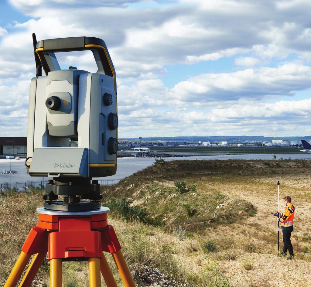
Trimble Total Stations
|
|
|
- Leo Lee
- 6 years ago
- Views:
Transcription
1 Trimble s


2 The Most Advanced Stations. The Ultimate in Efficiency. Trimble C3 Mechanical Trimble C5 Mechanical Trimble S5 Trimble S7 Trimble S9 Trimble SX10 Trimble s: trusted today, designed for tomorrow. For more than a decade, on countless jobs all over the world, Trimble Surveyor s have delivered superior performance, reliability and efficiency. But at Trimble, we are always pushing the envelope, innovating improving. FASTER, EASIER AND MORE PRODUCTIVITY Rely on Trimble s to: Our seven total stations, C3, C5, S5, S7, S9, S9 HP and the SX10; deliver even greater performance and more features than ever. Together, they offer a clear choice between an all in one station for maximum flexibility, an everyday workhorse designed for basic surveying, and an extremely precise model for specialized needs. They re all backed by Trimble s legendary training, service and support. At Trimble, we re constantly focused on making the dayto-day job of surveying faster, easier and more productive. All of our total stations features, functions and software components are designed to boost efficiency in the field and in the office without compromising performance and accuracy. Our EDM technology enables faster in-field measurements with fewer setups while enhancing scanner performance. SurePoint technology reduces aiming errors and costly re-measurements. Our proven field software, Trimble Access, ensures quick data capture in the field. Trimble SureScan technology boosts accuracy, ensures repeatability, and cuts the time necessary to return to the field to collect additional data. It doesn t stop there. Data processing is easier and faster using Trimble Business Center software to integrate all of your geospatial collected data. The conclusion is clear: Trimble s offer the ultimate in efficient, reliable performance. Deliver surveying, imaging and 3D scanning in one powerful solution Capture data faster and more accurately Give the advantage of Trimble VISION technology for video robotic control, scene documentation and measurements Improve accuracy, even over long distances, with Trimble DR Plus and Lightning 3DM Create enhanced 3D models Enable quick data processing with Trimble Business Center office software Locate your equipment in real-time with L2P and manage your equipment with Trimble InSphere Equipment Manager 2 3


3 SX10 Scanning MERGE ALL OF THE GEOSPATIAL SKILLSETS IN YOUR WORKFLOW The Trimble SX10 is the world s first scanning total station that truly merges high-speed 3D scanning, enhanced Trimble VISION imaging and high-accuracy total station measurements in a single instrument. more time creating results. And, since Trimble Access and Trimble Business Center allow operation of the SX10 within familiar survey workflows, there s no need for specialized training, dedicated 3D scanners and personnel. Designed from the ground up to provide maximum accuracy, efficiency and detail, this scanning total station features Trimble s trusted MagDrive and technologies for industry-leading durability and reliability. And the SX10 s powerful new Lightning 3DM has the capabilities you need to handle any survey project. The Trimble SX10 delivers reduced costs and greater versatility to expand to new applications, all with a single investment. Boost productivity, save money and get greater versatility The Trimble SX10 captures rich point cloud data at 26,600 points per second and at a range of up to 600 m. When you get back to the office, the scans register automatically, so you spend less time preparing data and 4 Key features of SX10 : The Trimble SX10 Scanning enables familiar, easy and efficient survey workflows, from the field to the office. Here s how: Combines surveying, imaging and high speed 3D scanning in one revolutionary Scanning The new Lightning 3DM combines high accuracy survey measurements with high speed scanning A foundation of superior 3D scanning At the heart of the Trimble SX10 are fully integrated 3D scanning capabilities. Trimble s Lightning technology allows the Trimble SX10 to measure dense 3D scan data at high speeds while maintaining high precision over the full measurement range. Utilizes Trimble Lightning Scanning technology to scan up to 26,600 points per second captures a full dome scan in as little as 12 minutes Boosts precision, versatility, and efficiency with improved VISION technology. Allows users to manage total station, imaging and 3D scan data efficiently using Trimble Business Center software, making it easy to create results Offers an industry-leading 3D scan range of 600 m while also boasting the smallest spot size in the industry a mere 14 mm at 100 m Provides a horizontal 360 x vertical 300 field of view with scanning and imaging to cover your entire setup You can choose your level of scan density, based on your project. Since registration is automatic, the data you gather drops right into your survey coordinate system. 5


4 SX10 Scanning Boosting precision, versatility and efficiency. ADVANCED VISION TECHNOLOGY THAT HELPS YOU DELIVER SUPERIOR RESULTS The VISION technology onboard the Trimble SX10 makes it easy to direct surveys via live video on the controller. VISION offers varying levels of imaging capabilities and resolutions, so you can collect just the right amount of data to fit your needs, whether you re documenting your site or capturing additional visual detail on your DR observations. Back in the office, Trimble VISION data gives you the option of making additional measurements or delivering 360-degree panoramas. Unparalleled Precision That s the Trimble SX10 The Trimble SX10 Scanning sets a new standard for accuracy, capability and performance. Whether you re performing a typical job or your most challenging survey projects, the SX10 delivers the confidence to do it all and do it well. FAMILIAR TRIMBLE ACCESS AND TRIMBLE BUSINESS CENTER WORKFLOWS Combined with Trimble Access software, the SX10 efficiently and reliably collects the most complete dataset from the field. While in the field, it allows you to: Measure the desired level of detail Integrated scanning workflows Efficient data management In the office, Trimble Business Center seamlessly integrates your project data and provides a virtual surveying environment enabling: Efficient 2D and 3D topographic and façade map creation Earthwork, volumetric and corridor workflows Quickly measure any forgotten or complex field information SX10 Applications Topographic Survey/General Survey Roadway/Corridor Survey Volumetric Survey Infrastructure As-Built Building As-Built Utility Design Survey Power Line Inspection/Clearance Forensics Mine/Quarry Survey Tank Calibration/Inspection Dimensional Control 6 7


5 S9 and S9 HP s Designed for your most-challenging projects. GET THE PERFORMANCE AND ACCURACY YOU NEED FOR SPECIALIZED APPLICATIONS We took our best field technologies, added our highest level of accuracy, and then included all of our specialized engineering features. The result is the Trimble S9 and S9 HP, our premium-performance s designed for your most-challenging projects. Whether it s for tunnels, monitoring, mines, or other difficult applications, rely on the S9 s to combine scanning, imaging and surveying into a single, precise solution. Get the Advanced Solution You Need for Tough Jobs Here are just some of the powerful features and options available for the Trimble S9: 0.5 or 1 accuracy Specialized modules for tunnels, monitoring, or mines for dedicated workflows Optional Trimble SureScan and VISION technology Trimble SurePoint DR HP EDM in the Trimble S9 HP Monitor projects both real time and post-processed to rapidly detect critical structural movements, with Trimble 4D Control software Additional engineering-specific features include Trimble FineLock technology and our Class 3R laser pointer. Trimble FineLock detects targets without interference from surrounding prisms and LongRange FineLock extends that functionality; both provide critical support for high precision applications in close quarters, such as rail alignment, deformation monitoring and tunneling. The Class 3R laser pointer visually mark points at greater range in tunnels or underground mines 8 9


6 S7 Maximize efficiency in the field and in the office. FULLY LOADED FOR MAXIMUM FLEXIBILITY AND PERFORMANCE Imagine needing just one total station on your job site to perform all of the data capture. Imagine just one powerfully equipped total station to handle scanning, imaging and surveying, to create 3D models, to process highly accurate visual site documentation and point clouds, and to do much more. That total station is the Trimble S7. Work Faster with Integrated Scanning and VISION THE ULTIMATE TOTAL STATION The Trimble S7 is a powerful total station with all of the features and tools you need to maximize efficiency in the field and in the office. Other technologies you ll find standard: Enhance your Accuracy with Trimble DR Plus The S7, equipped with DR Plus, delivers enhanced scanner performance with fewer instrument setups. Our DR Plus range measurement feature also dramatically extends the range of Direct Reflex measurement without a prism. Trimble DR Plus makes for quick and easy measurements without compromising accuracy. With Trimble SureScan you collect and process data faster by focusing on collecting the right points, not just more points. SureScan patented technology maintains a user-defined, equal density of points so you won t capture too many points at short distances or too few points at longer distances. The S7 is equipped with Trimble VISION technology. Use it to direct your survey through live video images on the controller. Back in the office, you can use your Trimble VISION data for measurements, or to process 360-degree panoramas and high dynamic range (HDR) images for even clearer deliverables. 10 MagDrive, for exceptional speed and accuracy, reduce wear and tear, and smooth, silent operation FineLock, which detects targets without interference from surrounding prisms, ensuring target lock over long distances, and eliminating errors caused by interference SurePoint, ensures precise pointing and measuring by staying on target through virtually any situation, from windy weather to vibrations Locate2Protect technology and InSphere Equipment Manager Industry-leading field and office software for fast data collection and processing no matter the Trimble instrument INCREASE PRODUCTIVITY WITH TRIMBLE SURESCAN Trimble SureScan technology is a true productivitybooster that saves you time in the field and in the office. It allows you to easily and quickly define a single framed area and set a consistent resolution. This means cleaner, more usable initial data sets, which minimizes the amount of point data and the number of setups required while facilitating office data processing. With SureScan, you can efficiently capture everything you need to create digital terrain models (DTMs) and volume calculations. Plus you can perform topographic measurements faster than traditional surveying methods. Standard scanning grid 11 SureScan scanning grid


7 S5 s The ideal package of exclusive features and proven technology. THE RELIABLE, EFFICIENT, TRUSTED PERFORMER STAY ON TARGET The Trimble S5 offers the ideal package of exclusive Trimble features and proven technology to help you work efficiently and accurately, project after project, year after year. The Trimble target provides versatility to track both active and passive targets. Up to eight active targets can operate simultaneously on the same site with no risk of tracking the wrong target, ensuring accuracy and completeness of work with no loss in productivity due to false target lock. Trimble This is the economical, proven performer that makes your job easier both in the field and in the office. And it s backed by the world-class support including service and training you expect from Trimble. Measure Farther and Faster with the S5 The S5 can include a complete package of Trimble technology to deliver solid, reliable results, on a full range of projects: 12 DR Plus EDM for measuring at greater distances with fewer instrument set-ups, while enhancing scanning performance Your choice of 1, 2, 3, and 5 accuracy MagDrive servo technology, SurePoint, L2P and InSphere Equipment Manager standard 13 MANAGE YOUR EQUIPMENT 24/7 Know where your total stations are 24 hours a day with Trimble L2P technology. See where your equipment is at any given time and get alerts if your instrument leaves a job site or experiences unexpected equipment shock or abuse. Save time managing all of your instruments firmware, software and maintenance requirements with our web based Trimble AllTrak Cloud application. Now you can view usage and keep up to date on all of your total stations in one location.


8 Trimble C-Series C3 Mechanical You work in demanding environments and require reliable and efficient equipment that will work as hard as you do. Trimble C3 Mechanical Trimble C5 Mechanical THE NEW CLASS OF MECHANICAL TOTAL STATIONS MAKING YOUR JOB EASIER, DAY AFTER DAY. The Trimble C-Series mechanical total stations are durable, efficient, highly precise instruments that work as hard as you do. By combining superior optics and autofocus with a rugged, lightweight, user friendly design, the C-Series stations deliver exceptional performance, making field work faster and more productive. With these mechanical total stations, onboard data collection software ensures smooth and efficient workflows. The Trimble C3 mechanical total station is lightweight and compact. So it s easy to store, transport and operate. Setup is simple, too just as you d expect from a Trimble total station. Onboard data collection software ensures smooth, efficient workflows. Wherever Works TakesYou, Take the Trimble C3. The Trimble C3 is lightweight and compact, simplifying storage, transport and setup. Users can work as long as they want without getting tired. And it s tough. It delivers exceptional results, whatever the conditions, wherever you take it. Get a Lot Out of It. Because We Put a Lot Into It. When you work with the Trimble C3, your results are always accurate and true, which ensures greater productivity back in the office. There s no need to return to the field, because you get it right the first time. Key features include: Autofocus that enables precise, quick focus Superior Nikon optics for crisp, bright sightings even in low light conditions PIN code security Full dual-face displays for use with onboard software 1", 2", 3", and 5" accuracies Hot swappable batteries that last all day and let you charge one battery while you re working with the other 14 15


9 C5 Mechanical Trusted and reliable mechanical technology. THE EFFICIENT, ACCURATE WAY TO WORK The Trimble C5 mechanical total station completes the industry s top portfolio with productivity-boosting, timesaving features that make fieldwork easier and faster. The Trimble C5 is tough and reliable with a user-friendly design, limiting user fatigue even as it stands up to the toughest worksite conditions. It quickly captures accurate measurements and virtually eliminates downtime, providing the peace of mind and security that come with L2P-ready location technology. Get the Job Done Right the First Time. Every Time. The Trimble C5 makes fieldwork productive and efficient with the proven fast Trimble setup process and an array of features that include: 16 New autofocus that delivers quick, precise focus on the anticipated distance Superior Nikon optics for crisp, bright sightings even in low light conditions Tough and Easy to Use Wherever you Use it. C5 Key Features The C5 is lightweight and compact, simplifying storage, transport and setup. It s easy to handle, so users can work as long as they want without getting tired. It delivers exceptional results, whatever the conditions, wherever you take it. Work Fast. Stay Productive. Stay Precise. Fully charged, the Trimble C5 batteries have enough power to last all day. And they re hot-swappable, reducing downtime. The new C5 s dual high resolution touch screen displays enable the use of Trimble Access onboard. And the C5 is available in 1, 2, 3, and 5 accuracies. So, whatever the task, it s equipped and ready to deliver the high level of efficiency and productivity the improved workflows you expect from Trimble. 17 Compact, lightweight and rugged system design Autofocus enabling precise and fast focus PIN code security L2P location technology Powerful long range EDM Dual color high resolution touchscreen displays


10 Trimble Access Software Trimble Business Center Software Stronger Software for stronger data. STREAMLINE YOUR EVERYDAY WORKFLOWS Designed to support your everyday work, including topographic surveys, staking, control, and more; Trimble Access offers a familiar, easy-to-use interface delivering increased productivity and saving you money. STREAMLINE THE PROCESS WITH TRIMBLE BUSINESS CENTER Specialized Applications for Increased Productivity Trimble Business Center brings all the data together in a desktop environment. In a single software package you can efficiently work with GNSS, total station, level, scanning, terrestrial and aerial data. Trimble Business Center offers topographic map creation workflow, earthwork operations, corridor operations, bringing the field environment to the office. Trimble Access for General Survey Improve worksite efficiency with functionality in Trimble Access for General Survey: Designed to support your everyday survey workflows One-tap easy-to-use feature coding Powerful COGO routines Graphical staking of points, lines, arcs, and alignments from active maps Integrated Surveying technology combines optical, scanning, and GNSS data plus images in the same job SDK available for personalized development See more at apps.trimbleaccess.com Network and Traverse adjustment workflows for accuracy and confidence Survey CAD environment for end to end deliverables Point cloud tools for visualization, registration, clean up, and automated classification Topo and surface modeling with precise volume calculation and contour creation Data traceability with raw measurement visibility and chronological history GIS integration and compatibility for seamless integration
11 Trimble Configurations Instrument Angular Accuracy EDM Technology EDM Accuracy Servo Trimble Vision Prism Tracking Technology Scanning Technology Speed FineLock Additional Features Trimble C3 1", 2", 3", or 5" DR 2.0 mm + 2 ppm Prism Autofocus Trimble C5 1", 2", 3", or 5" DR 2.0 mm + 2 ppm Prism Tracklight/ Autofocus Trimble S5 1", 2", 3", or 5" DR PLUS Tracklight 1", 2", 3", or 5" DR PLUS Tracklight Trimble S7 1", 2", 3", or 5" DR PLUS Single Camera SureScan 15pps Trimble S9 0.5" DR PLUS Robotic Single Camera SureScan 15pps 0.5" DR PLUS Robotic Long Range FineLock 1" DR PLUS Long Range FineLock Trimble S9 HP 0.5" DR HP 0.5" DR HP Robotic Long Range FineLock Tracklight 0.5" DR HP Robotic Single Camera 1" DR HP Single Camera 1" DR HP Tracklight 1" DR HP Long Range FineLock Instrument Angular Accuracy EDM Technology EDM Accuracy Servo Trimble Vision Prism Tracking Technology Scanning Technology Speed Scanning Range Range Noise Trimble SX10 1" Lightning 3DM 1.0 mm ppm Prism 2.0 mm ppm DR Robotic Multi- Camera Advanced BandScanning 26.6kHz 600 m m m Contact your local Trimble Authorized Distribution Partner for more information NORTH AMERICA Trimble Inc Westmoor Drive Westminster CO USA EUROPE Trimble Germany GmbH Am Prime Parc Raunheim Germany Phone Fax ASIA-PACIFIC Trimble Navigation Singapore Pty Limited 80 Marine Parade Road #22-06, Parkway Parade Singapore Singapore Phone Fax , Trimble Inc. All rights reserved. Trimble, the Globe & Triangle logo and are trademarks of Trimble Inc., registered in the United States and in other countries. 4D Control, Access, FineLock, InSphere, MagDrive,, SurePoint, and VISION are trademarks of Trimble Inc. All other trademarks are the property of their respective owners. PN E (07/17)
Trimble Total Stations
 Trimble Total Stations The Most Advanced Stations. The Ultimate in Efficiency. FASTER, EASIER AND MORE PRODUCTIVITY Our seven total stations, C3, C5, S5, S7, S9, S9 HP and the SX10; deliver even greater
TRIMBLE TOTAL STATIONS: TRUSTED TODAY, DESIGNED FOR TOMORROW.
 GEOSPatial SOLUTIONS Trimble S-SERIES TOTAL Stations TRIMBLE TOTAL STATIONS: TRUSTED TODAY, DESIGNED FOR TOMORROW. For more than a decade, on countless jobs all over the world, Trimble Robotic s have delivered
Trimble 3D Laser Scanning TRANSFORMING THE WAY THE WORLD WORKS
 Trimble 3D Laser Scanning Speed, Precision and Versatility Complete Solutions for Every Challenge CAPTURE AND DELIVER PRECISE DATA. FASTER. For scanning professionals, speed and precision are critical.
Storage Tank Solutions TRANSFORMING THE WAY THE WORLD WORKS
 Storage Tank Solutions Trimble TX8 Scanner: A Revolution in 3D Scanning TRUE PERFORMANCE IN A REAL WORLD The Trimble TX8 laser scanner sets new standards for performance and ease of use in high-speed collection
trimble gnss surveying systems
 trimble gnss surveying systems TRIMBLE GNSS SYSTEMS: SOLVING YOUR CHALLENGES IN THE FIELD INDUSTRY-LEADING GNSS SOLUTIONS DESIGNED WITH THE SURVEYOR IN MIND Backed by a legacy of GNSS technology surveying
TECHNOLOGY SOLUTIONS TRANSFORMING CONSTRUCTION LAYOUT. Trimble Field Link TRANSFORMING THE WAY THE WORLD WORKS
 TECHNOLOGY SOLUTIONS TRANSFORMING CONSTRUCTION LAYOUT Taking full advantage of the Trimble Tablet s processor and multi-touch screen functionality, has been designed to work the way you work. Featuring
TECHNICAL NOTES TRIMBLE SURVEY CONTROLLER SOFTWARE
 TRIMBLE SURVEY CONTROLLER SOFTWARE TECHNICAL NOTES The Trimble Survey Controller software is the data collection solution that will make your survey work faster, easier, and more productive than ever before.
The Trimble 3D Scanning Solution: Designed by Surveyors for Surveyors
 The Trimble 3D Scanning Solution: Designed by Surveyors for Surveyors TRIMBLE 3D SCANNING Designed by surveyors for surveyors, the Trimble 3D scanning solution follows the surveying workflow you re familiar
trimble gnss surveying systems
 trimble gnss surveying systems TRIMBLE GNSS SYSTEMS: SOLVING YOUR CHALLENGES IN THE FIELD INDUSTRY-LEADING GNSS SOLUTIONS DESIGNED WITH THE SURVEYOR IN MIND Backed by a legacy of GNSS technology surveying
technical notes trimble business center software
 technical notes trimble business center software A POWERFUL SURVEY DATA OFFICE SOFTWARE SUITE DESIGNED FOR TODAY'S FAST-PACED SURVEYING OFFICE, TRIMBLE BUSINESS CENTER SOFTWARE UNLOCKS THE POTENTIAL OF
Geospatial GNSS Systems TRANSFORMING THE WAY THE WORLD WORKS
 Geospatial GNSS Systems GNSS Solutions Designed with the Surveyor in Mind POWERFUL TECHNOLOGY YOU CAN DEPEND ON NO MATTER WHAT THE CHALLENGE Whether you are climbing over rough terrain to collect topographic
Trimble Field Solutions in Surveying
 Trimble Field Solutions in Surveying Trimble Survey Controllers and Field Software A total approach to managing fieldwork. RELEASE THE FULL POTENTIAL OF YOUR SURVEYING GEAR AND YOUR BUSINESS Trimble controllers
technical notes trimble realworks software
 technical notes trimble realworks software A POWERFUL 3D LASER SCANNING OFFICE SOFTWARE SUITE Designed for today s multifaceted scanning professional, Trimble RealWorks is a powerful office software that
Realworks Software. A Powerful 3D Laser Scanning Office Software Suite
 TECHNICAL NOTES Realworks Software A Powerful 3D Laser Scanning Office Software Suite Trimble RealWorks is a powerful office software that imports rich data from your 3D laser scanning instrument and transforms
TECHNICAL NOTES SURVEY PRO WITH TSX
 SURVEY PRO WITH TSX TECHNICAL NOTES Survey Pro software from TDS is the data collection solution of choice for most North American surveyors 1. And with the addition of the Trimble TSX (Trimble Systems
Trimble Realworks Software
 TECHNICAL NOTES Trimble Realworks Software A Powerful 3D Laser Scanning Office Software Suite DESIGNED FOR TODAY S MULTIFACETED SCANNING PROFESSIONAL, TRIMBLE REALWORKS IS A POWERFUL OFFICE SOFTWARE THAT
RealWorks Software. A Powerful 3D Laser Scanning Office Software Suite
 TECHNICAL NOTES RealWorks Software A Powerful 3D Laser Scanning Office Software Suite Trimble RealWorks is a powerful office software that imports rich data from your 3D laser scanning instrument and transforms
trimble unmanned aircraft systems
 trimble unmanned aircraft systems FOR SURVEYING and MAPPING TRIMBLE UAS AERIAL IMAGING solution: INDUSTRY-LEADING UAS MAPPING SOLUTIONS FOR ALL YOUR APPLICATION NEEDS Trimble prides itself on being a leader
Trimble MX2 mobile mapping
 Trimble MX2 mobile mapping user applications Point clouds within your reach The Trimble MX2 is a vehicle-mounted spatial imaging system which combines high resolution laser scanning and panoramic cameras
technical notes Trimble survey controller field software
 Trimble survey controller field software technical notes For more than a decade, Trimble Survey Controller field software has provided land surveyors with a complete GNSS and optical data-collection solution
Trimble Positioning for Automotive Applications
 Trimble Positioning for Automotive Applications Trimble at a Glance Core Markets Agriculture Construction Building Construction Geospatial Transportation Emerging Markets Automotive Rail A MARKET LEADER
TRIMBLE GEOMATICS OFFICE TECHNICAL NOTES
 The Trimble Geomatics Office software is an important part of Trimble s total surveying solutions. Never has the collection, processing, and management of survey data been so easy. Surveyors and engineers
TRIMBLE MONITORING SOLUTIONS MEASURING CHANGE
 TRIMBLE MONITORING SOLUTIONS MEASURING CHANGE THE BUSINESS OF MONITORING With decades of experience around the world, Trimble s flexible and scalable monitoring systems meet a wide range of project requirements.
GLOBAL SERVICES TRAINING SUPPORT REPAIR SERVICES
 GLOBAL SERVICES TRAINING SUPPORT REPAIR SERVICES GLOBAL SERVICES OVERVIEW Trimble s Global Services Division has Training, Support, and Repair Service programs dedicated to lowering our customers operational
TRIMBLE S6 ACCESSORIES BUNDLES GUIDE
 TRIMBLE S6 ACCESSORIES BUNDLES GUIDE TRIMBLE S6 SERVO ACCESSORY KIT RECOMMENDATIONS SLSU-S2001 Servo Target Kit containing: 571126110 Prism: Reflector tiltable, large 63.5 mm (2.5 in) 571126311 Signal
technical notes Trimble survey Manager Software
 Trimble survey Manager Software technical notes Powerful field and office software for the acquisition, processing, and display of precise real-time surveys. Never has the integration of survey data from
Total Station Series 3000
 Total Station Series 3000 OPTIMIZED FOR PERFORMANCE Advanced Technology Integrated Surveying Maximum Versatility Direct Reflex Capability Optimized for Performance 3600 DR REFLECTORLESS 3300 DR REFLECTORLESS
ADDING MICROSENSORS AND TRIMBLE SUREPOINT TECHNOLOGY TO SURVEY ROVERS FOR ENHANCED ACCURACY AND PRODUCTIVITY
 BEYOND GNSS ADDING MICROSENSORS AND TRIMBLE SUREPOINT TECHNOLOGY TO SURVEY ROVERS FOR ENHANCED ACCURACY AND PRODUCTIVITY WHITE PAPER BEYOND GNSS: ADDING MICROSENSORS AND TRIMBLE SUREPOINT TECHNOLOGY TO
HV601/HV602 for General Construction
 HV601/HV602 for General Construction CONTROL YOU CAN RELY ON Accurate Versatile Fast Easy to Use Precision Leveling and Aligning Maximum Versatility The Spectra Precision Laser HV601 and HV602 from Trimble
Adam Hammet & Anthony McClaren. Getting to know the Trimble SX10 Scanning Total Station - Inside and Out ISV Regional Conference 2017: Moama, NSW
 Adam Hammet & Anthony McClaren Getting to know the Trimble SX10 Scanning Total Station - Inside and Out ISV Regional Conference 2017: Moama, NSW Contents Difference between scanner and a Total station
Trimble. LM80 Layout Manager A BLUEPRINT FOR SUCCESSFUL LAYOUT. Easy to Use Increased Productivity Minimum Errors and Rework Maximum Reliability
 Trimble LM80 Layout Manager A BLUEPRINT FOR SUCCESSFUL LAYOUT Easy to Use Increased Productivity Minimum Errors and Rework Maximum Reliability In a Class of its Own The Trimble LM80 is a revolutionary
2/19/2018. Who are we? Who am I? What is Scanning? How does scanning work? How does scanning work? Scanning for Today s Surveyors
 2/19/2018 Who are we? Scanning for Today s Surveyors Survey, GIS, and Construction dealer Founded in 1988 Employee Owned Headquartered in Bismarck, ND States covered: ND, SD, MN, MT, WY, CO, UT, ID, WA,
3D Laser Scanning Technology. Fast, Safe, Accurate. Rugged hardware and powerful software combined with streamlined survey workflow
 3D Laser Scanning Technology Fast, Safe, Accurate Rugged hardware and powerful software combined with streamlined survey workflow Maptek specialises in the research, development and application of 3D laser
Trimble S6. General. The Trimble S6 Total Station provides the power and flexibility required by today\'s surveying professionals.
 Trimble S6 General Product Description Product Brochure The Trimble S6 Total Station provides the power and flexibility required by today\'s surveying professionals. /upload/165-868-5836.pdf Demonstration
Trimble Productivity: Finish Faster with Fewer Machines. GCS600 Grade Control System
 Trimble Productivity: Finish Faster with Fewer Machines GCS600 Grade Control System for Excavators Flexible, Affordable and Easy to Use Productivity and Payback in One Package: Looking for a flexible,
Overview of the Trimble TX5 Laser Scanner
 Overview of the Trimble TX5 Laser Scanner Trimble TX5 Revolutionary and versatile scanning solution Compact / Lightweight Efficient Economical Ease of Use Small and Compact Smallest and most compact 3D
Trimble Business Center Software, v3.30
 Trimble Business Center Software, v3.30 We are pleased to announce a new version of the Trimble Business Center software, version 3.30. This new version includes over 30 new features and enhancements increasing
TechnicalNotes. Trimble Geomatics Office Software
 TechnicalNotes Trimble Geomatics Office Software AT LAST A SINGLE SOFTWARE PACKAGE TO HANDLE ALL OF YOUR SURVEY DATA The Trimble Geomatics Office software is a key component in the Trimble Toolbox of Integrated
Trimble Site EASY-TO-USE RELIABLE ACCURATE
 Trimble Site Positioning Systems ACCURATE RELIABLE EASY-TO-USE more tools for more jobs Estimators Bid Team Site Surveyor Data Manager Site Engineer/Grade Checker Site Foreman/Supervisor Project Manager
Trimble Engineering & Construction Group, 5475 Kellenburger Road, Dayton, OH , USA
 Trimble VISION Ken Joyce Martin Koehler Michael Vogel Trimble Engineering and Construction Group Westminster, Colorado, USA April 2012 Trimble Engineering & Construction Group, 5475 Kellenburger Road,
Leica High-Definition Surveying Systems. Leica HDS3000. The Industry Standard for High-Definition Surveying
 Leica High-Definition Surveying Systems Leica HDS3000 The Industry Standard for High-Definition Surveying HDS High-Definition Surveying TM : Laser Scanning Redefined High-Definition Surveying, or HDS,
The Leica HDS Family. The Right Tool for the Job HDS3000 HDS2500 HDS4500. Cyclone & CloudWorx. Press the QuickScan button to define the field-of-view.
 HDS2500 High accuracy scanner, ideal for fixed or raised installations when leveled tripod mounting is not practical, or areas with less stringent field-of-view requirements. The Leica HDS Family Time-of-flight
TRIMBLE FIELD POSITIONING SOLUTIONS FOR GENERAL CONTRACTORS
 TRIMBLE FIELD POSITIONING SOLUTIONS FOR GENERAL CONTRACTORS Construction Layout for General Contractors SETTING THE STANDARD construction layout solution for the general contractor. With the increasing
The Most Comprehensive Solution for Indoor Mapping Applications
 The Most Comprehensive Solution for Indoor Mapping Applications TRIMBLE INDOOR MOBILE MAPPING SOLUTION TRIMBLE INDOOR MOBILE MAPPING SOLUTION (TIMMS): HIGH EFFICIENCY, MAXIMUM FLEXIBILITY, ALL-IN-ONE PACKAGE
TOTAL STATION THE POWER OF ONE. One surveyor. One system. 1One company.
 TOTAL STATION 5600 THE POWER OF ONE. One surveyor. One system. 1One company. capabili THE POWER OF ONE. CONTROL TOPO DR REFLECTORLESS As a 21st-century surveyor, you face challenges undreamed of before.
Trimble. S6 Total Station. Demonstration Guide
 Trimble S6 Total Station Demonstration Guide Version 1.00 Revision A Part Number 022543-106 January 2005 Contact Information Trimble Geomatics and Engineering Division 5475 Kellenburger Road Dayton, Ohio
Trimble Access and Trimble SX10 Scanning Total Station Guide
 Trimble Optical and Field Software October 2016 Trimble Access and Trimble SX10 Scanning Total Station Guide Trimble SX10 Scanning Total Station Innovative True merging of high-speed scanning, enhanced
Leica ScanStation C10 The All-in-One Laser Scanner for Any Application
 The All-in-One Laser Scanner for Any Application Versatility, Productivity, Value Many organizations interested in laser scanning to diversify and/or improve current business have been waiting for a scanner
TRIMBLE GEDO SYSTEMS PRECISION, EFFICIENCY, AND SAFETY IN RAIL MEASUREMENT
 TRIMBLE GEDO SYSTEMS PRECISION, EFFICIENCY, AND SAFETY IN RAIL MEASUREMENT FLEXIBLE SOLUTIONS FOR RAILWAY MEASUREMENT RAILWAYS ARE ESSENTIAL COMPONENTS OF THE GLOBAL ECONOMY AND INFRASTRUCTURE. THROUGHOUT
Trimble Railways GEDO Trolley System
 Trimble Railways GEDO Trolley System Trimble Railways GEDO Trolley System In the railway industry, projects require different applications of measurement techniques. The Trimble Railways GEDO Trolley System
Grade Control. GRADE CONTROL SYSTEMS Topcon. MOTOR GRADER 3D-GPS+, mmgps Plug-and-Play. HYDRAULIC EXCAVATOR X63 3D-GPS+ Plug-and-Play
 GRADE CONTROL SYSTEMS Topcon Grade Control CRAWLER DOZER 3D-MC 2 Plug-and-Play HYDRAULIC EXCAVATOR X63 3D-GPS+ Plug-and-Play MOTOR GRADER 3D-GPS+, mmgps Plug-and-Play PHOTOS MAY INCLUDE OPTIONAL EQUIPMENT
Trimble Survey Controller. Release Notes
 Trimble Survey Controller Release Notes Version 10.5 Revision A September 2002 Corporate Office Trimble Navigation Limited Engineering and Construction Division 5475 Kellenburger Road Dayton, Ohio 45424-1099
2D CONSTRUCTION SOLUTIONS
 2D CONSTRUCTION SOLUTIONS 2D CONSTRUCTION SOLUTIONS Keep your projects on time and under budget. We have the leadingedge hardware, software, and mobile solutions you need to increase efficiency, improve
TechnicalNotes. Geodimeter Control Unit
 TechnicalNotes Geodimeter Control Unit THE ADVANCED TOTAL FIELD SOLUTION FROM TRIMBLE Today s land surveyors demand high productivity, total flexibility, and top quality from their instruments. The Trimble
2D CONSTRUCTION SOLUTIONS
 2D CONSTRUCTION SOLUTIONS 2D CONSTRUCTION SOLUTIONS Keep your projects on time and under budget. We have the leadingedge hardware, software, and mobile solutions you need to increase efficiency, improve
Comprehensive Seismic Survey Design And Data Processing. Trimble GPSeismic TRANSFORMING THE WAY THE WORLD WORKS
 Comprehensive Seismic Survey Design And Data Processing Trimble GPSeismic GPSeismic GPSeismic has been continuously developed for over twenty-five years by engineers whose combined professional backgrounds
AGRICULTURE CORRECTION SERVICES
 AGRICULTURE CORRECTION SERVICES NEW! CENterPoint RTX The new Trimble CenterPoint RTX Correction Service delivers GNSS enabled, repeatable 1.5-inch (4 cm) corrections to your receiver anywhere in the world.
tax incentives expire December 31, 2008! HURRY! Special pricing, financing plans and product specials inside PRECISION PRODUCTS
 Join the Team & Be Rewarded PRODUCTS valid through December 31, 2008 YEAR-END SPECIALS & FINANCING OPTIONS HURRY! Special pricing, financing plans and tax incentives expire December 31, 2008! product specials
BEFORE YOU BUY: SEVEN CRITICAL QUESTIONS TO ASK ABOUT LASER SCANNERS. Robert Gardiner
 BEFORE YOU BUY: SEVEN CRITICAL QUESTIONS TO ASK ABOUT LASER SCANNERS Robert Gardiner Table of Contents Introduction... 3 Horizontal and Vertical Angular Accuracies... 4 Movement Tracking... 6 Range Limitations...
2/9/2016. Session Agenda: Implementing new Geospatial Technologies for more efficient data capture
 Implementing new Geospatial Technologies for more efficient data capture Jay Haskamp Applied Geospatial Engineer Steve Richter VP Sales Session Agenda: Today s changing technologies and what lies ahead
DATA COLLECTORS FC-100 / FC-2000
 FC-100 / FC-2000 DATA COLLECTORS Topcon Field Computers; FC-100 and FC-2000 Compact, ultra bright, sealed and sturdy field computers. The demands of modern field data collection and control have changed
GeoMax TPS family. Works when you do.
 Works when you do GeoMax TPS family GeoMax has a complete TPS portfolio to fulfill the needs of all users. Ensure ultimate reliability with GeoMax TPS systems even in challenging environments. Providing
TechnicalNotes. Trimble Total Control Software
 TechnicalNotes Trimble Total Control Software POWERFUL GEODETIC CONTROL FOR ALL SURVEY PROJECTS A survey is only as good as its control elements. Trimble Total Control software puts you in total control
3D Scanning Technology in the Transportation Infrastructure: Case Studies from Around the Globe
 John Whitehead Director of Sales, Asia-Pacific JANUARY 2018 3D Scanning Technology in the Transportation Infrastructure: Case Studies from Around the Globe Overview What does 3D Scanning have to do with
X-PAD Ultimate. The Ultimate solution in the field. Works when you do
 Works when you do X-PAD Ultimate The Ultimate solution in the field X-PAD Ultimate is a tailored, flexible, modular, ideal, customised software for high end topographic tasks, such as measure, stake-out,
Leica FlexLine TS09plus Full Precision at High Performance
 Leica FlexLine TS09plus Full Precision at High Performance The First Plus: Original Leica Geosystems Quality For most, quality is relative. Not so at Leica Geosystems. To ensure our instruments meet the
Product Bulletin WORKING WITH POINT CLOUDS IN TRIMBLE BUSINESS CENTER
 Product Bulletin GEOSPATIAL NOVEMBER 2017 WORKING WITH POINT CLOUDS IN TRIMBLE BUSINESS CENTER This bulletin explains the differences between working with s in Trimble Business Center and Trimble RealWorks
Trimble Survey Controller. Release Notes
 Trimble Survey Controller Release Notes Version 7.70 Revision A January 2001 Corporate Office Trimble Navigation Limited Technical Publications Group 645 North Mary Avenue Post Office Box 3642 Sunnyvale,
connecting your construction site
 TRIMBLE: Connecting Your Construction SitE connecting your construction site The Ultimate Data Management System Business Center Heavy Construction Edition (HCE) from Trimble is the only office software
technical notes Trimble business CenTer software trimble BuSineSS Center your Complete office Solution
 Trimble business CenTer software technical notes trimble BuSineSS Center your Complete office Solution designed for today's fast-paced surveying office, trimble Business Center unlocks the potential of
Geospatial Engineering Problems & Solutions Associated With NDP Roads, Tunnelling & Civil Engineering Projects Use of HDS Leica Laser Scanners
 Geospatial Engineering Problems & Solutions Associated With NDP Roads, Tunnelling & Civil Engineering Projects Use of HDS Leica Laser Scanners Laser Scanning Laser Scanning is a method of collecting large
Trimble GEDO Systems
 Trimble GEDO Systems Flexible Solutions for Railway Measurement Railways are essential components of the global economy and infrastructure. Throughout their life cycle, rail operators demand efficient
TRIMBLE GPS SEARCH TECHNOLOGY FOR THE PROFESSIONAL SURVEYOR
 TRIMBLE GPS SEARCH TECHNOLOGY FOR THE PROFESSIONAL SURVEYOR BY TIM LEMMON AND CHRIS VAN DER LOO, TRIMBLE APPLICATIONS SPECIALISTS, WESTMINSTER, COLORADO, U.S.A. ABSTRACT The Global Positioning System (GPS)
NEW PERSPECTIVE SEPTEMBER 2017
 VOLUME 7 ISSUE 6 SEPTEMBER 2017 NEW PERSPECTIVE 18 26 38 POLARIS SHOWS THE WAY The terrestrial laser scanning market continues to evolve, providing today s practitioner with an abundance of options LITTLE
3D Laser Scanner. Fast, Portable, Accurate. Long range laser scanner Modular design configured to suit your survey needs
 3D Laser Scanner Fast, Portable, Accurate Long range laser scanner Modular design configured to suit your survey needs Introducing the Maptek I-Site 8820 laser scanner The Maptek I-Site 8820 laser scanner
OMNII RT15 - THE BEAUTIFULLY RUGGED HANDHELD FOR FIELD WORKERS
 OMNII RT15 - THE BEAUTIFULLY RUGGED HANDHELD FOR FIELD WORKERS The new Omnii RT15 is the result of requests for a sleeker, customer-facing device that s rugged enough to handle unforgiving field environments.
Leica System 1200 Software Integrated Software for GPS1200 and TPS1200
 Leica System 1200 Software Integrated Software for GPS1200 and TPS1200 Leica System 1200 Software System 1200 software includes SmartWorx the onboard TPS, GPS and RX1250 software and the Leica Geo Office
Pave the Way to Better Profits. Trimble. Paving Solutions TRANSFORMING THE WAY THE WORLD WORKS
 Pave the Way to Better Profits Trimble Paving Solutions TRANSFORMING THE WAY THE WORLD WORKS Solutions for the Complete Paving Job Site Productive, integrated and innovative solutions to keep you on track
TRIMBLE BUSINESS CENTER
 TRIMBLE BUSINESS CENTER Release Notes Version 3.40 (64-bit) Geospatial Division, 10368 Westmoor Drive, Westminster, CO 80021, USA 2014, Trimble Navigation Limited. All rights reserved. Trimble, the Globe
Measuring on Machine Tools Probing Systems and Software
 Measuring on Machine Tools Probing Systems and Software Your Solution Partner in Machine Tool Probing m&h designs and manufactures precision made, highquality, dependable probe systems for use in machine
TRIMBLE ASPHALT PAVING SOLUTIONS
 TRIMBLE ASPHALT PAVING SOLUTIONS Mill Fill better from the ground up Today s road projects require contractors to work faster, with better accuracy, and with tighter control on costs. For the paving contractor,
White Paper. Inside Trimble TX6 and TX8 Deep Dive into Lightning Technology. Prepared by Gregg Jackson and Gregory Lepere ABSTRACT
 White Paper Inside Trimble TX6 and TX8 Deep Dive into Lightning Technology Prepared by Gregg Jackson and Gregory Lepere ABSTRACT With the introduction of next generation Trimble Lightning technology, users
RELEASE NOTES TRIMBLE REALWORKS SOFTWARE VERSION System requirements New Features and Changes
 RELEASE NOTES TRIMBLE REALWORKS SOFTWARE VERSION 9.0.1.313 System requirements New Features and Changes Trimble Navigation Ltd, 10368 Westmoor Drive, Westminster, CO 80021, USA 2014, Trimble Navigation
Leica Zeno 20 More than GPS
 Leica Zeno 20 More than GPS TECHNOLOGIES Leica Zeno 20 does so much more The Leica Zeno 20 is much more than just GPS it is a fusion of great technologies. Powerful and easy, it s the ultimate geospatial
Optical Network Management System. Remote Testing, Network Monitoring, and Service Provisioning Solution for High-Quality Network Performance
 Optical Network Management System Remote Testing, Network Monitoring, and Service Provisioning Solution for High-Quality Network Performance JDSU Enabling Broadband and Optical Innovation Improving the
WE ENABLE CONTENT-CREATORS TO CAPTURE & TELL THEIR STORIES.
 WE ENABLE CONTENT-CREATORS TO CAPTURE & TELL THEIR STORIES. Table of Contents Pg Product Thunderbolt USB-C USB FireWire esata RAID Enabled ev Series Enterprise-class 1 HDD 6 NEW G-SPEED Shuttle with Thunderbolt
TRIMBLE PAVING SOLUTIONS MILL FILL
 TRIMBLE PAVING SOLUTIONS MILL FILL better from the ground up Today s road projects require contractors to work faster, with better accuracy, and with tighter control on costs. For the paving contractor,
A New Way to Control Mobile LiDAR Data
 A New Way to Control Mobile LiDAR Data Survey control has always been a critically important issue when conducting mobile LiDAR surveys. While the accuracies currently being achieved with the most capable
The sixth fruition of over 10 years endeavor
 The sixth fruition of over 10 years endeavor Bluebird is the first provider of industrial touch mobile computers in the world. Over the past 10 years, we have presented these fruition. The latest models
Trimble Productivity: Finish Faster with Fewer Machines. TRIMBLE GCS900 GRADE CONTROL SYSTEMS
 Trimble Productivity: Finish Faster with Fewer Machines. TRIMBLE GCS900 GRADE CONTROL SYSTEMS TAKE ThE GUESSWORK OUT OF EARThWORKS. ONLY FROM ThE LEADER. TRIMbLE. The Connected Construction Site An interesting
GeoMax Total Station Zoom30 Series
 GeoMax Total Station Zoom30 Series GeoMax About Us GeoMax is an internationally active company developing, manufacturing and distributing quality construction and surveying instruments. We provide a comprehensive
GCS900 GRADE CONTROL SySTEmS LK Bu RADE G FINISH
 GCS900 GRADE CONTROL Systems BulK Grade take the guesswork out of earthworks Trimble sets the standard for construction technology by developing highly productive, integrated and innovative solutions for
OPEN-PIT MINE SCANNING IN INDONESIA, HYDRONAV SERVICES OF SINGAPORE
 OPEN-PIT MINE SCANNING IN INDONESIA, HYDRONAV SERVICES OF SINGAPORE TRIMBLE 3D SCANNING CASE STUDY BY PAUL BIDDISCOMBE Nusa Tenggara is the Indonesian name for the more than 500 islands east of Bali, running
DPM PRODUCTS AT-A-GLANCE. A new level of performance, affordability and total cost of ownership for DPM applications DPM SOLUTIONS
 DPM PRODUCTS AT-A-GLANCE A new level of performance, affordability and total cost of ownership for DPM applications DPM SOLUTIONS THE NEXT GENERATION OF DIRECT PART MARK (DPM) SCANNING DEVICES Patented
REASONS. to choose a Fluke Infrared Camera
 REASONS to choose a Fluke Infrared Camera 1Superior image quality Fluke maximizes the performance of every pixel throughout our entire infrared camera portfolio with detector resolutions ranging from 1024x768
A New Epic to a Legacy of Breakthrough Technology
 SOKKIA CLASSIC A New Epic to a Legacy of Breakthrough Technology Far from home, in the most demanding worksites, you need to rely on toughness and accuracy to pull you through. In the middle of the desert,
Merging Geospatial Technologies to Improve the Bottom Line. John Whitehead Trimble Navigation Limited
 Merging Geospatial Technologies to Improve the Bottom Line John Whitehead Trimble Navigation Limited Trimble: Data Collection to Decision Making Today s Survey Professional Today s Customer Requirements
3D Laser Scanning Technology. Rugged hardware and powerful software combined with streamlined survey workflow
 3D Laser Scanning Technology Rugged hardware and powerful software combined with streamlined survey workflow I-Site XR3 laser scanner The Maptek I-Site XR3 laser scanner represents the latest laser imaging
OMNII XT10. Modular Performance That s Built Around You. Introducing the all-new Omnii XT10
 Modular Performance That s Built Around You Introducing the all-new Omnii XT10 We understand that you need products that adapt and change to meet your business needs. The new Omnii platform delivers an
Leica FlexLine TS06plus Top precision meets high efficiency
 Leica FlexLine TS06plus Top precision meets high efficiency The First Plus: Original Leica Geosystems quality For most, quality is relative. Not so at Leica Geosystems. To ensure our instruments meet the