TRIMBLE PAVING SOLUTIONS MILL FILL
|
|
|
- Cordelia Harriet Owen
- 5 years ago
- Views:
Transcription


1 TRIMBLE PAVING SOLUTIONS MILL FILL

2 better from the ground up Today s road projects require contractors to work faster, with better accuracy, and with tighter control on costs. For the paving contractor, that means no unplanned downtime, minimal material usage, and zero re-work. Trimble paving solutions are designed for today s competitive environment. Whether you are building a new road or resurfacing an old one, Trimble solutions will help you build a better surface, reduce material use, and significantly improve your productivity. The more you use Trimble paving solutions, the more productive and profitable your paving operation will be. Resurfacing an Old Road: Topo Design & Take-off Mill Site Positioning Systems Business Center HCE GCS900 Grade Control System Building a New Road: Topo Design & Take-off Grade & Compact Site Positioning Systems Business Center HCE GCS900 Grade Control System
3 Trimble offers road building solutions from concept to completion; from the initial design to the last pass of the asphalt compactor. Using Business Center Heavy Construction Edition and Trimble 3D technology, you can create a better foundation for the asphalt, whether it is on soil or existing asphalt layers. The best built roads begin with a quality subsurface before the paver ever starts. For new roads, start by creating a quality 3D design using Business Center HCE software powered by Trimble. Then Trimble 3D grade control systems on your motor grader and soil compactor will help you achieve a more uniformly compacted surface that s right on grade. For resurfacing an old road, use Trimble 3D grade control on your milling machine to smooth out undulations and imperfections in the original surface. Supervise & Check Pave Compact Site Positioning Systems PCS400 Paving Control System CCSFlex Supervise & Check OR Pave OR Compact Site Positioning Systems PCS900 Paving Control System CCS900 Compaction Control System


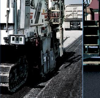
4 better milling for better paving 3d milling with Trimble gcs900 Milling to a fixed depth often satisfies the specification for a resurfacing project, but it leaves any improvements to road smoothness to the paver. With Trimble GCS900 Grade Control System on your milling machine you can mill at variable depth and slope, eliminating undulations and preparing a smoother sub-surface for new asphalt. When used in conjunction with a paver equipped with PCS400 or PCS900, the end result is a significantly smoother road surface using less material and finished in less time. mill smarter Using GCS900 on your milling machine provides several benefits: Smoother base mill out the existing undulations, creating a smoother surface for paving Shorter lane shutdowns trucks can run more efficiently unhindered by stringline and stakes Reduced machine wear by only milling to the depth required, the machine will burn less fuel and experience less teeth wear Less material to remove fewer trucks and cost required to remove waste material Less asphalt usage mill off the minimum depth and use less asphalt for the final surface Prism: Patented Trimble active tracking technology guarantees total station lock to the on-machine target and ensures millimeter control of the milling machine drum. Cb460 Control box: The Trimble CB460 Control Box indicates the position of the drum versus the 3D design or pre-defined vertical offset. Result after fixed depth milling of a road with longitudinal waves result after paving: lower smoothness bonus + higher asphalt usage = less profit, worse road Result after 3D milling of a road with longitudinal waves result after paving: maximized smoothness bonus + minimized asphalt usage = more profit, better road


.")
5 accurate milling. no stringlines Accurate milling begins with a quality 3D design model created in Business Center HCE. The 3D design is loaded onto the control box and displayed to the machine operator showing areas that are on, above, or below ideal grade. Comparing the actual drum position and slope with the digital design, the system automatically guides the milling drum to cut the ideal depth and slope without stringlines or manual adjustments. With GCS900 on your mill, you easily handle transitions, super-elevated curves, variable drainage slopes and longitudinal waves. And you can do it all without re-work. 3D Design Model created in Business Center - HCE Guidance to grade shown to the operator in plan, profile, and cross section view Trimble sps930 universal ToTal station: The industry-leading Trimble SPS930 Universal Total Station locks onto and tracks the MT900 active target mounted on the milling machine. Trimble active tracking technology guarantees lock to the target, ignoring passing vehicles, strobes, and other reflective objects. By measuring the angle and distance to the target, the SPS930 can very accurately drive the mill drum to cut to the digital 3D design within feet. (3-6 millimeters). THe sps930 is ideal For milling because: It offers the best accuracy on the market every millimeter saved reduces your milling and paving costs substantially. It is flexible and reliable you can work on sites where there is an obstructed view of the sky (overpasses, trees, tunnels). It has a 45 degree tracking angle you can set it up very close to the mill in narrow corridors or at a lower elevation than the mill in the drainage area between divided highways. It maximizes your return on investment other survey and machine control work can be done with the same instrument.


6 a more uniform surface 2d Paving with Trimble PCs400 The Trimble PCS400 system is ideal for projects that require meeting a thickness specification. When milling is done to design using Trimble 3D technology, Trimble 2D paving technology can easily handle the task of paving a fixed thickness. The Trimble PCS400 Paving Control System uses sonic tracers, a 30-foot averaging beam, and averaging technology to ensure highly accurate referencing off a surface, stringline or cross-slope. This makes the PCS400 an excellent, lower cost option for roads that have been graded or milled using Trimble Grade Control Systems. many benefits From one system Using the Trimble PCS400 system can help you: Lay the finished surface with accuracy to 0.01 feet (3 millimeters) Minimize use of expensive material... pave within a tighter tolerance and get closer to the minimal asphalt thickness specification Reduce labor costs by controlling the screed with one operator Eliminate operator mistakes with the easy-to-use display interface Achieve maximum smoothness and rideabiity Finish on time Cb440 Control box: The CB440 Control Box displays the measured and target values of the cross slope and mat thickness simultaneously. st200 sonic Tracer: The PCS400 Averaging Beam uses three evenly spaced ST200 Sonic Tracers to average out uneven reference surfaces.

7 referencing off a surface Each side of the paver is typically equipped with one sonic tracer or with three sonic tracers mounted on an averaging beam. These sonic tracers send multiple sonic signals to reference off the existing surface and calculate an average elevation for paving a smooth surface. referencing off stringline The ST200 sonic tracer can be configured to use stringline as a reference line to control the paver. In this mode the sonic tracer will measure any lateral movement of the machine relative e to the stringline. When the sonic tracer's center is moving away from the stringline, the control box warns you and provides correction guidance. referencing off THe slope sensor The PCS400 system can also use the Trimble AS200 Angle Sensor to reference the desired cross-slope of the road. Designed specifically for asphalt pavers, the sensor rarely needs recalibration and paves cross slopes of up to 0.5% accurately and consistently. Trimble Result PCs400 averaging beam and sonic TraCers Three ST200 Sonic Tracers mounted on the averaging beam ignore irregularities such as grates, and stones that could otherwise decrease accuracy. The beam measures a full 30 feet (9.1 meters) in length as required by some governmental agencies and swings back behind the paver to reference both the adjoining surface and freshly laid mat. Trimble Cb440 ConTrol box The PCS400 system features a large display and an easy-to-understand layout for controlling cross slope and material thickness. The optional split screen view on the CB440 Control Box allows you to control and monitor the left and right side of the screed with just one operator. You can even view the measured and target values of the cross slope and mat thickness simultaneously.


8 3d precision paving without stringlines 3d Paving with Trimble PCs900 The Trimble PCS900 Paving Control System adds the accuracy and flexibility of 3D technology to your paving operations, giving you the flexibility of operating in either 2D or 3D mode, depending on project needs. In addition to PCS400, which paves at a fixed depth and slope, the PCS900 allows you to also pave with variable depth and slope based on the 3D design. The PCS900 upgrade consists of a Trimble SPS930 Universal Total Station, an MT900 active target, and a CB460 display running the PCS900 on-board software. If you already have a Trimble GCS900 Grade Control System on your grading or milling machine, you can leverage your investment by simply re-deploying the same display, machine target, and total station for your paver. avoid THe Problems of stringline Stringless 3D technology resolves the problems inherent to stringline because: It eliminates time consuming and costly manual setup and possible human errors It eliminates the possibility that stringlines can be moved or damaged It improves truck productivity with less travelling and maneuvering around the stringlines Prism: Patented Trimble active tracking technology guarantees total station lock to the on-machine target and millimeter control of the screed. Cb460 Control box: The CB460 3D Control Box offers a 7 inch (18 centimeter) graphical display and adjustable light settings for day or night paving.


9 PreCision Paving WiTH less material The PCS900 system regularly achieves asphalt mat accuracies of feet (3-6 millimeters), making it ideal for projects such as airports, large commercial surfaces and highways. Accurate 3D control of the screed allows you to: Take out high and low areas early in the process with the less expensive first layer materials Increase road smoothness using less asphalt than with traditional paving methods Lay complex designs such as transitions, super-elevated curves and frequently changing cross slopes Achieve accuracy and smoothness specifications, which can mean bonus income good designs make good surfaces Good digital designs are the foundation to starting your paving project, but you need not be an advanced CAD professional to get the job done. Data preparation and management for asphalt paving projects is easy with Business Center HCE. Using Business Center HCE, you can create 3D design models and automatically generate uncompacted surface designs for the Trimble PCS900 3D paving system. The uncompacted surface designs guide the paver to automatically lay more material above low areas and less material in high areas, anticipating and eliminating longitudinal waves that can occur after asphalt compaction. Cb440 Control box: The CB440 Control Box displays the measured and target values of the cross slope and mat thickness simultaneously. sps930 universal Total station: PCS900 leverages the same Trimble Universal Total Station as the GCS900 milling system to provide feet (3-6 millimeter) accuracy for laying asphalt.


10 target compaction in fewer passes 3d Compaction with Trimble CCs900 The asphalt compactor is the last machine to pass over your paving project, and mistakes during this phase can be very costly to fix. You can significantly reduce the need for re-work by installing the Trimble CCS900 Compaction Control System on your asphalt compactors. The CCS900 system eliminates much of the guess work from asphalt compaction and helps achieve more consistent compaction to target design density. You will also be able to roll a more efficient pattern, increase productivity, and save fuel. map it and get it right Pass count mapping in the CCS900 system allows you to monitor the number of passes over an area and adjust your effort to avoid over or under-compaction. Using the roof-mounted GNSS receiver or machine target, the system calculates the exact position of the machine and displays a color map indicating the current number of passes and where you have overlaps or gaps. When installed with two optional IS310 Infrared Sensors, CCS900 maps the surface temperature of the mat and pinpoints exactly where you need to be for ideal compaction timing. Cb460 or Cb450 Control box: The Control Box graphically maps pass counts and surface temperature readings with high and low temperature warnings to indicate potential issues in real-time.


11 reporting and documentation In-field reporting and an in-cab printer allow on-site supervisors and quality managers to monitor compaction operations and correct possible issues immediately. Compaction data logs can be wirelessly transferred from the machine to the office for analysis using the web-based VisionLink fleet, asset and productivity management solution from Trimble. Operator view of pass count mapping Operator view of temperature mapping ms972 gnss smart antenna: The Trimble MS972 Smart GNSS Antenna measures the position of the compactor using a base station or satellite delivered correction sources such as SBAS. A printed in-field report showing pass count coverage upgradeable and PorTable across machines The Trimble CCS900 Compaction Control System is fully upgradeable and can be installed on any asphalt compactor. The wiring harness and brackets are permanently installed for optimal fit and integration with the machine body, while the more costly positioning sensor, control box, and radio from the CCS900 system can be ported between compactors to maximize utilization of the investment. These components can also be used on a wide range of paving and earthmoving machines to increase utilization even more. You can use a common platform and components across your entire fleet, while at the same time knowing you chose the right solution for your asphalt compactor. is310 infrared Temperature sensors: IS310 Infrared Temperature Sensors are installed on the front and rear drum to measure surface temperature of the mat in the direction of operation. Trimble Cb450 and Cb460 ConTrol box The 7 inch (18 cm) CB460 Control Box is the premium display for the CCS900 system. The CB450 Control Box offers a smaller 4.3 inch (10 cm) display and is priced for maximum return on investment.


12 affordable. easy to use Pass count mapping with CCsFlex The Trimble CCSFlex Compaction Control System is an easy-to-use and affordable compaction control system to help you increase your compaction efficiency in the most economical way. Unlike CCS900 which requires a more permanent installation on the machine, the CCSFlex system is completely portable between compactors and requires no welding or drilling onto the machine. Designed specifically for compactors, CCSFlex cannot be installed on other earthmoving and paving machines. get started QuiCKlY Straight out of the case, you can run the CCSFlex system without a GPS base station and without creating 3D designs. The highly intuitive CCSFlex software guides you to the exact number of passes required for the job and provides instant feedback on pass count and compaction quality. You simply can t go wrong. Cb450 Control box: The in-cab control box provides visual guidance regarding pass count and compaction by painting a map in real time, showing on a color scale the number of passes over each spot.


13 PorTable system in a Case The CCSFlex in a case system is easy to install by the contractor in a couple of hours. This easy portability makes the system an ideal solution if you employ rented compactors or you want to move the system between compactors in your fleet. It can be installed on any asphalt compactor with open or enclosed cab. ms972 gnss smart antenna: The MS972 provides sub meter accurate positioning of the compactor. Position information is used to display a pass count coverage map in real time on the in-cab control box. system Cables and mounts: The system cables are used to connect the GPS receiver to the in-cab control box. Installation is easy, requiring no drilling or welding. The Trimble CCSFlex system comes standard as a pass count system with an MS972 GNSS Smart Antenna, CB450 Control Box, moveable mounting brackets, and system cables. add-on options Add-on options allow you to increase the functionality and accuracy of the system, as the need arises. System accuracy can be increased to 1 cm (0.03 foot) by adding options to the GNSS receiver. is310 infrared sensor: Two IS310 Infrared Sensors can be added to the CCSFlex system to enable temperature mapping. Trimble Cb450 ConTrol box The CCSFlex system uses the same CB450 Control Box as the CCS900 Compaction Control System.


14 dependability when you need it dependable TeCHnologY. dependable support. Reliability is especially important in paving systems, because you lose money any time the process stops. Trimble components are built to withstand the heat, steam, tamping and vibration that are the norm on milling machines, pavers, and compactors. And while system durability prevents downtime, Trimble s extensive SITECH dealer network ensures that training and support are always close at hand. SITECH is the leading distribution network for the most reliable, rugged and complete portfolio of construction technology systems available to the heavy and highway contractor. The experienced construction professionals at your SITECH dealership will advise you on the right technology for your job and provide you with local customer service, personalized training and technical support. With the addition of Trimble site-wide solutions to your heavy and highway projects, you re in a stronger, more competitive position. You ll experience new levels of productivity that will help you win the bid and be profitable, project after project.


 vertical Trimble location rtk accuracy is 8 mm (0.03 ft) Horizontal and 100mm (0.33 ft) vertical satellite based augmentation system (sbas) accuracy is approximately 0.5m (1.")
15 recommended Technology for Your application milling asphalt Paving asphalt Compaction 3D Grade & Slope application description examples gcs900 PCs400 Road jobs with an accurate reference surface or curb Road jobs with an accurate reference surface or curb and a stringent smoothness spec Asphalt paving without stringlines or accurate reference surface but with stringent elevation, cross slope and/or smoothness specs Asphalt paving with frequent cross slope changes Grade & Slope PCs400 with averaging beam 3D PCs900 Passcount / Temperature Mapping CCsFlex / CCs900 with gnss Roads, parking lots Optional Recommended Recommended Highways, airports Optional Recommended Recommended Airports, roller compacted concrete paving, base material paving, asphaltic base for concrete roads Highway exits and curves, parking lots, sports surfaces As-Built Cut-Fill Mapping CCs900 with universal Total station Recommended Recommended Recommended Optional Recommended Recommended Recommended system accuracies For each TeCHnologY employed vertical accuracy Horizontal accuracy Trimble Total station accuracy at 100 m is 3mm (0.01 ft) Horizontal and 1mm (0.003 ft) vertical Trimble Precision gnss accuracy is 8mm (0.03 ft) Horizontal and 15 mm (0.05 ft) vertical Trimble location rtk accuracy is 8 mm (0.03 ft) Horizontal and 100mm (0.33 ft) vertical satellite based augmentation system (sbas) accuracy is approximately 0.5m (1.7 ft) in both the vertical and Horizontal
16 Trimble: The Construction Technology Standard Trimble provides the tools and support to let you integrate planning, design, site positioning, machine control and asset management information throughout the construction life cycle for more efficient operations and higher profits. Visit your SITECH technology dealer today to learn how easy it is to utilize technology that makes significant improvements in project workflow, dramatically increases your production, improves your accuracy and lowers your operating costs. Your Trimble Heavy Civil Construction Provider NORTH AMERICA Trimble Heavy Civil Construction Division Westmoor Drive, Suite #100 Westminster, Colorado USA (Toll Free) Phone Fax EUROPE Trimble Germany GmbH Am Prime Parc Raunheim GERMANY Phone Fax AFRICA & MIDDLE EAST Trimble Export Middle-East P.O. Box LOB / 1607 JAFZ View Dubai UAE Phone Fax ASIA-PACIFIC Trimble Navigation Singapore PTE Ltd. 80 Marine Parade Road, #22-06 Parkway Parade Singapore, SINGAPORE Phone Fax CHINA Trimble Beijing 20F, Central Tower, China Overseas Plaza, No.8 Yard, Guang Hua Dong Li, Chaoyang District, Beijing, PRC CHINA Phone Fax , Trimble Navigation Limited. All rights reserved. Trimble, SITECH, and the Globe & Triangle logo are trademarks of Trimble Navigation Limited registered in the United States and in other countries. CCSFlex, Connected Site, MultiTrack and VisionLink are trademarks of Trimble Navigation LImited. Microsoft is a registered trademark of the Microsoft Corporation in the United States and/or other countries. All other trademarks are the property of their respective owners (12/11)
TRIMBLE ASPHALT PAVING SOLUTIONS
 TRIMBLE ASPHALT PAVING SOLUTIONS Mill Fill better from the ground up Today s road projects require contractors to work faster, with better accuracy, and with tighter control on costs. For the paving contractor,
GCS900 GRADE CONTROL SySTEmS LK Bu RADE G FINISH
 GCS900 GRADE CONTROL Systems BulK Grade take the guesswork out of earthworks Trimble sets the standard for construction technology by developing highly productive, integrated and innovative solutions for
Trimble Productivity: Finish Faster with Fewer Machines. TRIMBLE GCS900 GRADE CONTROL SYSTEMS
 Trimble Productivity: Finish Faster with Fewer Machines. TRIMBLE GCS900 GRADE CONTROL SYSTEMS TAKE ThE GUESSWORK OUT OF EARThWORKS. ONLY FROM ThE LEADER. TRIMbLE. The Connected Construction Site An interesting
Trimble Site EASY-TO-USE RELIABLE ACCURATE
 Trimble Site Positioning Systems ACCURATE RELIABLE EASY-TO-USE more tools for more jobs Estimators Bid Team Site Surveyor Data Manager Site Engineer/Grade Checker Site Foreman/Supervisor Project Manager
Advanced Use of Automatic Grade Controls. Jeroen Snoeck Segment Manager Paving Trimble Navigation Ltd.
 Advanced Use of Automatic Grade Controls Jeroen Snoeck Segment Manager Paving Trimble Navigation Ltd. Contents Industry trends driving technology in Heavy & Highway Construction Traditional Grade Control
Pave the Way to Better Profits. Trimble. Paving Solutions TRANSFORMING THE WAY THE WORLD WORKS
 Pave the Way to Better Profits Trimble Paving Solutions TRANSFORMING THE WAY THE WORLD WORKS Solutions for the Complete Paving Job Site Productive, integrated and innovative solutions to keep you on track
connecting your construction site
 TRIMBLE: Connecting Your Construction SitE connecting your construction site The Ultimate Data Management System Business Center Heavy Construction Edition (HCE) from Trimble is the only office software
Trimble Productivity: Finish Faster with Fewer Machines. GCS600 Grade Control System
 Trimble Productivity: Finish Faster with Fewer Machines GCS600 Grade Control System for Excavators Flexible, Affordable and Easy to Use Productivity and Payback in One Package: Looking for a flexible,
Trimble Railways GEDO Trolley System
 Trimble Railways GEDO Trolley System Trimble Railways GEDO Trolley System In the railway industry, projects require different applications of measurement techniques. The Trimble Railways GEDO Trolley System
Kevin Garcia and Brian Girouard February Machine Control Technology in Milling and Paving
 Kevin Garcia and Brian Girouard February 2017 Machine Control Technology in Milling and Paving Brian E Girouard, Milling Paving Compaction Specialist Civil Engineering & Construction Americas Trimble Navigation
TECHNOLOGY SOLUTIONS TRANSFORMING CONSTRUCTION LAYOUT. Trimble Field Link TRANSFORMING THE WAY THE WORLD WORKS
 TECHNOLOGY SOLUTIONS TRANSFORMING CONSTRUCTION LAYOUT Taking full advantage of the Trimble Tablet s processor and multi-touch screen functionality, has been designed to work the way you work. Featuring
3D Milling. Tom Abell
 3D Milling Tom Abell Trimble & 3D Milling as Part of the Resurfacing Process Design Measure Resurfacing From initial survey to finish surface Mill Compact Pave Content Data acquisition Creating data models
Trimble 2D Paving Control System for Pavers
 Trimble 2D Paving for Pavers PCS400 2D Paving Key Advantages The only large 2D paving display is easy to learn operate Split screen option allows one operator to easily monitor both sides of the screed
HV601/HV602 for General Construction
 HV601/HV602 for General Construction CONTROL YOU CAN RELY ON Accurate Versatile Fast Easy to Use Precision Leveling and Aligning Maximum Versatility The Spectra Precision Laser HV601 and HV602 from Trimble
FEBRUARY Trimble PCS900 3D Milling & 3D Paving
 FEBRUARY 2018 Trimble PCS900 3D Milling & 3D Paving Presenter Kevin Ackley Sitech Michigan Why use 3D Milling and 3D Paving? To build better pavement Structures!!! Sample Engineering Specifications 2D
Trimble. LM80 Layout Manager A BLUEPRINT FOR SUCCESSFUL LAYOUT. Easy to Use Increased Productivity Minimum Errors and Rework Maximum Reliability
 Trimble LM80 Layout Manager A BLUEPRINT FOR SUCCESSFUL LAYOUT Easy to Use Increased Productivity Minimum Errors and Rework Maximum Reliability In a Class of its Own The Trimble LM80 is a revolutionary
3D System. 2D & 3D Systems. Compact Attachments
 3D System 2D & 3D Systems 1 2D System 2D System Systems work off a single plain Flat Single slope Dual Slope Bobcat laser system is 2D 2 Sonic 3 3D System 3D System Works off elevation coordinates setup
2D CONSTRUCTION SOLUTIONS
 2D CONSTRUCTION SOLUTIONS 2D CONSTRUCTION SOLUTIONS Keep your projects on time and under budget. We have the leadingedge hardware, software, and mobile solutions you need to increase efficiency, improve
TRIMBLE TOTAL STATIONS: TRUSTED TODAY, DESIGNED FOR TOMORROW.
 GEOSPatial SOLUTIONS Trimble S-SERIES TOTAL Stations TRIMBLE TOTAL STATIONS: TRUSTED TODAY, DESIGNED FOR TOMORROW. For more than a decade, on countless jobs all over the world, Trimble Robotic s have delivered
2D CONSTRUCTION SOLUTIONS
 2D CONSTRUCTION SOLUTIONS 2D CONSTRUCTION SOLUTIONS Keep your projects on time and under budget. We have the leadingedge hardware, software, and mobile solutions you need to increase efficiency, improve
GLOBAL SERVICES TRAINING SUPPORT REPAIR SERVICES
 GLOBAL SERVICES TRAINING SUPPORT REPAIR SERVICES GLOBAL SERVICES OVERVIEW Trimble s Global Services Division has Training, Support, and Repair Service programs dedicated to lowering our customers operational
trimble gnss surveying systems
 trimble gnss surveying systems TRIMBLE GNSS SYSTEMS: SOLVING YOUR CHALLENGES IN THE FIELD INDUSTRY-LEADING GNSS SOLUTIONS DESIGNED WITH THE SURVEYOR IN MIND Backed by a legacy of GNSS technology surveying
OCTOBER OTEC Session 75 Stringless 3D Paving
 OCTOBER 03 2018 OTEC Session 75 Stringless 3D Paving Introductions Brian E Girouard, Trimble Inc Sales Engineer Paving Specialist Manager brian_girouard@trimble.com Brad Cunningham, SITECH Ohio SITECH
Trimble Positioning for Automotive Applications
 Trimble Positioning for Automotive Applications Trimble at a Glance Core Markets Agriculture Construction Building Construction Geospatial Transportation Emerging Markets Automotive Rail A MARKET LEADER
Storage Tank Solutions TRANSFORMING THE WAY THE WORLD WORKS
 Storage Tank Solutions Trimble TX8 Scanner: A Revolution in 3D Scanning TRUE PERFORMANCE IN A REAL WORLD The Trimble TX8 laser scanner sets new standards for performance and ease of use in high-speed collection
The Trimble 3D Scanning Solution: Designed by Surveyors for Surveyors
 The Trimble 3D Scanning Solution: Designed by Surveyors for Surveyors TRIMBLE 3D SCANNING Designed by surveyors for surveyors, the Trimble 3D scanning solution follows the surveying workflow you re familiar
Grade Control. GRADE CONTROL SYSTEMS Topcon. MOTOR GRADER 3D-GPS+, mmgps Plug-and-Play. HYDRAULIC EXCAVATOR X63 3D-GPS+ Plug-and-Play
 GRADE CONTROL SYSTEMS Topcon Grade Control CRAWLER DOZER 3D-MC 2 Plug-and-Play HYDRAULIC EXCAVATOR X63 3D-GPS+ Plug-and-Play MOTOR GRADER 3D-GPS+, mmgps Plug-and-Play PHOTOS MAY INCLUDE OPTIONAL EQUIPMENT
TRIMBLE WESTMINSTER BUILDING PROJECT / 2013
 TRIMBLE WESTMINSTER BUILDING PROJECT - 2012 / 2013 OVERVIEW Outgrowing its current office facility in Westminster, Colorado, Trimble decided to build a larger campus across the street from their current
Trimble MX2 mobile mapping
 Trimble MX2 mobile mapping user applications Point clouds within your reach The Trimble MX2 is a vehicle-mounted spatial imaging system which combines high resolution laser scanning and panoramic cameras
Leica icon grade Intelligent grading systems NEW. igd4 SP System. i n telligent COnstruction
 Leica icon grade Intelligent grading systems NEW igd4 SP System i n telligent COnstruction Leica icon grade Maximize productivity, speed & flexibility The Leica icon grade solutions can revolutionize your
TECHNICAL NOTES TRIMBLE SURVEY CONTROLLER SOFTWARE
 TRIMBLE SURVEY CONTROLLER SOFTWARE TECHNICAL NOTES The Trimble Survey Controller software is the data collection solution that will make your survey work faster, easier, and more productive than ever before.
TECHNICAL NOTES SURVEY PRO WITH TSX
 SURVEY PRO WITH TSX TECHNICAL NOTES Survey Pro software from TDS is the data collection solution of choice for most North American surveyors 1. And with the addition of the Trimble TSX (Trimble Systems
Trimble Grade Control Systems GCS900 2D for Motor Graders
 GCS900 2D for Motor Graders Trimble offers the heavy and highway contractor the broadest range of Grade Control Systems in the industry. From 2D laser or sonic based to 3D GNSS or Total Station based,
Trimble Grade Control Systems GCS900 2D for Motor Graders
 GCS900 2D for Motor Trimble offers the heavy and highway contractor the broadest range of Grade Control in the industry. From 2D laser or sonic based to 3D GNSS or Total Station based, Trimble systems
AGRICULTURE CORRECTION SERVICES
 AGRICULTURE CORRECTION SERVICES NEW! CENterPoint RTX The new Trimble CenterPoint RTX Correction Service delivers GNSS enabled, repeatable 1.5-inch (4 cm) corrections to your receiver anywhere in the world.
Geospatial GNSS Systems TRANSFORMING THE WAY THE WORLD WORKS
 Geospatial GNSS Systems GNSS Solutions Designed with the Surveyor in Mind POWERFUL TECHNOLOGY YOU CAN DEPEND ON NO MATTER WHAT THE CHALLENGE Whether you are climbing over rough terrain to collect topographic
Presentation Overview
 Stringless Concrete Paving STRINGLESS CONCRETE PAVING ACPA BUS TOUR AUGUST 5, 2015 Presentation Overview 1) Manufactures 2) Components needed for Stringless Paving 3) Conventional Methods VS Stringless
ACAF Paving Electronics (Today and Future) TOPCON POSITIONING SYSTEMS / LENGEMANN CORPORATION TRIMBLE NAVIGATION / SITECH NORTH, CENTRAL FLORIDA
 TOPCON POSITIONING SYSTEMS / LENGEMANN CORPORATION TRIMBLE NAVIGATION / SITECH NORTH, CENTRAL FLORIDA") ACAF 2016 ROGER CROFT GREG HASTY TOPCON POSITIONING SYSTEMS / LENGEMANN CORPORATION TRIMBLE NAVIGATION / SITECH NORTH, CENTRAL FLORIDA 2D & 3D Machine Control ROGER CROFT TOPCON POSITIONING SYSTEMS / LENGEMANN
ACAF 2016 ROGER CROFT GREG HASTY TOPCON POSITIONING SYSTEMS / LENGEMANN CORPORATION TRIMBLE NAVIGATION / SITECH NORTH, CENTRAL FLORIDA 2D & 3D Machine Control ROGER CROFT TOPCON POSITIONING SYSTEMS / LENGEMANN
Trimble Grade Control Systems GCS900 2D for Excavators
 GCS900 2D for Excavators Trimble offers the heavy and highway contractor the broadest range of Grade Control in the industry. From 2D depth, slope, and elevation-based to 3D GNSS or Total Station-based,
TRIMBLE FIELD POSITIONING SOLUTIONS FOR GENERAL CONTRACTORS
 TRIMBLE FIELD POSITIONING SOLUTIONS FOR GENERAL CONTRACTORS Construction Layout for General Contractors SETTING THE STANDARD construction layout solution for the general contractor. With the increasing
trimble gnss surveying systems
 trimble gnss surveying systems TRIMBLE GNSS SYSTEMS: SOLVING YOUR CHALLENGES IN THE FIELD INDUSTRY-LEADING GNSS SOLUTIONS DESIGNED WITH THE SURVEYOR IN MIND Backed by a legacy of GNSS technology surveying
Automatic 3D control system for SP 15 / SP 15 i / SP 25 / SP 25 i. AutoPilot 2.0
 Automatic 3D control system for SP 15 / SP 15 i / SP 25 / SP 25 i. AutoPilot 2.0 02 03 AutoPilot 2.0 the innovative 3D control system The use of standard 3D machine control systems for the production of
Trimble Grade Control Systems GCS900 2D for Excavators
 GCS900 2D for Excavators Trimble offers the heavy and highway contractor the broadest range of Grade Control Systems in the industry. From 2D depth, slope, and elevation based to 3D GNSS or Total Station
SITECH INTERMOUNTAIN YOUR CONSTRUCTION TECHNOLOGY PROVIDER
 SITECH INTERMOUNTAIN YOUR CONSTRUCTION TECHNOLOGY PROVIDER SITECH Intermountain is established in Utah and Nevada as well as in several adjacent counties in Wyoming, Arizona and California and joins the
TRIMBLE GEOMATICS OFFICE TECHNICAL NOTES
 The Trimble Geomatics Office software is an important part of Trimble s total surveying solutions. Never has the collection, processing, and management of survey data been so easy. Surveyors and engineers
USER GUIDE. Trimble SCS900 software
 USER GUIDE Trimble SCS900 software Version 3.5.1 Revision A April 2016 1 Corporate Office Trimble Navigation Limited 935 Stewart Drive Sunnyvale, CA 94085 USA www.trimble.com Heavy Civil Construction Division
Trimble Field Solutions in Surveying
 Trimble Field Solutions in Surveying Trimble Survey Controllers and Field Software A total approach to managing fieldwork. RELEASE THE FULL POTENTIAL OF YOUR SURVEYING GEAR AND YOUR BUSINESS Trimble controllers
technical notes trimble realworks software
 technical notes trimble realworks software A POWERFUL 3D LASER SCANNING OFFICE SOFTWARE SUITE Designed for today s multifaceted scanning professional, Trimble RealWorks is a powerful office software that
AccuGrade Compaction GPS Mapping & Measurement System. Global Paving
 AccuGrade Compaction GPS Mapping & Measurement System The AccuGrade Connected Work Site AccuGrade Rugged, reliable machine control and guidance solution. AccuGrade Ready Option (ARO) Integrated into the
Trimble Realworks Software
 TECHNICAL NOTES Trimble Realworks Software A Powerful 3D Laser Scanning Office Software Suite DESIGNED FOR TODAY S MULTIFACETED SCANNING PROFESSIONAL, TRIMBLE REALWORKS IS A POWERFUL OFFICE SOFTWARE THAT
technical notes Trimble survey controller field software
 Trimble survey controller field software technical notes For more than a decade, Trimble Survey Controller field software has provided land surveyors with a complete GNSS and optical data-collection solution
Realworks Software. A Powerful 3D Laser Scanning Office Software Suite
 TECHNICAL NOTES Realworks Software A Powerful 3D Laser Scanning Office Software Suite Trimble RealWorks is a powerful office software that imports rich data from your 3D laser scanning instrument and transforms
RealWorks Software. A Powerful 3D Laser Scanning Office Software Suite
 TECHNICAL NOTES RealWorks Software A Powerful 3D Laser Scanning Office Software Suite Trimble RealWorks is a powerful office software that imports rich data from your 3D laser scanning instrument and transforms
Trimble TMX-2050 Display Precision decisions for a smarter farm.
 Trimble TMX-2050 Display Precision decisions for a smarter farm. Control Choose precision. Leave nothing to chance. You don t just work for yourself. You work to provide for your family, your community,
TRIMBLE S6 ACCESSORIES BUNDLES GUIDE
 TRIMBLE S6 ACCESSORIES BUNDLES GUIDE TRIMBLE S6 SERVO ACCESSORY KIT RECOMMENDATIONS SLSU-S2001 Servo Target Kit containing: 571126110 Prism: Reflector tiltable, large 63.5 mm (2.5 in) 571126311 Signal
TRIMBLE GPS SEARCH TECHNOLOGY FOR THE PROFESSIONAL SURVEYOR
 TRIMBLE GPS SEARCH TECHNOLOGY FOR THE PROFESSIONAL SURVEYOR BY TIM LEMMON AND CHRIS VAN DER LOO, TRIMBLE APPLICATIONS SPECIALISTS, WESTMINSTER, COLORADO, U.S.A. ABSTRACT The Global Positioning System (GPS)
Trimble Grade Control Systems GCS900 2D for Dozers
 GCS900 2D for Dozers Trimble offers the heavy and highway contractor the broadest range of Grade Control Systems in the industry. From 2D depth, slope, and elevation based to 3D GNSS or Total Station based,
Trimble 3D Laser Scanning TRANSFORMING THE WAY THE WORLD WORKS
 Trimble 3D Laser Scanning Speed, Precision and Versatility Complete Solutions for Every Challenge CAPTURE AND DELIVER PRECISE DATA. FASTER. For scanning professionals, speed and precision are critical.
TRIMBLE MONITORING SOLUTIONS MEASURING CHANGE
 TRIMBLE MONITORING SOLUTIONS MEASURING CHANGE THE BUSINESS OF MONITORING With decades of experience around the world, Trimble s flexible and scalable monitoring systems meet a wide range of project requirements.
technical notes trimble business center software
 technical notes trimble business center software A POWERFUL SURVEY DATA OFFICE SOFTWARE SUITE DESIGNED FOR TODAY'S FAST-PACED SURVEYING OFFICE, TRIMBLE BUSINESS CENTER SOFTWARE UNLOCKS THE POTENTIAL OF
technical notes Trimble survey Manager Software
 Trimble survey Manager Software technical notes Powerful field and office software for the acquisition, processing, and display of precise real-time surveys. Never has the integration of survey data from
3D Technology in the Construction Continuum. Alabama DOT Pre-Construction Conference Montgomery AL May 03, 2016
 3D Technology in the Construction Continuum Alabama DOT Pre-Construction Conference Montgomery AL May 03, 2016 Brian E Girouard, Sales Engineer, Milling-Paving-Compaction Specialist Civil Engineering &
Leica PowerGrade Intelligent Grading Systems
 Leica PowerGrade Intelligent Grading Systems Leica PowerGrade Leica PowerGrade, the next-generation grade control systems from Leica Geosystems can revolutionise your construction process. It not only
Site calibration improvements for GPS operations. Stakeout line changes. Call API toll free (888)
") Welcome to the Q4 Edition of the API Newsletter. This newsletter is being presented as an information tool to present new product information. If there are any questions regarding any products or services
Welcome to the Q4 Edition of the API Newsletter. This newsletter is being presented as an information tool to present new product information. If there are any questions regarding any products or services
TechnicalNotes. Trimble Total Control Software
 TechnicalNotes Trimble Total Control Software POWERFUL GEODETIC CONTROL FOR ALL SURVEY PROJECTS A survey is only as good as its control elements. Trimble Total Control software puts you in total control
Innovative solutions from VÖGELE for working with 3D systems
 A WIRTGEN GROUP COMPANY 3D Machine Control Systems Innovative solutions from VÖGELE for working with 3D systems 3D Machine control systems: More than just sensors 3D in action VÖGELE 3D control systems
GETTING STARTED GUIDE
 GETTING STARTED GUIDE Trimble Variety Tracking System Introduction Getting the most out of the Trimble Variety Tracking system Preparing for installation Calibrating the system Recording varieties during
A Precise Finish Grade in a Fraction of the time
 A Precise Finish Grade in a Fraction of the time INSIDE FRONT www.lasergrader.co.uk A Precise Finish Grade in a Fraction of the time Specification Overall Length (to front blade) 3.81m Overall Width
Trimble Total Stations
 Trimble s The Most Advanced Stations. The Ultimate in Efficiency. Trimble C3 Mechanical Trimble C5 Mechanical Trimble S5 Trimble S7 Trimble S9 Trimble SX10 Trimble s: trusted today, designed for tomorrow.
Trimble Total Stations
 Trimble Total Stations The Most Advanced Stations. The Ultimate in Efficiency. FASTER, EASIER AND MORE PRODUCTIVITY Our seven total stations, C3, C5, S5, S7, S9, S9 HP and the SX10; deliver even greater
James Schneider Advanced Materials and Technology
 (CEC-90153) Minnesota DOT Deploy GCS900, Business Center HCE and VisionLink with the DOTs GEOPAK software to automatically monitor large scale excavation in Carver County James Schneider Advanced Materials
Leica icon grade Intelligent grading solutions
 Leica icon grade Intelligent grading solutions intelligent CONstruction leica-geosystems.com Leica icon grade igd2 and igd3 Complete 2D and 3D solutions for all large earth moving projects igd2, icon grade
Trimble SCS900 Site Controller Software for Beginners. Jordan Lawver HCC-6339
 Trimble SCS900 Site Controller Software for Beginners Jordan Lawver HCC-6339 Agenda What is Trimble SCS900 Site Controller Software? Who uses SCS900 Trimble Site Positioning System software portfolio Applications
Trimble GCSFlex Grade Control System For Excavators
 The Trimble GCSFlex Grade Control System is an easy-to-use, reliable, and affordable machine control system to improve excavator productivity and be more competitive. The system provides real-time grade
History. The Lingo. I am confused by the different models, what are the differences?
 GeoMax Robot Notes Rev: 2019.03.04 A Robotic Total Station (RTS) is one of the most important and most expensive equipment purchases that a surveyor will make. These notes are updated to include commonly
Release Notes TRIMBLE BUSINESS CENTER. Version 2.50
 Release Notes TRIMBLE BUSINESS CENTER Version 2.50 Corporate office: Trimble Navigation Limited Engineering and Construction Division 5475 Kellenburger Road Dayton, Ohio 45424-1099 USA Phone: +1-937-233-8921
DPS900 SOFTWARE QUICK REFERENCE CARD FOR PILING OPERATORS
 DPS900 SOFTWARE QUICK REFERENCE CARD FOR PILING OPERATORS This document contains information for piling operators on how to use the Trimble DPS900 software. For information for supervisors, please refer
trimble unmanned aircraft systems
 trimble unmanned aircraft systems FOR SURVEYING and MAPPING TRIMBLE UAS AERIAL IMAGING solution: INDUSTRY-LEADING UAS MAPPING SOLUTIONS FOR ALL YOUR APPLICATION NEEDS Trimble prides itself on being a leader
Helios 3D TM Product Sheet
 Introduction HELIOS 3D is one of the most powerful layout tools for utility scale solar plants available on the market. It is successfully production proven worldwide for nearly 3 years. Furthermore several
3-D MODELING FOR MACHINE CONTROL
 SHELLY & SANDS JOHN DOWALTER, PE, PS 3-D MODELING FOR MACHINE CONTROL Dale Carnegie Public Speaking Training Ben Stein s Public Speaking Training SHELLY & SANDS JOHN DOWALTER, PE, PS S&S Survey Manager
Spectra Precision. Laser DDS300/DD300-1 Depth Display System USER GUIDE
 Spectra Precision Laser DDS300/DD300-1 Depth Display System USER GUIDE USER GUIDE Spectra Precision Laser DDS300 / DDS300-1 Depth Display System Version 1.00 Revision B March 2010 Part Number 74427-00
Comprehensive Seismic Survey Design And Data Processing. Trimble GPSeismic TRANSFORMING THE WAY THE WORLD WORKS
 Comprehensive Seismic Survey Design And Data Processing Trimble GPSeismic GPSeismic GPSeismic has been continuously developed for over twenty-five years by engineers whose combined professional backgrounds
Which Trimble Grade Control System for which application?
 September 2005 Which Trimble Grade Control System for which application? The following outlines the ideal and typical applications for each of the Trimble Grade Control Systems. The information has been
GeoMax GNSS ZGP800 Series. Works when you do
 GeoMax GNSS ZGP800 Series Works when you do GeoMax About Us GeoMax is an internationally active company developing, manufacturing and distributing quality surveying instruments. We provide a comprehensive
OPTIMIZING 3D SURFACE CHARACTERISTICS DATA COLLECTION BY RE-USING THE DATA FOR PROJECT LEVEL ROAD DESIGN
 OPTIMIZING 3D SURFACE CHARACTERISTICS DATA COLLECTION BY RE-USING THE DATA FOR PROJECT LEVEL ROAD DESIGN Benoit Petitclerc, P.E. John Laurent, M. Sc Richard Habel, M. Sc., Pavemetrics Systems Inc., Canada
802.11ac FREQUENTLY ASKED QUESTIONS. May 2012
 802.11ac FREQUENTLY ASKED QUESTIONS May 2012 Table of Contents General Questions:... 3 1. What is 802.11ac?... 3 2. When will 802.11ac be ratified into a standard?... 3 5. Will 802.11ac come out before
TRIMBLE ACCESS PIPELINES USER GUIDE
 TRIMBLE ACCESS PIPELINES USER GUIDE Version 2018.00 Revision A June 2018 Contents Introduction 4 Jobs, tallies and joint maps 5 Stakeout 9 Pipelines jobs 10 To configure Pipeline options 10 To link weld
Trimble Business Center Software, v3.30
 Trimble Business Center Software, v3.30 We are pleased to announce a new version of the Trimble Business Center software, version 3.30. This new version includes over 30 new features and enhancements increasing
Wireless Field Data Backhaul
 Service Data Sheet Wireless Field Data Backhaul Scalable Reduced cost Safer deployment Secure and reliable communications Full support service An Emerson Smart Wireless Field Data Backhaul Solution integrates
TOTAL STATION THE POWER OF ONE. One surveyor. One system. 1One company.
 TOTAL STATION 5600 THE POWER OF ONE. One surveyor. One system. 1One company. capabili THE POWER OF ONE. CONTROL TOPO DR REFLECTORLESS As a 21st-century surveyor, you face challenges undreamed of before.
REFERENCE. Section 6. Field Use Tutorial 2-1
 REFERENCE Section 6 Field Use Tutorial 2-1 REFERENCE 2-2 Field Use Overview RTK GPS support is an additional feature in Sitework 4D, which must be purchased separately. In addition to creating takeoffs
SCS900 SITE CONTROLLER SOFTWARE USER GUIDE
 SCS900 SITE CONTROLLER SOFTWARE USER GUIDE Version 3.61 Revision A July 2017 Corporate Office Trimble Inc. 935 Stewart Drive Sunnyvale, CA 94085 USA www.trimble.com Product Limited Warranty Information
ADDING MICROSENSORS AND TRIMBLE SUREPOINT TECHNOLOGY TO SURVEY ROVERS FOR ENHANCED ACCURACY AND PRODUCTIVITY
 BEYOND GNSS ADDING MICROSENSORS AND TRIMBLE SUREPOINT TECHNOLOGY TO SURVEY ROVERS FOR ENHANCED ACCURACY AND PRODUCTIVITY WHITE PAPER BEYOND GNSS: ADDING MICROSENSORS AND TRIMBLE SUREPOINT TECHNOLOGY TO
Total Station Series 3000
 Total Station Series 3000 OPTIMIZED FOR PERFORMANCE Advanced Technology Integrated Surveying Maximum Versatility Direct Reflex Capability Optimized for Performance 3600 DR REFLECTORLESS 3300 DR REFLECTORLESS
TechnicalNotes. Trimble Geomatics Office Software
 TechnicalNotes Trimble Geomatics Office Software AT LAST A SINGLE SOFTWARE PACKAGE TO HANDLE ALL OF YOUR SURVEY DATA The Trimble Geomatics Office software is a key component in the Trimble Toolbox of Integrated
A KHL SPECIAL REPORT SURVEYING
 A KHL SPECIAL REPORT SURVEYING 3 YEARS OF REPORTS FROM CONSTRUCTION EUROPE CONSTRUCTION Rugged and efficient A range of new hardware and software in the surveying sector has been designed to improve efficiency,
Evolution of thermal imaging
 Evolution of thermal imaging Sarix TI Integrated thermal imaging security cameras Discover the power of integrated security. Sarix TI Pelco by Schneider Electric introduces Sarix TI a first-of-its-kind,
A Quantum Leap in 3D Metrology
 A Quantum Leap in 3D Metrology www.perceptron.com Perceptron has introduced a New Age of Non-Contact Measurement Increased Capability and Reduced Complexity Economical Precision - No More Compromises Helix
Trimble Infrastructure GNSS Series Receivers
 RELEASE NOTES Trimble Infrastructure GNSS Series Receivers Introduction New features Changes Upgrading the firmware Version 4.15 Revision A May 2010 F Corporate office Trimble Navigation Limited Engineering
Trimble Survey Controller. Release Notes
 Trimble Survey Controller Release Notes Version 7.70 Revision A January 2001 Corporate Office Trimble Navigation Limited Technical Publications Group 645 North Mary Avenue Post Office Box 3642 Sunnyvale,