Understanding and Using Geometry, Projections, and Spatial Reference Systems in ArcGIS. Rob Juergens, Melita Kennedy, Annette Locke
|
|
|
- Derrick Harvey
- 6 years ago
- Views:
Transcription

1


2 Understanding and Using Geometry, Projections, and Spatial Reference Systems in ArcGIS Rob Juergens, Melita Kennedy, Annette Locke
3 Introduction We want to give you a basic understanding of geometry and spatial references We won t show you code - Our libraries are low level - Many APIs built on top We will talk about - Geometry types - Spatial references and their properties - How geometries and spatial references interact
4 Geometry


5 What is a geometry? Defines the shape of a feature Points, lines, and polygons represent real-world objects

6 Points Building blocks for all geometries

7 Multipoints Each multipoint feature is a collection of points
8 Polylines A collection of paths Polyline Composed of paths Paths Composed of segments Segments Segments can be four types Line Elliptical Arc Bézier Curve Circular Arc Points Points are used to build segments
9 Polylines Single part Multipart
10 Polygons A collection of rings Polygon Composed of rings Rings Composed of closed segments Segments Segments can be four types Line Elliptical Arc Bézier Curve Circular Arc Points Points are used to build segments


11 Polygons Outer ring Inner ring
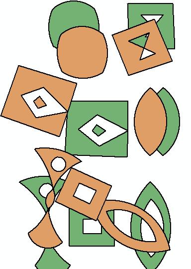
12 We want valid geometries What? - Adhere to a specified set of topological rules - Known as simple Why? - Storage in a database - Cannot rely on results from operations using non-simple geometries - Get an error - Get incorrect results How? - ArcGIS Pro and ArcMap - Check Geometry and Repair Geometry GeoProcessing tools - ArcGIS Server - IsSimple and Simplify operations - All Esri APIs have similar functionality
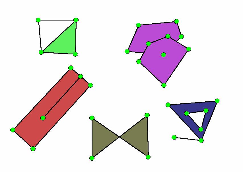
13 Non-simple Polygons
14 Simple Polygons Simplifying may add or remove vertices

15 Why do we care if geometries are simple? Demo
16 Spatial References
17 Key properties of spatial references Coordinate system - Geographic - Projected XY Resolution XY Tolerance
")
18 Coordinate Systems Geographic (GCS) Projected (PCS)
19 What is a coordinate system? An agreed upon way to describe locations Represents locations - Geographic features - Imagery - Observations such as GPS locations Common geographic framework Used to integrate geographic locations from different datasets

20 Geographic Coordinate System (GCS) Global 3D spherical surface Point referenced by longitude and latitude values
 X X < 0 Y < 0 X > 0 Y < 0")
21 Projected Coordinate System (PCS) Flat 2D surface based on a GCS Point referenced by x, y coordinates on a grid Y X < 0 Y > 0 X > 0 Y > 0 (0,0) X X < 0 Y < 0 X > 0 Y < 0
22 Coordinate System Projected Coordinate System Geographic Coordinate System Projection Linear Unit Datum Prime Meridian Projection Parameters Spheroid Angular Unit
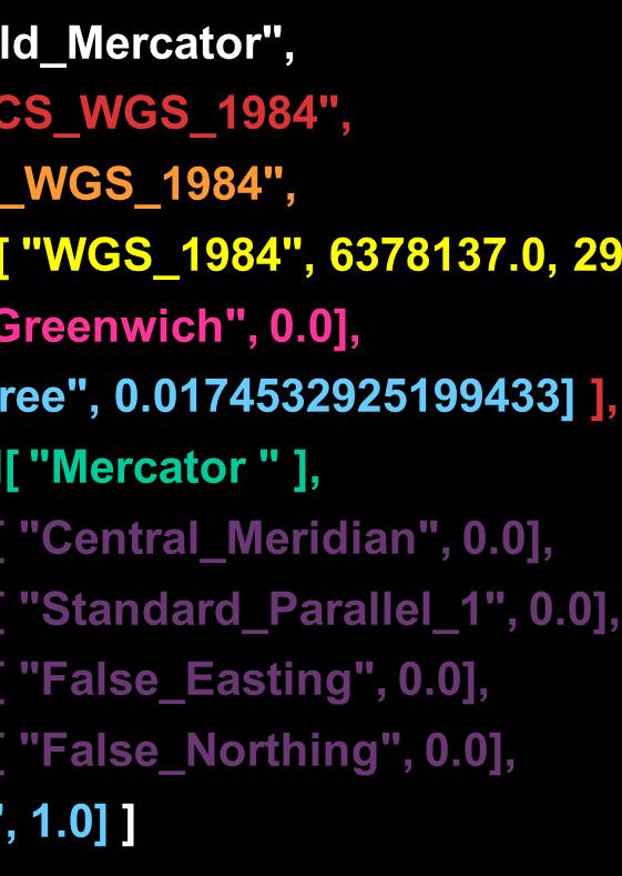
23 Geographic Coordinate System Well-Known Text (WKT) GEOGCS[ "GCS_WGS_1984", DATUM[ "D_WGS_1984", SPHEROID[ "WGS_1984", , ] ], PRIMEM[ "Greenwich", 0.0], UNIT[ "Degree", ] ]
24 What is a datum?
25 Projected Coordinate System Well-Known Text (WKT) PROJCS[ World_Mercator", GEOGCS[ "GCS_WGS_1984", DATUM[ "D_WGS_1984", SPHEROID[ "WGS_1984", , ] ], PRIMEM[ "Greenwich", 0.0], UNIT[ "Degree", ] ], PROJECTION[ "Mercator " ], PARAMETER[ "Central_Meridian", 0.0], PARAMETER[ "Standard_Parallel_1", 0.0], PARAMETER[ "False_Easting", 0.0], PARAMETER[ "False_Northing", 0.0], UNIT[ Meter", 1.0] ]
26 Well-Known ID (WKID) Every predefined coordinate system has a WKID - For example, GCS_WGS_1984, WKID = 4326 WKID < is EPSG assigned - EPSG Geodetic Parameter Dataset, WKID > is Esri assigned - Esri WKID may change - Esri EPSG - Old WKID will still work - Example, Web Mercator

27 All projections have some distortion Web Mercator Projection
28 What is happening when we project data? Case 1: Both PCSs contain the same GCS PCS A1 PCS A2 (x, y) GCS A (lon, lat) (λ, φ)
29 What is happening when we project data? Case 2: Each PCS contains a different GCS PCS A1 PCS B1 (x, y) Projection Projection GCS A Geographic Transformation GCS B (lon, lat) (λ, φ)
30 Geographic Transformations (GT) Convert from one GCS to another GCS Suitable for a particular area Defined in a particular direction - For example, NAD27 to WGS84 - All are reversible May be more than one applicable GT

31 Why do we need to transform our data? European Datum 1950 vs. World Geodetic System 1984

32 There are 38 transformations between GCS_North_American_1927 and GCS_WGS_1984 Which is best? Depends on the region covered by your data

33 How do I find transformations? Demo

34 Tolerance and Resolution
35 XY Tolerance Minimum distance between coordinates Comes into play when we are working with geometries - Make sure our geometries are simple - Topological operations - For example, Buffer, Symmetric Difference, Union, Intersection - Relational operations - For example, Disjoint, Touches, Overlaps, Crosses, Within - Editing operations


36 XY Tolerance Default value = meters or equivalent Do these two points intersect? Yes, since the distance between them is less than the tolerance.

37 XY Tolerance Editing Merge operation

38 Merge Polygons Demo

39 XY Resolution Numeric precision used to store x, y coordinate values All coordinates lie on coordinate grid Default value is meters or equivalent - x 1 = , x 2 = stored as unique coordinate values - x 1 = , x 2 = both stored as Each square in grid is x
40 Tolerance vs. Resolution Tolerance Default = meter or equivalent Used when doing something with geometry Determines if points are considered equal Resolution Default = meter or equivalent Used to store geometry in database Determines number of decimal places to store Resolution should be no greater than 1/10 of the tolerance Highly recommended to use default values!
41 What do spatial references have to do with geometries? Geometry is a collection of points Spatial reference determines - where the coordinates are placed - how the coordinates interact with each other
42 How does a spatial reference affect a geometry? We need to know where to put the geometry on the map Could change the geometry visually or structurally An operation on features may give different results

43 Where is my data? Demo


44 Spatial reference can change the geometry Here we have the same geometry in 4 different spatial references WGS 84 Azimuthal Equidistant South Pole Gnomonic Cube

45 An operation on features may give different results depending on the spatial reference For example, Buffer operation

46 Buffer and Spatial Reference Demo
47 That s all folks! Don t forget to fill out the survey Understanding and Using Geometry, Projections, and Spatial Reference Systems in ArcGIS Rob Juergens, Melita Kennedy, Annette Locke
48 Resources Desktop Guide Books Map projections Developer Help List of ArcGIS APIs Lining Up Data in ArcGIS, Margaret Maher ESRI Technical paper: Understanding Coordinate Management in the Geodatabase ESRI Technical paper: Understanding Geometric Processing in ArcGIS
49 Demos All the demos are on GitHub at ArcMap Demos - DevSummit2015.gdb - How do I find transformations? (Project.mxd) - Merge polygons (MergePolygons.mxd) - QM.gdb - Where is my data? (QM.mxd) JavaScript Demos - Why do we care if geometries are simple? (SimplifyPolygon.html) - Buffer and Spatial Reference (GeodesicBufferWebMercator.html and GeodesicBufferOther.html)
Understanding and Using Geometry, Projections, and Spatial Reference Systems in ArcGIS Annette Locke, Rob Juergens
 Understanding and Using Geometry, Projections, and Spatial Reference Systems in ArcGIS Annette Locke, Rob Juergens Introduction We present fundamental concepts necessary for the correct and efficient use
Well Unknown ID AKA EPSG: 3857
 Well Unknown ID AKA EPSG: 3857 Pamela Kanu November 2016 WGS 1984 WEB MERCATOR ALIASES: AUXILIARY SPHERE, WKID: 3857, WKID: 102100, WKID: 102113, SHERICAL MERCATOR, WGS 84/PSEUDO-MERCATOR, OPEN LAYERS:
Geoapplications development Control work 1 (2017, Fall)
") Page 1 Geoapplications development Control work 1 (2017, Fall) Author: Antonio Rodriges, Oct. 2017 http://rgeo.wikience.org/ Surname, name, patronymic: Group: Date: Signature: Select all correct statements.
Page 1 Geoapplications development Control work 1 (2017, Fall) Author: Antonio Rodriges, Oct. 2017 http://rgeo.wikience.org/ Surname, name, patronymic: Group: Date: Signature: Select all correct statements.
file:///c:/users/c_harmak/appdata/local/temp/arc8f36/tmp308d.tmp.htm
 Page 1 of 6 FireDistricts_CoB Shapefile Tags Bradenton, boundary, fire districts Summary The best current representation of the City of Bradenton Florida's fire districts and sub-districts. Description
Exercise One: Creating A Map Of Species Distribution For A Publication
 --- Chapter three --- Exercise One: Creating A Map Of Species Distribution For A Publication One of the first, and most common, tasks you will want to do in using GIS is to produce maps for use in presentations,
This will display various panes in a window.
 Map Map projections in ArcMap can be a bit confusing, because the program often automatically reprojects data for display, and there are a ways to permanently project data to new data sets. This describes
Geocoding and Georeferencing. Scott Bell GIS Institute
 Geocoding and Georeferencing Scott Bell GIS Institute Learning Outcomes Define coordinate system and map projection Relate coordinate systems and map projections Distinguish between defining and changing
Topology in the Geodatabase: An Introduction
 Topology in the Geodatabase: An Introduction Colin Zwicker Erik Hoel ESRI Super Secret Topology Laboratory, May 2016 Agenda ArcGIS Topology defined Validating a topology Editing a topology Geoprocessing
Basic Tasks in ArcGIS 10.3.x
 Basic Tasks in ArcGIS 10.3.x This guide provides instructions for performing a few basic tasks in ArcGIS 10.3.1, such as adding data to a map document, viewing and changing coordinate system information,
Elec_ISO_LMP_PricingPoints
 Page 1 of 7 Elec_ISO_LMP_PricingPoints Shapefile Tags locational marginal pricing, lmp, independent system operator, iso, nodal, trade, market Summary The S&P Global Platts ISO Nodal Pricing Points geospatial
Exercise One: Estimating The Home Range Of An Individual Animal Using A Minimum Convex Polygon (MCP)
") --- Chapter Three --- Exercise One: Estimating The Home Range Of An Individual Animal Using A Minimum Convex Polygon (MCP) In many populations, different individuals will use different parts of its range.
--- Chapter Three --- Exercise One: Estimating The Home Range Of An Individual Animal Using A Minimum Convex Polygon (MCP) In many populations, different individuals will use different parts of its range.
Geometric Correction of Imagery
 Geometric Correction of Imagery Geometric Correction of Imagery Present by: Dr.Weerakaset Suanpaga D.Eng(RS&GIS) The intent is to compensate for the distortions introduced by a variety of factors, so that
Coordinate Transformation for Macau Data Using ArcGIS for Desktop
 Coordinate Transformation for Macau Data Using ArcGIS for Desktop Article ID : TT100062 Software : ArcGIS 10.2 for Desktop Platform : Windows 7, Windows 8, Windows Server 2003, Windows Server 2008/R2 Date
ArcMap Editing Tips and Tricks. Sean Jones
 ArcMap Editing Tips and Tricks Sean Jones Overview Topics - Tuning your editing map - Creating features - Editing features and attributes - Aligning and editing coincident features - Addins Format - Software
Yandex.Maps API Background theory
 8.02.2018 .. Version 1.0 Document build date: 8.02.2018. This volume is a part of Yandex technical documentation. Yandex helpdesk site: http://help.yandex.ru 2008 2018 Yandex LLC. All rights reserved.
Priemere Power. Geodetic Assistant
 Priemere Power Geodetic Assistant A custom Add-In (extension) to Educate & Inform the ArcGIS User by: Rich Priem Rich@Priemere.com 281-451-8818 APSG-30 Conference September 25, 2013 Awarene$$ Messsages
Navigation coordinate systems
 Lecture 3 Navigation coordinate systems Topic items: 1. Basic Coordinate Systems. 2. Plane Cartesian Coordinate Systems. 3. Polar Coordinate Systems. 4. Earth-Based Locational Reference Systems. 5. Reference
LECTURE TWO Representations, Projections and Coordinates
 LECTURE TWO Representations, Projections and Coordinates GEOGRAPHIC COORDINATE SYSTEMS Why project? What is the difference between a Geographic and Projected coordinate system? PROJECTED COORDINATE SYSTEMS
Welcome to NR402 GIS Applications in Natural Resources. This course consists of 9 lessons, including Power point presentations, demonstrations,
 Welcome to NR402 GIS Applications in Natural Resources. This course consists of 9 lessons, including Power point presentations, demonstrations, readings, and hands on GIS lab exercises. Following the last
Exercise 4: Import Tabular GPS Data and Digitizing
 Exercise 4: Import Tabular GPS Data and Digitizing You can create NEW GIS data layers by digitizing on screen with an aerial photograph or other image as a back-drop. You can also digitize using imported
Global_Price_Assessments
 Page 1 of 6 Global_Price_Assessments Shapefile Thumbnail Not Available Tags assessments, platts, crude oil, global, crude, petroleum Summary The S&P Global Platts Global Price Assessment geospatial data
Elec_ISO_RTO_Regions
 Page 1 of 8 Elec_ISO_RTO_Regions Shapefile Tags independent system operator, iso, regional transmission organization, rto, utilitiescommunication, economy Summary The S&P Global Platts Independent System
Announcements. Data Sources a list of data files and their sources, an example of what I am looking for:
 Data Announcements Data Sources a list of data files and their sources, an example of what I am looking for: Source Map of Bangor MEGIS NG911 road file for Bangor MEGIS Tax maps for Bangor City Hall, may
Fundamentals of Structural Geology Exercise: concepts from chapter 2
 0B Reading: Fundamentals of Structural Geology, Ch 2 1) Develop a MATLAB script that plots the spherical datum (Fig. 2.1a) with unit radius as a wire-frame diagram using lines of constant latitude and
Moving Dynamic Segmentation to the Server: Linear Referencing for Web- Based Applications
 Moving Dynamic Segmentation to the Server: Linear Referencing for Web- Based Applications Paper 6.4.2 Graham Stickler and Rob Coupe Exor Corporation Contents Why move things to the database Oracle spatial
Fractionation_Facilities
 Page 1 of 8 Fractionation_Facilities Shapefile Thumbnail Not Available Tags ngl, natural gas liquids, gas processing, fractionators Summary The S&P Global Platts Fractionation facilities geospatial data
Editing with ArcGIS. Contents
 Editing with ArcGIS This tutorial is designed to introduce you to the basic editing tools used in ArcMap for the both the creation and modification of geospatial data. Editing is an essential skill for
Mississippi Public Schools 2015
 Mississippi Public Schools 2015 Shapefile and geodatabase Tags education, administrative, schools, public, K-12 Summary To add to the state data clearinghouse the Mississippi public schools point feature.
Migrating Data to the Parcel Fabric. Christine Leslie Amir Bar-Maor
 Migrating Data to the Parcel Fabric Christine Leslie Amir Bar-Maor What is a parcel fabric? Dataset of related feature classes and tables - Polygons, lines, points, plans, etc. - Predefined system attributes
ArcGIS Pro Editing: An Introduction. Jennifer Cadkin & Phil Sanchez
 ArcGIS Pro Editing: An Introduction Jennifer Cadkin & Phil Sanchez See Us Here WORKSHOP ArcGIS Pro Editing: An Introduction LOCATION SDCC - Ballroom 20 D TIME FRAME Thursday 10:00 11:00 ArcGIS Pro: 3D
GEOGRAPHIC INFORMATION SYSTEMS Lecture 17: Geoprocessing and Spatial Analysis
 GEOGRAPHIC INFORMATION SYSTEMS Lecture 17: and Spatial Analysis tools are commonly used tools that we normally use to prepare data for further analysis. In ArcMap, the most commonly used tools appear in
Geog 469 GIS Workshop. System Requirements
 Geog 469 GIS Workshop System Requirements Outline 1. What are some fundamental issues associated with system requirements? 2. What are your GIS data requirements? 3. What are your GIS software requirements?
ArcGIS Data Reviewer: Ensuring Accurate and Complete Data to Meet Your Mission. John Grammer Kevin Pusey
 ArcGIS Data Reviewer: Ensuring Accurate and Complete Data to Meet Your Mission John Grammer Kevin Pusey Workshop agenda Defining data quality What is ArcGIS Data Reviewer? Automated review Semi-automated
Real Geodetic Map (Map without Projection) Abstract Keywords: 1. Introduction
 Abstract Keywords: 1. Introduction") Real ( without Projection) Ahmad Shaker 1 Abdullah Saad 1 Abdurrahman Arafa 2* 1.Surveying Dep., Shoubra Faculty of Engineering, Benha University, Egypt 2.Manager of Surveying Dep. in Horse Company. Egypt
Real ( without Projection) Ahmad Shaker 1 Abdullah Saad 1 Abdurrahman Arafa 2* 1.Surveying Dep., Shoubra Faculty of Engineering, Benha University, Egypt 2.Manager of Surveying Dep. in Horse Company. Egypt
Real-Time & Big Data GIS: Leveraging the spatiotemporal big data store
 Real-Time & Big Data GIS: Leveraging the spatiotemporal big data store Suzanne Foss Product Manager, Esri sfoss@esri.com Ricardo Trujillo Real-Time & Big Data GIS Developer, Esri rtrujillo@esri.com @rtrujill007
Enterprise GIS. GIS Data Collection Standards. and. Geospatial Data Standards. August, 2017
 Enterprise GIS GIS Data Collection Standards and Geospatial Data Standards August, 2017 1 Contents Section 1 1.1 GIS Data Collection Standards 1.2 GPS/GNSS Data Collection and Delivery Standards 1.3 Field
Editing & Maintaining Parcels with ArcMap. Christine Leslie Amy Andis
 Editing & Maintaining Parcels with ArcMap Christine Leslie Amy Andis What to expect An introduction to the parcel fabric A detailed explanation of the parcel fabric data model General editing techniques
Geometric Rectification of Remote Sensing Images
 Geometric Rectification of Remote Sensing Images Airborne TerrestriaL Applications Sensor (ATLAS) Nine flight paths were recorded over the city of Providence. 1 True color ATLAS image (bands 4, 2, 1 in
ArcGIS Pro Editing. Jennifer Cadkin & Phil Sanchez
 ArcGIS Pro Editing Jennifer Cadkin & Phil Sanchez ArcGIS Pro Editing Overview Provides tools that allow you to maintain, update, and create new data - Modifying geometry, drawing new features - Entering
I. An Intro to ArcMap Version 9.3 and 10. 1) Arc Map is basically a build your own Google map
 Arc Map is basically a build your own Google map") I. An Intro to ArcMap Version 9.3 and 10 What is Arc Map? 1) Arc Map is basically a build your own Google map a. Display and manage geo-spatial data (maps, images, points that have a geographic location)
I. An Intro to ArcMap Version 9.3 and 10 What is Arc Map? 1) Arc Map is basically a build your own Google map a. Display and manage geo-spatial data (maps, images, points that have a geographic location)
Introduction to Geodatabase and Spatial Management in ArcGIS. Craig Gillgrass Esri
 Introduction to Geodatabase and Spatial Management in ArcGIS Craig Gillgrass Esri Session Path The Geodatabase - What is it? - Why use it? - What types are there? - What can I do with it? Query Layers
layers in a raster model
 layers in a raster model Layer 1 Layer 2 layers in an vector-based model (1) Layer 2 Layer 1 layers in an vector-based model (2) raster versus vector data model Raster model Vector model Simple data structure
Exercise 5: Import Tabular GPS Data and Digitizing
 Exercise 5: Import Tabular GPS Data and Digitizing You can create NEW GIS data layers by digitizing on screen with an aerial photograph or other image as a back-drop. You can also digitize using imported
Legionnaires GIS. Legionnaires' GIS User Guide
 Legionnaires GIS Legionnaires' GIS User Guide September 2016 Contents Contents Introduction... 4 Introducing the Legionnaires GIS interface... 5 Layers... 6 Basemaps... 7 Measurements... 8 Searching for
Grade 6 Math Circles October 16 & Non-Euclidean Geometry and the Globe
 Faculty of Mathematics Waterloo, Ontario N2L 3G1 Centre for Education in Mathematics and Computing Grade 6 Math Circles October 16 & 17 2018 Non-Euclidean Geometry and the Globe (Euclidean) Geometry Review:
Hamilton County Draw Widget Measurements Page 2 of 11
 Hamilton County Draw Widget Measurements Larry Stout June 11, 2013 Introduction The Hamilton County Draw Widget is based on the Draw Widget from Version 2 of the Esri Flex Viewer. We have made several
Streamlining Editing Workflows. Amber Bethell
 Streamlining Editing Workflows Amber Bethell Workflow for solving geographic problems Ask a question Create or acquire data Validate and update data Analyze data Create cartographic product Act upon knowledge
Feature Analysis. In this lab you will create a map of all spruce sawtimber or pole stands with an area greater than 5 hectares that are
 NRM338 Fall 2017 Lab11 Feature Analysis Page 1 of 7 Feature Analysis In this lab you will create a map of all spruce sawtimber or pole stands with an area greater than 5 hectares that are Within 1000 meters
BROWSER. LuciadRIA DATA SHEET
 BROWSER LuciadRIA DATA SHEET V2017 V2017.0 DATA SHEET LuciadRIA is the answer to today s demands for powerful, lightweight applications in the browser. Driven by today s most advanced web technologies,
ArcMap - EXPLORING THE DATABASE Part I. SPATIAL DATA FORMATS Part II
 Week 5 ArcMap - EXPLORING THE DATABASE Part I SPATIAL DATA FORMATS Part II topics of the week Exploring the Database More on the Table of Contents Exploration tools Identify, Find, Measure, Map tips, Hyperlink,
THE FUTURE OF STATE PLANE COORDINATES AT ODOT
 THE FUTURE OF STATE PLANE COORDINATES AT ODOT BY: RAY FOOS P.S. AND BRIAN MEADE P.S. THE OHIO DEPARTMENT OF TRANSPORTATION WORKING WITH STATE PLANE COORDINATES OR HOW TO MAKE THE EARTH FLAT SURVEYORS AND
GRASS GIS - Introduction
 GRASS GIS - Introduction What is a GIS A system for managing geographic data. Information about the shapes of objects. Information about attributes of those objects. Spatial variation of measurements across
Topology in the Geodatabase an Introduction. Erik Hoel Doug Morgenthaler
 Topology in the Geodatabase an Introduction Erik Hoel Doug Morgenthaler ESRI Super Secret Topology Laboratory, May 2012 Agenda ArcGIS Topology defined Validating a topology Editing a topology Geoprocessing
Desktop Mapping: Creating Vector Tiles. Craig Williams &
 Desktop Mapping: Creating Vector Tiles Craig Williams & Edie Punt @williamscraigm @epunt Overview Why vector tiles? Vector tiles in ArcGIS ArcGIS vector tile basemaps Consuming and styling vector tiles
PUG List 2009 Geodetics & What s New in projection engine. Melita Kennedy
 PUG List 2009 Geodetics & What s New in projection engine Melita Kennedy 249/106: GRIDs, workstation versus ArcGIS coordsys GRIDs use the workstation coordsys format Spatial Analyst uses grids internally
Working with Feature Layers. Russell Brennan Gary MacDougall
 Working with Feature Layers Russell Brennan Gary MacDougall Working with Feature Layers Session will focus on feature access and editing Highlight new features added over the last few releases Agenda Introduction
Desktop Mapping: Creating Vector Tiles. Craig Williams
 Desktop Mapping: Creating Vector Tiles Craig Williams Edie Punt @williamscraigm @epunt Overview Why vector tiles? Vector tiles in ArcGIS ArcGIS vector tile basemaps Consuming and styling vector tiles Overview
GIS IN ECOLOGY: CREATING RESEARCH MAPS
 GIS IN ECOLOGY: CREATING RESEARCH MAPS Contents Introduction... 2 Elements of Cartography... 2 Course Data Sources... 3 Tasks... 3 Establishing the Map Document... 3 Laying Out the Map... 5 Exporting Your
HP-33S Calculator Program TM 1
 Programmer: Dr. Bill Hazelton Date: March, 2005. Line Instruction Line Instruction Line Instruction T0001 LBL T U0022 STOP U0061 x < > y T0002 CL Σ U0023 RCL U U0062 x < 0? T0003 INPUT K U0024 RCL E U0063
Building Geoprocessing Tools with Python: Beyond the Basics. Dave Wynne
 Building Geoprocessing Tools with Python: Beyond the Basics Dave Wynne Building Geoprocessing Tools with Python: Getting Started Subhead Here This session will focus on creating polished, well-designed
Terminals. Shapefile. Thumbnail Not Available. Tags barge, rail, truck, tanker, ports, terminals, crude, refined, products
 Page 1 of 11 Terminals Shapefile Thumbnail Not Available Tags barge, rail, truck, tanker, ports, terminals, crude, refined, products Summary The S&P Global Platts Oil Terminals geospatial data layer was
GEO 465/565 - Lab 7 Working with GTOPO30 Data in ArcGIS 9
 GEO 465/565 - Lab 7 Working with GTOPO30 Data in ArcGIS 9 This lab explains how work with a Global 30-Arc-Second (GTOPO30) digital elevation model (DEM) from the U.S. Geological Survey. This dataset can
4. If you are prompted to enable hardware acceleration to improve performance, click
 Exercise 1a: Creating new points ArcGIS 10 Complexity: Beginner Data Requirement: ArcGIS Tutorial Data Setup About creating new points In this exercise, you will use an aerial photograph to create a new
Accessing and Administering your Enterprise Geodatabase through SQL and Python
 Accessing and Administering your Enterprise Geodatabase through SQL and Python Brent Pierce @brent_pierce Russell Brennan @russellbrennan hashtag: #sqlpy Assumptions Basic knowledge of SQL, Python and
Integrating CAD Data with ArcGIS
 Integrating CAD Data with ArcGIS Agenda An Overview of CAD Drawings CAD Data Structure in ArcGIS Visualization Georeferencing Data Conversion ArcGIS for AutoCAD Q & A CAD Drawings - Overview Widely used
Geographic Information Systems. using QGIS
 Geographic Information Systems using QGIS 1 - INTRODUCTION Generalities A GIS (Geographic Information System) consists of: -Computer hardware -Computer software - Digital Data Generalities GIS softwares
Understanding ArcGIS Pipeline Referencing for Vertically Integrated Gas Companies. GeoConX 2017 September 7, 2017
 Understanding ArcGIS Pipeline Referencing for Vertically Integrated Gas Companies GeoConX 2017 September 7, 2017 The Asset Intelligence Imperative GOAL The necessity to learn ever more, in as close to
4/7/2009. Model: Abstraction of reality following formal rules e.g. Euclidean space for physical space
 Model: Abstraction of reality following formal rules e.g. Euclidean space for physical space At different levels: mathematical model (Euclidean space) conceptual design model (ER model) data model (design)
UTM Geo Map APP Quick Start (Version 1.2)
") UTM Geo Map APP Quick Start (Version 1.2) Measure Points (Marker) You can measure points of coordinate base on GPS or position on the Maps and save marker into database for unlimited number using Real-time
UTM Geo Map APP Quick Start (Version 1.2) Measure Points (Marker) You can measure points of coordinate base on GPS or position on the Maps and save marker into database for unlimited number using Real-time
Advanced Parcel Editing. Amy Andis Tim Hodson
 Advanced Parcel Editing Amy Andis Tim Hodson Overview What to expect in this technical workshop Review of the Parcel Fabric Data Model Advanced Tips and tricks for Parcel entry Assessing Quality of Parcel
HP-35s Calculator Program Closure 7A
 Traverse Program using Latitude and Longitude and the Gauss Mid-Latitude Formulae Programmer: Dr. Bill Hazelton Date: March, 2008. Version: 1.0 Line Instruction Display User Programming Instructions J001
Lecture 8. Vector Data Analyses. Tomislav Sapic GIS Technologist Faculty of Natural Resources Management Lakehead University
 Lecture 8 Vector Data Analyses Tomislav Sapic GIS Technologist Faculty of Natural Resources Management Lakehead University Vector Data Analysis Vector data analysis involves one or a combination of: Measuring
ArcGIS for Geoscientists
 School of Geosciences ArcGIS for Geoscientists R. Armit & T. Carmichael GIS A geographic information system (GIS) is a system designed to capture, store, manipulate, analyze, manage, and present all types
ArcGIS Extension User's Guide
 ArcGIS Extension 2010 - User's Guide Table of Contents OpenSpirit ArcGIS Extension 2010... 1 Installation ( ArcGIS 9.3 or 9.3.1)... 3 Prerequisites... 3 Installation Steps... 3 Installation ( ArcGIS 10)...
Calculate a Distance Matrix of Locations along River Network
 Calculate a Distance Matrix of Locations along River Network These instructions enable you to measure the length of line segments between points, which is much more useful than simple straight-line distances
Data Assembly, Part II. GIS Cyberinfrastructure Module Day 4
 Data Assembly, Part II GIS Cyberinfrastructure Module Day 4 Objectives Continuation of effective troubleshooting Create shapefiles for analysis with buffers, union, and dissolve functions Calculate polygon
1. Start ArcMap by going to the Start menu > All Programs > ArcGIS > ArcMap.
 Learning ArcGIS: Introduction to ArcMap 10.1 The Map Document Feature Manipulation Navigating ArcMap Map Documents, Layers, and Features Shapes, Location, and Attribute Data Symbology Zoom, Pan and Map
Utility Network Management in ArcGIS: Migrating Your Data to the Utility Network. John Alsup & John Long
 Utility Network Management in ArcGIS: Migrating Your Data to the Utility Network John Alsup & John Long Presentation Outline Utility Network Preparation - Migration Patterns - Understanding the Asset Package
COORDINATE TRANSFORMATION. Lecture 6
 COORDINATE TRANSFORMATION Lecture 6 SGU 1053 SURVEY COMPUTATION 1 Introduction Geomatic professional are mostly confronted in their work with transformations from one two/three-dimensional coordinate system
City of Monterey Critical Infrastructure and Key Resources
 City of Monterey Critical Infrastructure and Key Resources Naval Postgraduate School Earthquake Response Project Playbook #: RSC-03 Revised 10/15/2013 Approved for public release; distribution is unlimited
GEOGRAPHIC INFORMATION SYSTEMS Lecture 02: Feature Types and Data Models
 GEOGRAPHIC INFORMATION SYSTEMS Lecture 02: Feature Types and Data Models Feature Types and Data Models How Does a GIS Work? - a GIS operates on the premise that all of the features in the real world can
Making ArcGIS Work for You. Elizabeth Cook USDA-NRCS GIS Specialist Columbia, MO
 Making ArcGIS Work for You Elizabeth Cook USDA-NRCS GIS Specialist Columbia, MO 1 Topics Using ArcMap beyond the Toolkit buttons GIS data formats Attributes and what you can do with them Calculating Acres
Bringing your Data to Life in the ArcGIS API for JavaScript: Vector Tiles. Craig Williams &
 Bringing your Data to Life in the ArcGIS API for JavaScript: Vector Tiles Craig Williams & Rene Rubalcava @williamscraigm @odoenet Overview Why vector tiles? Vector tiles in ArcGIS ArcGIS vector tile basemaps
SPATIAL DATA MODELS Introduction to GIS Winter 2015
 SPATIAL DATA MODELS Introduction to GIS Winter 2015 GIS Data Organization The basics Data can be organized in a variety of ways Spatial location, content (attributes), frequency of use Come up with a system
Alberta-wide ALOS DSM "ALOS_DSM15.tif", "ALOS_DSM15_c6.tif"
 Alberta-wide ALOS DSM "ALOS_DSM15.tif", "ALOS_DSM15_c6.tif" Alberta Biodiversity Monitoring Institute Geospatial Centre May 2017 Contents 1. Overview... 2 1.1. Summary... 2 1.2 Description... 2 1.3 Credits...
Grade 6 Math Circles October 16 & Non-Euclidean Geometry and the Globe
 Faculty of Mathematics Waterloo, Ontario N2L 3G1 Centre for Education in Mathematics and Computing Grade 6 Math Circles October 16 & 17 2018 Non-Euclidean Geometry and the Globe (Euclidean) Geometry Review:
Cartographic Techniques and Representations
 Cartographic Techniques and Representations NEARC 2007 ESRI Technical Session ESRI, Boston Overview of Presentation Labeling and Annotation Masking Layout Tips Cartographic Representations Labeling versus
Maintain Geodatabase
 Maintain Geodatabase An application for Spatializing acquire and other Non-spatial Databases Dennis Geasan GIS Technologies Haines, AK and Reno, NV dgeasan@gmail.com 775-750-1619 Introduction The challenge
QGIS Tutorials Documentation
 QGIS Tutorials Documentation Release 0.1 Nathaniel Roth November 30, 2016 Contents 1 Installation 3 1.1 Basic Installation............................................. 3 1.2 Advanced Installation..........................................
CSE 512 Course Project Operation Requirements
 CSE 512 Course Project Operation Requirements 1. Operation Checklist 1) Geometry union 2) Geometry convex hull 3) Geometry farthest pair 4) Geometry closest pair 5) Spatial range query 6) Spatial join
Reduction of Field Observations
 Reduction of Field Observations GNSS/GPS measurements or Latitudes, Longitudes, HAE: We re interested in projected coordinates, e.g., State Plane Survey measurements in a projected coordinate system, on
WHERE THEORY MEETS PRACTICE
 world from others, leica geosystems WHERE THEORY MEETS PRACTICE A NEW BULLETIN COLUMN BY CHARLES GHILANI ON PRACTICAL ASPECTS OF SURVEYING WITH A THEORETICAL SLANT february 2012 ² ACSM BULLETIN ² 27 USGS
ArcGIS Desktop The Road Ahead. Amadea Azerki
 ArcGIS Desktop The Road Ahead Amadea Azerki Agenda An Overview of ArcGIS 10 Desktop Enhancements User Interface Mapping Editing Analysis Sharing Q & A ArcGIS 10 Overview Focuses on Usability and Productivity
Editing Versioned Geodatabases : An Introduction
 Esri International User Conference San Diego, California Technical Workshops July 24, 2012 Editing Versioned Geodatabases : An Introduction Cheryl Cleghorn Shawn Thorne Assumptions: Basic knowledge of
Geoprocessing and georeferencing raster data
 Geoprocessing and georeferencing raster data Raster conversion tools Geoprocessing tools ArcCatalog tools ESRI Grid GDB Raster Raster Dataset Raster Catalog Erdas IMAGINE TIFF ArcMap - raster projection
Chapter 7. A Quick Tour of ArcGIS Pro
 Chapter 7 A Quick Tour of ArcGIS Pro Skills you will learn: This tutorial is intended to get you going using ArcGIS Pro, a new desktop application that is part of ArcGIS Desktop. A separate tutorial gives
Smart GIS Course. Developed By. Mohamed Elsayed Elshayal. Elshayal Smart GIS Map Editor and Surface Analysis. First Arabian GIS Software
 Smart GIS Course Developed By Mohamed Elsayed Elshayal Elshayal Smart GIS Map Editor and Surface Analysis First Arabian GIS Software http://www.freesmartgis.blogspot.com/ http://tech.groups.yahoo.com/group/elshayalsmartgis/
3.1 Units. Angle Unit. Direction Reference
 Various settings allow the user to configure the software to function to his/her preference. It is important to review all the settings prior to using the software to ensure they are set to produce the
Open Source Cloud Map User Guide
 Open Source Cloud Map User Guide Table of Contents Map Page... 1 Static Mercator Map... 1 Customizable Map... 1 Title Bar... 2 Toolbar... 2 Non Toolbar Navigation... 3 Map Window... 3 Layers / Legend Window...
Key Terms. Attribute join Target table Join table Spatial join
 Key Terms Attribute join Target table Join table Spatial join Lect 10A Building Geodatabase Create a new file geodatabase Map x,y data Convert shape files to geodatabase feature classes Spatial Data Formats