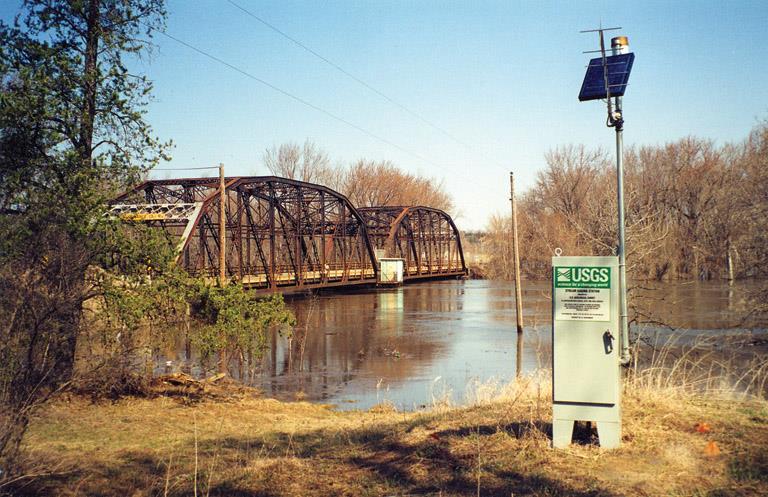
2014 AWRA Annual Water Resources Conference November 5, 2014 Tysons Corner, VA
|
|
|
- Hilda Kennedy
- 6 years ago
- Views:
Transcription

1 2014 AWRA Annual Water Resources Conference November 5, 2014 Tysons Corner, VA
2 HEC-RAS Overview, History, & Future How HEC-RAS Works Model Development Standard FEMA Assumptions Building A Model FEMA Levels of Study Model Results & Outputs Leveraging FEMA HEC-RAS Models Ways to leverage How to acquire FEMA Models
3 HEC-RAS is the most frequently used and widely accepted model for developing FEMA flood profiles and mapping. There are hundreds of thousands of models that have been developed to support FEMA Flood Insurance Studies throughout the United States. Flood studies don t just generate models, but also produce valuable supporting data: Terrain (LiDAR & Contours) Survey Field investigation data Models and supporting data are available to the public.
4 HEC-RAS is a River Analysis System modeling software, developed by U.S. Army Corps of Engineers, Hydrologic Engineering Center HEC-RAS What can we do with the software? Perform One-Dimensional Hydraulic Models Steady & Unsteady Flow Analysis Sediment Transport Analysis Water Quality Analysis Hydraulic Design and much, much more


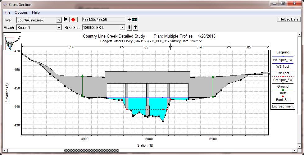
5 Cross sections are the basic building blocks of HEC-RAS hydraulic modeling. Bridges Floodplains Culverts Dams
")
")
6 OldGen (HEC-2) NexGen (HEC-RAS)


7 HEC-RAS 5.0 will offer combined 1D and 2D modeling, including the ability to model hydraulic structures inside of 2D flow areas.
8 One-dimensional Hydraulic Model (1-D) A mathematical model that computes hydraulic conditions of flow for a constant discharge and only calculates the hydraulics in terms of flow depth variations and velocity in the direction of the stream line. Flow Path
9 HEC-RAS basic methodology is to compare energy between cross sections to determine the water surface elevation of the next section. This is referred to as a direct step method calculation. Basic Equations are: Energy Equation Continuity Equation V2 A2 V1 A1 Z: elevation of the bottom of the channel Y: elevation of the water surface V: flow velocity : coefficient g: gravity h e : head losses A: area of cross section Z V 2 g V 2 g Y2 2 Z1 Y1 1 he
10 HEC-RAS Basic Assumptions: 1. Cross sections have one water surface elevation (WSE) along the entire length. 2. Average water velocity and depth is adequate to determine WSE. 3. Water only flows perpendicular to the cross section. 4. Flow Q is constant in any given set of calculations.


11 2 basic model inputs Hydrology - Flows Floodplain Geometry & Characteristics Cross Sections Stream Line Structures HEC-RAS Model


12 Two main sources of flows are: Regression Hydrology Rainfall-Runoff Modeling


13 Where does the information come from to build geometry? Base Terrain Data Landuse & Imagery


14 Where does the information come from to build these models? Survey & As-builts Field Visits
 4.")
15 FEMA Standard Assumptions: 1. Subcritical flow 2. Steady state flow 3. Profiles are smooth and ever rising (no drawdowns) 4. Volume is not considered
16 FEMA study methods Study Method Detailed Methods Limited Detail Studies Methods Approximate Methods Redelineated (Detailed) Products (Results) Floodplains, BFEs, & Floodway Floodplain & BFEs Floodplain Updated Floodplains, Unchanged BFEs & Floodway Base Terrain High-quality LiDAR or survey High-quality LiDAR or survey Typically DEM Newer and original Terrain Channel Geometry Surveyed Channels No survey for channels No survey for channels Existing Model Structure Geometry Surveyed Structures Limited structure survey No surveyed structures Existing Model Flow Data Regression or Rainfall-runoff Regression or Rainfall-runoff Regression Existing Flow Data Model Availability Definitely Yes If you re lucky Often HEC-2


17 HEC-RAS has over 20 standard output results table


18 Outputs can be visualized in plan or profile views

 to delineate")

19 Water Surface Profiles can be converted to mapping products Profiles are combined with a terrain model (DEM or TIN) to delineate Special Flood Hazard Areas. Floodplains Depth Grids Velocity Grids Elevation (BFE) Grids Etc
20 Model can be used out of the box for: Sediment transport and scour modeling Water quality modeling (temperature, dissolved nitrogen, dissolved oxygen, etc.) Structure design Model components can be incorporated as: Base data for SWMM hydraulics Base data for a Flo-2D analysis Other useful model data: Terrain, LiDAR, & Contours Survey, Cross sections, & Structures Discharges (Flows) Gage Analysis HMS Models for rainfall-runoff modeling


21 FEMA Library All models and data (if available) Fee to research and collect data /fhm/st_order.shtm Map Service Center Maps and Mapping Products Effective DFIRMs GIS Layers for cross sections, floodplains, depth grids, etc.
 https://www.fema.")
22 First places to look: Local community floodplain administrator State or County Agency (Emergency Management, Department of Environment & Resources) Local CTP (Cooperating Technical Partner/State) -technical-partners-ctpprogram/cooperating-technicalpartners-ctp-program


23 Data is becoming more readily available. Download Models for: NC & NC Flood Risk Information System - Harris Flood Control District - WV Flood Tool -


24 Joseph C. Kirby, P.E., CFM Technical Director, Water Resources & GIS ESP Associates, P. A Kingdom Way Suite 208 Raleigh, NC
CHAPTER 7 FLOOD HYDRAULICS & HYDROLOGIC VIVEK VERMA
 CHAPTER 7 FLOOD HYDRAULICS & HYDROLOGIC VIVEK VERMA CONTENTS 1. Flow Classification 2. Chezy s and Manning Equation 3. Specific Energy 4. Surface Water Profiles 5. Hydraulic Jump 6. HEC-RAS 7. HEC-HMS
Prepared for CIVE 401 Hydraulic Engineering By Kennard Lai, Patrick Ndolo Goy & Dr. Pierre Julien Fall 2015
 Prepared for CIVE 401 Hydraulic Engineering By Kennard Lai, Patrick Ndolo Goy & Dr. Pierre Julien Fall 2015 Contents Introduction General Philosophy Overview of Capabilities Applications Computational
2D Model Implementation for Complex Floodplain Studies. Sam Crampton, P.E., CFM Dewberry
 2D Model Implementation for Complex Floodplain Studies Sam Crampton, P.E., CFM Dewberry 2D Case Studies Case Study 1 Rain-on-Grid 2D floodplain simulation for unconfined flat topography in coastal plain
Introducion to Hydrologic Engineering Centers River Analysis System (HEC- RAS) Neena Isaac Scientist D CWPRS, Pune -24
 Neena Isaac Scientist D CWPRS, Pune -24") Introducion to Hydrologic Engineering Centers River Analysis System (HEC- RAS) Neena Isaac Scientist D CWPRS, Pune -24 One dimensional river models (1-D models) Assumptions Flow is one dimensional Streamline
Introducion to Hydrologic Engineering Centers River Analysis System (HEC- RAS) Neena Isaac Scientist D CWPRS, Pune -24 One dimensional river models (1-D models) Assumptions Flow is one dimensional Streamline
HCFCD Review Process
 HCFCD Review Process Impact Analysis Local Review LOMR Delegation Local Review This presentation will include: Why is this step important? Process Review Checklist Common Comments 2 Local Review Why is
The HEC-RAS Model Refresher
 The HEC-RAS Model Refresher Minmin Shu P.E. Transportation Review Unit Water Resources Division Michigan Department of Environmental Quality 12-6-2018 What Does the HEC-RAS Mean RAS----River Analysis System
Upper Trinity River Corridor Development Certificate Model Updates. Flood Management Task Force Meeting April 20, 2018
 Upper Trinity River Corridor Development Certificate Model Updates Flood Management Task Force Meeting April 20, 2018 Agenda Review of the Phase II Upper Trinity Watershed CDC Model Development Hydrology
2-D Hydraulic Modeling Theory & Practice
 2-D Hydraulic Modeling Theory & Practice Author: Maged A. Aboelata, PhD, PE, CFM Presenter: Heather Zhao, PE, CFM October 2017 Presentation Outline * 1-D vs. 2-D modeling * Theory of 2-D simulation * Commonly
HECRAS 2D: Are you ready for the revolution in the world of hydraulic modeling?
 HECRAS 2D: Are you ready for the revolution in the world of hydraulic modeling? Rishab Mahajan, Emily Campbell and Matt Bardol March 8, 2017 Outline Reasons for hydraulic modeling 1D Modeling 2D Modeling-
Day 1. HEC-RAS 1-D Training. Rob Keller and Mark Forest. Break (9:45 am to 10:00 am) Lunch (12:00 pm to 1:00 pm)
 Lunch (12:00 pm to 1:00 pm)") Day 1 HEC-RAS 1-D Training Rob Keller and Mark Forest Introductions and Course Objectives (8:00 am to 8:15 am) Introductions: Class and Content Module 1 Open Channel Hydraulics (8:15 am to 9:45 am) Lecture
Day 1 HEC-RAS 1-D Training Rob Keller and Mark Forest Introductions and Course Objectives (8:00 am to 8:15 am) Introductions: Class and Content Module 1 Open Channel Hydraulics (8:15 am to 9:45 am) Lecture
FEMA Floodplain Mapping
 FEMA Floodplain Mapping By Luke Sturtevant Introduction The National Flood Insurance Program (NFIP) has compiled massive databases containing information and maps of floodplains for the entire United States.
Urban Floodplain modeling- Application of Two-Dimensional Analyses to Refine Results
 Urban Floodplain modeling- Application of Two-Dimensional Analyses to Refine Results Prabharanjani Madduri, P.E., CFM Mathini Sreetharan, Ph.D., P.E., CFM Hydraulic modeling of urban areas and issues Modeling
2D Large Scale Automated Engineering for FEMA Floodplain Development in South Dakota. Eli Gruber, PE Brooke Conner, PE
 2D Large Scale Automated Engineering for FEMA Floodplain Development in South Dakota Eli Gruber, PE Brooke Conner, PE Project Acknowledgments FEMA Region 8 Staff: Brooke Conner, PE Casey Zuzak, GISP Ryan
2D Modeling for Approximate Areas. Monica S. Urisko, P.E. CFM
 2D Modeling for Approximate Areas Monica S. Urisko, P.E. CFM Ferrin P. Affleck, P.E. CFM Outline Types of Modeling Available Steady vs Unsteady 1D vs 2D Software available Basics of 2D modeling Inputs
Efficiency and Accuracy of Importing HEC RAS Datafiles into PCSWMM and SWMM5
 5 Efficiency and Accuracy of Importing HEC RAS Datafiles into PCSWMM and SWMM5 Karen Finney, Rob James, William James and Tiehong Xiao An advantage of USEPA s SWMM5 is its capability to dynamically model
Hydraulic Modeling with HEC RAS. Susan Cundiff, PE December 4, 2017
 Hydraulic Modeling with HEC RAS Susan Cundiff, PE December 4, 2017 Overview Introduction to HEC RAS Computational Procedures Building a Model Example Projects Introduction to HEC RAS U.S. Army Corps of
Objectives This tutorial shows how to use the Map Flood tool to quickly generate floodplain data.
 v. 11.0 WMS 11.0 Tutorial Creating a Objectives This tutorial shows how to use the Map Flood tool to quickly generate floodplain data. Prerequisite Tutorials Introduction to WMS Required Components Scatter
Harris County Flood Control District HEC-RAS 2D Modeling Guidelines (Standardizing HEC-RAS 2D Models for Submittal Within Harris County)
") Harris County Flood Control District HEC-RAS 2D Modeling Guidelines (Standardizing HEC-RAS 2D Models for Submittal Within Harris County) Presented by: April 27, 2017 Matthew Zeve, P.E., CFM Harris County
Harris County Flood Control District HEC-RAS 2D Modeling Guidelines (Standardizing HEC-RAS 2D Models for Submittal Within Harris County) Presented by: April 27, 2017 Matthew Zeve, P.E., CFM Harris County
INTRODUCTION TO HEC-RAS
 INTRODUCTION TO HEC-RAS HEC- RAS stands for Hydrologic Engineering Center s River Analysis System By U.S. Army Corps of Engineers One dimensional analysis of : 1. Steady flow 2. Unsteady flow 3. Sediment
Development and Evaluation of the Profile Synthesis Method for Approximate Floodplain Redelineation. Thomas A. Dickerson
 Development and Evaluation of the Profile Synthesis Method for Approximate Floodplain Redelineation Thomas A. Dickerson Thesis submitted to the faculty of the Virginia Polytechnic Institute and State University
UNDERSTAND HOW TO SET UP AND RUN A HYDRAULIC MODEL IN HEC-RAS CREATE A FLOOD INUNDATION MAP IN ARCGIS.
 CE 412/512, Spring 2017 HW9: Introduction to HEC-RAS and Floodplain Mapping Due: end of class, print and hand in. HEC-RAS is a Hydrologic Modeling System that is designed to describe the physical properties
FLOODPLAIN MODELING USING HEC-RAS
 H A E S T A D M E T H O D S FLOODPLAIN MODELING USING HEC-RAS F i r s t E d i t i o n Authors Haestad Methods Gary Dyhouse Jennifer Hatchett Jeremy Benn Managing Editor Colleen Totz Editors David Klotz,
Steady Flow Water Surface Profile Computation Using HEC-RAS
 Steady Flow Water Surface Profile Computation Using HEC-RAS Objectives The objective of the course is to enable the participants to perform water surface profile computations using computer program HEC-RAS
George Mason University Department of Civil, Environmental and Infrastructure Engineering. Dr. Celso Ferreira
 George Mason University Department of Civil, Environmental and Infrastructure Engineering Dr. Celso Ferreira Exercise Topic: HEC GeoRAS Post-Processing Objectives: This tutorial is designed to walk you
Watershed Analysis with the Hydrologic Engineering Center s River Analysis System (HEC-RAS)
") Watershed Analysis with the Hydrologic Engineering Center s River Analysis System (HEC-RAS) by Christopher R. Goodell and Gary W. Brunner PURPOSE: The objectives of this document are to provide a general
Watershed Analysis with the Hydrologic Engineering Center s River Analysis System (HEC-RAS) by Christopher R. Goodell and Gary W. Brunner PURPOSE: The objectives of this document are to provide a general
2D Hydraulic Modeling, Steering Stream Restoration Design
 2D Hydraulic Modeling, Steering Stream Restoration Design PREPARED FOR: EcoStream 2018 Stream Ecology & Restoration Conference Presented By: Matthew D. Gramza, P.E., CFM, CPESC Civil & Environmental Consultants,
WMS 9.1 Tutorial Hydraulics and Floodplain Modeling Floodplain Delineation Learn how to us the WMS floodplain delineation tools
 v. 9.1 WMS 9.1 Tutorial Hydraulics and Floodplain Modeling Floodplain Delineation Learn how to us the WMS floodplain delineation tools Objectives Experiment with the various floodplain delineation options
Comparing 2D Approaches for Complex FEMA Studies
 Comparing 2D Approaches for Complex FEMA Studies Presented by: Ted Cassidy, P.E., PH (STARR2-Dewberry) Sam Crampton, P.E., CFM (STARR2-Dewberry) Mike DePue, P.E., CFM (STARR2-Atkins) Agenda Introduction
FLOODPLAIN MODELING MANUAL. HEC-RAS Procedures for HEC-2 Modelers
 FLOODPLAIN MODELING MANUAL HEC-RAS Procedures for HEC-2 Modelers Federal Emergency Management Agency Mitigation Directorate 500 C Street, SW Washington, DC 20472 April 2002 Floodplain Modeling Manual HEC-RAS
PRACTICAL UNIT 1 exercise task
 Practical Unit 1 1 1 PRACTICAL UNIT 1 exercise task Developing a hydraulic model with HEC RAS using schematic river geometry data In the course of practical unit 1 we prepare the input for the execution
Linear Routing: Floodrouting. HEC-RAS Introduction. Brays Bayou. Uniform Open Channel Flow. v = 1 n R2/3. S S.I. units
 Linear Routing: Floodrouting HEC-RAS Introduction Shirley Clark Penn State Harrisburg Robert Pitt University of Alabama April 26, 2004 Two (2) types of floodrouting of a hydrograph Linear Muskingum Reservoir
Comparison of 1D and 2D Surface Water Models for Solid Waste Facilities. Garth R. Bowers, P.E., Carl E. Bueter, P.E., Larry Henk
 Comparison of 1D and 2D Surface Water Models for Solid Waste Facilities Garth R. Bowers, P.E., Carl E. Bueter, P.E., Larry Henk Introduction Importance of Accurate Floodplain Delineation Required by Federal
Advanced 1D/2D Modeling Using HEC-RAS
 Advanced 1D/2D Modeling Using HEC-RAS Davis, California Objectives This is an advanced course in applying computer program HEC-RAS. The course provides participants with the knowledge to effectively use
WMS 9.0 Tutorial Hydraulics and Floodplain Modeling HEC-RAS Analysis Learn how to setup a basic HEC-RAS analysis using WMS
 v. 9.0 WMS 9.0 Tutorial Hydraulics and Floodplain Modeling HEC-RAS Analysis Learn how to setup a basic HEC-RAS analysis using WMS Objectives Learn how to build cross sections, stream centerlines, and bank
Verification and Validation of HEC-RAS 5.1
 Verification and Validation of HEC-RAS 5.1 Gary Brunner 1, P.E., D. WRE, M.ASCE Dr. Alex Sanchez 1 Dr. Tom Molls 2 Dr. David Parr 3 1. USACE Hydrologic Engineering Center, Davis, CA 2. David Ford Consulting
Introduction Surface Water Modeling System (SMS) & Case Study using SMS 2D Modeling Software
 & Case Study using SMS 2D Modeling Software") A.D. Latornell Conservation Symposium November 18, 2015 Introduction Surface Water Modeling System (SMS) & Case Study using SMS 2D Modeling Software Dr. Bahar SM P.Geo.(Ltd), P Eng 1 Topics Education,
A.D. Latornell Conservation Symposium November 18, 2015 Introduction Surface Water Modeling System (SMS) & Case Study using SMS 2D Modeling Software Dr. Bahar SM P.Geo.(Ltd), P Eng 1 Topics Education,
HEC-RAS. A Tutorial (Model Development of a Small Flume)
") HEC-RAS A Tutorial (Model Development of a Small Flume) HEC-RAS Hydraulic Engineering Center:River Analysis System 1-D step backwater model Utilizes energy equation to compute water surface elevation for
HEC-RAS A Tutorial (Model Development of a Small Flume) HEC-RAS Hydraulic Engineering Center:River Analysis System 1-D step backwater model Utilizes energy equation to compute water surface elevation for
ASFPM / Kansas City Dave Guignet State NFIP Coordinator CTP Mapping Lead May 3, 2017
 ASFPM / Kansas City Dave Guignet State NFIP Coordinator CTP Mapping Lead May 3, 2017 Bio Addition, Revision or Confession. Punxsutawney native! On every Feb 2nd You can now tell your friends that you know
Appendix E. HEC-RAS and HEC-Ecosystem Functions Models
 Appendix E HEC-RAS and HEC-Ecosystem Functions Models 1 Appendix E: Modeled Reaches for the Connecticut River Watershed application of HEC-RAS Separate from the report for the Decision Support System of
WMS 10.1 Tutorial Hydraulics and Floodplain Modeling HEC-RAS Analysis Learn how to setup a basic HEC-RAS analysis using WMS
 v. 10.1 WMS 10.1 Tutorial Hydraulics and Floodplain Modeling HEC-RAS Analysis Learn how to setup a basic HEC-RAS analysis using WMS Objectives Learn how to build cross sections, stream centerlines, and
Cross Sections, Profiles, and Rating Curves. Viewing Results From The River System Schematic. Viewing Data Contained in an HEC-DSS File
 C H A P T E R 9 Viewing Results After the model has finished the steady or unsteady flow computations the user can begin to view the output. Output is available in a graphical and tabular format. The current
SMS v D Summary Table. SRH-2D Tutorial. Prerequisites. Requirements. Time. Objectives
 SMS v. 12.3 SRH-2D Tutorial Objectives Learn the process of making a summary table to compare the 2D hydraulic model results with 1D hydraulic model results. This tutorial introduces a method of presenting
Updated on November 10, 2017
 CIVE 7397 Unsteady flows in Rivers and Pipe Networks/Stormwater Management and Modeling / Optimization in Water Resources Engineering Updated on November 10, 2017 Tutorial on using HEC-GeoRAS 10.1 (or
Flood Inundation Mapping using HEC-RAS
 Flood Inundation Mapping using HEC-RAS Goodell, C. 1 ; Warren, C. 2 WEST Consultants, 2601 25 th St SE, Suite 450, Salem, OR 97302. Abstract Flood inundation mapping is an important tool for municipal
Connecting 1D and 2D Domains
 Connecting 1D and 2D Domains XP Solutions has a long history of Providing original, high-performing software solutions Leading the industry in customer service and support Educating our customers to be
Edward G. Beadenkopf, PE, CFM RAMPP-URS Corporation
 FEMA and Multi-Federal Agency Cooperation to Support Dam Safety and to Develop Tools for States and Local Communities to Create More Resilient Communities Edward G. Beadenkopf, PE, CFM RAMPP-URS Corporation
2015 HDR, all rights reserved.
 2015 HDR, all rights reserved. An Alternative to HEC-GEORAS: Overview & Comparison of AutoCAD River & Flood Analysis Module Ron Branyon, PE, CFM George Doubleday, EIT, CFM Brandon Hilbrich, PE, CFM TFMA
Rapid Floodplain Delineation. Presented by: Leo R. Kreymborg 1, P.E. David T. Williams 2, Ph.D., P.E. Iwan H. Thomas 3, E.I.T.
 007 ASCE Rapid Floodplain Delineation Presented by: Leo R. Kreymborg 1, P.E. David T. Williams, Ph.D., P.E. Iwan H. Thomas 3, E.I.T. 1 Project Manager, PBS&J, 975 Sky Park Court, Suite 00, San Diego, CA
Module 9. Lecture 3: Major hydrologic models-hspf, HEC and MIKE
 Lecture 3: Major hydrologic models-hspf, HEC and MIKE Major Hydrologic Models HSPF (SWM) HEC MIKE Hydrological Simulation Program-Fortran (HSPF) Commercial successor of the Stanford Watershed Model (SWM-IV)
Information Processing and Synthesis Tool (IPAST) Abstract
 Abstract") Information Processing and Synthesis Tool (IPAST) At left: Screenshots from IPAST By Nathan Pingel, PE, D.WRE 2015 David Ford Consulting Engineers, Inc. Abstract T he California Department of Water Resources
Information Processing and Synthesis Tool (IPAST) At left: Screenshots from IPAST By Nathan Pingel, PE, D.WRE 2015 David Ford Consulting Engineers, Inc. Abstract T he California Department of Water Resources
COMPARISON OF NUMERICAL HYDRAULIC MODELS APPLIED TO THE REMOVAL OF SAVAGE RAPIDS DAM NEAR GRANTS PASS, OREGON
 COMPARISON OF NUMERICAL HYDRAULIC MODELS APPLIED TO THE REMOVAL OF SAVAGE RAPIDS DAM NEAR GRANTS PASS, OREGON Jennifer Bountry, Hydraulic Engineer, Bureau of Reclamation, Denver, CO, jbountry@do.usbr.gov;
EVALUATION OF HIGH-RESOLUTION DIGITAL ELEVATION MODELS FOR CREATING INUNDATION MAPS. Mark A. Wonkovich. A Thesis
 EVALUATION OF HIGH-RESOLUTION DIGITAL ELEVATION MODELS FOR CREATING INUNDATION MAPS Mark A. Wonkovich A Thesis Submitted to the Graduate College of Bowling Green State University in partial fulfillment
Application of 2-D Modelling for Muda River Using CCHE2D
 Application of 2-D Modelling for Muda River Using CCHE2D ZORKEFLEE ABU HASAN, Lecturer, River Engineering and Urban Drainage Research Centre (REDAC), Universiti Sains Malaysia, Engineering Campus, Seri
Floodplain Risk Analysis Using Flood Probability and Annual Exceedance Probability Maps
 Brigham Young University BYU ScholarsArchive All Theses and Dissertations 2004-03-18 Floodplain Risk Analysis Using Flood Probability and Annual Exceedance Probability Maps Christopher M. Smemoe Brigham
River Analysis System HEC-RAS
 Hydrologic Engineering Center River Analysis System HEC-RAS Release Notes Version 4.0.0 March 2008 Approved for Public Release Distribution Unlimited 1 Introduction Version 4.0.0 of the River Analysis
Prof. B.S. Thandaveswara. The computation of a flood wave resulting from a dam break basically involves two
 41.4 Routing The computation of a flood wave resulting from a dam break basically involves two problems, which may be considered jointly or seperately: 1. Determination of the outflow hydrograph from the
This tutorial shows how to build a Sedimentation and River Hydraulics Two-Dimensional (SRH-2D) simulation. Requirements
 simulation. Requirements") v. 13.0 SMS 13.0 Tutorial Objectives This tutorial shows how to build a Sedimentation and River Hydraulics Two-Dimensional () simulation. Prerequisites SMS Overview tutorial Requirements Model Map Module
v. 13.0 SMS 13.0 Tutorial Objectives This tutorial shows how to build a Sedimentation and River Hydraulics Two-Dimensional () simulation. Prerequisites SMS Overview tutorial Requirements Model Map Module
BASE FLOOD ELEVATION DETERMINATION MODULE
 BASE FLOOD ELEVATION DETERMINATION MODULE FEDERAL EMERGENCY MANAGEMENT AGENCY PREPARED BY: NOLTE ASSOCIATES, INC. June, 2003 ABSTRACT The FEMA Base Flood Elevation Determination Module is a Visual Basic
HEC-RAS Verification and Validation Tests
 HEC-RAS Verification and Validation Tests April 2018 Approved for Public Release. Distribution Unlimited. RD-52 REPORT DOCUMENTATION PAGE Form Approved OMB No. 0704-0188 The public reporting burden for
This tutorial introduces the HEC-RAS model and how it can be used to generate files for use with the HEC-RAS software.
 v. 12.3 SMS 12.3 Tutorial Objectives This tutorial introduces the model and how it can be used to generate files for use with the software. Prerequisites Overview Tutorial Requirements 5.0 Mesh Module
2D Hydrodynamic Model for Reservoirs: Case Study High Aswan Dam Reservoir
 D Hydrodynamic Model for Reservoirs: Case Study High Aswan Dam Reservoir M. M. Soliman 1, M. A. Gad, Ashraf M. El-Moustafa 3 Abstract High Aswan Dam (HAD) is one of the most important projects in the history
Comparing HEC-RAS v5.0 2-D Results with Verification Datasets
 Comparing HEC-RAS v5.0 2-D Results with Verification Datasets Tom Molls 1, Gary Brunner 2, & Alejandro Sanchez 2 1. David Ford Consulting Engineers, Inc., Sacramento, CA 2. USACE Hydrologic Engineering
Automated Enforcement of High Resolution Terrain Models April 21, Brian K. Gelder, PhD Associate Scientist Iowa State University
 Automated Enforcement of High Resolution Terrain Models April 21, 2015 Brian K. Gelder, PhD Associate Scientist Iowa State University Problem Statement High resolution digital elevation models (DEMs) should
Using HEC-RAS and HEC-GeoRAS for River Modeling Adapted by E. Maurer, using an exercise by V. Merwade, Purdue Univ.
 Introduction Using HEC-RAS and HEC-GeoRAS for River Modeling Adapted by E. Maurer, using an exercise by V. Merwade, Purdue Univ. This tutorial uses the output from HEC_GeoRAS from a prior exercise as input
Benefits of 2D Modeling for Urban Stormwater Master Planning Niles, Illinois
 Benefits of 2D Modeling for Urban Stormwater Master Planning Niles, Illinois Patrick Lach, P.E., CFM, Hey and Associates, Inc. Steve Vinezeano, ICMA CM, LEED AP Assistant Village Manager Three Geographic
Web-based Tools for Public Outreach Using HTML5. Alicia Williams, AMEC, CFM Kevin Heeney, AMEC, CFM
 Web-based Tools for Public Outreach Using HTML5 Alicia Williams, AMEC, CFM Kevin Heeney, AMEC, CFM ASFPM Hartford, CT June 11, 2013 Introduction As we move further into the Risk MAP program, community
Reality Check: Processing LiDAR Data. A story of data, more data and some more data
 Reality Check: Processing LiDAR Data A story of data, more data and some more data Red River of the North Red River of the North Red River of the North Red River of the North Introduction and Background
Objectives This tutorial demonstrates how to perform unsteady sediment transport simulations in SRH-2D.
 SMS v. 12.2 SRH-2D Tutorial Objectives This tutorial demonstrates how to perform unsteady sediment transport simulations in SRH-2D. Prerequisites SMS Overview tutorial SRH-2D SRH-2D Sediment Transport
Collaborative Hydraulics: Advancing to the Next Generation of Engineering C.H.A.N.G.E.
 Collaborative Hydraulics: Advancing to the Next Generation of Engineering C.H.A.N.G.E. Image Sources (left to right): Washington DOT, FHWA Turner Fairbanks Hydraulic Resource Center, Banjo Hangout, Washington
, us Army Corps ~----,- 1 ' of Engineers Nashville District
 , us Army Corps ~----,- 1 ' of Engineers Nashville District The U.S. Army Corps of Engineers (Corps), through its Interagency and International Services (lis) program, provides: planning, engineering,
WMS 10.0 Tutorial Storm Drain Modeling SWMM Modeling Learn how to link a hydrologic model to the SWMM storm drain model
 v. 10.0 WMS 10.0 Tutorial Learn how to link a hydrologic model to the SWMM storm drain model Objectives Build a rational method hydrologic model and compute sub-basin flows. Import storm drain network
Automating Hydraulic Analysis v 1.0.
 2011 Automating Hydraulic Analysis v 1.0. Basic tutorial and introduction Automating Hydraulic Analysis (AHYDRA) is a freeware application that automates some specific features of HEC RAS or other hydraulic
MEMORANDUM. Corona Subdivision XP Storm Evaluation. Date: March 5, Curt Bates, City of Petaluma. David S. Smith, P.E., WEST Consultants, Inc.
 MEMORANDUM Project: Corona Subdivision XP Storm Evaluation Subject: Results Summary Date: March 5, 2013 To: Curt Bates, City of Petaluma No. C056132 EXP. 12/31/14 From: David S. Smith, P.E., WEST Consultants,
WMS 9.1 Tutorial Storm Drain Modeling SWMM Modeling Learn how to link a hydrologic model to the SWMM storm drain model
 v. 9.1 WMS 9.1 Tutorial Learn how to link a hydrologic model to the SWMM storm drain model Objectives Build a rational method hydrologic model and compute sub-basin flows. Import storm drain network information
WMS 10.1 Tutorial Hydraulics and Floodplain Modeling Simplified Dam Break Learn how to run a dam break simulation and delineate its floodplain
 v. 10.1 WMS 10.1 Tutorial Hydraulics and Floodplain Modeling Simplified Dam Break Learn how to run a dam break simulation and delineate its floodplain Objectives Setup a conceptual model of stream centerlines
v SMS Tutorials SRH-2D Prerequisites Requirements SRH-2D Model Map Module Mesh Module Data files Time
 v. 11.2 SMS 11.2 Tutorial Objectives This tutorial shows how to build a Sedimentation and River Hydraulics Two-Dimensional () simulation using SMS version 11.2 or later. Prerequisites SMS Overview tutorial
THINK RESILIENCY 2.0 WITH VIZONOMY
 VIZONOMY // 01 ABOUT US The greatest advances in climate risk awareness will be those that merge, harness, and properly communicate big data sources to drive meaningful action and response. Vizonomy s
Floodplain Mapping & Hydraulic Analysis with HEC-GeoRAS and ArcGIS 9.1
 Floodplain Mapping & Hydraulic Analysis with HEC-GeoRAS 4.1.1 and ArcGIS 9.1 Prepared by Sarah Meyer 1 and Francisco Olivera 2, Ph.D., P.E. May 2007 Contents: 1. Goals of Exercise & Additional Resources
LIDAR MAPPING FACT SHEET
 1. LIDAR THEORY What is lidar? Lidar is an acronym for light detection and ranging. In the mapping industry, this term is used to describe an airborne laser profiling system that produces location and
Learn how to link a hydrologic model to the SWMM storm drain model
 v. 10.1 WMS 10.1 Tutorial Learn how to link a hydrologic model to the SWMM storm drain model Objectives Build a rational method hydrologic model and compute sub-basin flows. Import storm drain network
Numerical Hydraulics
 ETHZ, Fall 2017 Numerical Hydraulics Assignment 3 Comparison of two numerical solutions of river flow: use of Finite Elements (HEC-RAS) and Finite Volumes (BASEMENT) 1 Introduction In the course, two different
HEC RAS 2D Methods Guidance: South Dakota Large Scale Automated Engineering
 HEC RAS 2D Methods Guidance: South Dakota Large Scale Automated Engineering January, 2017 Prepared by: Compass PTS JV a JV led by AECOM and CDM Smith 3101 Wilson Boulevard, Suite 900 Arlington, VA 22201
FMA 2D Challenge Models 2012
 Summary of the Participation in the 2D Modeling Challenges for 2012 Results of Challenge Models initially were presented at the 1 Day of 2D Symposium September 4, 2012 THOSE WHO PARTICIPATED IN PREPARING
River Analysis System HEC-RAS
 Hydrologic Engineering Center River Analysis System HEC-RAS Release Notes Version 5.0.2 August 2016 Approved for Public Release Distribution Unlimited 1 Introduction Version 5.0.2 of the River Analysis
WMS 10.0 Tutorial Hydraulics and Floodplain Modeling HY-8 Modeling Wizard Learn how to model a culvert using HY-8 and WMS
 v. 10.0 WMS 10.0 Tutorial Hydraulics and Floodplain Modeling HY-8 Modeling Wizard Learn how to model a culvert using HY-8 and WMS Objectives Define a conceptual schematic of the roadway, invert, and downstream
Lidar Talking Points Status of lidar collection in Pennsylvania Estimated cost and timeline
 Lidar Talking Points Pennsylvania has an immediate need for new lidar (topographic) data coverage. Some uses of the data are enumerated later in this document. USGS has calculated an average return on
HEC-RAS 5.0 Training New Zealand Workshop Guide
 HEC-RAS 5.0 Training New Zealand Workshop Guide Prepared by: Krey Price Surface Water Solutions 57 Bromfield Drive Kelmscott WA 6111 Australia Tel. +61 400 367 542 e-mail: info@surfacewater.biz website:
Cloud-Computing Based Real-Time Flood Simulation (RealFlood Engine)
") Cloud-Computing Based Real-Time Flood Simulation (RealFlood Engine) Jennifer G Duan, PhD., PE Principal, KKC Engineering (UA Tech Launch) Associate Professor Delbert R. Lewis Distinguished Professor Civil
Cloud-Computing Based Real-Time Flood Simulation (RealFlood Engine) Jennifer G Duan, PhD., PE Principal, KKC Engineering (UA Tech Launch) Associate Professor Delbert R. Lewis Distinguished Professor Civil
Objectives This tutorial shows how to build a Sedimentation and River Hydraulics Two-Dimensional (SRH-2D) simulation.
 simulation.") v. 12.1 SMS 12.1 Tutorial Objectives This tutorial shows how to build a Sedimentation and River Hydraulics Two-Dimensional () simulation. Prerequisites SMS Overview tutorial Requirements Model Map Module
v. 12.1 SMS 12.1 Tutorial Objectives This tutorial shows how to build a Sedimentation and River Hydraulics Two-Dimensional () simulation. Prerequisites SMS Overview tutorial Requirements Model Map Module
Flood Routing for Continuous Simulation Models
 Improving Life through Science and Technology Flood Routing for Continuous Simulation Models J. Williams, W. Merkel, J. Arnold, J. Jeong 11 International SWAT Conference, Toledo, Spain, June 15-17, 11
Tutorial on using HEC-GeoRAS with ArcGIS 9.3
 Introduction Tutorial on using HEC-GeoRAS with ArcGIS 9.3 Prepared by Venkatesh Merwade School of Civil Engineering, Purdue University vmerwade@purdue.edu November 2009 This tutorial is designed to expose
5. Application. 5.1 User Instructions
 5. Application The Hydrologic Data Development System has been developed as a prototype package of spatial data and reference data which can be processed within an interactive menu system to determine
HEC-FDA Flood Damage Reduction Analysis
 HEC-FDA Flood Damage Reduction Analysis User's Manual Version 1.4.1 April 2016 CPD-72 Approved for Public Release. Distribution Unlimited. REPORT DOCUMENTATION PAGE Form Approved OMB No. 0704-0188 The
Use of measured and interpolated crosssections
 Use of measured and interpolated crosssections in hydraulic river modelling Y. Chen/, R. Crowded & R. A. Falconer^ ^ Department of Civil & Environmental Engineering, University ofbradford, Bradford, West
Watershed Analysis Lab Heterogeneous, Gaged Watershed I (Northwest Branch)
") Watershed Analysis Lab Heterogeneous, Gaged Watershed I (Northwest Branch) The previous lab demonstrated the process of selecting quadrangles, specifying data types, delineating a watershed, and using
Watershed Analysis Lab Heterogeneous, Gaged Watershed I (Northwest Branch) The previous lab demonstrated the process of selecting quadrangles, specifying data types, delineating a watershed, and using
MICA High Water Mark Mapping Project What WE Learned Mission Assignment 4222DR-OK-COE-SWD-01/02
 MICA High Water Mark Mapping Project What WE Learned Mission Assignment 4222DR-OK-COE-SWD-01/02 Disaster DR-4222 Oklahoma Severe Storms, Tornadoes, Straight-line Winds, and Flooding Major Disaster Declaration
Table of Contents EXECUTIVE SUMMARY...1 INTRODUCTION...2 SECTION I. CURRENT REGULATION AND MAPPING...4
 Table of Contents EXECUTIVE SUMMARY...1 INTRODUCTION...2 FLOOD MAP MODERNIZATION... 2 PURPOSE OF THE PLAN... 3 SECTION I. CURRENT REGULATION AND MAPPING...4 A. ILLINOIS FLOODPLAIN REGULATORY ACTIVITIES...
Hysteresis in River Discharge Rating Curves. Histerésis en las curvas de gasto en ríos (caudal/calado) Madrid, March 25, 2013
 Madrid, March 25, 2013") Hysteresis in River Discharge Rating Curves Histerésis en las curvas de gasto en ríos (caudal/calado) Madrid, March 25, 2013 Marian Muste and Kyutae Lee IIHR Hydroscience & Engineering The University of
Hysteresis in River Discharge Rating Curves Histerésis en las curvas de gasto en ríos (caudal/calado) Madrid, March 25, 2013 Marian Muste and Kyutae Lee IIHR Hydroscience & Engineering The University of
Autodesk River and Flood Analysis Module User s Guide
 Autodesk River and Flood Analysis Module 2014 User s Guide March 2013 Legal Notices Autodesk River and Flood Analysis Module 2014 2013 Autodesk, Inc. All Rights Reserved. Except as otherwise permitted
Modeling Storm Sewer Networks in the City of Newport News, Virginia Using Two Different Software Solutions
 Modeling Storm Sewer Networks in the City of Newport News, Virginia Using Two Different Software Solutions Mid-Atlantic Chapter APWA Annual Conference May 9 th, 2013 Overview + Storm Water Modeling Basics