Raster Classification with ArcGIS Desktop. Rebecca Richman Andy Shoemaker
|
|
|
- Adele Peters
- 6 years ago
- Views:
Transcription


1 Raster Classification with ArcGIS Desktop Rebecca Richman Andy Shoemaker

2 Raster Classification What is it? - Classifying imagery into different land use/ land cover classes based on the pixel values of imagery bands Why do it? - Allows for analysis of land use/land cover change, identification of features, suitability analysis

3 Raster Classification What we will be talking about today - Workflow in ArcMap and ArcGIS Pro - Decisions that need to be made prior classification - The different algorithms available in ArcGIS Desktop - Accuracy assessment
4 Workflows How to do it

5 Workflow in ArcMap 1. Simplify data with Segment Mean Shift (Optional) 2. Train Classifiers 3. Run Classifiers 4. Analyze Samples against Accuracy Assessment points

6 Workflow in ArcGIS Pro Create Training Samples and Generate Classification Schema if desired Image Classification Wizard - Segment Mean Shift - Train Classifiers - Classify your Data - Merge Classes Do Accuracy Assessment
7 Prior to classification Things to Consider

8 Unsupervised vs supervised Leave the kids home alone. Unsupervised - Classification is based on the software analysis of an image without the user providing sample classes - Users decide on the number of classes and number of iterations used for the classification. - Easier, but less accurate


9 Supervised vs unsupervised.or with a Babysitter? Supervised - Classification is based on user provided training samples that are representative of the different land use/land cover classes - Training samples are selected based on user s knowledge of the area represented by the image. - Users choose training sample, algorithm (Maximum Likelihood, Random Trees, Vector Support Machine) - More intensive, but better accuracy

")
10 Pixel based vs Object based Pixel based classification - Every pixel is classified separately Object based classification - Pixels are grouped into objects (Segmentation Mean Shift) and then classified
11 Determine Classes Keepin it Classy What classes make sense for the analysis? Use a Preexisting Scheme or create a custom? - Anderson Land Use/ Land Cover Schema Do classes need to be split for machine training?
12 How to Train Your Data Let s think like machines!
13 How Many Classes Do You See? I spy with my little eye.. Asphalt Buildings Planes Grass Trees
14 How to Teach an Algorithm to See What Makes a Tree a Tree? How do humans identify classes in imagery? - Color - Size - Shape - Texture How do we teach an algorithm to identify classes? - Look at image as a machine does - Pixel by Pixel - Band by Band - Reflectance
15 Translate our Classes to a Computer s Asphalt Buildings Planes Grass Trees
16 Translate our Classes to a Computer s Asphalt Buildings - Grey Roofs - White Roofs Planes Grass Trees Shadows

17 How to train your data AKA How to think like a machine General guidelines: samples per class - As evenly distributed across the image as possible - Train, classify, adjust classes, repeat until classification is satisfactory, try different algorithms

18
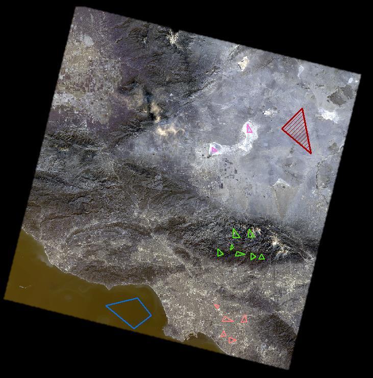
19
20 Algorithms All sorts of crazy maths
21 The Basic Equation Image Copyright (c) 2004 Kaustuv Chaudhuri
22 ISO Cluster I SO Love Clusters Unsupervised - Iterative Self Organizing - Initially, means are placed on a 45 degree line the multiband space and then each pixel is assigned to the closest mean. - New means are calculated. - The next iteration then assigns the pixels to the closest new mean. User selects number of classes and number of iterations Easy Not as accurate


23 Maximum Likelihood Supervised - Uses training sample variance and co-variance to create a multiband class signature. Assigns pixels to class based on the maximum likelihood of that they belong to that class - Assumes normal distribution of training data in multiband space

24 Support Vector Supervised - Similar to Maximum Likelihood - Places pixels in multiband space - Instead of determining the likelihood of a pixel belonging a class, pixels are assigned to classes so that the gaps between classes are as large as possible
25 Random Trees An Entmoot? Supervised - Creates decision trees for random sub-samples of the training data - Each pixel is then classified by each tree - The class that is most often selected by the trees is assigned to the pixel Band 7 > 0.4 Band 7 < 0.4 Band 4 > 0.3 Band 4 < 0.3 Water Soil Vegetation
26 Accuracy Assessment Assess the Accuracy

27 Accuracy Assessment Done to provide an idea of how well the Reclassification worked Real Values (Ground Truth/ Testing data) can be collected in the field or visually from Satellite Images 3 Main tools - Create Accuracy Assessment Points - Update Points - Create Confusion Matrix
28 Confusion Matrix Will you take the Red Cell or the Blue Cell? Generates a Kappa Index of Agreement between classified raster and ground truth data Index is based on how well the Classified Raster reflects the Ground Truth Points Kappa Index is expressed as a value between 0 and 1 - The closer to 1 the value is, the more accurate the reclassification was This tool is best used when comparing different Algorithms or Methods - This is because the Kappa Index assesses each raster independently GARBAGE IN, GARBAGE OUT
29 So, Why do We Do This?
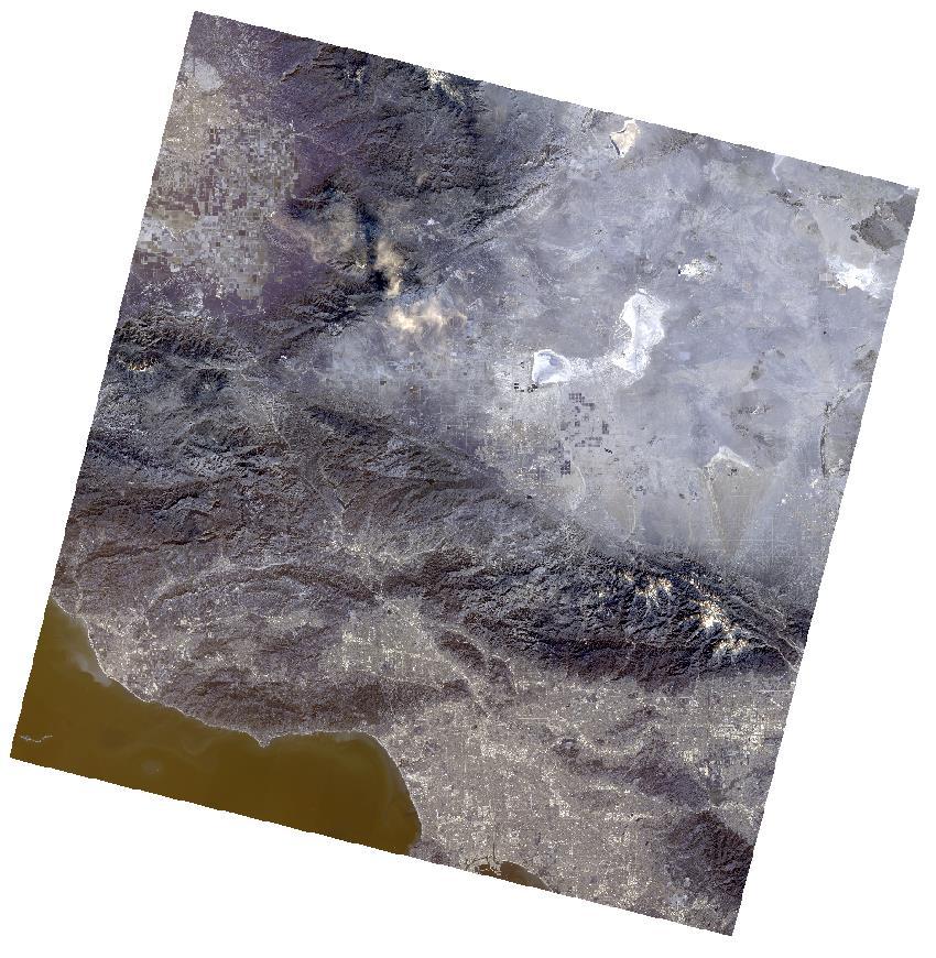
30 THIS

31 Becomes This
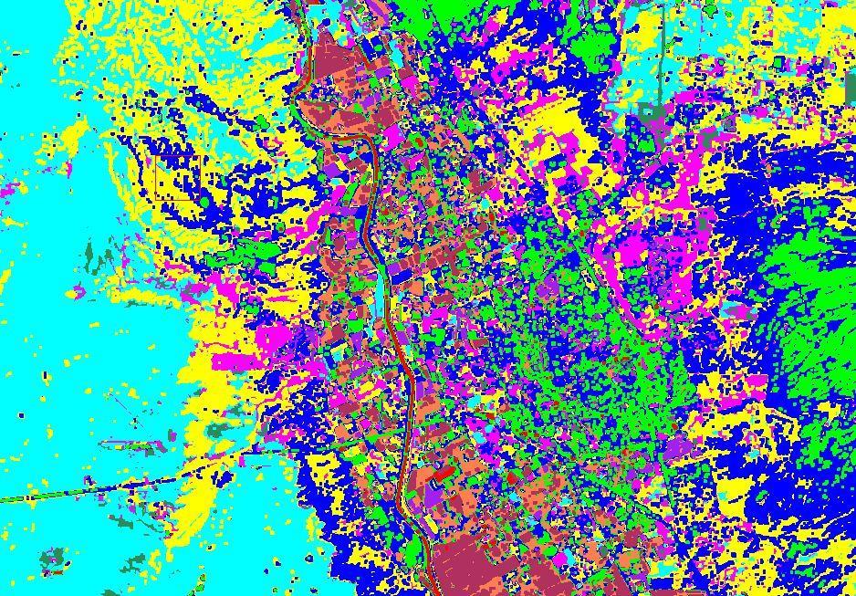

32


33
ArcGIS Pro: Image Segmentation, Classification, and Machine Learning. Jeff Liedtke and Han Hu
 ArcGIS Pro: Image Segmentation, Classification, and Machine Learning Jeff Liedtke and Han Hu Overview of Image Classification in ArcGIS Pro Overview of the classification workflow Classification tools
Lab 5: Image Analysis with ArcGIS 10 Unsupervised Classification
 Lab 5: Image Analysis with ArcGIS 10 Unsupervised Classification Peter E. Price TerraView 2010 Peter E. Price All rights reserved Revised 03/2011 Revised for Geob 373 by BK Feb 28, 2017. V3 The information
Lab 9. Julia Janicki. Introduction
 Lab 9 Julia Janicki Introduction My goal for this project is to map a general land cover in the area of Alexandria in Egypt using supervised classification, specifically the Maximum Likelihood and Support
Data: a collection of numbers or facts that require further processing before they are meaningful
 Digital Image Classification Data vs. Information Data: a collection of numbers or facts that require further processing before they are meaningful Information: Derived knowledge from raw data. Something
DIGITAL IMAGE ANALYSIS. Image Classification: Object-based Classification
 DIGITAL IMAGE ANALYSIS Image Classification: Object-based Classification Image classification Quantitative analysis used to automate the identification of features Spectral pattern recognition Unsupervised
Figure 1: Workflow of object-based classification
 Technical Specifications Object Analyst Object Analyst is an add-on package for Geomatica that provides tools for segmentation, classification, and feature extraction. Object Analyst includes an all-in-one
APPLICATION OF SOFTMAX REGRESSION AND ITS VALIDATION FOR SPECTRAL-BASED LAND COVER MAPPING
 APPLICATION OF SOFTMAX REGRESSION AND ITS VALIDATION FOR SPECTRAL-BASED LAND COVER MAPPING J. Wolfe a, X. Jin a, T. Bahr b, N. Holzer b, * a Harris Corporation, Broomfield, Colorado, U.S.A. (jwolfe05,
Digital Image Classification Geography 4354 Remote Sensing
 Digital Image Classification Geography 4354 Remote Sensing Lab 11 Dr. James Campbell December 10, 2001 Group #4 Mark Dougherty Paul Bartholomew Akisha Williams Dave Trible Seth McCoy Table of Contents:
Image Classification. RS Image Classification. Present by: Dr.Weerakaset Suanpaga
 Image Classification Present by: Dr.Weerakaset Suanpaga D.Eng(RS&GIS) 6.1 Concept of Classification Objectives of Classification Advantages of Multi-Spectral data for Classification Variation of Multi-Spectra
Introduction to digital image classification
 Introduction to digital image classification Dr. Norman Kerle, Wan Bakx MSc a.o. INTERNATIONAL INSTITUTE FOR GEO-INFORMATION SCIENCE AND EARTH OBSERVATION Purpose of lecture Main lecture topics Review
CHAPTER 5 OBJECT ORIENTED IMAGE ANALYSIS
 85 CHAPTER 5 OBJECT ORIENTED IMAGE ANALYSIS 5.1 GENERAL Urban feature mapping is one of the important component for the planning, managing and monitoring the rapid urbanized growth. The present conventional
Lab #4 Introduction to Image Processing II and Map Accuracy Assessment
 FOR 324 Natural Resources Information Systems Lab #4 Introduction to Image Processing II and Map Accuracy Assessment (Adapted from the Idrisi Tutorial, Introduction Image Processing Exercises, Exercise
Aerial photography: Principles. Visual interpretation of aerial imagery
 Aerial photography: Principles Visual interpretation of aerial imagery Overview Introduction Benefits of aerial imagery Image interpretation Elements Tasks Strategies Keys Accuracy assessment Benefits
THE USE OF VHR REMOTE SENSING IMAGERY FOR THE IDENTIFICATION OF ROOFS POTENTIALLY SUITABLE FOR THE INSTALLATION OF PHOTOVOLTAIC PANELS ORFEO PLEIADES
 THE USE OF VHR REMOTE SENSING IMAGERY FOR THE IDENTIFICATION OF ROOFS POTENTIALLY SUITABLE FOR THE INSTALLATION OF PHOTOVOLTAIC PANELS ORFEO PLEIADES December 8 th, 2010 OBJECTIVES Develop a method to
Classifying. Stuart Green Earthobservation.wordpress.com MERMS 12 - L4
 Classifying Stuart Green Earthobservation.wordpress.com Stuart.Green@Teagasc.ie MERMS 12 - L4 Classifying Replacing the digital numbers in each pixel (that tell us the average spectral properties of everything
Spectral Classification
 Spectral Classification Spectral Classification Supervised versus Unsupervised Classification n Unsupervised Classes are determined by the computer. Also referred to as clustering n Supervised Classes
Land Cover Classification Techniques
 Land Cover Classification Techniques supervised classification and random forests Developed by remote sensing specialists at the USFS Geospatial Technology and Applications Center (GTAC), located in Salt
Nearest Clustering Algorithm for Satellite Image Classification in Remote Sensing Applications
 Nearest Clustering Algorithm for Satellite Image Classification in Remote Sensing Applications Anil K Goswami 1, Swati Sharma 2, Praveen Kumar 3 1 DRDO, New Delhi, India 2 PDM College of Engineering for
Using Imagery for Intelligence Analysis
 2013 Esri International User Conference July 8 12, 2013 San Diego, California Technical Workshop Using Imagery for Intelligence Analysis Renee Bernstein Natalie Campos Esri UC2013. Technical Workshop.
Classification. Vladimir Curic. Centre for Image Analysis Swedish University of Agricultural Sciences Uppsala University
 Classification Vladimir Curic Centre for Image Analysis Swedish University of Agricultural Sciences Uppsala University Outline An overview on classification Basics of classification How to choose appropriate
Object Based Image Analysis: Introduction to ecognition
 Object Based Image Analysis: Introduction to ecognition ecognition Developer 9.0 Description: We will be using ecognition and a simple image to introduce students to the concepts of Object Based Image
Using ArcGIS for Landcover Classification. Presented by CORE GIS May 8, 2012
 Using ArcGIS for Landcover Classification Presented by CORE GIS May 8, 2012 How to use ArcGIS for Image Classification 1. Find and download the right data 2. Have a look at the data (true color/false color)
ENVI. Get the Information You Need from Imagery.
 Visual Information Solutions ENVI. Get the Information You Need from Imagery. ENVI is the premier software solution to quickly, easily, and accurately extract information from geospatial imagery. Easy
Case-Based Reasoning. CS 188: Artificial Intelligence Fall Nearest-Neighbor Classification. Parametric / Non-parametric.
 CS 188: Artificial Intelligence Fall 2008 Lecture 25: Kernels and Clustering 12/2/2008 Dan Klein UC Berkeley Case-Based Reasoning Similarity for classification Case-based reasoning Predict an instance
CS 188: Artificial Intelligence Fall 2008
 CS 188: Artificial Intelligence Fall 2008 Lecture 25: Kernels and Clustering 12/2/2008 Dan Klein UC Berkeley 1 1 Case-Based Reasoning Similarity for classification Case-based reasoning Predict an instance
GEOBIA for ArcGIS (presentation) Jacek Urbanski
 Jacek Urbanski") GEOBIA for ArcGIS (presentation) Jacek Urbanski INTEGRATION OF GEOBIA WITH GIS FOR SEMI-AUTOMATIC LAND COVER MAPPING FROM LANDSAT 8 IMAGERY Presented at 5th GEOBIA conference 21 24 May in Thessaloniki.
GEOBIA for ArcGIS (presentation) Jacek Urbanski INTEGRATION OF GEOBIA WITH GIS FOR SEMI-AUTOMATIC LAND COVER MAPPING FROM LANDSAT 8 IMAGERY Presented at 5th GEOBIA conference 21 24 May in Thessaloniki.
Classify Multi-Spectral Data Classify Geologic Terrains on Venus Apply Multi-Variate Statistics
 Classify Multi-Spectral Data Classify Geologic Terrains on Venus Apply Multi-Variate Statistics Operations What Do I Need? Classify Merge Combine Cross Scan Score Warp Respace Cover Subscene Rotate Translators
Aardobservatie en Data-analyse Image processing
 Aardobservatie en Data-analyse Image processing 1 Image processing: Processing of digital images aiming at: - image correction (geometry, dropped lines, etc) - image calibration: DN into radiance or into
EVALUATION OF CONVENTIONAL DIGITAL CAMERA SCENES FOR THEMATIC INFORMATION EXTRACTION ABSTRACT
 EVALUATION OF CONVENTIONAL DIGITAL CAMERA SCENES FOR THEMATIC INFORMATION EXTRACTION H. S. Lim, M. Z. MatJafri and K. Abdullah School of Physics Universiti Sains Malaysia, 11800 Penang ABSTRACT A study
The Feature Analyst Extension for ERDAS IMAGINE
 The Feature Analyst Extension for ERDAS IMAGINE Automated Feature Extraction Software for GIS Database Maintenance We put the information in GIS SM A Visual Learning Systems, Inc. White Paper September
Remote Sensed Image Classification based on Spatial and Spectral Features using SVM
 RESEARCH ARTICLE OPEN ACCESS Remote Sensed Image Classification based on Spatial and Spectral Features using SVM Mary Jasmine. E PG Scholar Department of Computer Science and Engineering, University College
(Refer Slide Time: 0:51)
") Introduction to Remote Sensing Dr. Arun K Saraf Department of Earth Sciences Indian Institute of Technology Roorkee Lecture 16 Image Classification Techniques Hello everyone welcome to 16th lecture in
Introduction to Remote Sensing Dr. Arun K Saraf Department of Earth Sciences Indian Institute of Technology Roorkee Lecture 16 Image Classification Techniques Hello everyone welcome to 16th lecture in
Automatic Segmentation of Semantic Classes in Raster Map Images
 Automatic Segmentation of Semantic Classes in Raster Map Images Thomas C. Henderson, Trevor Linton, Sergey Potupchik and Andrei Ostanin School of Computing, University of Utah, Salt Lake City, UT 84112
COMBINING HIGH SPATIAL RESOLUTION OPTICAL AND LIDAR DATA FOR OBJECT-BASED IMAGE CLASSIFICATION
 COMBINING HIGH SPATIAL RESOLUTION OPTICAL AND LIDAR DATA FOR OBJECT-BASED IMAGE CLASSIFICATION Ruonan Li 1, Tianyi Zhang 1, Ruozheng Geng 1, Leiguang Wang 2, * 1 School of Forestry, Southwest Forestry
Hybrid Model with Super Resolution and Decision Boundary Feature Extraction and Rule based Classification of High Resolution Data
 Hybrid Model with Super Resolution and Decision Boundary Feature Extraction and Rule based Classification of High Resolution Data Navjeet Kaur M.Tech Research Scholar Sri Guru Granth Sahib World University
RASTER ANALYSIS GIS Analysis Fall 2013
 RASTER ANALYSIS GIS Analysis Fall 2013 Raster Data The Basics Raster Data Format Matrix of cells (pixels) organized into rows and columns (grid); each cell contains a value representing information. What
Submerged Aquatic Vegetation Mapping using Object-Based Image Analysis with Lidar and RGB Imagery
 Submerged Aquatic Vegetation Mapping using Object-Based Image Analysis with Lidar and RGB Imagery Victoria Price Version 1, April 16 2015 Submerged Aquatic Vegetation Mapping using Object-Based Image Analysis
The Gain setting for Landsat 7 (High or Low Gain) depends on: Sensor Calibration - Application. the surface cover types of the earth and the sun angle
 depends on: Sensor Calibration - Application. the surface cover types of the earth and the sun angle") Sensor Calibration - Application Station Identifier ASN Scene Center atitude 34.840 (34 3'0.64"N) Day Night DAY Scene Center ongitude 33.03270 (33 0'7.72"E) WRS Path WRS Row 76 036 Corner Upper eft atitude
Sensor Calibration - Application Station Identifier ASN Scene Center atitude 34.840 (34 3'0.64"N) Day Night DAY Scene Center ongitude 33.03270 (33 0'7.72"E) WRS Path WRS Row 76 036 Corner Upper eft atitude
Classification. Vladimir Curic. Centre for Image Analysis Swedish University of Agricultural Sciences Uppsala University
 Classification Vladimir Curic Centre for Image Analysis Swedish University of Agricultural Sciences Uppsala University Outline An overview on classification Basics of classification How to choose appropriate
This is the general guide for landuse mapping using mid-resolution remote sensing data
 This is the general guide for landuse mapping using mid-resolution remote sensing data February 11 2015 This document has been prepared for Training workshop on REDD+ Research Project in Peninsular Malaysia
SYNERGY BETWEEN AERIAL IMAGERY AND LOW DENSITY POINT CLOUD FOR AUTOMATED IMAGE CLASSIFICATION AND POINT CLOUD DENSIFICATION
 SYNERGY BETWEEN AERIAL IMAGERY AND LOW DENSITY POINT CLOUD FOR AUTOMATED IMAGE CLASSIFICATION AND POINT CLOUD DENSIFICATION Hani Mohammed Badawy a,*, Adel Moussa a,b, Naser El-Sheimy a a Dept. of Geomatics
CSSE463: Image Recognition Day 21
 CSSE463: Image Recognition Day 21 Sunset detector due. Foundations of Image Recognition completed This wee: K-means: a method of Image segmentation Questions? An image to segment Segmentation The process
Gene Clustering & Classification
 BINF, Introduction to Computational Biology Gene Clustering & Classification Young-Rae Cho Associate Professor Department of Computer Science Baylor University Overview Introduction to Gene Clustering
EVALUATION OF THE THEMATIC INFORMATION CONTENT OF THE ASTER-VNIR IMAGERY IN URBAN AREAS BY CLASSIFICATION TECHNIQUES
 EVALUATION OF THE THEMATIC INFORMATION CONTENT OF THE ASTER-VNIR IMAGERY IN URBAN AREAS BY CLASSIFICATION TECHNIQUES T. G. Panagou a *, G. Ch. Miliaresis a a TEI, Dpt. of Topography, 3 P.Drakou Str., Thiva,
CPSC 425: Computer Vision
 1 / 31 CPSC 425: Computer Vision Instructor: Jim Little little@cs.ubc.ca Department of Computer Science University of British Columbia Lecture Notes 2016/2017 Term 2 2 / 31 Menu March 16, 2017 Topics:
COSC160: Detection and Classification. Jeremy Bolton, PhD Assistant Teaching Professor
 COSC160: Detection and Classification Jeremy Bolton, PhD Assistant Teaching Professor Outline I. Problem I. Strategies II. Features for training III. Using spatial information? IV. Reducing dimensionality
INCREASING CLASSIFICATION QUALITY BY USING FUZZY LOGIC
 JOURNAL OF APPLIED ENGINEERING SCIENCES VOL. 1(14), issue 4_2011 ISSN 2247-3769 ISSN-L 2247-3769 (Print) / e-issn:2284-7197 INCREASING CLASSIFICATION QUALITY BY USING FUZZY LOGIC DROJ Gabriela, University
TerraScan New Features
 www.terrasolid.com TerraScan New Features Arttu Soininen 23.01.2018 Import Scanner Positions for Trajectories File / Import scanner positions menu command in Manage Trajectories reads scanner positions
Keywords: impervious surface mapping; multi-temporal data; change detection; high-resolution imagery; LiDAR; object-based post-classification fusion
 Article An Improved Method for Impervious Surface Mapping Incorporating Lidar Data and High- Resolution Imagery at Different Acquisition Times Hui Luo 1,2, Le Wang 3, *, Chen Wu 4, and Lei Zhang 5 1 School
Classification (or thematic) accuracy assessment. Lecture 8 March 11, 2005
 accuracy assessment. Lecture 8 March 11, 2005") Classification (or thematic) accuracy assessment Lecture 8 March 11, 2005 Why and how Remote sensing-derived thematic information are becoming increasingly important. Unfortunately, they contain errors.
Classification (or thematic) accuracy assessment Lecture 8 March 11, 2005 Why and how Remote sensing-derived thematic information are becoming increasingly important. Unfortunately, they contain errors.
GST 105: Introduction to Remote Sensing Lab 6: Supervised Classification
 GST 105: Introduction to Remote Sensing Lab 6: Supervised Classification Objective Perform a Supervised classification Document Version: 2014-08-08 (Beta) Author: Richard : Smith, Ph.D. Texas A&M University
RASTER ANALYSIS S H A W N L. P E N M A N E A R T H D A T A A N A LY S I S C E N T E R U N I V E R S I T Y O F N E W M E X I C O
 RASTER ANALYSIS S H A W N L. P E N M A N E A R T H D A T A A N A LY S I S C E N T E R U N I V E R S I T Y O F N E W M E X I C O TOPICS COVERED Spatial Analyst basics Raster / Vector conversion Raster data
Monterey, CA, USA ABSTRACT 1. INTRODUCTION. phone ; fax ; nps.edu/rsc
 Application of image classification techniques to multispectral lidar point cloud data Chad I. Miller* a,b, Judson J. Thomas b, Angela M. Kim b, Jeremy P. Metcalf b, Richard C. Olsen b b SAIC, 1710 SAIC
Object-Based Classification & ecognition. Zutao Ouyang 11/17/2015
 Object-Based Classification & ecognition Zutao Ouyang 11/17/2015 What is Object-Based Classification The object based image analysis approach delineates segments of homogeneous image areas (i.e., objects)
Land managers need increased temporal and spatial
 Society for Range Management Image Interpreter Tool: An ArcGIS Tool for Estimating Vegetation Cover From High-Resolution Imagery By T. Scott Schrader and Michael C. Duniway Land managers need increased
Obtaining Submerged Aquatic Vegetation Coverage from Satellite Imagery and Confusion Matrix Analysis
 Obtaining Submerged Aquatic Vegetation Coverage from Satellite Imagery and Confusion Matrix Analysis Brian Madore April 7, 2015 This document shows the procedure for obtaining a submerged aquatic vegetation
RASTER ANALYSIS GIS Analysis Winter 2016
 RASTER ANALYSIS GIS Analysis Winter 2016 Raster Data The Basics Raster Data Format Matrix of cells (pixels) organized into rows and columns (grid); each cell contains a value representing information.
Lecture 11: Classification
 Lecture 11: Classification 1 2009-04-28 Patrik Malm Centre for Image Analysis Swedish University of Agricultural Sciences Uppsala University 2 Reading instructions Chapters for this lecture 12.1 12.2 in
Region-based Segmentation
 Region-based Segmentation Image Segmentation Group similar components (such as, pixels in an image, image frames in a video) to obtain a compact representation. Applications: Finding tumors, veins, etc.
IMAGINE Objective. The Future of Feature Extraction, Update & Change Mapping
 IMAGINE ive The Future of Feature Extraction, Update & Change Mapping IMAGINE ive provides object based multi-scale image classification and feature extraction capabilities to reliably build and maintain
An Approach To Classify The Object From The Satellite Image Using Image Analysis Tool
 IJIRST International Journal for Innovative Research in Science & Technology Volume 1 Issue 4 September 2014 ISSN(online) : 2349-6010 An Approach To Classify The Object From The Satellite Image Using Image
Open Multispec, and open an image for classification. -Selecting Training Fields:
 Supervised Classification [Software to use: Multispec] We will do a supervised classification by selecting training areas for specified classes from known areas. Open Multispec, and open an image for classification.
Remote Sensing Image Analysis via a Texture Classification Neural Network
 Remote Sensing Image Analysis via a Texture Classification Neural Network Hayit K. Greenspan and Rodney Goodman Department of Electrical Engineering California Institute of Technology, 116-81 Pasadena,
Remote Sensing Introduction to the course
 Remote Sensing Introduction to the course Remote Sensing (Prof. L. Biagi) Exploitation of remotely assessed data for information retrieval Data: Digital images of the Earth, obtained by sensors recording
A Vector Agent-Based Unsupervised Image Classification for High Spatial Resolution Satellite Imagery
 A Vector Agent-Based Unsupervised Image Classification for High Spatial Resolution Satellite Imagery K. Borna 1, A. B. Moore 2, P. Sirguey 3 School of Surveying University of Otago PO Box 56, Dunedin,
A Comparative Study of Conventional and Neural Network Classification of Multispectral Data
 A Comparative Study of Conventional and Neural Network Classification of Multispectral Data B.Solaiman & M.C.Mouchot Ecole Nationale Supérieure des Télécommunications de Bretagne B.P. 832, 29285 BREST
The Raster Data Model
 The Raster Data Model 2 2 2 2 8 8 2 2 8 8 2 2 2 2 2 2 8 8 2 2 2 2 2 2 2 2 2 Llano River, Mason Co., TX 1 Rasters are: Regular square tessellations Matrices of values distributed among equal-sized, square
Analysis of LIDAR Data Fused with Co-Registered Bands
 Analysis of LIDAR Data Fused with Co-Registered Bands Marc Bartels, Hong Wei and James Ferryman Computational Vision Group, School of Systems Engineering The University of Reading Whiteknights, Reading,
CLASSIFICATION OF ROOF MATERIALS USING HYPERSPECTRAL DATA
 CLASSIFICATION OF ROOF MATERIALS USING HYPERSPECTRAL DATA C. Chisense Department of Geomatics, Computer Science and Mathematics, University of Applied Sciences Stuttgart Schellingstraße 24, D-70174 Stuttgart
LORI COLLINS, RESEARCH ASSOCIATE PROFESSOR CONTRIBUTIONS BY: RICHARD MCKENZIE AND GARRETT SPEED, DHHC USF L IBRARIES
 LORI COLLINS, RESEARCH ASSOCIATE PROFESSOR CONTRIBUTIONS BY: RICHARD MCKENZIE AND GARRETT SPEED, DHHC USF L IBRARIES AERIAL AND TERRESTRIAL SURVEY WORKFLOWS Workflow from project planning applications
PARALLEL CLASSIFICATION ALGORITHMS
 PARALLEL CLASSIFICATION ALGORITHMS By: Faiz Quraishi Riti Sharma 9 th May, 2013 OVERVIEW Introduction Types of Classification Linear Classification Support Vector Machines Parallel SVM Approach Decision
Exelis Visual Information Solutions Capability Overview Presented to NetHope October 8, Brian Farr Academic & NGO Program Manager
 Exelis Visual Information Solutions Capability Overview Presented to NetHope October 8, 2013 Brian Farr Academic & NGO Program Manager Agenda Overview of ENVI Platform ENVI+IDL ENVI EX ENVI LiDAR Integration
INTEGRATION OF TREE DATABASE DERIVED FROM SATELLITE IMAGERY AND LIDAR POINT CLOUD DATA
 INTEGRATION OF TREE DATABASE DERIVED FROM SATELLITE IMAGERY AND LIDAR POINT CLOUD DATA S. C. Liew 1, X. Huang 1, E. S. Lin 2, C. Shi 1, A. T. K. Yee 2, A. Tandon 2 1 Centre for Remote Imaging, Sensing
Clustering Color/Intensity. Group together pixels of similar color/intensity.
 Clustering Color/Intensity Group together pixels of similar color/intensity. Agglomerative Clustering Cluster = connected pixels with similar color. Optimal decomposition may be hard. For example, find
Raster Data Models 9/18/2018
 Raster Data Models The Raster Data Model Rasters are: Regular square tessellations Matrices of values distributed among equal-sized, square cells 5 5 5 5 5 5 5 5 2 2 5 5 5 5 5 5 2 2 2 2 5 5 5 5 5 2 2 2
Files Used in This Tutorial. Background. Feature Extraction with Example-Based Classification Tutorial
 Feature Extraction with Example-Based Classification Tutorial In this tutorial, you will use Feature Extraction to extract rooftops from a multispectral QuickBird scene of a residential area in Boulder,
Three Dimensional Texture Computation of Gray Level Co-occurrence Tensor in Hyperspectral Image Cubes
 Three Dimensional Texture Computation of Gray Level Co-occurrence Tensor in Hyperspectral Image Cubes Jhe-Syuan Lai 1 and Fuan Tsai 2 Center for Space and Remote Sensing Research and Department of Civil
GST 105: Introduction to Remote Sensing Lab 5: Unsupervised Classification
 GST 105: Introduction to Remote Sensing Lab 5: Unsupervised Classification Objective Perform an unsupervised classification Document Version: 2014-07-15 (Beta) Author: Richard : Smith, Ph.D. Texas A&M
About the Land Image Analyst project Land Image Analyst was developed by GDA Corp for the USDA Forest Service Chesapeake Bay Program as a land cover
 About the Land Image Analyst project Land Image Analyst was developed by GDA Corp for the USDA Forest Service Chesapeake Bay Program as a land cover recognition tool to aid communities in developing land
Rasters are: The Raster Data Model. Cell location specified by: Why squares? Raster Data Models 9/25/2014. GEO327G/386G, UT Austin 1
 5 5 5 5 5 5 5 5 5 5 5 5 2 2 5 5 2 2 2 2 2 2 8 8 2 2 5 5 5 5 5 5 2 2 2 2 5 5 5 5 5 2 2 2 5 5 5 5 The Raster Data Model Rasters are: Regular square tessellations Matrices of values distributed among equalsized,
The Raster Data Model
 The Raster Data Model 2 2 2 2 8 8 2 2 8 8 2 2 2 2 2 2 8 8 2 2 2 2 2 2 2 2 2 Llano River, Mason Co., TX 9/24/201 GEO327G/386G, UT Austin 1 Rasters are: Regular square tessellations Matrices of values distributed
RESEARCH ON THE VISUALIZATION SYSTEM AND APPLICATIONS OF UNCERTAINTY IN REMOTE SENSING DATA CLASSIFICATION
 RESEARCH ON THE VISUALIZATION SYSTEM AND APPLICATIONS OF UNCERTAINTY IN REMOTE SENSING DATA CLASSIFICATION YanLiu a, Yanchen Bo b a National Geomatics Center of China, no1. Baishengcun,Zhizhuyuan, Haidian
MultiSpec Tutorial: Unsupervised Classification (Cluster Analysis)
") MultiSpec Tutorial: Unsupervised Classification (Cluster Analysis) Requirements: MultiSpec application and image titled ag020522_dpac_cd.lan. Two Clustering algorithms are available in MultiSpec. They
MultiSpec Tutorial: Unsupervised Classification (Cluster Analysis) Requirements: MultiSpec application and image titled ag020522_dpac_cd.lan. Two Clustering algorithms are available in MultiSpec. They
Fusion of pixel based and object based features for classification of urban hyperspectral remote sensing data
 Fusion of pixel based and object based features for classification of urban hyperspectral remote sensing data Wenzhi liao a, *, Frieke Van Coillie b, Flore Devriendt b, Sidharta Gautama a, Aleksandra Pizurica
v Importing Rasters SMS 11.2 Tutorial Requirements Raster Module Map Module Mesh Module Time minutes Prerequisites Overview Tutorial
 v. 11.2 SMS 11.2 Tutorial Objectives This tutorial teaches how to import a Raster, view elevations at individual points, change display options for multiple views of the data, show the 2D profile plots,
By Colin Childs, ESRI Education Services. Catalog
 s resolve many traditional raster management issues By Colin Childs, ESRI Education Services Source images ArcGIS 10 introduces Catalog Mosaicked images Sources, mosaic methods, and functions are used
Big Data Analytics! Special Topics for Computer Science CSE CSE Feb 9
 Big Data Analytics! Special Topics for Computer Science CSE 4095-001 CSE 5095-005! Feb 9 Fei Wang Associate Professor Department of Computer Science and Engineering fei_wang@uconn.edu Clustering I What
Dirty REMOTE SENSING : OBIA
 Dirt REMOTE SENSING : OBIA Stuart Green Teagasc Spatial Analsis Group Stuart.green@teagasc.ie Web for the Week: http://electronics.howstuffworks.com/gps.htm http://www.cstars.ucdavis.edu/classes/ers186-w03/lecture17/lecture17.ppt
Introduction to Remote Sensing
 Introduction to Remote Sensing Objective: The objective of this tutorial is to show you 1) how to create NDVI images to map the amount of green vegetation in an area 2) how to conduct a supervised classification
Attribute Accuracy. Quantitative accuracy refers to the level of bias in estimating the values assigned such as estimated values of ph in a soil map.
 Attribute Accuracy Objectives (Entry) This basic concept of attribute accuracy has been introduced in the unit of quality and coverage. This unit will teach a basic technique to quantify the attribute
Automated Extraction of Buildings from Aerial LiDAR Point Cloud and Digital Imaging Datasets for 3D Cadastre - Preliminary Results
 Automated Extraction of Buildings from Aerial LiDAR Point Cloud and Digital Imaging Datasets for 3D Pankaj Kumar 1*, Alias Abdul Rahman 1 and Gurcan Buyuksalih 2 ¹Department of Geoinformation Universiti
Extracting Layers and Recognizing Features for Automatic Map Understanding. Yao-Yi Chiang
 Extracting Layers and Recognizing Features for Automatic Map Understanding Yao-Yi Chiang 0 Outline Introduction/ Problem Motivation Map Processing Overview Map Decomposition Feature Recognition Discussion
A NEW APPROACH TO OBJECT RECOGNITION ON HIGH RESOLUTION SATELLITE IMAGE *
 A NEW APPROACH TO OBJECT RECOGNITION ON HIGH RESOLUTION SATELLITE IMAGE Qiming QIN,Yinhuan YUAN, Rongjian LU Peking University, P.R China,100871 Institute of Remote Sensing and Geographic Information System
More on Learning. Neural Nets Support Vectors Machines Unsupervised Learning (Clustering) K-Means Expectation-Maximization
 K-Means Expectation-Maximization") More on Learning Neural Nets Support Vectors Machines Unsupervised Learning (Clustering) K-Means Expectation-Maximization Neural Net Learning Motivated by studies of the brain. A network of artificial
More on Learning Neural Nets Support Vectors Machines Unsupervised Learning (Clustering) K-Means Expectation-Maximization Neural Net Learning Motivated by studies of the brain. A network of artificial
Machine Learning Applications in Exploration and Mining
 Machine Learning Applications in Exploration and Mining Tom Carmichael, Brenton Crawford, Liam Webb. QEC - The role of data in discovery 28 th February 2018 www.solvegeosolutions.com Outline Where and
HIERARCHICAL CLASSIFICATION OF POLARIMETRIC SAR IMAGE BASED ON STATISTICAL REGION MERGING
 HIERARCHICAL CLASSIFICATION OF POLARIMETRIC SAR IMAGE BASED ON STATISTICAL REGION MERGING F. Lang a*, J. Yang a, L. Zhao a, D. Li a a State Key Laboratory of Information Engineering in Surveying, Mapping
GIS-Generated Street Tree Inventory Pilot Study
 GIS-Generated Street Tree Inventory Pilot Study Prepared for: MSGIC Meeting Prepared by: Beth Schrayshuen, PE Marla Johnson, GISP 21 July 2017 Agenda 2 Purpose of Street Tree Inventory Pilot Study Evaluation
NRM435 Spring 2017 Accuracy Assessment of GIS Data
 Accuracy Assessment Lab Page 1 of 18 NRM435 Spring 2017 Accuracy Assessment of GIS Data GIS data always contains errors hopefully the errors are so small that will do not significantly affect the results
The Reference Library Generating Low Confidence Polygons
 GeoCue Support Team In the new ASPRS Positional Accuracy Standards for Digital Geospatial Data, low confidence areas within LIDAR data are defined to be where the bare earth model might not meet the overall
Georeferencing in ArcGIS
 Georeferencing in ArcGIS Georeferencing In order to position images on the surface of the earth, they need to be georeferenced. Images are georeferenced by linking unreferenced features in the image with