OCEANSAT-2 OCEAN COLOUR MONITOR (OCM-2)
|
|
|
- Rosalyn Cole
- 6 years ago
- Views:
Transcription
1 OCEANSAT-2 OCEAN COLOUR MONITOR (OCM-2) Update of post launch vicarious, lunar calibrations & current status Presented by Prakash Chauhan Space Applications Centre Indian Space Research Organistaion Ahmedabad- India


2 OCEANSAT-2 OCEAN COLOUR MONITOR (OCM-2)

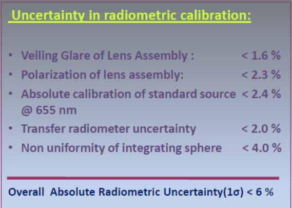
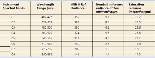
3 PRE-LAUNCH PERFORMANCE (Radiometric/Spatial)

4 MODES OF OPERATIONS Local Area Coverage (LAC) with 360m, real time transmission Global area coverage (GAC) with 1 km, on-board Recording & playback GAC data coverage between +/ Latitude covering full globe in 8 days

 at 865 nm Products supported in HDF 4 format can be Displayed and processed in")
5 OCEANSAT-2 OCM Data products LEVEL-1 Product: Basic Data Products - L1A RAW Products (Internal Use Only & DQE) - L1B Radiance Product - L1C Radiometrically and Geometrically corrected LEVEL-2 Product: Geo-Physical Parameters - Chlorophyll-a concentration - Total Suspended Matter (TSM) - Diffused Attenuation Coefficients (K d nm) - Aerosol Optical Depth (AOD) at 865 nm Products supported in HDF 4 format can be Displayed and processed in SeaDas


6 Absolute Radiometric Cal & Lunar Calibration of OCM -2 Three Moon acquisitions for OCM-2 were done , and 1 Aug 2012 ROLO Model OCM measured 26 July Nov 2011

; Under clear atmospheric conditions (AOD 870nm < 0.")
7 Vicarious Calibration of OCM -2 Vicarious calibration is considered as a tool for verifying the pre-launch calibration data evaluating possible sensor decay with ageing Cal/Val site at Kavaratii in Arabian sea In water sea reflectance data is being collected in low chlorophyll waters (<0.125 mg/m 3 ); Under clear atmospheric conditions (AOD 870nm < 0.2); using hyper spectral instruments; and well calibrated field instruments


8 Long Term ocean reflectance observations using Kavaratii buoy


9 Ocean & Atmospheric Parameter variability at KVT Time series observations of in-water parameters, Year 2012 Time series observation of AOD at 870nm, Year 2012
 B1-0.95 B2-1.02 B3-0.96 B4-0.98 B5-0.")
10 Vicarious Calibration Results ( ) Band No. Total points % error CC (R 2 ) Mean TOA radiance (µw/cm 2 /sr/nm) KVT OCM Gain coefficients (2013) B B B B B B B B8-0.80
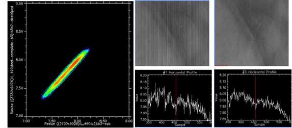

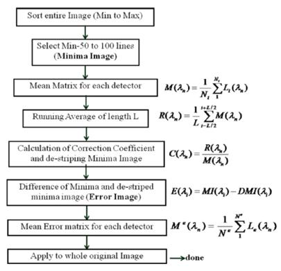
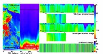
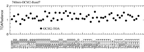
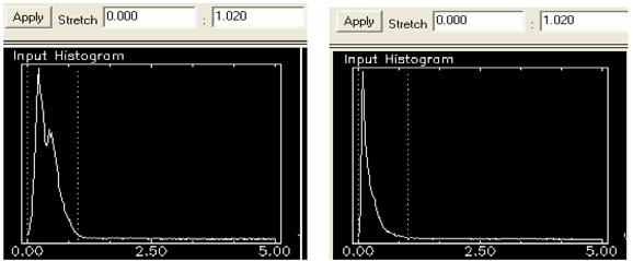
11 Relative radiometric calibration of OCM2 data Band -3 Algorithm details


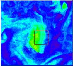
12 Retrieved Chl-a from OCM-2 and MODIS, 25 th September-2011 (After moon calibration of OCM-2) Oceansat-2, OCM MODIS India India mg/m^3

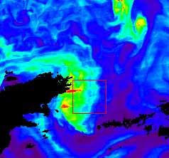
13 MODIS & OCM comparison II I III OCM-2 MODIS


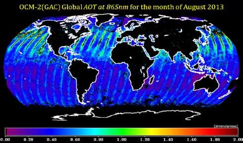
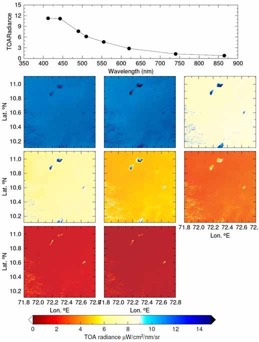
14 Global Monthly products from OCM-2
 aerosols : estimated using MODIS 865 nm band Only optical thickness < 0.1 are kept gain No.")
15 Rayleigh Calibration Observe the atmosphere over ocean (dark) Rayleigh scattering : > 80% of signal TOA reflectance well predicted using RT models Data Source s ocean surface reflectance : predicted using climatology derived from SeaWiFS only over very stable oceanic zones (oligotrophic zones) aerosols : estimated using MODIS 865 nm band Only optical thickness < 0.1 are kept gain No. of Pixels

")
 OCM R")
 OCM")
16 Rayleigh Calibration (Results) R rs (488) MODIS R rs (490) OCM R rs (555) MODIS R rs (555) OCM

17 15-16 March Chlorophyll-a
 5 4 3 0 1.")


18 3-4 March 2012 Rayleigh Calibration (Results) Chlorophyll-a Y=Chl-a OCM X=Chl-a MODIS Y=0.61X-0.25 R=0.82 RMSE= International Ocean Colour Science Meeting, San Francisco, June 15-18,

 N= 453166 S=0.")
19 OCM Rrs490 (January, 2014) N= S= I=0.003 RMSE=0.001 R=0.7 I N= S=0.62 I=0.004 RMSE= R=0.61 II MODIS Rrs490 (January, 2014) N= S=0.66 I= RMSE=0.001 R=0.54 III I II III
")
20 Reprocessed Global Chlorophyll-a distribution (January, 2012) Chlorophyll-a mg/m 3

21 Summary Post launch Lunar and Vicarious calibration techniques have been used to asses the radiometric cal of OCM-2 data Lunar calibration using ROLO model has improved the geophysical retrieval. Vicarious Calibration has helped in tracing the radiometric stability Relative radiometric calibration techniques have reduced striping Rayleigh calibration has helped further in overall improvement of global geophysical products KVT Cal/Val buoy data available from Thank You Validation at KVT site OCM-2 Chl In-situ Chl
Calibration Techniques for NASA s Remote Sensing Ocean Color Sensors
 Calibration Techniques for NASA s Remote Sensing Ocean Color Sensors Gerhard Meister, Gene Eplee, Bryan Franz, Sean Bailey, Chuck McClain NASA Code 614.2 Ocean Biology Processing Group October 21st, 2010
Menghua Wang NOAA/NESDIS/STAR Camp Springs, MD 20746, USA
 Ocean EDR Product Calibration and Validation Plan Progress Report: VIIRS Ocean Color Algorithm Evaluations and Data Processing and Analyses Define a VIIRS Proxy Data Stream Define the required in situ
Multi-sensors vicarious calibration activities at CNES
 Multi-sensors vicarious calibration activities at CNES Patrice Henry, Bertrand Fougnie June 11, 2013 CNES background in image quality monitoring of operational Earth observation systems Since the launch
The NIR- and SWIR-based On-orbit Vicarious Calibrations for VIIRS
 The NIR- and SWIR-based On-orbit Vicarious Calibrations for VIIRS Menghua Wang NOAA/NESDIS/STAR E/RA3, Room 3228, 5830 University Research Ct. College Park, MD 20746, USA Menghua.Wang@noaa.gov Workshop
Ocean Colour Vicarious Calibration Community requirements for future infrastructures
 Ocean Colour Vicarious Calibration Community requirements for future infrastructures IOCS 2017 - Breakout Workshop#3 IOCS 2017 ocean colour vicarious calibration 1 Part II: Discussion on community requirements
Atmospheric Correction and Vicarious Calibration of Oceansat-1 Ocean Color Monitor (OCM) Data in Coastal Case 2 Waters
 Data in Coastal Case 2 Waters") Remote Sens. 2012, 4, 1716-1740; doi:10.3390/rs4061716 Article OPEN ACCESS Remote Sensing ISSN 2072-4292 www.mdpi.com/journal/remotesensing Atmospheric Correction and Vicarious Calibration of Oceansat-1
Remote Sens. 2012, 4, 1716-1740; doi:10.3390/rs4061716 Article OPEN ACCESS Remote Sensing ISSN 2072-4292 www.mdpi.com/journal/remotesensing Atmospheric Correction and Vicarious Calibration of Oceansat-1
Improved Global Ocean Color using POLYMER Algorithm
 Improved Global Ocean Color using POLYMER Algorithm François Steinmetz 1 Didier Ramon 1 Pierre-Yves Deschamps 1 Jacques Stum 2 1 Hygeos 2 CLS June 29, 2010 ESA Living Planet Symposium, Bergen, Norway c
Cross Calibration Of IRS-P4 OCM Satellite Sensor
 Cross Calibration Of IRS-P4 OCM Satellite Sensor T.Suresh, Elgar Desa, Antonio Mascarenhas, S.G. Prabhu Matondkar, Puneeta Naik, S.R.Nayak* National Institute of Oceanography, Goa 403004, India *Space
MERIS US Workshop. Vicarious Calibration Methods and Results. Steven Delwart
 MERIS US Workshop Vicarious Calibration Methods and Results Steven Delwart Presentation Overview Recent results 1. CNES methods Deserts, Sun Glint, Rayleigh Scattering 2. Inter-sensor Uyuni 3. MOBY-AAOT
Atmospheric correction of hyperspectral ocean color sensors: application to HICO
 Atmospheric correction of hyperspectral ocean color sensors: application to HICO Amir Ibrahim NASA GSFC / USRA Bryan Franz, Zia Ahmad, Kirk knobelspiesse (NASA GSFC), and Bo-Cai Gao (NRL) Remote sensing
Lab 13 SeaDAS Ocean color Processing
 Lab 13 SeaDAS Ocean color Processing 13. 1 Interactive SeaDAS Processing: MODIS The purpose of this exercise is to present an overview of the basic steps involved in processing the MODIS data that you
Ocean Products and Atmospheric Removal in APS
 Oregon State Ocean Products and Atmospheric Removal in APS David Lewis Oceanography Division Naval Research Laboratory Stennis Space Center, Mississipp david.lewis@nrlssc.navy.mil Contributors: David Lewis
Evaluation of Satellite Ocean Color Data Using SIMBADA Radiometers
 Evaluation of Satellite Ocean Color Data Using SIMBADA Radiometers Robert Frouin Scripps Institution of Oceanography, la Jolla, California OCR-VC Workshop, 21 October 2010, Ispra, Italy The SIMBADA Project
End-to-End Simulation of Sentinel-2 Data with Emphasis on Atmospheric Correction Methods
 End-to-End Simulation of Sentinel-2 Data with Emphasis on Atmospheric Correction Methods Luis Guanter 1, Karl Segl 2, Hermann Kaufmann 2 (1) Institute for Space Sciences, Freie Universität Berlin, Germany
Preliminary validation of Himawari-8/AHI navigation and calibration
 Preliminary validation of Himawari-8/AHI navigation and calibration Arata Okuyama 1, Akiyoshi Andou 1, Kenji Date 1, Nobutaka Mori 1, Hidehiko Murata 1, Tasuku Tabata 1, Masaya Takahashi 1, Ryoko Yoshino
CALIPSO Version 3 Data Products: Additions and Improvements
 CALIPSO Version 3 Data Products: Additions and Improvements Dave Winker and the CALIPSO team CALIPSO/CloudSat Science Team Meeting 28-31 July, Madison, WI 1 Version 3 Status Version 3 algorithms now used
Exercises with Level-2 satellite data
 Exercises with Level-2 satellite data Mati Kahru WimSoft, http://www.wimsoft.com Email: wim@wimsoft.com also at Scripps Institution of Oceanography UCSD, La Jolla, CA 92093-0218, USA mkahru@ucsd.edu 10/25/2008
K d (490) models characterisation Issue 1 revision 0 Gilbert Barrot, ACRI-ST 05/jul/2006
 models characterisation Issue 1 revision 0 Gilbert Barrot, ACRI-ST 05/jul/2006") K d (490) models characterisation Issue 1 revision 0 Gilbert Barrot, ACRI-ST 05/jul/2006 K d (490) is the diffuse attenuation coefficient at 490 nm. It is one indicator of the turbidity of the ater column.
K d (490) models characterisation Issue 1 revision 0 Gilbert Barrot, ACRI-ST 05/jul/2006 K d (490) is the diffuse attenuation coefficient at 490 nm. It is one indicator of the turbidity of the ater column.
Kohei Arai 1 1Graduate School of Science and Engineering Saga University Saga City, Japan. Kenta Azuma 2 2 Cannon Electronics Inc.
 Method for Surface Reflectance Estimation with MODIS by Means of Bi-Section between MODIS and Estimated Radiance as well as Atmospheric Correction with Skyradiometer Kohei Arai 1 1Graduate School of Science
BOUSSOLE DATA PROCESSING
 BOUSSOLE DATA PROCESSING D. Antoine, B. Gentili, E. Leymarie V. Vellucci OUTLINE OUTLINE > Preprocessing conversion to physical units dark subtraction data reduction > Processing conversion to physical
GOCI Post-launch calibration and GOCI-II Pre-launch calibration plan
 Breakout Session: Satellite Calibration, IOCS Meeting 2015, 18 June 2015. GOCI Post-launch calibration and GOCI-II Pre-launch calibration plan Seongick CHO Korea Ocean Satellite Center, Korea Institute
Develop proxy VIIRS Ocean Color remotesensing reflectance from MODIS
 Develop proxy VIIRS Ocean Color remotesensing reflectance from ODIS 1) Define a VIIRS Proxy Data Stream 2) Define the required in situ data stream for Cal/Val 3) Tuning of algorithms and LUTS (Vicarious
S2 MPC Data Quality Report Ref. S2-PDGS-MPC-DQR
 S2 MPC Data Quality Report Ref. S2-PDGS-MPC-DQR 2/13 Authors Table Name Company Responsibility Date Signature Written by S. Clerc & MPC Team ACRI/Argans Technical Manager 2015-11-30 Verified by O. Devignot
2017 Summer Course on Optical Oceanography and Ocean Color Remote Sensing. Introduction to Remote Sensing
 2017 Summer Course on Optical Oceanography and Ocean Color Remote Sensing Introduction to Remote Sensing Curtis Mobley Delivered at the Darling Marine Center, University of Maine July 2017 Copyright 2017
Uncertainties in ocean colour remote sensing
 ENMAP Summer School on Remote Sensing Data Analysis Uncertainties in ocean colour remote sensing Roland Doerffer Retired from Helmholtz Zentrum Geesthacht Institute of Coastal Research Now: Brockmann Consult
Update on S3 SYN-VGT algorithm status PROBA-V QWG 4 24/11/2016
 ACRI-ST S3MPC 2014-2016 Update on S3 SYN-VGT algorithm status PROBA-V QWG 4 24/11/2016 Agenda Continuity with PROBA-V data - Evolution of S3 SYN / Creation of an alternative Proba-V like processing chain
Improving remotely sensed fused ocean data products through crosssensor
 Improving remotely sensed fused ocean data products through crosssensor calibration Mark David Lewis Ruhul Amin Sonia Gallegos Richard W. Gould, Jr. Sherwin Ladner Adam Lawson Rong-rong Li Improving remotely
Sentinel-2 Calibration and Validation : from the Instrument to Level 2 Products
 Sentinel-2 Calibration and Validation : from the Instrument to Level 2 Products Vincent Lonjou a, Thierry Tremas a, Sophie Lachérade a, Cécile Dechoz a, Florie Languille a, Aimé Meygret a, Olivier Hagolle
SGLI & GLI data policy. Hiroshi Murakami JAXA/EORC Multi-Agency Data Sharing session
 SGLI & GLI data policy Hiroshi Murakami JAXA/EORC Multi-Agency Data Sharing session 1 1. GCOM-C1 data distribution 1. Svalbard downlink station Global observation data downlink including all the 250- m
Global and Regional Retrieval of Aerosol from MODIS
 Global and Regional Retrieval of Aerosol from MODIS Why study aerosols? CLIMATE VISIBILITY Presented to UMBC/NESDIS June 4, 24 Robert Levy, Lorraine Remer, Yoram Kaufman, Allen Chu, Russ Dickerson modis-atmos.gsfc.nasa.gov
Data Warehouse Phase 2 CORE Datasets Status 15 th December 2018
 Data Warehouse Phase 2 CORE Datasets Status 15 th December 2018 The document presents the status of the open CORE datasets, for which data provision is on-going. Once closed, content of the datasets can
Thermal And Near infrared Sensor for carbon Observation (TANSO) onboard the Greenhouse gases Observing SATellite (GOSAT) Research Announcement
 onboard the Greenhouse gases Observing SATellite (GOSAT) Research Announcement") Thermal And Near infrared Sensor for carbon Observation (TANSO) onboard the Greenhouse gases Observing SATellite (GOSAT) Research Announcement Appendix B GOSAT/TANSO Calibration and Validation Plan and
Thermal And Near infrared Sensor for carbon Observation (TANSO) onboard the Greenhouse gases Observing SATellite (GOSAT) Research Announcement Appendix B GOSAT/TANSO Calibration and Validation Plan and
Verification of MSI Low Radiance Calibration Over Coastal Waters, Using AERONET-OC Network
 Verification of MSI Low Radiance Calibration Over Coastal Waters, Using AERONET-OC Network Yves Govaerts and Marta Luffarelli Rayference Radiometric Calibration Workshop for European Missions ESRIN, 30-31
2017 Summer Course on Optical Oceanography and Ocean Color Remote Sensing. Apparent Optical Properties and the BRDF
 2017 Summer Course on Optical Oceanography and Ocean Color Remote Sensing Curtis Mobley Apparent Optical Properties and the BRDF Delivered at the Darling Marine Center, University of Maine July 2017 Copyright
Sentinel-2/Landsat-8 Characterization and Cross - Cal
 Sentinel-2/Landsat-8 Characterization and Cross - Cal Markham Support for analysis of MSI performance data; coordination of Cal Team; Pre-launch Cross calibrations Helder/Leigh Improved use of PICS sites
TOTAL SUSPENDED MATTER MAPS FROM CHRIS IMAGERY OF A SMALL INLAND WATER BODY IN OOSTENDE (BELGIUM)
") TOTAL SUSPENDED MATTER MAPS FROM IMAGERY OF A SMALL INLAND WATER BODY IN OOSTENDE (BELGIUM) Barbara Van Mol (1) and Kevin Ruddick (1) (1) Management Unit of the North Sea Mathematical Models (MUMM), Royal
TOTAL SUSPENDED MATTER MAPS FROM IMAGERY OF A SMALL INLAND WATER BODY IN OOSTENDE (BELGIUM) Barbara Van Mol (1) and Kevin Ruddick (1) (1) Management Unit of the North Sea Mathematical Models (MUMM), Royal
Uncertainties in the Products of Ocean-Colour Remote Sensing
 Chapter 3 Uncertainties in the Products of Ocean-Colour Remote Sensing Emmanuel Boss and Stephane Maritorena Data products retrieved from the inversion of in situ or remotely sensed oceancolour data are
CalVal needs for S2/S3 data normalisation
 CalVal needs for S2/S3 data normalisation Mission Performance Centre B. Alhammoud, with support of R. Serra & V. Vellucci presentation by FR Martin-Lauzer FRM4SOC,21-23 February 2017, ESRIN Goal: EO synergy
Exploring Techniques for Improving Retrievals of Bio-optical Properties of Coastal Waters
 DISTRIBUTION STATEMENT A. Approved for public release; distribution is unlimited. Exploring Techniques for Improving Retrievals of Bio-optical Properties of Coastal Waters Samir Ahmed Department of Electrical
Name Company Function Signature Date
 Page : i of 1 Title: MERMAID data format Doc. no: QWG-MER-MERMAID-DF-02 Issue: 2 Revision: 3 Date: 22/03/2012 Name Company Function Signature Date Prepared by: C. Mazeran ACRI-ST W.P. Manager 22/03/2012
CLEAR VISION ON TURBID WATER: THE NAIVASHA LAKE
 CLEAR VISION ON TURBID WATER: THE NAIVASHA LAKE M.S. Salama S.SALAMA@UTWNTE.NL June 13-14, 2013 Outlines Study Area The problem Objectives Field data Hydro optical models Empirical: CDOM, Chl-a and KD
Algorithm Theoretical Basis Document (ATBD) for Calibration of space sensors over Rayleigh Scattering : Initial version for LEO sensors
 for Calibration of space sensors over Rayleigh Scattering : Initial version for LEO sensors") 1 Algorithm Theoretical Basis Document (ATBD) for Calibration of space sensors over Rayleigh Scattering : Initial version for LEO sensors Bertrand Fougnie, Patrice Henry CNES 2 nd July, 2013 1. Introduction
1 Algorithm Theoretical Basis Document (ATBD) for Calibration of space sensors over Rayleigh Scattering : Initial version for LEO sensors Bertrand Fougnie, Patrice Henry CNES 2 nd July, 2013 1. Introduction
IOCS San Francisco 2015 Uncertainty algorithms for MERIS / OLCI case 2 water products
 IOCS San Francisco 2015 Uncertainty algorithms for MERIS / OLCI case 2 water products Roland Doerffer Brockmann Consult The problem of optically complex water high variability of optical properties of
Prototyping GOES-R Albedo Algorithm Based on MODIS Data Tao He a, Shunlin Liang a, Dongdong Wang a
 Prototyping GOES-R Albedo Algorithm Based on MODIS Data Tao He a, Shunlin Liang a, Dongdong Wang a a. Department of Geography, University of Maryland, College Park, USA Hongyi Wu b b. University of Electronic
CALIBRATION OF VEGETATION CAMERAS ON-BOARD SPOT4
 CALIBRATION OF VEGETATION CAMERAS ON-BOARD SPOT4 Patrice Henry, Aimé Meygret CNES (Centre National d'etudes Spatiales) 18 avenue Edouard Belin - 31401 TOULOUSE CEDEX 4 - FRANCE Tel: 33 (0)5 61 27 47 12,
SST Retrieval Methods in the ESA Climate Change Initiative
 ESA Climate Change Initiative Phase-II Sea Surface Temperature (SST) www.esa-sst-cci.org SST Retrieval Methods in the ESA Climate Change Initiative Owen Embury Climate Change Initiative ESA Climate Change
UAV-based Remote Sensing Payload Comprehensive Validation System
 36th CEOS Working Group on Calibration and Validation Plenary May 13-17, 2013 at Shanghai, China UAV-based Remote Sensing Payload Comprehensive Validation System Chuan-rong LI Project PI www.aoe.cas.cn
MODIS Land Bands for Ocean Remote Sensing Applications
 MODIS Land Bands for Ocean Remote Sensing Applications Bryan A. Franz,2, P. Jeremy Werdell,3, Gerhard Meister,4, Ewa J. Kwiatkowska,2, Sean W. Bailey,4, Ziauddin Ahmad,5, and Charles R. McClain NASA Goddard
Quality assessment of RS data. Remote Sensing (GRS-20306)
") Quality assessment of RS data Remote Sensing (GRS-20306) Quality assessment General definition for quality assessment (Wikipedia) includes evaluation, grading and measurement process to assess design,
Quality assessment of RS data Remote Sensing (GRS-20306) Quality assessment General definition for quality assessment (Wikipedia) includes evaluation, grading and measurement process to assess design,
GODDARD SPACE FLIGHT CENTER. Future of cal/val. K. Thome NASA/GSFC
 GODDARD SPACE FLIGHT CENTER Future of cal/val K. Thome NASA/GSFC Key issues for cal/val Importance of cal/val continues to increase as models improve and budget pressures go up Better cal/val approaches
CHRIS Proba Workshop 2005 II
 CHRIS Proba Workshop 25 Analyses of hyperspectral and directional data for agricultural monitoring using the canopy reflectance model SLC Progress in the Upper Rhine Valley and Baasdorf test-sites Dr.
GEOG 4110/5100 Advanced Remote Sensing Lecture 2
 GEOG 4110/5100 Advanced Remote Sensing Lecture 2 Data Quality Radiometric Distortion Radiometric Error Correction Relevant reading: Richards, sections 2.1 2.8; 2.10.1 2.10.3 Data Quality/Resolution Spatial
Supplement of Sea-surface dimethylsulfide (DMS) concentration from satellite data at global and regional scales
 concentration from satellite data at global and regional scales") Supplement of Biogeosciences, 15, 3497 3519, 2018 https://doi.org/10.5194/bg-15-3497-2018-supplement Author(s) 2018. This work is distributed under the Creative Commons Attribution 4.0 License. Supplement
Supplement of Biogeosciences, 15, 3497 3519, 2018 https://doi.org/10.5194/bg-15-3497-2018-supplement Author(s) 2018. This work is distributed under the Creative Commons Attribution 4.0 License. Supplement
CHRIS PROBA instrument
 CHRIS PROBA instrument Wout Verhoef ITC, The Netherlands verhoef @itc.nl 29 June 2009, D1L5 Contents Satellite and instrument Images Multi-angular analysis Toolbox CHRIS-PROBA PROBA-CHRIS Project for On-Board
Exercises with Level-2 satellite data
 Exercises with Level-2 satellite data Mati Kahru WimSoft, http://www.wimsoft.com Email: wim@wimsoft.com & Scripps Institution of Oceanography UCSD, La Jolla, CA 92093-0218, USA mkahru@ucsd.edu 24-Jan-15
OCEAN COLOUR PRODUCTION CENTRE Ocean Colour Mediterranean and Black Sea Observation Product
 OCEAN COLOUR PRODUCTION CENTRE Black Sea Observation Product OCEANCOLOUR_MED_OPTICS_L3_NRT_OBSERVATIONS_009_038 OCEANCOLOUR_MED_OPTICS_L4_NRT_OBSERVATIONS_009_039 OCEANCOLOUR_MED_OPTICS_L3_REP_OBSERVATIONS_009_095
UV Remote Sensing of Volcanic Ash
 UV Remote Sensing of Volcanic Ash Kai Yang University of Maryland College Park WMO Inter-comparison of Satellite-based Volcanic Ash Retrieval Algorithms Workshop June 26 July 2, 2015, Madison, Wisconsin
Sentinel-3 OLCI: Status
 Sentinel-3 OLCI: Status Jens Nieke, F. Borde, C. Mavrocordatos OLCI Status 26 Nov 2013 ESRIN 1 Outline Background OLCI development status Assembly, Testing & Integration (AIT) Camera EM and FM test results
Kohei Arai 1 Graduate School of Science and Engineering Saga University Saga City, Japan
 Sensitivity Analysis and Error Analysis of Reflectance Based Vicarious Calibration with Estimated Aerosol Refractive Index and Size Distribution Derived from Measured Solar Direct and Diffuse Irradiance
IOCCG Calibration Workshop 30 October 2004, Fremantle, Australia. In-Flight Calibration of Satellite Ocean-Color Sensors
 IOCCG Calibration Workshop 30 October 2004, Fremantle, Australia In-Flight Calibration of Satellite Ocean-Color Sensors Purpose The purpose of the workshop was to review the calibration of ocean-color
Reprocessing of Suomi NPP CrIS SDR and Impacts on Radiometric and Spectral Long-term Accuracy and Stability
 Reprocessing of Suomi NPP CrIS SDR and Impacts on Radiometric and Spectral Long-term Accuracy and Stability Yong Chen *1, Likun Wang 1, Denis Tremblay 2, and Changyong Cao 3 1.* University of Maryland,
Update on Pre-Cursor Calibration Analysis of Sentinel 2. Dennis Helder Nischal Mishra Larry Leigh Dave Aaron
 Update on Pre-Cursor Calibration Analysis of Sentinel 2 Dennis Helder Nischal Mishra Larry Leigh Dave Aaron Background The value of Sentinel-2 data, to the Landsat world, will be entirely dependent on
A Method Suitable for Vicarious Calibration of a UAV Hyperspectral Remote Sensor
 A Method Suitable for Vicarious Calibration of a UAV Hyperspectral Remote Sensor Hao Zhang 1, Haiwei Li 1, Benyong Yang 2, Zhengchao Chen 1 1. Institute of Remote Sensing and Digital Earth (RADI), Chinese
Improved MODIS Aerosol Retrieval using Modified VIS/MIR Surface Albedo Ratio Over Urban Scenes
 Improved MODIS Aerosol Retrieval using Modified VIS/MIR Surface Albedo Ratio Over Urban Scenes Min Min Oo, Matthias Jerg, Yonghua Wu Barry Gross, Fred Moshary, Sam Ahmed Optical Remote Sensing Lab City
NASA e-deep Blue aerosol update: MODIS Collection 6 and VIIRS
 NASA e-deep Blue aerosol update: MODIS Collection 6 and VIIRS Andrew M. Sayer, N. Christina Hsu (PI), Corey Bettenhausen, Nick Carletta, Jaehwa Lee, Colin Seftor, Jeremy Warner Past team members: Ritesh
Suomi NPP CrIS Reprocessed SDR Long-term Accuracy and Stability
 Suomi NPP CrIS Reprocessed SDR Long-term Accuracy and Stability Yong Chen 1, Yong Han, Likun Wang 1, Fuzhong Weng, Ninghai Sun, and Wanchun Chen 1 CICS-MD, ESSIC, University of Maryland, College Park,
GRASP Algorithm: Retrieval of the detailed properties of atmospheric aerosol from PARASOL and other sensors
 GRASP Algorithm: Retrieval of the detailed properties of atmospheric aerosol from PARASOL and other sensors Oleg Dubovik (University of Lille-1, CNRS, France) GRASP team: P. Litvinov 1,T. Lapyonok 1, F.
MONTHLY OPERATIONS REPORT
 MONTHLY OPERATIONS REPORT MOR#028 Reporting period from 16-Mar-2016 to 15-Apr-2016 Reference: PROBA-V_D5_MOR-028_2016-04_v1.0 Author(s): Dennis Clarijs, Sindy Sterckx, Roger Kerckhofs, Erwin Wolters Version:
Optical Theory Basics - 2 Atmospheric corrections and parameter retrieval
 Optical Theory Basics - 2 Atmospheric corrections and parameter retrieval Jose Moreno 3 September 2007, Lecture D1Lb2 OPTICAL THEORY-FUNDAMENTALS (2) Radiation laws: definitions and nomenclature Sources
OMAERO README File. Overview. B. Veihelmann, J.P. Veefkind, KNMI. Last update: November 23, 2007
 OMAERO README File B. Veihelmann, J.P. Veefkind, KNMI Last update: November 23, 2007 Overview The OMAERO Level 2 data product contains aerosol characteristics such as aerosol optical thickness (AOT), aerosol
Direct radiative forcing of aerosol
 Direct radiative forcing of aerosol 1) Model simulation: A. Rinke, K. Dethloff, M. Fortmann 2) Thermal IR forcing - FTIR: J. Notholt, C. Rathke, (C. Ritter) 3) Challenges for remote sensing retrieval:
MERIS VALIDATION OF GEOPHYSICAL OCEAN COLOUR PRODUCTS: PRELIMINARY RESULTS FOR THE NETHERLANDS
 MERIS VALIDATION OF GEOPHYSICAL OCEAN COLOUR PRODUCTS: PRELIMINARY RESULTS FOR THE NETHERLANDS Reinold Pasterkamp (1), Steef W. M. Peters (1), Hans van der Woerd (1) (1) Institute for Environmental Studies,
Revision History. Applicable Documents
 Revision History Version Date Revision History Remarks 1.0 2011.11-1.1 2013.1 Update of the processing algorithm of CAI Level 3 NDVI, which yields the NDVI product Ver. 01.00. The major updates of this
GeoTASO Project Summary and Relevance. Jim Leitch Ball Aerospace
 GeoTASO Project Summary and Relevance Jim Leitch Ball Aerospace jleitch@ball.com 303-939-5280 4/23/2013 Sensor Concept Overview Airborne nadir-viewing wide-swath imaging spectrometer Two channel spectrometer
TEMPO & GOES-R synergy update and! GEO-TASO aerosol retrieval!
 TEMPO & GOES-R synergy update and! GEO-TASO aerosol retrieval! Jun Wang! Xiaoguang Xu, Shouguo Ding, Weizhen Hou! University of Nebraska-Lincoln!! Robert Spurr! RT solutions!! Xiong Liu, Kelly Chance!
GOES-R AWG Radiation Budget Team: Absorbed Shortwave Radiation at surface (ASR) algorithm June 9, 2010
 algorithm June 9, 2010") GOES-R AWG Radiation Budget Team: Absorbed Shortwave Radiation at surface (ASR) algorithm June 9, 2010 Presented By: Istvan Laszlo NOAA/NESDIS/STAR 1 ASR Team Radiation Budget AT chair: Istvan Laszlo ASR
GOES-R AWG Radiation Budget Team: Absorbed Shortwave Radiation at surface (ASR) algorithm June 9, 2010 Presented By: Istvan Laszlo NOAA/NESDIS/STAR 1 ASR Team Radiation Budget AT chair: Istvan Laszlo ASR
Ocean EDR Product Calibration and Validation Plan For the VIIRS Sensor for Ocean products
 DRAFT Cal Val Plan VIIRS Workshop Ocean EDR Product Calibration and Validation Plan For the VIIRS Sensor for Ocean products Developed by the Government Ocean Team representing (NOAA, NAVY. NASA, University
QWG5 PAYLOAD DATA GROUND SEGMENT STATUS 09-10/05/2017 D. CLARIJS
 QWG5 PAYLOAD DATA GROUND SEGMENT STATUS 09-10/05/2017 D. CLARIJS PRESENTATION OUTLINE Data reception Processing Reprocessing Product distribution PR PRESENTATION OUTLINE Data reception Processing Reprocessing
Preprocessed Input Data. Description MODIS
 Preprocessed Input Data Description MODIS The Moderate Resolution Imaging Spectroradiometer (MODIS) Surface Reflectance products provide an estimate of the surface spectral reflectance as it would be measured
MERIS Case 1 Validation ->
 MAVT meeting 20-24 March 2006 MERIS Case 1 Validation -> Performance of the NN case 2 water algorithm for case 1 water Presenter: Roland Doerffer GKSS Forschungszentrum, Institute for Coastal Research
Algorithm Theoretical Basis Document (ATBD) for ray-matching technique of calibrating GEO sensors with Aqua-MODIS for GSICS.
 for ray-matching technique of calibrating GEO sensors with Aqua-MODIS for GSICS.") Algorithm Theoretical Basis Document (ATBD) for ray-matching technique of calibrating GEO sensors with Aqua-MODIS for GSICS David Doelling 1, Rajendra Bhatt 2, Dan Morstad 2, Benjamin Scarino 2 1 NASA-
Algorithm Theoretical Basis Document (ATBD) for ray-matching technique of calibrating GEO sensors with Aqua-MODIS for GSICS David Doelling 1, Rajendra Bhatt 2, Dan Morstad 2, Benjamin Scarino 2 1 NASA-
Assessments of MODIS On-orbit Spatial and Spectral Characterization
 EOS Assessments of MODIS On-orbit Spatial and Spectral Characterization Jack Xiong, Dan Link, Kevin Twedt, and Ben Wang NASA GSFC, Greenbelt, MD 0, USA SSAI, 00 Greenbelt Road, Lanham, MD 00, USA Acknowledgements
Breakout session: Active Remote Sensing for Ocean Colour
 Breakout session: Active Remote Sensing for Ocean Colour Jamet, C. Laboratoire d Océanologie et de Géosciences, Wimereux, France Churnside, J. NOAA, Boulder, USA Hostetler, C. NASA, Langley, USA Passive
TOA RADIANCE SIMULATOR FOR THE NEW HYPERSPECTRAL MISSIONS: STORE (SIMULATOR OF TOA RADIANCE)
") TOA RADIANCE SIMULATOR FOR THE NEW HYPERSPECTRAL MISSIONS: STORE (SIMULATOR OF TOA RADIANCE) Malvina Silvestri Istituto Nazionale di Geofisica e Vulcanologia In the frame of the Italian Space Agency (ASI)
TOA RADIANCE SIMULATOR FOR THE NEW HYPERSPECTRAL MISSIONS: STORE (SIMULATOR OF TOA RADIANCE) Malvina Silvestri Istituto Nazionale di Geofisica e Vulcanologia In the frame of the Italian Space Agency (ASI)
Retrieval of optical and microphysical properties of ocean constituents using polarimetric remote sensing
 Retrieval of optical and microphysical properties of ocean constituents using polarimetric remote sensing Presented by: Amir Ibrahim Optical Remote Sensing Laboratory, The City College of the City University
MERIS Product Handbook
 MERIS Product Handbook European Space Agency MERIS Product Handbook Issue 2.1, 24th October 2006 MERIS Product Handbook Date : 24th October 2006 Page 1 Copyright 2000-2006, European Space Agency, All rights
The Study and Implementation of Extraction HY-1B Level 1B Product Image Data Based on HDF Format Shibin Liu a, Wei Liu ab, Hailong Peng c
 The Study and Implementation of Extraction HY-1B Level 1B Product Image Data Based on HDF Format Shibin Liu a, Wei Liu ab, Hailong Peng c a Center for Earth Observation and Digital Earth, Chinese Academy
Combining Ray matching (SNO) with Invariant Target Methods for GSICS GEO LEO Inter Calibration
 with Invariant Target Methods for GSICS GEO LEO Inter Calibration") Combining Ray matching (SNO) with Invariant Target Methods for GSICS GEO LEO Inter Calibration Tim Hewison 1, Dave Doelling 2, Marianne König 1, Yves Govaerts 1, Xiangqian Wu 3, B.J. Sohn 4, Seung Hee
Combining Ray matching (SNO) with Invariant Target Methods for GSICS GEO LEO Inter Calibration Tim Hewison 1, Dave Doelling 2, Marianne König 1, Yves Govaerts 1, Xiangqian Wu 3, B.J. Sohn 4, Seung Hee
ATMOSPHERIC CORRECTION ITERATIVE METHOD FOR HIGH RESOLUTION AEROSPACE IMAGING SPECTROMETERS
 ATMOSPHERIC CORRECTION ITERATIVE METHOD FOR HIGH RESOLUTION AEROSPACE IMAGING SPECTROMETERS Alessandro Barducci, Donatella Guzzi, Paolo Marcoionni, Ivan Pippi * CNR IFAC Via Madonna del Piano 10, 50019
How GOSAT has provided uniform-quality spectra and optimized global sampling patterns for seven years
 IWGGMS -12 Session II: SWIR Spectroscopy & Retrieval Algorithms How GOSAT has provided uniform-quality spectra and optimized global sampling patterns for seven years June 7, 2016, Kyoto Akihiko KUZE, Kei
Quantification of mineral particles from remote sensing. Using of spectroradiometric measurements and WASI simulations
 Quantification of mineral particles from remote sensing. Using of spectroradiometric measurements and WASI simulations Results obtained by V. Lafon, C. Giry, N. Bonneton, D. Doxaran, D. Bru C. Petus, M.
Overview of the EnMAP Imaging Spectroscopy Mission
 Overview of the EnMAP Imaging Spectroscopy Mission L. Guanter, H. Kaufmann, K. Segl, S. Foerster, T. Storch, A. Mueller, U. Heiden, M. Bachmann, G. Rossner, C. Chlebek, S. Fischer, B. Sang, the EnMAP Science
Uncertainties in ocean colour remote sensing
 NOWPAP / PICES / WESTPAC Joint Training Course on Remote Sensing Data Analysis Introduction and recent progress in ocean color remote sensing part I: Uncertainties in ocean colour remote sensing Roland
Aerosol Remote Sensing from PARASOL and the A-Train
 Aerosol Remote Sensing from PARASOL and the A-Train J.-F. Léon, D. Tanré, J.-L. Deuzé, M. Herman, P. Goloub, P. Lallart Laboratoire d Optique Atmosphérique, France A. Lifermann Centre National d Etudes
JAXA Himawari Monitor Aerosol Products. JAXA Earth Observation Research Center (EORC) September 2018
 September 2018") JAXA Himawari Monitor Aerosol Products JAXA Earth Observation Research Center (EORC) September 2018 1 2 JAXA Himawari Monitor JAXA has been developing Himawari-8 products using the retrieval algorithms
JAXA Himawari Monitor Aerosol Products JAXA Earth Observation Research Center (EORC) September 2018 1 2 JAXA Himawari Monitor JAXA has been developing Himawari-8 products using the retrieval algorithms
Recent Progress of BaoTou Comprehensive Cal&Val Site. Prof. Chuan-rong Li. Academy of Opto-Electronics(AOE), Chinese Academy of Sciences
, Chinese Academy of Sciences") LANDNET WG meeting #4 CEOS/WGCV-41 Plenary Recent Progress of BaoTou Comprehensive Cal&Val Site Prof. Chuan-rong Li Academy of Opto-Electronics(AOE), Chinese Academy of Sciences National Remote Sensing
LANDNET WG meeting #4 CEOS/WGCV-41 Plenary Recent Progress of BaoTou Comprehensive Cal&Val Site Prof. Chuan-rong Li Academy of Opto-Electronics(AOE), Chinese Academy of Sciences National Remote Sensing
Interactive comment on Quantification and mitigation of the impact of scene inhomogeneity on Sentinel-4 UVN UV-VIS retrievals by S. Noël et al.
 Atmos. Meas. Tech. Discuss., 5, C751 C762, 2012 www.atmos-meas-tech-discuss.net/5/c751/2012/ Author(s) 2012. This work is distributed under the Creative Commons Attribute 3.0 License. Atmospheric Measurement
Atmospheric correction of satellite ocean color imagery: the black pixel assumption
 Atmospheric correction of satellite ocean color imagery: the black pixel assumption David A. Siegel, Menghua Wang, Stéphane Maritorena, and Wayne Robinson The assumption that values of water-leaving radiance
GENESIS Generator of Spectral Image Simulations
 MBT Space Division - GENESIS Generator of Spectral Image Simulations Dr. Yael Efraim, Dr. N. Cohen, Dr. G. Tidhar, Dr. T. Feingersh Dec 2017 1 Scope GENESIS: End-to-end simulation of hyper-spectral (HS)
The Use of MERIS for Harmful Algal Bloom Monitoring in the Southern Benguela
 The Use of MERIS for Harmful Algal Bloom Monitoring in the Southern Benguela Stewart Bernard 1 Christelle Balt 1 Trevor Probyn 2 Grant Pitcher 2 Alex Fawcett 1 Andre Du Randt 2 1 Oceanography Department,