UAV-based Remote Sensing Payload Comprehensive Validation System
|
|
|
- Diana Austin
- 5 years ago
- Views:
Transcription

, Chinese Academy of Sciences")
1 36th CEOS Working Group on Calibration and Validation Plenary May 13-17, 2013 at Shanghai, China UAV-based Remote Sensing Payload Comprehensive Validation System Chuan-rong LI Project PI Academy of Opto-Electronics (AOE), Chinese Academy of Sciences (CAS) 15 May 2013


2 Outline 1 Background System Overview Inflight Calibration & Performance Assessment Future Plan 2

3 1. Background Trend of Earth observation systems: Quantitative remote sensing application International standardization of data quality assessment and data sharing International EOS Pre-launch Cal &Val demand Monitoring of payload performance in system operation period 3 3


4 1. Background LOW COST Development cost:10% of manned aircraft Operation cost:10% of manned aircraft Provide realistic validation environments (telemetry, telecontrol, etc) Carry out flight experiment in specific scenarios UAV-based Remote Sensing Payload Comprehensive Validation System 4
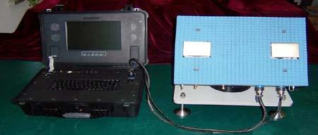
5 2. System Overview Two UAV Platforms Optical and SAR RS sensors System Components Comprehensive Cal&Val sites Data processing/analyzing systems Auxiliary support systems 5


6 2. System Overview - The Comprehensive C&V Site Two comprehensive Cal&Val test sites were preliminarily established, which have different climate characteristics, various land cover types and topographic features. Now they are being further developed so as to support multi-grade validation of airborne and spaceborne sensors for stable and long-term operation. North China site South China site 6


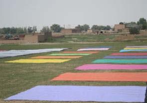


7 2. System Overview - The Comprehensive C&V Site Standard artificial and natural targets Knife-edge target Fan-shaped target Trihedral Corner Reflector Dihedral Corner Reflectors Rice Maize Gray-scale target Colored target Ku-band Active Transponder Potato Sunflower Three-bar target Layout of targets Surface parameters measurement Spectral curves Optical targets SAR targets Natural ground targets 7


8 2. System Overview - Data processing/analyzing system Data processing/analyzing system Data processing Radiometric performance assessment Geometric Performance Assessment Spectral Performance Assessment Radiometric correction Geometric correction Spectral correction Reflectance retrieval Vegetation index retrieval SAR data processing Absolute radiometric calibration Signal to Noise Ratio, SNR Dynamic range Response linear degree Radiometric resolution, NE ρ Ground resolution MTF Band registration precision Hyperspectral camera: central bandwidth; FWHM Multispectral camera: spectral response function 8

9 3. Inflight Calibration & Performance Assessment Flight campaigns Nov 2010 Campaign Airborne optical sensors in North China test site Jul 2011 Campaign Airborne optical and SAR sensors in South China test site Sep 2011 Campaign Airborne optical and SAR sensors in North China test site 9


 MFT-60 450nm MFT-60 650nm MFT-60 900nm MFT-30 450nm MFT-30")

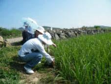
10 Inflight Calibration & Performance Assessment Atmospheric and field measurements Spectral reflectance of targets were measured. The aerosol optical thickness data and meteorological profile above the test site were synchronously collected :11:10 11:11:06 13:11:04 15:11:06 550nm aerosol optical thickness BRF 角度 ( ) MFT nm MFT nm MFT nm MFT nm MFT nm MFT nm MFT nm MFT nm MFT nm BRF properties of targets Spectral Target reflectance reflectance 实测靶标光谱反射率 by of filed gray-scale measurement targets Surface reflectance 60% 50% 40% 30% 20% 10% 0% Wave length(um) 50% 40% 30% 20% Radiosounding balloon :11:10 11:11:06 13:11:04 15:11:06 Moisture content Automatic sun tracking photometer, CE318 Automatic weather station 10
11 3. Inflight Calibration & Performance Assessment Cal&Val of Optical sensors Absolute radiometric calibration Gain Hyperspectral The inflight calibration coefficient The calibration coefficient at laboratory Channel Multispectral Flow chart of optical sensor radiometric calibration Radiometric calibration coefficients have very good linearity and the correlation coefficient reaches above 99%. 11


12 3. Inflight Calibration & Performance Assessment Cal&Val of Optical sensors Relative radiometric calibration Because of the variation in velocity height ratio, the images of hyperspectral imager between adjacent flight strips lack of comparability for different surfaces. A relative radiometric calibration method based on line frequency difference is proposed to solve this problem. 12
13 Real central wavelength Central wavelength 3. Inflight Calibration & Performance Assessment Cal&Val of Optical sensors Spectral calibration 中心波长 Spectral calibration for hyperspectral sensor 280~315 line Pixel line Pixel line Retrieval central wavelength based on flight data in Band 75 is O 2 absorption band. (laboratory measurement of Band 75 in Sep. 2010) (2) Shift of central wavelength in The shift of central wavelength is approximately 4~6nm compared to laboratory measurement. z 13

 Response rate Response rate wavelength")
14 3. Inflight Calibration & Performance Assessment Cal&Val of Optical sensors Spectral calibration Spectral calibration for multispectral sensor Difficulty: Solving of spectral response function faces ill-condition matrix Solutions: The spectral reflectance of 15 multispectral targets were measured to add the number of equations; Piecewise fitting SRF according to laboratory measurements Laboratory Retrieval Response rate Response rate wavelength (nm) Response rate Response rate wavelength (nm) wavelength (nm) 14


15 3. Inflight Calibration & Performance Assessment Cal&Val of Optical sensors True-color calibration A general true color calibration model is proposed based on the physical mechanism of color generation, which can fully employed all spectral information in VNIR reflection zones of hyperspectral images. In-situ measured spectral reflectance of the targets 1 At-sensor ideal true color of the targets M RGB > R' G ' B' = MODTRAN 2 True color correction coefficient matrix 4 Human visual color matching function Reconstructed true color of the targets & Images before true color correction 4 At-sensor radiance HSI image True color correction The corrected true-colored image

 (m) GSD(m) Panchromatic 0.7941 0.8153 0.35 B1 0.8889 0.8178 0.")
16 3. Inflight Calibration & Performance Assessment Cal&Val of Optical sensors Geometric performance Ground resolution Defined as the least ground distance or the least size of object that can be distinguished. Image of radiometric target Extracte the grey value from the circumference of radius equal to r Calculate the contrast of this radius Distinguish? No r = r+1 Yes Sensor GSD Panchromatic image in 2011 Hyperspectral image in 2011 Red line denotes the location of ground resolution estimated by our method. Blue line denotes the location of GSD. Green line denotes the location of ground resolution estimated by visual method. Camera Calculated Visual resolution Resolution(m) (m) GSD(m) Panchromatic B Multispectral B B B

17 3. Inflight Calibration & Performance Assessment Cal&Val of Optical sensors Geometric performance Geometric distortion Geometric distortion evaluation result of panchromatic image in Sep in Baotou city, China. Geometric distortion evaluation module External distortion Positioning error Internal distortion Data Type X-direction (m) Y-direction (m) Distance distortion (m) Angle distortion ( ) Geometric coarse correction Geometric precision correction After geometric precision correction, the positioning accuracy can reach a meter-scale and the image distortion has also been corrected well. 17


18 3. Inflight Calibration & Performance Assessment Cal&Val of SAR sensors SAR data processing system Raw Data Motion Compensation High resolution imaging processing Radiometric and geometric processing Interferometric Processing and DEM generation Polarimetric SAR data Processing and correction 18


19 3. Inflight Calibration & Performance Assessment Cal&Val of SAR sensors Relative radiometric calibration Before relative radiometric calibration After relative radiometric calibration 19
 ISLR(Integrated Side Lobe Ratio) Dynamic range. N o. Az. Res. (m) Rg.")


20 3. Inflight Calibration & Performance Assessment Cal&Val of SAR sensors data analyzing system Point target analysis DEM analysis Resolution PSLR(Peak Side Lobe Ratio) ISLR(Integrated Side Lobe Ratio) Dynamic range. N o. Az. Res. (m) Rg. Res. (m) Az. PSLR (db) Rg. PSLR (db) Az. ISLR (db) Rg. ISLR (db) Dy. Range (db) DEM accuracy ENL Radiometric resolution Distributed target analysis 20
21 3. Inflight Calibration & Performance Assessment Application performance reflectance retrieval and validation A Look Up Table (LUT) atmospheric correction model with adjacency effect correction was proposed to retrieve land surface reflectance. Target 1 Target 2 Target 3 Target 4 Colored targets in red frame ref1: at-sensor reflectance without atmospheric correction ref2: surface reflectance after atmospheric correction ref3: field measured reflectance It can be seen that the proposed method can eliminate the atmospheric effect well. 21
 was retrieved from hyperspectral data according")
 Accuracy of LAI retrieval model is less than 7%.")
 Validation results show that the retrieval error of LAI is approximately 21.")


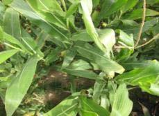
22 3. Inflight Calibration & Performance Assessment Application performance LAI retrieval and validation Leaf Area Index (LAI) was retrieved from hyperspectral data according to the image classification. Retrieve (1) Accuracy of LAI retrieval model is less than 7%. Airborne hyperspectral reflectance three-dimensional cube 5 Result of LAI retrieved (2) Validation results show that the retrieval error of LAI is approximately 21.7% with field measurement data. Accuracy of LAI retrieval model Six vegetation types Accuracy of LAI retrieval model for six vegetation types LAI Measured LAI Retrieved from Reflectance Measured Accuracy assessment using field measurements on Sep 3, (3) It might due to the retrieval error of reflectance, the saturation of NIR band with the increasing of LAI, the error of instruments. 22


23 4. Future Plan satellite Dome C Data process vehicle Command vehicle Airborne platform Baotou Comprehensive Cal&Val Site Aircraft Hangar Equipment store house Tower T&C vehicle Real-time monitoring of flight status Artificial target Natural scene Inflight and preflight geometric calibration 23


24
Study on LAI Sampling Strategy and Product Validation over Non-uniform Surface. Lingling Ma, Xiaohua Zhu, Yongguang Zhao
 of Opto Electronics Chinese of Sciences Study on LAI Sampling Strategy and Product Validation over Non-uniform Surface Lingling Ma, Xiaohua Zhu, Yongguang Zhao of (AOE) Chinese of Sciences (CAS) 2014-1-28
Quality assessment of RS data. Remote Sensing (GRS-20306)
") Quality assessment of RS data Remote Sensing (GRS-20306) Quality assessment General definition for quality assessment (Wikipedia) includes evaluation, grading and measurement process to assess design,
Quality assessment of RS data Remote Sensing (GRS-20306) Quality assessment General definition for quality assessment (Wikipedia) includes evaluation, grading and measurement process to assess design,
TOA RADIANCE SIMULATOR FOR THE NEW HYPERSPECTRAL MISSIONS: STORE (SIMULATOR OF TOA RADIANCE)
") TOA RADIANCE SIMULATOR FOR THE NEW HYPERSPECTRAL MISSIONS: STORE (SIMULATOR OF TOA RADIANCE) Malvina Silvestri Istituto Nazionale di Geofisica e Vulcanologia In the frame of the Italian Space Agency (ASI)
TOA RADIANCE SIMULATOR FOR THE NEW HYPERSPECTRAL MISSIONS: STORE (SIMULATOR OF TOA RADIANCE) Malvina Silvestri Istituto Nazionale di Geofisica e Vulcanologia In the frame of the Italian Space Agency (ASI)
Recent Progress of BaoTou Comprehensive Cal&Val Site. Prof. Chuan-rong Li. Academy of Opto-Electronics(AOE), Chinese Academy of Sciences
, Chinese Academy of Sciences") LANDNET WG meeting #4 CEOS/WGCV-41 Plenary Recent Progress of BaoTou Comprehensive Cal&Val Site Prof. Chuan-rong Li Academy of Opto-Electronics(AOE), Chinese Academy of Sciences National Remote Sensing
LANDNET WG meeting #4 CEOS/WGCV-41 Plenary Recent Progress of BaoTou Comprehensive Cal&Val Site Prof. Chuan-rong Li Academy of Opto-Electronics(AOE), Chinese Academy of Sciences National Remote Sensing
Hyperspectral Remote Sensing
 Hyperspectral Remote Sensing Multi-spectral: Several comparatively wide spectral bands Hyperspectral: Many (could be hundreds) very narrow spectral bands GEOG 4110/5100 30 AVIRIS: Airborne Visible/Infrared
THE EFFECT OF TOPOGRAPHIC FACTOR IN ATMOSPHERIC CORRECTION FOR HYPERSPECTRAL DATA
 THE EFFECT OF TOPOGRAPHIC FACTOR IN ATMOSPHERIC CORRECTION FOR HYPERSPECTRAL DATA Tzu-Min Hong 1, Kun-Jen Wu 2, Chi-Kuei Wang 3* 1 Graduate student, Department of Geomatics, National Cheng-Kung University
ALOS-2/PALSAR-2 Calibration and Validation Results
 ALOS-2/PALSAR-2 Calibration and Validation Results Ver. 2018.08.07 JAXA EORC & ALOS-2 Project Team 1 Content 1. Update of the calibration factor (CF) 2. Evaluation results for PALSAR-2 standard products
End-to-End Simulation of Sentinel-2 Data with Emphasis on Atmospheric Correction Methods
 End-to-End Simulation of Sentinel-2 Data with Emphasis on Atmospheric Correction Methods Luis Guanter 1, Karl Segl 2, Hermann Kaufmann 2 (1) Institute for Space Sciences, Freie Universität Berlin, Germany
A Method Suitable for Vicarious Calibration of a UAV Hyperspectral Remote Sensor
 A Method Suitable for Vicarious Calibration of a UAV Hyperspectral Remote Sensor Hao Zhang 1, Haiwei Li 1, Benyong Yang 2, Zhengchao Chen 1 1. Institute of Remote Sensing and Digital Earth (RADI), Chinese
Correction and Calibration 2. Preprocessing
 Correction and Calibration Reading: Chapter 7, 8. 8.3 ECE/OPTI 53 Image Processing Lab for Remote Sensing Preprocessing Required for certain sensor characteristics and systematic defects Includes: noise
ENMAP RADIOMETRIC INFLIGHT CALIBRATION
 ENMAP RADIOMETRIC INFLIGHT CALIBRATION Harald Krawczyk 1, Birgit Gerasch 1, Thomas Walzel 1, Tobias Storch 1, Rupert Müller 1, Bernhard Sang 2, Christian Chlebek 3 1 Earth Observation Center (EOC), German
INTEGRATION OF TREE DATABASE DERIVED FROM SATELLITE IMAGERY AND LIDAR POINT CLOUD DATA
 INTEGRATION OF TREE DATABASE DERIVED FROM SATELLITE IMAGERY AND LIDAR POINT CLOUD DATA S. C. Liew 1, X. Huang 1, E. S. Lin 2, C. Shi 1, A. T. K. Yee 2, A. Tandon 2 1 Centre for Remote Imaging, Sensing
GEOMETRY AND RADIATION QUALITY EVALUATION OF GF-1 AND GF-2 SATELLITE IMAGERY. Yong Xie
 Prepared by CNSA Agenda Item: WG.3 GEOMETRY AND RADIATION QUALITY EVALUATION OF GF-1 AND GF-2 SATELLITE IMAGERY Yong Xie Institute of Remote Sensing and Digital Earth, Chinese Academy of Science GF-1 and
GENESIS Generator of Spectral Image Simulations
 MBT Space Division - GENESIS Generator of Spectral Image Simulations Dr. Yael Efraim, Dr. N. Cohen, Dr. G. Tidhar, Dr. T. Feingersh Dec 2017 1 Scope GENESIS: End-to-end simulation of hyper-spectral (HS)
IASI spectral calibration monitoring on MetOp-A and MetOp-B
 IASI spectral calibration monitoring on MetOp-A and MetOp-B E. Jacquette (1), B. Tournier (2), E. Péquignot (1), J. Donnadille (2), D. Jouglet (1), V. Lonjou (1), J. Chinaud (1), C. Baque (3), L. Buffet
Airborne Hyperspectral Imaging Using the CASI1500
 Airborne Hyperspectral Imaging Using the CASI1500 AGRISAR/EAGLE 2006, ITRES Research CASI 1500 overview A class leading VNIR sensor with extremely sharp optics. 380 to 1050nm range 288 spectral bands ~1500
Missile Simulation in Support of Research, Development, Test Evaluation and Acquisition
 NDIA 2012 Missile Simulation in Support of Research, Development, Test Evaluation and Acquisition 15 May 2012 Briefed by: Stephanie Brown Reitmeier United States Army Aviation and Missile Research, Development,
ISPRS Hannover Workshop 2013, May 2013, Hannover, Germany
 New light-weight stereosopic spectrometric airborne imaging technology for highresolution environmental remote sensing Case studies in water quality mapping E. Honkavaara, T. Hakala, K. Nurminen, L. Markelin,
Optical Theory Basics - 2 Atmospheric corrections and parameter retrieval
 Optical Theory Basics - 2 Atmospheric corrections and parameter retrieval Jose Moreno 3 September 2007, Lecture D1Lb2 OPTICAL THEORY-FUNDAMENTALS (2) Radiation laws: definitions and nomenclature Sources
LAB EXERCISE NO. 02 DUE DATE: 9/22/2015 Total Points: 4 TOPIC: TOA REFLECTANCE COMPUTATION FROM LANDSAT IMAGES
 LAB EXERCISE NO. 02 DUE DATE: 9/22/2015 Total Points: 4 TOPIC: TOA REFLECTANCE COMPUTATION FROM LANDSAT IMAGES You are asked to perform a radiometric conversion from raw digital numbers to reflectance
CHRIS Proba Workshop 2005 II
 CHRIS Proba Workshop 25 Analyses of hyperspectral and directional data for agricultural monitoring using the canopy reflectance model SLC Progress in the Upper Rhine Valley and Baasdorf test-sites Dr.
In addition, the image registration and geocoding functionality is also available as a separate GEO package.
 GAMMA Software information: GAMMA Software supports the entire processing from SAR raw data to products such as digital elevation models, displacement maps and landuse maps. The software is grouped into
Potential of Sentinel-2 for retrieval of biophysical and biochemical vegetation parameters
 Insert the title of your slide Potential of Sentinel-2 for retrieval of biophysical and biochemical vegetation parameters D. Scheffler, T. Kuester, K. Segl, D. Spengler and H. Kaufmann Motivation Insert
Update on S3 SYN-VGT algorithm status PROBA-V QWG 4 24/11/2016
 ACRI-ST S3MPC 2014-2016 Update on S3 SYN-VGT algorithm status PROBA-V QWG 4 24/11/2016 Agenda Continuity with PROBA-V data - Evolution of S3 SYN / Creation of an alternative Proba-V like processing chain
GEOG 4110/5100 Advanced Remote Sensing Lecture 2
 GEOG 4110/5100 Advanced Remote Sensing Lecture 2 Data Quality Radiometric Distortion Radiometric Error Correction Relevant reading: Richards, sections 2.1 2.8; 2.10.1 2.10.3 Data Quality/Resolution Spatial
Remote Sensing Introduction to the course
 Remote Sensing Introduction to the course Remote Sensing (Prof. L. Biagi) Exploitation of remotely assessed data for information retrieval Data: Digital images of the Earth, obtained by sensors recording
9/14/2011. Contents. Lecture 3: Spatial Data Acquisition in GIS. Dr. Bo Wu Learning Outcomes. Data Input Stream in GIS
 Contents Lecture 3: Spatial Data Acquisition in GIS Dr. Bo Wu lsbowu@polyu.edu.hk 1. Learning outcomes. Data acquisition: Manual digitization 3. Data acquisition: Field survey 4. Data acquisition: Remote
Multi-sensors vicarious calibration activities at CNES
 Multi-sensors vicarious calibration activities at CNES Patrice Henry, Bertrand Fougnie June 11, 2013 CNES background in image quality monitoring of operational Earth observation systems Since the launch
Attività cal/val missione FLEX e possibili sinergie con PRISMA
 Attività cal/val missione FLEX e possibili sinergie con PRISMA Colombo R. 1, Miglietta F. 2, Cogliati S. 1 1 Department of Earth and Environmental Sciences, University Milano-Bicocca, Milano, Italy 2 CNR-IBIMET,
Adaptive Doppler centroid estimation algorithm of airborne SAR
 Adaptive Doppler centroid estimation algorithm of airborne SAR Jian Yang 1,2a), Chang Liu 1, and Yanfei Wang 1 1 Institute of Electronics, Chinese Academy of Sciences 19 North Sihuan Road, Haidian, Beijing
ENY-C2005 Geoinformation in Environmental Modeling Lecture 4b: Laser scanning
 1 ENY-C2005 Geoinformation in Environmental Modeling Lecture 4b: Laser scanning Petri Rönnholm Aalto University 2 Learning objectives To recognize applications of laser scanning To understand principles
2010 LiDAR Project. GIS User Group Meeting June 30, 2010
 2010 LiDAR Project GIS User Group Meeting June 30, 2010 LiDAR = Light Detection and Ranging Technology that utilizes lasers to determine the distance to an object or surface Measures the time delay between
OCEANSAT-2 OCEAN COLOUR MONITOR (OCM-2)
") OCEANSAT-2 OCEAN COLOUR MONITOR (OCM-2) Update of post launch vicarious, lunar calibrations & current status Presented by Prakash Chauhan Space Applications Centre Indian Space Research Organistaion Ahmedabad-
OCEANSAT-2 OCEAN COLOUR MONITOR (OCM-2) Update of post launch vicarious, lunar calibrations & current status Presented by Prakash Chauhan Space Applications Centre Indian Space Research Organistaion Ahmedabad-
Retrieval of crop characteristics from high resolution airborne scanner data
 Retrieval of crop characteristics from high resolution airborne scanner data K. Richter 1, F. Vuolo 2, G. D Urso 1, G. Fernandez 3 1 DIIAT, Facoltà di Agraria, Università degli studi di Napoli Federico
Locating the Shadow Regions in LiDAR Data: Results on the SHARE 2012 Dataset
 Locating the Shadow Regions in LiDAR Data: Results on the SHARE 22 Dataset Mustafa BOYACI, Seniha Esen YUKSEL* Hacettepe University, Department of Electrical and Electronics Engineering Beytepe, Ankara,
Estimating forest parameters from top-of-atmosphere radiance data
 Estimating forest parameters from top-of-atmosphere radiance data V. Laurent*, W. Verhoef, J. Clevers, M. Schaepman *Contact: valerie.laurent@wur.nl Guest lecture, RS course, 8 th Decembre, 2010 Contents
RADIOMETRIC CROSS-CALIBRATION OF GAOFEN-1 WFV CAMERAS WITH LANDSAT-8 OLI AND MODIS SENSORS BASED ON RADIATION AND GEOMETRY MATCHING
 RADIOMETRIC CROSS-CALIBRATION OF GAOFEN-1 WFV CAMERAS WITH LANDSAT-8 OLI AND MODIS SENSORS BASED ON RADIATION AND GEOMETRY MATCHING Li Junping 1, Wu Zhaocong 2, Wei xin 1, Zhang Yi 2, Feng Fajie 1, Guo
Sensors and applications for drone based remote sensing
 Sensors and applications for drone based remote sensing Dr. Ilkka Pölönen Dr. Eija Honkavaara, NLS Dr. Heikki Saari, VTT Dr. Sakari Tuominen, Mr. Jere Kaivosoja, Luke Laboratory Joint research with Finnish
IMPROVED TARGET DETECTION IN URBAN AREA USING COMBINED LIDAR AND APEX DATA
 IMPROVED TARGET DETECTION IN URBAN AREA USING COMBINED LIDAR AND APEX DATA Michal Shimoni 1 and Koen Meuleman 2 1 Signal and Image Centre, Dept. of Electrical Engineering (SIC-RMA), Belgium; 2 Flemish
Automated Hyperspectral Target Detection and Change Detection from an Airborne Platform: Progress and Challenges
 Automated Hyperspectral Target Detection and Change Detection from an Airborne Platform: Progress and Challenges July 2010 Michael Eismann, AFRL Joseph Meola, AFRL Alan Stocker, SCC Presentation Outline
Update on Pre-Cursor Calibration Analysis of Sentinel 2. Dennis Helder Nischal Mishra Larry Leigh Dave Aaron
 Update on Pre-Cursor Calibration Analysis of Sentinel 2 Dennis Helder Nischal Mishra Larry Leigh Dave Aaron Background The value of Sentinel-2 data, to the Landsat world, will be entirely dependent on
Analysis Ready Data For Land (CARD4L-ST)
") Analysis Ready Data For Land Product Family Specification Surface Temperature (CARD4L-ST) Document status For Adoption as: Product Family Specification, Surface Temperature This Specification should next
Analysis Ready Data For Land Product Family Specification Surface Temperature (CARD4L-ST) Document status For Adoption as: Product Family Specification, Surface Temperature This Specification should next
Geometric Rectification of Remote Sensing Images
 Geometric Rectification of Remote Sensing Images Airborne TerrestriaL Applications Sensor (ATLAS) Nine flight paths were recorded over the city of Providence. 1 True color ATLAS image (bands 4, 2, 1 in
THE USE OF AIRBORNE HYPERSPECTRAL REFLECTANCE DATA TO CHARACTERIZE FOREST SPECIES DISTRIBUTION PATTERNS
 THE USE OF AIRBORNE HYPERSPECTRAL REFLECTANCE DATA TO CHARACTERIZE FOREST SPECIES DISTRIBUTION PATTERNS Weihs, P., Huber K. Institute of Meteorology, Department of Water, Atmosphere and Environment, BOKU
Video Georegistration: Key Challenges. Steve Blask Harris Corporation GCSD Melbourne, FL 32934
 Video Georegistration: Key Challenges Steve Blask sblask@harris.com Harris Corporation GCSD Melbourne, FL 32934 Definitions Registration: image to image alignment Find pixel-to-pixel correspondences between
Course Outline (1) #6 Data Acquisition for Built Environment. Fumio YAMAZAKI
 #6 Data Acquisition for Built Environment. Fumio YAMAZAKI") AT09.98 Applied GIS and Remote Sensing for Disaster Mitigation #6 Data Acquisition for Built Environment 9 October, 2002 Fumio YAMAZAKI yamazaki@ait.ac.th http://www.star.ait.ac.th/~yamazaki/ Course Outline
AT09.98 Applied GIS and Remote Sensing for Disaster Mitigation #6 Data Acquisition for Built Environment 9 October, 2002 Fumio YAMAZAKI yamazaki@ait.ac.th http://www.star.ait.ac.th/~yamazaki/ Course Outline
Three-dimensional digital elevation model of Mt. Vesuvius from NASA/JPL TOPSAR
 Cover Three-dimensional digital elevation model of Mt. Vesuvius from NASA/JPL TOPSAR G.ALBERTI, S. ESPOSITO CO.RI.S.T.A., Piazzale V. Tecchio, 80, I-80125 Napoli, Italy and S. PONTE Department of Aerospace
The Gain setting for Landsat 7 (High or Low Gain) depends on: Sensor Calibration - Application. the surface cover types of the earth and the sun angle
 depends on: Sensor Calibration - Application. the surface cover types of the earth and the sun angle") Sensor Calibration - Application Station Identifier ASN Scene Center atitude 34.840 (34 3'0.64"N) Day Night DAY Scene Center ongitude 33.03270 (33 0'7.72"E) WRS Path WRS Row 76 036 Corner Upper eft atitude
Sensor Calibration - Application Station Identifier ASN Scene Center atitude 34.840 (34 3'0.64"N) Day Night DAY Scene Center ongitude 33.03270 (33 0'7.72"E) WRS Path WRS Row 76 036 Corner Upper eft atitude
Measuring Ground Deformation using Optical Imagery
 Measuring Ground Deformation using Optical Imagery Sébastien Leprince California Institute of Technology, USA October 29, 2009 Keck Institute for Space Studies Workshop Measuring Horizontal Ground Displacement,
A MAXIMUM NOISE FRACTION TRANSFORM BASED ON A SENSOR NOISE MODEL FOR HYPERSPECTRAL DATA. Naoto Yokoya 1 and Akira Iwasaki 2
 A MAXIMUM NOISE FRACTION TRANSFORM BASED ON A SENSOR NOISE MODEL FOR HYPERSPECTRAL DATA Naoto Yokoya 1 and Akira Iwasaki 1 Graduate Student, Department of Aeronautics and Astronautics, The University of
Sentinel-2 Calibration and Validation : from the Instrument to Level 2 Products
 Sentinel-2 Calibration and Validation : from the Instrument to Level 2 Products Vincent Lonjou a, Thierry Tremas a, Sophie Lachérade a, Cécile Dechoz a, Florie Languille a, Aimé Meygret a, Olivier Hagolle
Coherence Based Polarimetric SAR Tomography
 I J C T A, 9(3), 2016, pp. 133-141 International Science Press Coherence Based Polarimetric SAR Tomography P. Saranya*, and K. Vani** Abstract: Synthetic Aperture Radar (SAR) three dimensional image provides
Reprocessing of Suomi NPP CrIS SDR and Impacts on Radiometric and Spectral Long-term Accuracy and Stability
 Reprocessing of Suomi NPP CrIS SDR and Impacts on Radiometric and Spectral Long-term Accuracy and Stability Yong Chen *1, Likun Wang 1, Denis Tremblay 2, and Changyong Cao 3 1.* University of Maryland,
Supplementary materials of Multispectral imaging using a single bucket detector
 Supplementary materials of Multispectral imaging using a single bucket detector Liheng Bian 1, Jinli Suo 1,, Guohai Situ 2, Ziwei Li 1, Jingtao Fan 1, Feng Chen 1 and Qionghai Dai 1 1 Department of Automation,
DEVELOPMENT OF ORIENTATION AND DEM/ORTHOIMAGE GENERATION PROGRAM FOR ALOS PRISM
 DEVELOPMENT OF ORIENTATION AND DEM/ORTHOIMAGE GENERATION PROGRAM FOR ALOS PRISM Izumi KAMIYA Geographical Survey Institute 1, Kitasato, Tsukuba 305-0811 Japan Tel: (81)-29-864-5944 Fax: (81)-29-864-2655
University of Technology Building & Construction Department / Remote Sensing & GIS lecture
 5. Corrections 5.1 Introduction 5.2 Radiometric Correction 5.3 Geometric corrections 5.3.1 Systematic distortions 5.3.2 Nonsystematic distortions 5.4 Image Rectification 5.5 Ground Control Points (GCPs)
TOPOGRAPHIC NORMALIZATION INTRODUCTION
 TOPOGRAPHIC NORMALIZATION INTRODUCTION Use of remotely sensed data from mountainous regions generally requires additional preprocessing, including corrections for relief displacement and solar illumination
Prototyping GOES-R Albedo Algorithm Based on MODIS Data Tao He a, Shunlin Liang a, Dongdong Wang a
 Prototyping GOES-R Albedo Algorithm Based on MODIS Data Tao He a, Shunlin Liang a, Dongdong Wang a a. Department of Geography, University of Maryland, College Park, USA Hongyi Wu b b. University of Electronic
Optimizing LUT-based RTM inversion for retrieval of biophysical parameters
 Optimizing LUT-based RTM inversion for retrieval of biophysical parameters Jochem Verrelst 1, Juan Pablo Rivera 1, Anna Leoneko 2, Luis Alonso 1, Jose Moreno 1 1 : University of Valencia, Spain 2 : Swansea
DEVELOPMENT OF CAMERA MODEL AND GEOMETRIC CALIBRATION/VALIDATION OF XSAT IRIS IMAGERY
 DEVELOPMENT OF CAMERA MODEL AND GEOMETRIC CALIBRATION/VALIDATION OF XSAT IRIS IMAGERY Leong Keong Kwoh, Xiaojing Huang, Wee Juan Tan Centre for Remote, Imaging Sensing and Processing (CRISP), National
Prof. Vidya Manian Dept. of Electrical l and Comptuer Engineering. INEL6007(Spring 2010) ECE, UPRM
 ECE, UPRM") Inel 6007 Introduction to Remote Sensing Chapter 5 Spectral Transforms Prof. Vidya Manian Dept. of Electrical l and Comptuer Engineering Chapter 5-1 MSI Representation Image Space: Spatial information
Inel 6007 Introduction to Remote Sensing Chapter 5 Spectral Transforms Prof. Vidya Manian Dept. of Electrical l and Comptuer Engineering Chapter 5-1 MSI Representation Image Space: Spatial information
Payloads. Which one(s) are right for your organization?
 are right for your organization?") Payloads Which one(s) are right for your organization? What is a payload anyway? Not as simple as it may sound and critically important. Integrated and fixed? Interchangeable? Field changeable? Impact
Payloads Which one(s) are right for your organization? What is a payload anyway? Not as simple as it may sound and critically important. Integrated and fixed? Interchangeable? Field changeable? Impact
Repeat-pass SAR Interferometry Experiments with Gaofen-3: A Case Study of Ningbo Area
 Repeat-pass SAR Interferometry Experiments with Gaofen-3: A Case Study of Ningbo Area Tao Zhang, Xiaolei Lv, Bing Han, Bin Lei and Jun Hong Key Laboratory of Technology in Geo-spatial Information Processing
Aardobservatie en Data-analyse Image processing
 Aardobservatie en Data-analyse Image processing 1 Image processing: Processing of digital images aiming at: - image correction (geometry, dropped lines, etc) - image calibration: DN into radiance or into
10/2/2012 Corporate Headquarters 9390 Gateway Dr, Ste 100 Reno, NV p: f:
 SRS Project Report 1538 R.I.T. 10/2/2012 Corporate Headquarters 9390 Gateway Dr, Ste 100 Reno, NV 89521 p: 775.329.6660 f: 775.329.6668 Table of Contents 1 Overview 2 Acquisition Summary 3 4 2.1 Collection
Interactive comment on Quantification and mitigation of the impact of scene inhomogeneity on Sentinel-4 UVN UV-VIS retrievals by S. Noël et al.
 Atmos. Meas. Tech. Discuss., www.atmos-meas-tech-discuss.net/5/c741/2012/ Author(s) 2012. This work is distributed under the Creative Commons Attribute 3.0 License. Atmospheric Measurement Techniques Discussions
Interactive comment on Quantification and mitigation of the impact of scene inhomogeneity on Sentinel-4 UVN UV-VIS retrievals by S. Noël et al.
 Atmos. Meas. Tech. Discuss., 5, C741 C750, 2012 www.atmos-meas-tech-discuss.net/5/c741/2012/ Author(s) 2012. This work is distributed under the Creative Commons Attribute 3.0 License. Atmospheric Measurement
Developing Conception of China National China Earth Observation. High Resolution Earth Observation Data Grid for Public Service
 Developing Conception of China National China Earth Observation High Resolution Earth Observation Data Grid for Public Service The Earth Observation System and Data Center, CNSA April 18, 2012 Outlines
Geometric Accuracy Evaluation, DEM Generation and Validation for SPOT-5 Level 1B Stereo Scene
 Geometric Accuracy Evaluation, DEM Generation and Validation for SPOT-5 Level 1B Stereo Scene Buyuksalih, G.*, Oruc, M.*, Topan, H.*,.*, Jacobsen, K.** * Karaelmas University Zonguldak, Turkey **University
Memorandum. Clint Slatton Prof. Brian Evans Term project idea for Multidimensional Signal Processing (EE381k)
") Memorandum From: To: Subject: Date : Clint Slatton Prof. Brian Evans Term project idea for Multidimensional Signal Processing (EE381k) 16-Sep-98 Project title: Minimizing segmentation discontinuities in
Memorandum From: To: Subject: Date : Clint Slatton Prof. Brian Evans Term project idea for Multidimensional Signal Processing (EE381k) 16-Sep-98 Project title: Minimizing segmentation discontinuities in
CHRIS PROBA instrument
 CHRIS PROBA instrument Wout Verhoef ITC, The Netherlands verhoef @itc.nl 29 June 2009, D1L5 Contents Satellite and instrument Images Multi-angular analysis Toolbox CHRIS-PROBA PROBA-CHRIS Project for On-Board
Analysis Ready Data For Land
 Analysis Ready Data For Land Product Family Specification Optical Surface Reflectance (CARD4L-OSR) Document status For Adoption as: Product Family Specification, Surface Reflectance, Working Draft (2017)
Overview of the EnMAP Imaging Spectroscopy Mission
 Overview of the EnMAP Imaging Spectroscopy Mission L. Guanter, H. Kaufmann, K. Segl, S. Foerster, T. Storch, A. Mueller, U. Heiden, M. Bachmann, G. Rossner, C. Chlebek, S. Fischer, B. Sang, the EnMAP Science
Vicarious Radiometric Calibration of MOMS at La Crau Test Site and Intercalibration with SPOT
 Vicarious Radiometric Calibration of MOMS at La Crau Test Site and Intercalibration with SPOT M. Schroeder, R. Müller, P. Reinartz German Aerospace Center, DLR Institute of Optoelectronics, Optical Remote
IMAGING AND FIELD SPECTROMETER DATA S ROLE IN CALIBRATING CLIMATE-QUALITE SENSORS Kurtis, J. Thome NASA/GSFC Greenbelt, MD
 IMAGING AND FIELD SPECTROMETER DATA S ROLE IN CALIBRATING CLIMATE-QUALITE SENSORS Kurtis, J. Thome NASA/GSFC Greenbelt, MD Abstract The role of hyperspectral data and imaging spectrometry in the calibration
Do It Yourself 8. Polarization Coherence Tomography (P.C.T) Training Course
 Training Course") Do It Yourself 8 Polarization Coherence Tomography (P.C.T) Training Course 1 Objectives To provide a self taught introduction to Polarization Coherence Tomography (PCT) processing techniques to enable
Do It Yourself 8 Polarization Coherence Tomography (P.C.T) Training Course 1 Objectives To provide a self taught introduction to Polarization Coherence Tomography (PCT) processing techniques to enable
Hyperspectral and Multispectral Image Fusion Using Local Spatial-Spectral Dictionary Pair
 Hyperspectral and Multispectral Image Fusion Using Local Spatial-Spectral Dictionary Pair Yifan Zhang, Tuo Zhao, and Mingyi He School of Electronics and Information International Center for Information
Atmospheric correction of hyperspectral ocean color sensors: application to HICO
 Atmospheric correction of hyperspectral ocean color sensors: application to HICO Amir Ibrahim NASA GSFC / USRA Bryan Franz, Zia Ahmad, Kirk knobelspiesse (NASA GSFC), and Bo-Cai Gao (NRL) Remote sensing
2017 Summer Course on Optical Oceanography and Ocean Color Remote Sensing. Introduction to Remote Sensing
 2017 Summer Course on Optical Oceanography and Ocean Color Remote Sensing Introduction to Remote Sensing Curtis Mobley Delivered at the Darling Marine Center, University of Maine July 2017 Copyright 2017
SEA BOTTOM MAPPING FROM ALOS AVNIR-2 AND QUICKBIRD SATELLITE DATA
 SEA BOTTOM MAPPING FROM ALOS AVNIR-2 AND QUICKBIRD SATELLITE DATA Mohd Ibrahim Seeni Mohd, Nurul Nadiah Yahya, Samsudin Ahmad Faculty of Geoinformation and Real Estate, Universiti Teknologi Malaysia, 81310
PolSARpro v4.03 Forest Applications
 PolSARpro v4.03 Forest Applications Laurent Ferro-Famil Lecture on polarimetric SAR Theory and applications to agriculture & vegetation Thursday 19 April, morning Pol-InSAR Tutorial Forest Application
Shallow-water Remote Sensing: Lecture 1: Overview
 Shallow-water Remote Sensing: Lecture 1: Overview Curtis Mobley Vice President for Science and Senior Scientist Sequoia Scientific, Inc. Bellevue, WA 98005 curtis.mobley@sequoiasci.com IOCCG Course Villefranche-sur-Mer,
Infrared Scene Simulation for Chemical Standoff Detection System Evaluation
 Infrared Scene Simulation for Chemical Standoff Detection System Evaluation Peter Mantica, Chris Lietzke, Jer Zimmermann ITT Industries, Advanced Engineering and Sciences Division Fort Wayne, Indiana Fran
Geometric Correction
 CEE 6150: Digital Image Processing Geometric Correction 1 Sources of Distortion Sensor Characteristics optical distortion aspect ratio non-linear mirror velocity detector geometry & scanning sequence Viewing
Terrain categorization using LIDAR and multi-spectral data
 Terrain categorization using LIDAR and multi-spectral data Angela M. Puetz, R. C. Olsen, Michael A. Helt U.S. Naval Postgraduate School, 833 Dyer Road, Monterey, CA 93943 ampuetz@nps.edu, olsen@nps.edu
DIGITAL SURFACE MODELS OF CITY AREAS BY VERY HIGH RESOLUTION SPACE IMAGERY
 DIGITAL SURFACE MODELS OF CITY AREAS BY VERY HIGH RESOLUTION SPACE IMAGERY Jacobsen, K. University of Hannover, Institute of Photogrammetry and Geoinformation, Nienburger Str.1, D30167 Hannover phone +49
Application of Hyperspectral Remote Sensing for LAI Estimation in Precision Farming
 Preprint/Prétirage Application of Hyperspectral Remote Sensing for LAI Estimation in Precision Farming Anna Pacheco, Abdou Bannari Remote Sensing and Geomatics of Environment Laboratory Department of Geography,
RESOLUTION enhancement is achieved by combining two
 IEEE GEOSCIENCE AND REMOTE SENSING LETTERS, VOL. 3, NO. 1, JANUARY 2006 135 Range Resolution Improvement of Airborne SAR Images Stéphane Guillaso, Member, IEEE, Andreas Reigber, Member, IEEE, Laurent Ferro-Famil,
Interferometric processing. Rüdiger Gens
 Rüdiger Gens Why InSAR processing? extracting three-dimensional information out of a radar image pair covering the same area digital elevation model change detection 2 Processing chain 3 Processing chain
Radar Data Processing, Quality Analysis and Level-1b Product Generation for AGRISAR and EAGLE campaigns
 Radar Data Processing, Quality Analysis and Level-1b Product Generation for AGRISAR and EAGLE campaigns German Aerospace Center (DLR) R. Scheiber, M. Keller, J. Fischer, R. Horn, I. Hajnsek Outline E-SAR
Introduction to Remote Sensing Wednesday, September 27, 2017
 Lab 3 (200 points) Due October 11, 2017 Multispectral Analysis of MASTER HDF Data (ENVI Classic)* Classification Methods (ENVI Classic)* SAM and SID Classification (ENVI Classic) Decision Tree Classification
ALOS-2 PALSAR-2 support in GAMMA Software
 ALOS-2 PALSAR-2 support in GAMMA Software Urs Wegmüller, Charles Werner, Andreas Wiesmann, Gamma Remote Sensing AG CH-3073 Gümligen, http://www.gamma-rs.ch 11-Sep-2014 1. Introduction JAXA has made available
ENVI Automated Image Registration Solutions
 ENVI Automated Image Registration Solutions Xiaoying Jin Harris Corporation Table of Contents Introduction... 3 Overview... 4 Image Registration Engine... 6 Image Registration Workflow... 8 Technical Guide...
PSI Precision, accuracy and validation aspects
 PSI Precision, accuracy and validation aspects Urs Wegmüller Charles Werner Gamma Remote Sensing AG, Gümligen, Switzerland, wegmuller@gamma-rs.ch Contents Aim is to obtain a deeper understanding of what
SEVENTH FRAMEWORK PROGRAMME Capacities Specific Programme Research Infrastructures
 SEVENTH FRAMEWORK PROGRAMME Capacities Specific Programme Research Infrastructures Project acronym: EUFAR Project full title: European Facility for Airborne Research in Environmental and Geo-sciences Proposal
fraction of Nyquist
 differentiator 4 2.1.2.3.4.5.6.7.8.9 1 1 1/integrator 5.1.2.3.4.5.6.7.8.9 1 1 gain.5.1.2.3.4.5.6.7.8.9 1 fraction of Nyquist Figure 1. (top) Transfer functions of differential operators (dotted ideal derivative,
GEOG 4110/5100 Advanced Remote Sensing Lecture 4
 GEOG 4110/5100 Advanced Remote Sensing Lecture 4 Geometric Distortion Relevant Reading: Richards, Sections 2.11-2.17 Review What factors influence radiometric distortion? What is striping in an image?
STARTING WITH DRONES. Data Collection and Remote Sensing with UAVs, etc. Dr. Bill Hazelton LS
 STARTING WITH DRONES Data Collection and Remote Sensing with UAVs, etc. Dr. Bill Hazelton LS What this Talk is About UAV-based data acquisition: What you need to get involved Processes in getting spatial
Calibration Techniques for NASA s Remote Sensing Ocean Color Sensors
 Calibration Techniques for NASA s Remote Sensing Ocean Color Sensors Gerhard Meister, Gene Eplee, Bryan Franz, Sean Bailey, Chuck McClain NASA Code 614.2 Ocean Biology Processing Group October 21st, 2010
Application of the SCAPE-M atmospheric correction algorithm to the processing of MERIS data over continental water bodies
 Application of the SCAPE-M atmospheric correction algorithm to the processing of MERIS data over continental water bodies L. Guanter 1, J. A. Domínguez 2, L. Conde 2, A. Ruiz-Verdú 2, V. Estellés 3, R.