Leica Public Safety Solutions Versatile. Durable. Admissible
|
|
|
- Rachel Morrison
- 6 years ago
- Views:
Transcription


1 Leica Public Safety Solutions Versatile. Durable. Admissible


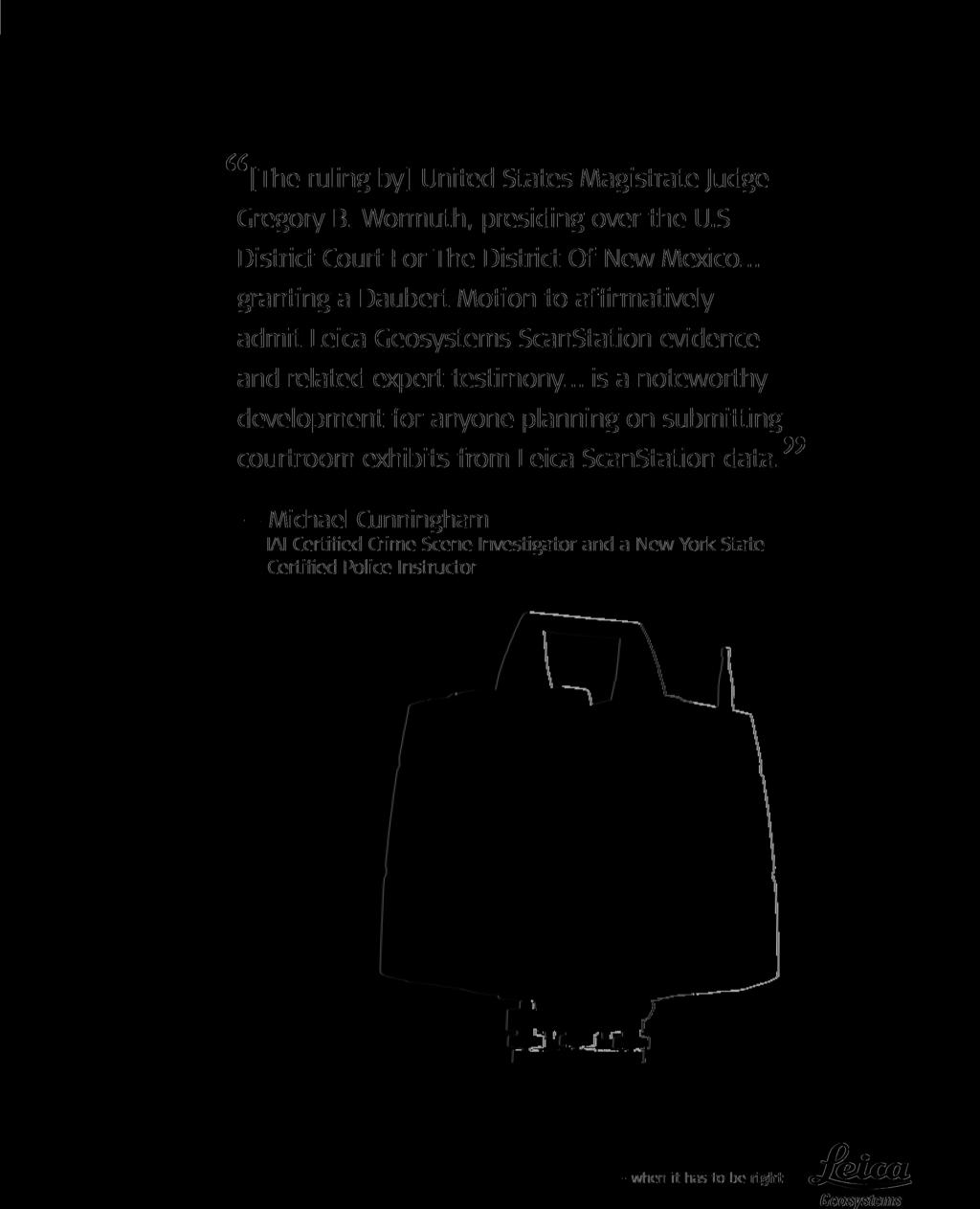
2 Public Safety Solutions 3D Laser Scanners Software Training and Consulting Services Leica ScanStation PS Series Professional Grade 3D Laser Scanning Solutions for Public Safety Applications Leica Geosystems now offers public safety professionals three different choices of ScanStations to enable our customers to choose the scanning solution which best meet both their mission requirements and budget. While price and performance vary depending upon model, all Leica ScanStations share the same professional-grade construction, durability and weather resistance, renowned reliability, easy of use and documented admissibility in U.S. courts of law. And all of this is backed by Leica s best-inclass public safety training and customer support. *Leica ScanStation PS20 shown L EI C A G E O S Y S T E M S L EI C A G E O S Y S T E M S L EI C A G E O S Y S T E M S Applications Crime Scene Investigations Post-Blast Investigations Bullet Path Reconstruction Security and Pre-Event Planning Medicolegal Death Investigation Disaster Recovery Weapons of Mass Destruction Incidents Critical Infrastructure Protection Crash Investigations Fire and Arson Investigations Leica ScanStation PS Series Fast. Durable. Versatile. Admissible. No need for Laser Safety Glasses Daubert Tested NIST Traceable Measurements A True Solution from The World Leader Professional Grade Products with Quality Manufacturer Training Provided by New York Police Department Detective First Grade (ret.) Mike Cunningham. NYPD Detective First Grade (ret.) Mike Cunningham has joined the Leica Public Safety Group as our Training and Service Operation Manager. After a 26 year career, Mike retired from the New York City Police Department in 2012 as the senior ranking Investigator in their Crime Scene Unit. In addition to his many years of CSI experience he was a forensics instructor for the NYPD and is a Certified Instructor for Department of Homeland Security. Mike served his country with distinction and professionalism for ten months at Ground Zero in the aftermath of 9/11. He is an IAI Certified Crime Scene Investigator and a New York State Certified Police Instructor. His experience will directly benefit our customers.
3 NEW! GET BRIEFED IN THE READY ROOM The Leica Geosystems Ready Room provides commentary, insights and news you need to successfully apply 3D laser scanning and other geospatial technologies on crime scene, crash and arson investigations. Visit for the latest on grant assistance, legislation, technology trends and more. Services Free Grant Assistance Don t let budget limitations slow you down. Leica Geosystems, together with PoliceGrantsHelp.com, can aid you in locating eligible forensic and homeland security grants and even assist with the grant applications. New Technology Deployment Consultation Led by experienced forensic investigators, this service is designed to help your agency incorporate new measurement technologies into existing operations. Training Services Take advantage of high-quality and comprehensive training specifically tailored to your agency s needs, covering hardware, software and the proven workflows you need to laser scan a scene and extract the exhibits needed to support the mission. Standard Operating Procedure Development This specialized program provides you with 40 hours of custom consultation to ensure that the work is properly carried out by trained technicians and that the digital evidence produced is in compliance with accepted standards such as ISO To get more details about any of these services, call us at or visit They pled out once the defense attorney saw the Leica TruView. Detective Sgt. James Pissott Jr. Ocean County Sheriff s Department Criminal Investigation Unit


4 A Broad Range of Versatile Solutions ScanStation PS20 Our top-of-the line Leica ScanStation PS20 brings ultra-fast speed along with unprecedented data quality at long range, plus outstanding environmental capabilities, with survey-grade tilt compensation. ScanStation PS10 The versatile Leica ScanStation PS10 includes a highaccuracy/long-range laser scanner, tilt sensor, battery, controller, data storage, auto-adjusting video camera and laser plummet all in one compact, portable instrument. Software Products Point Cloud Software Leica s ScanStation technology is perfectly complimented by our wide array of powerful point cloud processing software packages which allow our public safety users to easily work with the data captured by our 3D laser scanners. Leica TruVie The ease-of-use of makes it one of our products. It allows y vivid, 3D panoramic minutes of complet This data can be us or other investigato for helping jurors un looked like; and bes


5 ScanStation PS5 The affordable Leica ScanStation PS5 represents a great starting platform: high performance 3D laser scanner, power supply, data storage, touch screen interface, video camera, and laser plummet all in one instrument. Nova MS50 MultiStation The Leica Nova MS50 MultiStation has all functions, including precision 3D scanning, extensive and precise total station capabilities, digital imagery and GNSS connectivity, now brought together in one station. w Software our TruView software most popular software ou to generate a rich, image of your scene within ing your field scanning. ed to brief command staff rs and is especially effective derstand what the scene t of all, its completely FREE! The MapScenes System When you are looking for the best accident reconstruction software, you need to look at MapScenes. The MapScenes System is designed to provide professional investigators with the tools to capture data quickly and precisely at a scene, and then visually communicate the output of their investigation in accurate and compelling diagrams that will hold up under the highest scrutiny.


6 Viva TS15i Total Station For maximum productivity and flexibility in a robot by combining high-quality imaging along with easy one-person operation. Viva TS12 Total Station The Leica Viva TS12 includes a unique PowerSearch sensor that finds prisms regardless of their location in seconds, a lightweight Leica CS10 controller that provides secure wireless connectivity to the total station, and easy-to-use Leica SmartWorx Viva software. Leica s Cyclone Software Generate up to eight rapid response products within minutes of scanning to aid investigators by providing witness viewpoints, bullet path reconstruction, Leica TruView and more. Evidence Recorder Evidence Recorder is the world s best-selling evidence collection software built specifically for the professional reconstructionist.


7 GS14 3D Disto An inexpensive and simple to use one-person RTK system for roadway accident reconstruction which doesn t require a total station. The Leica 3D Disto uses a highly accurate combination of distance and angle measurements to determine the precise position of each point targeted with the integral camera and captured with laser beam. It detects the location and the height of the target point. The Leica Geosystems laser scanner is an outstanding resource using the scanner s panoramic digital photographs and 3D fly-throughs can really give a judge and jury and both the prosecution and defense the ability to be at the crime scene this kind of presentation will become the de facto standard because it s so good. Steve Hayes Crime Laboratory Director, Alameda County
8
Leica ScanStation C10 The All-in-One Laser Scanner for Any Application
 The All-in-One Laser Scanner for Any Application Versatility, Productivity, Value Many organizations interested in laser scanning to diversify and/or improve current business have been waiting for a scanner
Geosystems Monday Hands-on Sessions
 Geosystems Monday Hands-on Sessions 1110: HDS University - Leica ScanStation P30/40 (and C10 & P20) Operation and Surveying Workflows (CEU eligible nominal fees will apply) The all new Leica ScanStation
Leica ScanStation C5 Scalable Laser Scanner
 Leica ScanStation C5 Scalable Laser Scanner Leica ScanStation C5 Scalable from the Start Companies entering into laser scanning are often faced with inflexible and complex situations and would like a scalable
Matthew H. Brown Curriculum Vitae. Education
 Matthew H. Brown Curriculum Vitae Education Valley City State University o September 2012 to May 2014 o Bachelor of Science in Career and Technical Education North Dakota Highway Patrol Academy, Bismarck,
2/9/2016. Session Agenda: Implementing new Geospatial Technologies for more efficient data capture
 Implementing new Geospatial Technologies for more efficient data capture Jay Haskamp Applied Geospatial Engineer Steve Richter VP Sales Session Agenda: Today s changing technologies and what lies ahead
BIM & Digital Transformation Scotland Live 2018 Capturing 3D Reality at the push of a button
 BIM & Digital Transformation Scotland Live 2018 Capturing 3D Reality at the push of a button Gary Kelly Country Manager Scotland Leica Geosystems @LeicaScot Capturing 3D Reality at the push of a button
Reality Capture using: RPAS Technologies & Image Laser Scanners
 Reality Capture using: RPAS Technologies & Image Laser Scanners by Johan Erasmus (RPAS Technologies) & Barend Bornman (Image Laser Scanners) from Aciel Geomatics Laser Scanners High-Definition Surveying
A New Protocol of CSI For The Royal Canadian Mounted Police
 A New Protocol of CSI For The Royal Canadian Mounted Police I. Introduction The Royal Canadian Mounted Police started using Unmanned Aerial Vehicles to help them with their work on collision and crime
Leica Disto X310 Robust multifunctionality-120 Meter Laser Distance Meter / Rangefinder
 Leica Disto X310 Robust multifunctionality-120 Meter Laser Distance Meter / Rangefinder MRP Rs.18,000 Free Home Delivery Offer Price Rs.11,700 Inclusive of Taxes Save Rs.6,300 3 Years Replacement Warranty
Increase Field Survey Efficiency by Merging Technologies in NOVA MultiStation. Vincent Lui Leica Geosystems Ltd
 Increase Field Survey Efficiency by Merging Technologies in NOVA MultiStation Vincent Lui Leica Geosystems Ltd Advantages of Laser Scanning Advantages of TPS Measurements Advantages of Imaging Advantages
Trimble S6. General. The Trimble S6 Total Station provides the power and flexibility required by today\'s surveying professionals.
 Trimble S6 General Product Description Product Brochure The Trimble S6 Total Station provides the power and flexibility required by today\'s surveying professionals. /upload/165-868-5836.pdf Demonstration
Geospatial Engineering Problems & Solutions Associated With NDP Roads, Tunnelling & Civil Engineering Projects Use of HDS Leica Laser Scanners
 Geospatial Engineering Problems & Solutions Associated With NDP Roads, Tunnelling & Civil Engineering Projects Use of HDS Leica Laser Scanners Laser Scanning Laser Scanning is a method of collecting large
Landscape Study on 3D Crime Scene Scanning Devices
 Landscape Study on 3D Crime Scene Scanning Devices January 2016 Principle Investigator: Jeri Ropero-Miller FTCoE Director jerimiller@rti.org Technical Contacts: Melissa Bailey mbailey4@emporia.edu Maggie
FILE - LEICA M822 LEICA MICROSYSTEMS
 15 December, 2017 FILE - LEICA M822 LEICA MICROSYSTEMS Document Filetype: PDF 383.55 KB 0 FILE - LEICA M822 LEICA MICROSYSTEMS The broad range of systems solutions for micro. With approximately 300 office
Simplicity is the new black: The BLK360 story
 Simplicity is the new black: The BLK360 story Vanda KADLECIKOVA Leica Geosystems Heerbrugg, Switzerland E-mail: vanda.kadlecikova@leica-geosystems.com Abstract Meet the game changer. The new Leica BLK360
FEATURES & BENEFITS. Key word search function both inside and outside projects. Intuitive application makes creating profiles quick and easy
 R2S Forensic provides R2S software and media support capabilities that assist in effective law enforcement, criminal investigation and public protection. We work with police forces, legal bodies, government
Version 1.0 English. Leica TS15 Quick Guide
 Version 1.0 English Leica TS15 Quick Guide TS15, Important Information about your Instrument 1 Important Information about your Instrument 2 Read and follow the User Manual on the accompanying DVD before
Leica Viva Imaging Enrich your Surveying Workflow
 Leica Viva Imaging Enrich your Surveying Workflow Your Vision: Images that Welcome to Leica Viva Imaging Enrich your Surveving Workflow Leica Viva Imaging enriches your surveying workflow with visual documentation
Leica Disto D210 Simply Functional Laser Distance Meter / Rangefinder
 Leica Disto D210 Simply Functional Laser Distance Meter / Rangefinder MRP Rs.15,000 Free Home Delivery Offer Price Rs.8,600 Inclusive of Taxes Save Rs.6,400 3 Years Replacement Warranty Article No.783648
Leica High-Definition Surveying Systems. Leica HDS3000. The Industry Standard for High-Definition Surveying
 Leica High-Definition Surveying Systems Leica HDS3000 The Industry Standard for High-Definition Surveying HDS High-Definition Surveying TM : Laser Scanning Redefined High-Definition Surveying, or HDS,
The Leica HDS Family. The Right Tool for the Job HDS3000 HDS2500 HDS4500. Cyclone & CloudWorx. Press the QuickScan button to define the field-of-view.
 HDS2500 High accuracy scanner, ideal for fixed or raised installations when leveled tripod mounting is not practical, or areas with less stringent field-of-view requirements. The Leica HDS Family Time-of-flight
Gregory Walsh, Ph.D. San Ramon, CA January 25, 2011
 Leica ScanStation:: Calibration and QA Gregory Walsh, Ph.D. San Ramon, CA January 25, 2011 1. Summary Leica Geosystems, in creating the Leica Scanstation family of products, has designed and conducted
RealWorld RealCity RealTerrain Airborne Reality Capture The Integral World of Leica Airborne Solutions
 RealWorld RealCity RealTerrain Airborne Reality Capture The Integral World of Leica Airborne Solutions Photogrammetric Week, September 11, 2017 Dr. Hartmut Rosengarten, Director Airborne Solutions EMEA,
Leica Nova MS60 White paper
 Leica Nova MS60 White paper August 2017 Hannes Maar, Hans-Martin Zogg Leica Geosystems AG Heerbrugg, Switzerland leica-geosystems.com Leica Nova MS60 The new experience in measuring technology site which
SMART POLICING FOR SMALL AGENCIES. Increase Community Safety with Intelligent Maps and Analytics
 SMART POLICING FOR SMALL AGENCIES Increase Community Safety with Intelligent Maps and Analytics Build a more efficient, productive agency using powerful map analytics. For more than 20 years, law enforcement
Leica Viva GS14 Designed for Performance
 Leica Viva GS14 Designed for Performance Your Vision: Flexibility and Performance Introducing Leica Viva GS14 Your Tool for All GNSS Applications The Leica GS14 is the most compact and powerful GNSS receiver.
Leica Viva GS14 Designed for Performance
 Leica Viva GS14 Designed for Performance Your Vision: Flexibility and Performance Introducing Leica Viva GS14 Your Tool for All GNSS Applications The Leica Viva GS14 is the most compact and powerful GNSS
BEFORE YOU BUY: SEVEN CRITICAL QUESTIONS TO ASK ABOUT LASER SCANNERS. Robert Gardiner
 BEFORE YOU BUY: SEVEN CRITICAL QUESTIONS TO ASK ABOUT LASER SCANNERS Robert Gardiner Table of Contents Introduction... 3 Horizontal and Vertical Angular Accuracies... 4 Movement Tracking... 6 Range Limitations...
Creating a Competitive Edge with FARO Scanners
 CASE STUDY Creating a Competitive Edge with FARO Scanners Wesley Grimes President of Collision Engineering Associates, Inc Crash Reconstruction Firm Adopts FARO Laser Scanners To Safely Capture Scenes
A Case Study: 3D Laser Scanning and Ballistic Trajectory Analysis in Officer Involved Shooting
 Document, Analyze, Visualize; Turn Jurors into Witnesses 363 Brunswick Rd., Ste. 7 Grass Valley, CA 95945 (877) 339-7378 info@precisionsim.com precisionsim.com A Case Study: 3D Laser Scanning and Ballistic
Overview of the Trimble TX5 Laser Scanner
 Overview of the Trimble TX5 Laser Scanner Trimble TX5 Revolutionary and versatile scanning solution Compact / Lightweight Efficient Economical Ease of Use Small and Compact Smallest and most compact 3D
A Case Study: 3D Laser Scanning, Photogrammetry and the 3D Working Model Officer Involved Shooting
 Document, Analyze, Visualize; Turn Jurors into Witnesses 115 S. Church Street Grass Valley, CA 95945 (877) 339-7378 info@precisionsim.com precisionsim.com A Case Study: 3D Laser Scanning, Photogrammetry
MODERN TECHNOLOGIES IN RESEARCH AND EDUCATION AT THE INSTITUTE OF GEODESY AND GEOINFORMATICS
 MODERN TECHNOLOGIES IN RESEARCH AND EDUCATION AT THE INSTITUTE OF GEODESY AND GEOINFORMATICS Andrzej Borkowski, Wojciech Sowa, Jarosław Bosy, Bernard Kontny Institute of Geodesy and Geoinformatics DRUŽICOVÉ
Cellular Site Simulator Usage and Privacy
 Policy 609 Cellular Site Simulator Usage and Privacy 609.1 PURPOSE AND SCOPE The purpose of this policy is to set guidelines and requirements pertaining to cellular site simulator technology usage and
Leica ALS70. Airborne Laser Scanners Performance for diverse Applications
 Leica ALS70 Airborne Laser Scanners Performance for diverse Applications Three Models, One Result. Highest Productivity in all Applications. Imagine an affordable 500 khz pulse rate city-mapping LIDAR
The Most Comprehensive Solution for Indoor Mapping Applications
 The Most Comprehensive Solution for Indoor Mapping Applications TRIMBLE INDOOR MOBILE MAPPING SOLUTION TRIMBLE INDOOR MOBILE MAPPING SOLUTION (TIMMS): HIGH EFFICIENCY, MAXIMUM FLEXIBILITY, ALL-IN-ONE PACKAGE
Leica Zeno 20 More than GPS
 Leica Zeno 20 More than GPS TECHNOLOGIES Leica Zeno 20 does so much more The Leica Zeno 20 is much more than just GPS it is a fusion of great technologies. Powerful and easy, it s the ultimate geospatial
Frequently Asked Questions
 Frequently Asked Questions FAQ Sections FAQ Sections... 1 General Questions about FARO Zone 3D... 2 Q. What makes FARO Zone 3D different from other drawing or CAD programs?... 2 Q. What is the difference
A Sweet Success in Plant Documentation for Michigan Sugar Company
 A Sweet Success in Plant Documentation for Michigan Sugar Company COMPANY LOCATION 3D Imaging Services Flint, MI TOOLS USED Leica ScanStation P40 (solutionshardware-p40.html) Leica Cyclone Software (solutionssoftware-cyclone.html)
Photogrammetry: A Modern Tool for Crash Scene Mapping
 Photogrammetry: A Modern Tool for Crash Scene Mapping Background A police accident investigator (AI) has many tasks when arriving at a crash scene. The officer s highest priority is public safety; the
Leica Captivate. Software Release Notes. Field Controllers: CS20, CS35 Total Stations: TS16, TS60, MS60. Release date 1 st December 2017
 Leica Captivate v3.00 Software Release Notes Product Leica Captivate Field Controllers: CS20, CS35 Total Stations: TS16, TS60, MS60 Release date 1 st December 2017 Maintenance date 1 st December 2017 Available
Mobile Computing Technology and Applications
 Mobile Computing Technology and Applications Reed Pangborn December 3, 2008 Agenda Trends & Challenges Why Go Mobile? Public Safety Solutions Fleet & Asset Management Solutions Disaster Recovery/COOP Communications
Protect by Leica Geosystems A Lifetime Guarantee
 Protect by Leica Geosystems A Lifetime Guarantee Protect by Leica Geosystems We always protect your success PROTECT by Leica Geosystems Lifetime Warranty No Cost Period Certified Quality Swiss Technology
Terrestrial 3D laser scanning Practical aspects
 Terrestrial 3D laser scanning Practical aspects ISPRS WG VI/5&SC Summer School 2007 by Gregor Bilban 3D laser scanning Benefits Lower data collection costs Reduction or elimination of re-visits More accurate
Leica FlexLine TS06plus Top precision meets high efficiency
 Leica FlexLine TS06plus Top precision meets high efficiency The First Plus: Original Leica Geosystems quality For most, quality is relative. Not so at Leica Geosystems. To ensure our instruments meet the
Our Challenge : To manage an increasingly complex world!
 SmartPhones Our Challenge : To manage an increasingly complex world! The Leica Response: To enable the capture, and virtualisation of this complex world quickly, easily and accurately New hardware and
3D Laser Scanner VS1000 User Manual
 3D Laser Scanner VS1000 User Manual 1 VS1000 Introduction SMART MAX GEOSYSTEMS CO., LTD VS1000 3D Laser Scanner based on pulses ranging principle, could quick acquire massive point cloud data from the
TOTAL STATION SURVEYING TECHNOLOGY FOR FORENSIC MAPPING OF FIRE AND EXPLOSION INCIDENT SCENES
 TOTAL STATION SURVEYING TECHNOLOGY FOR FORENSIC MAPPING OF FIRE AND EXPLOSION INCIDENT SCENES Brian C. Dunagan, CSP, CFEI, CFII IFO Group - Incident Free Operations, Inc., USA ABSTRACT Total stations (electronic
Leica FlexLine TS09plus Full Precision at High Performance
 Leica FlexLine TS09plus Full Precision at High Performance The First Plus: Original Leica Geosystems Quality For most, quality is relative. Not so at Leica Geosystems. To ensure our instruments meet the
Leica FlexLine TS06plus Top Precision meets High Efficiency
 Leica FlexLine TS06plus Top Precision meets High Efficiency The First Plus: Original Leica Geosystems Quality For most, quality is relative. Not so at Leica Geosystems. To ensure our instruments meet the
Leica Scan Station P20 User Manual
 Leica Scan Station P20 User Manual If searching for a ebook Leica scan station p20 user manual in pdf form, then you have come on to the right website. We present the complete edition of this book in PDF,
Trimble MX2 mobile mapping
 Trimble MX2 mobile mapping user applications Point clouds within your reach The Trimble MX2 is a vehicle-mounted spatial imaging system which combines high resolution laser scanning and panoramic cameras
Policing by Smartphone: What you need to know
 Policing by Smartphone: What you need to know Every day there are new ways for responders in the field and command staff to leverage the technology they already carry in their pocket. Agencies of all sizes
Leica TS11 Quick Guide. Version 2.0 English
 Leica TS11 Quick Guide Version 2.0 English TS11, Important Information about your Instrument 1 Important Information about your Instrument 2 Read and follow the User Manual on the accompanying DVD before
TERRORISM LIAISON OFFICER OUTREACH PROGRAM - (TLOOP)
") To: Bay Area UASI Approval Authority From: Mike Sena, Director NCRIC/HIDTA Date: January 10, 2019 Re: Item 7: NCRIC Annual Report and Proposed FY19 Allocation Recommendation: Approve $4,454,066 from the
To: Bay Area UASI Approval Authority From: Mike Sena, Director NCRIC/HIDTA Date: January 10, 2019 Re: Item 7: NCRIC Annual Report and Proposed FY19 Allocation Recommendation: Approve $4,454,066 from the
Shaping the World with Leica Zeno GIS Asset Collection & Management
 Shaping the World with Leica Zeno GIS Asset Collection & Management Edward Toh GIS Segment Manager, APAC Agenda Power of Geography Location bring values Case Studies Integration of Surveyors into GIS Leica
Provided by Xpert Survey Equipment Click Leica TS06 for Product Info and Updated Pricing. Leica FlexLine TS06plus Top precision meets high efficiency
 Provided by Xpert Survey Equipment Click Leica TS06 for Product Info and Updated Pricing Leica TS06plus Top precision meets high efficiency The First Plus: Leica Geosystems quality For most, quality is
DIGITAL FORENSICS FORENSICS FRAMEWORK FOR CLOUD COMPUTING
 17.09.24 DIGITAL FORENSICS FORENSICS FRAMEWORK FOR CLOUD COMPUTING FORENSICS FRAMEWORK FOR CLOUD COMPUTING OUTLINE Abstract Introduction Challenges in cloud forensics Proposed solution Conclusion Opinion
Leica DISTO S910 Measure point data and create plans
 Leica DISTO S910 Measure point data and create plans The world s first Measure anything from anywhere with P2P Technology It s been over 20 years since Leica Geosystems launched the first hand-held laser
3D IN GIS. 1. Presentation of the results of the scientific and technical contents
 G. Nagy, A. Szepes 3D in GIS 3D IN GIS NAGY Gábor, assistant professor, University of West Hungary, Faculty of Geoinformatics, Department of GIS, ng@geo.info.hu SZEPES András, associate professor, University
ESTABLISHMENT OF AN OFFICE OF FORENSIC SCIENCES AND A FORENSIC SCIENCE BOARD WITHIN THE DEPARTMENT OF JUSTICE
 1 2 3 4 5 6 7 8 9 10 11 12 13 14 15 16 17 18 19 20 21 22 23 24 25 26 27 28 29 30 31 32 33 34 35 36 37 38 39 40 41 42 43 ESTABLISHMENT OF AN OFFICE OF FORENSIC SCIENCES AND A FORENSIC SCIENCE BOARD WITHIN
UF CEMP Support Group Annex: Public Safety
 UF CEMP Support Group Annex: Public Safety Lead Representatives University of Supporting Departments External Partners Enrollment Management Shands Hospital Safety & Security Alachua County Emergency Management
alliance FROM DISPATCH THROUGH DISPOSITION Tyler Alliance Leads the Way with Integrated Criminal Justice and Public Safety Solutions
 alliance FROM DISPATCH THROUGH DISPOSITION Tyler Alliance Leads the Way with Integrated Criminal Justice and Public Safety Solutions FIRE/EMS Fire and emergency service teams access information faster
Critical Incident / Mass Casualty Mapping. SPIDER Mapping. CSI Mapping. A division of. McKinzie & Associates SEPTEMBER 2012
 Critical Incident / Mass Casualty Mapping SPIDER Mapping CSI Mapping A division of McKinzie & Associates SEPTEMBER 2012 The reality of Mass Causality events is that there is more activity in the initial
2LS products are high quality positioning. tools that bridge the gap between. do-it-yourself laser gadgets and industrial
 www.2ls-tools.com About 2LS 2LS products are high quality positioning tools that bridge the gap between do-it-yourself laser gadgets and industrial quality laser and surveying instruments used on large
Leica Viva GS14 Designed for Performance
 Leica Viva GS14 Designed for Performance Your Vision: Flexibility and Performance Introducing Leica Viva GS14 Your Tool for All GNSS Applications The Leica Viva GS14 is the most compact and powerful GNSS
Northeast Service Center
 Northeast Service Center Frank J. Poerio Jr. IAAI-CFI Senior Fire Investigator Newark, NJ 201-874-1757 fpoerio@uis-usa.com EDUCATION: Bergen Community College Criminal Justice Paramus, New Jersey 1994-1996
FORENSIC INVESTIGATIONS IN SAN LUIS OBISPO COUNTY: THE SLO COUNTY CRIME LABORATORY THE SLO COUNTY CORONER S OFFICE INTRODUCTION AUTHORITY METHOD
 FORENSIC INVESTIGATIONS IN SAN LUIS OBISPO COUNTY: THE SLO COUNTY CRIME LABORATORY THE SLO COUNTY CORONER S OFFICE INTRODUCTION This report presents the 2013-2014 San Luis Obispo County Grand Jury's inquiry
SOLUTIONS BRIEF PUBLIC SAFETY LTE SOLUTIONS
 SOLUTIONS BRIEF PUBLIC SAFETY LTE SOLUTIONS PUBLIC SAFETY LTE PORTABLE INFRASTRUCTURE FROM MOTOROLA SOLUTIONS Our world becomes more complex with every passing moment. Community expectations are rising
Leica Pegasus: Backpack
 Leica Pegasus: Backpack Fast Acquisition Accurate data Indoor/Outdoor projects Pegasus:Backpack Simple workflow Everything, Everywhere 1 Leica Pegasus: Backpack Award Winning System Remarks Multiple Award
GIS in security planning of sport events
 The Council of European Geodetic Surveyors The CLGE Student Contest 2011-2012 GIS in security planning of sport events Author: Bálint Molnár (HUN) BSc student on Surveying and Land Management, University
Leica Captivate. Software Release Notes. Field Controllers: CS20, CS35 Total Stations: TS16, TS60, MS60, TS13 GNSS Sensors: GS18 T
 Leica Captivate v4.10 Software Release Notes Product Leica Captivate Field Controllers: CS20, CS35 Total Stations: TS16, TS60, MS60, TS13 GNSS Sensors: GS18 T Release date 10 th December 2018 Maintenance
Leica DISTO S910 Measure point data and create plans
 Leica DISTO S910 Measure point data and create plans The world s first Measure anything from anywhere with P2P Technology It s been over 20 years since Leica Geosystems launched the first hand-held laser
Certification. Forensic Certification Management Board. Robert J. Garrett, Director
 Certification Forensic Certification Management Board Robert J. Garrett, Director Crime Lab Accreditation and Certification Essentials National Clearinghouse for Science, Technology, and the Law What is
Product Leica Geo Office 8.2 Date October 26th, 2011
 Product Leica Geo Office 8.2 Date October 26th, 2011 Leica Geosystems AG Heinrich-Wild-Strasse CH-9435 Heerbrugg Switzerland 1 About this Release LEICA GEO OFFICE VERSION 8.2 LEICA Geo Office (LGO) is
Guelph Police Service
 Guelph Police Service The Guelph Police Service provides policing services to the City of Guelph and has an authorized complement of 196.5 police officers and 89.42 civilians. We serve our community by
GeoSLAM Overview. The experts in go-anywhere 3D mobile mapping technology
 GeoSLAM Overview The experts in go-anywhere 3D mobile mapping technology 1 About GeoSLAM The experts in go-anywhere 3D mobile mapping technology 2 Who We Are GeoSLAM is a global market leader in go-anywhere
Leica DISTO D110 Laser Distance Meter
 Page 1 of 5 Leica DISTO D110 Laser Distance Meter Small size, big possibilities The new Leica DISTO D110 is the first laser distance meter with Bluetooth Smart that fits to a pocket. Its handy design with
3D Laser Scanning Technology. Fast, Safe, Accurate. Rugged hardware and powerful software combined with streamlined survey workflow
 3D Laser Scanning Technology Fast, Safe, Accurate Rugged hardware and powerful software combined with streamlined survey workflow Maptek specialises in the research, development and application of 3D laser
in accordance with ISO Leica DISTO D410/D510 The original laser distance meter
 We keep our promises in accordance with ISO 16331-1 Leica DISTO D410/D510 The original laser distance meter Accuracy & range Colour display and digital Pointfinder with 4x zoom Precise targeting and measuring
1. Redistributions of documents, or parts of documents, must retain the SWGIT cover page containing the disclaimer.
 Disclaimer: As a condition to the use of this document and the information contained herein, the SWGIT requests notification by e-mail before or contemporaneously to the introduction of this document,
2014 Catalogue
 2014 Catalogue 877.252.0070 New Products sensefly ebee RTK Page 14 Leica GS14 Page 27 - Collects aerial imagery up to 1.6-6 sq. km per 45 minute flight - Hand launched - No piloting skills needed - Intuitive
Portland Police Bureau safeguards evidence and streamlines access with new Linear Systems DIMS solution powered by Intel.
 Portland Police Bureau safeguards evidence and streamlines access with new Linear Systems DIMS solution powered by Intel. Linear Systems and Intel created a customized solution that enables the Portland
Enhancing through. Panasonic Solutions Company
 Enhancing Government through Innovative Technology Introducing the number-one choice when success is the only option (PSC) brings together four business product divisions, including Panasonic s leading
AN ABSTRACT OF THE THESIS OF. Alexsus Mers of the Master s of Science in Forensic Science
 AN ABSTRACT OF THE THESIS OF Alexsus Mers of the Master s of Science in Forensic Science Title: The Human Factor in Crime Scene Measurement Accuracy: A Comparison of Four Measuring Devices and Three Crime
William Jacob Green, CCLO, CCPA, BLE
 PROFILE William Jacob Green ( Jake ) has over ten years of forensic investigation experience. Beginning in 2005, Jake was responsible for managing traffic enforcement and collision investigations, having
Oregon Department of Justice
 Oregon Department of Justice Created in response to the 9/11 Commission Report Currently 78 Fusion Centers in the US Fusion Centers are unique in design, but the operation mission is the same nationally
TSA/FTA Security and Emergency Management Action Items for Transit Agencies
 TSA/FTA Security and Emergency Management Action Items for Transit Agencies AACTION ITEM LIST Management and Accountability 1. Establish Written System Security Programs and Emergency Management Plans:
2014 Catalogue
 2014 Catalogue 877.252.0070 New Products sensefly ebee Page 14 Leica GS14 Page 23 - Collects aerial imagery up to 1.6-6 sq. km per 45 minute flight - Hand launched - No piloting skills needed - Intuitive
Trends in Mobile Forensics from Cellebrite
 Trends in Mobile Forensics from Cellebrite EBOOK 1 Cellebrite Survey Cellebrite is a well-known name in the field of computer forensics, and they recently conducted a survey as well as interviews with
Leica Viva TS11 & TS15 Hardware
 Leica Viva TS11 & TS15 Hardware Contents 1. Introduction 2. Product Variants 3. Side Cover 4. Display and Keyboard 5. Environmental Rating 6. Telescope 8. Operating System & Software 9. Summary 1. Introduction
A Planet of Smarter Cities: Security and critical infrastructures impact
 A Planet of Smarter Cities: Security and critical infrastructures impact Alberto Barrientos Director of Public Sector IBM Smarter Cities Alberto.barrientos@es.ibm.com Urban population growth expected to
Reconstruction of a Fatal Fire Utilizing a Long Range 3D Laser Scanner Vojin Mastruko, Independent Court Expert Zagreb, Croatia January, 2013
 Reconstruction of a Fatal Fire Utilizing a Long Range 3D Laser Scanner Vojin Mastruko, Independent Court Expert Zagreb, Croatia January, 2013 On a routine mission on a rocky island on the Croatian coast
OPEN-PIT MINE SCANNING IN INDONESIA, HYDRONAV SERVICES OF SINGAPORE
 OPEN-PIT MINE SCANNING IN INDONESIA, HYDRONAV SERVICES OF SINGAPORE TRIMBLE 3D SCANNING CASE STUDY BY PAUL BIDDISCOMBE Nusa Tenggara is the Indonesian name for the more than 500 islands east of Bali, running
Bringing Singapore to life in 3D
 Bringing Singapore to life in 3D Dr Victor Khoo, Deputy Director Singapore Land Authority Bringing Singapore to life in 3D ESRI Singapore UC 2016 Dr. Victor Khoo Singapore Land Authority SLA 2016 RESTRICTED
City surveillance. Creating safer cities. Network video surveillance with excellent image quality. Every time.
 City surveillance Creating safer cities. Network video surveillance with excellent image quality. Every time. It s about caring for your city and its people. The right to feel safe and secure is a fundamental
Intelligence-Led Policing. Executive Summary
 Intelligence-Led Policing Executive Summary Five Trends to Help You See Ahead & Create Safer Communities Chicago debuted the first police call boxes in 1877, allowing citizens and police to report threats
OPTIMUM DETECTION WITHOUT COMPROMISE. DRA_0291_Scanna_CapBro_AW.indd 1 21/02/ :16
 OPTIMUM DETECTION WITHOUT COMPROMISE DRA_0291_Scanna_CapBro_AW.indd 1 21/02/2014 10:16 WITHOUT COMPROMI E DRA_0291_Scanna_CapBro_AW.indd 2 21/02/2014 10:16 Scanna - leading manufacturers of portable X-ray
Nj Police Management Manual READ ONLINE
 Nj Police Management Manual READ ONLINE www.njsacop.org - Sample Policy Manual : New Chiefs Mentoring Police Management Consultant Program New Jersey State Association of Chiefs of Police Wayne Township
Forensic Analysis Approach Based on Metadata and Hash Values for Digital Objects in the Cloud
 Forensic Analysis Approach Based on Metadata and Hash Values for Digital Objects in the Cloud Ezz El-Din Hemdan 1, Manjaiah D.H 2 Research Scholar, Department of Computer Science, Mangalore University,