Newest Technologies for Compact Aerial Survey Cameras
|
|
|
- Valerie Haynes
- 5 years ago
- Views:
Transcription
1 Newest Technologies for Compact Aerial Survey Cameras Tobias Tölg CEO RolleiMetric Systempartner of
2 - Rollei Metric GmbH - AIC History and Present - AICxN - Conclusion and Prospects
3 At the the Rollei GmbH started with a new company called RolleiMetric GmbH. The Rollei Metric GmbH based on the former special engineering department at Rollei and will work beside Rollei as independent company. Rollei is the 100% shareholder. The future business of Rollei Metric will be based on the AIC and all aerial applications, as well as the existing close range products, distribution of BAE Systems and others.


4 RolleiMetric camera systems d-series 6008 Dig Metric Comp.. cameras AIC Nikon cal. by RM (with GPS interface) AICx2 (multi head)

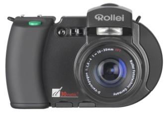
5 AIC History and Present - Rolleiflex 6008 with fixed mounted digital back with 6 MegaPixel (MP) in First use in aerial production - Modified for the airborne use - Can be combined with FMS, GPS, IMU, etc.
 -")

6 New concepts in digital aerial survey cameras the Rollei AIC (Aerial Industrial Camera) - Camera Body - Lens System - Electronics - Digital Back First versions in operation since 2004
 Forward motion is minimized with fast shutter speed - up to 1/1000 of a")
7 New concepts aerial survey cameras lenses Professional lens systems (Schneider, Zeiss) Electronic Shutter is in the lens system. Extremely low number of moving parts (~15 in shutter) Forward motion is minimized with fast shutter speed - up to 1/1000 of a second.

8 New: Precise AIC bayonet connector Stabilisation of Interior Orientation

9 The second Generation of the AIC in 2007 New professional lenses Lower Weight Smaller Design Higher Resolution Existing Systems can be upgraded Second product line beside generation one


10 The second generation of the AIC in 2007 Special lens systems for digital aerial imaging

11 Camera Calibration AIC

12 Aircraft power supply. FMS connectable IMU/GPS Serial interface (RS232) to control the camera during mission. Advanced Light Meter Unit. Mountings for existing LFC can be used. Integration with LIDAR Systems OEM Agreement with Optech (2005) TopoSys system partner (2007)
 Universal (GPS, IMU) CCNS4, Trackair etc.")
13 Open System Interfaces to all existing Systems Electronic Unit Release RS 232 (Flight Management System) (Computer) Universal (GPS, IMU) CCNS4, Trackair etc. Power (Computer/Aircraft) Auxiliary (camera connection)

14 Installed in a plane using the hole of a NT2 (Zeiss)


15 Installed in a helicopter with an Optech ALTM Lidar-System

16 RolleiMetric AIC Integration in LIDAR systems AIC Harrier 56 TopoSys LIDAR
17 From medium to LARGE with medium??? It is not an new idea or even concept It is the logical way The combination of two or more AIC cameras Possible are up to 8 cameras at the moment Synchronization time better than 200 micro sec. Image stitching software Open system with exchangeable lenses Proven technology
18 RolleiMetric AICx2 Types of sensors / digital backs (PhaseOne*) P 20 P 25 P 45 4,1 K / 4,1 K (16,8 MP) 4,1 K / 5,4 K (22,1 MP) 5,4 K / 7,2 K (39,5 MP) (36,9/36,9 mm 2, 9µm) (36,9/48,7 mm 2, 9µm) (36,9/48,7 mm 2, 6,8µm) e. g. AIC x2 ca. 5 k ca. 14 k * RolleiMetric and Phase One (Leading company in direct digital imagery) have a close co-operation in the field of metric cameras


19 RolleiMetric AICx2
.")

20 New housing for the AICx2 (multi head system).. fully integrated FMS GPS/IMU Raid/Computer Power apprx.70 (79) MP ca. 5 k ca. 14 k
21 The AICxN is designed as a multi head camera system. All parameters of each single camera are in connection to the first camera of the system. RolleiMetric defines the reference camera in the setup. For all calculations of the virtual image of an AICxN the following parameters are used: - The interior orientation of each single camera head (R0, XH, YH, A1, A2, CK) - The relative orientation between the reference camera and the others (Omega, Phi, Kappa, dx, dy, dz) - Optical properties of each camera, e.g. white balance, vignitation and others The image plane of the virtual camera will be defined by the normalenvector of the single camera image layers. n< n Cam x N = x, virt N, i xn i= 0 - Normalenvector Image plane The rotation of the virtual camera coordinate system in comparison to the single cameras will be defined by a complete rotation. R virt, i = Rvirt, ref R i The projection centre of the virtual camera is calculated as centre of gravity of the projection centres of the single cameras. x = ( n n Cam < 0, virt i= 0 x 0, i ) / n Cam n Cam Number of cameras


22

23 Stitched Image, Flight Alpha Luftbild, GSD 12 cm, AICx2, 80 mm PQS lenses

24 Stitched Image, Test Flight RolleiMetric, GSD 12 cm, AICx2, 150 mm PQS lenses, App. 15% Overlapping 13K by 5K Pixel
25 Conclusions and Prospects Medium format will enter in large format mapping camera solution The AIC is a open system with interfaces to all existing systems, e.g. GPS/IMU, FMS, Mountings The development in the medium sensor market is rising and new senors will follow soon. The price/performance ratio of a medium format camera is more attractive.

26 Thank you very much and enjoy the ongoing 51 st Photogrammetric Week
ISPRS Com1 Update Airborne Sensor Systems. Arthur Rohrbach SGPBF meeting, RSL, Fall 2006
 ISPRS Com1 Update Airborne Sensor Systems Arthur Rohrbach SGPBF meeting, RSL, Fall 2006 Significant Meetings / News (for Sensor Systems) 1/2 ASPRS, Reno, USA (May-06) Vexcel, Austria Leica, Switzerland
Trimble Geospatial Division Integrated Solutions for Geomatics professions. Volker Zirn Regional Sales Representative
 Trimble Geospatial Division Integrated Solutions for Geomatics professions Volker Zirn Regional Sales Representative 1 Agenda Trimble GeoSpatial Division Airborne System Solutions Trimble Inpho Software
SimActive and PhaseOne Workflow case study. By François Riendeau and Dr. Yuri Raizman Revision 1.0
 SimActive and PhaseOne Workflow case study By François Riendeau and Dr. Yuri Raizman Revision 1.0 Contents 1. Introduction... 2 1.1. Simactive... 2 1.2. PhaseOne Industrial... 2 2. Testing Procedure...
Remote Sensing Sensor Integration
 Remote Sensing Sensor Integration Erica Tharp LiDAR Supervisor Table of Contents About 3001 International Inc Remote Sensing Platforms Why Sensor Integration? Technical Aspects of Sensor Integration Limitations
P h a s e O n e i X U - RS A c c u r a c y A n a l y s i s. T h e f o r e f r o n t o f a e r i a l p h o t o g r a p h y
 P h a s e O n e i X U - RS1 0 0 0 A c c u r a c y A n a l y s i s T h e f o r e f r o n t o f a e r i a l p h o t o g r a p h y 1 Phase One Industrial Aerial Survey Products ixu-rs1000, ixu1000 series
MIDAS 5 Camera System. (Multi-camera Integrated Digital Acquisition System)
") MIDAS 5 Camera System (Multi-camera Integrated Digital Acquisition System) MIDAS 5 in Puppet Air STP-400 Mount The MIDAS Solution The MIDAS 5 system is a complete turn-key oblique Imaging solution for
MIDAS 5 Camera System (Multi-camera Integrated Digital Acquisition System) MIDAS 5 in Puppet Air STP-400 Mount The MIDAS Solution The MIDAS 5 system is a complete turn-key oblique Imaging solution for
Accuracy Assessment of POS AVX 210 integrated with the Phase One ixu150
 White Paper 3/17/2016 Accuracy Assessment of POS AVX 210 integrated with the Phase One ixu150 Omer Mian, Joe Hutton, Greg Lipa, James Lutes, Damir Gumerov, Srdjan Sobol Applanix, William Chan - GeoPixel
G2-AS100. Presents: A mid-format fully integrated photogrammetric camera
 Presents: G2-AS100 A mid-format fully integrated photogrammetric camera Designed and manufactured by Global Geo Supplies, Inc. Lone Tree, Colorado USA 1 TABLE OF CONTENTS CAMERA SPECIFICATIONS LENSES PERFORMANCE
ixu-rs1900 Aerial Solutions
 Aerial Solutions Seeing the Large Picture Medium Format Evolves Aerial Camera Phase One 190MP Aerial Camera series is the latest Phase One innovation to offer large format metric camera functionality.
Trimble GeoSpatial Products
 Expanding Solutions for Photogrammetric and Remote Sensing Professionals 55 th Photogrammetric Week in Stuttgart September 7 th 2015 Tobias Heuchel, Trimble Stuttgart, Germany Trimble GeoSpatial Products
AN INTEGRATED SENSOR ORIENTATION SYSTEM FOR AIRBORNE PHOTOGRAMMETRIC APPLICATIONS
 AN INTEGRATED SENSOR ORIENTATION SYSTEM FOR AIRBORNE PHOTOGRAMMETRIC APPLICATIONS M. J. Smith a, *, N. Kokkas a, D.W.G. Park b a Faculty of Engineering, The University of Nottingham, Innovation Park, Triumph
Aerial Triangulation Report 2016 City of Nanaimo Aerial Mapping Project
 Aerial Triangulation Report 2016 City of Nanaimo Aerial Mapping Project Project # 160001 Date: June 27, 2016 City of Nanaimo, 455 Wallace Street, Nanaimo, B.C., V9R 5J6 Attention: Mr. Mark Willoughby,
1. Introduction. A CASE STUDY Dense Image Matching Using Oblique Imagery Towards All-in- One Photogrammetry
 Submitted to GIM International FEATURE A CASE STUDY Dense Image Matching Using Oblique Imagery Towards All-in- One Photogrammetry Dieter Fritsch 1, Jens Kremer 2, Albrecht Grimm 2, Mathias Rothermel 1
Phase One ixa-r Camera. Fully Integrated Aerial Photography Solutions
 Phase One ixa-r Camera Fully Integrated Aerial Photography Solutions Phase One ixa-r Camera System The Phase One ixa-r aerial camera system is an integrated medium format camera system that was designed
ifp Universität Stuttgart Performance of IGI AEROcontrol-IId GPS/Inertial System Final Report
 Universität Stuttgart Performance of IGI AEROcontrol-IId GPS/Inertial System Final Report Institute for Photogrammetry (ifp) University of Stuttgart ifp Geschwister-Scholl-Str. 24 D M. Cramer: Final report
Exterior Orientation Parameters
 Exterior Orientation Parameters PERS 12/2001 pp 1321-1332 Karsten Jacobsen, Institute for Photogrammetry and GeoInformation, University of Hannover, Germany The georeference of any photogrammetric product
PHOTOGRAMMETRIC SOLUTIONS OF NON-STANDARD PHOTOGRAMMETRIC BLOCKS INTRODUCTION
 PHOTOGRAMMETRIC SOLUTIONS OF NON-STANDARD PHOTOGRAMMETRIC BLOCKS Dor Yalon Co-Founder & CTO Icaros, Inc. ABSTRACT The use of small and medium format sensors for traditional photogrammetry presents a number
Terrestrial GPS setup Fundamentals of Airborne LiDAR Systems, Collection and Calibration. JAMIE YOUNG Senior Manager LiDAR Solutions
 Terrestrial GPS setup Fundamentals of Airborne LiDAR Systems, Collection and Calibration JAMIE YOUNG Senior Manager LiDAR Solutions Topics Terrestrial GPS reference Planning and Collection Considerations
IMAGE ACQUISITION FOR DIGITAL PHOTOGRAMMETRY USING OF THE SHELF AND METRIC CAMERAS
 IMAGE ACQUISITION FOR DIGITAL PHOTOGRAMMETRY USING OF THE SHELF AND METRIC CAMERAS Günter Pomaska FH Bielefeld, University of Applied Sciences Artilleriestr. 9, D32427 Minden gp@imagefact.de, www.imagefact.de
Leica Systems Overview
 RC30 AERIAL CAMERA SYSTEM Leica Systems Overview The Leica RC30 aerial film camera is the culmination of decades of development, started with Wild's first aerial camera in the 1920s. Beautifully engineered
Datasheet. A5D Aerial. Main Features. Medium Format digital capture advantage
 A5D Aerial With its image sensor specially selected to provide the flatness required for applications such as advanced mapping, the new A5D is the ideal camera for aerial photography. The A5D also features
APPLICATION AND ACCURACY EVALUATION OF LEICA ADS40 FOR LARGE SCALE MAPPING
 APPLICATION AND ACCURACY EVALUATION OF LEICA ADS40 FOR LARGE SCALE MAPPING WenYuan Hu a, GengYin Yang b, Hui Yuan c,* a, b ShanXi Provincial Survey and Mapping Bureau, China - sxgcchy@public.ty.sx.cn c
Phase One ixa-r-180 Aerial Triangulation
 Phase One ixa-r-180 Aerial Triangulation Accuracy Assessment Results Revision 1 Oodi Menaker and Stephen Epstein Table of Contents 1. Introduction... 1 2. Method... 1 2.1. Selection of Test Area... 2 2.2.
Leica ADS80 and Leica XPro - A total solution for photogrammetric mapping
 Leica ADS80 and Leica XPro - A total solution for photogrammetric mapping Ruedi Wagner, VP Imaging, Geospatial Solutions Division Phowo 2009 - Real Geospatial Solutions What else can I do with my sensor?
ACCURACY AND RADIOMETRIC STUDY ON LATEST GENERATION LARGE FORMAT DIGITAL FRAME CAMERAS
 ACCURACY AND RADIOMETRIC STUDY ON LATEST GENERATION LARGE FORMAT DIGITAL FRAME CAMERAS Ricardo M. Passini Karsten Jacobsen David Day BAE SYTEMS-GPS Institute of Photogrammetry Keystone Aerial Surveys Leibniz
Automating Data Alignment from Multiple Collects Author: David Janssen Optech Incorporated,Senior Technical Engineer
 Automating Data Alignment from Multiple Collects Author: David Janssen Optech Incorporated,Senior Technical Engineer Stand in Presenter: David Collison Optech Incorporated, Regional Sales Manager Introduction
Phase One ixu 150 The world s smallest and lightest integrated digital medium format aerial camera
 Phase One ixu 150 The world s smallest and lightest integrated digital medium format aerial camera Phase One ixu 150 Camera System The Phase One ixu 150 camera is the smallest and lightest integrated digital
Airborne Laser Survey Systems: Technology and Applications
 Abstract Airborne Laser Survey Systems: Technology and Applications Guangping HE Lambda Tech International, Inc. 2323B Blue Mound RD., Waukesha, WI-53186, USA Email: he@lambdatech.com As mapping products
LiDAR & Orthophoto Data Report
 LiDAR & Orthophoto Data Report Tofino Flood Plain Mapping Data collected and prepared for: District of Tofino, BC 121 3 rd Street Tofino, BC V0R 2Z0 Eagle Mapping Ltd. #201 2071 Kingsway Ave Port Coquitlam,
2-in-1 Large Format and Oblique Aerial Camera Systems for 3D Urban Mapping. Philipp Grimm EUROSDR/ISPRS Workshop Oblique, Barcelona,
 2-in-1 Large Format and Oblique Aerial Camera Systems for 3D Urban Mapping Philipp Grimm EUROSDR/ISPRS Workshop Oblique, Barcelona, 09.10.2017 Mission Planning & Flight Guidance Sensor Management GNSS/IMU
Select Your Sensor. Select Your Interface. Get The Perfect Fit
 THE IMAGE YOU WANT, THE WAY YOU WANT PicSight marks an all new approach for industrial cameras. You take control! Choose your very own industrial camera to match your needs. Pick your image characteristics
MODELLING FOREST CANOPY USING AIRBORNE LIDAR DATA
 MODELLING FOREST CANOPY USING AIRBORNE LIDAR DATA Jihn-Fa JAN (Taiwan) Associate Professor, Department of Land Economics National Chengchi University 64, Sec. 2, Chih-Nan Road, Taipei 116, Taiwan Telephone:
Absolute Horizontal Accuracies of Pictometry s Individual Orthogonal Frame Imagery
 A Pictometry International, Corp White Paper Absolute Horizontal Accuracies of Pictometry s Individual Orthogonal Frame Imagery Michael J. Zoltek VP, Surveying & Mapping Pictometry International, Corp
DETERMINATION OF IMAGE ORIENTATION SUPPORTED BY IMU AND GPS
 DETERMINATION OF IMAGE ORIENTATION SUPPORTED BY IMU AND GPS Karsten Jacobsen University of Hannover Institute for Photogrammetry and Engineering Surveys Nienburger Str. 1 D-30167 Hannover Jacobsen@ipi.uni-hannover.de
Phase One ixa Camera System Fully Integrated Aerial Photography Solutions
 Phase One ixa Camera System Fully Integrated Aerial Photography Solutions Phase One ixa Camera System The Phase One ixa aerial camera system is an integrated medium format camera system that was designed
Chapters 1 9: Overview
 Chapters 1 9: Overview Chapter 1: Introduction Chapters 2 4: Data acquisition Chapters 5 9: Data manipulation Chapter 5: Vertical imagery Chapter 6: Image coordinate measurements and refinements Chapters
REMOTE SENSING LiDAR & PHOTOGRAMMETRY 19 May 2017
 REMOTE SENSING LiDAR & PHOTOGRAMMETRY 19 May 2017 SERVICES Visual Inspections Digital Terrain Models Aerial Imagery Volume Computations Thermal Inspections Photo maps Aerial Video Training & Consultancy
James Van Rens CEO Riegl USA, Inc. Mining Industry and UAV s combined with LIDAR Commercial UAV Las Vegas October 2015 James Van Rens CEO Riegl USA
 James Van Rens CEO Riegl USA, Inc. Mining Industry and UAV s combined with LIDAR Commercial UAV Las Vegas October 2015 James Van Rens CEO Riegl USA COST EFFECIENCY CONTINUUM LIDAR and IMU Partnership Technology
The IQ camera system. Unlimited creativity at your fingertips
 The IQ camera system Unlimited creativity at your fingertips I am amazed by the image quality I ve gotten out of the box with the Phase One IQ180 on the Phase One 645DF camera. I can create images with
DMC - Practical Experiences and Photogrammetric System Performance
 Photogrammetric Week '03 Dieter Fritsch (Ed.) Wichmann Verlag, Heidelberg, 2003 Dörstel 59 DMC - Practical Experiences and Photogrammetric System Performance CHRISTOPH DÖRSTEL, Z/I Imaging, Aalen ABSTRACT
Integrated Multi-Source LiDAR and Imagery
 Figure 1: AirDaC aerial scanning system Integrated Multi-Source LiDAR and Imagery The derived benefits of LiDAR scanning in the fields of engineering, surveying, and planning are well documented. It has
MicaSense RedEdge-MX TM Multispectral Camera. Integration Guide
 MicaSense RedEdge-MX TM Multispectral Camera Integration Guide Revision: 01 October 2018 MicaSense, Inc. Seattle, WA 2018 MicaSense, Inc. Page 1 of 19 TABLE OF CONTENTS Introduction and Scope 3 Camera
COMBINED BUNDLE BLOCK ADJUSTMENT VERSUS DIRECT SENSOR ORIENTATION ABSTRACT
 COMBINED BUNDLE BLOCK ADJUSTMENT VERSUS DIRECT SENSOR ORIENTATION Karsten Jacobsen Institute for Photogrammetry and Engineering Surveys University of Hannover Nienburger Str.1 D-30167 Hannover, Germany
TRAINING MATERIAL HOW TO OPTIMIZE ACCURACY WITH CORRELATOR3D
 TRAINING MATERIAL WITH CORRELATOR3D Page2 Contents 1. UNDERSTANDING INPUT DATA REQUIREMENTS... 4 1.1 What is Aerial Triangulation?... 4 1.2 Recommended Flight Configuration... 4 1.3 Data Requirements for
Chapter 1: Overview. Photogrammetry: Introduction & Applications Photogrammetric tools:
 Chapter 1: Overview Photogrammetry: Introduction & Applications Photogrammetric tools: Rotation matrices Photogrammetric point positioning Photogrammetric bundle adjustment This chapter will cover the
SC03MPC: 0.3 Mega Pixels Serial JPEG Camera Infrared User Manual. Introduction
 0.3 Mega Pixels Serial JPEG Camera Infrared SC03MPC User Manual, Rev. C For latest user manual, please visit: Introduction The SC03MPC Camera is a highly integrated serial JPEG camera module which can
Basler IP Fixed Box Cameras
 Basler IP Fixed Box Cameras NETWORK CAMERAS BIP2-1920-30c WITH SONY IMX174 SENSOR Premium image quality CCD and CMOS sensors VGA to 5 megapixels Multi-streaming and multi-encoding,, OVERVIEW Basler IP
All Surveillance Cards
 All Surveillance Cards! " # $ %& '"( # )#*+,-+-." /# 0.' +"1 +/2,*-3*4 #" & 5+-67&,&8' 9( #0 :;; ; All Surveillance Cards?@ "( #)A.B # # / +/2,*-3*#-." ;' ( B 6( ( 0 0 # #0?-; #"("( &0-+
Reality Modeling Drone Capture Guide
 Reality Modeling Drone Capture Guide Discover the best practices for photo acquisition-leveraging drones to create 3D reality models with ContextCapture, Bentley s reality modeling software. Learn the
MLX Ultra-High Sensitivity Color Camera System from NAC Image Technology. January 2005 from NAC Image Technology Page 1 of 13
 Page 1 of 13 Overview The MLX Ultra High-Sensitivity Color Camera System from NAC Image Technology is a completely new camera system using the most advanced technology. The MLX uses an advanced CCD sensor
The SC03MPA camera is capable of outputting JPEG format images and PAL/NTSC video (Video is available only per request).
.") SC03MPA: 0.3 Mega Pixels Serial JPEG Camera User Manual 0.3 Mega Pixels Serial JPEG Camera SC03MPA User Manual, Rev. D (2018) For latest user manual, please visit: Introduction The SC03MPA Camera is a
SC03MPA: 0.3 Mega Pixels Serial JPEG Camera User Manual 0.3 Mega Pixels Serial JPEG Camera SC03MPA User Manual, Rev. D (2018) For latest user manual, please visit: Introduction The SC03MPA Camera is a
DEVELOPMENT AND EVALUATION OF A MEASUREMENT AND CALCULATION MODULE FOR OFFSETS WITH RESPECT TO A STRECHED WIRE BASED ON PHOTOGRAMMETRY AT CERN
 DEVELOPMENT AND EVALUATION OF A MEASUREMENT AND CALCULATION MODULE FOR OFFSETS WITH RESPECT TO A STRECHED WIRE BASED ON PHOTOGRAMMETRY AT CERN Servet Lapardhaja NTUA Undergraduate Student 28/09/2018 Summary
Orthophotography and LiDAR Terrain Data Collection Rogue River, Oregon Final Report
 Orthophotography and LiDAR Terrain Data Collection Rogue River, Oregon Final Report Prepared by Sky Research, Inc. 445 Dead Indian Memorial Road Ashland, OR 97520 Prepared for Rogue Valley Council of Governments
Product Description. Leica RC30 Aerial Camera System. Overview
 Leica RC30 Aerial Camera System Overview The Leica RC30 is an aerial film camera system of top quality and performance, capable of acquiring the very best aerial photographs with black and white, color
New CMOS and CCD Cameras for 2013
 New CMOS and CCD Cameras for 2013 12 Megapixel CMOS Cameras with GigE New high resolution CCD cameras with Dual GigE for higher frame rate performance For pricing or further technical information, please
Overview of the Trimble TX5 Laser Scanner
 Overview of the Trimble TX5 Laser Scanner Trimble TX5 Revolutionary and versatile scanning solution Compact / Lightweight Efficient Economical Ease of Use Small and Compact Smallest and most compact 3D
INTRODUCING THE NEW TRACK AIR NANOTRACK FMS (Newly edited 14 th January 2010)
") ial INTRODUCING THE NEW TRACK AIR NANOTRACK FMS (Newly edited 14 th January 2010) The Nanotrack is a new aerial survey flight management system designed to manage the planning and acquisition of aerial
ial INTRODUCING THE NEW TRACK AIR NANOTRACK FMS (Newly edited 14 th January 2010) The Nanotrack is a new aerial survey flight management system designed to manage the planning and acquisition of aerial
Basler IP Fixed Box Cameras
 Basler IP Fixed Box Cameras NETWORK CAMERAS NEW: BIP2-1920-25c WITH SONY IMX174 SENSOR Premium image quality CCD and CMOS sensors VGA to 5 megapixels Multi-streaming and multi-encoding,, OVERVIEW Basler
Photogrammetric Performance of an Ultra Light Weight Swinglet UAV
 Photogrammetric Performance of an Ultra Light Weight Swinglet UAV J. Vallet, F. Panissod, C. Strecha, M. Tracol UAV-g 2011 - Unmanned Aerial Vehicle in Geomatics September 14-16, 2011ETH Zurich Summary
Camera Link Series SEN TECH. Camera Link Overview. Key Features. Accessories Cables (Standard to Mini) Models Sensor Resolution Frame Rate CMOS CCD
 Models Sensor Resolution Frame Rate CMOS CCD") SEN TECH Key Features 52 New! High Speed New! High Speed Kodak Sensor High Speed CCD Sensor Cube CCD Sensor Accurate Imager Alignment with Compact Precision Housing VGA ~ QSXGA Resolutions (RGB Bayer Filter)
SEN TECH Key Features 52 New! High Speed New! High Speed Kodak Sensor High Speed CCD Sensor Cube CCD Sensor Accurate Imager Alignment with Compact Precision Housing VGA ~ QSXGA Resolutions (RGB Bayer Filter)
Basler IP Fixed Box Cameras
 Basler IP Fixed Box Cameras Network Cameras NEW: Bip2-1920-30c with sony imx174 sensor Premium image quality CCD and CMOS sensors VGA to 5 megapixels Multi-streaming and multi-encoding,, Technical Details
STUDY OF THE INTEGRATION OF LIDAR AND PHOTOGRAMMETRIC DATASETS BY IN SITU CAMERA CALIBRATION AND INTEGRATED SENSOR ORIENTATION
 STUDY OF THE INTEGRATION OF LIDAR AND PHOTOGRAMMETRIC DATASETS BY IN SITU CAMERA CALIBRATION AND INTEGRATED SENSOR ORIENTATION Mitishita, E *., Costa, F., Martins, M. Geodetic Sciences Graduate Program
Trimble VISION Positions from Pictures
 Trimble VISION Positions from Pictures This session will cover What Is Trimble VISION? Trimble VISION Portfolio What Do you Need? How Does It Work & How Accurate Is It? Applications Resources Trimble VISION
OBLIQUE DIGITAL PHOTOGRAPHY SYSTEM
 TRACK'AIR B.V. ZUTPHENSTRAAT 55 7575 EJ OLDENZAAL THE NETHERLANDS Tel +31-541229030 Fax +31-541229033 LEAD AIR Inc 4009 5 th Street Suite 102 Kissimmee, Florida 34741 Tel +1 407 343 7571 Fax +1 407 343
Pike F-032. Description. Specifications. Versatile IEEE 1394b camera Advanced feature set Many variants High frame rates
 Pike F-032 Versatile IEEE 1394b camera Advanced feature set Many variants High frame rates Description Fast VGA camera, high quality, IEEE 1394b FireWire, 208 fps The Pike F-032B/C is a very fast VGA camera
THE INTERIOR AND EXTERIOR CALIBRATION FOR ULTRACAM D
 THE INTERIOR AND EXTERIOR CALIBRATION FOR ULTRACAM D K. S. Qtaishat, M. J. Smith, D. W. G. Park Civil and Environment Engineering Department, Mu ta, University, Mu ta, Karak, Jordan, 61710 khaldoun_q@hotamil.com
ICC experiences on Inertial / GPS sensor orientation. A. Baron, W.Kornus, J.Talaya Institut Cartogràfic de Catalunya, ICC
 ICC experiences on Inertial / GPS sensor orientation A. Baron, W.Kornus, J.Talaya Institut Cartogràfic de Catalunya, ICC Keywords: GPS/INS orientation, robustness Abstract In the last few years the photogrammetric
Basler IP Fixed Box Cameras
 Basler IP Fixed Box Cameras Network Cameras Premium image quality CCD and CMOS sensors VGA to 5 megapixels Multi-streaming and multi-encoding,, Overview Basler IP Fixed Box Cameras Basler's network camera
Trimble Engineering & Construction Group, 5475 Kellenburger Road, Dayton, OH , USA
 Trimble VISION Ken Joyce Martin Koehler Michael Vogel Trimble Engineering and Construction Group Westminster, Colorado, USA April 2012 Trimble Engineering & Construction Group, 5475 Kellenburger Road,
CONTENTS. Quick Start Guide V1.0
 Quick Start Guide CONTENTS 1 Introduction... 2 2 What s in the box?... 3 3 Using your buzzard multispectral sensor... 4 3.1 Overview... 4 3.2 Connecting the power / remote trigger cable... 5 3.3 Attaching
FASTCAM MC2. Benefits HIGH PERFORMANCE H.S. VIDEO SYSTEM
 FASTCAM MC2 HIGH PERFORMANCE H.S. VIDEO SYSTEM High Speed Video System developed specifically for production line and automation fault finding The FASTCAM MC2 has been designed to meet the requirements
A step by step introduction to TopoFlight
 November 20, 2014 TopoFlight_First_Steps.docx 2004057./KB/04 A step by step introduction to TopoFlight Content 1 Introduction...2 2 Creating the area of interest with GoogleEarth...2 3 Creating the TopoFlight
a Geo-Odyssey of UAS LiDAR Mapping Henno Morkel UAS Segment Specialist DroneCon 17 May 2018
 a Geo-Odyssey of UAS LiDAR Mapping Henno Morkel UAS Segment Specialist DroneCon 17 May 2018 Abbreviations UAS Unmanned Aerial Systems LiDAR Light Detection and Ranging UAV Unmanned Aerial Vehicle RTK Real-time
TopoDrone Photogrammetric Mapping Reliable, Accurate, Safe
 TopoDrone Photogrammetric Mapping Reliable, Accurate, Safe A complete solution for accurate airborne data capture and photogrammetric mapping using an unmanned aerial vehicle COST EFFICIENT SOLUTION TO
CCD and CMOS cameras. Always a new perspective. IEEE1394 Digital CCD and CMOS Camera Line SOLUTIONS THAT MEET YOUR REQUIREMENTS
 IEEE1394 Digital CCD and CMOS Camera Line Always a new perspective SOLUTIONS THAT MEET YOUR REQUIREMENTS CCD and CMOS cameras www.net-gmbh.com NEW ELECTRONIC TECHNOLOGY Product overview NET s FOculus product
Smart Systems for Aerial Survey & Mobile Mapping
 Moscow, Feb. 2013 NEWS from IGI Smart Systems for Aerial Survey & Mobile Mapping Christian Grimm IGI, 57223 Kreuztal / Germany IGI mbh Langenauer Str. 46 57223 Kreuztal, Germany www.igi.eu www.litemapper.eu
CCNS and AEROcontrol: Products for Efficient Photogrammetric Data Collection
 'Photogrammetric Week 01' D. Fritsch & R. Spiller, Eds. Wichmann Verlag, Heidelberg 2001. Kremer 85 CCNS and AEROcontrol: Products for Efficient Photogrammetric Data Collection JENS KREMER, Kreuztal ABSTRACT
Basler IP Fixed Box Cameras NETWORK CAMERAS Premium image quality CCD and CMOS sensors
 Basler IP Fixed Box Cameras NETWORK CAMERAS Premium image quality CCD and CMOS sensors VGA to 5 megapixels Multi-streaming and multi-encoding,, OVERVIEW Basler IP Fixed Box Cameras w w w.a vs up p Basler
P H A S E O N E I N D U S T R I A L. T h e w o r l d l e a d e r i n h i g h r e s o l u t i o n i m a g i n g
 P H A S E O N E I N D U S T R I A L T h e w o r l d l e a d e r i n h i g h r e s o l u t i o n i m a g i n g 1 WE ARE A WORLD LEADING PROVIDER of medium format digital imaging systems and solutions for
An Overview of Applanix.
 An Overview of Applanix The Company The Industry Leader in Developing Aided Inertial Technology Founded on Canadian Aerospace and Defense Industry Expertise Providing Precise Position and Orientation Systems
Geometry of Aerial photogrammetry. Panu Srestasathiern, PhD. Researcher Geo-Informatics and Space Technology Development Agency (Public Organization)
") Geometry of Aerial photogrammetry Panu Srestasathiern, PhD. Researcher Geo-Informatics and Space Technology Development Agency (Public Organization) Image formation - Recap The geometry of imaging system
Geometry of Aerial photogrammetry Panu Srestasathiern, PhD. Researcher Geo-Informatics and Space Technology Development Agency (Public Organization) Image formation - Recap The geometry of imaging system
MAPPS 2013 Winter Conference 2013 Cornerstone Mapping, Inc. 1
 MAPPS 2013 Winter Conference 2013 Cornerstone Mapping, Inc. 1 What is Thermal Imaging? Infrared radiation is perceived as heat Heat is a qualitative measure of temperature Heat is the transfer of energy
MicaSense RedEdge-M TM Multispectral Camera. Integration Guide
 RedEdge- M Integration Guide Rev 02 MicaSense RedEdge-M TM Multispectral Camera Integration Guide Revision: 02 November 2017 MicaSense, Inc. Seattle, WA 2017 MicaSense, Inc. Page 1 of 15 TABLE OF CONTENTS
MINOX WILDLIFE CAMERAS
 MINOX WILDLIFE CAMERAS www.minox.com MINOX WILDLIFE CAMERAS For quite some time now, wildlife cameras are being used for monitoring, recording and researching wildlife, and have become indispensable tools
New Features In TerraPhoto. What s New in Terrasolid v011? Webinar 15 February Feb 2011 What's New in Terrasolid v011? 2
 New Features In TerraPhoto What s New in Terrasolid v011? Webinar 15 February 2011 Darrick Wagg GeoCue Group 9668 Madison Blvd., Suite 202 Madison, AL 35758 +1 (256) 461-8289 support@geocue.com support.geocue.com
SC20MPC: 2 Mega Pixels Serial JPEG Camera User Manual. Introduction
 2 Mega Pixels Serial JPEG Camera SC20MPC User Manual, Rev. F (August 2018) For latest user manual, please visit: Introduction The SC20MPC Camera is a highly integrated serial JPEG camera module which can
ZENMUSE X4S. User Manual V
 ZENMUSE X4S User Manual V1.0 2016.12 Searching for Keywords Search for keywords such as battery and install to find a topic. If you are using Adobe Acrobat Reader to read this document, press Ctrl+F on
Release Notes for IDS Software Suite 4.90
 Release Notes for IDS Software Suite 4.90 Contents Introduction... 2 New products... 2 New camera families... 2 GigE ueye SE Rev. 4... 2 ueye SE USB 3.1 Gen. 1... 3 New camera models... 3 UI-3131LE VU,
Product Information Version 1.1. ZEISS Axiocam 503 mono Your Flexible and Sensitive 3 Megapixel Microscope Camera for Live Cell Imaging
 Product Information Version 1.1 ZEISS Axiocam 503 mono Your Flexible and Sensitive 3 Megapixel Microscope Camera for Live Cell Imaging ZEISS Axiocam 503 mono Sensor Model Sensor Pixel Count Pixel Size
Leica DFC3000 G. Crisp fluorescence documentation for routine experiments
 Leica DFC3000 G Crisp fluorescence documentation for routine experiments Leica DFC3000 G fluorescence documentation camera Leica DFC3000 G Crisp Fluorescence Documentation for Routine Experiments The Leica
The Applanix Approach to GPS/INS Integration
 Lithopoulos 53 The Applanix Approach to GPS/INS Integration ERIK LITHOPOULOS, Markham ABSTRACT The Position and Orientation System for Direct Georeferencing (POS/DG) is an off-the-shelf integrated GPS/inertial
Phantom v7.3. Phantom v7.3. Datasheet. Mechanical Drawing. Sensor Spectral Response 1 / 10
 Phantom v7.3 Datasheet Mechanical Drawing Sensor Spectral Response 1 / 10 {tab= Description} Our most popular camera, high speed and high sensitivity for more demanding applications - Full frame 4:3 aspect
Geometric Accuracy Assessment of Unmanned Digital Cameras and LiDAR Payloads
 Geometric Accuracy Assessment of Unmanned Digital Cameras and LiDAR Payloads Mohamed M. R. Mostafa, Stefanie Van-Wierts, and Vi Huynh Microdrones, 2911 Rue Du Meunier, Vaudreuil-Dorion, J7V 8P2 Quebec,
Camera Calibration for a Robust Omni-directional Photogrammetry System
 Camera Calibration for a Robust Omni-directional Photogrammetry System Fuad Khan 1, Michael Chapman 2, Jonathan Li 3 1 Immersive Media Corporation Calgary, Alberta, Canada 2 Ryerson University Toronto,
Lecture 11. LiDAR, RADAR
 NRMT 2270, Photogrammetry/Remote Sensing Lecture 11 Calculating the Number of Photos and Flight Lines in a Photo Project LiDAR, RADAR Tomislav Sapic GIS Technologist Faculty of Natural Resources Management
Terrasolid European Training Event
 Terrasolid European Training Event February 13 th 18 th, 2012 - Levi / Finland Nikolaus STUDNICKA Business Development Manager RIEGL Laser Measurement Systems GmbH Content Mobile Laser Scanning System
2. POINT CLOUD DATA PROCESSING
 Point Cloud Generation from suas-mounted iphone Imagery: Performance Analysis A. D. Ladai, J. Miller Towill, Inc., 2300 Clayton Road, Suite 1200, Concord, CA 94520-2176, USA - (andras.ladai, jeffrey.miller)@towill.com
Assessing the Performance of Different Direct-Georeferencing with Large Format Digital Cameras
 Assessing the Performance of Different Direct-Georeferencing with Large Format Digital Cameras Civil and Environment Engineering Department, Mu ta University, Mu ta, Al-Karak, Jordan, 61710. E.mail: khaldoun_q@hotamil.com
VISION IMPACT+ OCR HIGHLIGHTS APPLICATIONS. Lot and batch number reading. Dedicated OCR user interface. Expiration date verification
 IMPACT+ OCR IMPACT+ OCR is the new Datalogic innovative solution for robust and effective Optical Character Recognition (e.g. expiration date, lot number) for the Food & Beverage industry. The new Datalogic
Product Information Version 1.1. ZEISS Axiocam 702 mono Your 2.3 Megapixel Microscope Camera for Fast Low Light and Live Cell Imaging
 Product Information Version 1.1 ZEISS Axiocam 702 mono Your 2.3 Megapixel Microscope Camera for Fast Low Light and Live Cell Imaging ZEISS Axiocam 702 mono Sensor Model Sensor Pixel Count Pixel Size Sensor