Quality of the TanDEM-X DEM
|
|
|
- Horace Howard
- 5 years ago
- Views:
Transcription

1 Quality of the TanDEM-X DEM Manfred Zink, Markus Bachmann, Thomas Fritz, Paola Rizzoli, Daniel Schulze, Birgit Wessel CEOS SAR September 2016 Tokyo Denki University, Japan


2 TerraSAR-X-add-on for Digital Elevation Measurements Launched: 21-Jun-2010 TanDEM-X und zukünftige SAR-Missionen
3 Standards for Digital Elevation Models Spatial Resolution Absolute Vertical Accuracy (90%) Relative Vertical Accuracy (point-to-point in 1 cell, 90%) DTED-1 90 m x 90 m < 30 m < 20 m DTED-2 30 m x 30 m < 18 m < 12 m TanDEM-X 12 m x 12 m < 10 m < 2 m / 4 m * Level-4 6 m x 6 m < 5 m < 0.8 m Definition of 90% point-to-point errors: 1 1 relative height error h * slopes below/above 20% ~ 2 h absolute height error h single point errors (90% confidence interval) point-to-point errors (90% confidence interval) 90% h 2.33 h

4 Visitors Mine F60, Lichterfeld SRTM

5 Visitors Mine F60, Lichterfeld TanDEM-X

6 Key Capabilities of TanDEM-X Close Formation Flight Precise Baseline Determination 3D baseline at mm accuracies Synchronisation B 2 Calibration B 1 B BIAS Highly accurate and powerful processing chains

7 Helix Formation Slide 7

8 Bi-static Operation - Synchronisation Bi-static operation of TSX and TDX requires synchronisation of independent oscillators Phase referencing by exchange of pulses via synchronization link Leap PRIs compensate drift of Echo Window Sync Warning for mutual health check Picosecond accuracies achieved


9 TanDEM-X Global DEM Acquisition Plan Comm. Phase 1 st Global Coverage 2 nd Global Coverage Difficult Terrain & Antarctica & Gap Filling Science Phase 1 st Global Coverage Small baseline (~200 m) Height of Ambiguity ~ 50 m 3 rd Year Antarctica Difficult terrain to account for shadow & layover Different viewing geometry Deserts 2 nd Global Coverage Increased baseline (~300 m) Height of Ambiguity ~ 35 m Combination: Dual Baseline Phase Unwrapping Improved relative height accuracy 4 th Year & Beyond TanDEM-X Science Phase Local High-Resolution DEMs Global DEM improvement & Complementary products

10 Acquisition Sequence - Relative Height Error


11 Operational processing: Integrated TanDEM-X Processor (ITP) Raw DEM Scene 1 data take cut into scenes of ~50km x 30km = 1 RawDEM + 2 complex images ( = 1 CoSSC) Slide 11 Datatake


12 Radargrammetry to Resolve Phase Ambiguity Band requires delay calibration of the system to mm accuracies z slave master θ 2 θ 1 parallactic angles t sl / 2 t ma / 2 time delays in SAR = phases in InSAR P especially important in regions > 60 deg latitude where no SRTM is available A B P becoming globally independent of SRTM as reference DEM for phase unwrapping Slide 12
13 Calibration of the Interferometric System Baseline calibration to mm accuracy achieved Accurate calibration of differential delays and correction of relativistic effects enables use of radargrammetry for resolving ambiguities works for 99% of all RawDEMs Global phase constant adjusted to minimize offset w.r.t. ICESat corrected SRTM Correction of differential troposheric path delay 90% of all data within ±10 m (w.r.t. to SRTM + ICESat)

14 Absolute Height Error of Scene-Based RawDEMs First Coverage Second Coverage


15 Final DEM Adjustment using ICESat Altimeter Data Errors Corrected: - Offsets - Gradient in azimuth - Tilt in range Filtering of ICESat points (flat areas, no or low vegetation) Selected set of ca. 100 ICESat points per geocell are used for absolute calibration Remaining majority of points (> 15 Mio.) are used for validation


16 DEM Product Layer Overview DEM AMP WAM COM HEM AM2 COV LSM

17 DEM Production Status (August 30, 2016)

18 Relative Height Accuracy Confidence (%) : Tile Pct. 96,4% of Final DEMs Achieve Relative Height Accuracy Specification
19 Absolute Height Accuracy 90% Accuracy : Tile Pct. Parameter Statistic Number of Available DEM Tiles 18,630 Accumulated Number of Validation Points 15,021,838 Mean Height Deviation of Validation Points m Linear Error for Absolute Height Accuracy of 10 m 99.48% Accumulated Absolute Height Accuracy with 90% LE 3.23 m
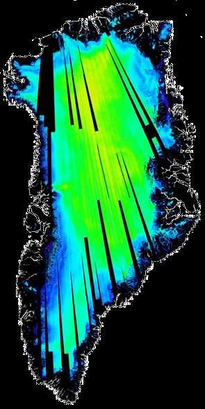


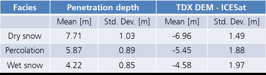
20 Penetration Depth - Greenland Ice Sheet Difference: TDX DEM - ICESat Penetration Depth [m] 12 [m] 6 0
21 Absolute Height Accuracy 90% Accuracy : Tile Pct. Parameter Statistic Number of Available DEM Tiles 18,630 Accumulated Number of Validation Points 15,021,838 Mean Height Deviation of Validation Points m Linear Error for Absolute Height Accuracy of 10 m 99.48% Accumulated Absolute Height Accuracy with 90% LE 3.23 m Accumulated Absolute Height Accuracy (without Greenland & Antarctica): 1.13 m


22 Low Signal Return Low Signal Return Data Coverage: Comparison with SRTM Rev. 1.0 Percent Invalid per Tile Percent Invalid per Tile SRTM: 3.9% TanDEM-X: 0% SRTM: 21% TanDEM-X: 0.06% N29W003: Algeria N20E051: Saudi Arabia


23 Voids Data Coverage: Comparison with SRTM Rev. 1.0 TanDEM-X SRTM 1.0 TanDEM-X TanDEM-X Data Set shows significantly less voids


24 Data Coverage TanDEM-X (Analysis ongoing) 15,292 Tiles have been analyzed covering approx 83% of Earth s land mass The TanDEM-X DEM has a 99.89% global data coverage


25 From Coherence to Forest/Non-Forest Deforestation in Amazon rainforest, Brazil [10 S, 67 W] Coherence map Forest map Brazil Forest Non-Forest Bolivia
26 TerraSAR-X/TanDEM-X Mission Status Stable operations since 2007, in close formation since Oct-2010 Outstanding calibration of the interferometric system Global TanDEM-X DEM just completed Data well within specifications Absolute height error one order of magnitude better than requirement AO for global DEM issued: Both satellites fully functioning, fuel resources for several additional years

27 Slide 27 Questions?
TANDEM-X: DEM ACQUISITION IN THE THIRD YEAR ERA
 TANDEM-X: DEM ACQUISITION IN THE THIRD YEAR ERA D. Borla Tridon, M. Bachmann, D. Schulze, C. J. Ortega Miguez, M. D. Polimeni, M. Martone and TanDEM-X Team Microwaves and Radar Institute, DLR 5 th International
DEM Processing Chain & Data Products
 DEM Processing Chain & Data Products Birgit Wessel & Mosaicking and DEM Calibration Team German Remote Sensing Data Center (DFD-DLR) TanDEM-X Science Team Meeting 2008-Nov-24 DEM Processing Chain InSAR:
Mission Status and Data Availability: TanDEM-X
 Mission Status and Data Availability: TanDEM-X Irena Hajnsek, Thomas Busche, Alberto Moreira & TanDEM-X Team Microwaves and Radar Institute, German Aerospace Center irena.hajnsek@dlr.de 26-Jan-2009 Outline
TanDEM-X Interferometric Processing Chain and SAR Products. Thomas Fritz H. Breit, M. Eineder, M. Lachaise & ITP Development Team
 TanDEM-X Interferometric Processing Chain and SAR Products Thomas Fritz H. Breit, M. Eineder, M. Lachaise & ITP Development Team TanDEM-X Science Meeting Nov. 2008 From Acquisitions to Products - The TanDEM-X
DLR Contributions to Spaceborne Polar Observing Systems - SAR
 DLR Contributions to borne Polar Observing Systems - SAR Dana Floricioiu German Aerospace Center (DLR), Earth Observation Center (EOC) Oberpfaffenhofen, Germany TerraSAR-X / TanDEM-X Timeline TSX Launch
The TanDEM-X Mission: Data Collection and Deliverables
 Photogrammetric Week '13 Dieter Fritsch (Ed.) Wichmann/VDE Verlag, Belin & Offenbach, 013 Soergel et al. 193 The TanDEM-X Mission: Data Collection and Deliverables UWE SOERGEL, KARSTEN JACOBSEN, LUKAS
VALIDATION OF A NEW 30 METER GROUND SAMPLED GLOBAL DEM USING ICESAT LIDARA ELEVATION REFERENCE DATA
 VALIDATION OF A NEW 30 METER GROUND SAMPLED GLOBAL DEM USING ICESAT LIDARA ELEVATION REFERENCE DATA M. Lorraine Tighe Director, Geospatial Solutions Intermap Session: Photogrammetry & Image Processing
TanDEM-X. Ground Segment. DEM Products Specification Document
 Page: 1 of 46 TanDEM-X Ground Segment EOC Earth Observation Center prepared: B. Wessel Date MCP Manager reviewed: T. Fritz, T. Busche, P. Rizzoli Date ITP Manager, Science Coordination Team, SEC Team approved:
INTERFEROMETRIC MULTI-CHROMATIC ANALYSIS OF HIGH RESOLUTION X-BAND DATA
 INTERFEROMETRIC MULTI-CHROMATIC ANALYSIS OF HIGH RESOLUTION X-BAND DATA F. Bovenga (1), V. M. Giacovazzo (1), A. Refice (1), D.O. Nitti (2), N. Veneziani (1) (1) CNR-ISSIA, via Amendola 122 D, 70126 Bari,
for forest/non-forest classification from TanDEM-X interferometric Data by means of Multiple Fuzzy Clustering
 Forest/Non-Forest Classification from TanDEM-X Interferometric Data by means of Multiple Fuzzy Clustering Michele Martone, Paola Rizzoli, Benjamin Bräutigam, Gerhard Krieger Microwaves and Radar Institute,
Ship Detection and Motion Parameter Estimation with TanDEM-X in Large Along-Track Baseline Configuration
 Ship Detection and Motion Parameter Estimation with TanDEM-X in Large Along-Track Baseline Configuration SEASAR 2012 Workshop, 20.06.2012 Stefan V. Baumgartner, Gerhard Krieger Microwaves and Radar Institute,
InSAR Operational and Processing Steps for DEM Generation
 InSAR Operational and Processing Steps for DEM Generation By F. I. Okeke Department of Geoinformatics and Surveying, University of Nigeria, Enugu Campus Tel: 2-80-5627286 Email:francisokeke@yahoo.com Promoting
Repeat-pass SAR Interferometry Experiments with Gaofen-3: A Case Study of Ningbo Area
 Repeat-pass SAR Interferometry Experiments with Gaofen-3: A Case Study of Ningbo Area Tao Zhang, Xiaolei Lv, Bing Han, Bin Lei and Jun Hong Key Laboratory of Technology in Geo-spatial Information Processing
Interferometric processing. Rüdiger Gens
 Rüdiger Gens Why InSAR processing? extracting three-dimensional information out of a radar image pair covering the same area digital elevation model change detection 2 Processing chain 3 Processing chain
fraction of Nyquist
 differentiator 4 2.1.2.3.4.5.6.7.8.9 1 1 1/integrator 5.1.2.3.4.5.6.7.8.9 1 1 gain.5.1.2.3.4.5.6.7.8.9 1 fraction of Nyquist Figure 1. (top) Transfer functions of differential operators (dotted ideal derivative,
Interferometric Evaluation of Sentinel-1A TOPS data
 Interferometric Evaluation of Sentinel-1A TOPS data N. Yague-Martinez, F. Rodriguez Gonzalez, R. Brcic, R. Shau Remote Sensing Technology Institute. DLR, Germany ESTEC/Contract No. 4000111074/14/NL/MP/lf
NEXTMap World 30 Digital Surface Model
 NEXTMap World 30 Digital Surface Model Intermap Technologies, Inc. 8310 South Valley Highway, Suite 400 Englewood, CO 80112 083013v3 NEXTMap World 30 (top) provides an improvement in vertical accuracy
ALOS PALSAR. Orthorectification Tutorial Issued March 2015 Updated August Luis Veci
 ALOS PALSAR Orthorectification Tutorial Issued March 2015 Updated August 2016 Luis Veci Copyright 2015 Array Systems Computing Inc. http://www.array.ca/ http://step.esa.int ALOS PALSAR Orthorectification
Sentinel-1 Toolbox. Offset Tracking Tutorial Issued August Jun Lu Luis Veci
 Sentinel-1 Toolbox Offset Tracking Tutorial Issued August 2016 Jun Lu Luis Veci Copyright 2016 Array Systems Computing Inc. http://www.array.ca/ http://step.esa.int Offset Tracking Tutorial The goal of
WORLDDEM A NOVEL GLOBAL FOUNDATION LAYER
 WORLDDEM A NOVEL GLOBAL FOUNDATION LAYER G. Riegler, S. D. Hennig, M. Weber Airbus Defence and Space GEO-Intelligence, 88039 Friedrichshafen, Germany - (gertrud.riegler, simon.hennig, marco.weber)@astrium.eads.net
ALOS-2 PALSAR-2 support in GAMMA Software
 ALOS-2 PALSAR-2 support in GAMMA Software Urs Wegmüller, Charles Werner, Andreas Wiesmann, Gamma Remote Sensing AG CH-3073 Gümligen, http://www.gamma-rs.ch 11-Sep-2014 1. Introduction JAXA has made available
In addition, the image registration and geocoding functionality is also available as a separate GEO package.
 GAMMA Software information: GAMMA Software supports the entire processing from SAR raw data to products such as digital elevation models, displacement maps and landuse maps. The software is grouped into
IMPROVING DEMS USING SAR INTERFEROMETRY. University of British Columbia. ABSTRACT
 IMPROVING DEMS USING SAR INTERFEROMETRY Michael Seymour and Ian Cumming University of British Columbia 2356 Main Mall, Vancouver, B.C.,Canada V6T 1Z4 ph: +1-604-822-4988 fax: +1-604-822-5949 mseymour@mda.ca,
TerraS ar-x / T ande M-X Capabilities & Utility
 TerraS ar-x / T ande M-X Capabilities & Utility Dr. Oliver Lang Infoterra Germany Astrium Services GEO-Information Services Mailing: 88039 Friedrichshafen Germany Tel +49-7545-8-5520 Fax +49 7545-8-1337
SAR Interferometry. Dr. Rudi Gens. Alaska SAR Facility
 SAR Interferometry Dr. Rudi Gens Alaska SAR Facility 2 Outline! Relevant terms! Geometry! What does InSAR do?! Why does InSAR work?! Processing chain " Data sets " Coregistration " Interferogram generation
PolSARpro v4.03 Forest Applications
 PolSARpro v4.03 Forest Applications Laurent Ferro-Famil Lecture on polarimetric SAR Theory and applications to agriculture & vegetation Thursday 19 April, morning Pol-InSAR Tutorial Forest Application
First TOPSAR image and interferometry results with TerraSAR-X
 First TOPSAR image and interferometry results with TerraSAR-X A. Meta, P. Prats, U. Steinbrecher, R. Scheiber, J. Mittermayer DLR Folie 1 A. Meta - 29.11.2007 Introduction Outline TOPSAR acquisition mode
The 2017 InSAR package also provides support for the generation of interferograms for: PALSAR-2, TanDEM-X
 Technical Specifications InSAR The Interferometric SAR (InSAR) package can be used to generate topographic products to characterize digital surface models (DSMs) or deformation products which identify
PSI Precision, accuracy and validation aspects
 PSI Precision, accuracy and validation aspects Urs Wegmüller Charles Werner Gamma Remote Sensing AG, Gümligen, Switzerland, wegmuller@gamma-rs.ch Contents Aim is to obtain a deeper understanding of what
THE HIGH flexibility of the TerraSAR-X (TSX) instrument
 instrument") 614 IEEE GEOSCIENCE AND REMOTE SENSING LETTERS, VOL. 9, NO. 4, JULY 2012 Scalloping Correction in TOPS Imaging Mode SAR Data Steffen Wollstadt, Pau Prats, Member, IEEE, Markus Bachmann, Josef Mittermayer,
614 IEEE GEOSCIENCE AND REMOTE SENSING LETTERS, VOL. 9, NO. 4, JULY 2012 Scalloping Correction in TOPS Imaging Mode SAR Data Steffen Wollstadt, Pau Prats, Member, IEEE, Markus Bachmann, Josef Mittermayer,
Terrain correction. Backward geocoding. Terrain correction and ortho-rectification. Why geometric terrain correction? Rüdiger Gens
 Terrain correction and ortho-rectification Terrain correction Rüdiger Gens Why geometric terrain correction? Backward geocoding remove effects of side looking geometry of SAR images necessary step to allow
Sentinel-1 Toolbox. TOPS Interferometry Tutorial Issued May 2014
 Sentinel-1 Toolbox TOPS Interferometry Tutorial Issued May 2014 Copyright 2015 Array Systems Computing Inc. http://www.array.ca/ https://sentinel.esa.int/web/sentinel/toolboxes Interferometry Tutorial
Experimental Radar Modes with TerraSAR-X and TanDEM-X
 Experimental Radar Modes with TerraSAR-X and TanDEM-X U. Steinbrecher 1, S. Baumgartner 1, S. Suchandt 2, S. Wollstadt 1, J. Mittermayer 1, R. Scheiber 1, D. Schulze 1, H. Breit 2 1 German Aerospace Center
NEXTMap World 10 Digital Elevation Model
 NEXTMap Digital Elevation Model Intermap Technologies, Inc. 8310 South Valley Highway, Suite 400 Englewood, CO 80112 10012015 NEXTMap (top) provides an improvement in vertical accuracy and brings out greater
Do It Yourself 8. Polarization Coherence Tomography (P.C.T) Training Course
 Training Course") Do It Yourself 8 Polarization Coherence Tomography (P.C.T) Training Course 1 Objectives To provide a self taught introduction to Polarization Coherence Tomography (PCT) processing techniques to enable
Do It Yourself 8 Polarization Coherence Tomography (P.C.T) Training Course 1 Objectives To provide a self taught introduction to Polarization Coherence Tomography (PCT) processing techniques to enable
DIGITAL ELEVATION MODEL GENERATION FROM INTERFEROMETRIC SYNTHETIC APERTURE RADAR USING MULTI-SCALE METHOD
 DIGITAL ELEVATION MODEL GENERATION FROM INTERFEROMETRIC SYNTHETIC APERTURE RADAR USING MULTI-SCALE METHOD Jung Hum Yu 1, Linlin Ge, Chris Rizos School of Surveying and Spatial Information Systems University
Synthetic Aperture Radar Interferometry (InSAR)
") CEE 6100 / CSS 6600 Remote Sensing Fundamentals 1 Synthetic Aperture Radar Interferometry (InSAR) Adapted from and the ESA Interferometric SAR overview by Rocca et al. http://earth.esa.int/workshops/ers97/program-details/speeches/rocca-et-al/
CEE 6100 / CSS 6600 Remote Sensing Fundamentals 1 Synthetic Aperture Radar Interferometry (InSAR) Adapted from and the ESA Interferometric SAR overview by Rocca et al. http://earth.esa.int/workshops/ers97/program-details/speeches/rocca-et-al/
WorldDEM Technical Product Specification
 Technical Product Specification Digital Surface Model, Digital Terrain Model Version 2.0 Airbus Defence and Space Geo-Intelligence Programme Line Table of Contents Table of Contents... 2 List of Figures...
Interferometry Module for Digital Elevation Model Generation
 Interferometry Module for Digital Elevation Model Generation In order to fully exploit processes of the Interferometry Module for Digital Elevation Model generation, the European Space Agency (ESA) has
WorldDEM Technical Product Specification
 Technical Product Specification Digital Surface Model, Digital Terrain Model Version 2.4 Airbus Defence and Space Intelligence Table of Contents Table of Contents... 2 List of Figures... 4 List of Tables...
InSAR DEM; why it is better?
 InSAR DEM; why it is better? What is a DEM? Digital Elevation Model (DEM) refers to the process of demonstrating terrain elevation characteristics in 3-D space, but very often it specifically means the
CHARACTERISTICS OF WORLDWIDE AND NEARLY WORLDWIDE HEIGHT MODELS
 CHARACTERISTICS OF WORLDWIDE AND NEARLY WORLDWIDE HEIGHT MODELS Karsten Jacobsen Leibniz University Hannover, Institute of Photogrammetry and Geoinformation, Germany; jacobsen@ipi.uni-hannover.de ISPRS
Sentinel-1 Toolbox. Interferometry Tutorial Issued March 2015 Updated August Luis Veci
 Sentinel-1 Toolbox Interferometry Tutorial Issued March 2015 Updated August 2016 Luis Veci Copyright 2015 Array Systems Computing Inc. http://www.array.ca/ http://step.esa.int Interferometry Tutorial The
Chalmers Publication Library
 Chalmers Publication Library Mapping Topography and Forest Parameters in a Boreal Forest with Dual-Baseline TanDEM-X Data and the Two-Level Model This document has been downloaded from Chalmers Publication
The Staggered SAR Concept: Imaging a Wide Continuous Swath with High Resolution
 The Staggered SAR Concept: Imaging a Wide Continuous Swath with High Resolution Michelangelo Villano *, Gerhard Krieger *, Alberto Moreira * * German Aerospace Center (DLR), Microwaves and Radar Institute
MULTI-TEMPORAL INTERFEROMETRIC POINT TARGET ANALYSIS
 MULTI-TEMPORAL INTERFEROMETRIC POINT TARGET ANALYSIS U. WEGMÜLLER, C. WERNER, T. STROZZI, AND A. WIESMANN Gamma Remote Sensing AG. Thunstrasse 130, CH-3074 Muri (BE), Switzerland wegmuller@gamma-rs.ch,
Terrafirma: a Pan-European Terrain motion hazard information service.
 Terrafirma: a Pan-European Terrain motion hazard information service www.terrafirma.eu.com The Future of Terrafirma - Wide Area Product Nico Adam and Alessandro Parizzi DLR Oberpfaffenhofen Terrafirma
Sentinel-1 InSAR AP workshop
 Sentinel-1 InSAR AP workshop Sentinel-1 InSAR progress and experience at GAMMA U. Wegmüller, C. Werner, A. Wiesmann, T. Strozzi Gamma Remote Sensing AG - Progress made since S1A Expert Users meeting at
Operational process interferometric for the generation of a digital model of ground Applied to the couple of images ERS-1 ERS-2 to the area of Algiers
 Operational process interferometric for the generation of a digital model of ground Applied to the couple of images ERS-1 ERS-2 to the area of Algiers F. Hocine, M.Ouarzeddine, A. elhadj-aissa,, M. elhadj-aissa,,
Signal Processing Laboratory
 C.S.L Liege Science Park Avenue du Pré-Aily B-4031 ANGLEUR Belgium Tel: +32.4.382.46.00 Fax: +32.4.367.56.13 Signal Processing Laboratory Anne Orban VITO June 16, 2011 C. Barbier : the team Remote Sensing
Geometric Accuracy Evaluation, DEM Generation and Validation for SPOT-5 Level 1B Stereo Scene
 Geometric Accuracy Evaluation, DEM Generation and Validation for SPOT-5 Level 1B Stereo Scene Buyuksalih, G.*, Oruc, M.*, Topan, H.*,.*, Jacobsen, K.** * Karaelmas University Zonguldak, Turkey **University
TanDEM-X Pol-InSAR Inversion for Mangroves of East Africa
 TanDEM-X Pol-InSAR Inversion for Mangroves of East Africa Seung-Kuk Lee, Temilola Fatoyinbo, David Lagomasino, Batuhan Osmanoglu, Carl Trettin, Marc Simard NASA/Goddard Space Flight Center Biospheric Sciences
A Comparison of ALOS PALSAR-2 Calibration Data by Using External DEM
 CEOS SAR Calibration and Validation Workshop 2016 A Comparison of ALOS PALSAR-2 Calibration Data by Using External DEM Tokyo Denki University, Japan, 7 th -9 th September 2016 *Choen KIM College of Forest
Coherence Based Polarimetric SAR Tomography
 I J C T A, 9(3), 2016, pp. 133-141 International Science Press Coherence Based Polarimetric SAR Tomography P. Saranya*, and K. Vani** Abstract: Synthetic Aperture Radar (SAR) three dimensional image provides
InSAR Data Coherence Estimation Using 2D Fast Fourier Transform
 InSAR Data Coherence Estimation Using 2D Fast Fourier Transform Andrey V. Sosnovsky 1, Viktor G. Kobernichenko 1, Nina S. Vinogradova 1, Odhuu Tsogtbaatar 1,2 1 Ural Federal University, Yekaterinburg,
Motion compensation and the orbit restitution
 InSA R Contents Introduction and objectives Pi-SAR Motion compensation and the orbit restitution InSAR algorithm DEM generation Evaluation Conclusion and future work Introduction and Objectives L-band
FIRST RESULTS OF THE ALOS PALSAR VERIFICATION PROCESSOR
 FIRST RESULTS OF THE ALOS PALSAR VERIFICATION PROCESSOR P. Pasquali (1), A. Monti Guarnieri (2), D. D Aria (3), L. Costa (3), D. Small (4), M. Jehle (4) and B. Rosich (5) (1) sarmap s.a., Cascine di Barico,
GAMMA Interferometric Point Target Analysis Software (IPTA): Users Guide
: Users Guide") GAMMA Interferometric Point Target Analysis Software (IPTA): Users Guide Contents User Handbook Introduction IPTA overview Input data Point list generation SLC point data Differential interferogram point
GAMMA Interferometric Point Target Analysis Software (IPTA): Users Guide Contents User Handbook Introduction IPTA overview Input data Point list generation SLC point data Differential interferogram point
APPLYING TERRAIN AND HYDROLOGICAL EDITING TO TANDEM-X DATA TO CREATE A CONSUMER-READY WORLDDEM PRODUCT
 APPLYING TERRAIN AND HYDROLOGICAL EDITING TO TANDEM-X DATA TO CREATE A CONSUMER-READY WORLDDEM PRODUCT J. Collins, Dr. G. Riegler, H. Schrader, M. Tinz Airbus Defence and Space, Geo-Intelligence (john.collins@airbus.com)
RADARGRAMMETRY AND INTERFEROMETRY SAR FOR DEM GENERATION
 RADARGRAMMETRY AND INTERFEROMETRY SAR FOR DEM GENERATION Jung Hum Yu 1, Xiaojing Li, Linlin Ge, and Hsing-Chung Chang School of Surveying and Spatial Information Systems University of New South Wales,
ALOS PALSAR SCANSAR INTERFEROMETRY AND ITS APPLICATION IN WENCHUAN EARTHQUAKE
 ALOS PALSAR SCANSAR INTERFEROMETRY AND ITS APPLICATION IN WENCHUAN EARTHQUAKE Cunren Liang (1) (2), Qiming Zeng (1) (2), Jianying Jia (1) (2), Jian Jiao (1) (2), Xiai Cui (1) (2) (1) (2), Xiao Zhou (1)
Calculation of beta naught and sigma naught for TerraSAR-X data
 Calculation of beta naught and sigma naught for TerraSAR-X data 1 Introduction The present document describes the successive steps of the TerraSAR-X data absolute calibration. Absolute calibration allows
SEA SURFACE SPEED FROM TERRASAR-X ATI DATA
 SEA SURFACE SPEED FROM TERRASAR-X ATI DATA Matteo Soccorsi (1) and Susanne Lehner (1) (1) German Aerospace Center, Remote Sensing Technology Institute, 82234 Weßling, Germany, Email: matteo.soccorsi@dlr.de
TerraSAR-X Applications Guide
 TerraSAR-X Applications Guide Extract: Digital Elevation Models April 2015 Airbus Defence and Space Geo-Intelligence Programme Line Digital Elevation Models Issue Digital Elevation Models (DEM) are used
I-PAF SRTM X-SAR Processing Chain: Algorithms and Analysis of First Results
 I-PAF SRTM X-SAR Processing Chain: Algorithms and Analysis of First Results P. AMMENDOLA(*), E. LOPINTO(**),C. MARZO (***), G. MILILLO (***), G. RICCOBONO (***), G. R. VERDONE (**), R. VIGGIANO (**) (*)ASI
Scene Matching on Imagery
 Scene Matching on Imagery There are a plethora of algorithms in existence for automatic scene matching, each with particular strengths and weaknesses SAR scenic matching for interferometry applications
DEFORMATION MONITORING USING INSAR AND ARTIFICIAL REFLECTORS
 DEFORMATION MONITORING USING INSAR AND ARTIFICIAL REFLECTORS Ivana, HLAVÁČOVÁ 1, Lena, HALOUNOVÁ 1, Květoslava, SVOBODOVÁ 1 1 Department of Mapping and Cartography, Faculty of Civil Engineering, Czech
Ground Subsidence Monitored by L-band Satellite Radar. Interferometry
 Ground Subsidence Monitored by L-band Satellite Radar Interferometry Hsing-Chung Chang, Ming-han Chen, Lijiong Qin, Linlin Ge and Chris Rizos Satellite Navigation And Positioning Group School of Surveying
Interferometry Tutorial with RADARSAT-2 Issued March 2014 Last Update November 2017
 Sentinel-1 Toolbox with RADARSAT-2 Issued March 2014 Last Update November 2017 Luis Veci Copyright 2015 Array Systems Computing Inc. http://www.array.ca/ http://step.esa.int with RADARSAT-2 The goal of
A Correlation Test: What were the interferometric observation conditions?
 A Correlation Test: What were the interferometric observation conditions? Correlation in Practical Systems For Single-Pass Two-Aperture Interferometer Systems System noise and baseline/volumetric decorrelation
PROBLEMS AND SOLUTIONS FOR INSAR DIGITAL ELEVATION MODEL GENERATION OF MOUNTAINOUS TERRAIN. M. Eineder
 PROBLEMS AND SOLUTIONS FOR INSAR DIGITAL ELEVATION MODEL GENERATION OF MOUNTAINOUS TERRAIN M. Eineder German Aerospace Center (DLR), Oberpfaffenhofen, D-82234 Wessling, Germany, Email: Michael.Eineder@dlr.de
Lateral Ground Movement Estimation from Space borne Radar by Differential Interferometry.
 Lateral Ground Movement Estimation from Space borne Radar by Differential Interferometry. Abstract S.Sircar 1, 2, C.Randell 1, D.Power 1, J.Youden 1, E.Gill 2 and P.Han 1 Remote Sensing Group C-CORE 1
COSMO SkyMed Constellation
 COSMO SkyMed Constellation The driving Mission requirements for the constellation development are the following: Capability to serve at the same time both civil and military users through a integrated
Generate Glacier Velocity Maps with the Sentinel-1 Toolbox
 Making remote-sensing data accessible since 1991 Generate Glacier Velocity Maps with the Sentinel-1 Toolbox Adapted from the European Space Agency s STEP community platform In this document you will find:
2-PASS DIFFERENTIAL INTERFEROMETRY IN THE AREA OF THE SLATINICE ABOVE- LEVEL DUMP. Milan BOŘÍK 1
 2-PASS DIFFERENTIAL INTERFEROMETRY IN THE AREA OF THE SLATINICE ABOVE- LEVEL DUMP Milan BOŘÍK 1 1 Department of Mathematics, Faculty of Civil Engineering, Czech Technical University in Prague, Thákurova
SENTINEL-1 Toolbox. SAR Basics Tutorial Issued March 2015 Updated August Luis Veci
 SENTINEL-1 Toolbox SAR Basics Tutorial Issued March 2015 Updated August 2016 Luis Veci Copyright 2015 Array Systems Computing Inc. http://www.array.ca/ http://step.esa.int SAR Basics Tutorial The goal
Estimation of building heights from high-resolution
 DLR - IRIDeS - UN-SPIDER Joint Workshop on Remote Sensing and Multi-Risk Modeling for Disaster Management 19 and 20 September 2014 at UN-SPIDER Bonn Office Estimation of building heights from high-resolution
Combination of GNSS and InSAR for Future Australian Datums
 Combination of GNSS and InSAR for Future Australian Datums Thomas Fuhrmann, Matt Garthwaite, Sarah Lawrie, Nick Brown Interferometric Synthetic Aperture Radar Motivation Current situation Static Datum:
SNAP-Sentinel-1 in a Nutshell
 SNAP-Sentinel-1 in a Nutshell Dr. Andrea Minchella 1 st ESA Advanced Training Course on Remote Sensing of the Cryosphere 13 September 2016, University of Leeds, Leeds, UK What is SNAP? Credit: SNAP The
Playa del Rey, California InSAR Ground Deformation Monitoring
 Playa del Rey, California InSAR Ground Deformation Monitoring Master Document Ref.: RV-14524 July 13, 2009 SUBMITTED TO: ATTN: Mr. Rick Gailing Southern California Gas Company 555 W. Fifth Street (Mail
Upcoming altimeter measurements : nadir altimetry from Ku/C to Ka-band, SAR mode, interferometric SAR
 Upcoming altimeter measurements : nadir altimetry from Ku/C to Ka-band, SAR mode, interferometric SAR Jean-Claude Souyris CNES, Service Altimétrie & Radar Acknowledgments : Nathalie Steunou, Roger Fjortoft,
DERIVATION of the BACKSCATTERING COEFFICIENT σ o in ESA ERS SAR PRI PRODUCTS
 ERS SAR CALIBRATION DERIVATION of the BACKSCATTERING COEFFICIENT σ o in ESA ERS SAR PRI PRODUCTS H. Laur 1, P. Bally 2, P. Meadows 3, J. Sanchez 4, B. Schaettler 5, E. Lopinto 6, D. Esteban 4 Document
Improving wide-area DEMs through data fusion - chances and limits
 Improving wide-area DEMs through data fusion - chances and limits Konrad Schindler Photogrammetry and Remote Sensing, ETH Zürich How to get a DEM for your job? for small projects (or rich people) contract
ENVI Automated Image Registration Solutions
 ENVI Automated Image Registration Solutions Xiaoying Jin Harris Corporation Table of Contents Introduction... 3 Overview... 4 Image Registration Engine... 6 Image Registration Workflow... 8 Technical Guide...
DETECTION AND QUANTIFICATION OF ROCK GLACIER. DEFORMATION USING ERS D-InSAR DATA
 DETECTION AND QUANTIFICATION OF ROCK GLACIER DEFORMATION USING ERS D-InSAR DATA Lado W. Kenyi 1 and Viktor Kaufmann 2 1 Institute of Digital Image Processing, Joanneum Research Wastiangasse 6, A-8010 Graz,
APPLICATION OF SAR INTERFEROMETRIC TECHNIQUES FOR SURFACE DEFORMATION MONITORING
 APPLICATION OF SAR INTERFEROMETRIC TECHNIQUES FOR SURFACE DEFORMATION MONITORING Urs Wegmüller, Charles Werner, Tazio Strozzi, and Andreas Wiesmann Gamma Remote Sensing, Worbstrasse 225, 3073 Gümligen,
Combining Airborne LIDAR and Satellite RADAR for a Dynamic DEM. Ramon Hanssen, Delft University of Technology
 Combining Airborne LIDAR and Satellite RADAR for a Dynamic DEM Ramon Hanssen, Delft University of Technology 1 Release 27 September 2 Land surface elevation H(t) = H(t 0 ) + dh(dt) dt Elevation at time
An Introduction to Lidar & Forestry May 2013
 An Introduction to Lidar & Forestry May 2013 Introduction to Lidar & Forestry Lidar technology Derivatives from point clouds Applied to forestry Publish & Share Futures Lidar Light Detection And Ranging
Hillshade Example. Custom product generation with elevation data
 Hillshade Example Custom product generation with elevation data Version 1.0 Mark Lucas 22 May 2005 Overview Performing Artificial Shading based on Elevation OSSIM and ImageLinker provide many capabilities
Ice surface velocities using SAR
 Ice surface velocities using SAR Thomas Schellenberger, PhD ESA Cryosphere Remote Sensing Training Course 2018 UNIS Longyearbyen, Svalbard 12 th June 2018 thomas.schellenberger@geo.uio.no Outline Synthetic
WIDE AREA DEFORMATION MAP GENERATION WITH TERRASAR-X DATA: THE TOHOKU-OKI EARTHQUAKE 2011 CASE
 WIDE AREA DEFORMATION MAP GENERATION WITH TERRASAR-X DATA: THE TOHOKU-OKI EARTHQUAKE 2011 CASE Nestor Yague-Martinez (1), Michael Eineder (2), Christian Minet (2), Birgitt Schättler (2) (1) Starlab Barcelona
Airborne Laser Scanning: Remote Sensing with LiDAR
 Airborne Laser Scanning: Remote Sensing with LiDAR ALS / LIDAR OUTLINE Laser remote sensing background Basic components of an ALS/LIDAR system Two distinct families of ALS systems Waveform Discrete Return
VOID FILL OF SRTM ELEVATION DATA - PRINCIPLES, PROCESSES AND PERFORMANCE INTRODUCTION
 VOID FILL OF SRTM ELEVATION DATA - PRINCIPLES, PROCESSES AND PERFORMANCE Steve Dowding, Director, NEXTMap Products Division Trina Kuuskivi, SRTM Quality Manager Xiaopeng Li, Ph.D., Mapping Scientist Intermap
LONG-TERM SUBSIDENCE MONITORING OF CITY AREAS AT NORDIC LATITUDES USING ERS SAR DATA
 LONG-TERM SUBSIDENCE MONITORING OF CITY AREAS AT NORDIC LATITUDES USING ERS SAR DATA Tom R. Lauknes (1,2), Geir Engen (1), Kjell A. Høgda (1), Inge Lauknes (1), Torbjørn Eltoft (2), Dan J. Weydahl (3)
Interferometric SAR Processing
 Documentation - Theory Interferometric SAR Processing Version 1.0 November 2007 GAMMA Remote Sensing AG, Worbstrasse 225, CH-3073 Gümligen, Switzerland tel: +41-31-951 70 05, fax: +41-31-951 70 08, email:
Mac OSX The software in this version has been compiled again using Snow Leopard 10.6 with 64-bits.
 Release Notes GAMMA Software, 20131205 (Urs Wegmüller, Charles Werner, 5-Dec-2013) Gamma Remote Sensing AG Worbstrasse 225, CH-3073 Gümligen http://www.gamma-rs.ch This information is provided to users
PROBLEMS AND LIMITATIONS OF SATELLITE IMAGE ORIENTATION FOR DETERMINATION OF HEIGHT MODELS
 PROBLEMS AND LIMITATIONS OF SATELLITE IMAGE ORIENTATION FOR DETERMINATION OF HEIGHT MODELS K. Jacobsen Institute of Photogrammetry and GeoInformation, Leibniz University Hannover, Germany jacobsen@ipi.uni-hannover.de
TECHNICAL ASPECTS OF ENVISAT ASAR GEOCODING CAPABILITY AT DLR
 TECHNICAL ASPECTS OF ENVISAT ASAR GEOCODING CAPABILITY AT DLR Martin Huber¹, Wolfgang Hummelbrunner², Johannes Raggam², David Small³, Detlev Kosmann¹ ¹ DLR, German Remote Sensing Data Center, Oberpfaffenhofen,
Status of MOLI development MOLI (Multi-footprint Observation Lidar and Imager)
") Status of MOLI development MOLI (Multi-footprint Observation Lidar and Imager) Tadashi IMAI, Daisuke SAKAIZAWA, Jumpei MUROOKA, Rei Mitsuhashi and Toshiyoshi KIMURA JAXA 0 Outline of This Presentation
Status of MOLI development MOLI (Multi-footprint Observation Lidar and Imager) Tadashi IMAI, Daisuke SAKAIZAWA, Jumpei MUROOKA, Rei Mitsuhashi and Toshiyoshi KIMURA JAXA 0 Outline of This Presentation
Airborne Differential SAR Interferometry: First Results at L-Band
 1516 IEEE TRANSACTIONS ON GEOSCIENCE AND REMOTE SENSING, VOL. 41, NO. 6, JUNE 2003 Airborne Differential SAR Interferometry: First Results at L-Band Andreas Reigber, Member, IEEE, and Rolf Scheiber Abstract