SAR Interferometry. Dr. Rudi Gens. Alaska SAR Facility
|
|
|
- Amie Taylor
- 6 years ago
- Views:
Transcription
1 SAR Interferometry Dr. Rudi Gens Alaska SAR Facility
2 2 Outline! Relevant terms! Geometry! What does InSAR do?! Why does InSAR work?! Processing chain " Data sets " Coregistration " Interferogram generation " Phase unwrapping " Conversion from phase to height " Geocoding! Applications
3 Relevant terms! amplitude " measure of the strength of the signal! phase " angle of a complex number 3

4 Relevant terms! baseline " separation between the two antenna positions either mounted on an aircraft or realized by two repeating satellite orbits Source: Gens and van Genderen, IJRS,

5 Relevant terms! fringe " represents the whole range of the phase in an interferogram from 0 to 2π in a full color cycle 5
6 6 Geometry of SAR interferometry z
7 What does InSAR do?! extracting three-dimensional information out of a radar image pair covering the same area " digital elevation model " change detection 7
8 Why does InSAR work?! coherent signal " single frequency and phase! same geometry covering the same area from slightly different position in space 8
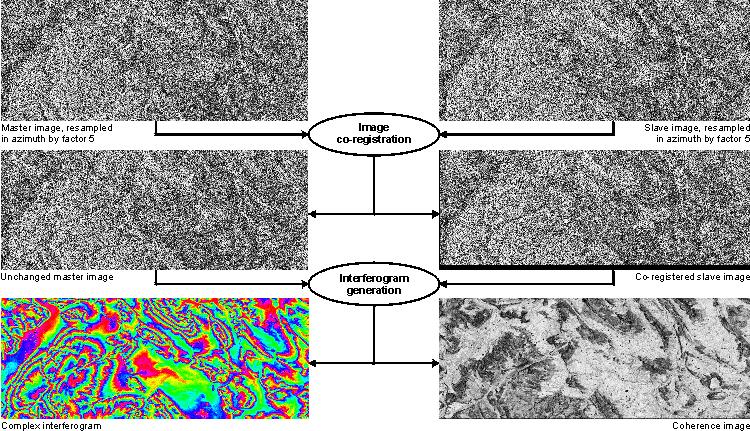
9 Processing chain 9
10 Processing chain 10
11 Data sets! satellite data " ERS-1, ERS-2, RADARSAT-1, ENVISAT (C-band) " JERS-1 (L-band)! airborne data " AirSAR, TOPSAR (research) " E-SAR, DOSAR, Star3i (commercial)! shuttle " SIR-C / X-SAR mission (NASA + DLR) " Shuttle Radar Topography Mission (SRTM) 11
12 Coregistration! alignment of master and slave image! trade off between processing time and accuracy of technique applied! coarse coregistration " matching images on a pixel level (shift in x and y)! fine coregistration " sub-pixel alignment of images " large variety of techniques 12
13 Coregistration! quality requirement to avoid phase errors ⅛ of a pixel! interpolation method " nearest neighbor, bilinear, cubic splines, sinc! quality measure: coherence 13

14 Coherence image "measure for the correlation of corresponding signals "ranges from 0 to 1 14
15 15 Interferogram generation! complex multiplication of the two images! corresponding amplitudes have to be averaged! corresponding phases have to be differenced at each point in the image phase difference related to height! multilooking of interferogram
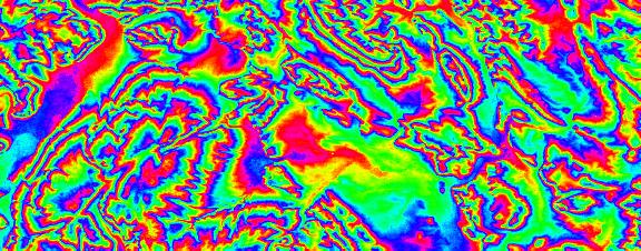
16 Interferogram 16
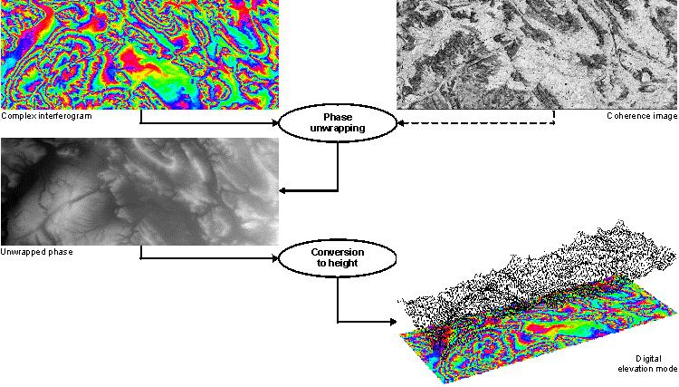
17 17 Phase unwrapping! looking for the correct integer number of phase cycles that needs to be added to each phase measurement to obtain the correct slant range distance! absolute phase is wrapped into the interval (-π,+π] ambiguity problem! solving ambiguity referred to as phase unwrapping
18 Phase unwrapping! no standard procedure to solve the phase unwrapping problem! large variety of algorithms developed! generally trade off between accuracy of solution and computational requirements! two types of strategy to solve the phase unwrapping problem " path-following methods (local approach) " minimum-norm methods (global approach) 18
19 Phase unwrapping! ways of simplifying the problem " filtering the phase before unwrapping " removing topographic phase before unwrapping requires reference DEM " choice of geometry: short baseline 19
20 Conversion phase to height! adding of topographic phase (in case removed before phase unwrapping)! creation of the elevation map! estimating an error map based on coherence image, baseline and unwrapped phase! mapping from slant range to ground range geometry 20
21 Digital elevation model 21
22 Geocoding! defines the transformation between local coordinate system and global Cartesian coordinates! two different ways of implementation " Doppler frequency calculated on DEM positions and satellite orbit (requires reference DEM) " refinement of baseline and imaging geometry (no reference DEM required) 22

23 Digital elevation model 23
24 Interferometric techniques! across-track interferometry " regular airborne geometry! along-track interferometry " airborne geometry " monitoring ocean currents or other moving objects! repeat-pass interferometry " usually spaceborne! differential interferometry " change detection 24
25 25 Differential interferogram! change detection: measurement of small-scale movements in the vertical direction! displacement measured is not vertical, but along the viewing direction! relative accuracy of the order of a few centimetres or even less vs. absolute accuracy of digital elevation models of about meters (for ERS data)

26 Interferometric applications 26


27 27 Seismic events Source: Massonnet et al. (1993)

28 28 Volcanic hazards Source: Massonnet (1997)

29 29 Glacier research Image Credits: Received by CCRS Pre-processed by RSI Interpretation: Laurence Gray, CCRS Karim Mattar, Intermap Paris Vachon, CCRS CSA, 1996

30 Land subsidence Source: 30

31 31 Forestry interferometric correlation backscatter intensity backscatter change Source: Strozzi and Wegmüller (1997)

32 Questions
Interferometric processing. Rüdiger Gens
 Rüdiger Gens Why InSAR processing? extracting three-dimensional information out of a radar image pair covering the same area digital elevation model change detection 2 Processing chain 3 Processing chain
In addition, the image registration and geocoding functionality is also available as a separate GEO package.
 GAMMA Software information: GAMMA Software supports the entire processing from SAR raw data to products such as digital elevation models, displacement maps and landuse maps. The software is grouped into
Interferometry Tutorial with RADARSAT-2 Issued March 2014 Last Update November 2017
 Sentinel-1 Toolbox with RADARSAT-2 Issued March 2014 Last Update November 2017 Luis Veci Copyright 2015 Array Systems Computing Inc. http://www.array.ca/ http://step.esa.int with RADARSAT-2 The goal of
Sentinel-1 Toolbox. TOPS Interferometry Tutorial Issued May 2014
 Sentinel-1 Toolbox TOPS Interferometry Tutorial Issued May 2014 Copyright 2015 Array Systems Computing Inc. http://www.array.ca/ https://sentinel.esa.int/web/sentinel/toolboxes Interferometry Tutorial
Sentinel-1 Toolbox. Interferometry Tutorial Issued March 2015 Updated August Luis Veci
 Sentinel-1 Toolbox Interferometry Tutorial Issued March 2015 Updated August 2016 Luis Veci Copyright 2015 Array Systems Computing Inc. http://www.array.ca/ http://step.esa.int Interferometry Tutorial The
InSAR Operational and Processing Steps for DEM Generation
 InSAR Operational and Processing Steps for DEM Generation By F. I. Okeke Department of Geoinformatics and Surveying, University of Nigeria, Enugu Campus Tel: 2-80-5627286 Email:francisokeke@yahoo.com Promoting
InSAR DEM; why it is better?
 InSAR DEM; why it is better? What is a DEM? Digital Elevation Model (DEM) refers to the process of demonstrating terrain elevation characteristics in 3-D space, but very often it specifically means the
Terrain correction. Backward geocoding. Terrain correction and ortho-rectification. Why geometric terrain correction? Rüdiger Gens
 Terrain correction and ortho-rectification Terrain correction Rüdiger Gens Why geometric terrain correction? Backward geocoding remove effects of side looking geometry of SAR images necessary step to allow
A Correlation Test: What were the interferometric observation conditions?
 A Correlation Test: What were the interferometric observation conditions? Correlation in Practical Systems For Single-Pass Two-Aperture Interferometer Systems System noise and baseline/volumetric decorrelation
Operational process interferometric for the generation of a digital model of ground Applied to the couple of images ERS-1 ERS-2 to the area of Algiers
 Operational process interferometric for the generation of a digital model of ground Applied to the couple of images ERS-1 ERS-2 to the area of Algiers F. Hocine, M.Ouarzeddine, A. elhadj-aissa,, M. elhadj-aissa,,
Synthetic Aperture Radar Interferometry (InSAR)
") CEE 6100 / CSS 6600 Remote Sensing Fundamentals 1 Synthetic Aperture Radar Interferometry (InSAR) Adapted from and the ESA Interferometric SAR overview by Rocca et al. http://earth.esa.int/workshops/ers97/program-details/speeches/rocca-et-al/
CEE 6100 / CSS 6600 Remote Sensing Fundamentals 1 Synthetic Aperture Radar Interferometry (InSAR) Adapted from and the ESA Interferometric SAR overview by Rocca et al. http://earth.esa.int/workshops/ers97/program-details/speeches/rocca-et-al/
Lateral Ground Movement Estimation from Space borne Radar by Differential Interferometry.
 Lateral Ground Movement Estimation from Space borne Radar by Differential Interferometry. Abstract S.Sircar 1, 2, C.Randell 1, D.Power 1, J.Youden 1, E.Gill 2 and P.Han 1 Remote Sensing Group C-CORE 1
INSAR DEMS; ACHIEVEMENTS AND BENEFITS
 INSAR DEMS; ACHIEVEMENTS AND BENEFITS Parviz TARIKHI, Iran Key words: remote sensing, InSAR, DEM, deformation measurement, Iran SUMMARY InSAR is a radar technique for combining synthetic aperture radar
Interferometry Module for Digital Elevation Model Generation
 Interferometry Module for Digital Elevation Model Generation In order to fully exploit processes of the Interferometry Module for Digital Elevation Model generation, the European Space Agency (ESA) has
Concept and methodology of SAR Interferometry technique
 Concept and methodology of SAR Interferometry technique March 2016 Differen;al SAR Interferometry Young s double slit experiment - Construc;ve interference (bright) - Destruc;ve interference (dark) http://media-2.web.britannica.com/eb-media/96/96596-004-1d8e9f0f.jpg
Scene Matching on Imagery
 Scene Matching on Imagery There are a plethora of algorithms in existence for automatic scene matching, each with particular strengths and weaknesses SAR scenic matching for interferometry applications
Differential Interferometry and Geocoding Software DIFF&GEO
 Documentation User s Guide Differential Interferometry and Geocoding Software DIFF&GEO Geocoding and Image Registration Version 1.6 May 2011 GAMMA Remote Sensing AG, Worbstrasse 225, CH-3073 Gümligen,
DIGITAL ELEVATION MODEL GENERATION FROM INTERFEROMETRIC SYNTHETIC APERTURE RADAR USING MULTI-SCALE METHOD
 DIGITAL ELEVATION MODEL GENERATION FROM INTERFEROMETRIC SYNTHETIC APERTURE RADAR USING MULTI-SCALE METHOD Jung Hum Yu 1, Linlin Ge, Chris Rizos School of Surveying and Spatial Information Systems University
MULTI-TEMPORAL INTERFEROMETRIC POINT TARGET ANALYSIS
 MULTI-TEMPORAL INTERFEROMETRIC POINT TARGET ANALYSIS U. WEGMÜLLER, C. WERNER, T. STROZZI, AND A. WIESMANN Gamma Remote Sensing AG. Thunstrasse 130, CH-3074 Muri (BE), Switzerland wegmuller@gamma-rs.ch,
Interferometric SAR Processor - ISP
 Documentation User s Guide Interferometric SAR Processor - ISP Version 1.4 November 2009 GAMMA Remote Sensing AG, Worbstrasse 225, CH-3073 Gümligen, Switzerland tel: +41-31-951 70 05, fax: +41-31-951 70
Three-dimensional digital elevation model of Mt. Vesuvius from NASA/JPL TOPSAR
 Cover Three-dimensional digital elevation model of Mt. Vesuvius from NASA/JPL TOPSAR G.ALBERTI, S. ESPOSITO CO.RI.S.T.A., Piazzale V. Tecchio, 80, I-80125 Napoli, Italy and S. PONTE Department of Aerospace
The 2017 InSAR package also provides support for the generation of interferograms for: PALSAR-2, TanDEM-X
 Technical Specifications InSAR The Interferometric SAR (InSAR) package can be used to generate topographic products to characterize digital surface models (DSMs) or deformation products which identify
Sentinel-1 InSAR AP workshop
 Sentinel-1 InSAR AP workshop Sentinel-1 InSAR progress and experience at GAMMA U. Wegmüller, C. Werner, A. Wiesmann, T. Strozzi Gamma Remote Sensing AG - Progress made since S1A Expert Users meeting at
RADARGRAMMETRY AND INTERFEROMETRY SAR FOR DEM GENERATION
 RADARGRAMMETRY AND INTERFEROMETRY SAR FOR DEM GENERATION Jung Hum Yu 1, Xiaojing Li, Linlin Ge, and Hsing-Chung Chang School of Surveying and Spatial Information Systems University of New South Wales,
Playa del Rey, California InSAR Ground Deformation Monitoring
 Playa del Rey, California InSAR Ground Deformation Monitoring Master Document Ref.: RV-14524 July 13, 2009 SUBMITTED TO: ATTN: Mr. Rick Gailing Southern California Gas Company 555 W. Fifth Street (Mail
First TOPSAR image and interferometry results with TerraSAR-X
 First TOPSAR image and interferometry results with TerraSAR-X A. Meta, P. Prats, U. Steinbrecher, R. Scheiber, J. Mittermayer DLR Folie 1 A. Meta - 29.11.2007 Introduction Outline TOPSAR acquisition mode
PolSARpro v4.03 Forest Applications
 PolSARpro v4.03 Forest Applications Laurent Ferro-Famil Lecture on polarimetric SAR Theory and applications to agriculture & vegetation Thursday 19 April, morning Pol-InSAR Tutorial Forest Application
Repeat-pass SAR Interferometry Experiments with Gaofen-3: A Case Study of Ningbo Area
 Repeat-pass SAR Interferometry Experiments with Gaofen-3: A Case Study of Ningbo Area Tao Zhang, Xiaolei Lv, Bing Han, Bin Lei and Jun Hong Key Laboratory of Technology in Geo-spatial Information Processing
LANDSLIDE PHENOMENA IN SEVAN NATIONAL PARK - ARMENIA
 LANDSLIDE PHENOMENA IN SEVAN NATIONAL PARK - ARMENIA Andon Dimitrov Lazarov (1), Dimitar Minchev (2), Gurgen Aleksanyan (3), (1) Bourgas Free University, 62 San Stefano Str., 8000 Bourgas, Bulgaria,Email:
GAMMA Software. Introduction:
 v1.1, 1-Dec-2017 page 1 GAMMA Software Introduction: GAMMA Software supports the entire processing chain from SAR raw data to products such as digital elevation models, displacement maps and landuse maps.
DINSAR: Differential SAR Interferometry
 DINSAR: Differential SAR Interferometry Fabio Rocca 1 SAR interferometric phase: ground motion contribution If a scatterer on the ground slightly changes its relative position in the time interval between
PSI Precision, accuracy and validation aspects
 PSI Precision, accuracy and validation aspects Urs Wegmüller Charles Werner Gamma Remote Sensing AG, Gümligen, Switzerland, wegmuller@gamma-rs.ch Contents Aim is to obtain a deeper understanding of what
Ground Subsidence Monitored by L-band Satellite Radar. Interferometry
 Ground Subsidence Monitored by L-band Satellite Radar Interferometry Hsing-Chung Chang, Ming-han Chen, Lijiong Qin, Linlin Ge and Chris Rizos Satellite Navigation And Positioning Group School of Surveying
Playa del Rey, California InSAR Ground Deformation Monitoring
 Document Title Playa del Rey, California InSAR Ground Deformation Monitoring Prepared By: (signature / date) Ref.: RV-14524 Project Manager: xxxxxx July 13, 2009 SUBMITTED TO: ATTN: Mr. Rick Gailing Southern
Course Outline (1) #6 Data Acquisition for Built Environment. Fumio YAMAZAKI
 #6 Data Acquisition for Built Environment. Fumio YAMAZAKI") AT09.98 Applied GIS and Remote Sensing for Disaster Mitigation #6 Data Acquisition for Built Environment 9 October, 2002 Fumio YAMAZAKI yamazaki@ait.ac.th http://www.star.ait.ac.th/~yamazaki/ Course Outline
AT09.98 Applied GIS and Remote Sensing for Disaster Mitigation #6 Data Acquisition for Built Environment 9 October, 2002 Fumio YAMAZAKI yamazaki@ait.ac.th http://www.star.ait.ac.th/~yamazaki/ Course Outline
Interferometric Synthetic-Aperture Radar (InSAR) Basics
 Basics") Interferometric Synthetic-Aperture Radar (InSAR) Basics 1 Outline SAR limitations Interferometry SAR interferometry (InSAR) Single-pass InSAR Multipass InSAR InSAR geometry InSAR processing steps Phase
Interferometric Synthetic-Aperture Radar (InSAR) Basics 1 Outline SAR limitations Interferometry SAR interferometry (InSAR) Single-pass InSAR Multipass InSAR InSAR geometry InSAR processing steps Phase
SENTINEL-1 SUPPORT IN THE GAMMA SOFTWARE
 SENTINEL-1 SUPPORT IN THE GAMMA SOFTWARE Urs Wegmüller, Charles Werner, Tazio Strozzi, Andreas Wiesmann, Othmar Frey, and Maurizio Santoro Gamma Remote Sensing, Worbstrasse 225, 3073 Gümligen BE, Switzerland
GAMMA Interferometric Point Target Analysis Software (IPTA): Users Guide
: Users Guide") GAMMA Interferometric Point Target Analysis Software (IPTA): Users Guide Contents User Handbook Introduction IPTA overview Input data Point list generation SLC point data Differential interferogram point
GAMMA Interferometric Point Target Analysis Software (IPTA): Users Guide Contents User Handbook Introduction IPTA overview Input data Point list generation SLC point data Differential interferogram point
LAND SUBSIDENCE WITH SENTINEL-1 using SNAP
 _p TRAINING KIT HAZA03 LAND SUBSIDENCE WITH SENTINEL-1 using SNAP Table of Contents 1 Introduction... 2 2 Training... 2 2.1 Data used... 2 2.2 Software in RUS environment... 2 3 Step by step... 3 3.1 Data
2-PASS DIFFERENTIAL INTERFEROMETRY IN THE AREA OF THE SLATINICE ABOVE- LEVEL DUMP. Milan BOŘÍK 1
 2-PASS DIFFERENTIAL INTERFEROMETRY IN THE AREA OF THE SLATINICE ABOVE- LEVEL DUMP Milan BOŘÍK 1 1 Department of Mathematics, Faculty of Civil Engineering, Czech Technical University in Prague, Thákurova
Individual Interferograms to Stacks!
 Individual Interferograms to Stacks! Piyush Agram! Jet Propulsion Laboratory!! Jun 29, 2015! @UNAVCO! Thanks to my colleagues from JPL, Caltech, Stanford University and from all over the world for providing
APPLICATION OF SAR INTERFEROMETRIC TECHNIQUES FOR SURFACE DEFORMATION MONITORING
 APPLICATION OF SAR INTERFEROMETRIC TECHNIQUES FOR SURFACE DEFORMATION MONITORING Urs Wegmüller, Charles Werner, Tazio Strozzi, and Andreas Wiesmann Gamma Remote Sensing, Worbstrasse 225, 3073 Gümligen,
Interferometric SAR Processing
 Documentation - Theory Interferometric SAR Processing Version 1.0 November 2007 GAMMA Remote Sensing AG, Worbstrasse 225, CH-3073 Gümligen, Switzerland tel: +41-31-951 70 05, fax: +41-31-951 70 08, email:
INTERFEROMETRIC MULTI-CHROMATIC ANALYSIS OF HIGH RESOLUTION X-BAND DATA
 INTERFEROMETRIC MULTI-CHROMATIC ANALYSIS OF HIGH RESOLUTION X-BAND DATA F. Bovenga (1), V. M. Giacovazzo (1), A. Refice (1), D.O. Nitti (2), N. Veneziani (1) (1) CNR-ISSIA, via Amendola 122 D, 70126 Bari,
IMPROVING DEMS USING SAR INTERFEROMETRY. University of British Columbia. ABSTRACT
 IMPROVING DEMS USING SAR INTERFEROMETRY Michael Seymour and Ian Cumming University of British Columbia 2356 Main Mall, Vancouver, B.C.,Canada V6T 1Z4 ph: +1-604-822-4988 fax: +1-604-822-5949 mseymour@mda.ca,
Sentinel-1 Toolbox. Offset Tracking Tutorial Issued August Jun Lu Luis Veci
 Sentinel-1 Toolbox Offset Tracking Tutorial Issued August 2016 Jun Lu Luis Veci Copyright 2016 Array Systems Computing Inc. http://www.array.ca/ http://step.esa.int Offset Tracking Tutorial The goal of
ERS AND ENVISAT DIFFERENTIAL SAR INTERFEROMETRY FOR SUBSIDENCE MONITORING
 ERS AND ENVISAT DIFFERENTIAL SAR INTERFEROMETRY FOR SUBSIDENCE MONITORING Urs Wegmüller 1, Tazio Strozzi 1, and Luigi Tosi 2 1 Gamma Remote Sensing, Thunstrasse 130, CH-3074 Muri b. Bern, Switzerland Tel:
Radar Coherent Backscatter!
 Radar Coherent Backscatter! Pixels in a radar image are a complex phasor representation of the coherent backscatter from the resolution element on the ground and the propagation phase delay! Interferometric
The STUN algorithm for Persistent Scatterer Interferometry
 [1/27] The STUN algorithm for Persistent Scatterer Interferometry Bert Kampes, Nico Adam 1. Theory 2. PSIC4 Processing 3. Conclusions [2/27] STUN Algorithm Spatio-Temporal Unwrapping Network (STUN) 4 1D
Individual Interferograms to Stacks
 Individual Interferograms to Stacks Piyush Agram Jet Propulsion Laboratory Aug 1, 2016 @UNAVCO Thanks to my colleagues from JPL, Caltech, Stanford University and from all over the world for providing images
Airborne Differential SAR Interferometry: First Results at L-Band
 1516 IEEE TRANSACTIONS ON GEOSCIENCE AND REMOTE SENSING, VOL. 41, NO. 6, JUNE 2003 Airborne Differential SAR Interferometry: First Results at L-Band Andreas Reigber, Member, IEEE, and Rolf Scheiber Abstract
Ice surface velocities using SAR
 Ice surface velocities using SAR Thomas Schellenberger, PhD ESA Cryosphere Remote Sensing Training Course 2018 UNIS Longyearbyen, Svalbard 12 th June 2018 thomas.schellenberger@geo.uio.no Outline Synthetic
Progress In Electromagnetics Research M, Vol. 14, 15 32, 2010 RECONSTRUCTING HIGH-ACCURACY DEM WITH PRECISE ORBIT DATA AND EXTERNAL DEM
 Progress In Electromagnetics Research M, Vol. 14, 15 32, 2010 RECONSTRUCTING HIGH-ACCURACY DEM WITH PRECISE ORBIT DATA AND EXTERNAL DEM A. Bin School of Marine Sciences Sun Yat-sen University Guangzhou
SNAP-Sentinel-1 in a Nutshell
 SNAP-Sentinel-1 in a Nutshell Dr. Andrea Minchella 1 st ESA Advanced Training Course on Remote Sensing of the Cryosphere 13 September 2016, University of Leeds, Leeds, UK What is SNAP? Credit: SNAP The
AIRBORNE synthetic aperture radar (SAR) systems
 systems") IEEE GEOSCIENCE AND REMOTE SENSING LETTERS, VOL 3, NO 1, JANUARY 2006 145 Refined Estimation of Time-Varying Baseline Errors in Airborne SAR Interferometry Andreas Reigber, Member, IEEE, Pau Prats, Student
IEEE GEOSCIENCE AND REMOTE SENSING LETTERS, VOL 3, NO 1, JANUARY 2006 145 Refined Estimation of Time-Varying Baseline Errors in Airborne SAR Interferometry Andreas Reigber, Member, IEEE, Pau Prats, Student
RESOLUTION enhancement is achieved by combining two
 IEEE GEOSCIENCE AND REMOTE SENSING LETTERS, VOL. 3, NO. 1, JANUARY 2006 135 Range Resolution Improvement of Airborne SAR Images Stéphane Guillaso, Member, IEEE, Andreas Reigber, Member, IEEE, Laurent Ferro-Famil,
I-PAF SRTM X-SAR Processing Chain: Algorithms and Analysis of First Results
 I-PAF SRTM X-SAR Processing Chain: Algorithms and Analysis of First Results P. AMMENDOLA(*), E. LOPINTO(**),C. MARZO (***), G. MILILLO (***), G. RICCOBONO (***), G. R. VERDONE (**), R. VIGGIANO (**) (*)ASI
Efficient Simulation of SAR Interferograms of Large Areas and of Rugged Terrain
 IEEE TRANSACTIONS ON GEOSCIENCE AND REMOTE SENSING, VOL. 41, NO. 6, JUNE 2003 1415 Efficient Simulation of SAR Interferograms of Large Areas and of Rugged Terrain Michael Eineder, Member, IEEE Abstract
DETECTION AND QUANTIFICATION OF ROCK GLACIER. DEFORMATION USING ERS D-InSAR DATA
 DETECTION AND QUANTIFICATION OF ROCK GLACIER DEFORMATION USING ERS D-InSAR DATA Lado W. Kenyi 1 and Viktor Kaufmann 2 1 Institute of Digital Image Processing, Joanneum Research Wastiangasse 6, A-8010 Graz,
SUBSIDENCE MONITORING USING CONTIGUOUS AND PS-INSAR: QUALITY ASSESSMENT BASED ON PRECISION AND RELIABILITY
 Proceedings, 11 th FIG Symposium on Deformation Measurements, Santorini, Greece, 2003. SUBSIDENCE MONITORING USING CONTIGUOUS AND PS-INSAR: QUALITY ASSESSMENT BASED ON PRECISION AND RELIABILITY Ramon F.
LONG-TERM SUBSIDENCE MONITORING OF CITY AREAS AT NORDIC LATITUDES USING ERS SAR DATA
 LONG-TERM SUBSIDENCE MONITORING OF CITY AREAS AT NORDIC LATITUDES USING ERS SAR DATA Tom R. Lauknes (1,2), Geir Engen (1), Kjell A. Høgda (1), Inge Lauknes (1), Torbjørn Eltoft (2), Dan J. Weydahl (3)
fraction of Nyquist
 differentiator 4 2.1.2.3.4.5.6.7.8.9 1 1 1/integrator 5.1.2.3.4.5.6.7.8.9 1 1 gain.5.1.2.3.4.5.6.7.8.9 1 fraction of Nyquist Figure 1. (top) Transfer functions of differential operators (dotted ideal derivative,
FIRST RESULTS OF THE ALOS PALSAR VERIFICATION PROCESSOR
 FIRST RESULTS OF THE ALOS PALSAR VERIFICATION PROCESSOR P. Pasquali (1), A. Monti Guarnieri (2), D. D Aria (3), L. Costa (3), D. Small (4), M. Jehle (4) and B. Rosich (5) (1) sarmap s.a., Cascine di Barico,
SNAP-Sentinel-1 in a Nutshell
 SNAP-Sentinel-1 in a Nutshell Dr. Andrea Minchella 21-22/01/2016 ESA SNAP-Sentinel-1 Training Course Satellite Applications Catapult - Electron Building, Harwell, Oxfordshire What is SNAP? Credit: SNAP
ALOS PALSAR SCANSAR INTERFEROMETRY AND ITS APPLICATION IN WENCHUAN EARTHQUAKE
 ALOS PALSAR SCANSAR INTERFEROMETRY AND ITS APPLICATION IN WENCHUAN EARTHQUAKE Cunren Liang (1) (2), Qiming Zeng (1) (2), Jianying Jia (1) (2), Jian Jiao (1) (2), Xiai Cui (1) (2) (1) (2), Xiao Zhou (1)
INTEGRATED USE OF INTERFEROMETRIC SAR DATA AND LEVELLING MEASUREMENTS FOR MONITORING LAND SUBSIDENCE
 INTEGRATED USE OF INTERFEROMETRIC SAR DATA AND LEVELLING MEASUREMENTS FOR MONITORING LAND SUBSIDENCE Yueqin Zhou *, Martien Molenaar *, Deren Li ** * International Institute for Aerospace Survey and Earth
Signal Processing Laboratory
 C.S.L Liege Science Park Avenue du Pré-Aily B-4031 ANGLEUR Belgium Tel: +32.4.382.46.00 Fax: +32.4.367.56.13 Signal Processing Laboratory Anne Orban VITO June 16, 2011 C. Barbier : the team Remote Sensing
A NEW APPROACH FOR LONG TERM MONITORING OF DEFORMATIONS BY DIFFERENTIAL SAR INTERFEROMETRY
 A NEW APPROACH FOR LONG TERM MONITORING OF DEFORMATIONS BY DIFFERENTIAL SAR INTERFEROMETRY A NEW APPROACH FOR LONG TERM MONITORING OF DEFORMATIONS BY DIFFERENTIAL SAR INTERFEROMETRY PROEFSCHRIFT ter verkrijging
ENVI 5 & E3De. The Next Generation of Image Analysis
 ENVI 5 & E3De The Next Generation of Image Analysis The information contained in this document pertains to software products and services that are subject to the controls of the Export Administration Regulations
Results of UAVSAR Airborne SAR Repeat-Pass Multi- Aperture Interferometry
 Results of UAVSAR Airborne SAR Repeat-Pass Multi- Aperture Interferometry Bryan Riel, Ron Muellerschoen Jet Propulsion Laboratory, California Institute of Technology 2011 California Institute of Technology.
Generate Glacier Velocity Maps with the Sentinel-1 Toolbox
 Making remote-sensing data accessible since 1991 Generate Glacier Velocity Maps with the Sentinel-1 Toolbox Adapted from the European Space Agency s STEP community platform In this document you will find:
Hydrological network detection for SWOT data. S. Lobry, F. Cao, R. Fjortoft, JM Nicolas, F. Tupin
 Hydrological network detection for SWOT data S. Lobry, F. Cao, R. Fjortoft, JM Nicolas, F. Tupin IRS SPU avril 2016 SWOT mission Large water bodies detection Fine network detection Further works page 1
InSAR Processing. Sentinel 1 data Case study of subsidence in Mexico city. Marie-Pierre Doin, Cécile Lasserre, Raphaël Grandin, Erwan Pathier
 1 InSAR Processing Sentinel 1 data Case study of subsidence in Mexico city Marie-Pierre Doin, Cécile Lasserre, Raphaël Grandin, Erwan Pathier NSBAS processing chain (based on ROI_PAC): ROI-PAC: Rosen et
Memorandum. Clint Slatton Prof. Brian Evans Term project idea for Multidimensional Signal Processing (EE381k)
") Memorandum From: To: Subject: Date : Clint Slatton Prof. Brian Evans Term project idea for Multidimensional Signal Processing (EE381k) 16-Sep-98 Project title: Minimizing segmentation discontinuities in
Memorandum From: To: Subject: Date : Clint Slatton Prof. Brian Evans Term project idea for Multidimensional Signal Processing (EE381k) 16-Sep-98 Project title: Minimizing segmentation discontinuities in
Geometric and Radiometric Calibration of RADARSAT Images. David Small, Francesco Holecz, Erich Meier, Daniel Nüesch, and Arnold Barmettler
 RADARSAT Terrain Geocoding and Radiometric Correction over Switzerland Geometric and Radiometric Calibration of RADARSAT Images David Small, Francesco Holecz, Erich Meier, Daniel Nüesch, and Arnold Barmettler
Sentinel-1 processing with GAMMA software
 Documentation User s Guide Sentinel-1 processing with GAMMA software Including an example of Sentinel-1 SLC co-registration and differential interferometry Version 1.1 May 2015 GAMMA Remote Sensing AG,
Coherence Based Polarimetric SAR Tomography
 I J C T A, 9(3), 2016, pp. 133-141 International Science Press Coherence Based Polarimetric SAR Tomography P. Saranya*, and K. Vani** Abstract: Synthetic Aperture Radar (SAR) three dimensional image provides
SBAS- InSAR SERVICE WITHIN THE G- POD PLATFORM
 SBAS- InSAR SERVICE WITHIN THE G- POD PLATFORM USER MANUAL Prepared by: Reference: Issue: 2 Revision: 0 Claudio De Luca (CNR- IREA) Francesco Casu (CNR- IREA) IREA- GPOD- UM- 14-003 Date of Issue: November
NEST 4C-1.1: an ESA toolbox for scientific exploitation of SAR data
 NEST 4C-1.1: an ESA toolbox for scientific exploitation of SAR data Andrea Minchella RSAC c/o European Space Agency ESRIN EO Science, Applications and New Technologies Department Exploitation & Services
Multi Baseline Interferometric Techniques and
 Pagina 1 di 11 FRINGE 96 Multi Baseline Interferometric Techniques and Applications A.Ferretti, A. Monti Guarnieri, C.Prati and F.Rocca Dipartimento di Elettronica e Informazione (DEI) Politecnico di Milano
Practical work on SAR Interferometry Data Processing using DORIS Software Y.S. Rao CSRE, IIT Bombay
 Practical work on SAR Interferometry Data Processing using DORIS Software Y.S. Rao CSRE, IIT Bombay ysrao@csre.iitb.ac.in Tools : DORIS (Delft Object-Oriented Radar Interferometric Software) is freely
ALOS PALSAR. Orthorectification Tutorial Issued March 2015 Updated August Luis Veci
 ALOS PALSAR Orthorectification Tutorial Issued March 2015 Updated August 2016 Luis Veci Copyright 2015 Array Systems Computing Inc. http://www.array.ca/ http://step.esa.int ALOS PALSAR Orthorectification
Combining Airborne LIDAR and Satellite RADAR for a Dynamic DEM. Ramon Hanssen, Delft University of Technology
 Combining Airborne LIDAR and Satellite RADAR for a Dynamic DEM Ramon Hanssen, Delft University of Technology 1 Release 27 September 2 Land surface elevation H(t) = H(t 0 ) + dh(dt) dt Elevation at time
TanDEM-X Interferometric Processing Chain and SAR Products. Thomas Fritz H. Breit, M. Eineder, M. Lachaise & ITP Development Team
 TanDEM-X Interferometric Processing Chain and SAR Products Thomas Fritz H. Breit, M. Eineder, M. Lachaise & ITP Development Team TanDEM-X Science Meeting Nov. 2008 From Acquisitions to Products - The TanDEM-X
NEST: an ESA toolbox for scientific exploitation of SAR data
 NEST: an ESA toolbox for scientific exploitation of SAR data M.Engdahl (ESA-ESRIN), A. Minchella (RSAC c/o ESA), P. Marinkovic (Ppo.Labs), L. Veci (Array Systems Computing) 26/07/2012 IGARSS 2012 Munich
FAST SOLUTION OF PHASE UNWRAPPING PARTIAL DIFFERENTIAL EQUATION USING WAVELETS
 Tenth MSU Conference on Differential Equations and Computational Simulations. Electronic Journal of Differential Equations, Conference 23 (2016), pp. 119 129. ISSN: 1072-6691. URL: http://ejde.math.txstate.edu
AMBIGUOUS PSI MEASUREMENTS
 AMBIGUOUS PSI MEASUREMENTS J. Duro (1), N. Miranda (1), G. Cooksley (1), E. Biescas (1), A. Arnaud (1) (1). Altamira Information, C/ Còrcega 381 387, 2n 3a, E 8037 Barcelona, Spain, Email: javier.duro@altamira
Motion compensation and the orbit restitution
 InSA R Contents Introduction and objectives Pi-SAR Motion compensation and the orbit restitution InSAR algorithm DEM generation Evaluation Conclusion and future work Introduction and Objectives L-band
GMES TERRAFIRMA. Validation of existing processing chains in Terrafirma stage 2 LIST OF OSP DELIVERABLES EXTENDED
 GMES TERRAFIRMA ESRIN/Contract no. 19366/05/I-E Validation of existing processing chains in Terrafirma stage 2 LIST OF OSP DELIVERABLES EXTENDED 5 th July 2007 Final version - ERS M. Crosetto, M. Agudo
TANDEM-X: DEM ACQUISITION IN THE THIRD YEAR ERA
 TANDEM-X: DEM ACQUISITION IN THE THIRD YEAR ERA D. Borla Tridon, M. Bachmann, D. Schulze, C. J. Ortega Miguez, M. D. Polimeni, M. Martone and TanDEM-X Team Microwaves and Radar Institute, DLR 5 th International
Mission Status and Data Availability: TanDEM-X
 Mission Status and Data Availability: TanDEM-X Irena Hajnsek, Thomas Busche, Alberto Moreira & TanDEM-X Team Microwaves and Radar Institute, German Aerospace Center irena.hajnsek@dlr.de 26-Jan-2009 Outline
PROBLEMS AND SOLUTIONS FOR INSAR DIGITAL ELEVATION MODEL GENERATION OF MOUNTAINOUS TERRAIN. M. Eineder
 PROBLEMS AND SOLUTIONS FOR INSAR DIGITAL ELEVATION MODEL GENERATION OF MOUNTAINOUS TERRAIN M. Eineder German Aerospace Center (DLR), Oberpfaffenhofen, D-82234 Wessling, Germany, Email: Michael.Eineder@dlr.de
Sentinel-1 InSAR Phase Unwrapping using S1TBX and SNAPHU
 Making remote-sensing data accessible since 1991 Sentinel-1 InSAR Phase Unwrapping using S1TBX and SNAPHU Adapted from the European Space Agency s STEP community platform In this document you will find:
SARscape. Table of Contents. Preface 1. Overview 3. Basic Module 5. Focusing Module 11. Gamma and Gaussian Filtering Module 11
 Table of Contents Preface 1 Overview 3 Basic Module 5 Focusing Module 11 Gamma and Gaussian Filtering Module 11 Interferometry Module 13 ScanSAR Interferometry Module 18 Polarimetry and Polarimetric Interferometry
SENTINEL-1 PRECISE ORBIT CALIBRATION AND VALIDATION
 SENTINEL-1 PRECISE ORBIT CALIBRATION AND VALIDATION Andrea Monti Guarnieri, Simone Mancon, and Stefano Tebaldini Politecnico di Milano, Italy ABSTRACT In this paper, we propose a model-based procedure
URBAN FOOTPRINT MAPPING WITH SENTINEL-1 DATA
 URBAN FOOTPRINT MAPPING WITH SENTINEL-1 DATA Data: Sentinel-1A IW SLC 1SSV: S1A_IW_SLC 1SSV_20160102T005143_20160102T005208_009308_00D72A_849D S1A_IW_SLC 1SSV_20160126T005142_20160126T005207_009658_00E14A_49C0
CRUCIAL POINTS OF INTERFEROMETRIC PROCESSING FOR DEM GENERATION USING HIGH RESOLUTION SAR DATA
 CRUCIAL POINTS OF INTERFEROMETRIC PROCESSING FOR DEM GENERATION USING HIGH RESOLUTION SAR DATA Sefercik, U. G.*, Dana, I.** * Zonguldak Karaelmas University, Turkey ugsefercik@hotmail.com ** Romanian Space
WIDE AREA DEFORMATION MAP GENERATION WITH TERRASAR-X DATA: THE TOHOKU-OKI EARTHQUAKE 2011 CASE
 WIDE AREA DEFORMATION MAP GENERATION WITH TERRASAR-X DATA: THE TOHOKU-OKI EARTHQUAKE 2011 CASE Nestor Yague-Martinez (1), Michael Eineder (2), Christian Minet (2), Birgitt Schättler (2) (1) Starlab Barcelona
Interferometric Evaluation of Sentinel-1A TOPS data
 Interferometric Evaluation of Sentinel-1A TOPS data N. Yague-Martinez, F. Rodriguez Gonzalez, R. Brcic, R. Shau Remote Sensing Technology Institute. DLR, Germany ESTEC/Contract No. 4000111074/14/NL/MP/lf
ON THE PHYSICAL NATURE OF URBAN SAR PERMANENT SCATTERERS
 ON THE PHYSICAL NATURE OF URBAN SAR PERMANENT SCATTERERS Daniele Perissin (1), Claudio Prati (1) (1) Politecnico di Milano, Piazza L. da Vinci 32, 20133 Milano, Italy, Email: perissin@elet.polimi.it KEY